NWS HURRICANES June 3, 2015
|
|
|
- Hortense Wilkinson
- 5 years ago
- Views:
Transcription


1 NWS HURRICANES June 3, 2015

2 Hurricane Season June 1 November 30 2

3 What s the concern? All tropical systems passing within 125nm of central Maryland since 1950
4 Mid-Atlantic Hurricanes Greatest Risk: August 15 to October 15 However June (Agnes 1972) July (Bertha 1996) November (Gordon 1994)

5 Hurricane Meaning? First thing most think of is WIND One of the biggest problems for safety Dates to Spanish exploration of the Americas. Caribbean word for God of the Storm * A storm has SEVERAL threats! 5

6 Inland Flooding Tidal Flooding The 4 Threats Winds <- Saffir-Simpson Wind Scale Tornadoes * Each storm has its own mix of these 4 threats * YOUR threats will depend on this AND where you are 6
7 The 4 Threats Hurricane or Remnant, threats are same
8 The 4 Threats Hurricane or Remnant, threats are same Flooding from Torrential Rain
9 The 4 Threats Hurricane or Remnant, threats are same Flooding from Torrential Rain Tidal Flooding from Surge
10 The 4 Threats Hurricane or Remnant, threats are same Flooding from Torrential Rain Tidal Flooding from Surge Tornados
11 The 4 Threats Hurricane or Remnant, threats are same Flooding from Torrential Rain Tidal Flooding from Surge Tornados Winds
12 The 4 Threats Flooding from Torrential Rain Probably the most underrated threat, yet often biggest issue 1-2 FEET of rain can fall An average rainstorm is <1

13 The 4 Threats Flooding from Torrential Rain The biggest inland killer Often from: Driving into flooded areas Kids playing w/ swollen streams

14 Flooding


15 Lee Remnants 11

16 The 4 Threats Tidal Flooding from Surge The most deadly threat for: * those along tidal shores * watch track S or W of you Think of surge like a slower tsunami

17 The 4 Threats Tornados Many do not realize it, but hurricanes can produce tornado outbreaks upon landfall. Affects targeted areas.
 in recent history (Sept 17,")
18 Tornadoes Tornado production can occur for days after landfall Any time of day/night Remnants of Ivan produced the worst Mid Atlantic tornado outbreak (35 tornadoes) in recent history (Sept 17, 2004).
19 The 4 Threats Winds Typically one of the biggest threats near the landfall region The main threat for mariners Wind speeds usually decrease dramatically after landfall Can have wind gusts above 200 mph
20 High Winds Saffir-Simpson Wind Scale Category Winds Damage Tropical Depression Less than 39 mph Tropical Storm mph One mph Minimal Two mph Moderate Three mph Major Four mph Extensive Five Greater than 155 mph Catastrophic

21
22 The 4 Threats Hurricane or Remnant, threats are same Flooding from Torrential Rain Tidal Flooding from Surge Tornados Winds Which one(s) will impact you & how bad? Depends on: * storm s personality * your particular area!


23 National Weather Service NWS National Hurricane Center Miami, FL Forecasts the track Forecasts the intensity All tropical cyclones around North America! NWS Forecast Office Sterling, VA Forecasts the impacts Forecast the threats For everyone in our local area Building has 10-inch thick walls made from 3000 cubic yards of concrete, reinforced with 45 miles of steel reinforcing rods We work together! To decide where & when to issue WATCHES & WARNINGS

24 Averages are 12, 6, & 3
25 New for 2015 & Trends More GIS Range of Possibilities; Probabilities of x happening Not Just Weather, but Impacts Graphics Duration of Forecast Mixed-Case Text From NHC Less Focus on it will follow this line, with this weather expected Text products Static Images 25


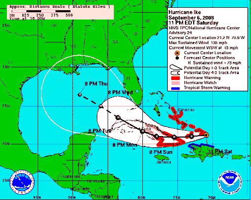
26 Tropical Storm Andrea Issued: 5 A.M. Fri 6/7/13 Reflects forecast at 5 A.M. Friday Most updated forecast always at weather.gov
 Gales on entire Bay Tidal Flooding: * Moderate for Bay &Lwr Potmc (2-3 surge) * Minor along mid/upr Potomac (1-2 surge) Impacts from Andrea")
")

27 High Impact Scenario Western Track or Stronger Storm Heavy Rain w/ flooding (Fri/Fri night): * 4-6 I-95 Corridor and East * 2-4 W of I-95 Corridor Gusty winds (along Bay counties): * 40 mph gusts * A few downed trees/power lines Isolated Tornado (S MD) Gales on entire Bay Tidal Flooding: * Moderate for Bay &Lwr Potmc (2-3 surge) * Minor along mid/upr Potomac (1-2 surge) Impacts from Andrea Baltimore/Washington Region Threat Window (Fri morning Fri night) Issued: 9 A.M. Fri 6/7/13 NWS Baltimore/Washington Range of Threat Window of possibilities will narrow as we near event, with added detail Most Likely Impacts Heavy Rain (moving in this morning through midnight) Flash Flood Watch: E of the Blue Ridge/Catoctins 6 am - 10 pm * 2-4 E of the Blue Ridge/Catoctins (Heaviest I-95 and east) + Flooding likely in I-95 Corridor from Fredericksburg VA to Baltimore * W of the Blue Ridge/Catoctins Heaviest Rainfall: 2 pm to 10 pm Friday Gusty Winds for Calvert & St. Mary s Co. MD * Up to 35 mph Calvert & St. Mary s Co. MD * 25 MPH or less Elsewhere * Gale Warning on Bay & Potomac Around Their Confluence Minor Tidal Flooding * Along Bay & for D.C./Alexandria (1-2 surge thru eve) * Coastal Flood Advisory for A.M. Tide (D.C./Alexandria & N Bay) Reflects forecast at 9 A.M. Friday Most updated forecast always at weather.gov Low Impact Scenario Eastern Track or Weaker Storm Rain * 1-2 Blue Ridge and east * Less than 1 west of the Blue Ridge National Weather Service Baltimore/Washington


28 New for 2015 Communicating Storm Surge Danger: Tidal waters rising up and taking low lying areas Biggest killer for areas 15' above sea level and lower Building a Weather-Ready Nation
29 New for 2015 Communicating Storm Surge Danger: 1) Storm Surge Watches & Warnings Storm Surge Watch - Potential Storm Surge Warning - Expectation Building a Weather-Ready Nation
30 New for 2015 Communicating Storm Surge Danger: Previously: Threat was talked about within Hurricane Warning New for 2015: Alerting public for the most likely area of life threatening storm surge with Storm Surge Watch & Warning Storm Surge Watch - Potential Storm Surge Warning - Expectation Building a Weather-Ready Nation
31 New for 2015 Important Note: Different area than Hurricane Watch/Warning area (wind) Storm Surge Watch: Potential for life threatening surge Storm Surge Warning: Expect life threatening surge Building a Weather-Ready Nation
32 New for 2015 Communicating Storm Surge Danger: 2) Potential Storm Surge Flooding Map Building a Weather-Ready Nation

33 New for 2015 Communicating Storm Surge Danger: Previously: Threat described in text New for 2015: Showing people where flooding will reach Potential Storm Surge Flooding Building a Weather-Ready Nation
34 Communicating Storm Surge Danger: Potential Storm Surge Flooding THIS IS NOT EXPECTED FLOODING THIS IS REASONABLE WORST CASE New for 2015 Building a Weather-Ready Nation
35 Communicating Storm Surge Danger: Potential Storm Surge Flooding THIS IS REASONABLE WORST CASE Begin with issuance of Hurricane/TS watches/warnings Best used by EMs for: evacuation decisions who is at risk? Not to answer Will my area flood? New for 2015 Building a Weather-Ready Nation
36 Communicating Storm Surge Danger: Potential Storm Surge Flooding THIS IS REASONABLE WORST CASE Different than surge watch/warnings & surge expectation still described in our text products. which are most likely New for 2015 Building a Weather-Ready Nation
37 Summing Up New for Communicating Threat #1 of 4: Storm Surge Watch & Warnings Akin to other W & W s Where life-threatening conditions are expected (warning) potential of (watch) Easier for public Potential Storm Surge Flooding Map Akin to Max Potential Snow Where & How High surge could reach w/ worst case track/conditions Needs public explanation to use Building a Weather-Ready Nation

38 Graphical NHC Outlooks Thru 5 days Initial Position X Expected Movement / Threat Area 38
39 Hour-by-Hour Forecast

40 Social Media


41 Warning Type Tsunami Warning Tornado Warning Extreme Wind Warning Flash Flood Warning Hurricane Warning Typhoon Warning Dust Storm Warning WEA Message Tsunami danger on the coast. Go to high ground or move inland. Check local media. NWS Tornado Warning in this area til hh:mm tzt. Take shelter now. Check local media. NWS Extreme Wind Warning this area til hh:mm tzt ddd. Take shelter. NWS Flash Flood Warning this area til hh:mm tzt. Avoid flooded areas. Check local media. -NWS Hurricane Warning this area til hh:mm tzt ddd. Check local media and authorities. NWS Typhoon Warning this area til hh:mm tzt ddd. Check local media and authorities. -NWS Dust Storm Warning in this area til hh:mm tzt ddd. Avoid travel. Check local media. -NWS
42 Summary Full information set = (Most likely / The forecast) + (Best & Worst case scenarios) Greatest Risk here is mid Aug mid Oct 4 Threats Flooding Tidal Flooding Wind Tornadoes Forecast Offices + NHC = NWS team 42
")


43 NOAA National Weather Service Chris Strong Warning Coordination Meteorologist (WCM) noaa.gov Weather-Ready Nation Weather Disasters will come If everyone gets advance notice knows what to do & acts is prepared we will truly be a Weather-Ready Nation!
GC Briefing. Weather Sentinel Tropical Storm Michael. Status at 8 AM EDT (12 UTC) Today (NHC) Discussion. October 11, 2018
 Today (NHC) Discussion. October 11, 2018") GC Briefing Weather Sentinel Tropical Storm Michael October 11, 2018 After making landfall as a high-end category-4 hurricane on the Florida Panhandle, Michael weakened to tropical storm status early this
GC Briefing Weather Sentinel Tropical Storm Michael October 11, 2018 After making landfall as a high-end category-4 hurricane on the Florida Panhandle, Michael weakened to tropical storm status early this
Major Hurricane Matthew Briefing Situation Overview
 Major Hurricane Matthew Briefing Situation Overview THIS IS NOW A WORST CASE STORM SURGE SCENARIO Catastrophic Damage is Anticipated for Coastal Areas. Major Hurricane Matthew is still expected to move
TROPICAL STORM NATE BRIEFING
 TROPICAL STORM NATE BRIEFING 5:00 AM CDT Friday, October 6, 2017 Prepared by: NWS NWSNewOrleans www.weather.gov/neworleans Situation Overview No significant changes to the track forecast this morning.
Tropical Storm Harvey: SE Texas Impacts
 Tropical Storm Harvey: SE Texas Impacts 10 AM CDT UPDATE Thursday, August 24, 2017 Prepared by: Dan Reilly, Brian Kyle PLEASE MUTE YOUR LINES AND DON T PUT ON HOLD! Situation Overview Tropical Storm Harvey
The Wind Hazard: Messaging the Wind Threat & Corresponding Potential Impacts
 The Wind Hazard: Messaging the Wind Threat & Corresponding Potential Impacts Scott Spratt Warning Coordination Meteorologist NWS Melbourne, FL David Sharp Science & Operations Officer NWS Melbourne, FL
Frank Revitte National Weather Service. Weather Forecast Office New Orleans/Baton Rouge
 Frank Revitte National Weather Service Weather Forecast Office New Orleans/Baton Rouge Above normal activity 17 Total Named Storms 7 Tropical Storms 4 Hurricanes 6 Major Hurricanes Not the most active,
Coastal Storm this Weekend
 Weather Briefing Prepared 9 AM EST Feb 5, 2010 Joe Miketta Warning Coordination Meteorologist NOAA s National Weather Service Philadelphia/Mt. Holly NJ Forecast Office 609-261 261-6602 6602 x223 Joseph.Miketta@noaa.gov
WEDNESDAY 30 TH AUGUST, :57 p.m. Tropical Storm Irma forms in the Atlantic. Don t let your guard down, always #Be Ready.
 Chapter 1 - The Set Up In the days leading up to Irma a series of composed and sobering text messages, presented in truncated form below, from Department of Disaster Management warned us of the pending
Very Dangerous Coastal Storm Sandy October 28 th 31 st 2012
 Very Dangerous Coastal Storm Sandy October 28 th 31 st 2012 Prepared 600 PM EDT Monday October 29, 2012 Gary Szatkowski NOAA s NJ Forecast Office Weather.gov/phi Purpose of Briefing Briefing #11 for event
Major Hurricane Earl
 Major Hurricane Earl Advisory 32 North Carolina Threat Assessment Prepared at: 8 AM Thursday September 2, 2010 Hurricane and Tropical Storm Warnings in effect for the North Carolina Coast and Sounds. NWS
Hurricane Recipe. Hurricanes
 Hurricanes A hurricane is a powerful, rotating storm that forms over warm oceans near the Equator. Hurricanes have strong, rotating winds (at least 74 miles per hour), a huge amount of rain, low air pressure,
HURRICANE IRENE. CONFERENCE CALL BRIEFING SLIDES Saturday August 27, :30 AM
 HURRICANE IRENE CONFERENCE CALL BRIEFING SLIDES Saturday August 27, 2011 8:30 AM NHC TRACK AND CONE HURRICANE IRENE WATCHES/WARNINGS Hurricane Warning along south coast including all of Cape Cod and Islands
CATEX Hurricane Zachary
 CATEX Hurricane Zachary EXERCISE, EXERCISE,EXERCISE East Coast CATEX Power Restoration Functional Exercise 2013 This document was prepared under a grant from FEMA's Grants Programs Directorate, U.S. Department
Are You Ready For Hurricane Season? 2018 Hurricane Talk B Y : S T O R M T E A M 8 M E T E O R O L O G I S T J U L I E P H I L L I P S
 Are You Ready For Hurricane Season? 2018 Hurricane Talk B Y : S T O R M T E A M 8 M E T E O R O L O G I S T J U L I E P H I L L I P S About Me I am Currently a Weekday Meteorologist at WFLA Channel 8.
Hurricane Sandy October 28 th 31 st 2012
 Hurricane Sandy October 28 th 31 st 2012 Prepared 530 PM EDT Saturday October 27, 2012 Gary Szatkowski NOAA s NJ Forecast Office Weather.gov/phi Purpose of Briefing Briefing #7 for event Promote situational
Significant Coastal Storm Today through Thursday, 11/7-8. Weather Briefing
 Significant Coastal Storm Today through Thursday, 11/7-8 Weather Briefing Prepared 10:00 am EST Wednesday, November 7, 2012 Presented by Gary Conte, Warning Coordination Meteorologist NOAA s National Weather
NOAA s National Weather Service Philadelphia/Mt. Holly NJ
 Next Briefing Package: Friday, October 2, 2015 no later than 300 PM Hazards and Impacts: Overview: A dangerous weather pattern still threatens our region. Threats include very heavy rainfall, inland river
Hurricanes. Environmental Geology Mr. Paul Lowrey. Stacey Singleton, Cassandra Combs, Dwight Stephenson, Matt Smithyman
 Environmental Geology Mr. Paul Lowrey Stacey Singleton, Cassandra Combs, Dwight Stephenson, Matt Smithyman Hurricanes EMPACTS Project, Spring 2017 Northwest Arkansas Community College, Bentonville, AR
Tropical Update. 12 PM EDT Friday, October 7, 2016 Hurricane Matthew & Tropical Storm Nicole
 Tropical Update 12 PM EDT Friday, October 7, 2016 Hurricane Matthew & Tropical Storm Nicole This update is intended for government and emergency response officials, and is provided for informational and
Storm Summary for Hurricane Joaquin
 Storm Summary for Hurricane Joaquin Wednesday, September 30, 2015 at 5 PM EDT (Output from Hurrevac, based on National Hurricane Center Forecast Advisory #12) Joaquin is currently a Category 1 hurricane
Major Hurricane Earl
 Major Hurricane Earl Advisory 33 North Carolina Threat Assessment Prepared at: 11 AM Thursday September 2, 2010 Hurricane and Tropical Storm Warnings in effect for the North Carolina Coast and Sounds NWS
Hurricane Harvey: SE Texas Impacts. 10 PM CDT UPDATE Friday, August 25, 2017 Prepared by: Lance Wood
 Hurricane Harvey: SE Texas Impacts 10 PM CDT UPDATE Friday, August 25, 2017 Prepared by: Lance Wood Latest Observations Hurricane Harvey making landfall this evening near Rockport as a category 4 hurricane.
Hurricane Season 2010 & NOAA s Deepwater Response
 Hurricane Season 2010 & NOAA s Deepwater Response What s Happened? What Will 2010 Bring? Possible Shoreline Effects Darin Figurskey Meteorologist-in-Charge NOAA s NWS Raleigh, NC NOAA s National Weather
Hurricane Matthew Threats and Impacts Briefing for Eastern NC
 Hurricane Matthew Threats and Impacts Briefing for Eastern NC October 6 th, 2016 Date/Time Created: 10/6/2016, Noon EDT National Weather Service Newport/Morehead City, NC Hurricane Matthew Key Points Changes
Tropical Update. 11 AM EDT Wednesday, October 10, 2018 Hurricane Michael, Hurricane Leslie & Tropical Storm Nadine, Caribbean Low (40%)
") Tropical Update 11 AM EDT Wednesday, October 10, 2018 Hurricane Michael, Hurricane Leslie & Tropical Storm Nadine, Caribbean Low (40%) This update is intended for government and emergency response officials,
Tropical Update 11 AM EDT Wednesday, October 10, 2018 Hurricane Michael, Hurricane Leslie & Tropical Storm Nadine, Caribbean Low (40%) This update is intended for government and emergency response officials,
Hurricane Matthew. Life Threatening Flash Flooding Likely. National Weather Service Wilmington NC. Josh Weiss, Meteorologist
 Hurricane Matthew Life Threatening Flash Flooding Likely Threat Assessment for northeast South Carolina & southeast North Carolina National Weather Service Wilmington NC 630 PM EDT Friday October 7, 2016
Weather briefing Strong Coastal Nor easter November 7 th -8 th, 2012
 Weather briefing Strong Coastal Nor easter November 7 th -8 th, 2012 Prepared 1245 PM EDT Tuesday November 6, 2012 Gary Szatkowski NOAA s NJ Forecast Office Weather.gov/phi Purpose of Briefing Briefing
HURRICANE SURVIVAL KIT
 HURRICANE SURVIVAL KIT DEFINITION-A hurricane is a very vast and powerful storm that originates in the tropics of the Atlantic Ocean. They become hurricanes when the sustained winds associated with it
Tropical Storm Ana. Created 6:00 AM Sun May 10, 2015 John Cole Warning Coordination Meteorologist
 Tropical Storm Ana Threat Assessment for Eastern North Carolina Created 6:00 AM Sun May 10, 2015 John Cole Warning Coordination Meteorologist John.cole@noaa.gov National Weather Service Newport/Morehead
A Prepared Marylander Creates a Resilient Maryland
 Maryland Emergency Management Agency Operations Directorate Hazardous Winter Weather Outlook Briefing March 5, 2013 0800 A Prepared Marylander Creates a Resilient Maryland A strong low pressure will track
TROPICAL STORM NATE BRIEFING
 TROPICAL STORM NATE BRIEFING 10:30 AM CDT Friday, October 06, 2017 Prepared by: NWS NWSNewOrleans www.weather.gov/neworleans Situation Overview Track forecast has shifted slightly eastward. Hurricane Watch
Storm Surge Forecast with Shifting Forecast Tracks
 Storm Surge Forecast with Shifting Forecast Tracks Storm Surge Findings in the Florida Keys Jon Rizzo Warning Coordination Meteorologist National Weather Service Florida Keys Florida Keys Life History
2017 Hurricane Season and Beyond
 2017 Hurricane Season and Beyond Ken Graham National Hurricane Center Building a Weather-Ready Nation Much of U.S. Coast Saw Tropical Wind Watches or Warnings 2017 Hurricane Season Facts and Figures 7th
TROPICAL STORM NATE BRIEFING
 TROPICAL STORM NATE BRIEFING 2:00 PM CDT Friday, October 06, 2017 Prepared by: NWS NWSNewOrleans www.weather.gov/neworleans Situation Overview Track forecast has not changed since the 10 am advisory. Hurricane
What s s New for 2009
 What s s New for 2009 Graphical Tropical Weather Outlook becomes operational Special Tropical Disturbance Statement replaced with Special Tropical Weather Outlook Tropical Cyclone Wind Field Graphic becomes
Tropical Update. 5 PM EDT Sunday, September 10, 2017 Hurricane Irma, Hurricane Jose, Tropical Wave (60%)
") Tropical Update 5 PM EDT Sunday, September 10, 2017 Hurricane Irma, Hurricane Jose, Tropical Wave (60%) This update is intended for government and emergency response officials, and is provided for informational
Tropical Update 5 PM EDT Sunday, September 10, 2017 Hurricane Irma, Hurricane Jose, Tropical Wave (60%) This update is intended for government and emergency response officials, and is provided for informational
Subtropical Storm Ana
 Subtropical Storm Ana Threat Assessment for northeast South Carolina & southeast North Carolina Created 745 AM Fri May 8, 2015 Reid Hawkins, Science Officer National Weather Service Wilmington, NC 1 New
Hurricane Matthew Page 1 Location Forecast Analysis Summary Report - Advanced Wind Estimation On
 Page 1 Current NHC Forecast Predictions Maximum Sustained Winds / Storm Category: 138 MPH / Category 4 Forward motion: 9 mph towards the North Hurricane Force winds extend from the center: 46 miles Tropical
Tropical Update 6 AM EDT Friday, October 7, 2016 Hurricane Matthew & Hurricane Nicole
 Tropical Update 6 AM EDT Friday, October 7, 2016 Hurricane Matthew & Hurricane Nicole This update is intended for government and emergency response officials, and is provided for informational and situational
Hurricane Matthew Life Threatening Flash Flooding Likely
 Hurricane Matthew Life Threatening Flash Flooding Likely Threat Assessment for northeast South Carolina & southeast North Carolina National Weather Service Wilmington NC 12 AM EDT Saturday October 8, 2016
Outlook 2008 Atlantic Hurricane Season. Kevin Lipton, Ingrid Amberger National Weather Service Albany, New York
 Outlook 2008 Atlantic Hurricane Season Kevin Lipton, Ingrid Amberger National Weather Service Albany, New York Summary 2007 Hurricane Season Two hurricanes made landfall in the Atlantic Basin at category-5
Tropical Update. 11 AM EDT Tuesday, October 9, 2018 Hurricane Michael, Tropical Storm Leslie, Tropical Storm Nadine
 Tropical Update 11 AM EDT Tuesday, October 9, 2018 Hurricane Michael, Tropical Storm Leslie, Tropical Storm Nadine This update is intended for government and emergency response officials, and is provided
Tropical Weather Briefing
 Tropical Weather Briefing August 28, 2012 700 AM CDT National Weather Service Weather Forecast Office Slidell, LA Current Satellite Tropical Storm Isaac Watches/Warnings Tropical Storm Isaac Track Guidance
Tropical Update. 5 AM EDT Tuesday, September 12, 2017 Post-Tropical Cyclone Irma, Hurricane Jose, & Tropical Wave (10%)
") Tropical Update 5 AM EDT Tuesday, September 12, 2017 Post-Tropical Cyclone Irma, Hurricane Jose, & Tropical Wave (10%) This update is intended for government and emergency response officials, and is provided
Tropical Update 5 AM EDT Tuesday, September 12, 2017 Post-Tropical Cyclone Irma, Hurricane Jose, & Tropical Wave (10%) This update is intended for government and emergency response officials, and is provided
NOAA s National Weather Service Philadelphia/Mt. Holly NJ
 Next Briefing Package: Thursday, October 1, 2015 no later than 300 PM Hazards and Impacts: Overview: A dangerous weather pattern is developing for our region. Threats include very heavy rainfall, inland
Major Hurricane Matthew Briefing Situation Overview
 Major Hurricane Matthew Briefing Situation Overview At 5 p.m. Tuesday, Category 4 Hurricane Matthew was about 860 miles South-Southeast of Mayport, Florida, moving north around 10 mph. Maximum sustained
Hurricane Irma Page 1 HURRTRAK RM/Pro 2017 Summary Report for Tampa, FL 09/10/ EDT, Adv. # 46
 Hurricane Irma Page 1 Description of impact to Tampa, FL, Tampa, FL, is expected to receive a major impact from Hurricane Irma. The forecast maximum wind for this location has increased since the last
Hurricane Irma Page 1 HURRTRAK RM/Pro 2017 Summary Report for Tampa, FL 09/09/ EDT, Adv. # 43
 Hurricane Irma Page 1 Description of impact to Tampa, FL, Tampa, FL, is expected to receive a major impact from Hurricane Irma. The forecast maximum wind for this location has decreased since the last
Saturday, October 6, :30 a.m. EDT
 Saturday, October 6, 2018 8:30 a.m. EDT Significant Activity Oct 5-6 Significant Events: None Tropical Activity: Atlantic Tropical Storm Leslie; Disturbance 1 (High: 90%) Eastern Pacific Hurricane Sergio
HURRICANES. Source:
 HURRICANES Source: http://www.dc.peachnet.edu/~pgore/students/w97/matheson/hpage.htm What is a hurricane? Violent cyclonic storm that develops in the tropical region Wind speeds are > 74 mph Source: http://www.google.com/imgres?hl=en&sa=x&biw=1920&bih=955&tbm=
Weather Briefing. Coastal Storm Monday-Wednesday Dec 8-10, National Weather Service. Prepared 12/8/14 6:30 AM
 Weather Briefing Coastal Storm Monday-Wednesday Dec 8-10, 2014 National Weather Service http://www.weather.gov/nyc Prepared 12/8/14 6:30 AM Overview of Potential Hazards A strong low pressure system will
GC Briefing. Weather Sentinel Hurricane Florence. Status at 5 PM EDT (21 UTC) Today (NHC) Discussion. September 13, 2018
 Today (NHC) Discussion. September 13, 2018") GC Briefing September 13, 2018 Weather Sentinel Hurricane Florence Tropical storm conditions have been reported for areas of North Carolina and will continue to spread inland to the west and south. Hurricane
GC Briefing September 13, 2018 Weather Sentinel Hurricane Florence Tropical storm conditions have been reported for areas of North Carolina and will continue to spread inland to the west and south. Hurricane
Hurricane Harvey: SE Texas Impacts. 10 AM CDT UPDATE Saturday, August 26, 2017 Prepared by: Dan Reilly, Brian Kyle
 Hurricane Harvey: SE Texas Impacts 10 AM CDT UPDATE Saturday, August 26, 2017 Prepared by: Dan Reilly, Brian Kyle Latest Observations and Radar Hurricane Harvey centered near Victoria and weakening Wind
Hurricanes. Hurricanes are large, tropical storm systems that form and develop over the warm waters near the equator.
 Hurricanes Hurricanes are large, tropical storm systems that form and develop over the warm waters near the equator. They are responsible for weather that can devastate entire communities: Heavy rain --
HURRICANE NATE BRIEFING
 HURRICANE NATE BRIEFING 2:00 PM CDT Saturday, October 07, 2017 Prepared by: NWS NWSNewOrleans www.weather.gov/neworleans Situation Overview continues to intensify. It is now forecast to be a category 2
July 24, 2017 Annapolis, MD Bryan A. Jackson NWS Sterling, VA Marine Program Leader
 When Wicked Weather Strikes Insights into Chesapeake Bay Weather July 24, 2017 Annapolis, MD Bryan A. Jackson NWS Sterling, VA Marine Program Leader Mission of the National Weather Service Provide climate,
Tropical Update. 5 PM EDT Thursday, September 7, 2017 Hurricane Irma, Hurricane Jose, and Hurricane Katia
 Tropical Update 5 PM EDT Thursday, September 7, 2017 Hurricane Irma, Hurricane Jose, and Hurricane Katia This update is intended for government and emergency response officials, and is provided for informational
Canes on Canes: Keeping South Florida Prepared During the Calm Before the Storm. Matt Onderlinde and Pete Finocchio
 Canes on Canes: Keeping South Florida Prepared During the Calm Before the Storm Matt Onderlinde and Pete Finocchio Outline The Science of Hurricanes Why and When South Floridians Must Be Weather-Ready
Planning for the Threat Preparing for the Impacts The Role of the Local Forecast
 Planning for the Threat Preparing for the Impacts The Role of the Local Forecast 2014 Florida Governor Hurricane Conference Pablo Santos NOAA/NWS WFO Miami, FL 2014 - FLGHC 2014 - FLGHC Decision Support
Hurricane Matthew. National Weather Service Wilmington NC. Steven Pfaff, WCM.
 Hurricane Matthew Threat Assessment for northeast South Carolina & southeast North Carolina National Weather Service Wilmington NC 730 AM EDT Tuesday October 4, 2016 Steven Pfaff, WCM Steven.Pfaff@noaa.gov
Nor easter Monday Night Wednesday December 8 10, 2014
 Nor easter Monday Night Wednesday December 8 10, 2014 Prepared 400 PM EST Monday, December 8, 2014 Mitchell Gaines NOAA s Philadelphia/Mount Holly NJ Forecast Office www.weather.gov/phi/ Purpose of Briefing
Severe Weather Potential for Southeast Texas
 Severe Weather Potential for Southeast Texas Dan Reilly, Kent Prochazka, Scott Overpeck National Weather Service Houston/Galveston 10 am Synopsis Storm to likely bring severe weather to Southeast Texas
Wind field has expanded and is very large. Hurricane Wind field = 100 miles wide, Tropical Storm Wind field = 360 miles wide
 HURRICANE IRMA 12 PM ET Sunday, September 10 2017 Prepared by: Keith Stellman / Kyle Thiem www.weather.gov/atlanta/briefings @NWSAtlanta www.weather.gov/atlanta Situation Overview 11:10 AM EDT Sun Sep
Communications and Lessons Learned from
 Weather Forecast Office Charleston, SC Communications and Lessons Learned from Southeast and Caribbean and Climate Community of Practice - April, 2017 Public Information and Communications During Extremes
Active Weather Threat Halloween Week Nor easter October 28 th 31 st 2012
 Active Weather Threat Halloween Week Nor easter October 28 th 31 st 2012 Prepared 1130 AM EDT Wednesday, October 24, 2012 Gary Szatkowski NOAA s NJ Forecast Office Weather.gov/phi Purpose of Briefing Briefing
2008 Hurricane Caravan. Daniel Noah Meteorologist National Weather Service x1 May 22, 2008
 2008 Hurricane Caravan Daniel Noah Meteorologist National Weather Service daniel.noah@noaa.gov, 813-645-2323 x1 May 22, 2008 National Weather Service We never close! Open 24 hours a day 365 days per year
Weather Briefing Mixed Winter Storm Event February 26-27, 2013
 Weather Briefing Mixed Winter Storm Event February 26-27, 2013 Prepared 1200 PM EST Tuesday, February 26th, 2013 Joe Miketta NOAA s NJ Forecast Office http://www.erh.noaa.gov/phi/ Purpose of Briefing Briefing
Significant Flooding Expected
 Significant Flooding Expected Decision Support Briefing #5 As of: 9:00 AM September 14, 2018 What Has Changed? Flash Flood Watch now in effect for part of area, will be expanded later today 9/14/2018 9:23
NOAA s National Weather Service Philadelphia/Mt. Holly NJ. Summary. Changes
 Summary A crippling and potentially historic east coast snow storm will lead to blizzard conditions and major coastal flooding for portions of the area this weekend. Changes Blizzard Warning has been expanded
Tropical Update. 5 PM EDT Sunday, October 7, 2018 Tropical Storm Michael, Tropical Storm Leslie, & Invest 92L (30%)
") Tropical Update 5 PM EDT Sunday, October 7, 2018 Tropical Storm Michael, Tropical Storm Leslie, & Invest 92L (30%) This update is intended for government and emergency response officials, and is provided
Tropical Update 5 PM EDT Sunday, October 7, 2018 Tropical Storm Michael, Tropical Storm Leslie, & Invest 92L (30%) This update is intended for government and emergency response officials, and is provided
Hurricane Harvey and What is to come. Eric Berger, Space City Weather
 Hurricane Harvey and What is to come Eric Berger, Space City Weather Today s talk A word about Space City Weather Social media-rology A look back at Hurricane Harvey Why does Houston get these storms Rainfall
IWT Scenario 1 Integrated Warning Team Workshop National Weather Service Albany, NY October 31, 2014
 Integrated Warning Team Workshop National Weather Service Albany, NY October 31, 2014 23 24 25 26 27 Scenario 1 Timeline November 23-27 Sun Mon Tue Wed Thu Thanksgiving Day Sunday, Nov. 23 @ 430 pm NWS
Coastal Storm Potential
 Coastal Storm Potential Event Date/Time: 11/12/2009-11/14/2009 Today through Saturday National Weather Service Newport/Morehead City, NC Date: 11/12/2009 1000 am Coastal Storm Remnants of Ida, coupled
IWT Scenario 2 Integrated Warning Team Workshop National Weather Service Albany, NY October 31, 2014
 IWT Scenario 2 Integrated Warning Team Workshop National Weather Service Albany, NY October 31, 2014 09 10 11 12 13 Scenario 2 Timeline December 9-13 Tue Wed Thu Fri Sat Tue, Dec. 9 @ 5 am 2014 2014 2014
TROPICAL STORM HARVEY BRIEFING
 TROPICAL STORM HARVEY BRIEFING 10:00 AM CDT Sunday, August 27, 2017 Prepared by: NWS LIX NWSNewOrleans www.weather.gov/neworleans Situation Overview New Information Tropical Storm Winds 40mph Immediate
Hurricane Matthew. National Weather Service Wilmington NC. Steven Pfaff, WCM.
 Hurricane Matthew Threat Assessment for northeast South Carolina & southeast North Carolina National Weather Service Wilmington NC 515 PM EDT Monday October 3, 2016 Steven Pfaff, WCM Steven.Pfaff@noaa.gov
TROPICAL DEPRESSION HARVEY BRIEFING
 TROPICAL DEPRESSION HARVEY BRIEFING 10:15 PM CDT Wednesday, August 23, 2017 Prepared by: Lara Beal NWSCorpus www.weather.gov/corpuschristi Situation Overview No changes to Watches. Hurricane Watch remains
Hurricane Preparedness and Awareness!
 Hurricane Preparedness and Awareness! Check these out Time to begin executing the evacuation plan What kind of damage are we talking about here? What Exactly Is a Hurricane? A hurricane can best be described
 Hazard Warnings GE 4150 Natural Hazards September 17, 2007 http://www.sdr.gov/ndis_rev_oct27.pdf Sorensen, J.H. (2000) Hazard warning systems: Review of 20 years of progress. Natural Hazards Review, May,
Advisory #35 Briefing 630 PM EDT Thursday October 06, 2016
 Advisory #35 Briefing 630 PM EDT Thursday October 06, 2016 Disclaimer: The information contained within this briefing is time-sensitive, do not use beyond 6 hours after the issuance Next Webinar Update:
Hurricane Isaac. National Weather Service. Communication Challenges and The Future. Weather Forecast Office New Orleans/Baton Rouge
 Hurricane Isaac Communication Challenges and The Future National Weather Service Weather Forecast Office New Orleans/Baton Rouge Hurricane Isaac Challenges 2012 Tropical Season Season was quiet for Louisiana
Prolonged Coastal Storm October 9 th -12 th, 2013
 Prolonged Coastal Storm October 9 th -12 th, 2013 Prepared 400 PM EDT Tuesday, October 8th, 2013 Gary Szatkowski NOAA s NJ Forecast office http://www.erh.noaa.gov/phi/ Purpose of Briefing Briefing #1 for
Tropical Storm Colin Briefing Last Briefing on this System
 Tropical Storm Colin Briefing Last Briefing on this System NWS WFO Jacksonville, Florida Tuesday, June 07, 2016 6:00 a.m. EDT Tropical Storm Colin s Impacts SE Georgia & North Florida Local Watches & Warnings:
Jan 7, 2017 Winter Weather Event
 Jan 7, 2017 Winter Weather Event Decision Support Briefing # 5 Assessment for northeast South Carolina & southeast North Carolina National Weather Service Wilmington NC 4 PM EST Friday January 6, 2017
RESPONDING TO A RISING TIDE
 RESPONDING TO A RISING TIDE Coastal Storm Hazards for Cape Cod Bob Thompson National Weather Service Taunton, MA COASTAL STORMS Types of coastal storms Tropical Cyclones (e.g. hurricanes) Hurricane Bob
Name Earth Science Pd. Hurricanes. Directions: Read the information, view diagrams and answer the questions in the worksheet.
 Hurricanes Directions: Read the information, view diagrams and answer the questions in the worksheet. Hurricane Basics The ingredients for a hurricane include a pre-existing weather disturbance, warm tropical
Storm Summary for Hurricane Jose
 Storm Summary for Hurricane Jose Tuesday, September 19, 2017 at 11 AM EDT (Output from Hurrevac, based on National Hurricane Center Forecast Advisory #57) Jose is currently a Category 1 hurricane on the
TROPICAL CYCLONE TORNADOES
 TROPICAL CYCLONE TORNADOES 2018 GOVERNOR S HURRICANE CONFERENCE TUESDAY, MAY 15, 2018 WILL ULRICH NWS FORECAST OFFICE MELBOURNE WHERE ARE THE TORNADOES? WHERE ARE THE TORNADOES? C B A WEST MELBOURNE, FL
11/19/14. Chapter 11: Hurricanes. The Atmosphere: An Introduction to Meteorology, 12 th. Lutgens Tarbuck
 Chapter 11: Hurricanes The Atmosphere: An Introduction to Meteorology, 12 th Lutgens Tarbuck Lectures by: Heather Gallacher, Cleveland State University! Hurricanes: " Hurricanes are intense centers of
Current Details from the National Hurricane Center (NHC)
") Current Watches and Warnings A Hurricane Warning is in effect from Port Mansfield to Sargent, Texas A Warning is in effect from north of Sargent to High Island, Texas A Surge Warning is in effect from
Current Watches and Warnings A Hurricane Warning is in effect from Port Mansfield to Sargent, Texas A Warning is in effect from north of Sargent to High Island, Texas A Surge Warning is in effect from
Current Details from the National Hurricane Center (NHC)
") Current Watches and Warnings A Hurricane Warning is in effect from Fernandina Beach southward around the Florida peninsula to Indian Pass; Florida Keys; Lake Okeechobee; Florida Bay A Hurricane Watch is
Current Watches and Warnings A Hurricane Warning is in effect from Fernandina Beach southward around the Florida peninsula to Indian Pass; Florida Keys; Lake Okeechobee; Florida Bay A Hurricane Watch is
HVX-HURREVAC (Beta) Webinar Series
 Webinar Series") HVX-HURREVAC (Beta) Webinar Series Day 1 - An introduction to HURREVAC and the new web-based HVX platform 2018 HVX-HURREVAC Webinar Series 1. Intro to HURREVAC and General Overview of the Program (August
HVX-HURREVAC (Beta) Webinar Series Day 1 - An introduction to HURREVAC and the new web-based HVX platform 2018 HVX-HURREVAC Webinar Series 1. Intro to HURREVAC and General Overview of the Program (August
Key Takeaways: - Rain: Coastal NC: ; isolated totals to 40 Central, Western, & Northeastern NC: 5-10 ; isolated totals to 20
 Key Takeaways: - Life-Threatening Impacts Will Extend Far From The Storm s Center: Despite the southward shift in track, widespread and extreme impacts from heavy rain, storm surge, and wind are still
Hurricane Tracking Lab
 Hurricane Tracking Lab Background: Hurricanes are one of nature s most powerful disasters. To equal the power of a hurricane, one would have to set off about a thousand nuclear devices per second for as
HURRICANE HARVEY COE Navigation BRIEFING
 HURRICANE HARVEY COE Navigation BRIEFING 10:00 AM CDT Friday, August 25, 2017 NWSNewOrleans www.weather.gov/neworleans Situation Overview New Information Harvey continues to strengthen Max sustained winds
photo courtesy of
 BRITISH VIRGIN ISLANDS REPORT TROPICAL STORM JEANNE photo courtesy of www.bviplatinum.com PREPARED BY THE DEPARTMENT OF DISASTER MANAGEMENT 1 EVENT 13 th -16 th September, 2004 TROPICAL STORM JEANNE Sequence
NWS Resources For School Districts
 NWS Resources For School Districts January 23rd, 2017 Shawn DeVinny shawn.devinny@noaa.gov Meteorologist National Weather Service Twin Cities/Chanhassen, MN Outline Watches/Warnings/Advisories Example
Chapter 24. Tropical Cyclones. Tropical Cyclone Classification 4/19/17
 Chapter 24 Tropical Cyclones Tropical Cyclones Most destructive storms on the planet Originate over tropical waters, but their paths often take them over land and into midlatitudes Names Hurricane (Atlantic
Winter Storm Update. Through Late Afternoon: Jacksonville, FL Weather Forecast Office. Northeast Florida and Southeast Georgia
 Winter Storm Update Through Late Afternoon: Winter Storm Warning for all of Southeast GA and portions of Suwannee Valley and I-10 Corridor west of Jacksonville. Dangerous ice storm expected from Live Oak
Daily Operations Briefing. Sunday, October 5, :30 a.m. EDT
 Daily Operations Briefing Sunday, October 5, 2014 8:30 a.m. EDT Significant Activity: Oct 4-5 Significant Events: Typhoon 19W (Vongfong) Tropical Activity: Atlantic Tropical Cyclone Activity is not expected