Tropical Update. 5 PM EDT Sunday, September 10, 2017 Hurricane Irma, Hurricane Jose, Tropical Wave (60%)
|
|
|
- Prudence Hamilton
- 6 years ago
- Views:
Transcription

1 Tropical Update 5 PM EDT Sunday, September 10, 2017 Hurricane Irma, Hurricane Jose, Tropical Wave (60%) This update is intended for government and emergency response officials, and is provided for informational and situational awareness purposes only. Forecast conditions are subject to change based on a variety of environmental factors. For additional information, or for any life safety concerns with an active weather event please contact your County Emergency Management or Public Safety Office, local National Weather Service forecast office or visit the National Hurricane Center website at


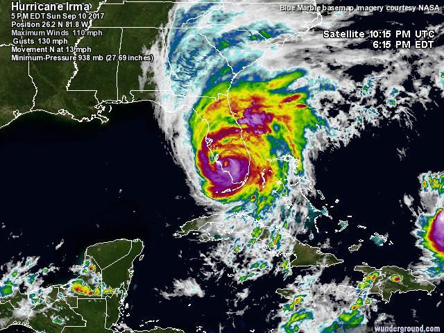
2 Atlantic Basin Satellite Image
3

4 State radar as of 05:05pm EDT Sunday

5 Future Radar 12am Tonight

6 Future Radar 6am Tomorrow
7
8
9

10 Tallahassee 9% Jacksonville 9% Orlando 8% Tampa 86%
11 hurrevac

12 Zoomable, interactive map: office=mfl#
13
14
15
16


17 9am Monday 6am Monday 12am Monday 6pm Sunday


18 9pm Monday 6pm Monday 12pm Monday 6am Monday 3am Monday

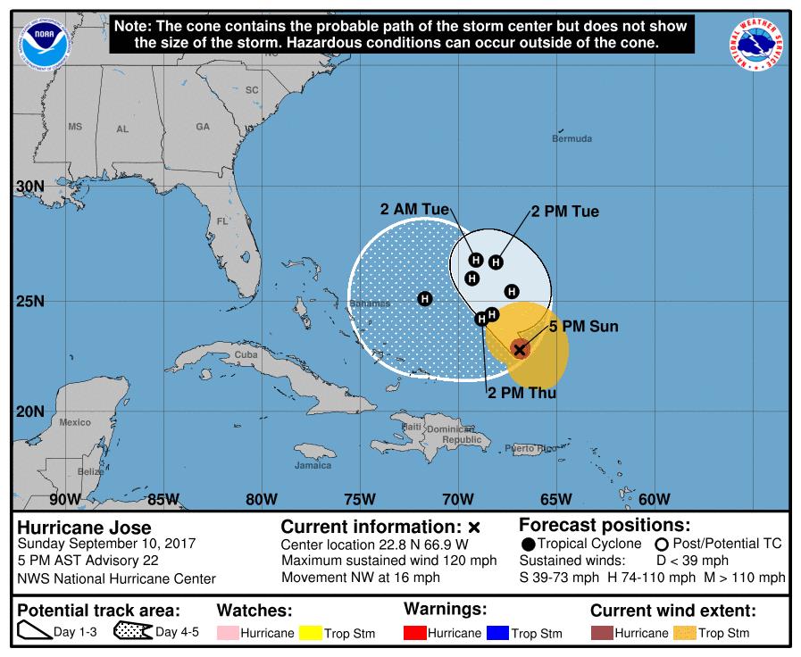
19 Storm Surge Warning Zoomable maps available here: refresh/graphics_at1+shtm l/ shtml?wsurge#c ontents Probabilistic Storm Surge /psurge2.0/index.php?s=ir ma2017&adv=34&ty=e10 &Z=z4&D=agl&Ti=cum&M sg=17&help=about

20 Above Normally Dry Ground

21 Additional rainfall still to come over the next 24 hours. Localized heavy amounts possible.

22 Flash Flood Watches for the Entire Peninsula and much of the Big Bend River Flood Warnings for Early Next Week Based on Expected Rainfall Numerous Areal Flood Warnings with the occasional Flash Flood Warning can be expected overnight as rain continue, especially in Central and Northeast Florida.

23 Extensive river flooding expected across much of the Florida Peninsula

24 Tornado threat will continue this evening for Central Florida, and increase in Northeast Florida tomorrow. Additional tornado watches are expected for Central and Northeast Florida.

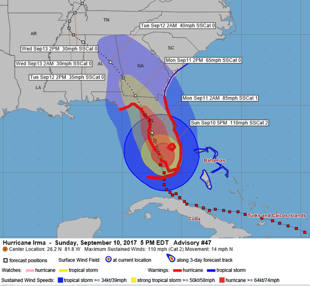
25 Tornado Watch in Effect

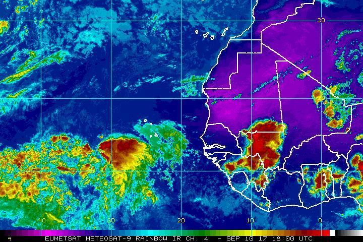
26 Hurricane Jose Infrared Satellite Image
27

28 Models are very spread out, but generally show Jose stalling and completing a loop before continuing to the north or northwest later this week.

29 Jose will continue to weaken thanks to wind shear from Hurricane Irma.


30 * Formation chance through 48 hours...low...30 percent. * Formation chance through 5 days medium...60 percent.
31
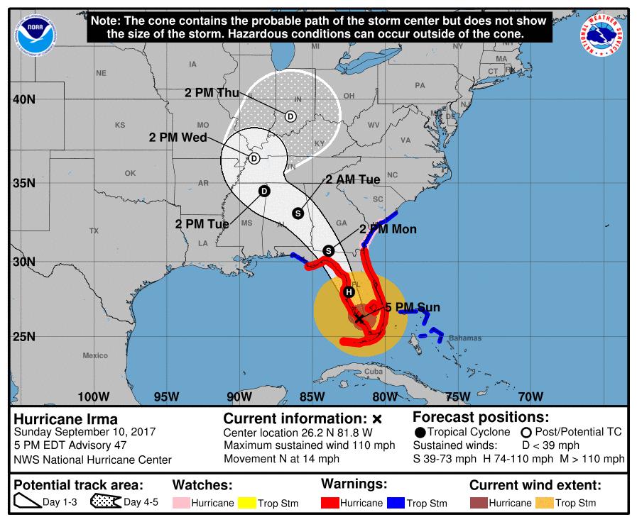
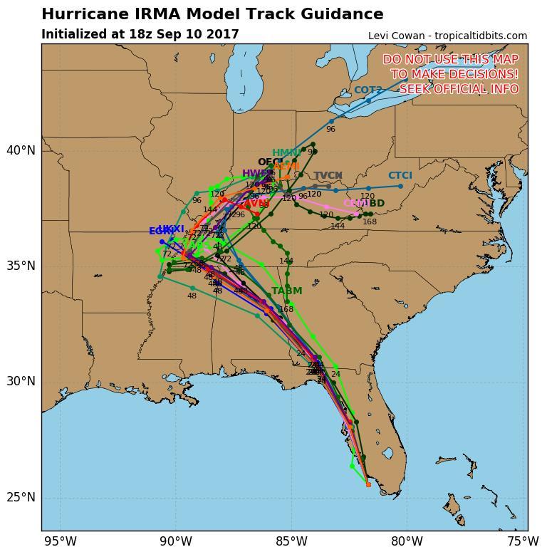
32 Summary At 5pm EDT Sunday, Hurricane Irma was moving north at 14 mph with maximum sustained winds of 110 mph, making Irma a category 2 storm on the Saffir-Simpson hurricane wind scale. Irma is expected to be a category 1 Storm as it enters the Central Florida regions with sustained winds of a category 1 but will see category 2 gusts. Land interaction will continue to weaken the system. On the current forecast track, Irma is entering Naples and moving North in Tampa by later this evening and will move into the big bend and the south Georgia by Monday afternoon. The forecast track moved slightly northward and eastward in this advisory as Irma has made landfall in Naples Florida and is moving due north. Tropical Storm force winds expected throughout most of the state through tomorrow. At 5pm EDT Saturday, Hurricane Jose was located near latitude 22.8 North, Longitude 66.9 West moving Northwest at 16 mile per hour. This is well north of the Leeward Islands. Maximum sustained winds are near 120mph, which is a Category 3 on the Saffir-Simpson Hurricane Wind Scale. Jose has weakened but is expected to remain a hurricane continuing to move to the northwest slowly and beginning to turn toward the northeast Monday night. Shower and thunderstorm activity associated with a tropical wave located several hundred miles southwest of the Cabo Verde Islands has shown signs of organization. Environmental conditions are expected to support at least some additional development, and a there is a 60% chance that a tropical depression could form in a few days while the system moves generally northwestward over the eastern Atlantic Ocean.
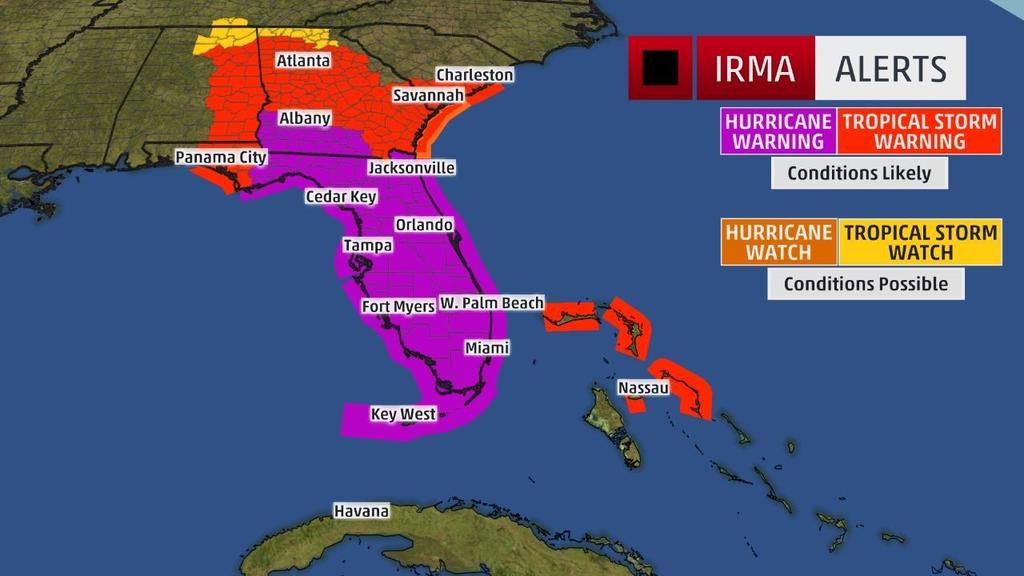
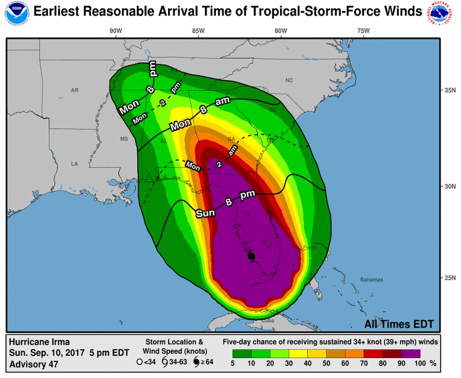
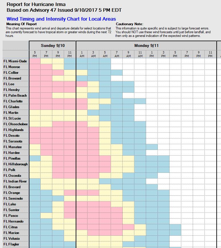
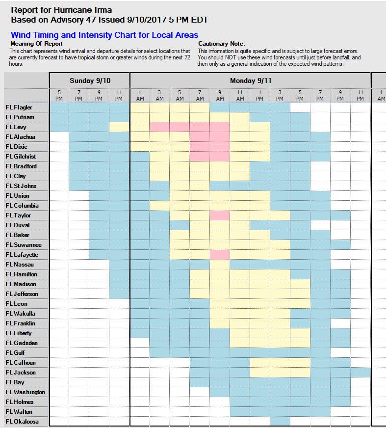
33 Florida Outlook Nearly all of the Florida Peninsula and Florida Panhandle will continue to feel impacts from this system. A Hurricane Warning is now in effect for all Florida counties east of a the Apalachicola River, including Lake Okeechobee and Florida Bay. A Storm Surge Warning is now in effect from the Ochlockonee River southward around the Florida Peninsula to North Miami Beach and from Jupiter Inlet to Fernandina Beach, including the Florida Keys and Tampa Bay. A Tropical Storm Warning is in effect for Bay, Calhoun, Gulf, Holmes, Jackson, Walton, and Washington counties. Rainfall amounts could reach as high as with isolated higher totals of 20 possible in the Peninsula. Lesser amounts of 4-9 are expected in the Big Bend and less than that in the Panhandle. Flash Flood Watches are in effect for the entire Peninsula and Big Bend. Significant river flooding is expected in the coming days in many rivers of Central and Southwest FL. Some river flooding is also now expected in Northeast Florida and the eastern Big Bend. Life-threatening storm surge will be impacting the West Coast of Florida today, especially SW FL. Isolated tornadoes are possible in the outer bands of Irma and will spread northward tonight and tomorrow. A Tornado Watch is in effect for Central and Northeast Florida, with additional tornado watches possible into Northeast Florida tomorrow. Hurricane Jose does not pose a threat to Florida within the next 5-7 days, but should be monitored. Another briefing packet will be issued Monday Morning. For more information, visit the NHC website at
34 Tropical Update Created by: Michael Spagnolo, Deputy State Meteorologist State Meteorological Support Unit Florida Division of Emergency Management Users wishing to subscribe (approval pending) to this distribution list, register at Other reports available for subscription are available at
Tropical Update. 5 PM EDT Thursday, September 7, 2017 Hurricane Irma, Hurricane Jose, and Hurricane Katia
 Tropical Update 5 PM EDT Thursday, September 7, 2017 Hurricane Irma, Hurricane Jose, and Hurricane Katia This update is intended for government and emergency response officials, and is provided for informational
Tropical Update. 5 AM EDT Tuesday, September 12, 2017 Post-Tropical Cyclone Irma, Hurricane Jose, & Tropical Wave (10%)
") Tropical Update 5 AM EDT Tuesday, September 12, 2017 Post-Tropical Cyclone Irma, Hurricane Jose, & Tropical Wave (10%) This update is intended for government and emergency response officials, and is provided
Tropical Update 5 AM EDT Tuesday, September 12, 2017 Post-Tropical Cyclone Irma, Hurricane Jose, & Tropical Wave (10%) This update is intended for government and emergency response officials, and is provided
Tropical Update. 11 AM EDT Tuesday, October 9, 2018 Hurricane Michael, Tropical Storm Leslie, Tropical Storm Nadine
 Tropical Update 11 AM EDT Tuesday, October 9, 2018 Hurricane Michael, Tropical Storm Leslie, Tropical Storm Nadine This update is intended for government and emergency response officials, and is provided
Tropical Update. 5 AM EDT Thursday, September 7, 2017 Hurricane Irma, Hurricane Jose, and Hurricane Katia
 Tropical Update 5 AM EDT Thursday, September 7, 2017 Hurricane Irma, Hurricane Jose, and Hurricane Katia This update is intended for government and emergency response officials, and is provided for informational
Tropical Update. 5 AM EDT Monday, October 8, 2018 Tropical Storm Michael, Tropical Storm Leslie, Invest 92L (10%) & African Tropical Wave (50%)
 & African Tropical Wave (50%)") Tropical Update 5 AM EDT Monday, October 8, 2018 Tropical Storm Michael, Tropical Storm Leslie, Invest 92L (10%) & African Tropical Wave (50%) This update is intended for government and emergency response
Tropical Update 5 AM EDT Monday, October 8, 2018 Tropical Storm Michael, Tropical Storm Leslie, Invest 92L (10%) & African Tropical Wave (50%) This update is intended for government and emergency response
Tropical Update. 5 AM EDT Wednesday, September 6, 2017 Hurricane Irma, Tropical Storm Jose, and Tropical Storm Katia
 Tropical Update 5 AM EDT Wednesday, September 6, 2017 Hurricane Irma, Tropical Storm Jose, and Tropical Storm Katia This update is intended for government and emergency response officials, and is provided
Tropical Update. 5 PM EDT Sunday, October 7, 2018 Tropical Storm Michael, Tropical Storm Leslie, & Invest 92L (30%)
") Tropical Update 5 PM EDT Sunday, October 7, 2018 Tropical Storm Michael, Tropical Storm Leslie, & Invest 92L (30%) This update is intended for government and emergency response officials, and is provided
Tropical Update 5 PM EDT Sunday, October 7, 2018 Tropical Storm Michael, Tropical Storm Leslie, & Invest 92L (30%) This update is intended for government and emergency response officials, and is provided
Tropical Update. 11 AM EDT Wednesday, October 10, 2018 Hurricane Michael, Hurricane Leslie & Tropical Storm Nadine, Caribbean Low (40%)
") Tropical Update 11 AM EDT Wednesday, October 10, 2018 Hurricane Michael, Hurricane Leslie & Tropical Storm Nadine, Caribbean Low (40%) This update is intended for government and emergency response officials,
Tropical Update 11 AM EDT Wednesday, October 10, 2018 Hurricane Michael, Hurricane Leslie & Tropical Storm Nadine, Caribbean Low (40%) This update is intended for government and emergency response officials,
Tropical Update. 5 PM EDT Tuesday, September 5, 2017 Hurricane Irma, Tropical Storm Jose, and Tropical Depression Thirteen
 Tropical Update 5 PM EDT Tuesday, September 5, 2017 Hurricane Irma, Tropical Storm Jose, and Tropical Depression Thirteen This update is intended for government and emergency response officials, and is
Tropical Update. 12 PM EDT Friday, October 7, 2016 Hurricane Matthew & Tropical Storm Nicole
 Tropical Update 12 PM EDT Friday, October 7, 2016 Hurricane Matthew & Tropical Storm Nicole This update is intended for government and emergency response officials, and is provided for informational and
Tropical Update 11 AM EDT Thursday, September 6, 2018 Tropical Depression Gordon, Hurricane Florence, Invest 92L (90%) & African Tropical Wave (50%)
 & African Tropical Wave (50%)") Tropical Update 11 AM EDT Thursday, September 6, 2018 Tropical Depression Gordon, Hurricane Florence, Invest 92L (90%) & African Tropical Wave (50%) This update is intended for government and emergency
Tropical Update 11 AM EDT Thursday, September 6, 2018 Tropical Depression Gordon, Hurricane Florence, Invest 92L (90%) & African Tropical Wave (50%) This update is intended for government and emergency
Tropical Update 6 AM EDT Friday, October 7, 2016 Hurricane Matthew & Hurricane Nicole
 Tropical Update 6 AM EDT Friday, October 7, 2016 Hurricane Matthew & Hurricane Nicole This update is intended for government and emergency response officials, and is provided for informational and situational
Atlantic Basin Satellite Image
 Tropical Update 11 AM EDT Friday, September 7, 2018 Tropical Depression Gordon, Tropical Storm Florence, Potential Tropical Cyclone #8 (90%), Invest 92L (90%) This update is intended for government and
Tropical Update. 1 PM EDT Monday, May 21, 2018 Caribbean Disturbance (20%)
") Tropical Update 1 PM EDT Monday, May 21, 2018 Caribbean Disturbance (20%) This update is intended for government and emergency response officials, and is provided for informational and situational awareness
Tropical Update 1 PM EDT Monday, May 21, 2018 Caribbean Disturbance (20%) This update is intended for government and emergency response officials, and is provided for informational and situational awareness
Tropical Update. 5 PM EDT Thursday, August 27, 2015 Tropical Storm Erika
 Tropical Update 5 PM EDT Thursday, August 27, 2015 Tropical Storm Erika This update is intended for government and emergency response officials, and is provided for informational and situational awareness
Hurricane Irma Page 1 HURRTRAK RM/Pro 2017 Summary Report for Tampa, FL 09/10/ EDT, Adv. # 46
 Hurricane Irma Page 1 Description of impact to Tampa, FL, Tampa, FL, is expected to receive a major impact from Hurricane Irma. The forecast maximum wind for this location has increased since the last
GC Briefing. Weather Sentinel Tropical Storm Michael. Status at 8 AM EDT (12 UTC) Today (NHC) Discussion. October 11, 2018
 Today (NHC) Discussion. October 11, 2018") GC Briefing Weather Sentinel Tropical Storm Michael October 11, 2018 After making landfall as a high-end category-4 hurricane on the Florida Panhandle, Michael weakened to tropical storm status early this
GC Briefing Weather Sentinel Tropical Storm Michael October 11, 2018 After making landfall as a high-end category-4 hurricane on the Florida Panhandle, Michael weakened to tropical storm status early this
Hurricane Irma Page 1 HURRTRAK RM/Pro 2017 Summary Report for Tampa, FL 09/09/ EDT, Adv. # 43
 Hurricane Irma Page 1 Description of impact to Tampa, FL, Tampa, FL, is expected to receive a major impact from Hurricane Irma. The forecast maximum wind for this location has decreased since the last
WEDNESDAY 30 TH AUGUST, :57 p.m. Tropical Storm Irma forms in the Atlantic. Don t let your guard down, always #Be Ready.
 Chapter 1 - The Set Up In the days leading up to Irma a series of composed and sobering text messages, presented in truncated form below, from Department of Disaster Management warned us of the pending
TROPICAL STORM HARVEY BRIEFING
 TROPICAL STORM HARVEY BRIEFING 10:00 AM CDT Sunday, August 27, 2017 Prepared by: NWS LIX NWSNewOrleans www.weather.gov/neworleans Situation Overview New Information Tropical Storm Winds 40mph Immediate
GC Briefing. Weather Sentinel Hurricane Florence. Status at 5 PM EDT (21 UTC) Today (NHC) Discussion. September 13, 2018
 Today (NHC) Discussion. September 13, 2018") GC Briefing September 13, 2018 Weather Sentinel Hurricane Florence Tropical storm conditions have been reported for areas of North Carolina and will continue to spread inland to the west and south. Hurricane
GC Briefing September 13, 2018 Weather Sentinel Hurricane Florence Tropical storm conditions have been reported for areas of North Carolina and will continue to spread inland to the west and south. Hurricane
Hurricane Matthew. Life Threatening Flash Flooding Likely. National Weather Service Wilmington NC. Josh Weiss, Meteorologist
 Hurricane Matthew Life Threatening Flash Flooding Likely Threat Assessment for northeast South Carolina & southeast North Carolina National Weather Service Wilmington NC 630 PM EDT Friday October 7, 2016
Current Details from the National Hurricane Center (NHC)
") Current Watches and Warnings A Warning is in effect from Anclote River to the Okaloosa/Walton County Line; north of the Volusia/Brevard County line to the South Santee River A Surge Warning is in effect
Current Watches and Warnings A Warning is in effect from Anclote River to the Okaloosa/Walton County Line; north of the Volusia/Brevard County line to the South Santee River A Surge Warning is in effect
HURRICANE HARVEY COE Navigation BRIEFING
 HURRICANE HARVEY COE Navigation BRIEFING 10:00 AM CDT Friday, August 25, 2017 NWSNewOrleans www.weather.gov/neworleans Situation Overview New Information Harvey continues to strengthen Max sustained winds
Hurricane Matthew Life Threatening Flash Flooding Likely
 Hurricane Matthew Life Threatening Flash Flooding Likely Threat Assessment for northeast South Carolina & southeast North Carolina National Weather Service Wilmington NC 12 AM EDT Saturday October 8, 2016
Major Hurricane Matthew Briefing Situation Overview
 Major Hurricane Matthew Briefing Situation Overview At 5 p.m. Tuesday, Category 4 Hurricane Matthew was about 860 miles South-Southeast of Mayport, Florida, moving north around 10 mph. Maximum sustained
HURRICANE IRMA. 12 PM ET Saturday, September Prepared by: Kyle Thiem / Sid King.
 HURRICANE IRMA 12 PM ET Saturday, September 9 2017 Prepared by: Kyle Thiem / Sid King www.weather.gov/atlanta/briefings @NWSAtlanta www.weather.gov/atlanta Situation Overview 11:00 AM EDT Sat Sep 9 Location:
Current Details from the National Hurricane Center (NHC)
") Current Watches and Warnings A Hurricane Warning is in effect from Fernandina Beach southward around the Florida peninsula to Indian Pass; Florida Keys; Lake Okeechobee; Florida Bay A Hurricane Watch is
Current Watches and Warnings A Hurricane Warning is in effect from Fernandina Beach southward around the Florida peninsula to Indian Pass; Florida Keys; Lake Okeechobee; Florida Bay A Hurricane Watch is
Wind field has expanded and is very large. Hurricane Wind field = 100 miles wide, Tropical Storm Wind field = 360 miles wide
 HURRICANE IRMA 12 PM ET Sunday, September 10 2017 Prepared by: Keith Stellman / Kyle Thiem www.weather.gov/atlanta/briefings @NWSAtlanta www.weather.gov/atlanta Situation Overview 11:10 AM EDT Sun Sep
Tropical Storm Colin Briefing Last Briefing on this System
 Tropical Storm Colin Briefing Last Briefing on this System NWS WFO Jacksonville, Florida Tuesday, June 07, 2016 6:00 a.m. EDT Tropical Storm Colin s Impacts SE Georgia & North Florida Local Watches & Warnings:
Storm Summary for Hurricane Jose
 Storm Summary for Hurricane Jose Tuesday, September 19, 2017 at 11 AM EDT (Output from Hurrevac, based on National Hurricane Center Forecast Advisory #57) Jose is currently a Category 1 hurricane on the
TROPICAL STORM NATE BRIEFING
 TROPICAL STORM NATE BRIEFING 5:00 AM CDT Friday, October 6, 2017 Prepared by: NWS NWSNewOrleans www.weather.gov/neworleans Situation Overview No significant changes to the track forecast this morning.
Tropical Storm Harvey: SE Texas Impacts
 Tropical Storm Harvey: SE Texas Impacts 10 AM CDT UPDATE Thursday, August 24, 2017 Prepared by: Dan Reilly, Brian Kyle PLEASE MUTE YOUR LINES AND DON T PUT ON HOLD! Situation Overview Tropical Storm Harvey
TROPICAL STORM HARVEY COE Navigation Call - Update
 TROPICAL STORM HARVEY COE Navigation Call - Update 10:00 AM CDT Tuesday, August 29, 2017 Prepared by: NWS LIX NWSNewOrleans www.weather.gov/neworleans Situation Overview New Information Drifting ENE at
National Hurricane Center Products. Jack Beven National Hurricane Center
 National Hurricane Center Products Jack Beven National Hurricane Center Florida Governor s Hurricane Conference 11 May 2014 NHC Tropical Cyclone Products NHC provides the big picture that complements and
Hurricane Harvey: SE Texas Impacts. 10 AM CDT UPDATE Saturday, August 26, 2017 Prepared by: Dan Reilly, Brian Kyle
 Hurricane Harvey: SE Texas Impacts 10 AM CDT UPDATE Saturday, August 26, 2017 Prepared by: Dan Reilly, Brian Kyle Latest Observations and Radar Hurricane Harvey centered near Victoria and weakening Wind
Current Details from the National Hurricane Center (NHC)
") Current Watches and Warnings A Hurricane Warning is in effect from Fernandina Beach southward around the Florida peninsula to the Indian Pass; Florida Keys; Lake Okeechobee; Florida Bay; Cuban provinces
Current Watches and Warnings A Hurricane Warning is in effect from Fernandina Beach southward around the Florida peninsula to the Indian Pass; Florida Keys; Lake Okeechobee; Florida Bay; Cuban provinces
HURRICANE IRENE. CONFERENCE CALL BRIEFING SLIDES Saturday August 27, :30 AM
 HURRICANE IRENE CONFERENCE CALL BRIEFING SLIDES Saturday August 27, 2011 8:30 AM NHC TRACK AND CONE HURRICANE IRENE WATCHES/WARNINGS Hurricane Warning along south coast including all of Cape Cod and Islands
Storm Summary for Hurricane Joaquin
 Storm Summary for Hurricane Joaquin Wednesday, September 30, 2015 at 5 PM EDT (Output from Hurrevac, based on National Hurricane Center Forecast Advisory #12) Joaquin is currently a Category 1 hurricane
Hurricane Matthew Page 1 Location Forecast Analysis Summary Report - Advanced Wind Estimation On
 Page 1 Current NHC Forecast Predictions Maximum Sustained Winds / Storm Category: 138 MPH / Category 4 Forward motion: 9 mph towards the North Hurricane Force winds extend from the center: 46 miles Tropical
Major Hurricane Earl
 Major Hurricane Earl Advisory 32 North Carolina Threat Assessment Prepared at: 8 AM Thursday September 2, 2010 Hurricane and Tropical Storm Warnings in effect for the North Carolina Coast and Sounds. NWS
Florida Division of Emergency Management State Watch Office
 Florida Division of Emergency Management State Watch Office Morning Situation Report Monday, October 8, 2018 State Emergency Operations Center Activation Level Level 1 Activation SERT On-Call Personnel
Current Details from the National Hurricane Center (NHC)
") Current Watches and Warnings A Hurricane Warning is in effect from Fernandina Beach southward around the Florida peninsula to the Aucilla River; Florida Keys; Lake Okeechobee; Florida Bay; Cuban provinces
Current Watches and Warnings A Hurricane Warning is in effect from Fernandina Beach southward around the Florida peninsula to the Aucilla River; Florida Keys; Lake Okeechobee; Florida Bay; Cuban provinces
Storm Surge Forecast with Shifting Forecast Tracks
 Storm Surge Forecast with Shifting Forecast Tracks Storm Surge Findings in the Florida Keys Jon Rizzo Warning Coordination Meteorologist National Weather Service Florida Keys Florida Keys Life History
Florida Division of Emergency Management State Watch Office
 Florida Division of Emergency Management State Watch Office Morning Situation Report Wednesday, October 24, 2018 State Emergency Operations Center Activation Level Level 2 Activation SERT On-Call Personnel
NOAA s National Weather Service Philadelphia/Mt. Holly NJ
 Next Briefing Package: Friday, October 2, 2015 no later than 300 PM Hazards and Impacts: Overview: A dangerous weather pattern still threatens our region. Threats include very heavy rainfall, inland river
Tropical Storm Ana. Created 6:00 AM Sun May 10, 2015 John Cole Warning Coordination Meteorologist
 Tropical Storm Ana Threat Assessment for Eastern North Carolina Created 6:00 AM Sun May 10, 2015 John Cole Warning Coordination Meteorologist John.cole@noaa.gov National Weather Service Newport/Morehead
Friday, September 7, :30 a.m. EDT
 Friday, September 7, 2018 8:30 a.m. EDT Tropical Depression Gordon - Final Situation (Advisory #20 as of 5:00 a.m. EDT) Located 30 miles S of Little Rock, AR Moving N at 5 mph; this motion expected to
Current Details from the National Hurricane Center (NHC)
") Current Watches and Warnings A Hurricane Warning is in effect for Dominican Republic from Cabo Engano to the northern border with Haiti; Haiti from the northern border with the Dominican Republic to Le
Current Watches and Warnings A Hurricane Warning is in effect for Dominican Republic from Cabo Engano to the northern border with Haiti; Haiti from the northern border with the Dominican Republic to Le
HURRICANE NATE BRIEFING
 HURRICANE NATE BRIEFING 2:00 PM CDT Saturday, October 07, 2017 Prepared by: NWS NWSNewOrleans www.weather.gov/neworleans Situation Overview continues to intensify. It is now forecast to be a category 2
Florida Division of Emergency Management State Watch Office
 Florida Division of Emergency Management State Watch Office Morning Situation Report Wednesday, November 7, 2018 State Emergency Operations Center Activation Level Level 2 Activation SERT On-Call Personnel
TROPICAL STORM HARVEY BRIEFING
 TROPICAL STORM HARVEY BRIEFING 2:00 PM CDT Tuesday, August 29, 2017 Prepared by: NWS LIX NWSNewOrleans www.weather.gov/neworleans Situation Overview New Information Moving NNE Max sustained wind 45 mph
Florida Division of Emergency Management State Watch Office
 Florida Division of Emergency Management State Watch Office Morning Situation Report Monday, October 1, 2018 State Emergency Operations Center Activation Level Level 3 Monitoring SERT On-Call Personnel
Hurricane Sandy October 28 th 31 st 2012
 Hurricane Sandy October 28 th 31 st 2012 Prepared 530 PM EDT Saturday October 27, 2012 Gary Szatkowski NOAA s NJ Forecast Office Weather.gov/phi Purpose of Briefing Briefing #7 for event Promote situational
Tropical Weather Briefing
 Tropical Weather Briefing August 28, 2012 700 AM CDT National Weather Service Weather Forecast Office Slidell, LA Current Satellite Tropical Storm Isaac Watches/Warnings Tropical Storm Isaac Track Guidance
RSMC-Miami Update Daniel Brown Warning Coordination Meteorologist
 RSMC-Miami Update 2016 Daniel Brown Warning Coordination Meteorologist L-0324 Emergency Management Hurricane Preparedness Training Course Funding provided by FEMA s National Hurricane Program - partnership
Current Details from the National Hurricane Center (NHC)
") Current Watches and Warnings A Hurricane Warning is in effect for Dominican Republic from Cabo Engano to the northern border with Haiti; Haiti from the northern border with the Dominican Republic to Le
Current Watches and Warnings A Hurricane Warning is in effect for Dominican Republic from Cabo Engano to the northern border with Haiti; Haiti from the northern border with the Dominican Republic to Le
Major Hurricane Matthew Briefing Situation Overview
 Major Hurricane Matthew Briefing Situation Overview THIS IS NOW A WORST CASE STORM SURGE SCENARIO Catastrophic Damage is Anticipated for Coastal Areas. Major Hurricane Matthew is still expected to move
Saturday, October 6, :30 a.m. EDT
 Saturday, October 6, 2018 8:30 a.m. EDT Significant Activity Oct 5-6 Significant Events: None Tropical Activity: Atlantic Tropical Storm Leslie; Disturbance 1 (High: 90%) Eastern Pacific Hurricane Sergio
Significant Flooding Expected
 Significant Flooding Expected Decision Support Briefing #5 As of: 9:00 AM September 14, 2018 What Has Changed? Flash Flood Watch now in effect for part of area, will be expanded later today 9/14/2018 9:23
Hurricane Harvey: SE Texas Impacts. 10 PM CDT UPDATE Friday, August 25, 2017 Prepared by: Lance Wood
 Hurricane Harvey: SE Texas Impacts 10 PM CDT UPDATE Friday, August 25, 2017 Prepared by: Lance Wood Latest Observations Hurricane Harvey making landfall this evening near Rockport as a category 4 hurricane.
Major Hurricane Earl
 Major Hurricane Earl Advisory 33 North Carolina Threat Assessment Prepared at: 11 AM Thursday September 2, 2010 Hurricane and Tropical Storm Warnings in effect for the North Carolina Coast and Sounds NWS
Tropical Storm Ana. Created 615 AM Sat May 9, 2015 Reid Hawkins, Science Officer
 Tropical Storm Ana Threat Assessment for northeast South Carolina & southeast North Carolina Created 615 AM Sat May 9, 2015 Reid Hawkins, Science Officer National Weather Service Wilmington, NC 1 New Information
What s s New for 2009
 What s s New for 2009 Graphical Tropical Weather Outlook becomes operational Special Tropical Disturbance Statement replaced with Special Tropical Weather Outlook Tropical Cyclone Wind Field Graphic becomes
photo courtesy of
 BRITISH VIRGIN ISLANDS REPORT TROPICAL STORM JEANNE photo courtesy of www.bviplatinum.com PREPARED BY THE DEPARTMENT OF DISASTER MANAGEMENT 1 EVENT 13 th -16 th September, 2004 TROPICAL STORM JEANNE Sequence
Outlook 2008 Atlantic Hurricane Season. Kevin Lipton, Ingrid Amberger National Weather Service Albany, New York
 Outlook 2008 Atlantic Hurricane Season Kevin Lipton, Ingrid Amberger National Weather Service Albany, New York Summary 2007 Hurricane Season Two hurricanes made landfall in the Atlantic Basin at category-5
National Situation Report As of 3:00 a.m. EDT, Thursday, September 21, 2017 Table of Contents Current Operations Monitoring Recovery
 25k Overview National Situation Report As of 3:00 a.m. EDT, Thursday, September 21, 2017 Table of Contents Current Operations Monitoring Recovery FEMA Headquarters Status FEMA Region Status NRCC Level
Satellite and Radar. 5:55 am Infrared Satellite with Surface Wind Arrows. 6:15 am Ruskin Doppler Radar. Large southerly wind field
 Satellite and Radar 5:55 am Infrared Satellite with Surface Wind Arrows 6:15 am Ruskin Doppler Radar Large southerly wind field Developing showers rotating onshore NHC Forecast Hurricane Warning Big Bend
Frank Revitte National Weather Service. Weather Forecast Office New Orleans/Baton Rouge
 Frank Revitte National Weather Service Weather Forecast Office New Orleans/Baton Rouge Above normal activity 17 Total Named Storms 7 Tropical Storms 4 Hurricanes 6 Major Hurricanes Not the most active,
TROPICAL STORM NATE BRIEFING
 TROPICAL STORM NATE BRIEFING 10:30 AM CDT Friday, October 06, 2017 Prepared by: NWS NWSNewOrleans www.weather.gov/neworleans Situation Overview Track forecast has shifted slightly eastward. Hurricane Watch
Florida Division of Emergency Management State Watch Office
 Florida Division of Emergency Management State Watch Office Morning Situation Report Sunday, December 9, 2018 State Emergency Operations Center Activation Level Level 3 Monitoring SERT On-Call Personnel
Very Dangerous Coastal Storm Sandy October 28 th 31 st 2012
 Very Dangerous Coastal Storm Sandy October 28 th 31 st 2012 Prepared 600 PM EDT Monday October 29, 2012 Gary Szatkowski NOAA s NJ Forecast Office Weather.gov/phi Purpose of Briefing Briefing #11 for event
Florida Division of Emergency Management State Watch Office
 Florida Division of Emergency Management State Watch Office Morning Situation Report Sunday, January 13, 2019 State Emergency Operations Center Activation Level Level 3 Monitoring SERT On-Call Personnel
Florida Division of Emergency Management State Watch Office
 Florida Division of Emergency Management State Watch Office Morning Situation Report Saturday, December 1, 2018 State Emergency Operations Center Activation Level Level 3 Monitoring SERT On-Call Personnel
SITUATION REPORT #7 September 8 th, 2017
 MCO AIRPORT EMERGENCY OPERATIONS CENTER SITUATION REPORT #7 September 8 th, 2017 STATE OF FLORIDA REGION V FEMA REGION IV GENERAL INFORMATION Local State of Emergency Declaration Number: 17-235 Dated:
Monday, October 8, :30 a.m. EDT
 Monday, October 8, 2018 8:30 a.m. EDT Significant Activity Oct 7-8 Significant Events: Tropical Storm Michael Preparation Tropical Activity: Atlantic Tropical Storm Leslie; Tropical Storm Michael; Disturbance
Florida Division of Emergency Management State Watch Office
 Florida Division of Emergency Management State Watch Office Morning Situation Report Saturday, January 19, 2019 State Emergency Operations Center Activation Level Level 3 Monitoring SERT On-Call Personnel
Overview of Current Tropical Cyclone Products Generated by NWS
 Overview of Current Tropical Cyclone Products Generated by NWS Todd B. Kimberlain National Hurricane Center HFIP Ensembles Workshop Boulder, Colorado 20 April 2010 National Weather Service hurricane forecast
Subtropical Storm Ana
 Subtropical Storm Ana Threat Assessment for northeast South Carolina & southeast North Carolina Created 745 AM Fri May 8, 2015 Reid Hawkins, Science Officer National Weather Service Wilmington, NC 1 New
NOAA s National Weather Service Philadelphia/Mt. Holly NJ
 Next Briefing Package: Thursday, October 1, 2015 no later than 300 PM Hazards and Impacts: Overview: A dangerous weather pattern is developing for our region. Threats include very heavy rainfall, inland
Heavy Rain and Potential for Dangerous Flooding for northeast SC and southeast NC
 US National Weather Service Wilmington NC @NWSWilmingtonNC http://weather.gov/ilm ***Life Threatening Flooding Possible*** Heavy Rain and Potential for Dangerous Flooding for northeast SC and southeast
Florida Division of Emergency Management State Watch Office
 Florida Division of Emergency Management State Watch Office Morning Situation Report Wednesday, November 21, 2018 State Emergency Operations Center Activation Level Level 3 Monitoring SERT On-Call Personnel
Tropical Storm Harvey: SE Texas Impacts. 10 AM CDT UPDATE Sunday August 27, 2017 Prepared by: Lance Wood
 Tropical Storm Harvey: SE Texas Impacts 10 AM CDT UPDATE Sunday August 27, 2017 Prepared by: Lance Wood Situation Overview Catastrophic flooding is ongoing with flash flood emergencies remaining in effect.
TROPICAL CYCLONE TORNADOES
 TROPICAL CYCLONE TORNADOES 2018 GOVERNOR S HURRICANE CONFERENCE TUESDAY, MAY 15, 2018 WILL ULRICH NWS FORECAST OFFICE MELBOURNE WHERE ARE THE TORNADOES? WHERE ARE THE TORNADOES? C B A WEST MELBOURNE, FL
Hurricane Michael Analysis
 10.10.18 Analysis Risk Services Division Legal Notice All consulting services performed by HUB are advisory in nature. All resultant reports are based upon conditions and practices observed by HUB and
Hurricane Matthew. National Weather Service Wilmington NC. Steven Pfaff, WCM.
 Hurricane Matthew Threat Assessment for northeast South Carolina & southeast North Carolina National Weather Service Wilmington NC 515 PM EDT Monday October 3, 2016 Steven Pfaff, WCM Steven.Pfaff@noaa.gov
TROPICAL STORM NATE BRIEFING
 TROPICAL STORM NATE BRIEFING 2:00 PM CDT Friday, October 06, 2017 Prepared by: NWS NWSNewOrleans www.weather.gov/neworleans Situation Overview Track forecast has not changed since the 10 am advisory. Hurricane
Current Details from the National Hurricane Center (NHC)
") Current Watches/Warnings A Hurricane Warning is in effect from Surf City, North Carolina to the North Carolina/Virginia border; Pamlico Sound; Eastern Albemarle Sound A Hurricane Watch is in effect from
Current Watches/Warnings A Hurricane Warning is in effect from Surf City, North Carolina to the North Carolina/Virginia border; Pamlico Sound; Eastern Albemarle Sound A Hurricane Watch is in effect from
Current Details from the National Hurricane Center (NHC)
") Current Watches and Warnings A Warning is in effect from South Santee River, South Carolina to Cape Lookout, North Carolina; Pamlico Sound A Surge Warning is in effect from Myrtle Beach, South Carolina
Current Watches and Warnings A Warning is in effect from South Santee River, South Carolina to Cape Lookout, North Carolina; Pamlico Sound A Surge Warning is in effect from Myrtle Beach, South Carolina
MIAMI-SOUTH FLORIDA National Weather Service Forecast Office
 MIAMI-SOUTH FLORIDA National Weather Service Forecast Office http://www.weather.gov/miami June 2015 South Florida Weather Summary Dry East, Wet West...Drought Remains SE Florida July 3, 2015: Depending
6:00 am August 3, 2015 Heavy Rain & Coastal Flood Update
 6:00 am August 3, 2015 Heavy Rain & Coastal Flood Update Synopsis/Overview: An area of low pressure spinning over the northeast Gulf of Mexico off the Nature Coast will continue to provide the threat for
NWS SERFC Hydrologic Vulnerability Assessment. Monday, March 9 th, 2015 NOAA, National Weather Service Southeast River Forecast Center
 NWS SERFC Hydrologic Vulnerability Assessment Monday, March 9 th, 2015 NOAA, National Weather Service Southeast River Forecast Center Current Weather Map Today s weather map shows a blossoming system in
Weather briefing Strong Coastal Nor easter November 7 th -8 th, 2012
 Weather briefing Strong Coastal Nor easter November 7 th -8 th, 2012 Prepared 1245 PM EDT Tuesday November 6, 2012 Gary Szatkowski NOAA s NJ Forecast Office Weather.gov/phi Purpose of Briefing Briefing
NWS HURRICANES June 3, 2015
 NWS HURRICANES June 3, 2015 Hurricane Season June 1 November 30 2 What s the concern? All tropical systems passing within 125nm of central Maryland since 1950 Mid-Atlantic Hurricanes Greatest Risk: August
Florida Division of Emergency Management State Watch Office
 Florida Division of Emergency Management State Watch Office Morning Situation Report Wednesday, January 23, 2019 State Emergency Operations Center Activation Level Level 3 Monitoring SERT On-Call Personnel
Current Details from the National Hurricane Center (NHC)
") Current Watches and Warnings A Hurricane Warning is in effect from Port Mansfield to Sargent, Texas A Warning is in effect from north of Sargent to High Island, Texas; south of Port Mansfield, Texas to
Current Watches and Warnings A Hurricane Warning is in effect from Port Mansfield to Sargent, Texas A Warning is in effect from north of Sargent to High Island, Texas; south of Port Mansfield, Texas to
TROPICAL DEPRESSION HARVEY BRIEFING
 TROPICAL DEPRESSION HARVEY BRIEFING 10:15 PM CDT Wednesday, August 23, 2017 Prepared by: Lara Beal NWSCorpus www.weather.gov/corpuschristi Situation Overview No changes to Watches. Hurricane Watch remains
Thursday, September 6, :30 a.m. EDT
 Thursday, September 6, 2018 8:30 a.m. EDT Significant Activity Sep 5-6 Significant Events: Tropical Depression Gordon Tropical Activity: Atlantic Tropical Depression Gordon; Hurricane Florence (CAT 3);
Florida Division of Emergency Management State Watch Office
 Florida Division of Emergency Management State Watch Office Morning Situation Report Tuesday, March 5, 2019 State Emergency Operations Center Activation Level Level 3 Monitoring SERT On-Call Personnel
Hurricane Recipe. Hurricanes
 Hurricanes A hurricane is a powerful, rotating storm that forms over warm oceans near the Equator. Hurricanes have strong, rotating winds (at least 74 miles per hour), a huge amount of rain, low air pressure,