Dr. Amanda Schroeder. NWS Weather Forecast Office Fort Worth, TX. Sustainable Urban Water Workshop University of Texas-Arlington June 4-5, 2015
|
|
|
- Primrose Charlotte Adams
- 5 years ago
- Views:
Transcription

1 Dr. Amanda Schroeder NWS Weather Forecast Office Fort Worth, TX Sustainable Urban Water Workshop University of Texas-Arlington June 4-5, 2015

2 Outline Communicating the message - official Flood and Flash Flood issuances Concerns in the Metroplex Recent Metroplex flooding 2

3 Nationwide Trends In 2013, floods were: 2 nd deadliest U.S. weather-related hazard behind heatrelated deaths Single deadliest U.S. convective weatherrelated hazard over the 30-yr. avg. ( )

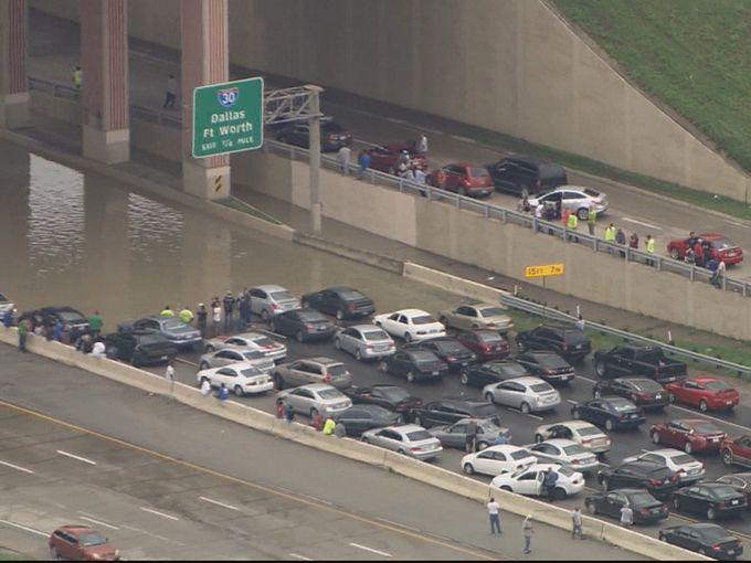
4 Communicating the Message Flash Flood Watch Urban and Small Stream Flood Advisory Flash Flood Warning Flash Flood Emergency Haltom City, TX June 18, 2007 Photo Credit: Fort Worth Star- Telegram 8

5 Flash Flood Watch Current or forecast hydrometeorological conditions are favorable for heavy rain & flash flooding in the watch area Avg size 46,000 km 2 (18,000 mi 2 ) Issued ~ hours in advance of expected heavy rain Example of a Flash Flood Watch Heavy rainfall of 2-4 inches may lead to flash flooding in the green highlighted region tomorrow night 9
 and forecaster")
 HPC graphic 10")
6 Flash Flood Watch - tools Observed or forecast atmospheric moisture profiles Conceptual models (fronts) and forecaster expertise Numerical Model Output National NWS guidance Consideration for existing soil moisture (e.g. FFG) HPC graphic 10
 Issued when radar or rain gauge reports indicate excessive rainfall rates or when dam/levee breaks expected BULLETIN - EAS ACTIVATION REQUESTED FLASH FLOOD WARNING")
7 Flash Flood Warning Widely disseminated text product informs the public, emergency managers, and other agencies that flash flooding is imminent or is occurring. Avg size 3000 km 2 (1200 mi 2 ) Issued when radar or rain gauge reports indicate excessive rainfall rates or when dam/levee breaks expected BULLETIN - EAS ACTIVATION REQUESTED FLASH FLOOD WARNING NATIONAL WEATHER SERVICE FORT WORTH TX 1115 AM CDT TUE MAR THE NATIONAL WEATHER SERVICE IN FORT WORTH HAS ISSUED A * FLASH FLOOD WARNING FOR... DALLAS COUNTY IN NORTH CENTRAL TEXAS EASTERN TARRANT COUNTY IN NORTH CENTRAL TEXAS * UNTIL 215 PM CDT * AT 1115 AM CDT...NATIONAL WEATHER SERVICE METEOROLOGISTS DETECTED THUNDERSTORMS WITH HEAVY RAIN ALONG A LINE EXTENDING FROM GARLAND TO ARLINGTON MOVING NORTHEAST AT 15 MPH. RADAR INDICATES THAT 1 TO 2 INCHES OF RAIN HAS ALREADY FALLEN. ANOTHER 1 TO 2 INCHES WILL BE POSSIBLE THROUGH 215 PM CDT. LAT...LON


8 Flash Flood Warning - Tools Radar reflectivity and rainfall trends Rain gauge reports Report of dam or levee failure Flooding reports Decision assistance tool (FFMP) compares radar rainfall estimates with RFC flash flood guidance Forecaster knowledge of flood prone areas FFMP Estimate of 3-hr rainfall on 18 June Heaviest rain indicated on upstream basins of White s Branch of Big Fossil Creek. 12


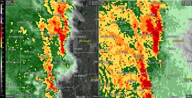
9 Flash Flood Warning - Tools May 29, 2015 ~ 5 AM CDT 13


10 Flash Flood Warning - Tools May 29, 2015 ~ 5 AM CDT Dual-Pol Estimates Legacy Estimates 14


 Example of FFMP output 18")
11 Flash Flood Monitoring and Prediction (FFMP) Tool An integrated suite of applications which analyzes and monitors precipitation Runs on AWIPS workstations Generates short-term warning guidance for Flash Flooding Supplements forecaster event monitoring Conducts precipitation analyses in a basin world : all calculations are performed over the areas of small basins Avg basin size 13 km 2 (5 mi 2 ) Example of FFMP output 18 June


 or add l rain needed")
12 FFMP How It Works Maps FFG to small basins Compares radar estimated rainfall to FFG in each basin Threat tables and maps highlight basins where rainfall > FFG Source: 1-hr, 3-hr, 6-hr FFG from RFC Typical sources: dual-pol QPE, legacy 88D precip estimate, etc Diff column gives amount of runoff (+) or add l rain needed (-) to cause FF

13 Flash Flood Emergency Exceedingly rare issuance Consists of a special headline in a Flash Flood Warning or Statement Must be clear evidence that people have been placed in life-threatening situations by rapidly rising floodwaters Trusted report from EM, broadcast media, law enforcement could prompt FFE issuance Photo Credit: KSPR-TV Springfield MO...THIS IS A FLASH FLOOD EMERGENCY FOR SOUTHERN SPRINGFIELD... AT 1255 PM CDT...LOCAL LAW ENFORCEMENT OFFICIALS REPORTED SLOW MOVING THUNDERSTORMS WITH VERY HEAVY RAINFALL ACROSS THE WARNED AREA. EMERGENCY MANAGEMENT AND LOCAL LAW ENFORCEMENT IS REPORTING HOMES BEING FLOODED ALONG WITH NUMEROUS FLOODED ROADWAYS AND HIGH WATER RESCUES ONGOING IN SOUTHERN GREENE COUTY AND SOUTH SPRINGFIELD. UP TO NINE INCHES OF RAINFALL HAS FALLEN IN THE FLASH FLOOD EMERGENCY AREA AND ADDITIONAL HEAVY RAINFALL IS EXPECTED. 17

14 Flood Warnings Site Specific NWS WFO runs site specific model for fast response creeks and streams Flooding at these sites generally less of a threat to life than Flash Flooding Response times < 6 hrs Site Specific basins across north Texas 18


15 Flood Warnings DWRT2 White Rock Creek flows into White Rock Lake NE of downtown Dallas Forecasters adjust rainfall and QPF to instantly produce first guess hydrograph If expected to exceed Flood Stage, WFO will issue FLW for the event Option to use SAC-SMA or API for model Sample of Site Specific Model run for DWRT2; the basin is shown in the inset image. User adjusts pcpn/qpf in top panel and model output is shown with flood categories in large middle panel. 19


16 Concerns in the Metroplex Potential for catastrophic flash flooding is substantial Mayfest 1995: 17 FF fatalities Hail + Flooding: $2B Rainfall rate: 5 cm/15 min NWS mission:..weather, hydrologic, forecasts and warnings for the protection of life and property NWS radar image of Mayfest Storm Copyright Samuel D. Barricklow 20

17 Flash Flood Warnings from April 13 May 30, FFWs for Dallas/Tarrant/Denton/ Collin 38 NEW and 8 EXT Most were on or after May 24,

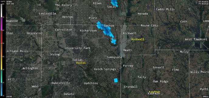
18 Recent Metroplex Flooding Rowlette Creek Sachse White Rock Creek Dallas 22


19 Recent Metroplex Flooding WFAA Fort Worth Star- Telegram WFAA Assoc. Press USA Today Longview News Journal WFAA 23
20 Acknowledgements This presentation was derived from a presentation given by Greg Patrick in Photo Credits, as noted on each slide, include Fort Worth Star-Telegram, WFAA, Associated Press, USA Today, KSPR-TV, and Samuel D. Barricklow 24

21 Questions/Comments?
Severe Weather Watches, Advisories & Warnings
 Severe Weather Watches, Advisories & Warnings Tornado Watch Issued by the Storm Prediction Center when conditions are favorable for the development of severe thunderstorms and tornadoes over a larger-scale
Haiti and Dominican Republic Flash Flood Initial Planning Meeting
 Dr Rochelle Graham Climate Scientist Haiti and Dominican Republic Flash Flood Initial Planning Meeting September 7 th to 9 th, 2016 Hydrologic Research Center http://www.hrcwater.org Haiti and Dominican
We Had No Warning An Overview of Available Forecast Products Before and During Severe Weather Events
 We Had No Warning An Overview of Available Forecast Products Before and During Severe Weather Events Two main sources for severe weather info NOAA/NWS Storm Prediction Center (SPC) Convective Outlooks
Unit 4. This unit will enable you to improve coordination and communication with State and local agencies when hazardous weather threatens.
 Unit 4 This unit will enable you to improve coordination and communication with State and local agencies when hazardous weather threatens. In this unit we will discuss the role of Emergency Managers in
Heavy Rain and Potential for Dangerous Flooding for northeast SC and southeast NC
 US National Weather Service Wilmington NC @NWSWilmingtonNC http://weather.gov/ilm ***Life Threatening Flooding Possible*** Heavy Rain and Potential for Dangerous Flooding for northeast SC and southeast
Charles Kuster Leadville, CO. Personal Overview
 Charles Kuster Leadville, CO Personal Overview Personal Overview Charles Kuster Leadville, CO OU to study meteorology Charles Kuster Leadville, CO Personal Overview OU to study meteorology Graduated in
An Overview of Operations at the West Gulf River Forecast Center Gregory Waller Service Coordination Hydrologist NWS - West Gulf River Forecast Center
 National Weather Service West Gulf River Forecast Center An Overview of Operations at the West Gulf River Forecast Center Gregory Waller Service Coordination Hydrologist NWS - West Gulf River Forecast
GC Briefing. Weather Sentinel Tropical Storm Michael. Status at 8 AM EDT (12 UTC) Today (NHC) Discussion. October 11, 2018
 Today (NHC) Discussion. October 11, 2018") GC Briefing Weather Sentinel Tropical Storm Michael October 11, 2018 After making landfall as a high-end category-4 hurricane on the Florida Panhandle, Michael weakened to tropical storm status early this
GC Briefing Weather Sentinel Tropical Storm Michael October 11, 2018 After making landfall as a high-end category-4 hurricane on the Florida Panhandle, Michael weakened to tropical storm status early this
CASA WX DFW URBAN DEMONSTRATION NETWORK
 CASA WX DFW URBAN DEMONSTRATION NETWORK Goals Background on Regional CASA WX Project Explain the capabilities, structure of the Radar Network Present the CASA WX DFW Test Bed will be rolled out Describe
FLOOD/SCS EVENT, APRIL 28 MAY 4
 REPORT DATE: May 4, 2017 EVENT DATE: April 28-May 4, 2017 FLOOD/SCS EVENT, APRIL 28 MAY 4 Event Summary General Significant Flood Outlook. SOURCE: National Weather Service. A significant severe thunderstorm
The Hydrologic Cycle: How Do River Forecast Centers Measure the Parts?
 The Hydrologic Cycle: How Do River Forecast Centers Measure the Parts? Greg Story Meteorologist National Weather Service Fort Worth, TX Overview n Introduction What is the mission of an RFC? n The Hydrologic
Winter Weather. National Weather Service Buffalo, NY
 Winter Weather National Weather Service Buffalo, NY Average Seasonal Snowfall SNOWFALL = BIG IMPACTS School / government / business closures Airport shutdowns/delays Traffic accidents with injuries/fatalities
Building a Weather-Ready Wisconsin
 National Weather Service Session: Building a Weather-Ready Wisconsin WEMA Conference October 11, 2017 Jeff Last National Weather Service Green Bay Today s Presentation NWSChat in EM Operations The June
Speakers: NWS Buffalo Dan Kelly and Sarah Jamison, NERFC Jeane Wallace. NWS Flood Services for the Black River Basin
 Speakers: NWS Buffalo Dan Kelly and Sarah Jamison, NERFC Jeane Wallace NWS Flood Services for the Black River Basin National Weather Service Who We Are The National Oceanic and Atmospheric Administration
NWS Mission 5/25/2017. Innovations in Flood Forecasting at the National Weather Service West Gulf River Forecast Center
 Innovations in Flood Forecasting at the National Weather Service West Gulf River Forecast Center Kris Lander, PE, CFM Gregory Waller NWS West Gulf River Forecast Center NWS Mission To provide weather,
Significant Flooding Expected
 Significant Flooding Expected Decision Support Briefing #5 As of: 9:00 AM September 14, 2018 What Has Changed? Flash Flood Watch now in effect for part of area, will be expanded later today 9/14/2018 9:23
Unit 5: NWS Hazardous Weather Products. Hazardous Weather and Flooding Preparedness
 Unit 5: NWS Hazardous Weather Products Objectives Describe the mission of the NWS Describe the basic organizational structure of the NWS Explain the purpose of various NWS products Explain how Probability
The Wind Hazard: Messaging the Wind Threat & Corresponding Potential Impacts
 The Wind Hazard: Messaging the Wind Threat & Corresponding Potential Impacts Scott Spratt Warning Coordination Meteorologist NWS Melbourne, FL David Sharp Science & Operations Officer NWS Melbourne, FL
Rainfall-River Forecasting: Overview of NOAA s Role, Responsibilities, and Services
 Dr. Thomas Graziano Chief Hydrologic Services Division NWS Headquarters Steve Buan Service Coordination Hydrologist NWS North Central River Forecast Center Rainfall-River Forecasting: Overview of NOAA
Arkansas-Red Basin River Forecast Center Operations. RRVA Conference Durant, OK 8/22/2013 Jeff McMurphy Sr. Hydrologist - ABRFC
 Arkansas-Red Basin River Forecast Center Operations RRVA Conference Durant, OK 8/22/2013 Jeff McMurphy Sr. Hydrologist - ABRFC NWS River Forecast Centers NWS Weather Forecast Offices Operations Staffing
NWS Resources For Public Works
 NWS Resources For Public Works August 28th, 2016 Shawn DeVinny shawn.devinny@noaa.gov Meteorologist National Weather Service Twin Cities/Chanhassen, MN 1 APWA 2016 PWX 8/28/2016 National Weather Service
IWT Scenario 2 Integrated Warning Team Workshop National Weather Service Albany, NY October 31, 2014
 IWT Scenario 2 Integrated Warning Team Workshop National Weather Service Albany, NY October 31, 2014 09 10 11 12 13 Scenario 2 Timeline December 9-13 Tue Wed Thu Fri Sat Tue, Dec. 9 @ 5 am 2014 2014 2014
TROPICAL STORM HARVEY BRIEFING
 TROPICAL STORM HARVEY BRIEFING 10:00 AM CDT Sunday, August 27, 2017 Prepared by: NWS LIX NWSNewOrleans www.weather.gov/neworleans Situation Overview New Information Tropical Storm Winds 40mph Immediate
Building A Weather-Ready Nation
 Building A Weather-Ready Nation Steve Runnels National Weather Service Springfield, MO` Photo Credit: Tim Marshall 122 National Weather Service Offices NWS Offices Service Missouri and Warning Coordination
Weather can change quickly...are you on top of the changes?
 Weather Access Bob Glancy NOAA National Weather Service, Boulder, CO Near Cedar Point, CO May 9, 2004 Weather can change quickly...are you on top of the changes? National Weather Service Local offices:
TROPICAL STORM HARVEY BRIEFING
 TROPICAL STORM HARVEY BRIEFING 2:00 PM CDT Tuesday, August 29, 2017 Prepared by: NWS LIX NWSNewOrleans www.weather.gov/neworleans Situation Overview New Information Moving NNE Max sustained wind 45 mph
Radar Network for Urban Flood and Severe Weather Monitoring
 Radar Network for Urban Flood and Severe Weather Monitoring V. Chandrasekar 1 and Brenda Philips 2 Colorado State University, United States University of Massachusetts, United States And the full DFW team
Regional Flash Flood Guidance and Early Warning System
 WMO Training for Trainers Workshop on Integrated approach to flash flood and flood risk management 24-28 October 2010 Kathmandu, Nepal Regional Flash Flood Guidance and Early Warning System Dr. W. E. Grabs
Severe Weather Hazards Are Real
 Severe Weather Hazards Are Real In the past 10 years, more than 40 people have died and dozens more injured as a result of weatherrelated events in Minnesota (not including motor vehicles.) The top severe
WEATHER FORECASTING Acquisition of Weather Information WFO Regions Weather Forecasting Tools Weather Forecasting Tools Weather Forecasting Methods
 1 2 3 4 5 6 7 8 WEATHER FORECASTING Chapter 13 Acquisition of Weather Information 10,000 land-based stations, hundreds of ships and buoys; four times a day, airports hourly Upper level: radiosonde, aircraft,
The Integrated Warning Partnership: Opportunities for Improved Community-Level Benefits. Dale Morris Oklahoma Climatological Survey April 18, 2006
 The Integrated Warning Partnership: Opportunities for Improved Community-Level Benefits Dale Morris Oklahoma Climatological Survey April 18, 2006 My Personal Motivation Sunday Evening, September 5, 1992
SPC Mission Statement. Tornado in Miami, FL Photo: Miami Herald. What is SPC s Responsibility? More SPC Products. SPC Products
 The NOAA/NWS Storm Prediction Center Adapted from a presentation to UNCA atmospheric science students by David Imy SPC Mission Statement SPC exists to protect life and property of the American people through
CASA DFW Urban Demonstration Network
 CASA DFW Urban Demonstration Network Cedar League, University of Colorado Colorado Springs Brenda Philips University of Massachusetts Integrated Warning Team Meeting March 6, 2013 Cutting Edge Radars for
SURVIVING THE STORM: A Severe Weather Safety Guide for West Texans
 SURVIVING THE STORM: A Severe Weather Safety Guide for West Texans National Weather Service Weather Forecast Office Midland, Texas www.weather.gov/midland Fundamental Definitions WATCH Conditions are favorable
J4.6 UNDERSTANDING THE MESOSCALE PROCESSES OF FLASH FLOODS: IMPACTS ON PREDICTION AND RESPONSE
 J4.6 UNDERSTANDING THE MESOSCALE PROCESSES OF FLASH FLOODS: IMPACTS ON PREDICTION AND RESPONSE Matthew Kelsch Cooperative Program for Operational Meteorology, Education and Training (COMET ) University
NWS Resources For School Districts
 NWS Resources For School Districts January 23rd, 2017 Shawn DeVinny shawn.devinny@noaa.gov Meteorologist National Weather Service Twin Cities/Chanhassen, MN Outline Watches/Warnings/Advisories Example
Linking the Hydrologic and Atmospheric Communities Through Probabilistic Flash Flood Forecasting
 Linking the Hydrologic and Atmospheric Communities Through Probabilistic Flash Flood Forecasting Wallace Hogsett Science and Operations Officer NOAA/NWS/Weather Prediction Center with numerous contributions
Heavy Rainfall Event of June 2013
 Heavy Rainfall Event of 10-11 June 2013 By Richard H. Grumm National Weather Service State College, PA 1. Overview A 500 hpa short-wave moved over the eastern United States (Fig. 1) brought a surge of
United States Multi-Hazard Early Warning System
 United States Multi-Hazard Early Warning System Saving Lives Through Partnership Lynn Maximuk National Weather Service Director, Central Region Kansas City, Missouri America s s Weather Enterprise: Protecting
Mark Fox Meteorologist NWS Fort Worth, TX
 Mark Fox Meteorologist NWS Fort Worth, TX Mark Fox Meteorologist NWS Fort Worth, TX What does severe really mean? Heavy Rain? Hail? Flooding? Wind? Lightning? What does severe really mean? Photo: Mike
THE IMPACT OF WEATHER
 The United States is the most severe weather prone country in the world. Each year, people in this country cope with an average of 10,000 thunderstorms, 5,000 floods, 1,200 tornadoes and two landfalling
Mid-West Heavy rains 18 April 2013
 Abstract: Mid-West Heavy rains 18 April 2013 By Richard H. Grumm and Charles Ross National Weather Service State College, PA The relatively wet conditions during the first 16 days of April 2013 set the
TROPICAL STORM HARVEY BRIEFING
 TROPICAL STORM HARVEY BRIEFING 8:00 AM CDT Monday, August 28, 2017 Prepared by: Brian Hoeth, Jason Johnson, on behalf of WGRFC www.weather.gov Current Storm Total Rainfall and River Flood Status 24 Storm
Flash Flood Guidance System On-going Enhancements
 Flash Flood Guidance System On-going Enhancements Hydrologic Research Center, USA Technical Developer SAOFFG Steering Committee Meeting 1 10-12 July 2017 Jakarta, INDONESIA Theresa M. Modrick Hansen, PhD
National Weather Service Greenville-Spartanburg, Forecast Office
 National Weather Service Greenville-Spartanburg, Forecast Office CoCoRaHS Presentation: NC CERT Conference May, 2017 Introduction- who we are. Federal Agency Within the U.S. Dept. of Commerce Introduction-
The NOAA/NWS Warning Decision Training Branch (WDTB): On-line Training Resources for Emergency Managers & Intro to Dual-Polarization Radar
: On-line Training Resources for Emergency Managers & Intro to Dual-Polarization Radar") The NOAA/NWS Warning Decision Training Branch (WDTB): On-line Training Resources for Emergency Managers & Intro to Dual-Polarization Radar Andy Wood CIMMS (University of Oklahoma)/ WDTB (NOAA/NWS) The
The NOAA/NWS Warning Decision Training Branch (WDTB): On-line Training Resources for Emergency Managers & Intro to Dual-Polarization Radar Andy Wood CIMMS (University of Oklahoma)/ WDTB (NOAA/NWS) The
TROPICAL STORM HARVEY COE Navigation Call - Update
 TROPICAL STORM HARVEY COE Navigation Call - Update 10:00 AM CDT Tuesday, August 29, 2017 Prepared by: NWS LIX NWSNewOrleans www.weather.gov/neworleans Situation Overview New Information Drifting ENE at
Frank Revitte National Weather Service. Weather Forecast Office New Orleans/Baton Rouge
 Frank Revitte National Weather Service Weather Forecast Office New Orleans/Baton Rouge Above normal activity 17 Total Named Storms 7 Tropical Storms 4 Hurricanes 6 Major Hurricanes Not the most active,
Tropical Update. 5 PM EDT Sunday, September 10, 2017 Hurricane Irma, Hurricane Jose, Tropical Wave (60%)
") Tropical Update 5 PM EDT Sunday, September 10, 2017 Hurricane Irma, Hurricane Jose, Tropical Wave (60%) This update is intended for government and emergency response officials, and is provided for informational
Tropical Update 5 PM EDT Sunday, September 10, 2017 Hurricane Irma, Hurricane Jose, Tropical Wave (60%) This update is intended for government and emergency response officials, and is provided for informational
Areal Reduction Factors for the Colorado Front Range and Analysis of the September 2013 Colorado Storm
 Areal Reduction Factors for the Colorado Front Range and Analysis of the September 2013 Colorado Storm Doug Hultstrand, Bill Kappel, Geoff Muhlestein Applied Weather Associates, LLC - Monument, Colorado
At the start of the talk will be a trivia question. Be prepared to write your answer.
 Operational hydrometeorological forecasting activities of the Australian Bureau of Meteorology Thomas Pagano At the start of the talk will be a trivia question. Be prepared to write your answer. http://scottbridle.com/
Delaware River Flood Advisory Committee
 Delaware River Flood Advisory Committee A Partnership to Support Flood Mitigation Alan Tamm Pennsylvania Emergency Management Agency Bureau of Recovery and Mitigation atamm@state.pa.us Peter Gabrielsen
2017 Hurricane Season and Beyond
 2017 Hurricane Season and Beyond Ken Graham National Hurricane Center Building a Weather-Ready Nation Much of U.S. Coast Saw Tropical Wind Watches or Warnings 2017 Hurricane Season Facts and Figures 7th
Monday, October 19, CDT Brian Hoeth
 Monday, October 19, 2015 1400 CDT Brian Hoeth Some of the briefing presented is worstcase scenario and may differ in detail from local NWS Weather Forecast Offices. National Weather Service Southern Region
Existing NWS Flash Flood Guidance
 Introduction The Flash Flood Potential Index (FFPI) incorporates physiographic characteristics of an individual drainage basin to determine its hydrologic response. In flash flood situations, the hydrologic
Operational Hydrologic Ensemble Forecasting. Rob Hartman Hydrologist in Charge NWS / California-Nevada River Forecast Center
 Operational Hydrologic Ensemble Forecasting Rob Hartman Hydrologist in Charge NWS / California-Nevada River Forecast Center Mission of NWS Hydrologic Services Program Provide river and flood forecasts
SEVERE WEATHER 101. Flood Basics
 SEVERE WEATHER 101 Flood Basics What is flooding? Flooding is an overflowing of water onto land that is normally dry. Floods can happen during heavy rains, when ocean waves come on shore, when snow melts
TROPICAL CYCLONE TORNADOES
 TROPICAL CYCLONE TORNADOES 2018 GOVERNOR S HURRICANE CONFERENCE TUESDAY, MAY 15, 2018 WILL ULRICH NWS FORECAST OFFICE MELBOURNE WHERE ARE THE TORNADOES? WHERE ARE THE TORNADOES? C B A WEST MELBOURNE, FL
Hurricane Matthew Life Threatening Flash Flooding Likely
 Hurricane Matthew Life Threatening Flash Flooding Likely Threat Assessment for northeast South Carolina & southeast North Carolina National Weather Service Wilmington NC 12 AM EDT Saturday October 8, 2016
The illusion of Storm Based Warnings. Daryl Herzmann Iowa State University
 The illusion of Storm Based Warnings Daryl Herzmann Iowa State University Don t agree with something you see? Do what this guy did! I ll act indignant and ignore you. Why am I so bitter? 1. Old Age 2.
Geoprocessing Hydrometeorological Datasets to Assess National Weather Service (NWS) Forecasts
 Forecasts") Geoprocessing Hydrometeorological Datasets to Assess National Weather Service (NWS) Forecasts Jack Settelmaier National Weather Service Southern Region HQ Fort Worth, Texas ABSTRACT The National Weather
Geoprocessing Hydrometeorological Datasets to Assess National Weather Service (NWS) Forecasts Jack Settelmaier National Weather Service Southern Region HQ Fort Worth, Texas ABSTRACT The National Weather
Operational Perspectives on Hydrologic Model Data Assimilation
 Operational Perspectives on Hydrologic Model Data Assimilation Rob Hartman Hydrologist in Charge NOAA / National Weather Service California-Nevada River Forecast Center Sacramento, CA USA Outline Operational
CHAPTER 13 WEATHER ANALYSIS AND FORECASTING MULTIPLE CHOICE QUESTIONS
 CHAPTER 13 WEATHER ANALYSIS AND FORECASTING MULTIPLE CHOICE QUESTIONS 1. The atmosphere is a continuous fluid that envelops the globe, so that weather observation, analysis, and forecasting require international
Michael L. Jurewicz, Sr. NOAA/NWS, Binghamton, NY WFO GYX Spring Workshop May 7, 2012
 Michael L. Jurewicz, Sr. NOAA/NWS, Binghamton, NY WFO GYX Spring Workshop May 7, 2012 Motivation / Statistics Specific Topics A Sampling of Past and Present WFO BGM Research on Flooding Three Strikes and
DEPARTMENT OF EARTH & CLIMATE SCIENCES SAN FRANCISCO STATE UNIVERSITY. Metr Fall 2014 Test #1 September 30, 2014
 DEPARTMENT OF EARTH & CLIMATE SCIENCES SAN FRANCISCO STATE UNIVERSITY NAME Metr 302.02 Fall 2014 Test #1 September 30, 2014 200 pts (4 pts each answer) Part I. Surface Chart Interpretation. Questions 1
Hurricane Harvey: SE Texas Impacts. 10 PM CDT UPDATE Friday, August 25, 2017 Prepared by: Lance Wood
 Hurricane Harvey: SE Texas Impacts 10 PM CDT UPDATE Friday, August 25, 2017 Prepared by: Lance Wood Latest Observations Hurricane Harvey making landfall this evening near Rockport as a category 4 hurricane.
Friday, September 7, :30 a.m. EDT
 Friday, September 7, 2018 8:30 a.m. EDT Tropical Depression Gordon - Final Situation (Advisory #20 as of 5:00 a.m. EDT) Located 30 miles S of Little Rock, AR Moving N at 5 mph; this motion expected to
SPEARFISH FIRE DEPARTMENT POLICIES AND PROCEDURES
 SPEARFISH FIRE DEPARTMENT POLICIES AND PROCEDURES Page 1 of 5 Volume: Operation Section: 20.00 Number: 20.09 Subject: Weather Watches, Warnings, Advisory s and Spotter Activation Date Issued: 28 March
10 years after Hurricane Charley
 10 years after Hurricane Charley Hurricane Charley (2004) A Retrospective Scott M. Spratt Warning Coordination Meteorologist NWS Melbourne, FL Florida Governors Hurricane Conference May 15, 2014 11 AM
A LOOK AT TROPICAL STORM GASTON FLOODING IN VIRGINIA
 J12B.4 A LOOK AT TROPICAL STORM GASTON FLOODING IN VIRGINIA John Billet* and Keith Lynch NOAA/NWS Wakefield, VA 1. INTRODUCTION Hurricane Gaston made landfall north of Charleston, SC on Sunday morning
Robert Shedd Northeast River Forecast Center National Weather Service Taunton, Massachusetts, USA
 Robert Shedd Northeast River Forecast Center National Weather Service Taunton, Massachusetts, USA Outline River Forecast Centers FEWS Implementation Status Forcing Data Ensemble Forecasting The Northeast
GC Briefing. Weather Sentinel Hurricane Florence. Status at 5 PM EDT (21 UTC) Today (NHC) Discussion. September 13, 2018
 Today (NHC) Discussion. September 13, 2018") GC Briefing September 13, 2018 Weather Sentinel Hurricane Florence Tropical storm conditions have been reported for areas of North Carolina and will continue to spread inland to the west and south. Hurricane
GC Briefing September 13, 2018 Weather Sentinel Hurricane Florence Tropical storm conditions have been reported for areas of North Carolina and will continue to spread inland to the west and south. Hurricane
Areal Reduction Factors for the Colorado Front Range and Analysis of the September 2013 Colorado Storm
 Areal Reduction Factors for the Colorado Front Range and Analysis of the September 2013 Colorado Storm Doug Hultstrand, Bill Kappel, Geoff Muhlestein Applied Weather Associates, LLC - Monument, Colorado
Tropical Update. 5 AM EDT Tuesday, September 12, 2017 Post-Tropical Cyclone Irma, Hurricane Jose, & Tropical Wave (10%)
") Tropical Update 5 AM EDT Tuesday, September 12, 2017 Post-Tropical Cyclone Irma, Hurricane Jose, & Tropical Wave (10%) This update is intended for government and emergency response officials, and is provided
Tropical Update 5 AM EDT Tuesday, September 12, 2017 Post-Tropical Cyclone Irma, Hurricane Jose, & Tropical Wave (10%) This update is intended for government and emergency response officials, and is provided
Flood Forecasting Methods and Models Calgary, Alberta February 19, 2014
 Flood Forecasting Methods and Models Calgary, Alberta February 19, 2014 Why Am I Here? Why Am I Here? It s Winter Olympics time! Colorado is the home of such athletes as Lindsey Vonn, Todd Lodwick, Mikaela
 Hazard Warnings GE 4150 Natural Hazards September 17, 2007 http://www.sdr.gov/ndis_rev_oct27.pdf Sorensen, J.H. (2000) Hazard warning systems: Review of 20 years of progress. Natural Hazards Review, May,
Flood warnings were issued for the Maumee, St. Marys, Blanchard, St. Joseph (Ohio), Tippecanoe, Tiffin, Eel and Wabash Rivers on the 30 th and 31 st.
, Tippecanoe, Tiffin, Eel and Wabash Rivers on the 30 th and 31 st.") NWS FORM E-5 U.S. DEPARTMENT OF COMMERCE HSA OFFICE: NOAA, NATIONAL WEATHER SERVICE MONTHLY REPORT OF RIVER AND FLOOD CONDITIONS DATE: TO: North Webster, IN REPORT FOR (MONTH &YEAR): January 2002 February
NWS FORM E-5 U.S. DEPARTMENT OF COMMERCE HSA OFFICE: NOAA, NATIONAL WEATHER SERVICE MONTHLY REPORT OF RIVER AND FLOOD CONDITIONS DATE: TO: North Webster, IN REPORT FOR (MONTH &YEAR): January 2002 February
Tropical Storm Colin Briefing Last Briefing on this System
 Tropical Storm Colin Briefing Last Briefing on this System NWS WFO Jacksonville, Florida Tuesday, June 07, 2016 6:00 a.m. EDT Tropical Storm Colin s Impacts SE Georgia & North Florida Local Watches & Warnings:
NWS SERFC Hydrologic Vulnerability Assessment. Monday, March 9 th, 2015 NOAA, National Weather Service Southeast River Forecast Center
 NWS SERFC Hydrologic Vulnerability Assessment Monday, March 9 th, 2015 NOAA, National Weather Service Southeast River Forecast Center Current Weather Map Today s weather map shows a blossoming system in
IWT Scenario 1 Integrated Warning Team Workshop National Weather Service Albany, NY October 31, 2014
 Integrated Warning Team Workshop National Weather Service Albany, NY October 31, 2014 23 24 25 26 27 Scenario 1 Timeline November 23-27 Sun Mon Tue Wed Thu Thanksgiving Day Sunday, Nov. 23 @ 430 pm NWS
A Prepared Marylander Creates a Resilient Maryland
 Maryland Emergency Management Agency Operations Directorate Hazardous Winter Weather Outlook Briefing March 5, 2013 0800 A Prepared Marylander Creates a Resilient Maryland A strong low pressure will track
Tropical Weather Briefing
 Tropical Weather Briefing August 28, 2012 700 AM CDT National Weather Service Weather Forecast Office Slidell, LA Current Satellite Tropical Storm Isaac Watches/Warnings Tropical Storm Isaac Track Guidance
Issued by: National Weather Service San Joaquin Valley - Hanford CA. Issue time: 409 AM PST Wed Jan
 Forecast Information Location: New_Exchequer_Dam Updated: January 16, 2019, 11:45 am NWS Weather Discussion: Issued by: National Weather Service San Joaquin Valley - Hanford CA Issue time: 409 AM PST Wed
David R. Vallee Hydrologist-in-Charge NOAA/NWS Northeast River Forecast Center
 David R. Vallee Hydrologist-in-Charge NOAA/NWS Northeast River Forecast Center Record flooding along the Shawsheen River during the 2006 Mother s Day Floods Calibrate and implement a variety of hydrologic
Kentucky Weather Hazards: What is Your Risk?
 Kentucky Weather Hazards: What is Your Risk? Stuart A. Foster State Climatologist for Kentucky 2010 Kentucky Weather Conference Bowling Green, Kentucky January 16, 2010 Perspectives on Kentucky s Climate
Eastern Shore Weather and Climate. Bill Sammler Warning Coordination Meteorologist National Weather Service Wakefield, VA
 Eastern Shore Weather and Climate Bill Sammler Warning Coordination Meteorologist National Weather Service Wakefield, VA About The NWS The National Weather Service is: A Federal Government Agency Part
USA National Weather Service Community Hydrologic Prediction System
 USA National Weather Service Community Hydrologic Prediction System Rob Hartman Hydrologist in Charge NOAA / National Weather Service California-Nevada River Forecast Center Sacramento, CA Background Outline
J1.2 LOCALLY MODIFYING FLASH FLOOD GUIDANCE TO IMPROVE THE DETECTION CAPABILITY OF THE FLASH FLOOD MONITORING AND PREDICTION PROGRAM
 J1.2 LOCALLY MODIFYING FLASH FLOOD GUIDANCE TO IMPROVE THE DETECTION CAPABILITY OF THE FLASH FLOOD MONITORING AND PREDICTION PROGRAM Robert S. Davis* NOAA/National Weather Service, Pittsburgh, PA 1. INTRODUCTION
RSMC-Miami Update Daniel Brown Warning Coordination Meteorologist
 RSMC-Miami Update 2016 Daniel Brown Warning Coordination Meteorologist L-0324 Emergency Management Hurricane Preparedness Training Course Funding provided by FEMA s National Hurricane Program - partnership
National Weather Service
 National Weather Service Integrated Warning Team Workshops: NWS Warnings and Outdoor Warning Sirens Tim Halbach Warning Coordination Meteorologist Milwaukee NWS Integrated Warning Team NWS State Officials
Linked Environments for Atmospheric Discovery: Web Services for Meteorological Research and Education
 Linked Environments for Atmospheric Discovery: Web Services for Meteorological Research and Education What Would YOU Do if These Were About to Occur? What THEY Do to Us!!! Each year in the US, mesoscale
California OES Weather Threat Briefing
 California OES Weather Threat Briefing Wednesday, January 16, 2019 9:00 AM PST Day 1: Strong winds, heavy mountain snow and heavy rain with isolated thunderstorms across much of the state through Thursday
Nor easter Monday Night Wednesday December 8 10, 2014
 Nor easter Monday Night Wednesday December 8 10, 2014 Prepared 400 PM EST Monday, December 8, 2014 Mitchell Gaines NOAA s Philadelphia/Mount Holly NJ Forecast Office www.weather.gov/phi/ Purpose of Briefing
Daily Operations Briefing Wednesday, July 6, :30 a.m. EDT
 Daily Operations Briefing Wednesday, July 6, 2016 8:30 a.m. EDT Significant Activity: July 5-6 Significant Events: Severe Weather Plains to Ohio Valley Tropical Activity: Atlantic Tropical cyclone activity
Hurricane Matthew. Life Threatening Flash Flooding Likely. National Weather Service Wilmington NC. Josh Weiss, Meteorologist
 Hurricane Matthew Life Threatening Flash Flooding Likely Threat Assessment for northeast South Carolina & southeast North Carolina National Weather Service Wilmington NC 630 PM EDT Friday October 7, 2016
National Situation Report As of 5:00 a.m. EDT Tuesday, April 4, 2017
 Overview National Situation Report As of 5:00 a.m. EDT Tuesday, April 4, 2017 Table Of Contents Current Operations Monitoring Recovery National Response Coordination Center: Not Activated National Watch
High Resolution Numerical Weather Prediction for High Impact and Extreme Weather Events in 2014 across Southern California
 High Resolution Numerical Weather Prediction for High Impact and Extreme Weather Events in 2014 across Southern California Alex Tardy Alexander.Tardy@noaa.gov NWS San Diego Warning Coordination Meteorologist
Goals of Presentation
 Hydrometeorlogical Prediction Center (HPC) Forecast Operations Branch Winter Weather Desk Dan Petersen Dan.Petersen@noaa.gov 301-763-8201 Review HPC winter weather desk forecasts Review winter weather
Coordinated Safety Messaging: An Integrated Approach. Matt Moreland FLGHC: Effective Messaging and Decision Support Services May 16, 2017
 Coordinated Safety Messaging: An Integrated Approach Matt Moreland FLGHC: Effective Messaging and Decision Support Services May 16, 2017 Question According to most meteorologists, how long should a weather