Merced Irrigation District Hydrologic and Hydraulic Operations (MIDH2O) Model
|
|
|
- Kristina Sherman
- 5 years ago
- Views:
Transcription

")


1 Merced Irrigation District Hydrologic and Hydraulic Operations (MIDH2O) Model September 05, 2018 Marco Bell, Merced Irrigation District Bibek Joshi, Dewberry
2 Objective Introduce HEC-RTS Benefits of MIDH2O 2 MIDH2O September 05, 2018
3 MIDH2O Origins 2015 USBR WaterSMART Drought Resiliency Project Grant MIDH2O is the Merced Irrigation District Hydrologic and Hydraulic Operations Model MIDH2O is a tool to assist MID in the management of the Merced River flows, operation of New Exchequer Dam and regulate MID irrigation diversions. MIDH2O can serve as a decision support tool for power generation and help link water and power operations to the hydro power market. Based on HEC-RTS 3 MIDH2O September 05, 2018
4 Merced Irrigation District Established in 1919 * Store and distribute water for irrigation Total irrigable lands in MID: 138,000 acres 825 miles of water distribution facilities (earth lined, concrete lined channels and pipes) Also provides water for domestic uses, provide flood control, hydroelectric power generation, and recreation Provides water to approximately 2,200 farmers in Merced County and affordable electricity to 7,500 residences and business Owns and operates New Exchequer and McSwain Dams, reservoirs and hydroelectric facilities * of the district/ 4 MIDH2O September 05, 2018


5 Merced Irrigation District 5 MIDH2O September 05, 2018
")

6 Merced River Watershed Tributary of San Joaquin River Drainage Area: 1,267 square miles (1,037 square miles at New Exchequer Dam) Elevation Range: 52 13,090 ft (535 square miles above 5,000 feet) Upper watershed in Yosemite National Park 6 MIDH2O September 05, 2018


7 HEC-RTS Publicly available software from HEC Software system supporting data acquisition, visualization, and shortterm forecast modeling Interface to receive and process realtime and forecast meteorological data Link multiple models in a sequence for real-time simulation of hydrology, reservoir operation, river hydraulics, and flood impact analysis 7 MIDH2O September 05, 2018
8 HEC-RTS Supports standard HEC models and can be extended to support other models and data processing tasks Provides access to native model interfaces for data editing and display Deployed to over 35 USACE district and division offices * UASCE version: Corps Water Management System (CWMS) CWMS is server based and uses Oracle Database. HEC-RTS is PC based and uses HEC-DSS. Supplemental Program Meteorological Data MFP HMS ResSim RAS Flow Flow * Custom Report Generator 8 MIDH2O September 05, 2018
9 Why HEC-RTS? Familiarity with HEC models Has an interface to receive and process real-time and forecast meteorological data Discrete models developed outside and then linked together in RTS Provides a platform to integrate different models Rainfall-runoff model to predict peak discharge (HEC- HMS) Reservoir operation model to evaluate reservoir releases (HEC-ResSim) Riverine hydraulics model to predict river stages (HEC- RAS) 9 MIDH2O September 05, 2018

10 HEC-RTS GUI 10 MIDH2O September 05, 2018


11 Data Acquisition and Data Visualization Modules Source: Chan Modini, USACE HEC, Real Time Flow/Stage Forecasting, Inundation Mapping and Decision Support For the Russian River Basin with CWMS 3.0 / HEC RTS 3.0, MIDH2O Symposium, September MIDH2O September 05, 2018


12 Data Acquisition and Data Visualization Modules Source: Chan Modini, USACE HEC, Real Time Flow/Stage Forecasting, Inundation Mapping and Decision Support For the Russian River Basin with CWMS 3.0 / HEC RTS 3.0, MIDH2O Symposium, September MIDH2O September 05, 2018


13 HEC-RTS GUI 13 MIDH2O September 05, 2018

14 14 MIDH2O September 05, 2018
15 Project Overview To provide a Real Time Decision Support System for the Merced Irrigation District Water budget Snow Accumulation, Snow Melt, Rainfall Runoff into Lake McClure Irrigation Deliveries to the Turnouts Flood Forecasting for the Merced Streams Group Power Generation Scheduling 15 MIDH2O September 05, 2018
16 MIDH2O Features Fully automated MIDH2O system Data retrieval and QAQC Generate Forecast Post Results Generate custom report Each forecast run has a three week simulation period two weeks of lookback and 1 week of forecast Forecast simulation run at 6 o clock and 12 o clock PST HEC-HMS includes snowmelt modeling Integrated with MID s WISKI database Scripts written to update initial soil moisture deficit values and transfer initial snowmelt grids 16 MIDH2O September 05, 2018
17 Meteorological Model Uncoupled Surface Layer (USL) model runs a NWP model that focuses entirely on near surface conditions Terrain elevation ranges from 52 to 13,090 ft Orographic effect, mountain shadow, temperature in north vs south facing slopes High resolution (500 meter) hourly gridded precipitation and temperature grids Accurate land surface properties and realistic near surface physics GFS NAM HRRR NDFD SREF Gridded MOS GDPS HIRESW (WRF) Observations Land surface data Tuning params Downscaling & Bias Correction Pre-processor Weighted Ensemble USL Hi-res Terrain data Clouds Precipitation etc. Temperature Humidity Wind (0-100m AGL) Source: CustomWeather Forecasting Merced Irrigation District: The High Resolution Uncoupled Surface Layer (USL) Model, MIDH2O Symposium, September MIDH2O September 05, 2018
18 Precipitation Runoff Model Computes streamflow throughout the Merced River watershed based on observed and forecast precipitation and temperature and watershed runoff characteristics Includes snowmelt computations Event-oriented model run continuously 18 MIDH2O September 05, 2018

19 HEC-HMS Components Loss -> Deficit and Constant Canopy -> Simple Canopy Evapotranspiration -> Monthly Average Moisture deficit can recover Transform -> ModClark Routing -> Modified Puls and Muskingum-Cunge Baseflow -> Recession 19 MIDH2O September 05, 2018
20 Uncertainty in Real-Time Forecasting Inaccuracy in forecast precipitation and temperature Is precipitation falling as rain or snow? HEC-HMS uses one PX Temperature Initial conditions Soil moisture SWE Need professional judgment 20 MIDH2O September 05, 2018
21 MIDH2O January 9, 2017 Event Forecast 30,000 MIDH2O Forecast: Merced River at Pohono Bridge January 9, 2017 Storm OBSERVED 25,000 20,000 Flow (cfs) 15,000 10,000 5, Jan 17, 10:00 04 Jan 17, 10:00 05 Jan 17, 10:00 06 Jan 17, 10:00 07 Jan 17, 10:00 08 Jan 17, 10:00 09 Jan 17, 10:00 10 Jan 17, 10:00 21 MIDH2O September 05, 2018
22 22 MIDH2O September 05, 2018

23 HEC-ResSim Overview To model operations at reservoirs using different set of operational rules and constraints Uses reservoir inflow and downstream local flows computed by HEC-HMS Reservoir operation for Lake McClure, Lake McSwain, and Merced Falls Forebay to water delivery and power generation Determine releases using operation sets and prescribed release schedules Use mass-balance to determine pool elevation and storage for reservoirs 23 MIDH2O September 05, 2018

24 HEC-RAS for MID Unsteady-state hydraulic model of Merced River from the Exchequer Dam to San Joaquin River New model development between Exchequer Dam and Cressey Existing DWR s model of Merced River between Cressey and San Joaquin River Uses reservoir releases from HEC-ResSim and local inflows from HEC-HMS Calibrate to available high water marks and gage record Water quality modeling Sediment transport modeling 24 MIDH2O September 05, 2018
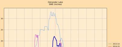
 Merced Watershed Report Historical SWE time series for Ostrander and Tenaya Lakes Lake")
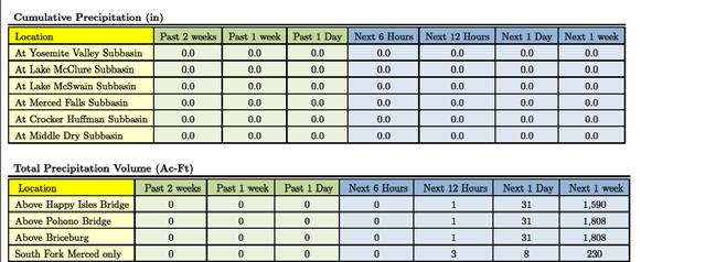
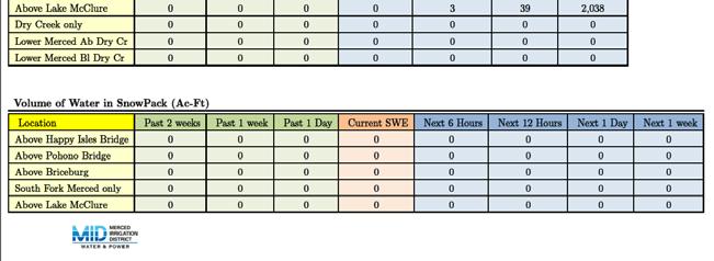
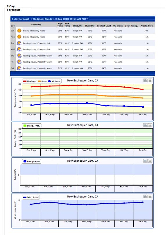
25 Custom Report 29 page report Past, current, and estimated future conditions Precipitation and snowpack Reservoir status Diversion demand Forecasted flow at key downstream locations Appendix includes: Current NWS San Joaquin Valley Report 5-station precipitation index, California snow water content (from CA DWR) Merced Watershed Report Historical SWE time series for Ostrander and Tenaya Lakes Lake McClure current conditions and precipitation 25 MIDH2O September 05, 2018


26 26 MIDH2O September 05, 2018
27 Real-time and Planning Models Real-time Flood and Conditional Space Operations Downstream Flow Requirements Demand and Power Management Hourly Time Forecast for One Week Planning Snow Water Equivalent Analyses April to July Snowmelt Flow Volume Forecast Habitat Restoration Fish Pulse Flows 27 MIDH2O September 05, 2018

28 28 MIDH2O September 05, 2018
29 Additional MIDH2O Benefits HEC HMS Climate Change Impact Analysis Surface water Ground water coupled model HEC ResSim Power Generation and Scheduling HEC RAS October Pulse Flows Update gage rating table Merced River Water quality and temperature modeling 29 MIDH2O September 05, 2018
30 Conclusion Phase 1 went live on October 2016 From day 1, significant benefits realized over legacy forecast methods Improved lead time and flexibility in forecasts and operational alternatives Residual benefits to other district operations through optimization, increased efficiency and increased collaboration 30 MIDH2O September 05, 2018
31 Merced Irrigation District Hydrologic and Hydraulic Operations (MIDH2O) Model Marco Bell Merced Irrigation District Ted Cassidy Dewberry Bibek Joshi Dewberry
CWMS Modeling for Real-Time Water Management
 Hydrologic Engineering Center Training Course on CWMS Modeling for Real-Time Water Management August 2018 Davis, California The Corps Water Management System (CWMS) is a software and hardware system to
INTRODUCTION TO HEC-HMS
 INTRODUCTION TO HEC-HMS Hydrologic Engineering Center- Hydrologic Modeling System US Army Corps of Engineers Hydrologic Engineering Center HEC-HMS Uses Schematics Enter properties: watershed, rivers (reaches),
TRWD Upper Trinity River Flood Operations Decision Support System
 TRWD Upper Trinity River Flood Operations Decision Support System TFMA 2012 Fall Conference Rockwall, Texas September 20, 2012 Presented by: Andrew Ickert, PE, CFM & Craig Ottman, PE, CFM (Halff Associates,
Real-Time Meteorological Gridded Data: What s New With HEC-RAS
 Real-Time Meteorological Gridded Data: What s New With HEC-RAS Acquisition and Application of Gridded Meteorological Data in Support of the USACE s Real-Time Water Management Mission Fauwaz Hanbali, Tom
Operational Hydrologic Ensemble Forecasting. Rob Hartman Hydrologist in Charge NWS / California-Nevada River Forecast Center
 Operational Hydrologic Ensemble Forecasting Rob Hartman Hydrologist in Charge NWS / California-Nevada River Forecast Center Mission of NWS Hydrologic Services Program Provide river and flood forecasts
Real-Time Flood Forecasting Modeling in Nashville, TN utilizing HEC-RTS
 Real-Time Flood Forecasting Modeling in Nashville, TN utilizing HEC-RTS Brantley Thames, P.E. Hydraulic Engineer, Water Resources Section Nashville District, USACE August 24, 2017 US Army Corps of Engineers
NRC Workshop Probabilistic Flood Hazard Assessment (PFHA) Jan 29-31, Mel Schaefer Ph.D. P.E. MGS Engineering Consultants, Inc.
 Jan 29-31, Mel Schaefer Ph.D. P.E. MGS Engineering Consultants, Inc.") Stochastic Event Flood Model (SEFM) Stochastic Modeling of Extreme Floods A Hydrological Tool for Analysis of Extreme Floods Mel Schaefer Ph.D. P.E. MGS Engineering Consultants, Inc. Olympia, WA NRC Workshop
Stochastic Event Flood Model (SEFM) Stochastic Modeling of Extreme Floods A Hydrological Tool for Analysis of Extreme Floods Mel Schaefer Ph.D. P.E. MGS Engineering Consultants, Inc. Olympia, WA NRC Workshop
Flood Forecasting Tools for Ungauged Streams in Alberta: Status and Lessons from the Flood of 2013
 Flood Forecasting Tools for Ungauged Streams in Alberta: Status and Lessons from the Flood of 2013 John Pomeroy, Xing Fang, Kevin Shook, Tom Brown Centre for Hydrology, University of Saskatchewan, Saskatoon
Lake Tahoe Watershed Model. Lessons Learned through the Model Development Process
 Lake Tahoe Watershed Model Lessons Learned through the Model Development Process Presentation Outline Discussion of Project Objectives Model Configuration/Special Considerations Data and Research Integration
Study 16.5 Probable Maximum Flood (PMF)
") Initial Study Report Meeting Study 16.5 Probable Maximum Flood (PMF) October 22, 2014 Prepared by 10/22/2014 1 Study 16.5 Objectives Develop a site-specific PMP to be used for the derivation of the PMF
Initial Study Report Meeting Study 16.5 Probable Maximum Flood (PMF) October 22, 2014 Prepared by 10/22/2014 1 Study 16.5 Objectives Develop a site-specific PMP to be used for the derivation of the PMF
Study 16.5 Probable Maximum Flood (PMF)
") Initial Study Report Meeting Study 16.5 Probable Maximum Flood (PMF) March 30, 2016 Prepared by 3/30/2016 1 Study 16.5 Status ISR documents (ISR Part D Overview): Status: Initial Study Report: Parts A,
Initial Study Report Meeting Study 16.5 Probable Maximum Flood (PMF) March 30, 2016 Prepared by 3/30/2016 1 Study 16.5 Status ISR documents (ISR Part D Overview): Status: Initial Study Report: Parts A,
Pompton Lakes Dam Downstream Effects of the Floodgate Facility. Joseph Ruggeri Brian Cahill Michael Mak Andy Bonner
 Pompton Lakes Dam Downstream Effects of the Joseph Ruggeri Brian Cahill Michael Mak Andy Bonner ASFPM 2013: Overview Page 2 Overview Page 3 Overview Page 4 Overview Page 5 Overview - Historical Pompton
9. PROBABLE MAXIMUM PRECIPITATION AND PROBABLE MAXIMUM FLOOD
 9. PROBABLE MAXIMUM PRECIPITATION AND PROBABLE MAXIMUM FLOOD 9.1. Introduction Due to the size of Watana Dam and the economic importance of the Project to the Railbelt, the Probable Maximum Flood (PMF)
StreamStats: Delivering Streamflow Information to the Public. By Kernell Ries
 StreamStats: Delivering Streamflow Information to the Public By Kernell Ries U.S. Department of the Interior U.S. Geological Survey MD-DE-DC District 410-238-4317 kries@usgs.gov StreamStats Web Application
Robert Shedd Northeast River Forecast Center National Weather Service Taunton, Massachusetts, USA
 Robert Shedd Northeast River Forecast Center National Weather Service Taunton, Massachusetts, USA Outline River Forecast Centers FEWS Implementation Status Forcing Data Ensemble Forecasting The Northeast
Missouri River Flood Task Force River Management Working Group Improving Accuracy of Runoff Forecasts
 Missouri River Flood Task Force River Management Working Group Improving Accuracy of Runoff Forecasts Kevin Grode, P.E. Reservoir Regulation Team Lead Missouri River Basin Water Management Northwestern
Modeling of peak inflow dates for a snowmelt dominated basin Evan Heisman. CVEN 6833: Advanced Data Analysis Fall 2012 Prof. Balaji Rajagopalan
 Modeling of peak inflow dates for a snowmelt dominated basin Evan Heisman CVEN 6833: Advanced Data Analysis Fall 2012 Prof. Balaji Rajagopalan The Dworshak reservoir, a project operated by the Army Corps
Development of the Hydrologic Model
 Kick-off meeting on enhancing hydrological data management and exchange procedures Water and Climate Adaptation Plan (WATCAP) for Sava River Basin Development of the Hydrologic Model David Heywood Team
FORECAST-BASED OPERATIONS AT FOLSOM DAM AND LAKE
 FORECAST-BASED OPERATIONS AT FOLSOM DAM AND LAKE 255 237 237 237 217 217 217 200 200 200 0 163 131 Bridging the Gap163Conference 255 0 132 255 0 163 122 The Dana on Mission Bay San Diego, CA January 28,
Operational Perspectives on Hydrologic Model Data Assimilation
 Operational Perspectives on Hydrologic Model Data Assimilation Rob Hartman Hydrologist in Charge NOAA / National Weather Service California-Nevada River Forecast Center Sacramento, CA USA Outline Operational
REDWOOD VALLEY SUBAREA
 Independent Science Review Panel Conceptual Model of Watershed Hydrology, Surface Water and Groundwater Interactions and Stream Ecology for the Russian River Watershed Appendices A-1 APPENDIX A A-2 REDWOOD
Section 4: Model Development and Application
 Section 4: Model Development and Application The hydrologic model for the Wissahickon Act 167 study was built using GIS layers of land use, hydrologic soil groups, terrain and orthophotography. Within
Workshop: Build a Basic HEC-HMS Model from Scratch
 Workshop: Build a Basic HEC-HMS Model from Scratch This workshop is designed to help new users of HEC-HMS learn how to apply the software. Not all the capabilities in HEC-HMS are demonstrated in the workshop
Forecast Challenges for the Colorado Basin River Forecast Center
 Forecast Challenges for the Colorado Basin River Forecast Center John Lhotak, Development and Operations Hydrologist Improving Sub-Seasonal to Seasonal (S2S) Workshop May 16th, 2018 1 River Forecast Centers
A Cloud-Based Flood Warning System For Forecasting Impacts to Transportation Infrastructure Systems
 A Cloud-Based Flood Warning System For Forecasting Impacts to Transportation Infrastructure Systems Jon Goodall Associate Professor, Civil and Environmental Engineering Associate Director, Link Lab April
Leveraging new models and data to improve flood stage forecast. Improving Flood Stage Forecasting in the Feather River Watershed. September 11 th 2015
 Leveraging new models and data to improve flood stage forecast Improving Flood Stage Forecasting in the Feather River Watershed September 11 th 2015 Mitch Russo, P.E. (DWR) Ashok Bathulla, P.E., CFM (GEI)
Oregon Water Conditions Report May 1, 2017
 Oregon Water Conditions Report May 1, 2017 Mountain snowpack in the higher elevations has continued to increase over the last two weeks. Statewide, most low and mid elevation snow has melted so the basin
Automated Hydrologic and Hydraulic Modeling of a Hydroelectric System UC1131 July 2012
 Automated Hydrologic and Hydraulic Modeling of a Hydroelectric System UC1131 July 2012 Author: Eok Ngo, Integrated Spatial Solutions, Inc. Contact: engo@issi-gis.com ABSTRACT Balancing the needs of regulatory
Global Flash Flood Guidance System Status and Outlook
 Global Flash Flood Guidance System Status and Outlook HYDROLOGIC RESEARCH CENTER San Diego, CA 92130 http://www.hrcwater.org Initial Planning Meeting on the WMO HydroSOS, Entebbe, Uganda 26-28 September
Results of Intensity-Duration- Frequency Analysis for Precipitation and Runoff under Changing Climate
 Results of Intensity-Duration- Frequency Analysis for Precipitation and Runoff under Changing Climate Supporting Casco Bay Region Climate Change Adaptation RRAP Eugene Yan, Alissa Jared, Julia Pierce,
Preliminary Viability Assessment (PVA) for Lake Mendocino Forecast Informed Reservoir Operations (FIRO)
 for Lake Mendocino Forecast Informed Reservoir Operations (FIRO)") Preliminary Viability Assessment (PVA) for Lake Mendocino Forecast Informed Reservoir Operations (FIRO) Rob Hartman Consultant to SCWA and CW3E May 30, 2017 Why Conduct a PVA? Key Questions for the PVA
Preliminary Viability Assessment (PVA) for Lake Mendocino Forecast Informed Reservoir Operations (FIRO) Rob Hartman Consultant to SCWA and CW3E May 30, 2017 Why Conduct a PVA? Key Questions for the PVA
INFLOW DESIGN FLOOD CONTROL SYSTEM PLAN 40 C.F.R. PART PLANT YATES ASH POND 2 (AP-2) GEORGIA POWER COMPANY
 GEORGIA POWER COMPANY") INFLOW DESIGN FLOOD CONTROL SYSTEM PLAN 40 C.F.R. PART 257.82 PLANT YATES ASH POND 2 (AP-2) GEORGIA POWER COMPANY EPA s Disposal of Coal Combustion Residuals from Electric Utilities Final Rule (40 C.F.R.
INFLOW DESIGN FLOOD CONTROL SYSTEM PLAN 40 C.F.R. PART 257.82 PLANT YATES ASH POND 2 (AP-2) GEORGIA POWER COMPANY EPA s Disposal of Coal Combustion Residuals from Electric Utilities Final Rule (40 C.F.R.
National Weather Service. Harold H. Opitz Hydrologist in Charge
 National Weather Service Harold H. Opitz Hydrologist in Charge Goals Organization Role of the River Forecast Center Describe Forecast System & Tools Other Details NWS River Forecast Centers Northwest River
Natural Variability in Annual Maximum Water Level and Outflow of Yellowstone Lake
 Natural Variability in Annual Maximum Water Level and Outflow of Yellowstone Lake Phillip E. Farnes Abstract The water level in Yellowstone Lake varies each year in response to differences in the winter
Lower Tuolumne River Accretion (La Grange to Modesto) Estimated daily flows ( ) for the Operations Model Don Pedro Project Relicensing
 Estimated daily flows ( ) for the Operations Model Don Pedro Project Relicensing") Lower Tuolumne River Accretion (La Grange to Modesto) Estimated daily flows (1970-2010) for the Operations Model Don Pedro Project Relicensing 1.0 Objective Using available data, develop a daily time series
Lower Tuolumne River Accretion (La Grange to Modesto) Estimated daily flows (1970-2010) for the Operations Model Don Pedro Project Relicensing 1.0 Objective Using available data, develop a daily time series
Hydrologic Modeling System HEC-HMS
 Hydrologic Engineering Center Hydrologic Modeling System HEC-HMS Quick Start Guide Version 3.3 September 2008 Approved for Public Release Distribution Unlimited CPD-74D REPORT DOCUMENTATION PAGE Form Approved
A BRIEF HISTORY OF EVALUATIONS PERFORMED ON THE OPERATIONAL KINGS RIVER WINTER OROGRAPHIC CLOUD SEEDING PROGRAM. Don A. Griffith and David P.
 AUGUST 2014 GRIFFITH ET AL. 29 A BRIEF HISTORY OF EVALUATIONS PERFORMED ON THE OPERATIONAL KINGS RIVER WINTER OROGRAPHIC CLOUD SEEDING PROGRAM Don A. Griffith and David P. Yorty North American Weather
An Overview of Operations at the West Gulf River Forecast Center Gregory Waller Service Coordination Hydrologist NWS - West Gulf River Forecast Center
 National Weather Service West Gulf River Forecast Center An Overview of Operations at the West Gulf River Forecast Center Gregory Waller Service Coordination Hydrologist NWS - West Gulf River Forecast
Folsom Dam Water Control Manual Update Joint Federal Project, Folsom Dam
 Folsom Dam Water Control Manual Update Joint Federal Project, Folsom Dam Public Workshop May 25, 2016 Sacramento Library Galleria 828 I Street, Sacramento, CA US Army Corps of Engineers BUILDING STRONG
Flash Flood Guidance System On-going Enhancements
 Flash Flood Guidance System On-going Enhancements Hydrologic Research Center, USA Technical Developer SAOFFG Steering Committee Meeting 1 10-12 July 2017 Jakarta, INDONESIA Theresa M. Modrick Hansen, PhD
Speakers: NWS Buffalo Dan Kelly and Sarah Jamison, NERFC Jeane Wallace. NWS Flood Services for the Black River Basin
 Speakers: NWS Buffalo Dan Kelly and Sarah Jamison, NERFC Jeane Wallace NWS Flood Services for the Black River Basin National Weather Service Who We Are The National Oceanic and Atmospheric Administration
6/9/2014. Software Overview. System Overview
 Future Rainfall 6/9/2014 Curtis Beitel, PE, CFM, Anthony Henry and Wayne Tschirhart, PE, CFM, PMP TFMA Spring 2014 Conference Software Overview 2 Processes Hydrometric DB Event Manager Automatic Low =
HyMet Company. Streamflow and Energy Generation Forecasting Model Columbia River Basin
 HyMet Company Streamflow and Energy Generation Forecasting Model Columbia River Basin HyMet Inc. Courthouse Square 19001 Vashon Hwy SW Suite 201 Vashon Island, WA 98070 Phone: 206-463-1610 Columbia River
Reservoir Operations (FBO) (FIRO)
 (FIRO)") A Methodology for Adaptive Water Management Forecast-Based Forecast-Informed Operations Reservoir Operations (FBO) (FIRO) Mike McMahon Senior Hydro-Meteorologist/Climate Science/Resiliency Lead - HDR Engineering
A Methodology for Adaptive Water Management Forecast-Based Forecast-Informed Operations Reservoir Operations (FBO) (FIRO) Mike McMahon Senior Hydro-Meteorologist/Climate Science/Resiliency Lead - HDR Engineering
HYDROLOGIC AND WATER RESOURCES EVALUATIONS FOR SG. LUI WATERSHED
 HYDROLOGIC AND WATER RESOURCES EVALUATIONS FOR SG. LUI WATERSHED 1.0 Introduction The Sg. Lui watershed is the upper part of Langat River Basin, in the state of Selangor which located approximately 20
Missouri River Basin Water Management
 Missouri River Basin Water Management US Army Corps of Engineers Missouri River Navigator s Meeting February 12, 2014 Bill Doan, P.E. Missouri River Basin Water Management US Army Corps of Engineers BUILDING
Hydrologic Modeling System HEC-HMS
 Hydrologic Engineering Center Hydrologic Modeling System HEC-HMS Quick Start Guide Version 3.5 August 2010 Approved for Public Release Distribution Unlimited CPD-74D REPORT DOCUMENTATION PAGE Form Approved
Water information system advances American River basin. Roger Bales, Martha Conklin, Steve Glaser, Bob Rice & collaborators UC: SNRI & CITRIS
 Water information system advances American River basin Roger Bales, Martha Conklin, Steve Glaser, Bob Rice & collaborators UC: SNRI & CITRIS Opportunities Unprecedented level of information from low-cost
PRELIMINARY DRAFT FOR DISCUSSION PURPOSES
 Memorandum To: David Thompson From: John Haapala CC: Dan McDonald Bob Montgomery Date: February 24, 2003 File #: 1003551 Re: Lake Wenatchee Historic Water Levels, Operation Model, and Flood Operation This
Folsom Dam Water Control Manual Update
 Folsom Dam Water Control Manual Update Public Workshop April 3, 2014 Location: Sterling Hotel Ballroom 1300 H Street, Sacramento US Army Corps of Engineers BUILDING STRONG WELCOME & INTRODUCTIONS 2 BUILDING
DRAFT. REVISED Draft. Paso Robles Subbasin Groundwater Sustainability Plan Chapter 6
 REVISED Draft Paso Robles Subbasin Groundwater Sustainability Plan Chapter 6 Prepared for the Paso Robles Subbasin Cooperative Committee and the Groundwater Sustainability Agencies February 14, 2019 Paso
Forecast Methods, Products, and Services for the San Joaquin River Basin. Mission of NWS Hydrologic Services Program
 NOAA s s National Weather Service California-Nevada River Forecast Center Forecast Methods, Products, and Services for the San Joaquin River Basin Rob Hartman Hydrologist in Charge Mission of NWS Hydrologic
NIDIS Intermountain West Regional Drought Early Warning System February 7, 2017
 NIDIS Drought and Water Assessment NIDIS Intermountain West Regional Drought Early Warning System February 7, 2017 Precipitation The images above use daily precipitation statistics from NWS COOP, CoCoRaHS,
APPLICATIONS OF DOWNSCALING: HYDROLOGY AND WATER RESOURCES EXAMPLES
 APPLICATIONS OF DOWNSCALING: HYDROLOGY AND WATER RESOURCES EXAMPLES Dennis P. Lettenmaier Department of Civil and Environmental Engineering For presentation at Workshop on Regional Climate Research NCAR
FFGS Additional Functionalities and Products. Konstantine P. Georgakakos, Sc.D. HYDROLOGIC RESEARCH CENTER 23 May 2018
 FFGS Additional Functionalities and Products Konstantine P. Georgakakos, Sc.D. HYDROLOGIC RESEARCH CENTER 23 May 2018 Advanced Functionalities 0. Multi-Model QPF A. Urban Flash Flood Warning B. Riverine
Appendix D. Model Setup, Calibration, and Validation
 . Model Setup, Calibration, and Validation Lower Grand River Watershed TMDL January 1 1. Model Selection and Setup The Loading Simulation Program in C++ (LSPC) was selected to address the modeling needs
Role of Arc GIS in developing Real Time and Forecasting Water Resource System ANMOL BHARDWAJ 1, ANIL VYAS 2 1
 Role of Arc GIS in developing Real Time and Forecasting Water Resource System ANMOL BHARDWAJ 1, ANIL VYAS 2 1 Project Associate, Indian Institute of Technology Roorkee 2 ADE National Hydrology Project,
Oregon Water Conditions Report April 17, 2017
 Oregon Water Conditions Report April 17, 2017 Mountain snowpack continues to maintain significant levels for mid-april. By late March, statewide snowpack had declined to 118 percent of normal after starting
Watershed simulation and forecasting system with a GIS-oriented user interface
 HydroGIS 96: Application of Geographic Information Systems in Hydrology and Water Resources Management (Proceedings of the Vienna Conference, April 1996). IAHS Publ. no. 235, 1996. 493 Watershed simulation
A Review of the 2007 Water Year in Colorado
 A Review of the 2007 Water Year in Colorado Nolan Doesken Colorado Climate Center, CSU Mike Gillespie Snow Survey Division, USDA, NRCS Presented at the 28 th Annual AGU Hydrology Days, March 26, 2008,
Central Asia Regional Flash Flood Guidance System 4-6 October Hydrologic Research Center A Nonprofit, Public-Benefit Corporation
 http://www.hrcwater.org Central Asia Regional Flash Flood Guidance System 4-6 October 2016 Hydrologic Research Center A Nonprofit, Public-Benefit Corporation FFGS Snow Components Snow Accumulation and
CONVERTING A NEXRAD MAP TO A FLOODPLAIN MAP. Oscar Robayo, Tim Whiteaker, and David Maidment*
 CONVERTING A NEXRAD MAP TO A FLOODPLAIN MAP Oscar Robayo, Tim Whiteaker, and David Maidment* ABSTRACT: Using ArcGIS 9.0 ArcObjects and the new ModelBuilder environment, a methodology for converting a NEXRAD
Rainfall-River Forecasting: Overview of NOAA s Role, Responsibilities, and Services
 Dr. Thomas Graziano Chief Hydrologic Services Division NWS Headquarters Steve Buan Service Coordination Hydrologist NWS North Central River Forecast Center Rainfall-River Forecasting: Overview of NOAA
Albeni Falls Operations Meeting 2015
 Albeni Falls Operations Meeting 2015 Katherine Rowden NWS Joel Fenolio Corps of Engineers Agenda Introductions Drought-Weather Conditions Free flow operations Review of Clarified Operations Albeni Falls
TRINITY COUNTY. Board Item Request Form Phone
 County Contract No. Department Board of Supervisors TRINITY COUNTY 6.01 Board Item Request Form 2014-08-12 Contact Judy Pflueger Phone 623-1217 Requested Agenda Location County Matters Requested Board
Great Lakes Update. Volume 199: 2017 Annual Summary. Background
 Great Lakes Update Volume 199: 2017 Annual Summary Background The U.S. Army Corps of Engineers (USACE) tracks and forecasts the water levels of each of the Great Lakes. This report is primarily focused
GIS Techniques for Floodplain Delineation. Dean Djokic
 GIS Techniques for Floodplain Delineation Dean Djokic (ddjokic@esri.com) Content What is a floodplain? How to get a floodplain? What can GIS do for floodplain modeling? Simple GIS techniques for floodplain
Sierra Nevada Hydroclimatology: An Experimental Prediction of Maximum Daily Snowmelt Discharge in 2005
 Sierra Nevada Hydroclimatology: An Experimental Prediction of Maximum Daily Snowmelt Discharge in 2005 David Peterson, Jessica Lundquist, Iris Stewart, Noah Knowles, Madeline Solomon and Stephen Hager
Hydrologic Forecast Centre. Manitoba Infrastructure. Winnipeg, Manitoba FEBRUARY FLOOD OUTLOOK REPORT FOR MANITOBA.
 Page 1 of 20 Hydrologic Forecast Centre Manitoba Infrastructure Winnipeg, Manitoba FEBRUARY FLOOD OUTLOOK REPORT FOR MANITOBA February 28, 2019 Overview The February Outlook Report prepared by the Hydrologic
CW3E Atmospheric River Update Outlook Strong AR forecast to impact California this weekend - A strong AR with IVT as high as 1000 kg m -1 s -1 is
 CW3E Atmospheric River Update Outlook Strong AR forecast to impact California this weekend - A strong AR with IVT as high as 1000 kg m -1 s -1 is forecast make landfall over the West Coast this Weekend
NIDIS Intermountain West Drought Early Warning System February 12, 2019
 NIDIS Intermountain West Drought Early Warning System February 12, 2019 Precipitation The images above use daily precipitation statistics from NWS COOP, CoCoRaHS, and CoAgMet stations. From top to bottom,
FFGS Advances. Initial planning meeting, Nay Pyi Taw, Myanmar February, Eylon Shamir, Ph.D,
 FFGS Advances Initial planning meeting, Nay Pyi Taw, Myanmar 26-28 February, 2018 Eylon Shamir, Ph.D, EShamir@hrcwater.org Hydrologic Research Center San Diego, California FFG System Enhancements The following
Hydrologic Modeling System HEC-HMS
 Hydrologic Engineering Center Hydrologic Modeling System HEC-HMS Quick Start Guide Version 4.1 July 2015 Approved for Public Release Distribution Unlimited CPD-74D REPORT DOCUMENTATION PAGE Form Approved
Advanced /Surface Hydrology Dr. Jagadish Torlapati Fall 2017 MODULE 2 - ROUTING METHODS
 Routing MODULE - ROUTING METHODS Routing is the process of find the distribution of flow rate and depth in space and time along a river or storm sewer. Routing is also called Flow routing or flood routing.
NIDIS Intermountain West Drought Early Warning System December 18, 2018
 NIDIS Intermountain West Drought Early Warning System December 18, 2018 Precipitation The images above use daily precipitation statistics from NWS COOP, CoCoRaHS, and CoAgMet stations. From top to bottom,
INTRODUCTION TO HYDROLOGIC MODELING USING HEC-HMS
 INTRODUCTION TO HYDROLOGIC MODELING USING HEC-HMS By Thomas T. Burke, Jr., PhD, PE Luke J. Sherry, PE, CFM Christopher B. Burke Engineering, Ltd. October 8, 2014 1 SEMINAR OUTLINE Overview of hydrologic
Delaware River Basin Flood Analysis Model Independent External Peer Review Report
 Delaware River Basin Flood Analysis Model Independent External Peer Review Report Map source: DRBC Prepared for: Federal Emergency Management Agency, Region III Delaware River Basin Commission Prepared
NIDIS Intermountain West Drought Early Warning System April 18, 2017
 1 of 11 4/18/2017 3:42 PM Precipitation NIDIS Intermountain West Drought Early Warning System April 18, 2017 The images above use daily precipitation statistics from NWS COOP, CoCoRaHS, and CoAgMet stations.
Webinar and Weekly Summary February 15th, 2011
 Webinar and Weekly Summary February 15th, 2011 -Assessment of current water conditions - Precipitation Forecast - Recommendations for Drought Monitor Upper Colorado Normal Precipitation Upper Colorado
Florida Commission on Hurricane Loss Projection Methodology Flood Standards Development Committee. October 30, 2014
 Florida Commission on Hurricane Loss Projection Methodology Flood Standards Development Committee October 30, 2014 KatRisk LLC 752 Gilman St. Berkeley, CA 94710 510-984-0056 www.katrisk.com About KatRisk
Hands On Applications of the Latin American and Caribbean Flood and Drought Monitor (LACFDM)
") Hands On Applications of the Latin American and Caribbean Flood and Drought Monitor (LACFDM) Colby Fisher, Eric F Wood, Justin Sheffield, Nate Chaney Princeton University International Training: Application
Hands On Applications of the Latin American and Caribbean Flood and Drought Monitor (LACFDM) Colby Fisher, Eric F Wood, Justin Sheffield, Nate Chaney Princeton University International Training: Application
MEMORANDUM. Situation. David Ford Consulting Engineers, Inc J Street, Suite 200 Sacramento, CA Ph Fx
 David Ford Consulting Engineers, Inc. 2015 J Street, Suite 200 Sacramento, CA 95811 Ph. 916.447.8779 Fx. 916.447.8780 MEMORANDUM To: Brad Moore, PE, USACE From: Nathan Pingel, PE (Lic # CA 63242), and
Chapter 5 CALIBRATION AND VERIFICATION
 Chapter 5 CALIBRATION AND VERIFICATION This chapter contains the calibration procedure and data used for the LSC existing conditions model. The goal of the calibration effort was to develop a hydraulic
Reclamation Perspective on Operational Snow Data and Needs. Snowpack Monitoring for Streamflow Forecasting and Drought Planning August 11, 2015
 Reclamation Perspective on Operational Snow Data and Needs Snowpack Monitoring for Streamflow Forecasting and Drought Planning August 11, 2015 2 Reclamation Operational Modeling 3 Colorado Basin-wide Models
Issued by: National Weather Service San Joaquin Valley - Hanford CA. Issue time: 409 AM PST Wed Jan
 Forecast Information Location: New_Exchequer_Dam Updated: January 16, 2019, 11:45 am NWS Weather Discussion: Issued by: National Weather Service San Joaquin Valley - Hanford CA Issue time: 409 AM PST Wed
Next Generation Flood Forecasting and Warning System Evaluation and Work Plan Development
 Next Generation Flood Forecasting and Warning System Evaluation and Work Plan Development March 8, 2018 Nick Lorrain, CET Manager, Capital Projects Toronto and Region Conservation Authority nlorrain@trca.on.ca
NIDIS Intermountain West Drought Early Warning System January 15, 2019
 NIDIS Drought and Water Assessment NIDIS Intermountain West Drought Early Warning System January 15, 2019 Precipitation The images above use daily precipitation statistics from NWS COOP, CoCoRaHS, and
Predictive Model of Rainfall-Runoff: A Case Study of the Sanaga Basin at Bamendjin Watershed in Cameroon
 Predictive Model of Rainfall-Runoff: A Case Study of the Sanaga Basin at Bamendjin Watershed in Cameroon Terence Kibula Lukong (Corresponding author) Hydrology Division, AES SONEL Douala, P.O. Box 433,
EFFICIENCY OF THE INTEGRATED RESERVOIR OPERATION FOR FLOOD CONTROL IN THE UPPER TONE RIVER OF JAPAN CONSIDERING SPATIAL DISTRIBUTION OF RAINFALL
 EFFICIENCY OF THE INTEGRATED RESERVOIR OPERATION FOR FLOOD CONTROL IN THE UPPER TONE RIVER OF JAPAN CONSIDERING SPATIAL DISTRIBUTION OF RAINFALL Dawen YANG, Eik Chay LOW and Toshio KOIKE Department of
Missouri River Basin Water Management Monthly Update
 Missouri River Basin Water Management Monthly Update Participating Agencies 255 255 255 237 237 237 0 0 0 217 217 217 163 163 163 200 200 200 131 132 122 239 65 53 80 119 27 National Oceanic and Atmospheric
Moving Freshwater to the Ocean: Hydrology-Ocean Model Coupling
 Moving Freshwater to the Ocean: Hydrology-Ocean Model Coupling Cheryl Ann Blain 1, Tim Campbell 1, Song Yang 2, Aubrey Dugger 3, Paul Martin 1, Tommy Jenson 1 Naval Research Laboratory 1 Oceanography Division,
The Documentation of Extreme Hydrometeorlogical Events: Two Case Studies in Utah, Water Year 2005
 The Documentation of Extreme Hydrometeorlogical Events: Two Case Studies in Utah, Water Year 2005 Tim Bardsley1*, Mark Losleben2, Randy Julander1 1. USDA, NRCS, Snow Survey Program, Salt Lake City, Utah.
Great Lakes Update. Background
 Great Lakes Update Background The U.S. Army Corps of Engineers, Detroit District, monitors and forecasts the water levels of the Great Lakes. This report summarizes the hydrologic conditions of the Great
Drought Monitoring with Hydrological Modelling
 st Joint EARS/JRC International Drought Workshop, Ljubljana,.-5. September 009 Drought Monitoring with Hydrological Modelling Stefan Niemeyer IES - Institute for Environment and Sustainability Ispra -
NIDIS Intermountain West Drought Early Warning System November 14, 2017
 NIDIS Intermountain West Drought Early Warning System November 14, 2017 Precipitation The images above use daily precipitation statistics from NWS COOP, CoCoRaHS, and CoAgMet stations. From top to bottom,
Operational Inflow Forecasting and Water Management. Andrew McMillan. Southern California Edison, Big Creek, CA
 Operational Inflow Forecasting and Water Management Andrew McMillan Southern California Edison, Big Creek, CA 1 SCE Big Creek Hydro Project Upper San Joaquin River Basin runoff: 1,800,000 acre-feet drainage
MODELING STUDIES WITH HEC-HMS AND RUNOFF SCENARIOS IN YUVACIK BASIN, TURKIYE
 MODELING STUDIES WITH HEC-HMS AND RUNOFF SCENARIOS IN YUVACIK BASIN, TURKIYE Yener, M.K. Şorman, A.Ü. Department of Civil Engineering, Middle East Technical University, 06531 Ankara/Türkiye Şorman, A.A.
Upper Missouri River Basin December 2017 Calendar Year Runoff Forecast December 5, 2017
 Upper Missouri River Basin December 2017 Calendar Year Runoff Forecast December 5, 2017 Calendar Year Runoff Forecast Explanation and Purpose of Forecast U.S. Army Corps of Engineers, Northwestern Division
Hydrologic Modelling of the Upper Malaprabha Catchment using ArcView SWAT
 Hydrologic Modelling of the Upper Malaprabha Catchment using ArcView SWAT Technical briefs are short summaries of the models used in the project aimed at nontechnical readers. The aim of the PES India
3.0 TECHNICAL FEASIBILITY
 3.0 TECHNICAL FEASIBILITY 3.1 INTRODUCTION To enable seasonal storage and release of water from Lake Wenatchee, an impoundment structure would need to be constructed on the lake outlet channel. The structure