Moving Freshwater to the Ocean: Hydrology-Ocean Model Coupling
|
|
|
- Erik Todd
- 6 years ago
- Views:
Transcription
1 Moving Freshwater to the Ocean: Hydrology-Ocean Model Coupling Cheryl Ann Blain 1, Tim Campbell 1, Song Yang 2, Aubrey Dugger 3, Paul Martin 1, Tommy Jenson 1 Naval Research Laboratory 1 Oceanography Division, 2 Meteorology Division Stennis Space Center, MS, Monterey, CA 3 National Center for Atmospheric Research Boulder, CO 1 Coastal Hydrology and Surface Processes Workshop Funchal, Madeira Sep 2017


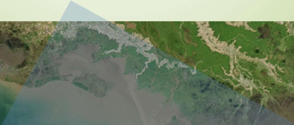
2 Freshwater Runoff in the Ocean Puerto Rico Puerto Rico Florida Ocean dynamics near the coast and offshore are altered by incoming freshwater Multi-scale processes Florida 2


3 The Problem Global, Relocatable coastal ocean prediction capability uses a Global River Database Propulsion Systems Glider Deployments Monthly mean discharges Acoustic Propagation Fixed, coarse, resolution No rainfallrunoff events 3

 Salinity (ppt)")

4 The Problem Freshwater is not adequately accounted for in regional or coastal operational Navy ocean models Coupled NCOM-SWAN Surface Salinity Mean Surface Salinity ( ) Salinity (ppt) Salinities of freshwater in the bay and throughout the coastal zone are too high!! Trident Warrior, Jul. 2013, Chesapeake Bay 4


5 Approach How do we get more accurate quantities of freshwater to the ocean? Hydrology-Ocean Model Coupling Hydrology Model Components Inter-tidal Zones Rainfall Estuary Rivers Land Surface Model Overland Flow/River Routing 5
6 Atmosphere-Hydrology Model ONR NOPP Coupling ATM COAMPS HYDRO LIS WRF-Hydro flow time 6

7 Hydrology-Ocean Model ONR NOPP Coupling ATM COAMPS HYDRO LIS WRF-Hydro flow time OCEAN Coastal NCOM Regional NCOM 10 1km 7
8 Hydrology-Ocean Model HYDRO COAMPS Satellite-derived Precipitation WRF-Hydro Coupling soil moisture land cover/use topography Coastal NCOM m OCEAN Regional NCOM 100m - 1 km 8
9 Satellite-Based Precipitation Accurate precipitation estimates Efficiency gains in using an external source of rainfall Flexibility to evaluate the effects of latency and resolution on freshwater reaching the coastal ocean

 - PMW or radar rain retrievals used as calibrator")
10 Satellite-Based Precipitation JAXA GSmap Precipitation hourly rainfall, 0.1 deg. res. a blended PMW+radar and IR sensors + surface rain gauge measurements NASA GPM Precipitation Global, 30 min. rainfall, 0.1 deg. res. Integrated, multi-satellite retrievals for GPM data (IMERG) - PMW or radar rain retrievals used as calibrator for IR rain retrievals Hourly Gsmap rainfall Mar-Dec 2000 Example of IMERG 7-day rainfall accumulation April 24-May 1, 2017


11 Surface Hydrology WRF-Hydro Terrain Routing Models: Overland, subsurface flow Channel & Reservoir Routing Models: Hydrologic and Hydraulic 3 overland flow schemes 4 baseflow flow schemes Output Variables: Stream Inflow, Surface Water Depth, Groundwater Depth, Soil Moisture 4 channel flow schemes Output Variables: Streamflow, River Stage, Flow Velocity, Reservoir Storage & Discharge multi-scale, multi-resolution, portable/scalable across computing platforms
. sigma generalized, z-levels allow partial cells.")

12 Navy Coastal Ocean Model Flexible variant of the Princeton Ocean Model (POM). Options for vertical coordinate: all sigma, all z-level, or a mixture of the two (hybrid). sigma generalized, z-levels allow partial cells. Choices of mixing formulations. Choices of boundary conditions (Flather, Orlanski, etc.) Tide, river, and wind forcing. Code structure consistent with COAMPS. Scaleable and efficient on a variety of computers. ESMF extensions added for coupling efforts. Wetting/drying implemented based on Oey (2005, 2006) Allard et al The US Navy coupled ocean-wave prediction system. Oceanography 27(3):92 103,


13 Application: Hurricane Irene Maximum Rainfall and Storm Surge Best track positions for Hurricane Irene, August Rainfall totals associated with Hurricane Irene. Selected storm surge values in feet associated with Hurricane Irene

14 Application: Hurricane Irene Satellite Precipitation (GSMap) H. Irene Rainfall Rate 28 Aug Japanese GSMaP Satellite, ~ 10km resolution, hourly

15 Application: Hurricane Irene GSMap Spatial Error Distribution Comparisons to NOAA Stage IV Hourly Rainfall Downscaled: 4 km to ~ 10 km Period: 1 Jun 31 Aug 2011 Mean error < 5%


16 Application: Hurricane Irene WRF-Hydro Uncalibrated Streamflow Comparisons Jul-Sep, 2011 Delaware Model Data Domain, 2011 USGS hydrologic units that drain to Chesapeake Bay Gridded channel routing being used Susquehanna Neuse Potomac James Courtesy of Aubrey Dugger (NCAR)

 500 m resolution 50 vertical")
17 Application: Hurricane Irene Navy Coastal Ocean Model (NCOM) Operational US East Domain for IC/BC ~ 3.8km resolution 49 layers climatological rivers NOAA Coastal Relief Map (3 arc sec ~ 90m) 500 m resolution 50 vertical levels (30 sigma, 20 z)
18 Application: Hurricane Irene Navy Coastal Ocean Model (NCOM) April September rivers, monthly mean data COAMPS West Atlantic 0.2 deg turned off moisture flux Wetting/drying 0.2 m upper layer depth 2.0 m min. depth Surface Salinity 28 Aug :00

19 Application: Hurricane Irene Navy Coastal Ocean Model (NCOM) Preliminary Experiments Offline one-way coupling Exchange streamflux only Compare simulations using: - monthly mean discharges - USGS hourly discharges - WRF-Hydro streamflow Surface Salinity 28 Aug :00

20 Hydrology-Ocean Model Coupling Technical Challenges WRF-Hydro Hydrology Model NCOM Coastal Ocean Model Placement and resolution of the land-margin interface Dynamically consistent spatial exchange of information Temporallyintegrated coupling for efficiency 20


21 Hydrology-Ocean Model Coupling What is optimal placement and resolution of hydrology-ocean coupling interface? INLAND SHORELINE 21
22 Hydrology-Ocean Model Coupling Dynamically Consistent Spatial Coupling Apply hydrology model fluxes via a distributed flux boundary condition within the coastal model Accommodate inland propagating tides and surge within the coupler 22


23 Hydrology-Ocean Model Coupling Develop Efficiency in the Coupler WRF-Hydro Hydrology Model Exchange water levels, water flux, temperature NCOM Coastal Ocean Model Coupler Dt = sec Dt = hours Accumulate freshwater from rainfall-runoff over event time scales? Dt = sec 23
24 Summary Issues for Hydrology-Ocean Model Coupling Location of the hydrology-ocean model exchange interface Temporal frequency of the exchange Consistency in the topography/bathymetry information across the two models What about wind over the land? Availability of global, high resolution databases to initialize the hydrology model
The Delaware Environmental Monitoring & Analysis Center
 The Delaware Environmental Monitoring & Analysis Center Tina Callahan Delaware Estuary Science & Environmental Summit 2013 January 27-30, 2013 What is DEMAC? Delaware Environmental Monitoring & Analysis
John Kindle. Sergio derada Igor Shulman Ole Martin Smedstad Stephanie Anderson. Data Assimilation in Coastal Modeing April
 John Kindle Sergio derada Igor Shulman Ole Martin Smedstad Stephanie Anderson Data Assimilation in Coastal Modeing April 3 2007 MODELS Motivation: Global->Coastal Real-Time Regional Coastal Models Global
APPLICATIONS OF DOWNSCALING: HYDROLOGY AND WATER RESOURCES EXAMPLES
 APPLICATIONS OF DOWNSCALING: HYDROLOGY AND WATER RESOURCES EXAMPLES Dennis P. Lettenmaier Department of Civil and Environmental Engineering For presentation at Workshop on Regional Climate Research NCAR
Hurricane Floyd Symposium. Satellite Precipitation as a Tool to Reanalyze Hurricane Floyd and Forecast Probabilities of Extreme Rainfall
 Sept. 18, 2009 Hurricane Floyd Symposium Scott Curtis, East Carolina Universtiy Satellite Precipitation as a Tool to Reanalyze Hurricane Floyd and Forecast Probabilities of Extreme Rainfall What was the
Nested coupled air/sea modeling for multi-scale processes in the Maritime Continent
 Nested coupled air/sea modeling for multi-scale processes in the Maritime Continent Julie Pullen Stevens Institute of Technology Arnold Gordon Columbia University Maria Flatau & James Doyle Naval Research
WIND EFFECTS ON CHEMICAL SPILL IN ST ANDREW BAY SYSTEM
 WIND EFFECTS ON CHEMICAL SPILL IN ST ANDREW BAY SYSTEM PETER C. CHU, PATRICE PAULY Naval Postgraduate School, Monterey, CA93943 STEVEN D. HAEGER Naval Oceanographic Office, Stennis Space Center MATHEW
Numerical Simulation System for Environmental Studies: SPEEDI-MP
 System for Prediction of Environmental Emergency Dose Information Multi-model Package 1/18 Numerical Simulation System for Environmental Studies: SPEEDI-MP Research Group for Environmental Science, Japan
Global Flash Flood Guidance System Status and Outlook
 Global Flash Flood Guidance System Status and Outlook HYDROLOGIC RESEARCH CENTER San Diego, CA 92130 http://www.hrcwater.org Initial Planning Meeting on the WMO HydroSOS, Entebbe, Uganda 26-28 September
Ocean Model Development for COAMPS
 Ocean Model Development for COAMPS Paul Martin Naval Research Laboratory Stennis Space Center, MS 39529 phone: (228) 688-5447 fax: (228) 688-4759 email: martin@nrlssc.navy.mil Award #: N0001401WX20609
Developing Coastal Ocean Forecasting Systems and Their Applications
 Developing Coastal Ocean Forecasting Systems and Their Applications Xiaochun Wang a,b LASG/IAP, CAS, July 23, 2010 Contributions from: JPL Yi Chao, John Farrara, Peggy Li, Zhijin Li, Quoc Vu, Hongchun
Flash Flood Guidance System On-going Enhancements
 Flash Flood Guidance System On-going Enhancements Hydrologic Research Center, USA Technical Developer SAOFFG Steering Committee Meeting 1 10-12 July 2017 Jakarta, INDONESIA Theresa M. Modrick Hansen, PhD
Using a high-resolution ensemble modeling method to inform risk-based decision-making at Taylor Park Dam, Colorado
 Using a high-resolution ensemble modeling method to inform risk-based decision-making at Taylor Park Dam, Colorado Michael J. Mueller 1, Kelly Mahoney 2, Kathleen Holman 3, David Gochis 4 1 Cooperative
HYCOM Caspian Sea Modeling. Part I: An Overview of the Model and Coastal Upwelling. Naval Research Laboratory, Stennis Space Center, USA
 HYCOM Caspian Sea Modeling. Part I: An Overview of the Model and Coastal Upwelling By BIROL KARA, ALAN WALLCRAFT AND JOE METZGER Naval Research Laboratory, Stennis Space Center, USA MURAT GUNDUZ Institute
Chiang Rai Province CC Threat overview AAS1109 Mekong ARCC
 Chiang Rai Province CC Threat overview AAS1109 Mekong ARCC This threat overview relies on projections of future climate change in the Mekong Basin for the period 2045-2069 compared to a baseline of 1980-2005.
Estimating the Mean Temperature and Salinity of the Chesapeake Bay Mouth
 Estuaries Vol. 25, No. 1, p. 1 5 February 2002 Estimating the Mean Temperature and Salinity of the Chesapeake Bay Mouth RICARDO A. LOCARNINI,LARRY P. ATKINSON*, and ARNOLDO VALLE-LEVINSON Center for Coastal
Ocean Model Development for COAMPS
 Ocean Model Development for COAMPS Paul Martin Naval Research Laboratory Stennis Space Center, MS 39529 phone: (228) 688-5447 fax: (228) 688-4759 email: martin@nrlssc.navy.mil Award #: N0001498WX30328
Analysis of Radar-Rainfall Uncertainties and effects on Hydrologic Applications. Emad Habib, Ph.D., P.E. University of Louisiana at Lafayette
 Analysis of Radar-Rainfall Uncertainties and effects on Hydrologic Applications Emad Habib, Ph.D., P.E. University of Louisiana at Lafayette Motivation Rainfall is a process with significant variability
PS4a: Real-time modelling platforms during SOP/EOP
 PS4a: Real-time modelling platforms during SOP/EOP Mistral Tramontane Bora Etesian Major sites of dense water formation Major sites of deep water formation influence of coastal waters Chairs: G. Boni,
Drought Monitoring with Hydrological Modelling
 st Joint EARS/JRC International Drought Workshop, Ljubljana,.-5. September 009 Drought Monitoring with Hydrological Modelling Stefan Niemeyer IES - Institute for Environment and Sustainability Ispra -
Topics 1. IOOS on the US East Coast. 2. Regional Physical & Ecosystem Modeling Efforts
 Topics 1. IOOS on the US East Coast National Federation of Regional Associations http://usnfra.org - NERACOOS - MACOORA 2. Regional Physical & Ecosystem Modeling Efforts Northeast Regional Association
Impacts of climate change on flooding in the river Meuse
 Impacts of climate change on flooding in the river Meuse Martijn Booij University of Twente,, The Netherlands m.j.booij booij@utwente.nlnl 2003 in the Meuse basin Model appropriateness Appropriate model
Advances in Coastal Inundation Simulation Using Unstructured-Grid Coastal Ocean Models
 Advances in Coastal Inundation Simulation Using Unstructured-Grid Coastal Ocean Models Bob Beardsley (WHOI) Changsheng Chen (UMass-Dartmouth) Bob Weisberg (U. South Florida) Joannes Westerink (U. Notre
Data Assimilation and Diagnostics of Inner Shelf Dynamics
 DISTRIBUTION STATEMENT A. Approved for public release; distribution is unlimited. Data Assimilation and Diagnostics of Inner Shelf Dynamics Emanuele Di Lorenzo School of Earth and Atmospheric Sciences
Yi Chao Jet Propulsion Laboratory California Institute of Technology & Joint Institute for Regional Earth System Science and Engineering (JIFRESSE)
") Strategy to Develop a 3D Ocean Circulation Forecasting System for Cook Inlet Yi Chao Jet Propulsion Laboratory California Institute of Technology & Joint Institute for Regional Earth System Science and
Strategy to Develop a 3D Ocean Circulation Forecasting System for Cook Inlet Yi Chao Jet Propulsion Laboratory California Institute of Technology & Joint Institute for Regional Earth System Science and
Florida Commission on Hurricane Loss Projection Methodology Flood Standards Development Committee. October 30, 2014
 Florida Commission on Hurricane Loss Projection Methodology Flood Standards Development Committee October 30, 2014 KatRisk LLC 752 Gilman St. Berkeley, CA 94710 510-984-0056 www.katrisk.com About KatRisk
Xiaodong Hong 1*, James Doyle 1, Richard M. Hodur 1, and Paul J. Martin 2
 4.5 APPLICATION OF COAMPS TM OCEAN DATA ASSIMILATIONS IN THE AOSN II MONTEREY BAY Xiaodong Hong 1*, James Doyle 1, Richard M. Hodur 1, and Paul J. Martin 2 1 Naval Research Laboratory, Monterey, CA 93943
An Overview of Operations at the West Gulf River Forecast Center Gregory Waller Service Coordination Hydrologist NWS - West Gulf River Forecast Center
 National Weather Service West Gulf River Forecast Center An Overview of Operations at the West Gulf River Forecast Center Gregory Waller Service Coordination Hydrologist NWS - West Gulf River Forecast
Talk Overview. Concepts. Climatology. Monitoring. Applications
 Atmospheric Rivers Talk Overview Concepts Climatology Monitoring Applications Satellite View Where is the storm? Where is the impact? Atmospheric Rivers Plume or fire hose of tropical moisture Heavy precipitation
Haiti and Dominican Republic Flash Flood Initial Planning Meeting
 Dr Rochelle Graham Climate Scientist Haiti and Dominican Republic Flash Flood Initial Planning Meeting September 7 th to 9 th, 2016 Hydrologic Research Center http://www.hrcwater.org Haiti and Dominican
Simulation of storm surge and overland flows using geographical information system applications
 Coastal Processes 97 Simulation of storm surge and overland flows using geographical information system applications S. Aliabadi, M. Akbar & R. Patel Northrop Grumman Center for High Performance Computing
IMPACT OF GROUND-BASED GPS PRECIPITABLE WATER VAPOR AND COSMIC GPS REFRACTIVITY PROFILE ON HURRICANE DEAN FORECAST. (a) (b) (c)
 (b) (c)") 9B.3 IMPACT OF GROUND-BASED GPS PRECIPITABLE WATER VAPOR AND COSMIC GPS REFRACTIVITY PROFILE ON HURRICANE DEAN FORECAST Tetsuya Iwabuchi *, J. J. Braun, and T. Van Hove UCAR, Boulder, Colorado 1. INTRODUCTION
9B.3 IMPACT OF GROUND-BASED GPS PRECIPITABLE WATER VAPOR AND COSMIC GPS REFRACTIVITY PROFILE ON HURRICANE DEAN FORECAST Tetsuya Iwabuchi *, J. J. Braun, and T. Van Hove UCAR, Boulder, Colorado 1. INTRODUCTION
The North Carolina State University coastal and estuary storm surge and flood prediction system
 The North Carolina State University coastal and estuary storm surge and flood prediction system L. J. Pietrafesa, L. Xie, D. A. Dickey, M. C. Peng & S. Yan College of Physical & Mathematical Sciences,
Coastal Hazard Assessment for the Lowermost Mississippi River Management Program
 Coastal Hazard Assessment for the Lowermost Mississippi River Management Program USACE ERDC Coastal and Hydraulics Laboratory Mary Cialone Chris Massey Norberto Nadal USACE Mississippi Valley Division
Flash Flood Flash Flood Forecasting and Early Warning System (FFEWS)
") Stakeholder Workshop of Haor Area Livelihoods Improvement Project (HALIP) 15 January 2016, Sunamganj, Bangladesh Flash Flood Flash Flood Forecasting and Early Warning System (FFEWS) BUET Study Team Prof
Stakeholder Workshop of Haor Area Livelihoods Improvement Project (HALIP) 15 January 2016, Sunamganj, Bangladesh Flash Flood Flash Flood Forecasting and Early Warning System (FFEWS) BUET Study Team Prof
Regional offline land surface simulations over eastern Canada using CLASS. Diana Verseghy Climate Research Division Environment Canada
 Regional offline land surface simulations over eastern Canada using CLASS Diana Verseghy Climate Research Division Environment Canada The Canadian Land Surface Scheme (CLASS) Originally developed for the
Evaluation of Satellite Precipitation Products over the Central of Vietnam
 Evaluation of Satellite Precipitation Products over the Central of Vietnam Long Trinh-Tuan (1), Jun Matsumoto (1,2), Thanh Ngo-Duc (3) (1) Department of Geography, Tokyo Metropolitan University, Japan.
NATIONAL HYDROPOWER ASSOCIATION MEETING. December 3, 2008 Birmingham Alabama. Roger McNeil Service Hydrologist NWS Birmingham Alabama
 NATIONAL HYDROPOWER ASSOCIATION MEETING December 3, 2008 Birmingham Alabama Roger McNeil Service Hydrologist NWS Birmingham Alabama There are three commonly described types of Drought: Meteorological drought
Chapter 5 CALIBRATION AND VERIFICATION
 Chapter 5 CALIBRATION AND VERIFICATION This chapter contains the calibration procedure and data used for the LSC existing conditions model. The goal of the calibration effort was to develop a hydraulic
A Cloud-Based Flood Warning System For Forecasting Impacts to Transportation Infrastructure Systems
 A Cloud-Based Flood Warning System For Forecasting Impacts to Transportation Infrastructure Systems Jon Goodall Associate Professor, Civil and Environmental Engineering Associate Director, Link Lab April
The Scale-dependence of Groundwater Effects on Precipitation and Temperature in the Central United States
 The Scale-dependence of Groundwater Effects on Precipitation and Temperature in the Central United States Michael Barlage, Fei Chen, Changhai Liu NCAR/RAL Gonzalo Miguez-Macho U. Santiago de Compostela
Evaluation of MPE Radar Estimation Using a High Density Rain Gauge Network within a Hydro-Estimator Pixel and Small SubWatershed
 Evaluation of MPE Radar Estimation Using a High Density Rain Gauge Network within a Hydro-Estimator Pixel and Small SubWatershed ALEJANDRA M. ROJAS GONZÁLEZ 1, ERIC W. HARMSEN 2 AND SANDRA CRUZ POL 3 1
HURRICANE JEANNE CHARACTERISTICS and STORM TIDE EVALUATION
 HURRICANE JEANNE CHARACTERISTICS and STORM TIDE EVALUATION ((DRAFT)) By Robert Wang and Michael Manausa Sponsored by Florida Department of Environmental Protection, Bureau of Beaches and Coastal Systems
Recent Developments in the Navy Coastal Ocean Model and its application as the ocean component in regional coupled forecast models
 Recent Developments in the Navy Coastal Ocean Model and its application as the ocean component in regional coupled forecast models Tommy Jensen, Paul Martin, Clark Rowley, Tim Campbell, Richard Allard,
The Hydrologic Cycle
 The Hydrologic Cycle Monthly precipitation for the central Arctic Ocean based on data from the Russian North Pole manned camps with daily bias adjustments. Raw precipitation totals are shown along with
Operational Estuarine & Coastal Forecast Systems in NOAA s. National Ocean Service
 Operational Estuarine & Coastal Forecast Systems in NOAA s. National Ocean Service Eugene Wei, Frank Aikman III and Richard Patchen NOAA S S National Ocean Service Workshop on: Data Assimilation in Support
January 25, Summary
 January 25, 2013 Summary Precipitation since the December 17, 2012, Drought Update has been slightly below average in parts of central and northern Illinois and above average in southern Illinois. Soil
Tracking Storm Tide and Coastal Flooding During Hurricane Matthew
 Tracking Storm Tide and Coastal Flooding During Hurricane Matthew Stephen Harden, Jeanne Robbins, and Eric Frantz U.S. Geological Survey, South Atlantic Water Science Center Presented to: WRRI Annual Conference
Merced Irrigation District Hydrologic and Hydraulic Operations (MIDH2O) Model
 Model") Merced Irrigation District Hydrologic and Hydraulic Operations (MIDH2O) Model September 05, 2018 Marco Bell, Merced Irrigation District Bibek Joshi, Dewberry Objective Introduce HEC-RTS Benefits of MIDH2O
Merced Irrigation District Hydrologic and Hydraulic Operations (MIDH2O) Model September 05, 2018 Marco Bell, Merced Irrigation District Bibek Joshi, Dewberry Objective Introduce HEC-RTS Benefits of MIDH2O
UNDERSTANDING STORM TIDES
 UNDERSTANDING STORM TIDES Run from the water, hide from the wind.. CATEGORY CATEGORY CATEGORY CATEGORY CATEGORY 1 2 3 4 5 WIND 74-95 mph 64-82 knots 96-110 mph 83-95 knots 111-130 mph 96-113 knots 131-155
Ensuring Water in a Changing World
 Ensuring Water in a Changing World Evaluation and application of satellite-based precipitation measurements for hydro-climate studies over mountainous regions: case studies from the Tibetan Plateau Soroosh
Cold air outbreak over the Kuroshio Extension Region
 Cold air outbreak over the Kuroshio Extension Region Jensen, T. G. 1, T. Campbell 1, T. A. Smith 1, R. J. Small 2 and R. Allard 1 1 Naval Research Laboratory, 2 Jacobs Engineering NRL, Code 7320, Stennis
Global Precipitation Data Sets
 Global Precipitation Data Sets Rick Lawford (with thanks to Phil Arkin, Scott Curtis, Kit Szeto, Ron Stewart, etc) April 30, 2009 Toronto Roles of global precipitation products in drought studies: 1.Understanding
GIS Techniques for Floodplain Delineation. Dean Djokic
 GIS Techniques for Floodplain Delineation Dean Djokic (ddjokic@esri.com) Content What is a floodplain? How to get a floodplain? What can GIS do for floodplain modeling? Simple GIS techniques for floodplain
Coupled Wind, Wave, and Surge Modeling. Pat Welsh University of North Florida 10th International Wave Conference 12 November 2007
 Coupled Wind, Wave, and Surge Modeling Pat Welsh University of North Florida 10th International Wave Conference 12 November 2007 Current AWIS Lab Project & Proposals Collaborators Our Lab is too small
Stream Discharge and the Water Budget
 Regents Earth Science Unit 6: Water Cycle & Climate Name: Lab # Stream Discharge and the Water Budget Introduction: The United States Geological Survey (USGS) measures and publishes values for the daily
NWS Operational Marine and Ocean Forecasting. Overview. Ming Ji. Ocean Prediction Center National Weather Service/NCEP. CIOSS/CoRP
 NWS Operational Marine and Ocean Forecasting Overview Ming Ji Ocean Prediction Center National Weather Service/NCEP CIOSS/CoRP CoRP Symposium Corvallis, OR Aug. 12-13, 13, 2008 Titanic Telegram Marine
HYCOM and GODAE in Relation to Navy Ocean Prediction
 HYCOM and GODAE in Relation to Navy Ocean Prediction An Overview Presented by Harley Hurlburt Naval Research Laboratory Stennis Space Center, MS 39529-5004 5004 HYCOM Meeting Naval Research Laboratory
EFFICIENCY OF THE INTEGRATED RESERVOIR OPERATION FOR FLOOD CONTROL IN THE UPPER TONE RIVER OF JAPAN CONSIDERING SPATIAL DISTRIBUTION OF RAINFALL
 EFFICIENCY OF THE INTEGRATED RESERVOIR OPERATION FOR FLOOD CONTROL IN THE UPPER TONE RIVER OF JAPAN CONSIDERING SPATIAL DISTRIBUTION OF RAINFALL Dawen YANG, Eik Chay LOW and Toshio KOIKE Department of
A WATER CYCLE PREDICTION SYSTEM
 A WATER CYCLE PREDICTION SYSTEM FOR THE GREAT LAKES AND ST. LAWRENCE RIVER V. Fortin 1, D. Durnford 2, G. Smith 1, P. Matte 1, M. Mackay 1, N. Bernier 1... and many others 1 Meteorological Research Division,
Flood Forecasting Tools for Ungauged Streams in Alberta: Status and Lessons from the Flood of 2013
 Flood Forecasting Tools for Ungauged Streams in Alberta: Status and Lessons from the Flood of 2013 John Pomeroy, Xing Fang, Kevin Shook, Tom Brown Centre for Hydrology, University of Saskatchewan, Saskatoon
Texas Alliance of Groundwater Districts Annual Summit
 Texas Alliance of Groundwater Districts Annual Summit Using Remote-Sensed Data to Improve Recharge Estimates August 28, 2018 by Ronald T. Green1, Ph.D., P.G. and Stu Stothoff2, Ph.D., P.G. Earth Science
Quantitative Flood Forecasts using Short-term Radar Nowcasting
 Quantitative Flood Forecasts using Short-term Radar Nowcasting Enrique R. Vivoni *, Dara Entekhabi *, Rafael L. Bras *, Matthew P. Van Horne *, Valeri Y. Ivanov *, Chris Grassotti + and Ross Hoffman +
Study of Hydrometeorology in a Hard Rock Terrain, Kadirischist Belt Area, Anantapur District, Andhra Pradesh
 Open Journal of Geology, 2012, 2, 294-300 http://dx.doi.org/10.4236/ojg.2012.24028 Published Online October 2012 (http://www.scirp.org/journal/ojg) Study of Hydrometeorology in a Hard Rock Terrain, Kadirischist
Application of Satellite Data for Flood Forecasting and Early Warning in the Mekong River Basin in South-east Asia
 MEKONG RIVER COMMISSION Vientiane, Lao PDR Application of Satellite Data for Flood Forecasting and Early Warning in the Mekong River Basin in South-east Asia 4 th World Water Forum March 2006 Mexico City,
OCEAN MODELING. Joseph K. Ansong. (University of Ghana/Michigan)
") OCEAN MODELING Joseph K. Ansong Email: jkansong@umich.edu (University of Ghana/Michigan) OUTLINE INTRODUCTION MOTIVATION EQUATIONS OF MOTION INTRODUCTION TO ROMS (Regional Ocean Modeling System) EXAMPLES
OCEAN MODELING Joseph K. Ansong Email: jkansong@umich.edu (University of Ghana/Michigan) OUTLINE INTRODUCTION MOTIVATION EQUATIONS OF MOTION INTRODUCTION TO ROMS (Regional Ocean Modeling System) EXAMPLES
Inter comparison of wave height observations from buoy and altimeter with numerical prediction
 Indian Journal of Geo-Marine Sciences Vol. 43(7), July 2014, pp. 1347-1351 Inter comparison of wave height observations from buoy and altimeter with numerical prediction S. A. Sannasiraj 1*, M. Kalyani
The Properties of Convective Clouds Over the Western Pacific and Their Relationship to the Environment of Tropical Cyclones
 The Properties of Convective Clouds Over the Western Pacific and Their Relationship to the Environment of Tropical Cyclones Principal Investigator: Dr. Zhaoxia Pu Department of Meteorology, University
July, International SWAT Conference & Workshops
 July, 212 212 International SWAT Conference & Workshops Hydrological Modelling of Kosi and Gandak Basins using SWAT Model S. Dutta, Pritam Biswas, Sangita Devi, Suresh A Karth and Bimlesh kumar, Ganga
P1M.4 COUPLED ATMOSPHERE, LAND-SURFACE, HYDROLOGY, OCEAN-WAVE, AND OCEAN-CURRENT MODELS FOR MESOSCALE WATER AND ENERGY CIRCULATIONS
 P1M.4 COUPLED ATMOSPHERE, LAND-SURFACE, HYDROLOGY, OCEAN-WAVE, AND OCEAN-CURRENT MODELS FOR MESOSCALE WATER AND ENERGY CIRCULATIONS Haruyasu NAGAI *, Takuya KOBAYASHI, Katsunori TSUDUKI, and Kyeongok KIM
Three main areas of work:
 Task 2: Climate Information 1 Task 2: Climate Information Three main areas of work: Collect historical and projected weather and climate data Conduct storm surge and wave modeling, sea-level rise (SLR)
The Huong River the nature, climate, hydro-meteorological issues and the AWCI demonstration project
 The Huong River the nature, climate, hydro-meteorological issues and the AWCI demonstration project 7th GEOSS AP Symposium, the AWCI parallel session May 27, 214, Tokyo National Centre for Hydro-Meteorological
Eric. W. Harmsen 1, John Mecikalski 2, Vanessa Acaron 3 and Jayson Maldonado 3
 Estimating Ground-Level Solar Radiation and Evapotranspiration In Puerto Rico Using Satellite Remote Sensing Eric. W. Harmsen 1, John Mecikalski 2, Vanessa Acaron 3 and Jayson Maldonado 3 1 Department
A Rapidly Relocatable, Coupled Mesoscale Modeling System for Naval Special Warfare
 A Rapidly Relocatable, Coupled Mesoscale Modeling System for Naval Special Warfare Richard Allard Naval Research Laboratory Code 7322, Bldg. 1009 John C. Stennis Space Center SSC MS 39529 Phone: (228)
Why Hydrological Services are Important to Business
 Why Hydrological Services are Important to Business Dr. David Green Program Manager, Disasters Earth Science Division David.s.green@nasa.gov May 8, 2018 2 Communities and Areas of Intensive Risk Socio-Economic
Physical Processes: What have we learned about Florida Bay in the past five years, and how is that useful to CERP planning and SFER management?
 Physical Processes: What have we learned about Florida Bay in the past five years, and how is that useful to CERP planning and SFER management? Peter B. Ortner, UM/RSMAS/CIMAS Modeling Progress Statistical
Land Data Assimilation at NCEP NLDAS Project Overview, ECMWF HEPEX 2004
 Dag.Lohmann@noaa.gov, Land Data Assimilation at NCEP NLDAS Project Overview, ECMWF HEPEX 2004 Land Data Assimilation at NCEP: Strategic Lessons Learned from the North American Land Data Assimilation System
Assessing bias in satellite rainfall products and their impact in water balance closure at the Zambezi headwaters
 Assessing bias in satellite rainfall products and their impact in water balance closure at the Zambezi headwaters Omondi C.K. 1 Rientjes T.H.M. 1, Haile T.A. 2, Gumindoga W. 1,3 (1) Faculty ITC, University
HURRICANE FRANCES CHARACTERISTICS and STORM TIDE EVALUATION
 HURRICANE FRANCES CHARACTERISTICS and STORM TIDE EVALUATION ((DRAFT)) By Robert Wang and Michael Manausa Sponsored by Florida Department of Environmental Protection, Bureau of Beaches and Coastal Systems
Central Asia Regional Flash Flood Guidance System 4-6 October Hydrologic Research Center A Nonprofit, Public-Benefit Corporation
 http://www.hrcwater.org Central Asia Regional Flash Flood Guidance System 4-6 October 2016 Hydrologic Research Center A Nonprofit, Public-Benefit Corporation FFGS Snow Components Snow Accumulation and
Inflow Forecasting for Hydro Catchments. Ross Woods and Alistair McKerchar NIWA Christchurch
 Inflow Forecasting for Hydro Catchments Ross Woods and Alistair McKerchar NIWA Christchurch Inflows Water flowing into hydro storages Usually measured by monitoring the levels and outflows from hydro storages
INTRODUCTION TO HEC-HMS
 INTRODUCTION TO HEC-HMS Hydrologic Engineering Center- Hydrologic Modeling System US Army Corps of Engineers Hydrologic Engineering Center HEC-HMS Uses Schematics Enter properties: watershed, rivers (reaches),
REDWOOD VALLEY SUBAREA
 Independent Science Review Panel Conceptual Model of Watershed Hydrology, Surface Water and Groundwater Interactions and Stream Ecology for the Russian River Watershed Appendices A-1 APPENDIX A A-2 REDWOOD
Rainfall Observations in the Loxahatchee River Watershed
 Rainfall Observations in the Loxahatchee River Watershed Richard C. Dent Loxahatchee River District September 1997 Introduction Rain is a common occurrence in south Florida, yet its presence or absence
Future climate change in the Antilles: Regional climate, tropical cyclones and sea states
 Future climate change in the Antilles: Regional climate, tropical cyclones and sea states Ali Belmadani Météo-France Antilles-Guiana (DIRAG), Martinique Acknowledgements: P. Palany, R. Pilon, F. Chauvin,
Sea Level Variability in the Western North Pacific during the 20th Century
 Sea Level Variability in the Western North Pacific during the 20th Century Yoshi N. Sasaki (sasakiyo@sci.hokudai.ac.jp), R. Washizu, S. Minobe Hokkaido University, Japan T. Yasuda: Japan Meteorological
Discussion of forcing errors in the Bay and how to deal with these using the LETKF. Assimilation with synthetic obs with realistic coverage
 Discussion of forcing errors in the Bay and how to deal with these using the LETKF Assimilation with synthetic obs with realistic coverage Ecologically and economically important resource Home to over
COUPLED OCEAN-ATMOSPHERE 4DVAR
 COUPLED OCEAN-ATMOSPHERE 4DVAR Hans Ngodock, Matthew Carrier, Clark Rowley, Tim Campbell NRL, Stennis Space Center Clark Amerault, Liang Xu, Teddy Holt NRL, Monterey 11/17/2016 International workshop on
LOM Layered Ocean Model Workshop, 2-4 June 2015, Copenhagen
 LOM Layered Ocean Model Workshop, 2-4 June 2015, Copenhagen 2 HYCOM Preliminary operational system Grid 1/3 (22 levels) Spin-up COADS 30 years (USP-UFBA) 2007/2008 NCEP atmospheric forcing HYCOM Grid nesting
SMAP Winds. Hurricane Irma Sep 5, AMS 33rd Conference on Hurricanes and Tropical Meteorology Ponte Vedra, Florida, 4/16 4/20, 2018
 Intensity and Size of Strong Tropical Cyclones in 2017 from NASA's SMAP L-Band Radiometer Thomas Meissner, Lucrezia Ricciardulli, Frank Wentz, Remote Sensing Systems, Santa Rosa, USA Charles Sampson, Naval
Convective-scale NWP for Singapore
 Convective-scale NWP for Singapore Hans Huang and the weather modelling and prediction section MSS, Singapore Dale Barker and the SINGV team Met Office, Exeter, UK ECMWF Symposium on Dynamical Meteorology
Climate. Annual Temperature (Last 30 Years) January Temperature. July Temperature. Average Precipitation (Last 30 Years)
 January Temperature. July Temperature. Average Precipitation (Last 30 Years)") Climate Annual Temperature (Last 30 Years) Average Annual High Temp. (F)70, (C)21 Average Annual Low Temp. (F)43, (C)6 January Temperature Average January High Temp. (F)48, (C)9 Average January Low Temp.
Climate Annual Temperature (Last 30 Years) Average Annual High Temp. (F)70, (C)21 Average Annual Low Temp. (F)43, (C)6 January Temperature Average January High Temp. (F)48, (C)9 Average January Low Temp.
Impact assessment on disasters
 The 5th International Coordination Group (ICG) Meeting GEOSS Asian Water Cycle Initiative (AWCI), Dec. 16, 2009. Impact assessment on disasters Eiichi Nakakita Disaster Prevention Research Institute Kyoto
NRL Modeling in Support of ASAP MURI 2006 Experiment in the Monterey Bay
 NRL Modeling in Support of ASAP MURI 2006 Experiment in the Monterey Bay Igor Shulman Naval Research Laboratory Stennis Space Center, MS 39529 phone: (228) 688-5646 fax: (228) 688-7072; e-mail: igor.shulman@nrlssc.navy.mil
Savannah Harbor Expansion Project
 Savannah Harbor Expansion Project Evaluation of Hurricane Surge Impacts with Proposed Mitigation Plan December 2007 Introduction This report summarizes the results of hurricane surge impacts with implementation
Hyperlocal Marine Weather: What s Happening?
 Hyperlocal Marine Weather: What s Happening? André van der Westhuysen 1,2 and Jeff McQueen 1 1 NOAA / National Weather Service National Centers for Environmental Prediction 2 I.M Systems Group, Rockville
John Callahan (Delaware Geological Survey) Kevin Brinson, Daniel Leathers, Linden Wolf (Delaware Environmental Observing System)
 Kevin Brinson, Daniel Leathers, Linden Wolf (Delaware Environmental Observing System)") John Callahan (Delaware Geological Survey) Kevin Brinson, Daniel Leathers, Linden Wolf (Delaware Environmental Observing System) Delaware is extremely vulnerable to the impacts of coastal flooding Tropical
John Callahan (Delaware Geological Survey) Kevin Brinson, Daniel Leathers, Linden Wolf (Delaware Environmental Observing System) Delaware is extremely vulnerable to the impacts of coastal flooding Tropical
Comparative Analysis of Hurricane Vulnerability in New Orleans and Baton Rouge. Dr. Marc Levitan LSU Hurricane Center. April 2003
 Comparative Analysis of Hurricane Vulnerability in New Orleans and Baton Rouge Dr. Marc Levitan LSU Hurricane Center April 2003 In order to compare hurricane vulnerability of facilities located in different
FFGS Advances. Initial planning meeting, Nay Pyi Taw, Myanmar February, Eylon Shamir, Ph.D,
 FFGS Advances Initial planning meeting, Nay Pyi Taw, Myanmar 26-28 February, 2018 Eylon Shamir, Ph.D, EShamir@hrcwater.org Hydrologic Research Center San Diego, California FFG System Enhancements The following
Basins-Level Heavy Rainfall and Flood Analyses
 Basins-Level Heavy Rainfall and Flood Analyses Peng Gao, Greg Carbone, and Junyu Lu Department of Geography, University of South Carolina (gaop@mailbox.sc.edu, carbone@mailbox.sc.edu, jlu@email.sc.edu)
School on Modelling Tools and Capacity Building in Climate and Public Health April Rainfall Estimation
 2453-6 School on Modelling Tools and Capacity Building in Climate and Public Health 15-26 April 2013 Rainfall Estimation CECCATO Pietro International Research Institute for Climate and Society, IRI The