Global Precipitation Data Sets
|
|
|
- Mark Chase
- 6 years ago
- Views:
Transcription
1 Global Precipitation Data Sets Rick Lawford (with thanks to Phil Arkin, Scott Curtis, Kit Szeto, Ron Stewart, etc) April 30, 2009 Toronto
2 Roles of global precipitation products in drought studies: 1.Understanding climate processes: Precipitation plays an important role in removing moisture from the atmosphere. This affects the profile of atmospheric moisture and its horizontal distribution. 2. Estimating hydrologic impacts during droughts: Precipitation recharges surface water systems including soil moisture changes, effects on vegetation, ecosystems and societies and changes in ocean salinity. 3. Identifying the location and extent of drought. 4. Assessing the drought impacts on the atmospheric energy budget. 5. Assessing the accuracy of precipitation data is a limiting factor in our ability to close the global water budget during drought. 6. Evaluating modelled precipitation is a critical test for assessing the ability of climate models to address the wet part of the climate system. 7. Understanding the links between dry regimes and precipitationevents embedded in the drought event. 2002


 NWP models")
3 Scale is a major factor in monitoring and predicting precipitation. Larger scales must be understood to provide context and boundary conditions for local/regional drought. LOCAL CLOUD CONVECTIVE STORMS SYNOPTIC SCALES GLOBAL SCALE * * * V Turbulence Aircraft Radar Convection Radar TRMM CRMs ISSUE: Atmospheric Circulation Satellites (passive mw) NWP models Climate Variability/ Change Satellites GCMs Gauge
4 GLOBAL DATA SETS CONSIDERED IN THIS TALK 1. Global Precipitation Climatology Centre (GPCC) 2. Global Precipitation Climatology Project (GPCP) 3. CPC Merged Analysis of Precipitation (CMAP) 4. Global Satellite Mapping for Precipitation(GSMap) 5. NASA Tropical Rainfall Measuring Mission (TRMM) Multi-Satellite Precipitation Analysis Evaluation of global products The future: Global Precipitation Measurement (GPM)
.")

5 The Global Precipitation Climatology Centre (GPCC) is operated by the Deutscher Wetterdienst (DWD) since 1989 following the invitation of the World Meteorological Organisation (WMO). GPCC is integrated in the Global Climate Observing System (GCOS) and in the World Climate Research Programme (WCRP). The task of the GPCC is: GPCC to analyse monthly global land-surface precipitation in its spatio-temporal distribution based on in situ observed data. Non Near Real Time Obs Obs Green and blue colours indicate grids with data coverage sufficient to meet the GPCC criterion: Sampling error < 10 %

6 GPCC Products and User Applications Operational GPCC First Guess Product based application for the Global Drought Monitor of the UCL Hazard Research Center (Web:
7 GPCC Products Strengths: - Integrate most major global precipitation databases and of data contributions from most countries of the world >70,000 stations -Products are quality controlled and error assessment of observation data from different sources andrelated metadata - Applies specific analysis products Limitations: -Covers only land areas - Coverage is non-uniform -Allows access to data products but not the raw data
 Adler et al. (2003), J. Hydromet. Pentad, 2.")
 Huffman et al. (2001) J. Hydromet.")
8 GPCP Global Precipitation Products NASA, NOAA, DWD, UMD, CUHK, others Monthly, 2.5 Merged Analysis (1979-present) Adler et al. (2003), J. Hydromet. Pentad, 2.5 Merged Analysis (1979-present) Xie et al. (2003) J. Climate Daily, 1 Merged Analysis (1997-present) Huffman et al. (2001) J. Hydromet. 29-year Climatology ( produced ~ 3 months after observation time

9 (From 2008 report)

10 Global Precipitation Climatologies GPCP (left)/cmap (right) mean annual cycle and global mean time series Monthly/5-day; 2.5 lat/long global Both based on microwave/ir combined with gauges
11 Global Precipitation Climatology Project (GPCP) Strengths: 1.It provides global coverage including oceans as well as land. 2.The length of record (30 years) provides a basis for comparative analysis. Limitations: 1.The spatial resolution of the products have been too coarse to deal many types of extremes and applications although it seems to be adequate for drought. 2. The characterization of errors is incomplete, 3. Many of the techniques are dated because they are based on 1979 technologies. 4. It is a challenge to achieve temporal homogeneity in view of changing mix of satellites. The strengths and weaknesses of the CMAP products are very similar to those of GPCP products. However, differences do arise because CMAP products are Calibrated using data from different regions. In addition, CMAP uses an IR-based product derived from anomalies in OLR, and one version uses precipitation from the NCEP reanalysis as an additional input
 Meteosat - AVHRR Cloud anomalies (METEOSAT GEO) over the equatorial region show a stair-step when GEO sensors changed.")
12 DEVELOPING LONG-TERM HOMOGENEOUS DATA SETS FACTORS WORKING AGAINST HOMOGENEITY INCLUDE: -CHANGES IN SATELLITE PLATFORM -DETERIORATION OF SATELLITE FUNCTION OVER TIME (ORBIT DRIFT, SENSOR DEGRADATION, ETC) Meteosat - AVHRR Cloud anomalies (METEOSAT GEO) over the equatorial region show a stair-step when GEO sensors changed. (Campbell and von der Haar) GEWEX IS DEVELOPING PLANS FOR PRODUCT REANALYSIS THAT WILL LEAD TO BETTER TECHNIQUES FOR THE DEVELOPMENT OF HOMOGENEOUS DATA SETS FROM SATELLITE DATA.


13 The Tropical Rainfall Measuring Mission (TRMM) has now been providing high resolution data for 10 years TRMM was launched in November 1997 by NASA and JAXA with a space-borne radar and a high-resolution microwave imager on-board to improve tropical precipitation measurements from space. This mission was intended to last for 3 years. However, as a result of robust sensors and public opinion about the value of these data this system has continued to provide valuable information for the past decade. (Bob Adler) --see trmm.gsfc.nasa.gov

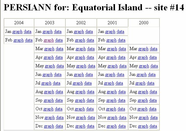
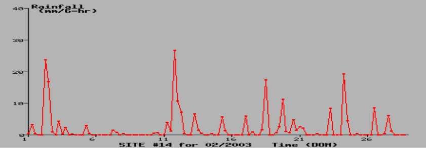
14 PERSIANN Data for CEOP Reference Sites o x 0.25 o lat/long scale 6-hour accumulated precipitation 2.5 o x2.5 o box
15 TRMM Multi-Satellite Precipitation Analysis Strengths: 1.High resolution allows for the identification of precipitation events that may be missed by the gauge network. 2. The active sensing provides 3-D imagery of the precipitation patterns. Limitations: 1.The record is only 10 years so it is relatively short for comparative studies. 2.The coverage only extends between 30N and 30S 3.The algorithm to go from the instantaneous measurements to rainfall amount has some significant limitations. 4. Products based on composites and therefore noisy
 and GCOM-W1/AMSR2. The goal of GSMaP is to produce high precision and high resolution global precipitation maps by using satellite-borne microwave radiometers (MWRs).")
16 GSMap (Global Satellite Mapping for Precipitation) an hourly global rainfall product GSMaP (Global Satellite Mapping for Precipitation) is; Currently produced by JAXA s Precipitation Measurement Missions (TRMM and GPM) and GCOM-W1/AMSR2. The goal of GSMaP is to produce high precision and high resolution global precipitation maps by using satellite-borne microwave radiometers (MWRs). Development of reliable MWR algorithm consistent with TRMM/PR and precipitation physical model developed by using PR (Aonashi et al., 2009). Combination of microwave radiometer retrievals with GEO IR by the moving vector and Kalman filtering method (Ushio et al., 2009). GSMaP provides daily 0.25-degree GSMaP_NRT data to regional precipitation validation sites (US, Australia, South America, etc.) by JAXA.


")
17 PMW Passive Microwave Radiometers GEO IR data Flowchart of GSMaP algorithm Present IR Zonal 1-hr before IR Cloud motion vectors Meridional Past PMW data 1-hr before PMW PMW interpolated by the motion vectors Kalman filter Present MWR data MWR data observed during present 1-hr (PMW overpasses) (Outsides PMW overpasses) Present Rain map (Ushio et al., 2009)
18 IPWG/IGWCO Program for the Evaluation of High Resolution Precipitation Products (PEHRPP) A comprehensive hypothesis-based collaborative effort to understand the capabilities and characteristics of these new HRPP (High Resolution Precipitation Products) Intercomparisons: Suite 1: Continental/Regional Comparisons Suite 2: High time resolution comparisons over selected limited regions Suite 3: Very high quality field program data sets Suite 4: "Big picture" comparisons Preliminary Results: Adding geostationary IR improves HRPP Morphing appears to work well more consistently than other methods of utilizing IR Adding monthly gauge information improves daily statistics Model forecasts of precipitation correspond better to gauge-based analyses in cold and/or high latitude regimes
19 Observations Many issues related to satellite-derived precipitation estimates: Solid precipitation snow, etc. Magnitude of tropical rainfall Light precipitation drizzle, fog, cloud liquid water Broader issues related to global precipitation data sets: Temporal stability critical to understanding global climate change Sustainability of integrated global precipitation data sets Sustainability of critical observations both satellite and in situ

20 The Global Precipitation Measurement (GPM) Mission Specifically designed to unify and advance precipitation measurements from a constellation of dedicated and operational satellites for research & applications advanced active & passive microwave measurements to establish a reference standard a consistent framework for inter-satellite calibration international collaboration in algorithm development and ground validation GPM Low-Inclination Observatory (NASA) for enhanced mid and low-latitude sampling 2 nd GMI at 40 o inclination and 635 km altitude Improved near real-time hurricane monitoring Partner Constellation Satellites: GCOM-W DMSP-F18, F19 Megha-Tropiques NOAA-N NPP MetOp-B NPOESS-C1 GPM Core Observatory (NASA-JAXA) serving as a physics observatory and a calibration reference Dual-frequency Precipitation Radar (DPR) at Ku-Ka bands and a GHz GPM Microwave Imager (GMI) at 65 o inclination and 407 km altitude Next-generation precipitation measurements Increased sensitivity for light rain and snow detection Better overall measurement accuracy Uniform calibration of brightness temperatures of Constellation sensors Detailed microphysical information and a common cloud database for rain & snow retrievals from Core and Constellation sensors


21 Data from the new CloudSat Mission opens a new era of active remote sensing Recently Cloudsat was launched. It measures the vertical structure of clouds and quantifies their ice and water contents as a step toward improved weather prediction and understanding of climatic processes. Cloudsat measures intensities of 0 1 mm/h which all other satellites cannot measure. Rain definite Rain probable Rain possible
22 (from Ron Stewart) November 12, 2007 horizontal resolution = 1 km A B
23 Model-derived estimates Precipitation is not a random occurrence -other atmospheric observations contain relevant information Atmospheric winds, temperature, moisture largely determine where precipitation falls and how much occurs Physically based dynamical models of the atmosphere predict/specify precipitation in various ways Numerical Weather Prediction models forecast precipitation Assimilation of radiances can yield cloud, hydrometeor distributions These can be used as estimates of precipitation Best where models best Accuracy strongly dependent on validity of modeled physical processes Examples: atmospheric reanalyses
24 Models give a range of results for simulated precipitation values (after Szeto)
 give about 2.6 mm/day (AR4 range is about 2.5-3.")

25 Global Mean Precipitation from Reanalyses and Reconstructions (differences largest over oceans) Datasets based on observations (GPCP, CMAP) give about 2.6 mm/day (AR4 range is about mm/day) Data assimilation products average about 3 mm/day; also have larger mean annual cycle and greater interannual variability than observation-based products ESRL-Compo/Whittaker SLP-based reanalysis is about 3.3 mm/day (figure courtesy Junye Chen, NASA/GMAO-MERRA)
26 Issues: 1. How can satellite data and integrated data products be most effectively used in the characterization of extremes? 2. How can Canada most effectively contribute to global precipitation products? 3. What types of precipitation data are most useful for the assimilation of precipitation in Canadian forecast models? 4. What type of research can Canada undertake to improve the ability to detect solid or light precipitation?
Remote sensing of precipitation extremes
 The panel is about: Understanding and predicting weather and climate extreme Remote sensing of precipitation extremes Climate extreme : (JSC meeting, June 30 2014) IPCC SREX report (2012): Climate Ali
APPENDIX 2 OVERVIEW OF THE GLOBAL PRECIPITATION MEASUREMENT (GPM) AND THE TROPICAL RAINFALL MEASURING MISSION (TRMM) 2-1
 AND THE TROPICAL RAINFALL MEASURING MISSION (TRMM) 2-1") APPENDIX 2 OVERVIEW OF THE GLOBAL PRECIPITATION MEASUREMENT (GPM) AND THE TROPICAL RAINFALL MEASURING MISSION (TRMM) 2-1 1. Introduction Precipitation is one of most important environmental parameters.
APPENDIX 2 OVERVIEW OF THE GLOBAL PRECIPITATION MEASUREMENT (GPM) AND THE TROPICAL RAINFALL MEASURING MISSION (TRMM) 2-1 1. Introduction Precipitation is one of most important environmental parameters.
GPM-GSMaP data is now available from JAXA G-portal (https://www.gportal.jaxa.jp) as well as current GSMaP web site (http://sharaku.eorc.jaxa.
 as well as current GSMaP web site (http://sharaku.eorc.jaxa.") GPM-GSMaP data is now available from JAXA G-portal (https://www.gportal.jaxa.jp) as well as current GSMaP web site (http://sharaku.eorc.jaxa.jp/ GSMaP/). GPM Core GMI TRMM PR GPM era Precipitation Radar
GPM-GSMaP data is now available from JAXA G-portal (https://www.gportal.jaxa.jp) as well as current GSMaP web site (http://sharaku.eorc.jaxa.jp/ GSMaP/). GPM Core GMI TRMM PR GPM era Precipitation Radar
Overview and Access to GPCP, TRMM, and GPM Precipitation Data Products
 National Aeronautics and Space Administration ARSET Applied Remote Sensing Training http://arset.gsfc.nasa.gov @NASAARSET Overview and Access to GPCP, TRMM, and GPM Precipitation Data Products www.nasa.gov
2009 Progress Report To The National Aeronautics and Space Administration NASA Energy and Water Cycle Study (NEWS) Program
 Program") 2009 Progress Report To The National Aeronautics and Space Administration NASA Energy and Water Cycle Study (NEWS) Program Proposal Title: Grant Number: PI: The Challenges of Utilizing Satellite Precipitation
2009 Progress Report To The National Aeronautics and Space Administration NASA Energy and Water Cycle Study (NEWS) Program Proposal Title: Grant Number: PI: The Challenges of Utilizing Satellite Precipitation
Welcome and Introduction
 Welcome and Introduction Riko Oki Earth Observation Research Center (EORC) Japan Aerospace Exploration Agency (JAXA) 7th Workshop of International Precipitation Working Group 17 November 2014 Tsukuba International
The Global Precipitation Climatology Project (GPCP) CDR AT NOAA: Research to Real-time Climate Monitoring
 CDR AT NOAA: Research to Real-time Climate Monitoring") The Global Precipitation Climatology Project (GPCP) CDR AT NOAA: Research to Real-time Climate Monitoring Robert Adler, Matt Sapiano, Guojun Gu University of Maryland Pingping Xie (NCEP/CPC), George Huffman
The Global Precipitation Climatology Project (GPCP) CDR AT NOAA: Research to Real-time Climate Monitoring Robert Adler, Matt Sapiano, Guojun Gu University of Maryland Pingping Xie (NCEP/CPC), George Huffman
TRMM Multi-satellite Precipitation Analysis (TMPA)
") TRMM Multi-satellite Precipitation Analysis (TMPA) (sometimes known as 3B42/43, TRMM product numbers) R. Adler, G. Huffman, D. Bolvin, E. Nelkin, D. Wolff NASA/Goddard Laboratory for Atmospheres with key
TRMM Multi-satellite Precipitation Analysis (TMPA) (sometimes known as 3B42/43, TRMM product numbers) R. Adler, G. Huffman, D. Bolvin, E. Nelkin, D. Wolff NASA/Goddard Laboratory for Atmospheres with key
Global Precipitation Measurement Mission Overview & NASA Status
 Global Precipitation Measurement Mission Overview & NASA Status Gail Skofronick Jackson GPM Project Scientist (appointed 14 January 2014) Replacing Dr. Arthur Hou (1947-2013) NASA Goddard Space Flight
School on Modelling Tools and Capacity Building in Climate and Public Health April Rainfall Estimation
 2453-6 School on Modelling Tools and Capacity Building in Climate and Public Health 15-26 April 2013 Rainfall Estimation CECCATO Pietro International Research Institute for Climate and Society, IRI The
TRMM, Hydrologic Science, and Societal Benefit: The Role of Satellite Measurements
 TRMM, Hydrologic Science, and Societal Benefit: The Role of Satellite Measurements Michael H. Freilich TRMM 15 th Anniversary Symposium 12 November 2012 KEY TRMM ATTRIBUTES Long on-orbit lifetime 15 years
H-SAF future developments on Convective Precipitation Retrieval
 H-SAF future developments on Convective Precipitation Retrieval Francesco Zauli 1, Daniele Biron 1, Davide Melfi 1, Antonio Vocino 1, Massimiliano Sist 2, Michele De Rosa 2, Matteo Picchiani 2, De Leonibus
School on Modelling Tools and Capacity Building in Climate and Public Health April Remote Sensing
 2453-5 School on Modelling Tools and Capacity Building in Climate and Public Health 15-26 April 2013 Remote Sensing CECCATO Pietro International Research Institute for Climate and Society, IRI The Earth
The Global Precipitation Measurement (GPM) Mission: Arthur Hou. NASA Goddard Space Flight Center
 Mission: Arthur Hou. NASA Goddard Space Flight Center") The Global Precipitation Measurement (GPM) Mission: Overview and U.S. Status Arthur Hou NASA Goddard Space Flight Center 5 th IPWG Workshop 11-15 October 2010 GPM Mission Concept An international ti satellite
The Global Precipitation Measurement (GPM) Mission: Overview and U.S. Status Arthur Hou NASA Goddard Space Flight Center 5 th IPWG Workshop 11-15 October 2010 GPM Mission Concept An international ti satellite
Japanese Programs on Space and Water Applications
 Japanese Programs on Space and Water Applications Tamotsu IGARASHI Remote Sensing Technology Center of Japan June 2006 COPUOS 2006 Vienna International Centre Water-related hazards/disasters may occur
H SAF SATELLITE APPLICATION FACILITY ON SUPPORT TO OPERATIONAL HYDROLOGY AND WATER MANAGEMENT EUMETSAT NETWORK OF SATELLITE APPLICATION FACILITIES
 H SAF SATELLITE APPLICATION FACILITY ON SUPPORT TO OPERATIONAL HYDROLOGY AND WATER MANAGEMENT EUMETSAT NETWORK OF SATELLITE APPLICATION FACILITIES H-SAF: SATELLITE PRODUCTS FOR OPERATIONAL HYDROLOGY H-SAF
REVISION OF THE STATEMENT OF GUIDANCE FOR GLOBAL NUMERICAL WEATHER PREDICTION. (Submitted by Dr. J. Eyre)
") WORLD METEOROLOGICAL ORGANIZATION Distr.: RESTRICTED CBS/OPAG-IOS (ODRRGOS-5)/Doc.5, Add.5 (11.VI.2002) COMMISSION FOR BASIC SYSTEMS OPEN PROGRAMME AREA GROUP ON INTEGRATED OBSERVING SYSTEMS ITEM: 4 EXPERT
WORLD METEOROLOGICAL ORGANIZATION Distr.: RESTRICTED CBS/OPAG-IOS (ODRRGOS-5)/Doc.5, Add.5 (11.VI.2002) COMMISSION FOR BASIC SYSTEMS OPEN PROGRAMME AREA GROUP ON INTEGRATED OBSERVING SYSTEMS ITEM: 4 EXPERT
Ensuring Water in a Changing World
 Ensuring Water in a Changing World Evaluation and application of satellite-based precipitation measurements for hydro-climate studies over mountainous regions: case studies from the Tibetan Plateau Soroosh
Status of Indian Satellite Meteorological Programme
 Status of Indian Satellite Meteorological Programme Pradeep K Thapliyal Space Applications Centre (SAC) Indian Space research Organisation (ISRO) Ahmedabad (INDIA) Email: pkthapliyal@sac.isro.gov.in International
Development of the Canadian Precipitation Analysis (CaPA) and the Canadian Land Data Assimilation System (CaLDAS)
 and the Canadian Land Data Assimilation System (CaLDAS)") Development of the Canadian Precipitation Analysis (CaPA) and the Canadian Land Data Assimilation System (CaLDAS) Marco L. Carrera, Vincent Fortin and Stéphane Bélair Meteorological Research Division Environment
Development of the Canadian Precipitation Analysis (CaPA) and the Canadian Land Data Assimilation System (CaLDAS) Marco L. Carrera, Vincent Fortin and Stéphane Bélair Meteorological Research Division Environment
Satellite derived precipitation estimates over Indian region during southwest monsoons
 J. Ind. Geophys. Union ( January 2013 ) Vol.17, No.1, pp. 65-74 Satellite derived precipitation estimates over Indian region during southwest monsoons Harvir Singh 1,* and O.P. Singh 2 1 National Centre
Experiences of using ECV datasets in ECMWF reanalyses including CCI applications. David Tan and colleagues ECMWF, Reading, UK
 Experiences of using ECV datasets in ECMWF reanalyses including CCI applications David Tan and colleagues ECMWF, Reading, UK Slide 1 Main points Experience shows benefit of integrated & iterative approach
IMPORTANCE OF SATELLITE DATA (FOR REANALYSIS AND BEYOND) Jörg Schulz EUMETSAT
 Jörg Schulz EUMETSAT") IMPORTANCE OF SATELLITE DATA (FOR REANALYSIS AND BEYOND) Jörg Schulz EUMETSAT Why satellite data for climate monitoring? Global coverage Global consistency, sometimes also temporal consistency High spatial
IMPORTANCE OF SATELLITE DATA (FOR REANALYSIS AND BEYOND) Jörg Schulz EUMETSAT Why satellite data for climate monitoring? Global coverage Global consistency, sometimes also temporal consistency High spatial
Remote Sensing Applications for Drought Monitoring
 Remote Sensing Applications for Drought Monitoring Amir AghaKouchak Center for Hydrometeorology and Remote Sensing Department of Civil and Environmental Engineering University of California, Irvine Outline
Current and Upcoming NASA Hurricane Measurement Missions National Hurricane Conference
 NASA Science Mission Directorate Earth Science Division Applied Sciences Program Current and Upcoming NASA Hurricane Measurement Missions National Hurricane Conference April 18, 2017 Formulation Implementation
Interpretation of Polar-orbiting Satellite Observations. Atmospheric Instrumentation
 Interpretation of Polar-orbiting Satellite Observations Outline Polar-Orbiting Observations: Review of Polar-Orbiting Satellite Systems Overview of Currently Active Satellites / Sensors Overview of Sensor
Global Flood Alert System based on satellite derived rainfall data -Targeting the era of Global Precipitation Measurement (GPM)-
-") Global Flood Alert System based on satellite derived rainfall data -Targeting the era of Global Precipitation Measurement (GPM)- Riko Oki, Misako Kachi (JAXA/EORC) Kazuhiko Fukami (PWRI) and Kazuo Umeda
Global Flood Alert System based on satellite derived rainfall data -Targeting the era of Global Precipitation Measurement (GPM)- Riko Oki, Misako Kachi (JAXA/EORC) Kazuhiko Fukami (PWRI) and Kazuo Umeda
for the Global Precipitation Mission
 A Physically based Rainfall Rate Algorithm for the Global Precipitation Mission Kevin Garrett 1, Leslie Moy 1, Flavio Iturbide Sanchez 1, and Sid Ahmed Boukabara 2 5 th IPWG Workshop Hamburg, Germany October
DERIVED FROM SATELLITE DATA
 P6.17 INTERCOMPARISON AND DIAGNOSIS OF MEI-YU RAINFALL DERIVED FROM SATELLITE DATA Y. Zhou * Department of Meteorology, University of Maryland, College Park, Maryland P. A. Arkin ESSIC, University of Maryland,
Land Management and Natural Hazards Unit --- DESERT Action 1. Land Management and Natural Hazards Unit Institute for Environment and Sustainability
 Land Management and Natural Hazards Unit --- DESERT Action 1 Monitoring Drought with Meteorological and Remote Sensing Data A case study on the Horn of Africa Paulo Barbosa and Gustavo Naumann Land Management
GLOBAL SATELLITE MAPPING OF PRECIPITATION (GSMAP) PROJECT
 PROJECT") GLOBAL SATELLITE MAPPING OF PRECIPITATION (GSMAP) PROJECT Tomoo Ushio 1, Kazumasa Aonashi 2, Takuji Kubota 3, Shoichi Shige 4, Misako Kachi 3, Riko Oki 3, Ken ichi Okamoto 5, Satoru Yoshida 1, Zen-Ichiro
GLOBAL SATELLITE MAPPING OF PRECIPITATION (GSMAP) PROJECT Tomoo Ushio 1, Kazumasa Aonashi 2, Takuji Kubota 3, Shoichi Shige 4, Misako Kachi 3, Riko Oki 3, Ken ichi Okamoto 5, Satoru Yoshida 1, Zen-Ichiro
International Cooperation in Operational Environmental Satellites: The U.S. Experience
 Committee on the Peaceful Uses of Outer Space Science and Technology Sub committee Forty seventh session February 17, 2010 Vienna, Austria International Cooperation in Operational Environmental Satellites:
CGMS Baseline. Sustained contributions to the Global Observing System. Endorsed by CGMS-46 in Bengaluru, June 2018
 CGMS Baseline Sustained contributions to the Global Observing System Best Practices for Achieving User Readiness for New Meteorological Satellites Endorsed by CGMS-46 in Bengaluru, June 2018 CGMS/DOC/18/1028862,
OSSE to infer the impact of Arctic AMVs extracted from highly elliptical orbit imagery
 OSSE to infer the impact of Arctic AMVs extracted from highly elliptical orbit imagery L. Garand 1 Y. Rochon 1, S. Heilliette 1, J. Feng 1, A.P. Trishchenko 2 1 Environment Canada, 2 Canada Center for
Evaluation of Satellite Precipitation Products over the Central of Vietnam
 Evaluation of Satellite Precipitation Products over the Central of Vietnam Long Trinh-Tuan (1), Jun Matsumoto (1,2), Thanh Ngo-Duc (3) (1) Department of Geography, Tokyo Metropolitan University, Japan.
CHAPTER 2 DATA AND METHODS. Errors using inadequate data are much less than those using no data at all. Charles Babbage, circa 1850
 CHAPTER 2 DATA AND METHODS Errors using inadequate data are much less than those using no data at all. Charles Babbage, circa 185 2.1 Datasets 2.1.1 OLR The primary data used in this study are the outgoing
Satellite-Based Rainfall Estimates and Their Application in Global Flood and Landslide Calculations
 Satellite-Based Rainfall Estimates and Their Application in Global Flood and Landslide Calculations Robert Adler (U. of Maryland-College Park) Huan Wu (UMD), Dalia Bach (UMD), Yang Hong (U. of OK), Hal
REQUIREMENTS FOR WEATHER RADAR DATA. Review of the current and likely future hydrological requirements for Weather Radar data
 WORLD METEOROLOGICAL ORGANIZATION COMMISSION FOR BASIC SYSTEMS OPEN PROGRAMME AREA GROUP ON INTEGRATED OBSERVING SYSTEMS WORKSHOP ON RADAR DATA EXCHANGE EXETER, UK, 24-26 APRIL 2013 CBS/OPAG-IOS/WxR_EXCHANGE/2.3
Outline of 4 Lectures
 Outline of 4 Lectures 1. Sept. 17, 2008: TC best track definition and datasets, global distribution of TCs; Review of history of meteorological satellites, introducing different orbits, scanning patterns,
Analyzing and Visualizing Precipitation and Soil Moisture in ArcGIS
 Analyzing and Visualizing Precipitation and Soil Moisture in ArcGIS Wenli Yang, Pham Long, Peisheng Zhao, Steve Kempler, and Jennifer Wei * NASA Goddard Earth Science Data and Information Services Center
Rainfall Observation from Space: A overview of GPM and GSMaP
 Rainfall Observation from Space: A overview of GPM and GSMaP (July 2016 version) Earth Observation Research Center (EORC) Japan Aerospace Exploration Agency (JAXA) Rainfall Measurement and our life Rain
Snowfall Detection and Rate Retrieval from ATMS
 Snowfall Detection and Rate Retrieval from ATMS Jun Dong 1, Huan Meng 2, Cezar Kongoli 1, Ralph Ferraro 2, Banghua Yan 2, Nai-Yu Wang 1, Bradley Zavodsky 3 1 University of Maryland/ESSIC/Cooperative Institute
Passive and Active Microwave Sensors for Precipitation Research
 Passive and Active Microwave Sensors for Precipitation Research Joe Turk Jet Propulsion Laboratory California Institute of Technology Pasadena, CA jturk@jpl.nasa.gov Characteristics of Precipitation Wide
GLOBAL PRECIPITATION MEASUREMENT UPDATE
 GLOBAL PRECIPITATION MEASUREMENT UPDATE Gilbert Mark Flaming National Aeronautics and Space Administration Goddard Space Flight Center Code 420.2 Greenbelt, Maryland 20771 USA Email: gilbert.m.flaming@nasa.gov
The Status of NOAA/NESDIS Precipitation Algorithms and Products
 The Status of NOAA/NESDIS Precipitation Algorithms and Products Ralph Ferraro NOAA/NESDIS College Park, MD USA S. Boukabara, E. Ebert, K. Gopalan, J. Janowiak, S. Kidder, R. Kuligowski, H. Meng, M. Sapiano,
Global Precipitation Measurement (GPM) for Science and Society
 for Science and Society") Global Precipitation Measurement (GPM) for Science and Society Gail Skofronick-Jackson GPM Project Scientist NASA Goddard Space Flight Center Radar Observation of Rain from Space Tokyo, Japan 29 November
Global Precipitation Measurement (GPM) for Science and Society Gail Skofronick-Jackson GPM Project Scientist NASA Goddard Space Flight Center Radar Observation of Rain from Space Tokyo, Japan 29 November
Eight Years of TRMM Data: Understanding Regional Mechanisms Behind the Diurnal Cycle
 Eight Years of TRMM Data: Understanding Regional Mechanisms Behind the Diurnal Cycle Steve Nesbitt, Rob Cifelli, Steve Rutledge Colorado State University Chuntao Liu, Ed Zipser University of Utah Funding
Land Data Assimilation for operational weather forecasting
 Land Data Assimilation for operational weather forecasting Brett Candy Richard Renshaw, JuHyoung Lee & Imtiaz Dharssi * *Centre Australian Weather and Climate Research Contents An overview of the Current
Lecture 4b: Meteorological Satellites and Instruments. Acknowledgement: Dr. S. Kidder at Colorado State Univ.
 Lecture 4b: Meteorological Satellites and Instruments Acknowledgement: Dr. S. Kidder at Colorado State Univ. US Geostationary satellites - GOES (Geostationary Operational Environmental Satellites) US
Operational systems for SST products. Prof. Chris Merchant University of Reading UK
 Operational systems for SST products Prof. Chris Merchant University of Reading UK Classic Images from ATSR The Gulf Stream ATSR-2 Image, ƛ = 3.7µm Review the steps to get SST using a physical retrieval
Regional offline land surface simulations over eastern Canada using CLASS. Diana Verseghy Climate Research Division Environment Canada
 Regional offline land surface simulations over eastern Canada using CLASS Diana Verseghy Climate Research Division Environment Canada The Canadian Land Surface Scheme (CLASS) Originally developed for the
The Megha-Tropiques Mission
 The Megha-Tropiques Mission May 8,, 2010 0600Z courtesy www.satmos.meteo.fr Rémy Roca and the French MT science team Overview Indo-french mission realized by The Indian Space Research Organisation et the
Some NOAA Products that Address PSTG Satellite Observing Requirements. Jeff Key NOAA/NESDIS Madison, Wisconsin USA
 Some NOAA Products that Address PSTG Satellite Observing Requirements Jeff Key NOAA/NESDIS Madison, Wisconsin USA WMO Polar Space Task Group, 4 th meeting, Greenbelt, 30 September 2014 Relevant Missions
Evaluation of GPM Precipitation Estimates for Land Data Assimilation Applications
 Evaluation of GPM Precipitation Estimates for Land Data Assimilation Applications PI: Prof. Lori Bruce, Ph.D Mississippi State University GeoResources Institute RPC Review (04/14/08) 1 GPM Evaluation Team
P4.4 THE COMBINATION OF A PASSIVE MICROWAVE BASED SATELLITE RAINFALL ESTIMATION ALGORITHM WITH AN IR BASED ALGORITHM
 P4.4 THE COMBINATION OF A PASSIVE MICROWAVE BASED SATELLITE RAINFALL ESTIMATION ALGORITHM WITH AN IR BASED ALGORITHM Robert Joyce 1), John E. Janowiak 2), and Phillip A. Arkin 3, Pingping Xie 2) 1) RS
EUMETSAT STATUS AND PLANS
 1 EUM/TSS/VWG/15/826793 07/10/2015 EUMETSAT STATUS AND PLANS François Montagner, Marine Applications Manager, EUMETSAT WMO Polar Space Task Group 5 5-7 October 2015, DLR, Oberpfaffenhofen PSTG Strategic
Title: The Impact of Convection on the Transport and Redistribution of Dust Aerosols
 Authors: Kathryn Sauter, Tristan L'Ecuyer Title: The Impact of Convection on the Transport and Redistribution of Dust Aerosols Type of Presentation: Oral Short Abstract: The distribution of mineral dust
GSMaP - Integrated application with developer and user collaboration -
 WIGOS WORKSHOP 2019 Session 2.2 GSMaP - Integrated application with developer and user collaboration - Takuji Kubota and Moeka Yamaji Earth Observation Research Center (EORC) Japan Aerospace Exploration
CHAPTER VII COMPARISON OF SATELLITE (TRMM) PRECIPITATION DATA WITH GROUND-BASED DATA
 PRECIPITATION DATA WITH GROUND-BASED DATA") CHAPTER VII COMPARISON OF SATELLITE () PRECIPITATION DATA WITH GROUND-BASED DATA CHAPTER VII COMPARISON OF SATELLITE () PRECIPITATION DATA WITH GROUND-BASED DATA 7.1. INTRODUCTION Most of the earth s rain
CHAPTER VII COMPARISON OF SATELLITE () PRECIPITATION DATA WITH GROUND-BASED DATA CHAPTER VII COMPARISON OF SATELLITE () PRECIPITATION DATA WITH GROUND-BASED DATA 7.1. INTRODUCTION Most of the earth s rain
Spaceborne and Ground-based Global and Regional Precipitation Estimation: Multi-Sensor Synergy
 Hydrometeorology and Remote Sensing Lab (hydro.ou.edu) at The University of Oklahoma Spaceborne and Ground-based Global and Regional Precipitation Estimation: Multi-Sensor Synergy Presented by: 温逸馨 (Berry)
Objec4ves for this mee4ng
 Modeling WG Update Objec4ves for this mee4ng Review some ongoing or developing integra4on ac4vi4es Develop ideas for integra4on papers Revise and redefine the objec4ves of this working group Short mee4ng
An Overview of Atmospheric Analyses and Reanalyses for Climate
 An Overview of Atmospheric Analyses and Reanalyses for Climate Kevin E. Trenberth NCAR Boulder CO Analysis Data Assimilation merges observations & model predictions to provide a superior state estimate.
The JRA-55 Reanalysis: quality control and reprocessing of observational data
 The JRA-55 Reanalysis: quality control and reprocessing of observational data Kazutoshi Onogi On behalf of JRA group Japan Meteorological Agency 29 October 2014 EASCOF 1 1. Introduction 1. Introduction
THE EUMETSAT MULTI-SENSOR PRECIPITATION ESTIMATE (MPE)
") THE EUMETSAT MULTI-SENSOR PRECIPITATION ESTIMATE (MPE) Thomas Heinemann, Alessio Lattanzio and Fausto Roveda EUMETSAT Am Kavalleriesand 31, 64295 Darmstadt, Germany ABSTRACT The combination of measurements
THE EUMETSAT MULTI-SENSOR PRECIPITATION ESTIMATE (MPE) Thomas Heinemann, Alessio Lattanzio and Fausto Roveda EUMETSAT Am Kavalleriesand 31, 64295 Darmstadt, Germany ABSTRACT The combination of measurements
THE STATUS OF THE NOAA/NESDIS OPERATIONAL AMSU PRECIPITATION ALGORITHM
 THE STATUS OF THE NOAA/NESDIS OPERATIONAL AMSU PRECIPITATION ALGORITHM R.R. Ferraro NOAA/NESDIS Cooperative Institute for Climate Studies (CICS)/ESSIC 2207 Computer and Space Sciences Building Univerisity
WMO OSCAR. Observing Systems Capability Analysis and Review Tool A building block of Rolling Requirements Review
 WMO OSCAR Observing Systems Capability Analysis and Review Tool A building block of Rolling Requirements Review Quantitative user-defined requirements for observation of physical variables in application
Eighteenth International Water Technology Conference, IWTC18 Sharm ElSheikh, March 2015
 SPATIOTEMPORAL EVALUATION OF GLOBAL PRECIPITATION MAPPING -GSMAP AT BASIN SCALE IN SAGAMI RIVER, JAPAN S. Takegawa 1, K. Takido 2, ando. Saavedra 3 1 Tokyo Institute of Technology, Tokyo,koizumi.s.ae@m.titech.ac.jp
The Australian Operational Daily Rain Gauge Analysis
 The Australian Operational Daily Rain Gauge Analysis Beth Ebert and Gary Weymouth Bureau of Meteorology Research Centre, Melbourne, Australia e.ebert@bom.gov.au Daily rainfall data and analysis procedure
The assimilation of AMSU and SSM/I brightness temperatures in clear skies at the Meteorological Service of Canada
 The assimilation of AMSU and SSM/I brightness temperatures in clear skies at the Meteorological Service of Canada Abstract David Anselmo and Godelieve Deblonde Meteorological Service of Canada, Dorval,
GCOM-W1 now on the A-Train
 GCOM-W1 now on the A-Train GCOM-W1 Global Change Observation Mission-Water Taikan Oki, K. Imaoka, and M. Kachi JAXA/EORC (& IIS/The University of Tokyo) Mini-Workshop on A-Train Science, March 8 th, 2013
Bias correction of global daily rain gauge measurements
 Bias correction of global daily rain gauge measurements M. Ungersböck 1,F.Rubel 1,T.Fuchs 2,andB.Rudolf 2 1 Working Group Biometeorology, University of Veterinary Medicine Vienna 2 Global Precipitation
Remote Sensing of Precipitation
 Lecture Notes Prepared by Prof. J. Francis Spring 2003 Remote Sensing of Precipitation Primary reference: Chapter 9 of KVH I. Motivation -- why do we need to measure precipitation with remote sensing instruments?
Lecture 19: Operational Remote Sensing in Visible, IR, and Microwave Channels
 MET 4994 Remote Sensing: Radar and Satellite Meteorology MET 5994 Remote Sensing in Meteorology Lecture 19: Operational Remote Sensing in Visible, IR, and Microwave Channels Before you use data from any
HY-2A Satellite User s Guide
 National Satellite Ocean Application Service 2013-5-16 Document Change Record Revision Date Changed Pages/Paragraphs Edit Description i Contents 1 Introduction to HY-2 Satellite... 1 2 HY-2 satellite data
Correcting Microwave Precipitation Retrievals for near- Surface Evaporation
 Correcting Microwave Precipitation Retrievals for near- Surface Evaporation The MIT Faculty has made this article openly available. Please share how this access benefits you. Your story matters. Citation
Radio Frequency Earth Science
 Radio Frequency Earth Science Overview for Committee On Radio Frequency (CORF) National Academy of Science National Research Council April 27, 2005 Bill.Watson@NASA.Gov Program Executive for Ground Networks
CGMS Baseline In response to CGMS action/recommendation A45.01 HLPP reference: 1.1.8
 Prepared by WGIII Agenda Item: 7.1 Discussed in WGIII CGMS Baseline In response to CGMS action/recommendation A45.01 HLPP reference: 1.1.8 In CGMS-45, Working Group III agreed to hold a review of the CGMS
A two-season impact study of the Navy s WindSat surface wind retrievals in the NCEP global data assimilation system
 A two-season impact study of the Navy s WindSat surface wind retrievals in the NCEP global data assimilation system Li Bi James Jung John Le Marshall 16 April 2008 Outline WindSat overview and working
Quantitative Precipitation Estimation using Satellite and Ground Measurements
 Quantitative Precipitation Estimation using Satellite and Ground Measurements Kuolin Hsu Center for Hydrometeorology and Remote Sensing University of California Irvine XVII Congress of the Spanish Association
EVALUATION OF GPM-ERA CONSTELLATION PRECIPITATION ESTIMATES FOR LAND SURFACE MODELING APPLICATIONS
 EVALUATION OF GPM-ERA CONSTELLATION PRECIPITATION ESTIMATES FOR LAND SURFACE MODELING APPLICATIONS F.Joseph Turk 1, G. Mostovoy 2, V. Anantharaj 2, P. Houser 3, QiQi Lu 4, Y. Ling 2 1 Naval Research Laboratory,
Operational Climate Monitoring
 Operational Climate Monitoring Concept of Climate data records & operational climate monitoring Introduction CM SAF Examples of downstream services in Europe (e.g. WMO RCC RA VI) in US (e.g. drought monitoring)
Feature-tracked 3D Winds from Satellite Sounders: Derivation and Impact in Global Models
 Feature-tracked 3D Winds from Satellite Sounders: Derivation and Impact in Global Models David Santek 1, A.-S. Daloz 1, S. Tushaus 1, M. Rogal 1, W. McCarty 2 1 Space Science and Engineering Center/University
Earth Exploration-Satellite Service (EESS)- Active Spaceborne Remote Sensing and Operations
- Active Spaceborne Remote Sensing and Operations") Earth Exploration-Satellite Service (EESS)- Active Spaceborne Remote Sensing and Operations SRTM Radarsat JASON Seawinds TRMM Cloudsat Bryan Huneycutt (USA) Charles Wende (USA) WMO, Geneva, Switzerland
Earth Exploration-Satellite Service (EESS)- Active Spaceborne Remote Sensing and Operations SRTM Radarsat JASON Seawinds TRMM Cloudsat Bryan Huneycutt (USA) Charles Wende (USA) WMO, Geneva, Switzerland
Development of Spaceborne Dualfrequency. and Its Role for the Global Precipitation Measurement
 Development of Spaceborne Dualfrequency Precipitation Radar and Its Role for the Global Precipitation Measurement Shinsuke Satoh (1), Riko Oki (1), Nobuhiro Takahashi (2), and Toshio Iguchi (2) (1) National
Presentation of met.no s experience and expertise related to high resolution reanalysis
 Presentation of met.no s experience and expertise related to high resolution reanalysis Oyvind Saetra, Ole Einar Tveito, Harald Schyberg and Lars Anders Breivik Norwegian Meteorological Institute Daily
ECMWF. ECMWF Land Surface Analysis: Current status and developments. P. de Rosnay M. Drusch, K. Scipal, D. Vasiljevic G. Balsamo, J.
 Land Surface Analysis: Current status and developments P. de Rosnay M. Drusch, K. Scipal, D. Vasiljevic G. Balsamo, J. Muñoz Sabater 2 nd Workshop on Remote Sensing and Modeling of Surface Properties,
Global Precipitation Analysis Products of the GPCC
 Global Precipitation Analysis Products of the GPCC Introduction U. Schneider, T. Fuchs, A. Meyer-Christoffer, B. Rudolf Global Precipitation Climatology Centre (GPCC) Deutscher Wetterdienst, Offenbach
A HIGH RESOLUTION EUROPEAN CLOUD CLIMATOLOGY FROM 15 YEARS OF NOAA/AVHRR DATA
 A HIGH RESOLUTION EUROPEAN CLOUD CLIMATOLOGY FROM 15 YEARS OF NOAA/AVHRR DATA R. Meerkötter 1, G. Gesell 2, V. Grewe 1, C. König 1, S. Lohmann 1, H. Mannstein 1 Deutsches Zentrum für Luft- und Raumfahrt
Assimilation of ASCAT soil wetness
 EWGLAM, October 2010 Assimilation of ASCAT soil wetness Bruce Macpherson, on behalf of Imtiaz Dharssi, Keir Bovis and Clive Jones Contents This presentation covers the following areas ASCAT soil wetness
An Overview of NOAA s Satellite, Data, and Information Stewardship Program
 An Overview of NOAA s Satellite, Data, and Information Stewardship Program John J. Bates and Mitch Goldberg National Oceanic and Atmospheric Administration National Environmental Satellite Data and Information
New NASA Ocean Observations and Coastal Applications
 New NASA Ocean Observations and Coastal Applications Duane Armstrong Chief, Applied Science & Technology Project Office August 20, 2014 1 Outline NASA s new Earth Science Ocean Science Missions for 2014
Canadian Prairie Snow Cover Variability
 Canadian Prairie Snow Cover Variability Chris Derksen, Ross Brown, Murray MacKay, Anne Walker Climate Research Division Environment Canada Ongoing Activities: Snow Cover Variability and Links to Atmospheric
URSI-F Microwave Signatures Meeting 2010, Florence, Italy, October 4 8, Thomas Meissner Lucrezia Ricciardulli Frank Wentz
 URSI-F Microwave Signatures Meeting 2010, Florence, Italy, October 4 8, 2010 Wind Measurements from Active and Passive Microwave Sensors High Winds and Winds in Rain Thomas Meissner Lucrezia Ricciardulli
Assimilation of precipitation-related observations into global NWP models
 Assimilation of precipitation-related observations into global NWP models Alan Geer, Katrin Lonitz, Philippe Lopez, Fabrizio Baordo, Niels Bormann, Peter Lean, Stephen English Slide 1 H-SAF workshop 4
Behind the Climate Prediction Center s Extended and Long Range Outlooks Mike Halpert, Deputy Director Climate Prediction Center / NCEP
 Behind the Climate Prediction Center s Extended and Long Range Outlooks Mike Halpert, Deputy Director Climate Prediction Center / NCEP September 2012 Outline Mission Extended Range Outlooks (6-10/8-14)
Climate Models and Snow: Projections and Predictions, Decades to Days
 Climate Models and Snow: Projections and Predictions, Decades to Days Outline Three Snow Lectures: 1. Why you should care about snow 2. How we measure snow 3. Snow and climate modeling The observational
Differences between East and West Pacific Rainfall Systems
 15 DECEMBER 2002 BERG ET AL. 3659 Differences between East and West Pacific Rainfall Systems WESLEY BERG, CHRISTIAN KUMMEROW, AND CARLOS A. MORALES Department of Atmospheric Science, Colorado State University,
SPI: Standardized Precipitation Index
 PRODUCT FACT SHEET: SPI Africa Version 1 (May. 2013) SPI: Standardized Precipitation Index Type Temporal scale Spatial scale Geo. coverage Precipitation Monthly Data dependent Africa (for a range of accumulation
EUMETSAT Data and Services for Climate Services and Research. Jörg Schulz
 EUMETSAT Data and Services for Climate Services and Research Jörg Schulz 1 WMO Workshop on Operational Space-based Weather and Climate Extremes Monitoring, WMO HQ, Geneva, Switzerland, 15-17 February 2017
THE EVALUATION OF A PASSIVE MICROWAVE-BASED SATELLITE RAINFALL ESTIMATION ALGORITHM WITH AN IR BASED ALGORITHM AT SHORT TIME SCALES
 THE EVALUATION OF A PASSIVE MICROWAVE-BASED SATELLITE RAINFALL ESTIMATION ALGORITHM WITH AN IR BASED ALGORITHM AT SHORT TIME SCALES Robert Joyce 1, John E. Janowiak 2, Phillip A. Arkin 3, Pingping Xie