Why Hydrological Services are Important to Business
|
|
|
- Roderick Freeman
- 5 years ago
- Views:
Transcription


1 Why Hydrological Services are Important to Business Dr. David Green Program Manager, Disasters Earth Science Division May 8, 2018
2 2


3 Communities and Areas of Intensive Risk Socio-Economic Disruption - Residential - Commercial - Industrial Municipalities, Cities and Towns - Communities Supply Chains 3


4 Flood Research, Response and Resiliency Protection Control Prevention Answering Questions How much rain dropped? Where s the Water? What s the impact? How do we recover? 4

")


5 Science Products and Services Data Models Maps Tools Available Trusted Affordable Reliable Project Mekong, NRT MODIS-NDVI Composite Provinces Experiencing Flooding (Red Cross) Real Time Surface Water (MODIS; 250m) Applications Predicting rainfall amounts Describing inundation extent Predicting crop and infrastructure loss Characterizing power outages Predicting landslides 5

![above Threshold [mm]) 14](/docs-images/88/115284371/images/6-2.jpg "August 2016 Global Flood")


6 Global Flood Mapping Flood Detection/Intensity (Depth above Threshold [mm]) 14 August 2016 Global Flood Monitoring System (GFMS) VIIRS-based Inundation Estimate GFMS-based Inundation Estimate Inundation Estimation (1 km) 13 August

7 Where is the Water? Monitoring 365 Days a Year 7

8 Assessing Financial Loss Potential Where are financial losses concentrated? How severe are they? Where should recovery and mitigation efforts be focused? Combined flood extent maps and depth information to create overlays with exposed property values in the flooded areas. 8 8

9 Where is the Impact - And By Night 9
10 Communicating Perils 10


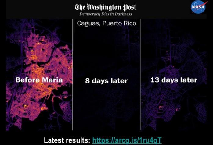
11 Monitoring Critical Infrastructure Radar Optical Thermal Lifelines Transport Power Water Resources Supply Chains High resolution nighttime maps combined data from six satellites (Suomi-NPP, Landsat-8, Sentinel 2A & 2B, TerraSAR- X/TanDEM-X) to enable first-ever daily monitoring of affected areas at neighborhood scales (< 30 meters) 11


12 Monitoring Impact Harvey Irma GPM and the IMERG product provide rainfall estimates for islands lacking radar, or to help gap fill radar coverage lost in the storm (NWS San Juan, PR) 12 12
 30 August 2017 MSFC/ASF")

 extremely useful during Harvey for model")

13 Mapping Exposure, Flood Extent and Damage Texas Flood Proxy Map (Hurricane Harvey) 30 August 2017 MSFC/ASF Satellite Radar Mapping Flooding Flooding JPL/ARIA JPL/ARIA UAVSAR/JPL Flights in Houston Puerto Rico Damage Proxy Map (Hurricane Maria) We found your (flood maps) extremely useful during Harvey for model validation and identifying locations of flooding that we could not predict with modeled riverine depth grids. -FEMA 13

14 Radar Mapping Flood Impact What this provided: Helped provide a more complete picture than with satellite imagery alone Information on flood cresting across four major river basins as waters drained to the Gulf NASA deployed UAVSAR to fill information gaps and generated single channel quick-look products during flight and post-flight for officials. I think we may have seen the future of flood response - Gordon Wells, Texas Center for Space Research and Special Advisor to the TX Natural Disasters Working Group. 14

 Use of")


15 Hydro-Meteorology Timeline Hurricane Harvey (Aug-Sept 2017) Charter/RadarSat-2 Flood Map NASA, NOAA, ESA, International Space Station, and Charter data used collaboratively to map flooding from SAR/optical Sentinel 1A ARIA Flood Proxy Map (Hurricane Harvey) Use of NASA Black Marble HD product to explore power outages during post-harvey flooding 30 August 2017 Forecasts for Harvey identify impacts to U.S. mainland, NASA team activates for coordination calls, product generation, and end-user engagement Flooding Modeling disaster impacts, insured losses, in Houston metro Flooding Sentinel 1B False Color RGB showing flooding in Texas along the Colorado and Brazos Rivers. Nighttime Lights: Tracking Power Outages Houston, TX Post-Harvey ALOS-2 Flood Proxy Map 0 Day 1 August 23 NASA Response Tier Daily calls begin to coordinate NASA team in generation of products, engagement of funded PIs, and coordination with federal end user partners including FEMA, USGS, National Guard, and others. Houston, TX - September 1, [Numerous Flood Maps from NASA Teams Day 4 Day 11 Day 9 Day 6 Day 7 Day 10 Day 11 UAVSAR Flights August 27 August 27 August 28 September 4 August 30 August 31 September 1 GPM maps the record-setting rainfall in SE Texas from Harvey NASA s GPM helps track Harvey with data provided to NOAA/NWS and NHC NASA team collaborations provide over a dozen detailed flood maps from SAR used by FEMA s geospatial team 1 increased flooding from 9/1-2 9/1/17 9/2/17 0 Day 19 September 9 NASA provides daily flights of UAVSAR from September 1-4 to rapidly map evolving flood impacts


16 Geospatial Enablement 16


17 NASA s DISASTERS Program Perspectives on Earth as a Dynamic System Accessible Scalable Flexible Reducing Risk Building Resilience Poster: NASA Applied Sciences Disasters Program Flood Research, Response and Resiliency Efforts 17
NASA Disasters Program Approach/Principles
 Strengthening Disaster Risk Reduction and Reslience the Contributions of Earth Observations Dr. David Green Disasters Program Science Mission Directorate Earth Science Division UNITED NATIONS ESCAP Economic
NASA Disasters Program: Response, Recovery, Mitigation and Resilience
 NASA Disasters Program: Response, Recovery, Mitigation and Resilience Dalia Kirschbaum, PhD NASA Disaster Response Coordinator Dalia.kirschbaum@nasa.gov https://disasters.nasa.gov NASA s Earth Observation
Effective Utilization of Synthetic Aperture Radar (SAR) Imagery in Rapid Damage Assessment
 Imagery in Rapid Damage Assessment") Effective Utilization of Synthetic Aperture Radar (SAR) Imagery in Rapid Damage Assessment Case Study Pakistan Floods SUPARCO M. Maisam Raza, Ahmad H. Rabbani SEQUENCE Flood Monitoring using Satellite
Effective Utilization of Synthetic Aperture Radar (SAR) Imagery in Rapid Damage Assessment Case Study Pakistan Floods SUPARCO M. Maisam Raza, Ahmad H. Rabbani SEQUENCE Flood Monitoring using Satellite
Lessons Learned from Hurricane Harvey and Irma
 EOL Visit to NSF 3 March 2016 Lessons Learned from Hurricane Harvey and Irma Wen-Chau Lee National Center for Atmospheric Research 23 November 2017 Outline: Meteorological elements of the active 2017 Atlantic
NASA Flood Monitoring and Mapping Tools
 National Aeronautics and Space Administration ARSET Applied Remote Sensing Training http://arset.gsfc.nasa.gov @NASAARSET NASA Flood Monitoring and Mapping Tools www.nasa.gov Outline Overview of Flood
Current and Upcoming NASA Hurricane Measurement Missions National Hurricane Conference
 NASA Science Mission Directorate Earth Science Division Applied Sciences Program Current and Upcoming NASA Hurricane Measurement Missions National Hurricane Conference April 18, 2017 Formulation Implementation
Amina Rangoonwala and Elijah Ramsey III Wetland and Aquatic Research Center. U.S. Geological Survey. Lafayette, LA
 First I will show examples of radar mapping of hurricane surge extent and duration and optical mapping of the resultant marsh dieback along the Louisiana coast Next we extend these works to hurricane Sandy
Earth observations guided efforts to aid communities swamped by historic flooding 9 August 2017
 Earth observations guided efforts to aid communities swamped by historic flooding 9 August 2017 Credit: NASA Flooding killed more than 125 people in the U.S. in 2016. When disasters threaten the lives
Incorporation of SMOS Soil Moisture Data on Gridded Flash Flood Guidance for Arkansas Red River Basin
 Incorporation of SMOS Soil Moisture Data on Gridded Flash Flood Guidance for Arkansas Red River Basin Department of Civil and Environmental Engineering, The City College of New York, NOAA CREST Dugwon
JPSS GEONETCAST REQUIREMENTS DISCUSSION
 Joint Polar Satellite System (JPSS) JPSS GEONETCAST REQUIREMENTS DISCUSSION Mitch Goldberg Program Scientist Joint Polar Satellite System National Environmental Satellite, Data, and Information Service
13.2 USING VIRTUAL GLOBES TO IMPROVE SITUATIONAL AWARENESS IN THE NATIONAL WEATHER SERVICE
 13.2 USING VIRTUAL GLOBES TO IMPROVE SITUATIONAL AWARENESS IN THE NATIONAL WEATHER SERVICE Andy Foster* National Weather Service Springfield, Missouri* Keith Stellman National Weather Service Shreveport,
New NASA Ocean Observations and Coastal Applications
 New NASA Ocean Observations and Coastal Applications Duane Armstrong Chief, Applied Science & Technology Project Office August 20, 2014 1 Outline NASA s new Earth Science Ocean Science Missions for 2014
Hurricane Harvey Flood Emergency Response
 Hot Science - Cool Talk # 114 Hurricane Harvey Flood Emergency Response Dr. David Maidment September 14, 2018 Produced by and for Hot Science - Cool Talks by the Environmental Science Institute. We request
Development of Tropical Storm Falcon (Meari) over the Philippines
 over the Philippines") Development of Tropical Storm Falcon (Meari) over the Philippines June 20-27, 2011 At the end of June, 2011, the Philippines were struck again by Tropical storm Falcon (Meari). After gaining strength over
Development of Tropical Storm Falcon (Meari) over the Philippines June 20-27, 2011 At the end of June, 2011, the Philippines were struck again by Tropical storm Falcon (Meari). After gaining strength over
Use of Geospatial data for disaster managements
 Use of Geospatial data for disaster managements Source: http://alertsystemsgroup.com Instructor : Professor Dr. Yuji Murayama Teaching Assistant : Manjula Ranagalage What is GIS? A powerful set of tools
Welcome Jeff Orrock Warning Coordination Meteorologist National Weather Service Raleigh
 Welcome Jeff Orrock Warning Coordination Meteorologist National Weather Service Raleigh Jeff.orrock@noaa.gov Sources: Operational Significant Event Imagery and the Environmental Applications Team (EAT)
Daily Operations Briefing. Wednesday, November 8, :30 a.m. EST
 Daily Operations Briefing Wednesday, November 8, 2017 8:30 a.m. EST Significant Activity Nov 7-8 Significant Events: Tropical Cyclones Harvey, Irma, and Maria Tropical Activity: Atlantic Tropical Storm
Daily Operations Briefing. Thursday, September 21, :30 a.m. EDT
 Daily Operations Briefing Thursday, September 21, 2017 8:30 a.m. EDT Significant Activity Sep 20-21 Significant Events: Response for Hurricane Maria Tropical Activity: Atlantic Tropical Storm Jose; Hurricane
CLIMATE CHANGE ADAPTATION BY MEANS OF PUBLIC PRIVATE PARTNERSHIP TO ESTABLISH EARLY WARNING SYSTEM
 CLIMATE CHANGE ADAPTATION BY MEANS OF PUBLIC PRIVATE PARTNERSHIP TO ESTABLISH EARLY WARNING SYSTEM By: Dr Mamadou Lamine BAH, National Director Direction Nationale de la Meteorologie (DNM), Guinea President,
Interagency Remote Sensing Coordination Call Conference Bridge: , Passcode:
 Interagency Remote Sensing Coordination Call Conference Bridge: 800-320-4330, Passcode: 247327 Tropical Activity Atlantic and Pacific Tuesday, September 12, 2018 Remote Sensing - NRCC and HQ: Preparing
CAN THO URBAN DEVELOPMENT AND RESILIENCE PROJECT
 CAN THO URBAN DEVELOPMENT AND RESILIENCE PROJECT 1 Phnom Penh Can Tho City HCM City EAST SEA 2 1 3 Highest Water Level WATER LEVEL RAISE IN CAN THO DURING LAST 40 YEARS 4 2 Land subsidence a threat that
A multi-tiered ADCIRC-based storm surge and wave prediction system
 A multi-tiered ADCIRC-based storm surge and wave prediction system Brian Blanton, Renaissance Computing Institute, UNC-Chapel Hill Rick Luettich, Institute of Marine Sciences, UNC-Chapel Hill, co-pi Jason
Daily Operations Briefing. Thursday, November 9, :30 a.m. EST
 Daily Operations Briefing Thursday, November 9, 2017 8:30 a.m. EST Significant Activity Nov 8-9 Significant Events: Tropical Cyclones Harvey, Irma, and Maria Tropical Activity: Atlantic Tropical Storm
Daily Operations Briefing. Tuesday, October 24, :30 a.m. EDT
 Daily Operations Briefing Tuesday, October 24, 2017 8:30 a.m. EDT Significant Activity Oct 23-24 Significant Events: Response and recovery Tropical Cyclones Harvey, Irma, Maria Tropical Activity: Atlantic
Daily Operations Briefing. Sunday, October 22, :30 a.m. EDT
 Daily Operations Briefing Sunday, October 22, 2017 8:30 a.m. EDT Significant Activity Oct 21-22 Significant Events: Response and recovery Harvey, Irma, Maria; CA Wildfires Tropical Activity: Atlantic No
Florida Flood Risks. Heavy Rainfall. Groundwater. Tidal Flooding. Storm Surge. King Tides. Runoff/Riverine
 Florida Flood Risks Heavy Rainfall Storm Surge Groundwater Tidal Flooding Runoff/Riverine King Tides Sawgrass Mills Mall Sunrise, Florida 15 of rain in 3 days, with most in 24 hours. Mall closed for 3
Daily Operations Briefing. Friday, November 10, :30 a.m. EST
 Daily Operations Briefing Friday, November 10, 2017 8:30 a.m. EST Significant Activity Nov 9-10 Significant Events: None Tropical Activity: Atlantic No tropical cyclones expected next 48 hours Eastern
Daily Operations Briefing. Tuesday, November 7, :30 a.m. EST
 Daily Operations Briefing Tuesday, November 7, 2017 8:30 a.m. EST Significant Activity Nov 6-7 Significant Events: Tropical Cyclones Harvey, Irma, and Maria Tropical Activity: Atlantic Tropical Storm Rina
Interagency Remote Sensing Coordination Call Conference Bridge: , Passcode:
 Interagency Remote Sensing Coordination Call Conference Bridge: 800-320-4330, Passcode: 132811 Tropical Activity Atlantic and Pacific Tuesday, September 12, 2018 FEMA RS Updates: 1. The International Charter
Current Situation Report Hurricane Irma - Atlantic Ocean - Current Situation Report - 08 Sep 17 (Update 03)
") Current Situation Report Hurricane Irma - Atlantic Ocean - Current Situation Report - 08 Sep 17 (Update 03) Date As Of: 09/08/2017 21:39:11 Sitrep Update #: 03 Incident Start Time: 09/06/2017 12:09:38
Current Situation Report Hurricane Irma - Atlantic Ocean - Current Situation Report - 08 Sep 17 (Update 03) Date As Of: 09/08/2017 21:39:11 Sitrep Update #: 03 Incident Start Time: 09/06/2017 12:09:38
NASA Jet Propulsion Laboratory Data Products
 NASA Jet Propulsion Laboratory Data Products 17 April 2014 Emergency Response Spatial Tools Technical Interchange Maggi Glasscoe Margaret.T.Glasscoe@jpl.nasa.gov Sang-Ho Yun Sang-Ho.Yun@jpl.nasa.gov www.nasa.gov
URBAS Prediction and management of flash floods in urban areas
 URBAS Prediction and management of flash floods in urban areas 1 Thomas Einfalt, Klaus Friedeheim, Andreas Wagner Project funded by the Federal Ministry of Education and Research BMBF (Germany) as a part
EXTRACTION OF FLOODED AREAS DUE THE 2015 KANTO-TOHOKU HEAVY RAINFALL IN JAPAN USING PALSAR-2 IMAGES
 EXTRACTION OF FLOODED AREAS DUE THE 2015 KANTO-TOHOKU HEAVY RAINFALL IN JAPAN USING PALSAR-2 IMAGES F. Yamazaki a, *, W. Liu a a Chiba University, Graduate School of Engineering, Chiba 263-8522, Japan
Space-based Weather and Climate Extremes Monitoring (SWCEM) Toshiyuki Kurino WMO Space Programme IPET-SUP-3, 2-4 May 2017
 Toshiyuki Kurino WMO Space Programme IPET-SUP-3, 2-4 May 2017") Space-based Weather and Climate Extremes Monitoring (SWCEM) Toshiyuki Kurino WMO Space Programme IPET-SUP-3, 2-4 May 2017 based on outcome from Workshop on Operational SWCEM 15-17 February 2017, Geneva
Space-based Weather and Climate Extremes Monitoring (SWCEM) Toshiyuki Kurino WMO Space Programme IPET-SUP-3, 2-4 May 2017 based on outcome from Workshop on Operational SWCEM 15-17 February 2017, Geneva
NOAA s OCM: Services, tools and collaboration opportunities & Puerto Rico s NE Marine Corridor as a case study
 NOAA s OCM: Services, tools and collaboration opportunities & Puerto Rico s NE Marine Corridor as a case study Dr. Antares Ramos Álvarez NOAA s Office of Coastal Management September 15 th, 2016 Conservation
Daily Operations Briefing. Saturday, September 30, :30 a.m. EDT
 Daily Operations Briefing Saturday, September 30, 2017 8:30 a.m. EDT Significant Activity Sep 29-30 Significant Events: Response for Hurricane Maria Tropical Activity: Atlantic Tropical Storm Maria; Post-Tropical
Daily Operations Briefing. Sunday, October 29, :30 a.m. EDT
 Daily Operations Briefing Sunday, October 29, 2017 8:30 a.m. EDT Significant Activity Oct 28-29 Significant Events: Response and Recovery Tropical Cyclones Harvey, Irma, and Maria Tropical Activity: Atlantic
Daily Operations Briefing. Monday, October 30, :30 a.m. EDT
 Daily Operations Briefing Monday, October 30, 2017 8:30 a.m. EDT Significant Activity Oct 28-30 Significant Events: Response and Recovery Tropical Cyclones Harvey, Irma, and Maria Severe Weather Northeast
Improving global coastal inundation forecasting WMO Panel, UR2014, London, 2 July 2014
 Improving global coastal inundation forecasting WMO Panel, UR2014, London, 2 July 2014 Cyclone Sidr, November 2007 Hurricane Katrina, 2005 Prof. Kevin Horsburgh Head of marine physics, UK National Oceanography
GEONETCast Future Plans at CIMH
 GEONETCast Future Plans at CIMH Operations, Training, Climate Monitoring and Disaster Preparedness WORLD METEOROLOGICAL ORGANIZATION COORDINATION GROUP ON SATELLITE DATA REQUIREMENTS FOR REGION III AND
Daily Operations Briefing. Thursday, October 26, :30 a.m. EDT
 Daily Operations Briefing Thursday, October 26, 2017 8:30 a.m. EDT Significant Activity Oct 25-26 Significant Events: Response and recovery Tropical Cyclones Harvey, Irma and Maria Tropical Activity: Atlantic
Tropical Update. 5 AM EDT Tuesday, September 12, 2017 Post-Tropical Cyclone Irma, Hurricane Jose, & Tropical Wave (10%)
") Tropical Update 5 AM EDT Tuesday, September 12, 2017 Post-Tropical Cyclone Irma, Hurricane Jose, & Tropical Wave (10%) This update is intended for government and emergency response officials, and is provided
Tropical Update 5 AM EDT Tuesday, September 12, 2017 Post-Tropical Cyclone Irma, Hurricane Jose, & Tropical Wave (10%) This update is intended for government and emergency response officials, and is provided
Flash Flood Guidance System On-going Enhancements
 Flash Flood Guidance System On-going Enhancements Hydrologic Research Center, USA Technical Developer SAOFFG Steering Committee Meeting 1 10-12 July 2017 Jakarta, INDONESIA Theresa M. Modrick Hansen, PhD
Global Precipitation Measurement (GPM) for Science and Society
 for Science and Society") Global Precipitation Measurement (GPM) for Science and Society Gail Skofronick-Jackson GPM Project Scientist NASA Goddard Space Flight Center Radar Observation of Rain from Space Tokyo, Japan 29 November
Global Precipitation Measurement (GPM) for Science and Society Gail Skofronick-Jackson GPM Project Scientist NASA Goddard Space Flight Center Radar Observation of Rain from Space Tokyo, Japan 29 November
Daily Operations Briefing. Monday, October 9, :30 a.m. EDT
 Daily Operations Briefing Monday, October 9, 2017 8:30 a.m. EDT Significant Activity Oct 8-9 Significant Events: Response for Hurricane Maria Tropical Activity: Atlantic Tropical Depression Seventeen Eastern
JCOMM-CHy Coastal Inundation Forecasting Demonstration Project (CIFDP)
") WMO World Meteorological Organization Working together in weather, climate and water JCOMM-CHy Coastal Inundation Forecasting Demonstration Project (CIFDP) Coastal Flooding & Vulnerable Populations Coastal
WMO World Meteorological Organization Working together in weather, climate and water JCOMM-CHy Coastal Inundation Forecasting Demonstration Project (CIFDP) Coastal Flooding & Vulnerable Populations Coastal
Japanese Programs on Space and Water Applications
 Japanese Programs on Space and Water Applications Tamotsu IGARASHI Remote Sensing Technology Center of Japan June 2006 COPUOS 2006 Vienna International Centre Water-related hazards/disasters may occur
Pacific Catastrophe Risk Assessment And Financing Initiative
 Pacific Catastrophe Risk Assessment And Financing Initiative PALAU September is expected to incur, on average,.7 million USD per year in losses due to earthquakes and tropical cyclones. In the next 5 years,
After 2017 Is the Future Predictable?
 After 2017 Is the Future Predictable? Presented by: Evan Thompson Director, Meteorological Service, Jamaica At Caribbean Insurance Conference, Montego Bay, Jamaica June 4, 2018 What s Happening with the
America must act to protect its power grid
 Page 1 of 5 Opinion Utilities America must act to protect its power grid JAMES WOOLSEY When Hurricane Maria struck the US territory of Puerto Rico, the entire island lost power AFP James Woolsey OCTOBER
Country Report - Singapore
 Country Report - Singapore The 5th Meeting of the Coordinating Group Vladivostok city, Russky Island, Russia Far Eastern Federal University of the RA II WIGOS Satellite Project 21 October 2017 Outline
Daily Operations Briefing. Sunday, September 24, :30 a.m. EDT
 Daily Operations Briefing Sunday, September 24, 2017 8:30 a.m. EDT Significant Activity Sep 23-24 Significant Events: Response for Hurricane Maria Tropical Activity: Atlantic Hurricane Maria (CAT 2); Hurricane
Weather Satellite Data Applications for Monitoring and Warning Hazard at BMKG
 The 5th Meeting of the Coordinating Group of the RA II WIGOS Satellite Project 21 October 2017, Vladivostok city, Russky Island, Russia Far Eastern Federal University Weather Satellite Data Applications
How does NASA study hurricanes? 17 August 2015, by Max Gleber
 How does NASA study hurricanes? 17 August 2015, by Max Gleber Hurricanes are the most powerful weather event on Earth. NASA's expertise in space and scientific exploration contributes to essential services
Daily Operations Briefing. Wednesday, October 18, :30 a.m. EDT
 Daily Operations Briefing Wednesday, October 18, 2017 8:30 a.m. EDT Significant Activity Oct 17-18 Significant Events: Response and recovery Harvey, Irma, Maria; CA Wildfires Tropical Activity: Atlantic
NOAA Storm Surge Modeling Gaps and Priorities
 NOAA Storm Surge Modeling Gaps and Priorities HFIP Meeting November 9 th, 2017 Laura Paulik Alaka NHC Storm Surge Unit Introduction to Probabilistic Storm Surge P-Surge is based on an ensemble of Sea,
City of Madison Flooding Event AUGUST 20 TH, 2018-PRESENT
 City of Madison Flooding Event AUGUST 20 TH, 2018-PRESENT Presentation Overview Review of Flash Flooding and Flooding from High Lake Levels (August 20 th -Present) Lake Level Information Damages FEMA How
Pacific Catastrophe Risk Assessment And Financing Initiative
 Pacific Catastrophe Risk Assessment And Financing Initiative VANUATU September 211 Country Risk Profile: VANUATU is expected to incur, on average, 48 million USD per year in losses due to earthquakes and
Initiative. Country Risk Profile: papua new guinea. Better Risk Information for Smarter Investments PAPUA NEW GUINEA.
 Pacific Catastrophe Risk Assessment And Financing Initiative PAPUA NEW GUINEA September 211 Country Risk Profile: papua new is expected to incur, on average, 85 million USD per year in losses due to earthquakes
Texas Statewide Mesonet Network (TexMesonet) Dr. Kantave Greene 11/15/17
 Dr. Kantave Greene 11/15/17") Texas Statewide Mesonet Network (TexMesonet) Dr. Kantave Greene 11/15/17 1 Observe weather features Why Mesonets? Thunderstorms Squall lines Dry-lines Sea breezes Improve weather & flood forecasts Drought
Texas Statewide Mesonet Network (TexMesonet) Dr. Kantave Greene 11/15/17 1 Observe weather features Why Mesonets? Thunderstorms Squall lines Dry-lines Sea breezes Improve weather & flood forecasts Drought
National Flood Interoperability Experiment
 National Flood Interoperability Experiment David R. Maidment, University of Texas at Austin Catchment-based Hydrological Data Assimilation (CAHMDA) VI Conference 8 September 2014 Located on Tuscaloosa
Hazard Impact Modelling for Storms Workshop
 The UK s trusted voice for coordinated natural hazards advice Hazard Impact Modelling for Storms Workshop Ken Mylne, Becky Hemingway, Ervin Zsoter ECMWF UEF 2017, 15 th June 2017 The UK s trusted voice
United States Multi-Hazard Early Warning System
 United States Multi-Hazard Early Warning System Saving Lives Through Partnership Lynn Maximuk National Weather Service Director, Central Region Kansas City, Missouri America s s Weather Enterprise: Protecting
What hit us Notes on the Physical Geography of Hurricanes Irma and Maria
 What hit us Notes on the Physical Geography of Hurricanes Irma and Maria Carlos E Ramos-Scharron Department of Geography & the Environment and LLILAS UT-Austin Objectives Central theme is MAGNITUDE How
1.2 DEVELOPMENT OF THE NWS PROBABILISTIC EXTRA-TROPICAL STORM SURGE MODEL AND POST PROCESSING METHODOLOGY
 1.2 DEVELOPMENT OF THE NWS PROBABILISTIC EXTRA-TROPICAL STORM SURGE MODEL AND POST PROCESSING METHODOLOGY Huiqing Liu 1 and Arthur Taylor 2* 1. Ace Info Solutions, Reston, VA 2. NOAA / NWS / Science and
Uses of free satellite imagery for Disaster Risk Reduction (DRR)
") Centre of Applied Geoscience, Disaster Risk Reduction Research Group, School of Earth and Environmental Science, University of Portsmouth, UK Uses of free satellite imagery for Disaster Risk Reduction
Centre of Applied Geoscience, Disaster Risk Reduction Research Group, School of Earth and Environmental Science, University of Portsmouth, UK Uses of free satellite imagery for Disaster Risk Reduction
New Concept of Regional Cooperation in Asia for Water Disaster Management Applying Satellite Precipitation Measurement
 New Concept of Regional Cooperation in Asia for Water Disaster Management Applying Satellite Precipitation Measurement Yusuke Muraki Japan Aerospace Exploration Agency (JAXA) Mission Planning Department
GC Briefing. Weather Sentinel Hurricane Florence. Status at 5 PM EDT (21 UTC) Today (NHC) Discussion. September 13, 2018
 Today (NHC) Discussion. September 13, 2018") GC Briefing September 13, 2018 Weather Sentinel Hurricane Florence Tropical storm conditions have been reported for areas of North Carolina and will continue to spread inland to the west and south. Hurricane
GC Briefing September 13, 2018 Weather Sentinel Hurricane Florence Tropical storm conditions have been reported for areas of North Carolina and will continue to spread inland to the west and south. Hurricane
Real-Time Flood Forecasting Modeling in Nashville, TN utilizing HEC-RTS
 Real-Time Flood Forecasting Modeling in Nashville, TN utilizing HEC-RTS Brantley Thames, P.E. Hydraulic Engineer, Water Resources Section Nashville District, USACE August 24, 2017 US Army Corps of Engineers
Storm Surge Analysis Update Meeting Cross City, Florida June 17, 2014
 Big Bend Coastal Storm Surge Study Storm Surge Analysis Update Meeting Cross City, Florida June 17, 2014 Introductions Risk MAP Project Team FEMA Region IV Florida Division of Emergency Management (FDEM)
Mapping Coastal Change Using LiDAR and Multispectral Imagery
 Mapping Coastal Change Using LiDAR and Multispectral Imagery Contributor: Patrick Collins, Technical Solutions Engineer Presented by TABLE OF CONTENTS Introduction... 1 Coastal Change... 1 Mapping Coastal
CGMS-45-WMO-WP-05 Monitoring Extreme Weather and Climate from Space. World Meteorological Organization (WMO) Space Programme
 Space Programme") CGMS-45-WMO-WP-05 Monitoring Extreme Weather and Climate from Space World Meteorological Organization (WMO) Space Programme Introduction UNOSAT Report Satellite Detected Waters over Xieng Ngneun District,
CGMS-45-WMO-WP-05 Monitoring Extreme Weather and Climate from Space World Meteorological Organization (WMO) Space Programme Introduction UNOSAT Report Satellite Detected Waters over Xieng Ngneun District,
2006 & 2007 Pre-Hurricane Scenario Analyses
 2006 & 2007 Pre-Hurricane Scenario Analyses Executive Summary May 2007 Page 1 OF X FOR OFFICIAL USE ONLY 4 Public Availability to be Determined Under 5 U.S.C. 552 NOTE: Limited Distribution. Release of
DRRM in the Philippines: DRRM Projects, Geoportals and Socio-Economic Integration
 Regional workshop on Geo-referenced information system for improving disaster risk preparedness and management in Asia and the Pacific 26-27 June 2014, UNCC, Bangkok, Thailand DRRM in the Philippines:
Roles of NGII in successful disaster management
 The Second UN-GGIM-AP Plenary Meeting Roles of NGII in successful disaster management Republic of Korea Teheran Iran 28 October 2013 Sanghoon Lee, Ph.D. NGII Outline Type of Disasters Occur in Korea Practical
Summary of Available Datasets that are Relevant to Flood Risk Characterization
 Inter-Agency Characterization Workshop February 25-27, 2014 USACE Institute for Water Resources, Alexandria, VA, IWR Classroom Summary of Available Datasets that are Relevant to Characterization National
Disaster Risk Management in India. Kamal Kishore New Delhi, 27 October 2016
 Disaster Risk Management in India Kamal Kishore New Delhi, 27 October 2016 Hazard, Exposure and Vulnerability Disaster Prevention Mitigation Hurricane Matthew: Cuba & Haiti Emergency Response Coordination
National Situation Report As of 3:00 a.m. EDT, Thursday, September 21, 2017 Table of Contents Current Operations Monitoring Recovery
 25k Overview National Situation Report As of 3:00 a.m. EDT, Thursday, September 21, 2017 Table of Contents Current Operations Monitoring Recovery FEMA Headquarters Status FEMA Region Status NRCC Level
Storm Surge/Coastal Inundation State of the Union. Jamie Rhome Storm Surge Team Lead NOAA/National Hurricane Center
 Storm Surge/Coastal Inundation State of the Union Jamie Rhome Storm Surge Team Lead NOAA/National Hurricane Center 2 Tampa: Cat 5 Scenario 3 4 The Stakes are High Combination of SLR and increasing coastal
Appendix C Fluvial Flood Hazards
 Appendix C Fluvial Flood Hazards Sea Level Rise Vulnerability Assessment and Adaptation Project March 2019 Contents Contents... i Figures... i Tables... i Definitions, Acronyms, & Abbreviations... ii
Coastal Ocean Applications Demonstrations of ALOS PALSAR Imagery for NOAA CoastWatch
 Coastal Ocean Applications Demonstrations of ALOS PALSAR Imagery for NOAA CoastWatch William Pichel Center for Satellite Applications and Research Frank Monaldo The Johns Hopkins University Applied Physics
Interagency Remote Sensing Coordination Call Conference Bridge: , Passcode:
 Interagency Remote Sensing Coordination Call Conference Bridge: 800-320-4330, Passcode: 247327 Tropical Activity Atlantic and Pacific Saturday, September 15, 2018 Remote Sensing - NRCC and HQ: Preparing
Estimating the Spatial Distribution of Power Outages during Hurricanes for Risk Management
 Estimating the Spatial Distribution of Power Outages during Hurricanes for Risk Management Marco Palmeri Independent Consultant Master s Candidate, San Francisco State University Dept. of Geography September
Pacific Catastrophe Risk Assessment And Financing Initiative
 Pacific Catastrophe Risk Assessment And Financing Initiative TUVALU is expected to incur, on average,. million USD per year in losses due to earthquakes and tropical cyclones. In the next 5 years, has
A New National Flood Inundation Mapping Science Initiative
 A New National Flood Inundation Mapping Science Initiative William Guertal, PhD. Director, USGS Indiana and Kentucky Water Science Centers U.S. Department of the Interior U.S. Geological Survey Courtesy
Impact of the 2008 tropical cyclone season on the Baja California Peninsula
 Impact of the 2008 tropical cyclone season on the Baja California Peninsula Centro de Investigación Científica y de Educación Superior de Ensenada (CICESE) Luis M. Farfán Julio August 24, 1830UTC Lowell
From Climate Science to Climate Services
 Making sense of complexity in an interdependent world: February 2013 From Climate Science to Climate Services Julia Slingo, Met Office Chief Scientist Climate Change: Taking the planet into uncharted territory?
3Chapter Three: Rescue and Response
 17 16 Report Science Title and the Storms: the USGS Response to the Hurricanes of 2005 3Chapter Three: Rescue and Response This chapter documents the U.S. Geological Survey s (USGS) humanitarian rescue
Rainfall-River Forecasting: Overview of NOAA s Role, Responsibilities, and Services
 Dr. Thomas Graziano Chief Hydrologic Services Division NWS Headquarters Steve Buan Service Coordination Hydrologist NWS North Central River Forecast Center Rainfall-River Forecasting: Overview of NOAA
WHAT HAPPENS WHEN A TORNADO STRIKES THE COMMUNITY? Carroll County Sheriff s Office Emergency Management
 WHAT HAPPENS WHEN A TORNADO STRIKES THE COMMUNITY? Carroll County Sheriff s Office Emergency Management WHAT IS EMERGENCY MANAGEMENT? Carroll County Sheriff s Office Emergency Management Agency is responsible
AHEAD OF THE STORM: Extreme Weather Resilience in the City of Toronto
 AHEAD OF THE STORM: Extreme Weather Resilience in the City of Toronto David MacLeod Toronto Environment and Energy Office Environmental Applied Science and Management Symposium 2013 March 21, 2013 Ahead
Crisis Management and Natural Disasters Overview of JRC operational or pre-operational activities A. Annunziato, D. Al-Khudhairy
 Papagayo, Costarica 3-4 November 2009 Security Science and The Americas 1 Joint Research Centre (JRC) Crisis Management and Natural Disasters Overview of JRC operational or pre-operational activities A.
Hurricane Harvey: Texas Coastal Erosion Hot Spot Analysis
 Hurricane Harvey: Texas Coastal Erosion Hot Spot Analysis Texas ASBPA Symposium April 24, 2018 Alan Johnson, FEMA Chris Levitz, Compass Agenda Introduction Hurricane Harvey Erosion Hot Spot Analysis Purpose
FLORENCE AFTERMATH PAYNE INSTITUTE COMMENTARY SERIES: VIEWPOINT. Can the Power Outages Be Seen from Space?
 PAYNE INSTITUTE COMMENTARY SERIES: VIEWPOINT FLORENCE AFTERMATH Can the Power Outages Be Seen from Space? By Chris Elvidge, Kimberly Baugh, and Morgan Bazilian September, 2018 TRACKING ENERGY DISRUPTIONS
Moving Freshwater to the Ocean: Hydrology-Ocean Model Coupling
 Moving Freshwater to the Ocean: Hydrology-Ocean Model Coupling Cheryl Ann Blain 1, Tim Campbell 1, Song Yang 2, Aubrey Dugger 3, Paul Martin 1, Tommy Jenson 1 Naval Research Laboratory 1 Oceanography Division,
Tropical Cyclone Isaac (AL092012)
") Tropical Cyclone Isaac (AL092012) Event Briefing, Central Caribbean Impacts Caribbean Risk Managers Ltd Facility Supervisor 27 August 2012 Facility Supervisor: Caribbean Risk Managers Ltd Email: ccrif@ccrif.org
Tropical Cyclone Isaac (AL092012) Event Briefing, Central Caribbean Impacts Caribbean Risk Managers Ltd Facility Supervisor 27 August 2012 Facility Supervisor: Caribbean Risk Managers Ltd Email: ccrif@ccrif.org
An Application of Hydrometeorological Information
 An Application of Hydrometeorological Information Weather-proof Café: Hydro-meteorological information in managing weather risks 17 19 November 2012 National Taiwan University, Chinese Taipei Nikos Viktor
Expansion of NCEP Operational Hurricane Weather Research and Forecast (HWRF) Model Forecast Guidance to all Global Tropical Cyclones
 Model Forecast Guidance to all Global Tropical Cyclones") Expansion of NCEP Operational Hurricane Weather Research and Forecast (HWRF) Model Forecast Guidance to all Global Tropical Cyclones Dr. Vijay Tallapragada, Hurricane Team Leader & HFIP Development Manager,
Expansion of NCEP Operational Hurricane Weather Research and Forecast (HWRF) Model Forecast Guidance to all Global Tropical Cyclones Dr. Vijay Tallapragada, Hurricane Team Leader & HFIP Development Manager,
Ensuring the Building of Community Resiliency through Effective Partnership December 4, 2017 Melia Nassau Beach Valentino A. Hanna
 Ensuring the Building of Community Resiliency through Effective Partnership December 4, 2017 Melia Nassau Beach Valentino A. Hanna Sol Caribbean Presence What Occurred Mega Storms 2017 Cat 5 Hurricane
RESILIENCE: THE NEW REALITY JEFFREY D. KNUEPPEL DEPUTY GENERAL MANAGER MARCH 17, 2015
 RESILIENCE: THE NEW REALITY JEFFREY D. KNUEPPEL DEPUTY GENERAL MANAGER MARCH 17, 2015 EXTREME WEATHER = EXTREME COST EIGHT SEPARATE BILLION DOLLAR EXTREME WEATHER EVENTS ACROSS U.S. IN 2014 JANUARY 2014