Coastal Ocean Applications Demonstrations of ALOS PALSAR Imagery for NOAA CoastWatch
|
|
|
- Matthew Merritt
- 5 years ago
- Views:
Transcription
1 Coastal Ocean Applications Demonstrations of ALOS PALSAR Imagery for NOAA CoastWatch William Pichel Center for Satellite Applications and Research Frank Monaldo The Johns Hopkins University Applied Physics Laboratory Christopher Wackerman General Dynamics Advanced Information Systems Christopher Jackson Global Ocean Associates Xiaofeng Li IMSG at NOAA/NESDIS Pablo Clemente-Colón - National Ice Center Oscar Garcia-Pineda Florida State University ALOS PI Meeting Kona, 11/9/2009
2 Coastal Ocean Applications Demonstrations of ALOS PALSAR Imagery for NOAA CoastWatch Research Goals CoastWatch Outline Alaska SAR Demonstration (AKDEMO) Hurricane Hazard Response
3 ALOS Project Research Goals (1) Develop quantitative and qualitative coastal and hydrologic applications of ALOS L-band SAR imagery for NOAA s CoastWatch Program. Ocean surface winds Vessel positions Oil spill mapping Ocean Feature Detection River Ice Monitoring (2) To demonstrate these applications by conducting application demonstrations in near-real-time, if possible. Alaska SAR Demonstration Hurricane Hazard Response
4 CoastWatch CoastWatch: A national program within NOAA to produce and distribute satellite-derived ocean products via regional NOAA laboratories that provide local user support to a diverse marine user community (Atlantic, Pacific, Gulf of Mexico/Caribbean, Great Lakes, Hawaii, and Alaska). SAR Products will eventually be distributed by CoastWatch along with SST, Ocean Color, ocean surface winds and other satellite-derived ocean products.
 AKDEMO APPLICATIONS")


5 Alaska SAR Demonstration (AKDEMO) AKDEMO APPLICATIONS Vessel Detection Ice Masks River Ice Spring Breakup CSA 1998 Mesoscale Wind Features Quantitative Coastal Winds AKDEMO: A pre-operational demonstration of near real-time coastal and marine products for Alaskan waters, derived from satellite synthetic aperture radar (SAR) data


6 SAR Coastal Winds using ALOS PALSAR Aleutian Islands, Alaska
7 L-Band PALSAR Wind Performance No Correction With σ o Correction PALSAR versus NOGAPS Model wind speed. Error bars are 90% confidence limits. Monaldo and Thompson, IGARSS 2008 using the PALSAR GMF from Isoguchi and Shimada, IGARSS 2007.

8 ALOS Vessel Positions ALOS PALSAR image for August 23, 2007 in Cook Inlet, Alaska, with automated vessel detection graphics. Squares are detections within 2 km of coast usually land targets. Triangles are open ocean detections in Cook Inlet these are a combination of ships and oil platforms. Green detections are strong, red detections are weak.
9 Status of use of ALOS in AKDEMO Progress: Wind product development Initial ALOS calibration correction Vessel detection product development To be done: Validation of ALOS winds Routine generation of winds for National Ice Center Short-duration near-real-time demonstration in Alaska Implementation of updated vessel detection algorithm River ice research including multi-polarization data Other applications of multi-polarization data.


10 Hurricane Hazard Response Started after 2005 Season SAR Hurricane Winds Hurricane Rita Oil Release Research into Assimilation of SAR Winds into Hurricane Models Oil spill imagery Hurricane Structure Hurricane Rita Oil Platform Change Detection
11 Oil Platform Change Detection Purpose: To develop a method to rapidly identify changes (existence or position) in the oil and gas platforms located in the Gulf of Mexico after tropical events. Motivation: If wide-area assessments can be made of oil platform changes within 1-3 days after hurricane landfall, then reconnaissance flights can be carried out much more efficiently resulting in significant savings and increased safety. Requestors: National Ocean Service Remote Sensing Division Minerals Management Service U.S. Coast Guard

12 Data Sources NOAA obtains SAR data for the Hurricane Hazard Response applications demonstration from: - CSTARS, Univ. of Miami - Alaska Satellite Facility, Univ. of Alaska, Fairbanks - ESA Rolling Archive Satellites ERS-2 ENVISAT RADARSAT-1/2 ALOS TerraSAR-X COSMO-SkyMed CSTARS station mask.
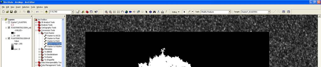
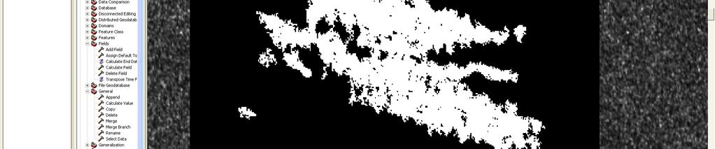
13 Methodology - Overview Obtain and filter the MMS Platform data files to determine the current platform positions in the Gulf of Mexico. Process SAR imagery for target detection and wind speed Import results into the NOAA database and perform additional internal database processing and table updates Generate a list of missing platforms with platform type and prior detection probabilities Find the SAR detections in a particular image that are within a few hundred meters of the MMS positions. NOAA Post Hurricane Platform Evaluation Image: HH-ALPSRP H1.5_UA Acquired: 18-SEP-08 04:36:47 There are 136 MMS Platform Locations covered by this image There are 12 MMS Platform Locations that were NOT detected in this image These results are shown graphically on slide 22 Complex_Id MMS_Latitude MMS_Longitude SAR_Latitude SAR_Longitude Prior_Detections Prior Observatio Historical P_Det Type * % FIXED No SAR Detection FIXED * % FIXED * % FIXED * % FIXED * % FIXED * % FIXED * % FIXED No SAR Detection FIXED * % FIXED % FIXED No SAR Detection FIXED
14 Methodology (Detail) MMS-C MMS-B MMS-A MMS Database Files (ASCII) Level-1 SAR Imagery NOAA Processing Metadata Ship Detection Positions (ASCII/GIS) Wind Speed Data (NetCDF) MMS-C MMS-B MMS-A Processing / Filtering MMS Table Id/Lat/Lon/Type Spatial Queries and Table Updates Image Metadata Table Date/Time/Image Region # of Covered MMS Platforms Detections Table Lat/Lon/Corrections Conditions Table Platform Position Wind Speed/Direction/Geometry Oracle Database Detections Results Table Lat/Lon/Corrections Detection Processing (MATLAB)


15 2008 Hurricanes - Gustav Gustav 1-Sep-08 03:59 Gustav Track (JHU/APL Hurricane Website) AVHRR IR Channel 4 1 Sept :04 UT


16 2008 Hurricanes Ike Ike 13-Sep-08 04:23 Gustav Track (JHU/APL Hurricane Website) AVHRR IR CH4 13 Sept. 2008, 04:02 UT
 with no associated removal date 3263 distinct positions with 3251 distinct complex")
17 Ike Sustained Winds and Destroyed Platforms MMS Assessed Destroyed (60) Damaged (31) 3363 platform positions recorded in the MMS database (Sept 2008) with no associated removal date 3263 distinct positions with 3251 distinct complex identifications

18 SAR Coverage Post Ike September 2008 Destroyed (60) Damaged (31) RADARSAT-1 Wide 16-SEP-08 ENVISAT Standard 17-SEP-08 ALOS Standard 18-SEP-08

 8 Destroyed platforms with SAR returns Oil")
19 PALSAR Results 18 Sep 2008 Image 550 Red - Destroyed SAR returns from destroyed platforms MMS positions with no SAR returns Oil Spill 136 MMS platform positions covered by this image 8 of 16 Destroyed platforms designated as missing (M) 8 Destroyed platforms with SAR returns Oil Spill
20 2008 Gustav / Ike Summary NOAA STAR has in place a working system that uses SAR imagery to identify oil platforms that are missing after tropical events in the Gulf of Mexico. Ike Identified 12 of 25 platforms in the imaged area that were subsequently declared destroyed by MMS. The remaining 13 platforms all had strong SAR returns. Five platforms had associated oil spills Destroyed does not equal not visible There were an additional 28 missing declarations for an imaged region covering 598 platform positions We are investigating and characterizing the missing declarations Platform is not detectable (Size/Type/Wind Conditions) Believe it is related to platform size. Many missing declarations are caissons/well protectors pipes sticking out of the water A possible way to improve results is to systematically collect standard mode imagery over the region and develop a SAR derived platform location baseline / database
21 NOAA Development and Improvement Work Refine and streamline the platform detection technique Determine the best method to ensure accurate pixel location to latitude/longitude conversion Should be able to refine the proximity distance between SAR and MMS to better the 800 meters Develop a method to improve the results from wideswath imagery High near range returns overwhelm the target detection Improve the prior detection probability calculation Integrate environmental conditions (wind speed) Investigate the roles of wind speed/resolution/polarization/incidence angle/platform size Preseason survey would help with prioritizing post event results Investigate the relative merits of C-band vs. L-Band (vs. X-band) Develop the capability to process, Radarsat-2, TerraSAR-X, and COSMO-SkyMed
22 Current Activities Season Work with MMS to get a better understanding of their current platform database Pre-season survey with ENVISAT/ALOS/RADARSAT-2 Establish a SAR-based list of detected platforms Gain experience with ALOS and RADARSAT-2 Have in place the system for scheduling acquisitions and obtaining the data Short lead time satellite acquisition programming incurs extra cost Develop a post hurricane collection plan Determine where, relative to the hurricane track, to focus acquisitions Develop capability to rapidly determine the best mix of acquisitions from the available SAR satellites

23 2009 Pre-Season Survey Envisat - Descending Filled on 14 July 2009 with a NGA sponsored Radarsat-2 collection

24 2009 Pre-Season Survey Envisat - Ascending
25 Concept of Operations To be most useful the post hurricane oil platform evaluation must be done in days 1-5 after an event This timeline can only be accommodated by having access to all 9 of the commercially available SARs No control over when and where the hurricane strikes vs. orbital phase of the satellites Focus will be on high incidence angle 100 km swath imagery for oil platforms/rigs If high incidence angle coverage is not possible we will collect large area wide swath coverage for evaluation of oil spills Approximately 72 hours before the storm reaches the oil platform region, a decision will need to be made on whether a post-event data collection will be done. This is necessary to get the first image on the day after the storm passes. Minerals Management Service / FEMA decision After deciding to collect NOAA NESDIS will work with MMS/FEMA to determine the collection region With the collection region defined NOAA will then work with CSTARS or other acquisition stations to schedule data collections Example on the following slide
26 Oil Spill Mapping Purpose: To develop interactive methods of rapidly assessing whether there are any anomalies in the ocean that may be associated with oil spills or natural oil seeps, especially used following tropical events. Motivation: If wide-area assessments can be made of oil spills within 1-3 days after hurricane landfall or ship accident while underway or docked, then reconnaissance flights can be carried out much more efficiently resulting in significant savings and perhaps increased safety. Requestors: National Ocean Service Emergency Response Division Response agencies and companies Minerals Management Service U.S. Coast Guard


27 Slick ESA, 2008 CSA, 2008 Possible oil spills after Hurricane Ike, September Left - Image of Calcasieu Lake, LA with slick, Sep. 16. Above South of New Orleans in Gulf of Mexico, Sep. 14.


28 ESA, 2009 Pipeline Spill Gulf of Mexico July 26, 2009 ENVISAT ASAR
29 Pipeline Spill Gulf of Mexico - July 26, 2009 ENVISAT ASAR ESA, 2009

30 Pipeline Spill, Gulf of Mexico July 27, 2009 ALOS PALSAR JAXA, 2009

31 Pipeline Spill, Gulf of Mexico, July 29, 2009 ENVISAT ASAR ESA, 2009

32 Pipeline Spill Gulf of Mexico - July 26, 2009 ENVISAT ASAR ESA, 2009

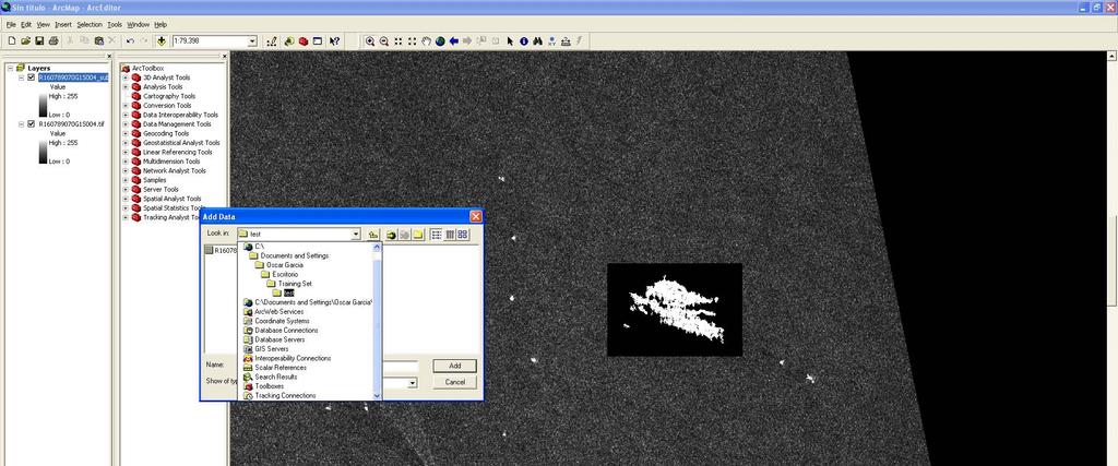
33 Texture Classifying Neural Network Algorithm Oscar Garcia-Pineda - Florida State University

")
34 Texture Classifying Neural Network Algorithm (TCNNA) Oscar Garcia-Pineda


 Texture Features")
35 Data Integration Approach Four types of Data Integrated: Satellite Variables e.g. (Incidence Angle, Beam Mode) Texture Features Neighborhood Environmental Data


36 Mapping Oil Spills
37 Development of Operational Oil Spill Mapping Capability in NOAA Steps to Operations: Transition manual analysis and data scheduling/ordering to SAB from STAR Migrate the Canadian Ice Service ISTOP Oil Spill Analysis System to NESDIS/SAB Develop algorithms for oil slick mapping to be used as analyst tools Analyze spills in an experimental mode until operational SAR data are available Begin operational production with Sentinel-1, ALOS-2, and RADARSAT Constellation Mission
38 Summay ALOS PALSAR research in NOAA has resulted in: Initial wind imagery Vessel positions Integration of ALOS into oil spill analysis activities Use of ALOS PALSAR for post-hurricane oil platform change detection Work to be done: Validation of winds and vessel positions with sea truth information Operational processing systems development and implementation By July 2011 for winds and oil spills After that for vessel positions, oil platform change detection, river ice and other applications. Use of multi-polarization PALSAR modes
39 SAR Ocean Monitoring Web Sites 1. Alaska SAR Demonstration: NOAA: APL: ASF: / 2. GhostNet Home Page: 3. SAR Marine Users Manual - Global Ocean Associates site: 4. SAR Wind User s Guide - SSARGASSO site:
Training Course on Radar & Optical RS, IES, Cēsis, Latvia, 5-9 September SAR Marine Applications. Wind and Waves
 SAR Marine Applications Wind and Waves Martin Gade Uni Hamburg, Institut für Meereskunde martin.gade@uni-hamburg.de SAR Marine Applications Friday, 9 Sep, Morning: 1 - History & Basics Introduction Radar/SAR
Davida Streett NOAA/NESDIS. NESDIS Satellite Analysis Branch Hazard Mitigation Programs
 ESA 2010 Oil Davida Streett NOAA/NESDIS NESDIS Satellite Analysis Branch Hazard Mitigation Programs Operational 24 x 7 x 365 Fire and Smoke Precipitation Tropical Storms/Hurricanes Oil/Marine Pollution
ROUTINE PRODUCTION OF SAR-DERIVED ICE AND OCEAN PRODUCTS IN THE UNITED STATES
 ROUTINE PRODUCTION OF SAR-DERIVED ICE AND OCEAN PRODUCTS IN THE UNITED STATES William G. Pichel (1), Pablo Clemente-Colón (1), Cheryl Bertoia (3,2), Michael Van Woert (1,2), Christopher C. Wackerman (4),
Amina Rangoonwala and Elijah Ramsey III Wetland and Aquatic Research Center. U.S. Geological Survey. Lafayette, LA
 First I will show examples of radar mapping of hurricane surge extent and duration and optical mapping of the resultant marsh dieback along the Louisiana coast Next we extend these works to hurricane Sandy
EXTRACTION OF FLOODED AREAS DUE THE 2015 KANTO-TOHOKU HEAVY RAINFALL IN JAPAN USING PALSAR-2 IMAGES
 EXTRACTION OF FLOODED AREAS DUE THE 2015 KANTO-TOHOKU HEAVY RAINFALL IN JAPAN USING PALSAR-2 IMAGES F. Yamazaki a, *, W. Liu a a Chiba University, Graduate School of Engineering, Chiba 263-8522, Japan
J2.6 SONAR MEASUREMENTS IN THE GULF STREAM FRONT ON THE SOUTHEAST FLORIDA SHELF COORDINATED WITH TERRASAR-X SATELLITE OVERPASSES
 J2.6 SONAR MEASUREMENTS IN THE GULF STREAM FRONT ON THE SOUTHEAST FLORIDA SHELF COORDINATED WITH TERRASAR-X SATELLITE OVERPASSES Chris Maingot 1, Alexander Soloviev 1, Silvia Matt 1, Mikhail Gilman 1,
Ocean Surface Wind Speed of Hurricane Helene Observed by SAR
 Available online at www.sciencedirect.com Procedia Environmental Sciences 10 (2011 ) 2097 2101 2011 3rd International Conference on Environmental Science and Information Conference Application Title Technology
GEOSC/METEO 597K Kevin Bowley Kaitlin Walsh
 GEOSC/METEO 597K Kevin Bowley Kaitlin Walsh Timeline of Satellites ERS-1 (1991-2000) NSCAT (1996) Envisat (2002) RADARSAT (2007) Seasat (1978) TOPEX/Poseidon (1992-2005) QuikSCAT (1999) Jason-2 (2008)
Opportunities for advanced Remote Sensing; an outsider s perspective
 Opportunities for advanced Remote Sensing; an outsider s perspective Ramon Hanssen Delft University of Technology 1 Starting questions Can we do more with the data we are already acquire? What s in stock
Monitoring Sea Ice with Space-borne Synthetic Aperture Radar
 Monitoring Sea Ice with Space-borne Synthetic Aperture Radar Torbjørn Eltoft UiT- the Arctic University of Norway CIRFA A Centre for Research-based Innovation cirfa.uit.no Sea ice & climate Some basic
New Era of Global Monitoring by ALOS-2: Advanced Land Observing Satellite-2 DAICHI-2 Yuko Suzuki
 New Era of Global Monitoring by ALOS-2: Advanced Land Observing Satellite-2 DAICHI-2 Yuko Suzuki International Relations and Research Department Japan Aerospace Exploration Agency (JAXA) 1 Dawning Era
Why Hydrological Services are Important to Business
 Why Hydrological Services are Important to Business Dr. David Green Program Manager, Disasters Earth Science Division David.s.green@nasa.gov May 8, 2018 2 Communities and Areas of Intensive Risk Socio-Economic
Add NOAA nowcoast Layers to Maps
 WebEOC Maps Add-on Quick Reference Guide Add NOAA nowcoast Layers to Maps Overview With Maps Add-on, you can configure an unlimited number of map layers. These layers allow you to control the data you
DLR s TerraSAR-X contributes to international fleet of radar satellites to map the Arctic and Antarctica
 DLR s TerraSAR-X contributes to international fleet of radar satellites to map the Arctic and Antarctica The polar regions play an important role in the Earth system. The snow and ice covered ocean and
SAR Training Course, MCST, Kalkara, Malta, November SAR Maritime Applications. Wind and Waves
 SAR Maritime Applications Wind and Waves Martin Gade Uni Hamburg, Institut für Meereskunde SAR Maritime Applications Thursday, 13 Nov.: 1 - History & Basics Introduction Radar/SAR History Basics Scatterometer
NOAA/NESDIS Contributions to the International Polar Year (IPY)
") NOAA/NESDIS Contributions to the International Polar Year (IPY) WMO Space Task Group for IPY 5-66 May 2008 Frascati, Italy Jeff Key and Pablo Clemente-Col Colón Overview NESDIS is responsible for operational
NOAA/NESDIS Contributions to the International Polar Year (IPY) WMO Space Task Group for IPY 5-66 May 2008 Frascati, Italy Jeff Key and Pablo Clemente-Col Colón Overview NESDIS is responsible for operational
Currents and Objects
 SAR Marine Applications Currents and Objects Martin Gade Uni Hamburg, Institut für Meereskunde martin.gade@uni-hamburg.de SAR Maritime Applications Friday, 9 Sep, Morning: 1 - History & Basics Introduction
Application of Wavelet Spectrum Analysis to Oil Spill Detection by Using Satellite Observation Data
 PAJ Oil Spill Symposium 2008 Application of Wavelet Spectrum Analysis to Oil Spill Detection by Using Satellite Observation Data February 21, 2008 Tokyo, Japan Masanao Hara Dr., VisionTech Inc. 1. Background
Improved sea-ice monitoring for the Baltic Sea Project summary
 Improved sea-ice monitoring for the Baltic Sea Project summary Leif E.B. Eriksson (1), Karin Borenäs (2), Wolfgang Dierking (3), Anders Berg (1) and Per Pemberton (2) (1) Chalmers University of Technology,
Use of Satellite Earth Observations, in situ data and numerical model capabilities for oil spill contingency. Page 1
 Use of Satellite Earth Observations, in situ data and numerical model capabilities for oil spill contingency Page 1 Oil spill service Page 2 Interest of Earth-Observation (EO) data for oil and gas companies
Current Status of the ALOS-2 Operation and PALSAR-2 Calibration Activities
 Current Status of the ALOS-2 Operation and PALSAR-2 Calibration Activities Takeshi Motohka, Ryo Natsuaki, Yukihiro Kankaku, Shinichi Suzuki, Masanobu Shimada (JAXA) Osamu Isoguchi (RESTEC) CEOS SAR CALVAL
HY-2A Satellite User s Guide
 National Satellite Ocean Application Service 2013-5-16 Document Change Record Revision Date Changed Pages/Paragraphs Edit Description i Contents 1 Introduction to HY-2 Satellite... 1 2 HY-2 satellite data
Monitoring of Arctic Conditions from a Virtual Constellation of Synthetic Aperture Radar Satellites
 DISTRIBUTION STATEMENT A. Approved for public release; distribution is unlimited. Monitoring of Arctic Conditions from a Virtual Constellation of Synthetic Aperture Radar Satellites Hans C. Graber RSMAS
New NASA Ocean Observations and Coastal Applications
 New NASA Ocean Observations and Coastal Applications Duane Armstrong Chief, Applied Science & Technology Project Office August 20, 2014 1 Outline NASA s new Earth Science Ocean Science Missions for 2014
Overview of the Tropical Cyclone Guidance Project
 Overview of the Tropical Cyclone Guidance Project Dr. Jonathan L. Vigh With thanks to Mahsa Mirzargar (Univ. of Miami) Shanghai Typhoon Institute 09 July 2018 NCAR is sponsored by the National Science
Canadian Space Agency Update. STG 3 ESRIN, Frascati May 5-6, 2008 Yves Crevier
 Canadian Space Agency Update STG 3 ESRIN, Frascati May 5-6, 2008 Yves Crevier Role of CSA in IPY Ensure the use of Space Technologies in IPY Science initiatives Guarantee fluid and continued availability
NOAA and National Ice Center (NIC) Activities and Future Synthetic Aperture Radar (SAR) Applications and Operational Needs
 Activities and Future Synthetic Aperture Radar (SAR) Applications and Operational Needs") NOAA and National Ice Center (NIC) Activities and Future Synthetic Aperture Radar (SAR) Applications and Operational Needs PSTG 4th Session GSFC, Greenbelt, MD September 30, 2014 Pablo Clemente-Colón U.S.
NOAA and National Ice Center (NIC) Activities and Future Synthetic Aperture Radar (SAR) Applications and Operational Needs PSTG 4th Session GSFC, Greenbelt, MD September 30, 2014 Pablo Clemente-Colón U.S.
Low-Backscatter Ocean Features in Synthetic Aperture Radar Imagery
 P. CLEMENTE-COLÓN AND X-H. YAN Low-Backscatter Ocean Features in Synthetic Aperture Radar Imagery Pablo Clemente-Colón and Xiao-Hai Yan Many ocean surface signatures in synthetic aperture radar (SAR) imagery
SAR-based wind climatology for wind turbines
 Downloaded from orbit.dtu.dk on: Dec 16, 2017 SAR-based wind climatology for wind turbines Badger, Merete; Hasager, Charlotte Bay; Nielsen, Morten; Astrup, Poul; Badger, Jake; Mortensen, Niels Gylling;
DUAL-POLARIZED COSMO SKYMED SAR DATA TO OBSERVE METALLIC TARGETS AT SEA
 DUAL-POLARIZED COSMO SKYMED SAR DATA TO OBSERVE METALLIC TARGETS AT SEA F. Nunziata, M. Montuori and M. Migliaccio Università degli Studi di Napoli Parthenope Dipartimento per le Tecnologie Centro Direzionale,
Center for Southeastern Tropical Advanced Remote Sensing (CSTARS)
") DISTRIBUTION STATEMENT A: Distribution approved for public release; distribution is unlimited Center for Southeastern Tropical Advanced Remote Sensing (CSTARS) Hans C. Graber CSTARS - University of Miami
DISTRIBUTION STATEMENT A: Distribution approved for public release; distribution is unlimited Center for Southeastern Tropical Advanced Remote Sensing (CSTARS) Hans C. Graber CSTARS - University of Miami
RADARSAT-1 Hurricane Watch program contribution to wind field model development
 RADARSAT-1 Hurricane Watch program contribution to wind field model development Steve Iris 1, Hans C. Graber 2 1 Canadian Space Agency, St-Hubert, Quebec, J3Y 8Y9, Canada - steve.iris@space.gc.ca 2 CSTARS
Hurricane Katrina and Oil Spills: Impact on Coastal and Ocean Environments
 Archived version from NCDOCKS Institutional Repository http://libres.uncg.edu/ir/asu/ Pine, J. C. (June 2006). Hurricane Katrina and oil spills: Impact on coastal and ocean environments. Oceanography,
Annex VI-1. Draft National Report on Ocean Remote Sensing in China. (Reviewed by the Second Meeting of NOWPAP WG4)
") UNEP/NOWPAP/CEARAC/WG4 2/9 Page1 Draft National Report on Ocean Remote Sensing in China (Reviewed by the Second Meeting of NOWPAP WG4) UNEP/NOWPAP/CEARAC/WG4 2/9 Page1 1. Status of RS utilization in marine
UNEP/NOWPAP/CEARAC/WG4 2/9 Page1 Draft National Report on Ocean Remote Sensing in China (Reviewed by the Second Meeting of NOWPAP WG4) UNEP/NOWPAP/CEARAC/WG4 2/9 Page1 1. Status of RS utilization in marine
Ice & Snow Session. Chairs: J. Mouginot & N. Gourmelen
 Ice & Snow Session Chairs: J. Mouginot & N. Gourmelen Session 12 talks and 10 posters Antarctic ice motion, ground-line detection and monitoring, dynamics ice-fluctuations in Antarctica and Greenland,
Wind Direction Estimates from Synthetic Aperture Radar Imagery of the Sea Surface
 Wind Direction Estimates from Synthetic Aperture Radar Imagery of the Sea Surface George S. Young The Pennsylvania State University 503 Walker Building University Park, PA 16803 phone: (814) 863-4228 fax:
Sentinel-1 Mission Status
 Sentinel-1 Mission Status Pierre Potin, Sentinel-1 Mission Manager, ESA Luca Martino, Technical Support Engineer, ESA... and the Sentinel-1 operations team PSTG SAR Coordination Working Group 14 December
NASA Jet Propulsion Laboratory Data Products
 NASA Jet Propulsion Laboratory Data Products 17 April 2014 Emergency Response Spatial Tools Technical Interchange Maggi Glasscoe Margaret.T.Glasscoe@jpl.nasa.gov Sang-Ho Yun Sang-Ho.Yun@jpl.nasa.gov www.nasa.gov
Hurricane Katrina Tracking Lab
 Hurricane Katrina Tracking Lab Introduction: The 2005 hurricane season was the most active season on record resulting in 28 named storms. Hurricane Katrina was the eleventh named storm and would end up
ASSESSMENT AND RESTORATION OF COASTAL ECOSYSTEMS USING REMOTE SENSING AND VISUALIZATION TOOLS FOR THE GULF OF MEXICO AND BEYOND
 ASSESSMENT AND RESTORATION OF COASTAL ECOSYSTEMS USING REMOTE SENSING AND VISUALIZATION TOOLS FOR THE GULF OF MEXICO AND BEYOND Remote Sensing as a Tool for Ecosystem Restoration George Graettinger Office
The ESA Earth observation programmes overview and outlook
 The ESA Earth observation programmes overview and outlook Dr. Volker Liebig Director, ESA EO Programmes ILA 2008, Berlin ENVISAT mission: 6 years! Bam earthquake Tectonic uplift (Andaman) Arctic 2007 First
Hurricane Season 2010 & NOAA s Deepwater Response
 Hurricane Season 2010 & NOAA s Deepwater Response What s Happened? What Will 2010 Bring? Possible Shoreline Effects Darin Figurskey Meteorologist-in-Charge NOAA s NWS Raleigh, NC NOAA s National Weather
Sentinel-1 Mission Status
 Sentinel-1 Mission Status Pierre Potin, Sentinel-1 Mission Manager 5TH GEOGLAM RAPP Workshop 16-17 May 2017, ESRIN Sentinel-1: Copernicus radar imaging mission for ocean, land, emergency Part of the Copernicus
The UW-CIMSS Advanced Dvorak Technique (ADT) : An Automated IR Method to Estimate Tropical Cyclone Intensity
 : An Automated IR Method to Estimate Tropical Cyclone Intensity") The UW-CIMSS Advanced (ADT) : An Automated IR Method to Estimate Tropical Cyclone Intensity Timothy Olander and Christopher Velden University of Wisconsin Madison, USA Cooperative Institute for Meteorological
The UW-CIMSS Advanced (ADT) : An Automated IR Method to Estimate Tropical Cyclone Intensity Timothy Olander and Christopher Velden University of Wisconsin Madison, USA Cooperative Institute for Meteorological
Infrastructure monitoring using SAR interferometry
 Infrastructure monitoring using SAR interferometry Hossein Nahavandchi Roghayeh Shamshiri Norwegian University of Science and Technology (NTNU), Department of Civil and Environmental Engineering Geodesy
ECVs: What s operational and what still requires R&D?
 Glaciers_cci input on ECVs: What s operational and what still requires R&D? Frank Paul* Department of Geography, University of Zurich *on behalf of the Glaciers_cci consortium Google Earth Operational
NOAA Great Lakes CoastWatch Program
 Great Lakes Workshop Series on Remote Sensing of Water Quality May 7-8, 2014 NOAA GLERL, 4840 South State Rd, Ann Arbor, MI NOAA Great Lakes CoastWatch Program CoastWatch is a nationwide National Oceanic
Ice surveys, meteorological and oceanographic data What is available and up-to-date?
 Ice surveys, meteorological and oceanographic data What is available and up-to-date? Leader of the Norwegian Ice Service +47 77 62 13 15 - nick.hughes@met.no Norwegian Meteorological Institute met.no 1
Satellite SAR wind resource mapping in China (SAR-China)
") Downloaded from orbit.dtu.dk on: Feb 26, 2019 Satellite SAR wind resource mapping in China (SAR-China) Badger, Merete Publication date: 2009 Document Version Publisher's PDF, also known as Version of record
Downloaded from orbit.dtu.dk on: Feb 26, 2019 Satellite SAR wind resource mapping in China (SAR-China) Badger, Merete Publication date: 2009 Document Version Publisher's PDF, also known as Version of record
OCEAN SURFACE DRIFT BY WAVELET TRACKING USING ERS-2 AND ENVISAT SAR IMAGES
 OCEAN SURFACE DRIFT BY WAVELET TRACKING USING ERS-2 AND ENVISAT SAR IMAGES Antony K. Liu, Yunhe Zhao Ocean Sciences Branch, NASA Goddard Space Flight Center, Greenbelt, Maryland, USA Ming-Kuang Hsu Northern
ASCAT NRT Data Processing and Distribution at NOAA/NESDIS
 ASCAT NRT Data Processing and Distribution at NOAA/NESDIS Paul S. Chang, Zorana Jelenak, Seubson Soisuvarn, Qi Zhu Gene Legg and Jeff Augenbaum National Oceanic and Atmospheric Administration (NOAA) National
EO-Based Ice and Iceberg Monitoring in Support of Offshore Engineering Design and Tactical Operations
 EO-Based Ice and Iceberg Monitoring in Support of Offshore Engineering Design and Tactical Operations Desmond Power, C-CORE ESA Industry Workshop on Satellite EO for the Oil and Gas Sector Overview Operations
EONav Satellite data in support of maritime route optimization
 EONav Satellite data in support of maritime route optimization Leif Eriksson Department of Space, Earth and Environment Chalmers University of Technology Outline Why is maritime navigation support needed?
Homework 9: Hurricane Forecasts (adapted from Pipkin et al.)
") November 2010 MAR 110 HW9 Hurricane Forecasts 1 Homework 9: Hurricane Forecasts (adapted from Pipkin et al.) Movement of Hurricanes The advance of a tropical storm or hurricane is controlled by the prevailing
November 2010 MAR 110 HW9 Hurricane Forecasts 1 Homework 9: Hurricane Forecasts (adapted from Pipkin et al.) Movement of Hurricanes The advance of a tropical storm or hurricane is controlled by the prevailing
Wind Direction Estimates from Synthetic Aperture Radar Imagery of the Sea Surface
 Wind Direction Estimates from Synthetic Aperture Radar Imagery of the Sea Surface George S. Young 503 Walker Building Department of Meteorology The Pennsylvania State University University Park, Pennsylvania
NEW CGMS BASELINE FOR THE SPACE-BASED GOS. (Submitted by the WMO Secretariat) Summary and Purpose of Document
 Summary and Purpose of Document") WORLD METEOROLOGICAL ORGANIZATION COMMISSION FOR BASIC SYSTEMS OPEN PROGRAMME AREA GROUP ON INTEGRATED OBSERVING SYSTEMS EXPERT TEAM ON SATELLITE SYSTEMS ET-SAT-7/Inf. 2 (12.III.2012) ITEM: 8.1 SEVENTH
WORLD METEOROLOGICAL ORGANIZATION COMMISSION FOR BASIC SYSTEMS OPEN PROGRAMME AREA GROUP ON INTEGRATED OBSERVING SYSTEMS EXPERT TEAM ON SATELLITE SYSTEMS ET-SAT-7/Inf. 2 (12.III.2012) ITEM: 8.1 SEVENTH
The Atlantic Hurricane Database Reanalysis Project
 The Atlantic Hurricane Database Reanalysis Project 9 November, 2015 14 th International Workshop on Wave Hindcasting and Forecasting Chris Landsea, National Hurricane Center, Miami, USA Chris.Landsea@noaa.gov
Wave processes in Arctic Seas, observed from TerraSAR-X
 DISTRIBUTION STATEMENT A. Approved for public release; distribution is unlimited. Wave processes in Arctic Seas, observed from TerraSAR-X Susanne Lehner DLR German Air and Space Research Center Earth Observation
CopernicusEU. the EU's Earth Observation Programme. Sara Zennaro Atre Delegation of the European Union to Japan
 Copernicus the EU's Earth Observation Programme Sara Zennaro Atre Delegation of the European Union to Japan Status Overview, Sept 2016 & Ocean Policies Seminar 4 October 2016 ollow us on: Copernicus EU
an accessible interface to marine environmental data Russell Moffitt
 an accessible interface to marine environmental data Russell Moffitt The Atlas Project GOAL: To provide a single point of access to oceanographic and environmental data for use by marine resource researchers,
Environmental Data In Support of Search & Rescue Operations in the Central Mediterranean Sea
 Environmental Data In Support of Search & Rescue Operations in the Central Mediterranean Sea Dr. Eric Comerma (RPS ASA) eric.comerma@rpsgroup.com Cathleen Turner (RPS ASA) Prof. Aldo Drago (Univ. of Malta)
Climate Change Impacts in Alaska: the Weather Perspective
 Climate Change Impacts in Alaska: the Weather Perspective September 18, 2007 NOAA s National Weather Service, Alaska Region James Partain, Chief Environmental and Scientific Services Division NOAA NWS
Mapping Surface Oil Extent from the Deepwater Horizon Oil Spill Using ASCAT Backscatter
 Mapping Surface Oil Extent from the Deepwater Horizon Oil Spill Using ASCAT Backscatter Richard D. Lindsley and David G. Long Microwave Earth Remote Sensing Laboratory Brigham Young University Provo, UT
Floating Ice: Progress in Addressing Science Goals
 Polar Floating Ice: Progress in Addressing Science Goals Stephen Howell 1, Leif Toudal Pedersen 2 and Roberto Saldo 3 1 Environment Canada, Climate Research Division, Toronto, Canada 2 Danish Meteorological
Direct Readout at the Meteorological Service of Canada
 Direct Readout at the Meteorological Service of Canada CSPP Users Meeting 2015 Darmstadt, Germany April 14-16, 2015 David Bradley Manager, Earth Observation and Geomatics Meteorological Service of Canada
Sentinel-1 Long Duration Mutual Interference
 MPC-S1 Sentinel-1 Long Duration Mutual Interference Reference: Nomenclature: MPC-0432 DI-MPC-ARC Issue: 1. 0 Date: 2018,Dec.04 MPC-0432 DI-MPC-ARC V1.0 2018,Dec.04 i.1 Chronology Issues: Issue: Date: Reason
Sentinel and ESA Third-Party Mission data access and processing tools
 Sentinel and ESA Third-Party Mission data access and processing tools Magdalena Fitrzyk RSAC c/o ESA ESRIN 11/09/2018 Content Copernicus Sentinel missions Copernicus Open Access Hub: Sentinels Data Access
K&C Phase 4 Status report. Ice Sheet Monitoring using ALOS-2. University of California, Irvine 2 JPL
 K&C Phase 4 Status report Ice Sheet Monitoring using ALOS-2 Bernd Scheuchl 1, Jeremie Mouginot 1, Eric Rignot 1,2 1 University of California, Irvine 2 JPL Science Team meeting #24 Tokyo, Japan, January
National Satellite Data Centre and Finnish Sentinel Collaborative Ground Segment. Jyri Heilimo Finnish Meteorological Instute
 National Satellite Data Centre and Finnish Sentinel Collaborative Ground Segment Jyri Heilimo Finnish Meteorological Instute Sodankylä National Satellite Data Centre National satellite data centre providing
The Polar Ice Sheets Monitoring Project A Coordinated Response from Space Agencies
 The Polar Ice Sheets Monitoring Project A Coordinated Response from Space Agencies Yves Crevier / Members of the PSTG SAR Coordination WG Canadian Space Agency CEOS SIT-28 Meeting Hampton, Virginia, USA
esurge A Storm Surge Demonstration Project
 esurge A Storm Surge Demonstration Project Helen Snaith British Oceanographic Data Centre, National Oceanography Centre, UK The Impact of Storm Surges Great flood in the Netherlands History: Zeeland, 31
Evolution of NOAA s Observing System Integrated Analysis (NOSIA)
") Evolution of NOAA s Observing System Integrated Analysis (NOSIA) Presented to the 13th Symposium on Societal Applications: Policy, Research and Practice (paper 9.1) Louis Cantrell Jr., and D. Helms, R.
Evolution of NOAA s Observing System Integrated Analysis (NOSIA) Presented to the 13th Symposium on Societal Applications: Policy, Research and Practice (paper 9.1) Louis Cantrell Jr., and D. Helms, R.
Remote Sensing I: Basics
 Remote Sensing I: Basics Kelly M. Brunt Earth System Science Interdisciplinary Center, University of Maryland Cryospheric Science Laboratory, Goddard Space Flight Center kelly.m.brunt@nasa.gov (Based on
Using Sea-level Pressure to Improve Surface Wind Retrievals Derived From Satellite Synthetic Aperture Radar Images of Tropical Cyclones
 Using Sea-level Pressure to Improve Surface Wind Retrievals Derived From Satellite Synthetic Aperture Radar Images of Tropical Cyclones Ralph Foster, APL, University of WA Jerome Patoux, Atmospheric Sciences,
Satellite-derived Wind, Cloud, and Surface Products at Direct Broadcast Sites in the Antarctic and Arctic
 Satellite-derived Wind, Cloud, and Surface Products at Direct Broadcast Sites in the Antarctic and Arctic William Straka III +, Jeff Key*, Dave Santek +, Matthew Lazzara #, Liam Gumley +, Kathy Strabala
SAR data Sensords and examples
 SAR data Sensords and examples Sar Technical Training for Forest Mapping 2014/2015 Cédric Lardeux Jean-Paul Rudant Pierre-Louis Frison cedric.lardeux@onfinternational.com rudant@univ-mlv.fr frison@univ-mlv.fr
Instituto de Ingeniería, UNAM, México SPILL-SATCON, Satellite Constellation Mission Idea to Detect Oil Spills in Oceans
 SPILL-SATCON, Satellite Constellation Mission Idea to Detect Oil Spills in Oceans Dr. Esaú Vicente Vivas, Instituto de Ingeniería (II), UNAM, evv@unam.mx, C.Dr. Adán Espinoza Millán, Moscow State University,
Alaska Ocean Observing System 101 Anchorage, Alaska
 Alaska Ocean Observing System 101 Anchorage, Alaska Molly McCammon, Director Alaska Ocean Observing System (AOOS) A Regional Observing System within the Integrated Ocean Observing System www.aoos.org IOOS
ANALYSIS OF ASAR POLARISATION SIGNATURES FROM URBAN AREAS (AO-434)
") ANALYSIS OF ASAR POLARISATION SIGNATURES FROM URBAN AREAS (AO-434) Dan Johan Weydahl and Richard Olsen Norwegian Defence Research Establishment (FFI), P.O. Box 25, NO-2027 Kjeller, NORWAY, Email: dan-johan.weydahl@ffi.no
ANALYSIS OF ASAR POLARISATION SIGNATURES FROM URBAN AREAS (AO-434) Dan Johan Weydahl and Richard Olsen Norwegian Defence Research Establishment (FFI), P.O. Box 25, NO-2027 Kjeller, NORWAY, Email: dan-johan.weydahl@ffi.no
The Field Research Facility, Duck, NC Warming Ocean Observations and Forecast of Effects
 The Field Research Facility, Duck, NC Warming Ocean Observations and Forecast of Effects A potential consequence of a warming ocean is more frequent and more intense wind events (Hurricanes & Typhoons)
Synthetic Aperture Radar Imagery of the Ocean Surface During the Coastal Mixing and Optics Experiment
 Synthetic Aperture Radar Imagery of the Ocean Surface During the Coastal Mixing and Optics Experiment LONG TERM GOAL Donald R. Thompson and David L. Porter Ocean Remote Sensing Group Johns Hopkins University/APL
HVX-HURREVAC (Beta) Webinar Series
 Webinar Series") HVX-HURREVAC (Beta) Webinar Series Day 1 - An introduction to HURREVAC and the new web-based HVX platform 2018 HVX-HURREVAC Webinar Series 1. Intro to HURREVAC and General Overview of the Program (August
HVX-HURREVAC (Beta) Webinar Series Day 1 - An introduction to HURREVAC and the new web-based HVX platform 2018 HVX-HURREVAC Webinar Series 1. Intro to HURREVAC and General Overview of the Program (August
Observed Climate Variability and Change: Evidence and Issues Related to Uncertainty
 Observed Climate Variability and Change: Evidence and Issues Related to Uncertainty David R. Easterling National Climatic Data Center Asheville, North Carolina Overview Some examples of observed climate
LECTURE #18: Hurricane Damage, Monitoring & Case Study
 GEOL 0820 Ramsey Natural Disasters Spring, 2018 LECTURE #18: Hurricane Damage, Monitoring & Case Study Date: 27 March 2018 I. Exam II grades now posted online o high: 98, low: 46, average: 80 (~3 points
Using Remote Sensing Technologies to Improve Resilience
 4 Using Remote Sensing Technologies to Improve Resilience Ronald T. Eguchi CEO, ImageCat, Inc. 6 years ago The world had just survived the Y2K bug with no major incidents Nations around the world commit
Hurricane Wilma Post Storm Data Acquisition Estimated Peak Wind Analysis and Storm Tide Data. December 27, 2005
 Hurricane Wilma Post Storm Data Acquisition Estimated Peak Wind Analysis and Storm Tide Data December 27, 2005 Hurricane Wilma was the sixth major hurricane of the record-breaking 2005 Atlantic hurricane
Synthetic Weather Radar: Offshore Precipitation Capability
 Synthetic Weather Radar: Offshore Precipitation Capability Mark S. Veillette 5 December 2017 Sponsors: Randy Bass, FAA ANG-C6 and Rogan Flowers, FAA AJM-33 DISTRIBUTION STATEMENT A: Approved for public
Wind Tower Deployments and Pressure Sensor Installation on Coastal Houses Preliminary Data Summary _ Sea Grant Project No.
 Wind Tower Deployments and Pressure Sensor Installation on Coastal Houses Preliminary Data Summary _ Sea Grant Project No.:1020040317 Submitted to: South Carolina Sea Grant Consortium 287 Meeting Street
A Climatology of Landfalling Hurricane Central Pressures Along the Gulf of Mexico Coast
 A Climatology of Landfalling Hurricane Central Pressures Along the Gulf of Mexico Coast David H. Levinson NOAA National Climatic Data Center Asheville, NC Peter J. Vickery Applied Research Associates,
Satellite Remote Sensing for Ocean
 Satellite Remote Sensing for Ocean August 17, 2017 Masatoshi Kamei RESTEC All rights reserved RESTEC 2015 Contents 1. About RESTEC and Remote Sensing 2. Example of Remote Sensing Technology 3. Remote Sensing
DYNAMIC POSITIONING CONFERENCE October 7-8, Operations. Using GIS to Understand Hurricane Windfields in the Gulf of Mexico
 Return to Session Directory DYNAMIC POSITIONING CONFERENCE October 7-8, 2008 Operations Using GIS to Understand Hurricane Windfields in the Gulf of Mexico Jill F. Hasling and Maureen T. Maiuri Weather
PICTURE OF THE MONTH. Satellite Imagery of Sea Surface Temperature Cooling in the Wake of Hurricane Edouard (1996)
") 2716 MONTHLY WEATHER REVIEW VOLUME 125 PICTURE OF THE MONTH Satellite Imagery of Sea Surface Temperature Cooling in the Wake of Hurricane Edouard (1996) FRANK M. MONALDO Applied Physics Laboratory, The
2716 MONTHLY WEATHER REVIEW VOLUME 125 PICTURE OF THE MONTH Satellite Imagery of Sea Surface Temperature Cooling in the Wake of Hurricane Edouard (1996) FRANK M. MONALDO Applied Physics Laboratory, The
SNOW COVER MONITORING IN ALPINE REGIONS WITH COSMO-SKYMED IMAGES BY USING A MULTITEMPORAL APPROACH AND DEPOLARIZATION RATIO
 SNOW COVER MONITORING IN ALPINE REGIONS WITH COSMO-SKYMED IMAGES BY USING A MULTITEMPORAL APPROACH AND DEPOLARIZATION RATIO B. Ventura 1, T. Schellenberger 1, C. Notarnicola 1, M. Zebisch 1, T. Nagler
2006 & 2007 Pre-Hurricane Scenario Analyses
 2006 & 2007 Pre-Hurricane Scenario Analyses Executive Summary May 2007 Page 1 OF X FOR OFFICIAL USE ONLY 4 Public Availability to be Determined Under 5 U.S.C. 552 NOTE: Limited Distribution. Release of
sentinel-3 A BIGGER PICTURE FOR COPERNICUS
 sentinel-3 A BIGGER PICTURE FOR COPERNICUS SATELLITES TO SERVE By providing a set of key information services for a wide range of practical applications, Europe s Copernicus programme has been put in place
Outlook 2008 Atlantic Hurricane Season. Kevin Lipton, Ingrid Amberger National Weather Service Albany, New York
 Outlook 2008 Atlantic Hurricane Season Kevin Lipton, Ingrid Amberger National Weather Service Albany, New York Summary 2007 Hurricane Season Two hurricanes made landfall in the Atlantic Basin at category-5
Ice Observations on the Churchill River using Satellite Imagery
 CGU HS Committee on River Ice Processes and the Environment 15 th Workshop on River Ice St. John s, Newfoundland and Labrador, June 15-17, 2009 Ice Observations on the Churchill River using Satellite Imagery
Multisensor monitoring of Peter the Great Bay
 Multisensor monitoring of Peter the Great Bay Leonid Mitnik, Vyacheslav Dubina, Oleg Konstantinov and Vitaly Fischenko V.I. Il'ichev Pacific Oceanological Institute FEB RAS 43 Baltiyskaya St. 690041 Vladivostok,
Specification of Tropical Cyclone Parameters From Aircraft Reconnaissance. Andrew Cox and Vincent Cardone Oceanweather Inc.
 Specification of Tropical Cyclone Parameters From Aircraft Reconnaissance Andrew Cox and Vincent Cardone Oceanweather Inc. Cos Cob, CT, USA Motivation This paper is part of on-going work to improve the
Coastal Erosion & Climate Change: PRIDE 2005 Towards an Alaska Wind/Wave Climatology
 Coastal Erosion & Climate Change: PRIDE 2005 Towards an Alaska Wind/Wave Climatology 2 nd PRIDE Workshop August 9-10, 2005 David Atkinson, Int l Arctic Research Center, Univ. Of Alaska-Fairbanks James