National Satellite Data Centre and Finnish Sentinel Collaborative Ground Segment. Jyri Heilimo Finnish Meteorological Instute
|
|
|
- Cuthbert Black
- 6 years ago
- Views:
Transcription
1 National Satellite Data Centre and Finnish Sentinel Collaborative Ground Segment Jyri Heilimo Finnish Meteorological Instute


2 Sodankylä National Satellite Data Centre National satellite data centre providing satellite data reception, archiving and processing services to Finnish and international partners 2

3 Copernicus European Earth Observation Programme Copernicus is a European system for monitoring the Earth Programme collects data from multiple sources: satellites and in situ sensors Six thematic areas: land, marine, atmosphere, climate change, emergency management and security Main users: policymakers and public authorities, but also European Citizens 3

4 Copernicus Space Segment: The Sentinels Series of next-generation Earth observation missions Each mission will focus on a different aspect of Earth observation; Atmospheric, Oceanic, and Land monitoring, and the data will be of use in many applications. 4

5 Copernicus Ground Segment Finnish Collaborative Ground Segment 5

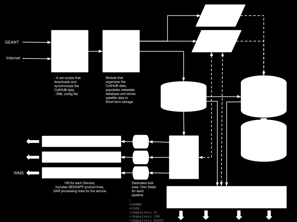
6 Finnish Collaborative GS Initiative Dissemination of Sentinel data to all users in Finland and neighbouring countries Enhance use of EO data and collaboration Batch pre-processing of the data Provide NRT / QRT data processing services to users Long-term archiving the Sentinel-data for scientific use Finnish CollGS will have 1. Collaborative Acquistion Station 2. Collaborative Archiving Centre Sentinel Core GS DHuS National Sentinel Mirror Archive S1, S2, S3, S5P National DHuS S5P UV SEN3APP S1 S2 S3 NRT data Sentinel 1 Spacecraft Sodankylä GS S-1 Reception Chain Sentinel-1 L0 L1 NRT data FMI Ice Service 6

7 Sentinel Collaborative Acquisition Station Local downlink of Sentinel-1 passthrough data to Sodankylä ground station Focus on NRT / QRT products Automated processing lines to enable very fast data delivery Data push directly to users Processes monitored 24/7 Current QRT data users: Baltic Sea Ice Service, Oil spill monitoring Current development status Satellite downlink system OSAT Succesful in Nov 2015 First S1A image downlinked at Sodankylä 7


8 First S1A image acquired during OSAT 8


9 Sample Service: Baltic Sea Ice Charting Commercial and environmental needs Finland is essentially an island ~90% of Finland s import and export via sea routes Gulf of Finland is one of the most busiest marine routes for oil transport SAR for sea ice charting Daily products for ice breakers and ships Previously RSAT2 used. COSMO-SkyMed used occationally Near real-time Sentinel-1 data from Sodankylä NSDC starting Winter 2015 Provided for Finnish and Swedish icebreakers. Estonian icebreakers under negotiation. COSMO-SkyMed Product ASI Distributed by e-geos. All Rights Reserved 9

10 Sentinel-1 SAR mosaic over the Barents and Kara Seas, 1 Mar
 available on-line Long-term data archive (6+ months - ) off-line Automated data processing lines for specific and local")
11 Sentinel Collaborative Archiving Centre Mirrors a subset of Sentinel data S1, S2, S3 and S5-P Provision of Sentinel data to Sentinel data users in Finland and in neighbouring countries free of charge Batch processing of the data to national grid Medium-term archive (3-6 months) available on-line Long-term data archive (6+ months - ) off-line Automated data processing lines for specific and local area products E.g. water quality, snow extent, Global UV Hosting of external processing services Development status: DHuS installation planned Winter 2015 Calvalus installation planned Autumn 2015 Sentinel-1 AoI 11

12 Sentinel-2 Archiving and dissemination of Sentinel-2 to national EO data users Automatic batch processing to Finnish DEM (planned) L1C uses 90m SRTM L1A -> KM10/KM25 Water quality processing Calvalus cluster processing system for large data sets and long time series processing Sentinel-2 data download to NSDC starts once routinely available from ESA. Sentinel-2 AoI Image: ESA 12

13 Sample Service: Operative Flood detection with Sentinel-1 Flooding rivers and lakes are easily detected from SAR images Floods in forests and in urban areas are more difficult Operative flood analysis has been tested in Part of operative procedure in Pros compared to aerial imagery: Higher availablity and indepence to weather and darknes Coverage Faster analysis 13
: Sentinel-1 QRT delivery from local downlink Collaborative Archiving and Dissemination Centre (CAC) Sentinel-1/2/3/5P National Mirror Site")
14 Satellite data availability from FMI Arctic Research Current operational (free access) EOS-Terra/MODIS EOS-Aura/OMI Suomi-NPP/VIIRS & OMPS Current operational (commercial) COSMO-SkyMed (SAR) 1-4 Future Sentinel-1 Collaborative Acquisition Station (CAS): Sentinel-1 QRT delivery from local downlink Collaborative Archiving and Dissemination Centre (CAC) Sentinel-1/2/3/5P National Mirror Site Sentinel-1 already pre-operational 14


15 Contact information: Jyri Heilimo Head of satellite based services research and development Finnish Meteorological Institute / Arctic Research Erik Palménin aukio 1 P.O.Box 503 FIN Helsinki Finland Tel: jyri.heilimo@fmi.fi Kuva: Matias Takala 15
16 16
FMI Arctic Space Centre. Jyri Heilimo Finnish Meteorological Institute
 FMI Arctic Space Centre Jyri Heilimo Finnish Meteorological Institute FMI - Arctic Space Center Studies of atmospheric phenomena and their interaction with biosphere and cryosphere in high latitudes Hydrology,
Prof. Jouni Pulliainen
 Prof. Jouni Pulliainen Arctic and Space Finnish Meteorological Institute, Arctic Space Center Long arctic time series from the meteor. observatory in Sodankylä First thermo-/barometer based records in
Meteorological Cooperation in the Arctic. Perspectives from Finland
 Meteorological Cooperation in the Arctic Perspectives from Finland Improving public safety, better data coverage, enhancing arctic climate science VAWS Webinar Series Fairbanks, Alaska May 10th 2017 Finland
Examples on Sentinel data applications in Finland, possibilities, plans and how NSDC will be utilized - Snow
 Examples on Sentinel data applications in Finland, possibilities, plans and how NSDC will be utilized - Snow Kari Luojus, Jouni Pulliainen, Jyri Heilimo, Matias Takala, Juha Lemmetyinen, Ali Arslan, Timo
Sentinel-1 Mission Status
 Sentinel-1 Mission Status Pierre Potin, Sentinel-1 Mission Manager, ESA Luca Martino, Technical Support Engineer, ESA... and the Sentinel-1 operations team PSTG SAR Coordination Working Group 14 December
UN COPUOS 52 nd session of the Scientific and Technical Subcommittee. COPERNICUS - an European Achievement. S. Jutz Head, ESA Copernicus Space Office
 UN COPUOS 52 nd session of the Scientific and Technical Subcommittee COPERNICUS - an European Achievement S. Jutz Head, ESA Copernicus Space Office 11 Feb 2015, Vienna 1 2 What is Copernicus? European
Copernicus Today and Tomorrow GEO Week Group on Earth Observation Geneva, 16 January 2014 The Copernicus Space Infrastructure
 Copernicus Today and Tomorrow GEO Week Group on Earth Observation Geneva, 16 January 2014 The Copernicus Space Infrastructure Thomas Beer, Policy Coordinator, Copernicus Space Office, ESA-ESRIN, Frascati
Marine Situational Awareness and Environmental Monitoring using Satellites
 1 The Ny-ålesund Symposium 2013 The Changing Arctic Opportunity or Threat Marine Situational Awareness and Environmental Monitoring using Satellites Rolf Skatteboe President, Kongsberg Satellite Services
U s i n g t h e E S A / E U M E T C A S T N a v i g a t o r s
 U s i n g t h e E S A / E U M E T C A S T N a v i g a t o r s Copernicus User Uptake Information Sessions Copernicus EU Copernicus EU Copernicus EU www.copernicus.eu I N T R O D U C T I O N O F U S E C
Sea ice charts and SAR for sea ice classification. Patrick Eriksson Juha Karvonen Jouni Vainio
 Sea ice charts and SAR for sea ice classification Patrick Eriksson Juha Karvonen Jouni Vainio ECMWF Ocean Workshop, 22-25 January 2018 Ice service from past to present Finland has long experience in ice
Sentinel-1 Mission Status
 Sentinel-1 Mission Status Pierre Potin, Sentinel-1 Mission Manager 5TH GEOGLAM RAPP Workshop 16-17 May 2017, ESRIN Sentinel-1: Copernicus radar imaging mission for ocean, land, emergency Part of the Copernicus
Copernicus Global Land Service
 Copernicus Global Land Service Cryosphere Products Kari Luojus on behalf the consortium Follow us on: Copernicus EU CopernicusEU www.copernicus.eu Copernicus Services Land Marine Atmosphere Emergency Security
Environmental observations over Arctic areas potential for monitoring the spread of infectious diseases
 Environmental observations over Arctic areas potential for monitoring the spread of infectious diseases Ali Nadir Arslan ali.nadir.arslan@fmi.fi ARCTIC RESEARCH DEAPARTMENT / FMI ARKTIKO Seminar, Helsinki,
C o p e r n i c u s a n d W I G O S
 C o p e r n i c u s a n d W I G O S Jean-Noël Thépaut & Mark Dowell 24 October 2017 GEO XIV, Washington DC, 23-28 October 2017 T h e C o p e r n i c u s P r o g r a m m e Copernicus is the European Union
European Space Agency
 Guidelines - Guidelines how/when to interact during the WebEx session: - Due to the number of attendees, please keep always your webcam and microphone switched-off - You can use anytime the chat to all
C o p e r n i c u s L a n d M o n i t o r i n g S e r v i c e
 C o p e r n i c u s L a n d M o n i t o r i n g S e r v i c e Integration into existing Snow and Ice Services and draft product specifications Annett BARTSCH b.geos Copernicus High Resolution Snow and
EUMETSAT SAF NETWORK. Lothar Schüller, EUMETSAT SAF Network Manager
 1 EUMETSAT SAF NETWORK Lothar Schüller, EUMETSAT SAF Network Manager EUMETSAT ground segment overview METEOSAT JASON-2 INITIAL JOINT POLAR SYSTEM METOP NOAA SATELLITES CONTROL AND DATA ACQUISITION FLIGHT
Floating Ice: Progress in Addressing Science Goals
 Polar Floating Ice: Progress in Addressing Science Goals Stephen Howell 1, Leif Toudal Pedersen 2 and Roberto Saldo 3 1 Environment Canada, Climate Research Division, Toronto, Canada 2 Danish Meteorological
CopernicusEU. the EU's Earth Observation Programme. Sara Zennaro Atre Delegation of the European Union to Japan
 Copernicus the EU's Earth Observation Programme Sara Zennaro Atre Delegation of the European Union to Japan Status Overview, Sept 2016 & Ocean Policies Seminar 4 October 2016 ollow us on: Copernicus EU
Use of Satellite Earth Observations, in situ data and numerical model capabilities for oil spill contingency. Page 1
 Use of Satellite Earth Observations, in situ data and numerical model capabilities for oil spill contingency Page 1 Oil spill service Page 2 Interest of Earth-Observation (EO) data for oil and gas companies
Arctic Observing Systems Challenges, New opportunities and Integration
 Arctic Observing Systems Challenges, New opportunities and Integration Japan Norway Arctic Science Week 03 June 2016 By Stein Sandven, NERSC Building an integrated Arctic Observing System Need to collect,
The ESA Earth observation programmes overview and outlook
 The ESA Earth observation programmes overview and outlook Dr. Volker Liebig Director, ESA EO Programmes ILA 2008, Berlin ENVISAT mission: 6 years! Bam earthquake Tectonic uplift (Andaman) Arctic 2007 First
AUTOMATED DATA PROCESSING FOR MARITIME AND FLOODS APPLICATIONS
 YOUR HUB FOR GEOSPATIAL APPLICATIONS AUTOMATED DATA PROCESSING FOR MARITIME AND FLOODS APPLICATIONS Angelucci Maria, Daffina Filippo, Grandoni Domenico, Quattrociocchi Dino Automated Data Processing (Smart
Application of EO for Environmental Monitoring at the Finnish Environment Institute
 Application of EO for Environmental Monitoring at the Finnish Environment Institute Data Processing (CalFin) and Examples of Products Markus Törmä Finnish Environment Institute SYKE markus.torma@ymparisto.fi
Ice surveys, meteorological and oceanographic data What is available and up-to-date?
 Ice surveys, meteorological and oceanographic data What is available and up-to-date? Leader of the Norwegian Ice Service +47 77 62 13 15 - nick.hughes@met.no Norwegian Meteorological Institute met.no 1
Space for Smarter Government Programme
 Space for Smarter Government Programme Development of Operational National Satellite Imaging Flood Mapping Capability Project Number: 59287-454144 Web: http://www.spaceforsmartergovernment.uk/ Email: ssgp@sa.catapult.org.uk
Copernicus Space Component
 Copernicus Space Component Core and Collaborative Ground Segment, Operations Concept, Data Access Simon.Jutz (@esa.int) Head, Copernicus Space Office European Space Agency, Earth Observation Programmes
IPSENTINEL. The Collaborative Infrastructure for Sentinel Data in Portugal. IPSentinel
 IPSENTINEL The Collaborative Infrastructure for Sentinel Data in Portugal 1 MISSION The Directorate-General for the Territory Development (DGT) and the Portuguese Institute for the Sea and the Atmosphere
A BRIEF INTRODUCTION TO COPERNICUS AND CAMS
 A BRIEF INTRODUCTION TO COPERNICUS AND CAMS Juan Garcés de Marcilla Director of Copernicus Services European Centre for Medium-Range Weather Forecasts Copernicus EU Copernicus EU Copernicus EU www.copernicus.eu
Copernicus Space Component Status & Evolution
 Copernicus Space Component Status & Evolution ESCAP, Bangkok 09 October 2017 Simon Jutz Head of the ESA Copernicus Space Office Directorate of Earth Observation Programmes 28 satellites in development
Remote sensing of snow at SYKE Sari Metsämäki
 Remote sensing of snow at SYKE 2011-01-21 Sari Metsämäki Activities in different projects Snow extent product in ESA DUE-project GlobSnow Long term datasets (15-30 years) on Snow Extent (SE) and Snow Water
Copernicus Overview. Major Emergency Management Conference Athlone 2017
 Copernicus Overview Major Emergency Management Conference Athlone 2017 Copernicus is a European programme implemented by the European Commission. The services address six thematic areas: land, marine,
The known requirements for Arctic climate services
 The known requirements for Arctic climate services based on findings described in STT White paper 8/2015 Johanna Ekman / EC PHORS STT Regional drivers The Arctic region is home to almost four million people
Operational ice charting in mid-latitudes using Near-Real-Time SAR imagery
 Operational ice charting in mid-latitudes using Near-Real-Time SAR imagery Sergey Vernyayev Ice Engineer ICEMAN.KZ Carles Debart Project Manager Energy, Environment and Security Yevgeniy Kadranov Ice charting
Weather and ice information as a tool for arctic marine and offshore services
 Weather and ice information as a tool for arctic marine and offshore services World Meteorological Organization Executive Council Panel of Experts on Polar Observations, Research and Services President
Spanish national plan for land observation: new collaborative production system in Europe
 ADVANCE UNEDITED VERSION UNITED NATIONS E/CONF.103/5/Add.1 Economic and Social Affairs 9 July 2013 Tenth United Nations Regional Cartographic Conference for the Americas New York, 19-23, August 2013 Item
FINLAND, A COOL ARCTIC COUNTRY WITH SNOW-HOW
 FINLAND, A COOL ARCTIC COUNTRY WITH SNOW-HOW To succeed in a constantly changing world, you have to change as well. Finland has reinvented itself in just one short century and we re still at it. Our national
DLR s TerraSAR-X contributes to international fleet of radar satellites to map the Arctic and Antarctica
 DLR s TerraSAR-X contributes to international fleet of radar satellites to map the Arctic and Antarctica The polar regions play an important role in the Earth system. The snow and ice covered ocean and
The 3 rd Chinese- Finnish bilateral workshop on Polar Meteorology, Climate and Sea Ice: Towards Better Operational Services for the Society
 The 3 rd Chinese- Finnish bilateral workshop on Polar Meteorology, Climate and Sea Ice: Towards Better Operational Services for the Society Finnish Meteorological Institute (FMI), Helsinki, 5-7 June, 2017
EO4SEE - THE PATHFINDER OF OPERATIONAL SATELLITE MONITORING FOR THE REGION OF THE BLACK SEA AND CENTRAL EUROPE
 EO4SEE: Pathfinder assessment for regional high volume data access, processing and information service delivery platforms - South East Region EO4SEE - THE PATHFINDER OF OPERATIONAL SATELLITE MONITORING
sentinel-3 A BIGGER PICTURE FOR COPERNICUS
 sentinel-3 A BIGGER PICTURE FOR COPERNICUS SATELLITES TO SERVE By providing a set of key information services for a wide range of practical applications, Europe s Copernicus programme has been put in place
ESA s Earth Observation Programmes
 ESA s Earth Observation Programmes 2015 DRAGON Symposium Interlaken, 23 June 2015 Maurice Borgeaud Head of the Department Science, Applications, and Future Technologies ESA Earth Observation Programmes
Assimilation of GlobSnow Data in HIRLAM. Suleiman Mostamandy Kalle Eerola Laura Rontu Katya Kourzeneva
 Assimilation of GlobSnow Data in HIRLAM Suleiman Mostamandy Kalle Eerola Laura Rontu Katya Kourzeneva 10/03/2011 Contents Introduction Snow from satellites Globsnow Other satellites The current study Experiment
Geoscience Australia Report on Cal/Val Activities
 Medhavy Thankappan Geoscience Australia Agency Report I Berlin May 6-8, 2015 Outline 1. Calibration / validation at Geoscience Australia Corner reflector infrastructure for SAR calibration (for information)
Seatrack Web Developments
 Seatrack Web Seatrack Web Developments HELCOM RESPONSE 16/2012, 21 November 2012 Johan Mattsson, DCOO Seatrack Web Contents Short overview Recent developments Online demonstration (experimental) Questions
Space for the Arctic
 Space for the Arctic Bo Andersen Norwegian Polar Committee & Norwegian Space Centre 1 My Mantra for Space Few, if any of the global challenges can be resolved by space alone But Few, if any can be resolved
The use of earth observation technology to improve the characterization of ice and snow
 The use of earth observation technology to improve the characterization of ice and snow Swedish Meteorological and Hydrological Institute (SMHI) Outline: EO and ice/snow CryoLand North Hydrology EO in
The Polar Ice Sheets Monitoring Project A Coordinated Response from Space Agencies
 The Polar Ice Sheets Monitoring Project A Coordinated Response from Space Agencies Yves Crevier / Members of the PSTG SAR Coordination WG Canadian Space Agency CEOS SIT-28 Meeting Hampton, Virginia, USA
ECCC. Environment and Climate Change Canada. Organization contact. Paul Pestieau.
 ECCC Environment and Climate Change Canada http://www.ec.gc.ca Organization contact Paul Pestieau paul.pestieau@canada.ca Other contact 613-990-6855 Areas of contribution User-aspects and verification
A state of the art and user driven Copernicus service Physics and Biogeochemistry
 C M E M S P r e s e n t a n d F u t u r e R e q u i r e m e n t s f o r I n - S i t u a n d S a t e l l i t e O b s e r v a t i o n s Antonio REPPUCCI; Pierre Yves LE TRAON Mercator Ocean International
Monitoring Sea Ice with Space-borne Synthetic Aperture Radar
 Monitoring Sea Ice with Space-borne Synthetic Aperture Radar Torbjørn Eltoft UiT- the Arctic University of Norway CIRFA A Centre for Research-based Innovation cirfa.uit.no Sea ice & climate Some basic
Global SWE Mapping by Combining Passive and Active Microwave Data: The GlobSnow Approach and CoReH 2 O
 Global SWE Mapping by Combining Passive and Active Microwave Data: The GlobSnow Approach and CoReH 2 O April 28, 2010 J. Pulliainen, J. Lemmetyinen, A. Kontu, M. Takala, K. Luojus, K. Rautiainen, A.N.
THE COPERNICUS PROGRAMME
 THE COPERNICUS PROGRAMME Jolyon Martin, Sentinel Data Access Manager & Sentinel-5P Operations Manager, ESA Pierre Potin, Sentinel-1 Mission Manager, ESA Earth Observation Showcase Emerging Applications
Validation of sea ice concentration in the myocean Arctic Monitoring and Forecasting Centre 1
 Note No. 12/2010 oceanography, remote sensing Oslo, August 9, 2010 Validation of sea ice concentration in the myocean Arctic Monitoring and Forecasting Centre 1 Arne Melsom 1 This document contains hyperlinks
THE USE OF MERIS SPECTROMETER DATA IN SEASONAL SNOW MAPPING
 THE USE OF MERIS SPECTROMETER DATA IN SEASONAL SNOW MAPPING Miia Eskelinen, Sari Metsämäki The Finnish Environment Institute Geoinformatics and Land use division P.O.Box 140, FI 00251 Helsinki, Finland
QUALITY INFORMATION DOCUMENT For OSI TAC Sea Ice products , -002, -003, -004, -006, -007, -009, -010, -011, -012
 QUALITY INFORMATION DOCUMENT For OSI TAC Sea Ice products 011-001, -002, -003, -004, -006, -007, -009, -010, -011, -012 Issue: 2.5 Contributors: Steinar Eastwood (MET Norway), Juha Karvonen (FMI), Frode
EUMETSAT STATUS AND PLANS
 1 EUM/TSS/VWG/15/826793 07/10/2015 EUMETSAT STATUS AND PLANS François Montagner, Marine Applications Manager, EUMETSAT WMO Polar Space Task Group 5 5-7 October 2015, DLR, Oberpfaffenhofen PSTG Strategic
EUMETSAT Satellite Status
 EUMETSAT Satellite Status Dr. K. Dieter Klaes EUMETSAT 1 ET-SAT Meeting 4-6 April 2017, WMO, Geneva, Switzerland EUMETSAT is an intergovernmental organisation with 30 Member States and 1 Cooperating State
LIFE12 ENV/FIN/ st summary report of snow data 30/09/2014
 LIFE Project Number 1st summary report of snow data Reporting Date 30/09/2014 LIFE+ PROJECT NAME or Acronym Climate change indicators and vulnerability of boreal zone applying innovative observation and
LANDSAF SNOW COVER MAPPING USING MSG/SEVIRI DATA
 LANDSAF SNOW COVER MAPPING USING MSG/SEVIRI DATA Niilo Siljamo and Otto Hyvärinen Finnish Meteorological Institute, Erik Palménin aukio 1, P.O.Box 503, FI-00101 Helsinki, Finland Abstract Land Surface
ESA GlobSnow - project overview
 ESA GlobSnow - project overview GCW 1 st Implementation meeting Geneve, 23 Nov. 2011 K. Luojus & J. Pulliainen (FMI) + R. Solberg (NR) Finnish Meteorological Institute 1.12.2011 1 ESA GlobSnow ESA-GlobSnow
SENTINEL 1 Mission status and contribution to PSTG
 PSTG SAR WG meeting, 12 September 2016, ESTEC SENTINEL 1 Mission status and contribution to PSTG First Sentinel1B Images 28 April 2016 Sentinel-1B Launch from Kourou, 25 April 2016 Sentinel 1 Mission Operations
Opportunities for advanced Remote Sensing; an outsider s perspective
 Opportunities for advanced Remote Sensing; an outsider s perspective Ramon Hanssen Delft University of Technology 1 Starting questions Can we do more with the data we are already acquire? What s in stock
Status report on current and future satellite systems by EUMETSAT Presented to CGMS-44, Plenary session, agenda item D.1
 Status report on current and future satellite systems by EUMETSAT Presented to CGMS-44, Plenary session, agenda item D.1 CGMS-44-EUMETSAT-WP-19.ppt, version 1 (# 859110), 8 June 2016 MISSION PLANNING YEAR...
METEOSAT THIRD GENERATION
 METEOSAT THIRD GENERATION FACTS AND FIGURES MONITORING WEATHER AND CLIMATE FROM SPACE A HIGHLY INNOVATIVE GEOSTATIONARY SATELLITE SYSTEM FOR EUROPE AND AFRICA The Meteosat Third Generation (MTG) system
SYNERGY OF SATELLITE REMOTE SENSING AND SENSOR NETWORKS ON GEO GRID
 SYNERGY OF SATELLITE REMOTE SENSING AND SENSOR NETWORKS ON GEO GRID National Institute of Advanced Industrial Science and Technology, Japan Yoshio Tanaka (on behalf of AIST GEO Grid team) Contents Brief
Copernicus Opportunities and Challenges in Europe s eyes on Earth
 Copernicus Opportunities and Challenges in Europe s eyes on Earth Gunter Schreier Deputy Director DLR German Remote Sensing Data Center - Earth Observation Center Rotterdam 25. Mai 2016 Sentinel - Missions
MERSEA Marine Environment and Security for the European Area
 MERSEA Marine Environment and Security for the European Area Development of a European system for operational monitoring and forecasting of the ocean physics, biogeochemistry, and ecosystems, on global
Towards eenvironment Prague, March GMES Space Component. Josef Aschbacher Head, ESA GMES Space Office
 Towards eenvironment Prague, 25-27 March 2009 GMES Space Component Josef Aschbacher Head, ESA GMES Space Office Prague from Space Segment 2 05 Nov 2003 CNES 2003 GISAT 2007 ESA GSELAND GMES is an EU led
Earth Observation + Artificial Intelligence = Smart Society 2.0
 Earth Observation + Artificial Intelligence = Smart Society 2.0 Dag Anders Moldestad Norwegian Space Centre Dag.anders.moldestad@spacecentre.no 22 51 18 09 Automatic sea ice analysis based on AMSR2 & Sentinel-1
TerraSAR-X and TanDEM-X Applications for Maritime Domain Awereness
 TerraSAR-X and TanDEM-X Applications for Maritime Domain Awereness Dr. Stephan Brusch German Aerospace Center DLR Remote Sensing Technology Institute DLR Oberpfaffenhofen (Germany) Dr. Jürgen Drescher
C o a s t a l p o l l u t i o n
 C o a s t a l p o l l u t i o n Copernicus for Coastal Zone Management and Marine Environment Monitoring Service Copernicus EU Copernicus EU Copernicus EU www.copernicus.eu I N T R O D U C T I O N Main
Emergency Management Service (EMS) mapping
 mapping") GMES Emergency Management Service (EMS) mapping Frédéric BASTIDE GMES unit, European Commission UN-SPIDER Expert Meeting: "Crowdsource Mapping for Disaster Risk Management and Emergency Response" 3-5 December,
GMES Emergency Management Service (EMS) mapping Frédéric BASTIDE GMES unit, European Commission UN-SPIDER Expert Meeting: "Crowdsource Mapping for Disaster Risk Management and Emergency Response" 3-5 December,
EUMETSAT SAF NETWORK. Lothar Schüller, EUMETSAT SAF Network Manager
 1 EUMETSAT SAF NETWORK Lothar Schüller, EUMETSAT SAF Network Manager EUMETSAT ground segment overview METEOSAT JASON-2 INITIAL JOINT POLAR SYSTEM METOP NOAA SATELLITES CONTROL AND DATA ACQUISITION FLIGHT
Supporting GPSC Cities with Satellite Earth Observation for Sustainable Urban Development
 Supporting GPSC Cities with Satellite Earth Observation for Sustainable Urban Development Global Platform for Sustainable Cities African Regional Workshop 14 May 2018 AfDB Headquarters Abidjan, Côte d'ivoire
NGGPS Community Sea Ice Model Recommendation Workshop. Rebecca Heim / Gene Petrescu NOAA/NWS Alaska Region
 NGGPS Community Sea Ice Model Recommendation Workshop Rebecca Heim / Gene Petrescu NOAA/NWS Alaska Region NWS Alaska Region Ice Services Excerpts from NOAAs Arctic Action Plan NOAA s National Weather Service
FINDINGS OF THE ARCTIC METEOROLOGY SUMMIT
 FINDINGS OF THE ARCTIC METEOROLOGY SUMMIT 2018 WWW.FMI.FI CHAIR S SUMMARY: 1 2 3 We need to be curious to explore the known unknowns. Meteorology is an elemental part of international collaboration in
Bathymetry. EMODnet Stakeholder Conference & Sea-basin Workshops February Bathymetry
 EMODnet Stakeholder Conference & Sea-basin Workshops 14-15 February 2017 Arctic checkpoint Belinda Kater On behalf of all Checkpoints http://www.emodnet.eu 1 ? is the study of the "beds" or "floors" of
Canadian Space Agency Update. STG 3 ESRIN, Frascati May 5-6, 2008 Yves Crevier
 Canadian Space Agency Update STG 3 ESRIN, Frascati May 5-6, 2008 Yves Crevier Role of CSA in IPY Ensure the use of Space Technologies in IPY Science initiatives Guarantee fluid and continued availability
The Copernicus Sentinel-5 Mission: Daily Global Data for Air Quality, Climate and Stratospheric Ozone Applications
 SENTINEL-5 The Copernicus Sentinel-5 Mission: Daily Global Data for Air Quality, Climate and Stratospheric Ozone Applications Yasjka Meijer RHEA for ESA, Noordwijk, NL 15/04/2016 Co-Authors: Jörg Langen,
Reykjavik, 28 th Jan Dr. Eamon McKeogh Igor Kerin
 GNSS meteorology - Ireland National report 3rd ES1206 Workshop GNSS4SWEC - Advanced Global Navigation Satellite Systems tropospheric products for monitoring severe weather events and climate Reykjavik,
ATMOSPHERIC RESEARCH IN HELSINKI LINKS TO IAGOS
 ATMOSPHERIC RESEARCH IN HELSINKI LINKS TO IAGOS Associate Prof. Katrianne Lehtipalo University of Helsinki Finnish Meteorological Institute Presentation Name / Firstname Lastname 26/07/2018 1 INSTITUTE
EXPLORING COMMON SOLUTIONS IN ARCTIC METEOROLOGY FINLAND S CHAIRMANSHIP OF THE ARCTIC COUNCIL
 EXPLORING COMMON SOLUTIONS IN ARCTIC METEOROLOGY FINLAND S CHAIRMANSHIP OF THE ARCTIC COUNCIL 2017 2019 GENERAL OBJECTIVES Finland chairs the Arctic Council in 2017-2019. One of the chairmanship priorities
Earth Observation and Renewable Energy
 ESMAP Knowledge Exchange Forum 2013 November 21 The Hague, Netherlands Earth Observation and Renewable Energy Zoltan Bartalis Earth Observation Exploitation Engineer Science, Applications and Future Technologies
Introduction. Elevation Data Strategy. Status and Next Steps
 1 2 Introduction Elevation Data Strategy Status and Next Steps 3 Canada is the 2nd largest country in the world - 9.9 million sq km Surrounded by 3 oceans with 202 000 km of coastline Population over 35
Forecasting exceedance probabilities of extreme sea level events based on ensemble forecasts
 Forecasting exceedance probabilities of extreme sea level events based on ensemble forecasts Jani Särkkä, Laura Tuomi and Antti Kangas Jani.Sarkka@fmi.fi Finnish Meteorological Institute September 12,
Status of the Sentinel-5 Precursor Presented by C. Zehner S5p, S4, and S5 Missions Manager - ESA
 Status of the Sentinel-5 Precursor Presented by C. Zehner S5p, S4, and S5 Missions Manager - ESA European response to global needs: to manage the environment, to mitigate the effects of climate change
Copernicus Schaffung einer europäischen Kapazität für die operationelle Erdbeobachtung
 Copernicus Schaffung einer europäischen Kapazität für die operationelle Erdbeobachtung ESOC, Darmstadt, 23 April 2015 Simon Jutz, ESA Head, Copernicus Space Office (EOP-CO) Earth Observation Programmes
I&CLC2000 in support to new policy initiatives (INSPIRE, GMES,..)
") I&CLC2000 in support to new policy initiatives (INSPIRE, GMES,..) Manfred Grasserbauer, Director Joint Research Centre Institute for Environment and Sustainability 1 IMAGE 2000 European mosaic of satellite
I&CLC2000 in support to new policy initiatives (INSPIRE, GMES,..) Manfred Grasserbauer, Director Joint Research Centre Institute for Environment and Sustainability 1 IMAGE 2000 European mosaic of satellite
Infrastructure monitoring using SAR interferometry
 Infrastructure monitoring using SAR interferometry Hossein Nahavandchi Roghayeh Shamshiri Norwegian University of Science and Technology (NTNU), Department of Civil and Environmental Engineering Geodesy
sentinel-2 COLOUR VISION FOR COPERNICUS
 sentinel-2 COLOUR VISION FOR COPERNICUS SATELLITES TO SERVE By providing a set of key information services for a wide range of practical applications, Europe s Copernicus programme is providing a step
MSG/SEVIRI AND METOP/AVHRR SNOW EXTENT PRODUCTS IN H-SAF
 MSG/SEVIRI AND METOP/AVHRR SNOW EXTENT PRODUCTS IN H-SAF Niilo Siljamo, Otto Hyvärinen Finnish Meteorological Institute, Erik Palménin aukio 1, Helsinki, Finland Abstract Weather and meteorological processes
VALIDATION RESULTS OF THE OPERATIONAL LSA-SAF SNOW COVER MAPPING
 VALIDATION RESULTS OF THE OPERATIONAL LSA-SAF SNOW COVER MAPPING Niilo Siljamo, Otto Hyvärinen Finnish Meteorological Institute, Erik Palménin aukio 1, P.O.Box 503, FI-00101 HELSINKI Abstract Hydrological
Arctic Regional Ocean Observing System Arctic ROOS Report from 2012
 Arctic Regional Ocean Observing System Arctic ROOS Report from 2012 By Stein Sandven Nansen Environmental and Remote Sensing Center (www.arctic-roos.org) Focus in 2012 1. Arctic Marine Forecasting Center
RUSSIAN EARTH OBSERVATION MISSIONS: satellites, ground segment and data access evolution
 RUSSIAN EARTH OBSERVATION MISSIONS: satellites, ground segment and data access evolution Tamara Ganina Deputy Chief of Prospective Development Dep. WGISS-40 UKSA, Harwell, UK September 28 October 2, 2015
New Era of Global Monitoring by ALOS-2: Advanced Land Observing Satellite-2 DAICHI-2 Yuko Suzuki
 New Era of Global Monitoring by ALOS-2: Advanced Land Observing Satellite-2 DAICHI-2 Yuko Suzuki International Relations and Research Department Japan Aerospace Exploration Agency (JAXA) 1 Dawning Era
EONav Satellite data in support of maritime route optimization
 EONav Satellite data in support of maritime route optimization Leif Eriksson Department of Space, Earth and Environment Chalmers University of Technology Outline Why is maritime navigation support needed?
Copernicus Marine Environment Monitoring Service
 Copernicus Marine Environment Monitoring Service Mercator Ocean March 2017 Implemented by Entrusted to Mercator Ocean by the European Commission Cliquez et modifiez le titre French non-profit company Owned
Data recovery and rescue at FMI
 Data recovery and rescue at FMI 8th Seminar for Homogenization and Quality Control of Climatological Databases 12-14 May 2014, Budapest EUMETNET DARE meeting 13 May 2014 Anna Frey Finnish Meteorological
Land Monitoring Core Service Implementation Group (LMCS IG) - Results and Outlook
 - Results and Outlook") Land Monitoring Core Service Implementation Group (LMCS IG) - Results and Outlook Pr. Dietmar Grünreich, President of BKG, Germany Chairman of the GMES LMCS IG Outline 1 Introduction 2 Preparatory Projects
Land Monitoring Core Service Implementation Group (LMCS IG) - Results and Outlook Pr. Dietmar Grünreich, President of BKG, Germany Chairman of the GMES LMCS IG Outline 1 Introduction 2 Preparatory Projects