esurge A Storm Surge Demonstration Project
|
|
|
- Cory Kennedy
- 5 years ago
- Views:
Transcription


1 esurge A Storm Surge Demonstration Project Helen Snaith British Oceanographic Data Centre, National Oceanography Centre, UK


2 The Impact of Storm Surges


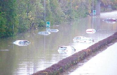
3 Great flood in the Netherlands History: Zeeland, 31 Jan casualties 2500 km2 flooded Evacuation of people Thousands of buildings destroyed


4 Vulnerability in Europe and worldwide EC assessment GVA (Delft Hydraulics)


5 ESA s Earth Observation Toolkit


6 ESA Storm Surge Project A new ESA Data User Element project AIM: To support storm surge systems, their services, engineers and scientists by facilitating the widespread user uptake and application of advanced information products from ESA and other Earth Observation missions. ERS, Topex/Poseidon derived M2 (left) & K1 (right) tidal amplitude (FES2004 model, CLS)


7 Timeline for esurge Project Project Start April 2011 for 30 months Phase 1: 12 months Generate Demonstration System with test events Phase 2: months Populate System and add live events METOP AVHRR TC Sidr Bangladesh ENVISAT ASAR Ganges Delta ENVISAT MERIS The River Plate GOCE GEOID unification of tide gauges ASCAT winds TC Nargis

8 esurge Consortium Leaders in Storm Surge forecasting Processing and use of EO data Outreach and web services


9 Key User Requirements To develop (based on mature and existing altimeter retracking systems), validate and provide dedicated coastal altimeter products. To develop, validate and, provide dedicated coastal products derived from SAR, passive microwave and optical satellite products. To provide and maintain an extensive historical archive of data products derived from satellite, in situ, model systems and socio-economic data for the purpose of improved storm surge modelling and re-analysis. To provide a near real time service of specific satellite products in support of storm surge forecasting and warning services. To encourage and assist (training, documentation, tools, services) the storm surge community to fully exploit the potential of satellite data for storm surge applications. To increase user uptake of coastal altimeter and other satellite data products by demonstrating their value in storm surge applications.
10 Objectives of the Project 1. Develop, demonstrate and validate advanced techniques for retrieving high-resolution information on TWLE, wind speed, and waves in the coastal zone. 2. Develop and provide validated coastal altimetry products for user defined Areas of Interest (AOI) 3. Provide access to general EO data products, NWP, NOP and other socio-economic data that characterise storm surge events in AOI 4. Develop an open-access database (the esurge Event Analysis and Repository Service: SEARS) of EO and other data for historical and contemporary storm Surge EVent (SEV) case studies for AOI 5. Provide a demonstration NRT service of EO data products and esurge services (esurge Live) in support of operational and experimental storm surge forecasting and warning services 6. Run a number of re-analysis data assimilation and validation experiments for historical and contemporary storm surge events and demonstrate the impact of EO data on storm surge applications 7. Provide dedicated training activities to encourage and assist the storm surge community to fully exploit the potential of satellite data for storm surge applications
11 User Service Requirements 1. Satellite data products processed in the coastal zone tuned to storm surge applications with uncertainty estimates 2. Standardisation of EO data for Storm Surges 3. Documentation of data and system tuned to Storm surge users 4. Easy access to EO data 5. Database of historical case studies over several areas of interest 6. NRT Service of EO data for operational systems 7. Tropical and Extra-Tropical Cyclone areas are both included 8. Build on existing capabilities develop only as required (e.g. ESA COASTALT, GlobWave projects) 9. Perform data assimilation experiments with the esurge system 10. Impact assessments of new data on storm surge models 11. Training and education tools for Users 12. Web portal as a central access point for all resources 13. Develop and maintain good international collaboration

12 Key Areas Of Interest (AOI) Some areas may only have limited data or data for limited number of SEV
13 Surge Events Within each AOI, Data will be collected for a series of Surge EVents (SEV) 50 Test Data sets 200+ Full Products Data Sets Selection Criteria Users (including esurge partner) interest Existence of, or planned, reanalysis experiments Application of operational agency criteria (eg events where a storm surge warning was issued)


14 Improving Access to Data esurge Users Web Portal Data access Data tools Visualization Training Handbooks Code EO Impact Assessment esurge-live! NRT service SEARS Case Studies of SEV in AOI Space Agencies Common Processing to agreed format(s) VIS/IR ALT SCAT NWP Flood Others Data Centres Data in in diverse formats and locations
15 Satellite Measurement Requirements Key measurement requirements for improved storm surge applications and services include: TWLE in coastal zone Storm track and intensity Nearshore wind fields Wave heights Surface water levels (at least 1-minute average values) Surface pressure fields, at least pressure drop Surface currents Sea surface temperature, vertical temperature profiles, sea surface height anomalies High resolution satellite images of inundated regions Satellite data: Satellite altimeter (winds, waves, water levels including a direct measurement of TWLE) Satellite scatterometer (wind) Satellite Synthetic Aperture Radar (winds and waves, swell, coastal inundation) Satellite passive microwave radiometers (winds, SST, sea ice) Satellite thermal infrared radiometers (SST, storm track) Satellite visible imagers (storm track, coastal inundation)
 Global compositing Wind")


16 Daily fields (SST, OC, SLA, Wind) Global compositing Wind SLA SST OC Routine daily merged high resolution products (L4) are becoming available from multi-satellite composite data.


17 Scatterometry Winds Seawinds on QuikSCAT 25 km by 25 km of spatial resolution swath about 1800 km wide Metop ASCAT 25 km by 25 km of spatial resolution Two swaths about 550 km wide with a gap of about 650 km courtesy: S Zecchetto (ESA Storm Surge Project-User consultation meeting, Venice September 2009)

18 ASCAT winds on MetOp Descending passes only 3 October 2011 OSI SAF ASCAT 25-km product viewer :30


19 ASCAT winds on MetOp Descending passes only 3 October 2011 OSI SAF ASCAT 12.5-km product viewer :30

20 ASCAT winds on MetOp


21 OSCAT Winds on Oceansat2 Oceansat-2 (ISRO) global Ku-band Scatterometer (OSCAT) data


22 Satellite Altimeter Measurements Katrina Courtesy R. Scharroo Altimetrics LLC
 Prototype retracking & Wet tropospheric processors available Ideally needs")
 generate")
23 Coastal Altimeter Data Measures TWLE!! Vignudelli et al (2010) Prototype retracking & Wet tropospheric processors available Ideally needs referencing to an orthometric height system together with in situ data Coastal Geophysical Data (CGDR) already developed Need to run the systems in a sustained manner New altimeters (Cryosat SIRAL) generate data ~300m along track (from November 2010->) AltiKa, Sentinel-3a & 3b JASON


24 GlobWave All satellite products already available in a CF-1.4 compliant NetCDF format esurge will act as an additional portal for a subset of GlobWave Wave Data Altimeter ERS-1, ERS-2, ENVISAT, TOPEX/POSEIDON, Jason-1, Jason-2, GEOSAT, GFO SAR ERS-1, ERS-2, ENVISAT Coastal Altimetry data generated within esurge can be served through the GlobWave portal


25 Visible/Infrared images Workhorse data for storm track monitoring especially from geostationary platform Sidr 2007
 Passive Microwave")
 SAR (ERS,")
 Optical data (MERIS, AATSR, AVHRR, SeaWiFs")

26 Example esurge Input Data Altimeter (ERS, ENVISAT, GEOSAT, TOPEX, JASON, CryoSAT) Passive Microwave (SSM/I, AMSRE, TMI, WindSat) Scatterometer (ERS, QuickScat, ASCAT, NSCAT, OceanSat-2 ) SAR (ERS, ENVISAT, RADARSAT, COSMO SkyMed, TerraSAR-X, RISAT ) Optical data (MERIS, AATSR, AVHRR, SeaWiFs Oceansat OCM-2 ) NWP and NOP model outputs Storm Surge model output and forcing Flood maps In situ measurements

27 ESA Data User Element The Data User Element (DUE) mission is to encourage the establishment of a long-term relationship between user communities and Earth Observation... DUE runs user driven projects to transfer research to applications DUE projects are run in close collaboration with users: User Requirements are defined prior to Invitation to Tender Letters of commitment from Champion Users Users involved as advisors during the project (annual user consultation workshop) Users assess the project results
 A number of Champion Users agreed to help guide the project, review the project outcomes and, advise ESA during")
28 Storm Surge User Consultation 42 people attended the meeting in Venice, Italy 2009 Supported by IOC and WMO 15 International countries represented including NL, UK, IE, NO, DK, IT, DE, FR, Canada, USA, Thailand, Puerto Rico, Australia, (with contributions from India and Mozambique) A number of Champion Users agreed to help guide the project, review the project outcomes and, advise ESA during the project Generated initial User Requirements
29 esurge Collaboration The esurge Contract demands international collaboration Local knowledge is required for effective Storm Surge management We want to link to active storm surge communities Exchange of ideas, models, experiences (operational and scientific) Identification of important AOI and SEV Testing of esurge products Participation in User Feedback, training and education etc

30
31 Thankyou For more information please contact: or
Coastal Inundation Forecasting Demonstration Project (CIFDP)
") WMO World Meteorological Organization Working together in weather, climate and water Coastal Inundation Forecasting Demonstration Project (CIFDP) Don Resio and Val Swail Co-Chairs, CIFDP Steering Group
WMO World Meteorological Organization Working together in weather, climate and water Coastal Inundation Forecasting Demonstration Project (CIFDP) Don Resio and Val Swail Co-Chairs, CIFDP Steering Group
Institute of Marine Sciences, National Research Council (ISMAR-CNR), Venice
, Venice") Overview of the esurge-venice project Marco Bajo Institute of Marine Sciences, National Research Council (ISMAR-CNR), Venice Istituto di Scienze Marine (ISMAR-CNR), National Research Council of Italy,
Overview of the esurge-venice project Marco Bajo Institute of Marine Sciences, National Research Council (ISMAR-CNR), Venice Istituto di Scienze Marine (ISMAR-CNR), National Research Council of Italy,
Project GlobWave. User Meeting 5 th -6 th October, Geoff Busswell, GlobWave Project Manager
 Project GlobWave User Meeting 5 th -6 th October, 2011 Geoff Busswell, GlobWave Project Manager www.globwave.info Partners ESA: Funding the project through its Data User Element Programme CNES: Providing
Ocean Vector Wind as Essential Climate Variable.
 Ocean Vector Wind as Essential Climate Variable Ad.Stoffelen@knmi.nl Context WCRP, World Climate Research Program WOAP, WCRP Observation Assimilation Panel GCOS, Global Climate Observing System Essential
Project GlobWave. GlobWave All rights reserved
 Project GlobWave GlobWave 2009. All rights reserved Agenda 1 2 3 4 5 6 7 8 9 10 11 12 Partners Objective Strategy Satellite Products Satellite vs In Situ Matchup Database Satellite vs Satellite Matchup
OSE/OSSEs at NOAA. Eric Bayler NOAA/NESDIS/STAR
 OSE/OSSEs at NOAA Eric Bayler NOAA/NESDIS/STAR OSE/OSSEs at NOAA NOAA Leadership view: Relatively inexpensive way to: Assess the impact of potential new observations Refine and redirect current observing
GEOSC/METEO 597K Kevin Bowley Kaitlin Walsh
 GEOSC/METEO 597K Kevin Bowley Kaitlin Walsh Timeline of Satellites ERS-1 (1991-2000) NSCAT (1996) Envisat (2002) RADARSAT (2007) Seasat (1978) TOPEX/Poseidon (1992-2005) QuikSCAT (1999) Jason-2 (2008)
HR-DDS and Pilot Wave Forecast Verification Scheme Extension. Interactive on-demand analysis David Poulter, National Oceanography Centre
 HR-DDS and Pilot Wave Forecast Verification Scheme Extension Interactive on-demand analysis David Poulter, National Oceanography Centre GlobWave 2010. All rights reserved The Globwave HR-DDS The GlobWave
AWDP km. 25 km
 MyOcean2 Wind AWDP 1 12.5 km 25 km Tropical variability 1. Dry areas reasonable 2. NWP models lack airsea interaction in rainy areas 3. ASCAT scatterometer does a good job near rain 4. QuikScat, OSCAT
Julia Figa-Saldaña & Klaus Scipal
 Julia Figa-Saldaña & Klaus Scipal julia.figa@eumetsat.int klaus.scipal@esa.int Meeting, Outline MetOp/EPS status MetOp/EPS Second Generation status 2016 scatterometer conference Other European ocean programme
Supplementary material to Challenges in Coastal Satellite Radar Altimetry
 Supplementary material to Challenges in Coastal Satellite Radar Altimetry Published 30 June 2009 Jérôme Benveniste, European Space Agency Center for Earth Observation (ESRIN), Frascati, Italy Stefano Vignudelli,
Improving global coastal inundation forecasting WMO Panel, UR2014, London, 2 July 2014
 Improving global coastal inundation forecasting WMO Panel, UR2014, London, 2 July 2014 Cyclone Sidr, November 2007 Hurricane Katrina, 2005 Prof. Kevin Horsburgh Head of marine physics, UK National Oceanography
The ESA Earth observation programmes overview and outlook
 The ESA Earth observation programmes overview and outlook Dr. Volker Liebig Director, ESA EO Programmes ILA 2008, Berlin ENVISAT mission: 6 years! Bam earthquake Tectonic uplift (Andaman) Arctic 2007 First
Climate data records from OSI SAF scatterometer winds. Anton Verhoef Jos de Kloe Jeroen Verspeek Jur Vogelzang Ad Stoffelen
 Climate data records from OSI SAF scatterometer winds Anton Verhoef Jos de Kloe Jeroen Verspeek Jur Vogelzang Ad Stoffelen Outline Motivation Planning Preparation and methods Quality Monitoring Output
Copernicus Marine Environment Monitoring Service
 Copernicus Marine Environment Monitoring Service Mercator Ocean March 2017 Implemented by Entrusted to Mercator Ocean by the European Commission Cliquez et modifiez le titre French non-profit company Owned
Operational systems for SST products. Prof. Chris Merchant University of Reading UK
 Operational systems for SST products Prof. Chris Merchant University of Reading UK Classic Images from ATSR The Gulf Stream ATSR-2 Image, ƛ = 3.7µm Review the steps to get SST using a physical retrieval
Update on SCOPE-Nowcasting Pilot Project Real Time Ocean Products Suman Goyal Scientist-E
 Update on SCOPE-Nowcasting Pilot Project Real Time Ocean Products Suman Goyal Scientist-E 19-22 Nov 2013 SCOPE-Nowcasting-1 Agenda Item 5 Pilot Projects Overview Users /Clients User requirements Product
Earth Observation in coastal zone MetOcean design criteria
 ESA Oil & Gas Workshop 2010 Earth Observation in coastal zone MetOcean design criteria Cees de Valk BMT ARGOSS Wind, wave and current design criteria geophysical process uncertainty modelling assumptions
Remote sensing of sea ice
 Remote sensing of sea ice Ice concentration/extent Age/type Drift Melting Thickness Christian Haas Remote Sensing Methods Passive: senses shortwave (visible), thermal (infrared) or microwave radiation
Blended Sea Surface Winds Product
 1. Intent of this Document and POC Blended Sea Surface Winds Product 1a. Intent This document is intended for users who wish to compare satellite derived observations with climate model output in the context
TERMS OF REFERENCE FOR THE CEOS OCEAN SURFACE VECTOR WINDS VIRTUAL CONSTELLATION VERSION 1.0 LAST UPDATED: 19 DECEMBER 2013
 TERMS OF REFERENCE FOR THE CEOS OCEAN SURFACE VECTOR WINDS VIRTUAL CONSTELLATION VERSION 1.0 LAST UPDATED: 19 DECEMBER 2013 CONSTELLATION NAME: Ocean Surface Vector Winds Virtual Constellation (OSVW- VC)
STATUS ON THE USE OF SCATTEROMETER DATA AT METEO FRANCE
 STATUS ON THE USE OF SCATTEROMETER DATA AT METEO FRANCE Christophe Payan Centre National de Recherches Météorologiques, M CNRS-GAME CNRS and Météo-France Toulouse, France 9th International Winds Workshop,
EUMETSAT SAF Wind Services
 EUMETSAT SAF Wind Services Ad Stoffelen Marcos Portabella (CMIMA) Anton Verhoef Jeroen Verspeek Jur Vogelzang Maria Belmonte scat@knmi.nl Status SAF activities NWP SAF software AWDP1. beta tested; being
CopernicusEU. the EU's Earth Observation Programme. Sara Zennaro Atre Delegation of the European Union to Japan
 Copernicus the EU's Earth Observation Programme Sara Zennaro Atre Delegation of the European Union to Japan Status Overview, Sept 2016 & Ocean Policies Seminar 4 October 2016 ollow us on: Copernicus EU
Satellite ALTimetry. SALT applications and use of data base for SE-Asia region. SEAMERGES kick-off meeting, Bangkok, Thailand.
 Satellite ALTimetry SALT applications and use of data base for SE-Asia region SEAMERGES kick-off meeting, Bangkok, Thailand Marc Naeije 4 March 2004 1 Faculty of Aerospace Engineering DEOS/AS SEAMERGES
STARS-DAT v2. User Manual
 STARS-DAT v2 User Manual Version 2.1 March 2011 Steinar Eastwood and Magnus Drivdal Norwegian Meteorological Institute Documentation Change Record Document version Date Description v 0.1 25-05-2010 First
P. Cipollini, H. Snaith - A short course on Altimetry. Altimetry 2 - Data processing (from satellite height to sea surface height)
") P. Cipollini, H. Snaith - A short course on Altimetry Altimetry 2 - Data processing (from satellite height to sea surface height) 1 2 Satellite height to sea surface height The altimeter measures the altitude
P. Cipollini, H. Snaith - A short course on Altimetry Altimetry 2 - Data processing (from satellite height to sea surface height) 1 2 Satellite height to sea surface height The altimeter measures the altitude
Arctic Regional Ocean Observing System Arctic ROOS Report from 2012
 Arctic Regional Ocean Observing System Arctic ROOS Report from 2012 By Stein Sandven Nansen Environmental and Remote Sensing Center (www.arctic-roos.org) Focus in 2012 1. Arctic Marine Forecasting Center
SSH retrieval in the ice covered Arctic Ocean: from waveform classification to regional sea level maps
 ESA Climate Change Initiative SSH retrieval in the ice covered Arctic Ocean: from waveform classification to regional sea level maps CLS LEGOS PML Arctic SIE status 2 nd lowest on record with 4.14 10 6
A state of the art and user driven Copernicus service Physics and Biogeochemistry
 C M E M S P r e s e n t a n d F u t u r e R e q u i r e m e n t s f o r I n - S i t u a n d S a t e l l i t e O b s e r v a t i o n s Antonio REPPUCCI; Pierre Yves LE TRAON Mercator Ocean International
EUMETSAT SAF NETWORK. Lothar Schüller, EUMETSAT SAF Network Manager
 1 EUMETSAT SAF NETWORK Lothar Schüller, EUMETSAT SAF Network Manager EUMETSAT ground segment overview METEOSAT JASON-2 INITIAL JOINT POLAR SYSTEM METOP NOAA SATELLITES CONTROL AND DATA ACQUISITION FLIGHT
Assimilation of Scatterometer Winds at ECMWF
 Assimilation of Scatterometer Winds at Giovanna De Chiara, Peter Janssen Outline ASCAT winds monitoring and diagnostics OCEANSAT-2 winds Results from the NWP winds impact study Slide 1 Scatterometer data
Coastal Altimetry: recent developments and proposed use in the Agulhas region. Paolo Cipollini (NOCS, UK)
") Coastal Altimetry: recent developments and proposed use in the Agulhas region Paolo Cipollini (NOCS, UK) Coastal altimetry - the concept Satellite altimetry has been designed for the open ocean 15 years
Coastal Altimetry: recent developments and proposed use in the Agulhas region Paolo Cipollini (NOCS, UK) Coastal altimetry - the concept Satellite altimetry has been designed for the open ocean 15 years
ESA Climate Change Initiative (CCI)
") ESA Climate Change Initiative (CCI) New ESA Programme with the aim to contribute to worldwide efforts to generate Essential Climate Variables (ECVs) C. Zehner Barcelona, 07/09/2009 Two climate action paths
ESA Climate Change Initiative (CCI) New ESA Programme with the aim to contribute to worldwide efforts to generate Essential Climate Variables (ECVs) C. Zehner Barcelona, 07/09/2009 Two climate action paths
Coastal Altimetry Data Handbook Issue 2.0, 02 September 2014
 Coastal Altimetry Data Handbook Issue 2.0, 02 September 2014 Edited by the Coastal & Marine Research Centre, University College Cork DOCUMENT DETAILS Author Paolo Cipollini, Rory Scarrott, Helen Snaith
"Outcomes of the storm surge and waves workshop in Dominican Republic and the questionnaire"
 "Outcomes of the storm surge and waves workshop in Dominican Republic and the questionnaire" Strengthening Regional Cooperation to Support Forecasting with Multi Hazard Approach in RA IV Ritz Carlton Grand
The contribution of Coastal Altimetry to Mediterranean Sea Level Research
 The contribution of Coastal Altimetry to Mediterranean Sea Level Research (with some ideas for discussion) Paolo Cipollini 1, and the COASTALT Partners 1 National Oceanography Centre, UK presented by Mikis
Permafrost: Earth Observation Applications: Introduction
 Polar Meeting 3 Permafrost: Earth Observation Applications: Introduction Mark Drinkwater CNES, Paris, 22 23 May, 2013 Remote Sensing of Permafrost which Remote Sensing products? applicability to Permafrost
Satellite Oceanography and Applications 2: Altimetry, scatterometry, SAR, GRACE. RMU Summer Program (AUGUST 24-28, 2015)
") Satellite Oceanography and Applications 2: Altimetry, scatterometry, SAR, GRACE RMU Summer Program (AUGUST 24-28, 2015) Altimetry 2 Basic principles of satellite altimetry Altimetry: the measurements of
Satellite Oceanography and Applications 2: Altimetry, scatterometry, SAR, GRACE RMU Summer Program (AUGUST 24-28, 2015) Altimetry 2 Basic principles of satellite altimetry Altimetry: the measurements of
Preliminary Programme (090910)
") Preliminary Programme (090910) Day 1, Thursday 17 September 2009 08:00 08:30 Registration and Poster Mounting 08:30 08:50 Introduction and Objectives of the Workshop J. Benveniste, P. Cipollini, L. Miller,
Preliminary Programme (090910) Day 1, Thursday 17 September 2009 08:00 08:30 Registration and Poster Mounting 08:30 08:50 Introduction and Objectives of the Workshop J. Benveniste, P. Cipollini, L. Miller,
Geoscience Australia Report on Cal/Val Activities
 Medhavy Thankappan Geoscience Australia Agency Report I Berlin May 6-8, 2015 Outline 1. Calibration / validation at Geoscience Australia Corner reflector infrastructure for SAR calibration (for information)
TIDE GAUGE AND SATELLITE ALTIMETRY INTEGRATION FOR STORM SURGE PREDICTION
 TIDE GAUGE AND SATELLITE ALTIMETRY INTEGRATION FOR STORM SURGE PREDICTION Ole B. Andersen 1, Y. Cheng 1, X. Deng 2, M. Steward 2 and Z. Gharinerat 2 (1) DTU Space, Elektrovej bldg. 328 Lyngny, Denmark
CryoSat: ESA s Ice Mission:
 CryoSat: ESA s Ice Mission: 6 years in operations: status and achievements T. Parrinello CryoSat Mission Manager M. Drinkwater Mission Scientist CryoSat March 2016 sea-ice thickness CryoSat: A bit of history
Annex VI-1. Draft National Report on Ocean Remote Sensing in China. (Reviewed by the Second Meeting of NOWPAP WG4)
") UNEP/NOWPAP/CEARAC/WG4 2/9 Page1 Draft National Report on Ocean Remote Sensing in China (Reviewed by the Second Meeting of NOWPAP WG4) UNEP/NOWPAP/CEARAC/WG4 2/9 Page1 1. Status of RS utilization in marine
UNEP/NOWPAP/CEARAC/WG4 2/9 Page1 Draft National Report on Ocean Remote Sensing in China (Reviewed by the Second Meeting of NOWPAP WG4) UNEP/NOWPAP/CEARAC/WG4 2/9 Page1 1. Status of RS utilization in marine
Geophysical Correction Application in Level 2 CryoSat Data Products
 ESRIN-EOP-GQ / IDEAS IDEAS-VEG-IPF-MEM-1288 Version 2.0 29 July 2014 Geophysical Correction Application in Level 2 CryoSat Data Products TABLE OF CONTENTS 1 INTRODUCTION... 3 1.1 Purpose and Scope... 3
Tide Gauge Data Handbook Issue 1.0, 22 January 2013
 Tide Gauge Data Handbook Issue 1.0, 22 January 2013 Edited by the Coastal & Marine Research Centre, University College Cork DOCUMENT DETAILS Authors Vibeke Huess, Rory Scarrott Document Title Product Data
STARS-DAT v3. User Manual
 STARS-DAT v3 User Manual Version 3.1 December 2012 Steinar Eastwood, Yvonne Gusdal, Magnus Drivdal, Birgitte Furevik, Harald Schyberg and Frank Thomas Tveter Norwegian Meteorological Institute Documentation
JCOMM-CHy Coastal Inundation Forecasting Demonstration Project (CIFDP)
") WMO World Meteorological Organization Working together in weather, climate and water JCOMM-CHy Coastal Inundation Forecasting Demonstration Project (CIFDP) Coastal Flooding & Vulnerable Populations Coastal
WMO World Meteorological Organization Working together in weather, climate and water JCOMM-CHy Coastal Inundation Forecasting Demonstration Project (CIFDP) Coastal Flooding & Vulnerable Populations Coastal
Coastal Inundation Forecasting Demonstration Project CIFDP. Flood Forecasting Initiative-Advisory Group (FFI-AG 3), Geneva, 5-7 Dec, 2017
, Geneva, 5-7 Dec, 2017") Coastal Inundation Forecasting Demonstration Project CIFDP Flood Forecasting Initiative-Advisory Group (FFI-AG 3), Geneva, 5-7 Dec, 2017 Coastal Flooding & Vulnerable Populations Coastal populations are
Coastal Inundation Forecasting Demonstration Project CIFDP Flood Forecasting Initiative-Advisory Group (FFI-AG 3), Geneva, 5-7 Dec, 2017 Coastal Flooding & Vulnerable Populations Coastal populations are
EUMETSAT SAF NETWORK. Lothar Schüller, EUMETSAT SAF Network Manager
 1 EUMETSAT SAF NETWORK Lothar Schüller, EUMETSAT SAF Network Manager EUMETSAT ground segment overview METEOSAT JASON-2 INITIAL JOINT POLAR SYSTEM METOP NOAA SATELLITES CONTROL AND DATA ACQUISITION FLIGHT
Programmatic Perspectives
 NOAA Programmatic Perspectives Stan Wilson NOAA Satellite & Information Service IOVW Science Team Meeting, Annapolis, 9-11 May 2011 1 NOAA Plans Beyond QuikSCAT NOAA has been pursuing two avenues to meet
Status of Indian Satellite Meteorological Programme
 Status of Indian Satellite Meteorological Programme Pradeep K Thapliyal Space Applications Centre (SAC) Indian Space research Organisation (ISRO) Ahmedabad (INDIA) Email: pkthapliyal@sac.isro.gov.in International
URSI-F Microwave Signatures Meeting 2010, Florence, Italy, October 4 8, Thomas Meissner Lucrezia Ricciardulli Frank Wentz
 URSI-F Microwave Signatures Meeting 2010, Florence, Italy, October 4 8, 2010 Wind Measurements from Active and Passive Microwave Sensors High Winds and Winds in Rain Thomas Meissner Lucrezia Ricciardulli
ASCAT NRT Data Processing and Distribution at NOAA/NESDIS
 ASCAT NRT Data Processing and Distribution at NOAA/NESDIS Paul S. Chang, Zorana Jelenak, Seubson Soisuvarn, Qi Zhu Gene Legg and Jeff Augenbaum National Oceanic and Atmospheric Administration (NOAA) National
Polar Space Task Group Space Agency Report
 Polar Agency Report EUMETSAT WMO HQ, Geneva 16-18 October, 2018 EUMETSAT News EPS OSI SAF products Sentinel-3 PSTG8 Meeting, WMO, 16-18 Oct., 2018 EUMETSAT Polar System: Metop- C Launch Preparation Metop-C
CGMS Baseline. Sustained contributions to the Global Observing System. Endorsed by CGMS-46 in Bengaluru, June 2018
 CGMS Baseline Sustained contributions to the Global Observing System Best Practices for Achieving User Readiness for New Meteorological Satellites Endorsed by CGMS-46 in Bengaluru, June 2018 CGMS/DOC/18/1028862,
CGMS Baseline In response to CGMS action/recommendation A45.01 HLPP reference: 1.1.8
 Prepared by WGIII Agenda Item: 7.1 Discussed in WGIII CGMS Baseline In response to CGMS action/recommendation A45.01 HLPP reference: 1.1.8 In CGMS-45, Working Group III agreed to hold a review of the CGMS
Current status of the remote sensing ocean observing system
 Current status of the remote sensing ocean observing system Pierre-Yves Le Traon Ifremer & Mercator ocean with contributions from G. Dibarboure, Y. Faugere, M.H. Rio, B. Chapron, J. Johannessen, L. Santolieri,
IMPORTANCE OF SATELLITE DATA (FOR REANALYSIS AND BEYOND) Jörg Schulz EUMETSAT
 Jörg Schulz EUMETSAT") IMPORTANCE OF SATELLITE DATA (FOR REANALYSIS AND BEYOND) Jörg Schulz EUMETSAT Why satellite data for climate monitoring? Global coverage Global consistency, sometimes also temporal consistency High spatial
IMPORTANCE OF SATELLITE DATA (FOR REANALYSIS AND BEYOND) Jörg Schulz EUMETSAT Why satellite data for climate monitoring? Global coverage Global consistency, sometimes also temporal consistency High spatial
UN COPUOS 52 nd session of the Scientific and Technical Subcommittee. COPERNICUS - an European Achievement. S. Jutz Head, ESA Copernicus Space Office
 UN COPUOS 52 nd session of the Scientific and Technical Subcommittee COPERNICUS - an European Achievement S. Jutz Head, ESA Copernicus Space Office 11 Feb 2015, Vienna 1 2 What is Copernicus? European
Earth Exploration-Satellite Service (EESS)- Active Spaceborne Remote Sensing and Operations
- Active Spaceborne Remote Sensing and Operations") Earth Exploration-Satellite Service (EESS)- Active Spaceborne Remote Sensing and Operations SRTM Radarsat JASON Seawinds TRMM Cloudsat Bryan Huneycutt (USA) Charles Wende (USA) WMO, Geneva, Switzerland
Earth Exploration-Satellite Service (EESS)- Active Spaceborne Remote Sensing and Operations SRTM Radarsat JASON Seawinds TRMM Cloudsat Bryan Huneycutt (USA) Charles Wende (USA) WMO, Geneva, Switzerland
EONav Satellite data in support of maritime route optimization
 EONav Satellite data in support of maritime route optimization Leif Eriksson Department of Space, Earth and Environment Chalmers University of Technology Outline Why is maritime navigation support needed?
Hindcast Arabian Gulf
 Hindcast Arabian Gulf Image of isobars of atmospheric pressure and hindcast wind- and wave field over the Arabian Gulf during a storm in January 1993. Detailed wave studies are supported by nesting of
JCOMM Status & Ocean-Observing Satellite Elements"
 JCOMM Status & Ocean-Observing Satellite Elements" Jean-Louis FELLOUS (ESA/CNES)! Co-president, JCOMM! CEOS Executive Secretary!! Eric Lindstrom (NASA)! The WMO-IOC Joint Technical Commission for Oceanography
PREDICTION AND MONITORING OF OCEANIC DISASTERS USING MICROWAVE REMOTE SENSING TECHNIQUES
 PREDICTION AND MONITORING OF OCEANIC DISASTERS USING MICROWAVE REMOTE SENSING TECHNIQUES O P N Calla International Centre for Radio Science, OM NIWAS A-23, Shastri Nagar, Jodhpur-342 003 Abstract The disasters
The COASTALT Project: Towards an Operational use of Satellite Altimetry in the Coastal Zone
 The COASTALT Project: Towards an Operational use of Satellite Altimetry in the Coastal Zone Stefano Vignudelli (1), Paolo Cipollini (2), Christine Gommenginger (2), Helen Snaith (2), Henrique Coelho (3),
Detection, tracking and study of polar lows from satellites Leonid P. Bobylev
 Detection, tracking and study of polar lows from satellites Leonid P. Bobylev Nansen Centre, St. Petersburg, Russia Nansen Centre, Bergen, Norway Polar lows and their general characteristics International
CEOS and Climate monitoring
 CEOS and Climate monitoring Committee on Earth Observation Satellites www.ceos.org Climate challenges and the need for observations Observations play a crucial role in the detection of climate change and
The role of GPS-RO at ECMWF" ! COSMIC Data Users Workshop!! 30 September 2014! !!! ECMWF
 The role of GPS-RO at ECMWF"!!!! COSMIC Data Users Workshop!! 30 September 2014! ECMWF WE ARE Intergovernmental organisation! 34 Member and Cooperating European states! 270 staff at ECMWF, in Reading,
GAP ANALYSIS FOR SATELLITE MISSIONS SUPPORTING THE GOS
 WMO OMM World Meteorological Organization Working together in weather, climate and water GAP ANALYSIS FOR SATELLITE MISSIONS SUPPORTING THE GOS CGMS-39 WMO-WP-31, Agenda item III.5 Dr B. Bizzarri, Consultant
OCEAN SURFACE DRIFT BY WAVELET TRACKING USING ERS-2 AND ENVISAT SAR IMAGES
 OCEAN SURFACE DRIFT BY WAVELET TRACKING USING ERS-2 AND ENVISAT SAR IMAGES Antony K. Liu, Yunhe Zhao Ocean Sciences Branch, NASA Goddard Space Flight Center, Greenbelt, Maryland, USA Ming-Kuang Hsu Northern
Copernicus Today and Tomorrow GEO Week Group on Earth Observation Geneva, 16 January 2014 The Copernicus Space Infrastructure
 Copernicus Today and Tomorrow GEO Week Group on Earth Observation Geneva, 16 January 2014 The Copernicus Space Infrastructure Thomas Beer, Policy Coordinator, Copernicus Space Office, ESA-ESRIN, Frascati
Ocean currents from altimetry
 Ocean currents from altimetry Pierre-Yves LE TRAON - CLS - Space Oceanography Division Gamble Workshop - Stavanger,, May 2003 Introduction Today: information mainly comes from in situ measurements ocean
EUMETSAT STATUS AND PLANS
 1 EUM/TSS/VWG/15/826793 07/10/2015 EUMETSAT STATUS AND PLANS François Montagner, Marine Applications Manager, EUMETSAT WMO Polar Space Task Group 5 5-7 October 2015, DLR, Oberpfaffenhofen PSTG Strategic
Forthcoming changes in the Global Satellite Observing Systems
 Forthcoming changes in the Global Satellite Observing Systems Mitchell D. Goldberg NOAA/NESDIS/JPSS Mitch.Goldberg@noaa.gov ABSTRACT This paper provides an overview of the key observations used for numerical
Satellite Application Facility on Ocean and Sea Ice (OSI SAF) Cécile Hernandez Plouzané, 20 June 2017
 Cécile Hernandez Plouzané, 20 June 2017") Satellite Application Facility on Ocean and Sea Ice (OSI SAF) Cécile Hernandez Plouzané, 20 June 2017 About OSI SAF EUMETSAT SAFs : dedicated centres of excellence for processing satellite data OSI SAF
Satellite Application Facility on Ocean and Sea Ice (OSI SAF) Cécile Hernandez Plouzané, 20 June 2017 About OSI SAF EUMETSAT SAFs : dedicated centres of excellence for processing satellite data OSI SAF
Ocean Vector Wind Constellation:
 The CEOS Ocean Vector Wind Constellation: Current Status and Challenges Stan Wilson, NOAA; Hans Bonekamp, EUMETSAT; and B.S. Gohil, ISRO Co Chairs International OVW Science Team Meeting Barcelona 18 20
Inter-tropical Convergence Zone (ITCZ) analysis using AIRWAVE retrievals of TCWV from (A)ATSR series and potential extension of AIRWAVE to SLSTR
 analysis using AIRWAVE retrievals of TCWV from (A)ATSR series and potential extension of AIRWAVE to SLSTR") Inter-tropical Convergence Zone (ITCZ) analysis using AIRWAVE retrievals of TCWV from (A)ATSR series and potential extension of AIRWAVE to SLSTR Enzo Papandrea (SERCO, CNR-ISAC, Enzo.Papandrea@serco.com)
Inter-tropical Convergence Zone (ITCZ) analysis using AIRWAVE retrievals of TCWV from (A)ATSR series and potential extension of AIRWAVE to SLSTR Enzo Papandrea (SERCO, CNR-ISAC, Enzo.Papandrea@serco.com)
Sea Level Space Watch: Service Offering
 Space for Smarter Government Programme Sea Level Space Watch: Service Offering General Sea Level Space Watch : Operational service developed to support national flood defence planning. Systematically updated
DLR s TerraSAR-X contributes to international fleet of radar satellites to map the Arctic and Antarctica
 DLR s TerraSAR-X contributes to international fleet of radar satellites to map the Arctic and Antarctica The polar regions play an important role in the Earth system. The snow and ice covered ocean and
Sea level changes around Thailand
 Final symposium 27 May Bangkok, Thailand Sea level changes around Thailand Marc Naeije Contents GEO2TECDI- SONG: measuring sea level around Thailand Concept of satellite altimetry Concept of tide gauges
Coastal Inundation Forecasting Demonstration Project (CIFDP)
") WMO World Meteorological Organization Working together in weather, climate and water Coastal Inundation Forecasting Demonstration Project (CIFDP) WMO Technical Commission for Oceanography and Marine Meteorology
WMO World Meteorological Organization Working together in weather, climate and water Coastal Inundation Forecasting Demonstration Project (CIFDP) WMO Technical Commission for Oceanography and Marine Meteorology
DERIVATION OF SEA LEVEL ANOMALY USING SATELLITE ALTIMETER. Ami Hassan Md Din, Kamaludin Mohd Omar
 DERIVATION OF SEA LEVEL ANOMALY USING SATELLITE ALTIMETER Ami Hassan Md Din, Kamaludin Mohd Omar Faculty of Geoinformation Science and Engineering Universiti Teknologi Malaysia Skudai, Johor E-mail: amihassan@utm.my
D2.1 Product Validation Plan (PVP)
") Consortium Members ESA Sea Level CCI D2.1 Product Validation Plan (PVP) Reference: Nomenclature: CLS-DOS-NT-10-278 SLCCI-PVP-005 Issue: 1. 1 Date: Oct. 11, 11 CLS-DOS-NT-10-278 SLCCI-PVP-005 Issue 1.1
Consortium Members ESA Sea Level CCI D2.1 Product Validation Plan (PVP) Reference: Nomenclature: CLS-DOS-NT-10-278 SLCCI-PVP-005 Issue: 1. 1 Date: Oct. 11, 11 CLS-DOS-NT-10-278 SLCCI-PVP-005 Issue 1.1
Use and Feedback on GlobWave Data and Services Perspective of basic studies
 Use and Feedback on GlobWave Data and Services Perspective of basic studies Sergei I. Badulin P.P. Shirshov Institute of Oceanology of Russian Academy of Science http://www.ocean.ru/eng/ bookmark us P.P.SHIRSHOV
River and Lake Level data from Radar Altimetry in Support of the Tiger Initiative
 River and Lake Level data from Radar Altimetry in Support of the Tiger Initiative Benveniste, J. (1) ; Berry, P. (2) ; Milagro-Perez, M.P. (3) ; Serpe, D. (3) (1) European Space Agency ESRIN, Via Galileo
Coastal Inundation Forecasting and Community Response in Bangladesh
 WMO Coastal Inundation Forecasting and Community Response in Bangladesh Bapon (SHM) Fakhruddin Nadao Kohno 12 November 2015 System Design for Coastal Inundation Forecasting CIFDP-PSG-5, 14-16 May 2014,
High resolution geoid from altimetry & bathymetry: requirements for a future mission
 High resolution geoid from altimetry & bathymetry: requirements for a future mission The GRAL team: J-Y Royer 1,2, M-F Lalancette 3, G Louis 1,2, M Maia 1,2, D Rouxel 3 & L Géli 4 Project funded by 1 2
Space for the Arctic
 Space for the Arctic Bo Andersen Norwegian Polar Committee & Norwegian Space Centre 1 My Mantra for Space Few, if any of the global challenges can be resolved by space alone But Few, if any can be resolved
OSTST Proposed splinters
 1. Proposed splinters OSTST 2018 This list will be used for the splinter selection in the abstract submission process Application development for Operations Instrument Processing 1. Instrument Processing:
Question 1: Do you have any comments on our approach to this review?:
 Question 1: Do you have any comments on our approach to this review?: No. Question 2: Do you have any comments on our broad overview of the satellite sector set out in this section? In particular, do you
EVALUATION OF WINDSAT SURFACE WIND DATA AND ITS IMPACT ON OCEAN SURFACE WIND ANALYSES AND NUMERICAL WEATHER PREDICTION
 5.8 EVALUATION OF WINDSAT SURFACE WIND DATA AND ITS IMPACT ON OCEAN SURFACE WIND ANALYSES AND NUMERICAL WEATHER PREDICTION Robert Atlas* NOAA/Atlantic Oceanographic and Meteorological Laboratory, Miami,
OPERATIONAL WAVE FORECASTING FOR TROPICAL CYCLONES CONDITIONS
 OPERATIONAL WAVE FORECASTING FOR TROPICAL CYCLONES CONDITIONS Jean-Michel Lefèvre 1, Lotfi Aouf 1, Pierre Queffeulou 2, Abderrahim Bentamy 2, Yves Quilfen 2 1 Meteo-France, Toulouse, France 2 IFREMER,
EO Information Services in support of West Africa Coastal vulnerability Service 2 : Sea Level Height & currents. Vinca Rosmorduc, CLS
 EO Information Services in support of West Africa Coastal vulnerability Service 2 : Sea Level Height & currents Vinca Rosmorduc, CLS World Bank HQ, Washington DC Date : 23 February 2012 West Africa coastal
ASCAT-B Level 2 Soil Moisture Validation Report
 EUMETSAT EUMETSAT Allee 1, D-64295 Darmstadt, Doc.No. : EUM/OPS/DOC/12/3849 Germany Tel: +49 6151 807-7 Issue : v2 Fax: +49 6151 807 555 Date : 20 December 2012 http://www.eumetsat.int Page 1 of 25 This
Digital Elevation Model (DEM) Data Handbook Issue 2.0, 04 November 2013
 Data Handbook Issue 2.0, 04 November 2013") Digital Elevation Model (DEM) Data Handbook Issue 2.0, 04 November 2013 Edited by the Coastal & Marine Research Centre, University College Cork DOCUMENT DETAILS Author Document Title Document Reference
Digital Elevation Model (DEM) Data Handbook Issue 2.0, 04 November 2013 Edited by the Coastal & Marine Research Centre, University College Cork DOCUMENT DETAILS Author Document Title Document Reference
Validation Report: WP5000 Regional tidal correction (Noveltis)
") Consortium Members ESA Cryosat Plus for Oceans Validation Report: WP5000 Regional tidal correction (Noveltis) Reference: Nomenclature: CLS-DOS-NT-14-083 CP4O-WP5000-VR-03 Issue: 2. 0 Date: Jun. 20, 14
Consortium Members ESA Cryosat Plus for Oceans Validation Report: WP5000 Regional tidal correction (Noveltis) Reference: Nomenclature: CLS-DOS-NT-14-083 CP4O-WP5000-VR-03 Issue: 2. 0 Date: Jun. 20, 14
Using satellite altimetry and tide gauges for storm surge warning
 doi:10.5194/piahs-365-28-2015 28 Complex Interfaces Under Change: Sea River Groundwater Lake Proceedings of HP2/HP3, IAHS-IAPSO-IASPEI Assembly, Gothenburg, Sweden, July 2013 (IAHS Publ. 365, 2014). Using
Scatterometer winds.
 Scatterometer winds Ad.Stoffelen@KNMI.nl Manager NWP SAF at KNMI Manager OSI SAF at KNMI PI European OSCAT Cal/Val project Leader KNMI Satellite Winds Group www.knmi.nl/scatterometer scat@knmi.nl Overview