Earth Observation in coastal zone MetOcean design criteria
|
|
|
- Victoria Nelson
- 5 years ago
- Views:
Transcription


1 ESA Oil & Gas Workshop 2010 Earth Observation in coastal zone MetOcean design criteria Cees de Valk BMT ARGOSS
2 Wind, wave and current design criteria geophysical process uncertainty modelling assumptions approximation errors (weather, wave) sampling bias hindcast data (weather, wave) sampling variability tail distribution assumptions model unc. & estimator measurement errors sampling variability model uncertainty observations (weather, waves) wave database sampling variability metocean conditions over time interval climate uncertainty climate (ensemble) F Fˆ

, tidal modelling Data assimilation (merging measurement data into model")

3 Exploiting developments in measuring, predicting and reconstructing weather and ocean Global satellite measurement of weather and sea surface wind scatterometer, radar altimeter, SAR Computer modelling Numerical weather prediction Sea surface wave prediction GCM s (Global Circulation Models: Ocean + atmosphere), tidal modelling Data assimilation (merging measurement data into model predictions) to analyse (hindcast) the past To forecast the future Verification Using satellite data, prediction can be verified globally Simultaneous data from independent sources allow assessment of uncertainty


4 Global Tidal Elevation and Tidal Current Data Characteristics: Based on integration of tide gauge data from stations and over 20 years of satellite measurements with numerical modelling Global coverage, varying resolution Information at resolutions of up to 1 minute readily available near coast Even finer resolutions possible through dedicated modelling
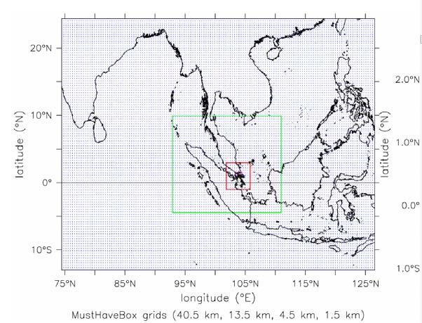
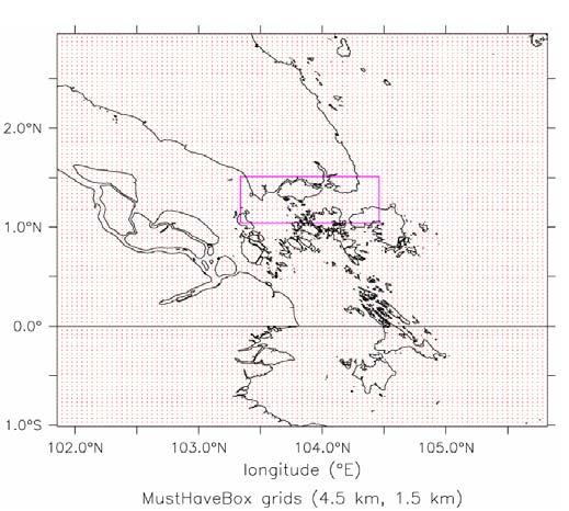
5 High Resolution Weather Prediction Zooming in step by step

6 Nearshore and shallow-water wave hindcasting Delaware Bay nearshore wave transformation test: bathymetry and gridpoints of global hindcast model
7 Nearshore and shallow-water wave hindcasting Example: spectral wave ray tracing model, rays to boundary
 and buoy")
8 Nearshore and shallow-water wave hindcasting Probability distribution of Hs per month: hindcast (left) and buoy (right)
9 Data quality control and data uncertainty assessment Precision measurement using coinciding data from 3 sources


10 Satellite wind and wave data in quality control and data uncertainty assessment
11 Data quality control and data uncertainty assessment Precision measurement using coinciding data from 3 sources
12 Wind, wave and current design criteria

13 Data quality control and data uncertainty assessment Data quality information made accessible from everywhere over the Web


14 Data quality control and data uncertainty assessment Data quality information made accessible from everywhere over the Web
15 Data quality control and data uncertainty assessment Data quality information made accessible from everywhere over the Web

16 Data quality control and data uncertainty assessment Relative root-mean-square error of altimeter minus original/calibrated model wave height. Data quality information made accessible from everywhere over the Web
17 Data quality control and data uncertainty assessment Data quality information made accessible from everywhere over the Web

18 Data quality control and data uncertainty assessment Bias of altimeter minus original /calibrated model wave height Data quality information made accessible from everywhere over the Web

19 Data quality control and data uncertainty assessment Standard deviation of altimeter minus original /calibrated model wave height Data quality information made accessible from everywhere over the Web
20 Data quality control and data uncertainty assessment The main limitation of altimeter data for wave hindcast calibration is data volume: the Hs range where storm hindcasts get biased is not sufficiently covered

21 SAR Imagery: coastal wind fields

22 SAR Imagery: coastal wind fields

23 SAR Imagery: coastal wind fields

24 SAR Imagery: internal waves

25 Imagery: coastal sea-surface waves Hi Res optical image of SW coast of Bali (Digital Globe)

26 Imagery: coastal sea-surface waves Crude wave phase picture from Bali image


27 Thank You
The MSC Beaufort Wind and Wave Reanalysis
 The MSC Beaufort Wind and Wave Reanalysis Val Swail Environment Canada Vincent Cardone, Brian Callahan, Mike Ferguson, Dan Gummer and Andrew Cox Oceanweather Inc. Cos Cob, CT, USA Introduction: History
Hindcast Arabian Gulf
 Hindcast Arabian Gulf Image of isobars of atmospheric pressure and hindcast wind- and wave field over the Arabian Gulf during a storm in January 1993. Detailed wave studies are supported by nesting of
Modeling the North West European Shelf using Delft3D Flexible Mesh
 Modeling the North West European Shelf using Delft3D Flexible Mesh 2nd JCOMM Scientific and Technical Symposium on Storm Surges, 8-13 Nov. 2015, Key West, USA; Firmijn Zijl Outline of this presentation
New developments in data assimilation in MIKE 21/3 FM Assimilation of along-track altimetry data with correlated measurement errors
 New developments in data assimilation in MIKE 21/3 FM Assimilation of along-track altimetry data with correlated measurement errors EnKF Workshop 2016-06-20 Jesper Sandvig Mariegaard Henrik Andersson DHI
CFSR surface wind calibration for wave modelling purposes
 13 th International Workshop on Wave Hindcasting and Forecasting CFSR surface wind calibration for wave modelling purposes Sander Hulst [1], Gerbrant Ph. van Vledder [1,2] [1] BMT ARGOSS, Marknesse, Netherlands
HY-2A Satellite User s Guide
 National Satellite Ocean Application Service 2013-5-16 Document Change Record Revision Date Changed Pages/Paragraphs Edit Description i Contents 1 Introduction to HY-2 Satellite... 1 2 HY-2 satellite data
Observations of Arctic snow and sea ice thickness from satellite and airborne surveys. Nathan Kurtz NASA Goddard Space Flight Center
 Observations of Arctic snow and sea ice thickness from satellite and airborne surveys Nathan Kurtz NASA Goddard Space Flight Center Decline in Arctic sea ice thickness and volume Kwok et al. (2009) Submarine
Satellite ALTimetry. SALT applications and use of data base for SE-Asia region. SEAMERGES kick-off meeting, Bangkok, Thailand.
 Satellite ALTimetry SALT applications and use of data base for SE-Asia region SEAMERGES kick-off meeting, Bangkok, Thailand Marc Naeije 4 March 2004 1 Faculty of Aerospace Engineering DEOS/AS SEAMERGES
Adapting NEMO for use as the UK operational storm surge forecasting model
 Adapting NEMO for use as the UK operational storm surge forecasting model Rachel Furner 1, Jane Williams 2, Kevin Horsburgh 2, Andy Saulter 1 1; Met Office 2; NOC Table of Contents Existing CS3 model Developments
Inter comparison of wave height observations from buoy and altimeter with numerical prediction
 Indian Journal of Geo-Marine Sciences Vol. 43(7), July 2014, pp. 1347-1351 Inter comparison of wave height observations from buoy and altimeter with numerical prediction S. A. Sannasiraj 1*, M. Kalyani
Forecast of Nearshore Wave Parameters Using MIKE-21 Spectral Wave Model
 Forecast of Nearshore Wave Parameters Using MIKE-21 Spectral Wave Model Felix Jose 1 and Gregory W. Stone 2 1 Coastal Studies Institute, Louisiana State University, Baton Rouge, LA 70803 2 Coastal Studies
Data Short description Parameters to be used for analysis SYNOP. Surface observations by ships, oil rigs and moored buoys
 3.2 Observational Data 3.2.1 Data used in the analysis Data Short description Parameters to be used for analysis SYNOP Surface observations at fixed stations over land P,, T, Rh SHIP BUOY TEMP PILOT Aircraft
Exploitation of Ocean Predictions by the Oil and Gas Industry. GODAE OceanView Symposium 2013
 Exploitation of Ocean Predictions by the Oil and Gas Industry GODAE OceanView Symposium 2013 Introduction Information needs Challenges Acknowledgements IMarEST/SUT Metocean Awareness Course Colleagues
E. P. Berek. Metocean, Coastal, and Offshore Technologies, LLC
 THE EFFECT OF ARCHIVING INTERVAL OF HINDCAST OR MEASURED WAVE INFORMATION ON THE ESTIMATES OF EXTREME WAVE HEIGHTS 1. Introduction E. P. Berek Metocean, Coastal, and Offshore Technologies, LLC This paper
Hollandse Kust (zuid) & (noord) Wind Farm Zone
 & (noord) Wind Farm Zone") Metocean Study Hollandse Kust (zuid) & (noord) Wind Farm Zone Presented by: Maziar Golestani, MetOcean Specialist, Ports and Offshore Technology Department, DHI HQ, Denmark This presentation is prepared
Metocean Study Hollandse Kust (zuid) & (noord) Wind Farm Zone Presented by: Maziar Golestani, MetOcean Specialist, Ports and Offshore Technology Department, DHI HQ, Denmark This presentation is prepared
Effect of coastal resolution on global estimates of tidal energy dissipation
 Effect of coastal resolution on global estimates of tidal energy dissipation Maialen Irazoqui Apecechea, Martin Verlaan Contents The GTSMv2.0 model Characteristics Major developments Applications Coastal
Use of Satellite Earth Observations, in situ data and numerical model capabilities for oil spill contingency. Page 1
 Use of Satellite Earth Observations, in situ data and numerical model capabilities for oil spill contingency Page 1 Oil spill service Page 2 Interest of Earth-Observation (EO) data for oil and gas companies
Assessing Storm Tide Hazard for the North-West Coast of Australia using an Integrated High-Resolution Model System
 Assessing Storm Tide Hazard for the North-West Coast of Australia using an Integrated High-Resolution Model System J. Churchill, D. Taylor, J. Burston, J. Dent September 14, 2017, Presenter Jim Churchill
PREDICTION OF OIL SPILL TRAJECTORY WITH THE MMD-JMA OIL SPILL MODEL
 PREDICTION OF OIL SPILL TRAJECTORY WITH THE MMD-JMA OIL SPILL MODEL Project Background Information MUHAMMAD HELMI ABDULLAH MALAYSIAN METEOROLOGICAL DEPARTMENT(MMD) MINISTRY OF SCIENCE, TECHNOLOGY AND INNOVATION
Fleet Numerical Meteorology and Oceanography Center. Current Sub-seasonal to Seasonal Capabilities
 Fleet Numerical Meteorology and Oceanography Center Current Sub-seasonal to Seasonal Capabilities presented at Workshop on Metrics, Post-Processing, and Products for S2S 28 Feb 2018 Chuck Skupniewicz Modeling
Advances in Coastal Inundation Simulation Using Unstructured-Grid Coastal Ocean Models
 Advances in Coastal Inundation Simulation Using Unstructured-Grid Coastal Ocean Models Bob Beardsley (WHOI) Changsheng Chen (UMass-Dartmouth) Bob Weisberg (U. South Florida) Joannes Westerink (U. Notre
Waveclimate.com. Information Sheet. Error! Reference source not found. Page 1 of 1
 Waveclimate.com Information Sheet Error! Reference source not found. Page 1 of 1 A. About BMT BMT ARGOSS The BMT Group is an international design, engineering risk management consultancy, working principally
International Conference Analysis and Management of Changing Risks for Natural Hazards November 2014 l Padua, Italy
 Abstract code: AO6 Hindcast of extreme hydro-meteorological events along the Bulgarian Black Sea coast Anna Kortcheva, Vasko Galabov, Marieta Dimitrova, Andrey Bogatchev National Institute of Meteorology
Analyzing/Forecasting Weather
 Analyzing/Forecasting Weather Focus Question Dude Its wind. It blows everywhere. Meteorologist to Nicholas Cage in The Weatherman VA SOL SOL 3 The student will investigate and understand how to read and
University of Athens School of Physics Atmospheric Modeling and Weather Forecasting Group
 University of Athens School of Physics Atmospheric Modeling and Weather Forecasting Group http://forecast.uoa.gr Data Assimilation in WAM System operations and validation G. Kallos, G. Galanis and G. Emmanouil
Dr Marc Lucas CLS Toulouse, France.
 Dr Marc Lucas CLS Toulouse, France. Oceanology International 15th March 2012 Slide 1 Ocean depiction In the past: Information mainly comes from in situ measurements (ADCP) Now: The role of satellite data
New Directions in Catastrophe Risk Models
 New Directions in Catastrophe Risk Models World Bank Brown-Bag Lunch Presentation October 9, 2007 Richard J. Murnane Baseline Management Company, Inc. Overview! Background on reinsurance and cat models!
Storm surge forecasting and other Met Office ocean modelling
 Storm surge forecasting and other Met Office ocean modelling EMODnet stakeholder meeting Clare O Neill + many others Outline Ocean modelling at the Met Office Storm surge forecasting Current operational
The Delaware Environmental Monitoring & Analysis Center
 The Delaware Environmental Monitoring & Analysis Center Tina Callahan Delaware Estuary Science & Environmental Summit 2013 January 27-30, 2013 What is DEMAC? Delaware Environmental Monitoring & Analysis
Great Lakes Information Network GIS (Queryable by topic, geography, organization, and upload date 73 layers as of October, 2009)
") Google Earth Files for the Great Lakes and Beyond GLOS Mapping Workshop Alpena, Michigan November 9, 2009 David Hart GIS Specialist University of Wisconsin Sea Grant Institute GREAT LAKES Great Lakes Information
Google Earth Files for the Great Lakes and Beyond GLOS Mapping Workshop Alpena, Michigan November 9, 2009 David Hart GIS Specialist University of Wisconsin Sea Grant Institute GREAT LAKES Great Lakes Information
HISTORICAL WAVE CLIMATE HINDCASTS BASED ON JRA-55
 HISTORICAL WAVE CLIMATE HINDCASTS BASED ON JRA-55 Nobuhito Mori 1, Tomoya Shimura 2 Hirotaka Kamahori 3 and Arun Chawla Abstract This study examined long-term wave hindcasts forced by JRA-55 reanalysis
Geophysical Correction Application in Level 2 CryoSat Data Products
 ESRIN-EOP-GQ / IDEAS IDEAS-VEG-IPF-MEM-1288 Version 2.0 29 July 2014 Geophysical Correction Application in Level 2 CryoSat Data Products TABLE OF CONTENTS 1 INTRODUCTION... 3 1.1 Purpose and Scope... 3
Validation Report: WP5000 Regional tidal correction (Noveltis)
") Consortium Members ESA Cryosat Plus for Oceans Validation Report: WP5000 Regional tidal correction (Noveltis) Reference: Nomenclature: CLS-DOS-NT-14-083 CP4O-WP5000-VR-03 Issue: 2. 0 Date: Jun. 20, 14
Consortium Members ESA Cryosat Plus for Oceans Validation Report: WP5000 Regional tidal correction (Noveltis) Reference: Nomenclature: CLS-DOS-NT-14-083 CP4O-WP5000-VR-03 Issue: 2. 0 Date: Jun. 20, 14
Report from CNSA 16th GSICS Executive Panel, Boulder, May 2015
 Report from CNSA 16th GSICS Executive Panel, Boulder, 15-16 May 2015 Peng Zhang, Jun Gao Satellite Introdution GF-1 satellite mission GF-1 satellite is the first CHEOS constellation satellite launched
OSE/OSSEs at NOAA. Eric Bayler NOAA/NESDIS/STAR
 OSE/OSSEs at NOAA Eric Bayler NOAA/NESDIS/STAR OSE/OSSEs at NOAA NOAA Leadership view: Relatively inexpensive way to: Assess the impact of potential new observations Refine and redirect current observing
Toward Environmental Predictions MFSTEP. Executive summary
 Research Project co-funded by the European Commission Research Directorate-General 5 th Framework Programme Energy, Environment and Sustainable Development Contract No. EVK3-CT-2002-00075 Project home
PREDICTION AND MONITORING OF OCEANIC DISASTERS USING MICROWAVE REMOTE SENSING TECHNIQUES
 PREDICTION AND MONITORING OF OCEANIC DISASTERS USING MICROWAVE REMOTE SENSING TECHNIQUES O P N Calla International Centre for Radio Science, OM NIWAS A-23, Shastri Nagar, Jodhpur-342 003 Abstract The disasters
Airborne Remote Sensing for Ocean and Coastal Applications
 Airborne Remote Sensing for Ocean and Coastal Applications Ben Reineman, Luc Lenain, Nick Statom, David Castel, Ken Melville Scripps Institution of Oceanography 17 October, 2011 Address for correspondence:
The Improvement of JMA Operational Wave Models
 The Improvement of JMA Operational Wave Models Toshiharu Tauchi Nadao Kohno * Mika Kimura Japan Meteorological Agency * (also) Meteorological Research Institute, JMA 10 th International Workshop on Wave
Estimation of Wave Heights during Extreme Events in Lake St. Clair
 Abstract Estimation of Wave Heights during Extreme Events in Lake St. Clair T. J. Hesser and R. E. Jensen Lake St. Clair is the smallest lake in the Great Lakes system, with a maximum depth of about 6
CHAPTER 27 AN EVALUATION OF TWO WAVE FORECAST MODELS FOR THE SOUTH AFRICAN REGION. by M. Rossouw 1, D. Phelp 1
 CHAPTER 27 AN EVALUATION OF TWO WAVE FORECAST MODELS FOR THE SOUTH AFRICAN REGION by M. Rossouw 1, D. Phelp 1 ABSTRACT The forecasting of wave conditions in the oceans off Southern Africa is important
Experiences of using ECV datasets in ECMWF reanalyses including CCI applications. David Tan and colleagues ECMWF, Reading, UK
 Experiences of using ECV datasets in ECMWF reanalyses including CCI applications David Tan and colleagues ECMWF, Reading, UK Slide 1 Main points Experience shows benefit of integrated & iterative approach
: : User Manual: : - 10 December
 : : User Manual: : - 0 December 06 - : : User Manual: : Table of Contents. Map Control. How to move a map. How to zoom in and out a map 4. How to inquire Ocean Currents. How to inquire predicted current
Oceanography from Space
 Why study the ocean? Oceanography from Space Paolo Cipollini National Oceanography Centre, Southampton, U.K. LOCAL drivers: fisheries, shipping, transportation, coastal erosion, leisure Norwegians know
esurge A Storm Surge Demonstration Project
 esurge A Storm Surge Demonstration Project Helen Snaith British Oceanographic Data Centre, National Oceanography Centre, UK The Impact of Storm Surges Great flood in the Netherlands History: Zeeland, 31
USING MIKE TO MODEL COASTAL CATASTROPHE RISK
 USING MIKE TO MODEL COASTAL CATASTROPHE RISK Nicola Howe, Christopher Thomas, Joss Matthewman, John Maskell* 1 SUMMARY About RMS Who are we and what do we do? How do we use MIKE in our workflow? Case study:
Hyperlocal Marine Weather: What s Happening?
 Hyperlocal Marine Weather: What s Happening? André van der Westhuysen 1,2 and Jeff McQueen 1 1 NOAA / National Weather Service National Centers for Environmental Prediction 2 I.M Systems Group, Rockville
CLIMATOLOGICAL ASSESSMENT OF REANALYSIS OCEAN DATA. S. Caires, A. Sterl
 CLIMATOLOGICAL ASSESSMENT OF REANALYSIS OCEAN DATA S. Caires, A. Sterl Royal Netherlands Meteorological Institute, P.O. Box 201, NL-3730 AE De Bilt, Netherlands. 1 INTRODUCTION email: caires@knmi.nl J.-R.
The Mediterranean Operational Oceanography Network (MOON): Products and Services
: Products and Services") The Mediterranean Operational Oceanography Network (MOON): Products and Services The MOON consortia And Nadia Pinardi Co-chair of MOON Istituto Nazionale di Geofisica e Vulcanologia Department of Environmental
The Mediterranean Operational Oceanography Network (MOON): Products and Services The MOON consortia And Nadia Pinardi Co-chair of MOON Istituto Nazionale di Geofisica e Vulcanologia Department of Environmental
OCEAN WAVE FORECASTING AT E.C.M.W.F.
 OCEAN WAVE FORECASTING AT E.C.M.W.F. Jean-Raymond Bidlot Marine Prediction Section Predictability Division of the Research Department European Centre for Medium-range Weather Forecasts Slide 1 Ocean waves:
An Ensemble based Reliable Storm Surge Forecasting for Gulf of Mexico
 An Ensemble based Reliable Storm Surge Forecasting for Gulf of Mexico Umer Altaf Delft University of Technology, Delft ICES, University of Texas at Austin, USA KAUST, Saudi Arabia JONSMOD 2012, Ifremer,
The impact of the assimilation of altimeters and ASAR L2 wave data in the wave model MFWAM
 The impact of the assimilation of altimeters and ASAR L2 wave data in the wave model MFWAM Lotfi Aouf 1, Jean-Michel Lefèvre 1 1) Météo-France, Toulouse 12 th Wave Hindcasting and Forecasting, Big Island
Applications of Data Assimilation in Earth System Science. Alan O Neill University of Reading, UK
 Applications of Data Assimilation in Earth System Science Alan O Neill University of Reading, UK NCEO Early Career Science Conference 16th 18th April 2012 Introduction to data assimilation Page 2 of 20
SSH retrieval in the ice covered Arctic Ocean: from waveform classification to regional sea level maps
 ESA Climate Change Initiative SSH retrieval in the ice covered Arctic Ocean: from waveform classification to regional sea level maps CLS LEGOS PML Arctic SIE status 2 nd lowest on record with 4.14 10 6
Operational systems for SST products. Prof. Chris Merchant University of Reading UK
 Operational systems for SST products Prof. Chris Merchant University of Reading UK Classic Images from ATSR The Gulf Stream ATSR-2 Image, ƛ = 3.7µm Review the steps to get SST using a physical retrieval
Synthetic Aperture Radar Imagery of the Ocean Surface During the Coastal Mixing and Optics Experiment
 Synthetic Aperture Radar Imagery of the Ocean Surface During the Coastal Mixing and Optics Experiment LONG TERM GOAL Donald R. Thompson and David L. Porter Ocean Remote Sensing Group Johns Hopkins University/APL
Development of Operational Storm Surge Guidance to Support Total Water Predictions
 Development of Operational Storm Surge Guidance to Support Total Water Predictions J. Feyen 1, S. Vinogradov 1,2, T. Asher 3, J. Halgren 4, Y. Funakoshi 1,5 1. NOAA/NOS//Development Laboratory 2. ERT,
EUMETSAT SAF Wind Services
 EUMETSAT SAF Wind Services Ad Stoffelen Marcos Portabella (CMIMA) Anton Verhoef Jeroen Verspeek Jur Vogelzang Maria Belmonte scat@knmi.nl Status SAF activities NWP SAF software AWDP1. beta tested; being
Queensland Storm Surge Forecasting Model Design Using Sensitivity Analysis
 21st International Congress on Modelling and Simulation, Gold Coast, Australia, 29 Nov to 4 Dec 215 www.mssanz.org.au/modsim215 Queensland Storm Surge Forecasting Model Design Using Sensitivity Analysis
Impact of Sea Level Rise on Future Storm-induced Coastal Inundation
 Impact of Sea Level Rise on Future Storm-induced Coastal Inundation Changsheng Chen School for Marine Science and Technology, University of Massachusetts-Dartmouth Email: c1chen@umassd.edu 04/14/2015 Outline
Ocean currents from altimetry
 Ocean currents from altimetry Pierre-Yves LE TRAON - CLS - Space Oceanography Division Gamble Workshop - Stavanger,, May 2003 Introduction Today: information mainly comes from in situ measurements ocean
Introduction of Korea Operational Oceanographic System (KOOS)
") PICES-2010, Portland, USA October 21-31, 2010 Introduction of Korea Operational Oceanographic System (KOOS) Oct. 28, 2010 Kwang-Soon Park, Dong-Young Lee, Ki-Cheon Jun, Sang-Ik Kim, Jae-Il Kwon and Jung-Woon
PICES-2010, Portland, USA October 21-31, 2010 Introduction of Korea Operational Oceanographic System (KOOS) Oct. 28, 2010 Kwang-Soon Park, Dong-Young Lee, Ki-Cheon Jun, Sang-Ik Kim, Jae-Il Kwon and Jung-Woon
Concurrent simulation of the eddying general circulation and tides in a global ocean model
 Concurrent simulation of the eddying general circulation and tides in a global ocean model Brian K. Arbic 1 E. Joseph Metzger 2 Alan J. Wallcraft 2 1 Department of Oceanography and Center for Ocean-Atmospheric
New NASA Ocean Observations and Coastal Applications
 New NASA Ocean Observations and Coastal Applications Duane Armstrong Chief, Applied Science & Technology Project Office August 20, 2014 1 Outline NASA s new Earth Science Ocean Science Missions for 2014
Improving global coastal inundation forecasting WMO Panel, UR2014, London, 2 July 2014
 Improving global coastal inundation forecasting WMO Panel, UR2014, London, 2 July 2014 Cyclone Sidr, November 2007 Hurricane Katrina, 2005 Prof. Kevin Horsburgh Head of marine physics, UK National Oceanography
LIDAR AND BATHYMETRIC REMOTE SENSING APPLICATIONS IN MAPPING COASTAL EROSION YAQUINA HEAD, OREGON
 LIDAR AND BATHYMETRIC REMOTE SENSING APPLICATIONS IN MAPPING COASTAL EROSION YAQUINA HEAD, OREGON By Brooks Adam Hadsall Geography 493/593 Digital Terrain Analysis Photo: Friends of Yaquina Head Lighthouse,
Sea Level Monitoring and the GLOSS Programme
 Sea Level Monitoring and the GLOSS Programme Philip L. Woodworth Permanent Service for Mean Sea Level Proudman Oceanographic Laboratory, UK Port Meteorological Officers Meeting, IMO, 25 July 2003 www.pol.ac.uk
Forecasting AOSC 200 Tim Canty. Class Web Site: Lecture 26 Nov 29, Weather Forecasting
 Forecasting AOSC 200 Tim Canty Class Web Site: http://www.atmos.umd.edu/~tcanty/aosc200 Topics for today: Forecasting Lecture 26 Nov 29, 2018 1 Weather Forecasting People have been trying to predict the
Introduction to Ocean Numerical Modeling #0 General Introduction. Global model SSH regional model SST
 Introduction to Ocean Numerical Modeling #0 General Introduction Global model SSH regional model SST Gildas Cambon, IRD/LOPS, France gildas.cambon@ird.fr Global model SSH WEEK 1 regional model SST Day
FOWPI Metocean Workshop Modelling, Design Parameters and Weather Windows
 FOWPI Metocean Workshop Modelling, Design Parameters and Weather Windows Jesper Skourup, Chief Specialist, COWI 1 The Project is funded by The European Union Agenda 1. Metocean Data Requirements 2. Site
North Slope Trends in Sea Level, Storm Frequency, Duration and Intensity
 North Slope Trends in Sea Level, Storm Frequency, Duration and Intensity Nels J. Sultan, Kenton W. Braun and Dempsey S. Thieman PND Engineers, Inc. Anchorage, Alaska, USA nsultan@pndengineers.com ABSTRACT
Evaluation of ECMWF wind data for wave hindcast in Chabahar zone
 Evaluation of ECMWF wind data for wave hindcast in Chabahar zone Author Saket, Arvin, Etemad Shahidi, Amir, Moeini, Mohammad Hadi Published 2013 Journal Title Journal of Coastal Research Copyright Statement
Regional and global trends
 SEA LEVEL RISE Regional and global trends OCEANOBS 2009 Plenary Paper A.Cazenave D. Chambers, P. Cipollini, J. Hurell, S. Nerem, L.L. Fu, H.P. Plag, C.K. Shum, J. Willis Venice, September 2009 Global mean
1. Oceans. Example 2. oxygen.
 1. Oceans a) Basic facts: There are five oceans on earth, making up about 72% of the planet s surface and holding 97% of the hydrosphere. Oceans supply the planet with most of its oxygen, play a vital
OCEAN waves are the ocean s most obvious surface feature,
 IEEE TRANSACTIONS ON GEOSCIENCE AND REMOTE SENSING, VOL. 49, NO. 1, JANUARY 2011 155 Ocean Wave Integral Parameter Measurements Using Envisat ASAR Wave Mode Data Xiao-Ming Li, Susanne Lehner, and Thomas
Computational Methods for Storm Surge
 Computational Methods for Storm Surge Columbia University Department of Applied Physics and Applied Mathematics 1 Source: Jocelyn Augustino / FEMA - http://www.fema.gov/photdata/original/38891.jpg Storm
Improving the initialisation of our operational shelf-seas models
 Improving the initialisation of our operational shelf-seas models Robert King James While, Matt Martin, Dan Lean, Jennie Waters, Enda O Dea, Jenny Graham NPOP May 2018 Contents 1. Recent history developments
Wave hindcast experiments in the Indian Ocean using MIKE 21 SW model
 Wave hindcast experiments in the Indian Ocean using MIKE 21 SW model PGRemya, Raj Kumar, Sujit Basu and Abhijit Sarkar Ocean Science Division, Atmospheric and Oceanic Sciences Group, Space Applications
3.6 EFFECTS OF WINDS, TIDES, AND STORM SURGES ON OCEAN SURFACE WAVES IN THE JAPAN/EAST SEA
 3.6 EFFECTS OF WINDS, TIDES, AND STORM SURGES ON OCEAN SURFACE WAVES IN THE JAPAN/EAST SEA Wei Zhao 1, Shuyi S. Chen 1 *, Cheryl Ann Blain 2, Jiwei Tian 3 1 MPO/RSMAS, University of Miami, Miami, FL 33149-1098,
Saharan Dust Induced Radiation-Cloud-Precipitation-Dynamics Interactions
 Saharan Dust Induced Radiation-Cloud-Precipitation-Dynamics Interactions William K. M. Lau NASA/GSFC Co-authors: K. M. Kim, M. Chin, P. Colarco, A. DaSilva Atmospheric loading of Saharan dust Annual emission
Performance of the ocean wave ensemble forecast system at NCEP 1
 Performance of the ocean wave ensemble forecast system at NCEP 1 Degui Cao 2,3, Hendrik L. Tolman, Hsuan S.Chen, Arun Chawla 2 and Vera M. Gerald NOAA /National Centers for Environmental Prediction Environmental
Evaluating Hydrodynamic Uncertainty in Oil Spill Modeling
 Evaluating Hydrodynamic Uncertainty in Oil Spill Modeling GIS in Water Resources (CE 394K) Term Project Fall 2011 Written by Xianlong Hou December 1, 2011 Table of contents: Introduction Methods: Data
THERMOHALINE OCEAN CIRCULATION IN MAKRAN COASTS-IRAN by
 THERMOHALINE OCEAN CIRCULATION IN MAKRAN COASTS-IRAN by Mohammad Bagheri 1, M. Reza Allahyar 1, Mehdi Shafieefar 2, M. Hosein Nemati 1, Ali Ghasemi 2, Ahmad Rezaei 2 ABSTRACT Ocean currents are generated
Provide dynamic understanding of physical environment for ecosystem science and offshore operations and planning.
 ENHANCING THE CANADIAN METAREAS OPERATIONAL COUPLED OCEAN-ICE- ATMOSPHERE ANALYSIS AND FORECASTING SYSTEM FOR FINE-SCALE APPLICATIONS IN THE BEAUFORT SEA by Fraser Davidson, Greg Smith, Youyu Lu, Jean-Francois
Storm surge modeling at RSMC La Réunion. Cliquez pour modifier le style des sous-titres du masque
 Storm surge modeling at RSMC La Réunion Cliquez pour modifier le style du titre Cliquez pour modifier le style des sous-titres du masque 6th session training course of tropical cyclones (28 oct. 5 nov.
West Florida Shelf and Tampa Bay Responses to Hurricane Irma: What Happened and Why
 West Florida Shelf and Tampa Bay Responses to Hurricane Irma: What Happened and Why R.H. Weisberg Y. Liu J. Chen College of Marine Science University of South Florida St. Petersburg, FL SECOORA Webinar
Coupling of Wave and Hydrodynamic Models for Predicting Coastal Inundation: A case study in Jakarta and Semarang
 Coupling of Wave and Hydrodynamic Models for Predicting Coastal Inundation: A case study in Jakarta and Semarang http://peta-maritim.bmkg.go.id/cifdp/maps Nelly Florida Riama,Andri Ramdhani, Andi Eka Sakya,,
Casco Bay Estuary Partnership (CBEP) USM Muskie School 34 Bedford St 228B. Portland, ME
 USM Muskie School 34 Bedford St 228B. Portland, ME") Casco Bay Estuary Partnership (CBEP) USM Muskie School 34 Bedford St 228B Wishcamper Center Portland, ME 04104 9300 Malcolm L. Spaulding Applied Science Associates 55 Village Square Drive South Kingstown,
Casco Bay Estuary Partnership (CBEP) USM Muskie School 34 Bedford St 228B Wishcamper Center Portland, ME 04104 9300 Malcolm L. Spaulding Applied Science Associates 55 Village Square Drive South Kingstown,
PAJ Oil Spill Simulation Model for the Sea of Okhotsk
 PAJ Oil Spill Simulation Model for the Sea of Okhotsk 1. Introduction Fuji Research Institute Corporation Takashi Fujii In order to assist in remedial activities in the event of a major oil spill The Petroleum
Design and Implementation of a NOAA/NOS Cook Inlet and Shelikof Straits Circulation Modeling System
 Design and Implementation of a NOAA/NOS Cook Inlet and Shelikof Straits Circulation Modeling System Presented at a NOAA/AEA Stakeholders Meeting, August 24, 2011, Anchorage Alaska Richard Patchen and Lyon
C M E M S O c e a n C o l o u r S a t e l l i t e P r o d u c t s
 Implemented by C M E M S O c e a n C o l o u r S a t e l l i t e P r o d u c t s This slideshow gives an overview of the CMEMS Ocean Colour Satellite Products Marine LEVEL1 For Beginners- Slides have been
The Field Research Facility, Duck, NC Warming Ocean Observations and Forecast of Effects
 The Field Research Facility, Duck, NC Warming Ocean Observations and Forecast of Effects A potential consequence of a warming ocean is more frequent and more intense wind events (Hurricanes & Typhoons)
Indian Ocean Forecast System (INDOFOS) Abhisek Chatterjee
 Abhisek Chatterjee") Indian Ocean Forecast System (INDOFOS) Abhisek Chatterjee Earth System Sciences Organisation (ESSO) Indian National Centre for Ocean Information Services (INCOIS) Ministry of Earth Sciences, Government
Indian Ocean Forecast System (INDOFOS) Abhisek Chatterjee Earth System Sciences Organisation (ESSO) Indian National Centre for Ocean Information Services (INCOIS) Ministry of Earth Sciences, Government
Probability forecasts for water levels at the coast of The Netherlands
 from Newsletter Number 114 Winter 7/8 METEOROLOGY Probability forecasts for water levels at the coast of The Netherlands doi:1.1957/gpsn56sc This article appeared in the Meteorology section of ECMWF Newsletter
Sea level changes around Thailand
 Final symposium 27 May Bangkok, Thailand Sea level changes around Thailand Marc Naeije Contents GEO2TECDI- SONG: measuring sea level around Thailand Concept of satellite altimetry Concept of tide gauges
Wave Forecast and Wave Climate, Advances and Challenges
 Wave Forecast and Wave Climate, Advances and Challenges Alexander Babanin, Ian Young and Stefan Zieger Swinburne University, Melbourne Australian National University, Canberra Australian Bureau of Meteorology,
From short range forecasts to climate change projections of extreme events in the Baltic Sea region
 Great Baltic Sea flood, November 13, 1872 Farm houses in Niendorf (near Lübeck) being torn away. Privately owned, Fam. Muuß, Hotel Friedrichsruh. Sea level 3.50 m above normal. From short range forecasts
Institute of Marine Sciences, National Research Council (ISMAR-CNR), Venice
, Venice") Overview of the esurge-venice project Marco Bajo Institute of Marine Sciences, National Research Council (ISMAR-CNR), Venice Istituto di Scienze Marine (ISMAR-CNR), National Research Council of Italy,
Overview of the esurge-venice project Marco Bajo Institute of Marine Sciences, National Research Council (ISMAR-CNR), Venice Istituto di Scienze Marine (ISMAR-CNR), National Research Council of Italy,
INTERCOMPARISON OF NOAA and KMA WINDS WITH BUOY DATA IN FAR EAST SEA
 INTERCOMPARISON OF NOAA and KMA WINDS WITH BUOY DATA IN FAR EAST SEA H. S. Chen ABSTRACT During the period from October 1 to December 31, 2000, WOM has collected wind and wave data from wind models and