Introduction of Korea Operational Oceanographic System (KOOS)
|
|
|
- Bernard Harmon
- 6 years ago
- Views:
Transcription

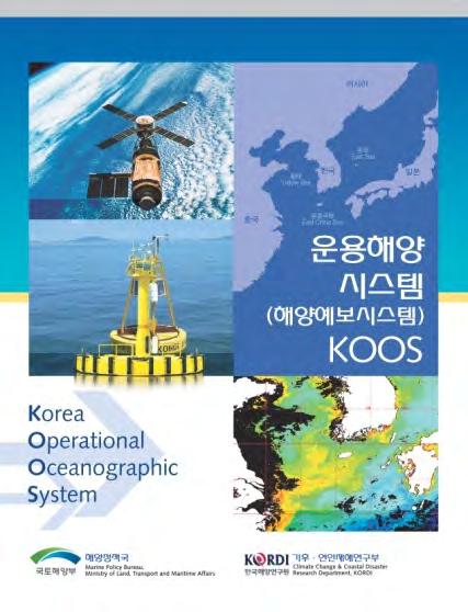
1 PICES-2010, Portland, USA October 21-31, 2010 Introduction of Korea Operational Oceanographic System (KOOS) Oct. 28, 2010 Kwang-Soon Park, Dong-Young Lee, Ki-Cheon Jun, Sang-Ik Kim, Jae-Il Kwon and Jung-Woon Choi Climate Change & Coastal Disaster Research Department
2 Outline 1 Introduction 2 Korea Operational Oceanographic System (KOOS) 3 Applications


3 What is KOOS? A system which can produce and provide a nowcast and forecast information of ocean/ coastal environmental change required for different maritime operations and a solution of pending problems in ocean related governmental agency, industrial circles and the public in Korea


4 Korea Operational Oceanographic System (KOOS) Provide data/info required for more rapid detection & timely prediction of ocean and coastal state changes for better management decisions, different industrial activities and a solution of pending problems Real-time ocean observing System Data Transmission, Management Numerical Modelling Nowcast and Forecast Applications
5 Project scope (August, 2009 ~ July, 2013) High-resolution Meteor. info. & input data for ocean prediction model High-resolution coastal sea state prediction system 3D regional and local ocean circulation model High-resolution sea surface winds, waves, storm surges, tides, currents and 3D regional/local circulation prediction info. Applications (Oil spill, Search & Rescue, Storm surge, etc.)
6 What Does It forecast? Some Core Variables Basic variables - Sea surface winds - Sea surface waves - Storm surges - Tide, tidal currents - 3D circulation (Regional/Local) - Temperature, salinity - Suspended sediment Applications - Storm surges - Search and Rescue - Oil spill - I-MAPS (Integrated-MAritime port Prediction System) - Sediment transport
 - Navy Coupled Ocean Data Assimilation, HYBRID")
")
7 Open boundary and Initial conditions for Ocean numerical models NHYCOM(NCODA HYCOM) - Navy Coupled Ocean Data Assimilation, HYBRID COORDINATE OCEAN MODEL - Global 1/12, 32 vertical layers 5 day hindcast and a 5 day forecast Data comparison to ARGO JAMSTEC(JAPAN) global model data


8 Observations for input data & validation Real-time ocean observing data - Ocean stations, buoys, tidal stations, etc. Remote sensing data - GOCI (Geostationary Ocean Color Imager) - NOAA AVHRR (SST, SSH) and etc.
9 Operational Weather Forecasting System(WRF WRF) geogrid WPS GFS Met_em.d01 WPS real.exe wrfinput_d01 wrfbdy_01 U10, V10, Pressure WRFV3 Run Wrfout_d01 Wrfout_d01 (netcdf format) Ocean models WPP WPP (ARWpost) (GrADS)
 Grid : 270 270 Latitude : 29.9 N ~ 39.6 N Longitude : 121.1 E ~ 133.")
10 Operational Weather Forecasting System(WRF WRF) WRF runs 2 times per day (09, 21LST) for 72 hours prediction D01 (20km) Grid : Latitude : 14.9 N ~ 52.5 N Longitude : E ~ E D02 (4km) Grid : Latitude : 29.9 N ~ 39.6 N Longitude : E ~ E
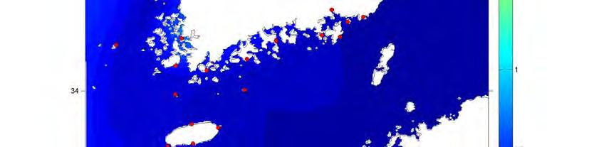
11 Operational Weather Forecasting System(WRF WRF) Sea surface wind Domain 1 Sea level pressure 2010/8/30/21 ~ 2010/09/02/21 (LST)


12 Comparisons of Wind Speed and Pressure WRF, MM5, HIRLAM, OBS. Site : Yellow Sea Buoy WRF : 4km, MM5 : 30km, HIRLAM : 7.5km
 with WRF results 2010/10/21/21 ~ 2010/10/24/21 (LST) Resolution: ~9")
13 Operational Wave Forecasting System (WAM( WAM,, 72 hrs) Wave Analysis Model (WAM) with WRF results 2010/10/21/21 ~ 2010/10/24/21 (LST) Resolution: ~9 Km
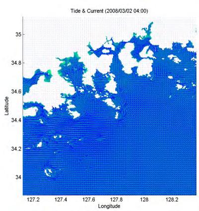
14 Operational storm surge prediction system Fine grid wind model Prediction of local wind Fine grid Typhoon wind model Wind, air pressure Tide model Fine grid storm surge model Prediction of local storm surge Shallow water Wave model Dissemination of information
 2) MD II : 1 1 (~2 km) 3) MD III: ~ 300 m One-way Nesting Forcing - 4 tidal constituents (M2,S2,O1,K1) - wind and pressure")
15 Operational storm surge prediction system Nested grid systems (KORDI-S) Domain : E, N Depth : Etopo5 Nested grids : 1) MD I : 5 5 (~9 km) 2) MD II : 1 1 (~2 km) 3) MD III: ~ 300 m One-way Nesting Forcing - 4 tidal constituents (M2,S2,O1,K1) - wind and pressure (PVM)


 Pressure")

")
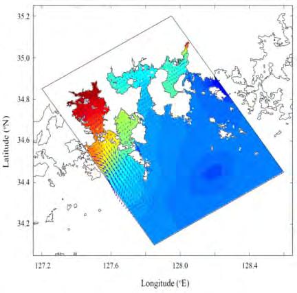
16 Operational storm surge prediction system Wind ( :00 ~ :00) Pressure Gunsan Storm surge (Regional sea) Storm surge (local area) Yeosu 9km 2km 300m
 1) FVCOM ~")

 Node = 240,517 Element =")
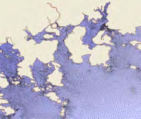
17 Operational Regional/Local Circulation Forecasting System(72 hrs) 1) FVCOM ~ About 400m resolution with WRF results ~ Tides, storm surge, oil spill, sediment transport ~ SWAN coupling (under study) Node = 240,517 Element = 455,906
 2) MOHID ~ 3")

 Grid : (1/12 ) Level2 Grid : (1/60")
18 Operational Regional/Local Circulation Forecasting System(72 hrs) 2) MOHID ~ 3 step nesting about 300m resolution with WRF results ~ Tides, storm surge, SAR, sediment transport ~ SWAN coupling (under study) Grid : (1/12 ) Level2 Grid : (1/60 ) Grid(1/360 )

 3) ROMS ~")


19 Operational Regional/Local Circulation Forecasting System(72 hrs) 3) ROMS ~ 2 regions, nesting up 50m resolution with WRF results ~ 2 way coupling with SWAN ~ Tides, SAR, Sediment transport 서해 1 구역


20 Operational 3D circulation forecasting system(72 hrs) ~ 9 km MOM3 52 o N ~ 10 km ROMS 48 o N o N o N o N o E 132 o E 135 o E 138 o E 141 o E 0
")
21 Operational 3D circulation forecasting system(72 hrs) Temperature Salinity


22 Maximum Movie Model Verification Surge Applications (Storm surge) Boryeong Typhoon KOMPAS in Sep. 2010
23 Applications (SAR) An example of SAR simulation
 Hebei spirit oil")
 Operational system Oil spill Text model in")
 Observing system 해양환경인자관측")

24 Oil spill simulation using FVCOM Flow chart of oil spill prediction (ex) Hebei spirit oil spill accident simulation( ) Operational system Oil spill Text model in here WDC wave Weather Pressure wind 발생지점, 유출류관련정보 ( 종류, 유출량 ) Observing system 해양환경인자관측 ( 조석, 해조류, 풍향풍속, 파랑, 기온, 수온, 염분 ) 오염물확산범위관측 Tidal curre nt curre nt tide DB current DB Temp Sal. Ocean model
25 <Yeosu> Applications I-MAPS (Integrated-MAritime port Prediction System) FVCOM ADCIRC ROMS MOHID
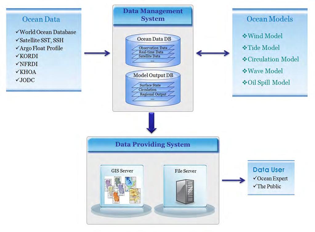
26 Data Management System & Web-GIS


27 Products of KOOS Forecasting information on ocean/coastal environment What are forecast informations? local sea surface wind local wave local storm surge tides current wind driven current temperature salinity suspended sediment conc. What are applications? Mitigation of coastal disaster Protection/restoration of environment and ecosystem Oil spill Improvement of Maritime operation SAR Sustaining use of ocean/coastal resources Ocean tourism/leisure


28 Users Maritime trade Navy Local government Ocean construction company Public Power company Univ. Inst. Fishermen Coast Guard KMA MLTM NEMA NEMA : National Emergency management Agency
29 Closing Remarks As the first stage of KOOS, Korea has been establishing realtime coastal/ocean monitoring system since Currently, 94 real-time coastal observing stations are operating. As the 2nd stage of KOOS, KORDI has been carrying out a national program for development of coastal/ocean forecasting system since August So far, various ocean models and applications have been established and under testing. KOOS can contribute to development of ocean observing system and can be part of ocean observing system in North East Asian Region (NEAR-GOOS).


30 GEOSS NEAR-GOOS GOOS KOOS Thank you!
Urgent Computing for Hurricane Forecasts
 Urgent Computing for Hurricane Forecasts Gabrielle Allen Center for Computation & Technology Dept Computer Science Louisiana State University gallen@cct.lsu.edu Representing the SURA Coastal Ocean Observing
Hindcasting of Storm Surge by Typhoon 0314(Maemi) in Masan Bay, Korea
 in Masan Bay, Korea") Hindcasting of Storm Surge by Typhoon 0314(Maemi) in Masan Bay, Korea See-Whan Kang 1 ;Kicheon Jun 1 ; Kwang-Soon Park 1 ; Sung-Dae Han 2 1 Coastal Engineering Research Division, Korea Ocean Research and
Hindcasting of Storm Surge by Typhoon 0314(Maemi) in Masan Bay, Korea See-Whan Kang 1 ;Kicheon Jun 1 ; Kwang-Soon Park 1 ; Sung-Dae Han 2 1 Coastal Engineering Research Division, Korea Ocean Research and
PREDICTION OF OIL SPILL TRAJECTORY WITH THE MMD-JMA OIL SPILL MODEL
 PREDICTION OF OIL SPILL TRAJECTORY WITH THE MMD-JMA OIL SPILL MODEL Project Background Information MUHAMMAD HELMI ABDULLAH MALAYSIAN METEOROLOGICAL DEPARTMENT(MMD) MINISTRY OF SCIENCE, TECHNOLOGY AND INNOVATION
Overview of NOS Coastal Ocean Operational Forecast Systems
 Overview of NOS Coastal Ocean Operational Forecast Systems Aijun Zhang NOAA/NOS Center for Operational Oceanographic Products and Services (CO-OPS) Frank Aikman III NOAA/NOS/OCS Coast Survey Development
Earth Observation in coastal zone MetOcean design criteria
 ESA Oil & Gas Workshop 2010 Earth Observation in coastal zone MetOcean design criteria Cees de Valk BMT ARGOSS Wind, wave and current design criteria geophysical process uncertainty modelling assumptions
Data Assimilation of Argo Profiles in Northwest Pacific Yun LI National Marine Environmental Forecasting Center, Beijing
 Data Assimilation of Argo Profiles in Northwest Pacific Yun LI National Marine Environmental Forecasting Center, Beijing www.nmefc.gov.cn National Marine Environmental Forecasting Center Established in
Impact of Sea Level Rise on Future Storm-induced Coastal Inundation
 Impact of Sea Level Rise on Future Storm-induced Coastal Inundation Changsheng Chen School for Marine Science and Technology, University of Massachusetts-Dartmouth Email: c1chen@umassd.edu 04/14/2015 Outline
Operational Estuarine & Coastal Forecast Systems in NOAA s. National Ocean Service
 Operational Estuarine & Coastal Forecast Systems in NOAA s. National Ocean Service Eugene Wei, Frank Aikman III and Richard Patchen NOAA S S National Ocean Service Workshop on: Data Assimilation in Support
Saiful Islam Anisul Haque
 Workshop on Disaster Prevention/Mitigation Measures against Floods and Storm Surges in Bangladesh on 17-21 November, 2012, in Kyoto University, Japan Component 2: Flood disaster risk assessment and mitigation
Development and Application of the Chinese Operational Hydrological Forecasting System
 Development and Application of the Chinese Operational Hydrological Forecasting System Guimei LIU National Marine Environmental Forecasting Center, Beijing www.nmefc.gov.cn Contents Background Operational
The Relation between the Red Tide Occurrence and the Sea Water Temperature in South Sea of Korea
 , pp.132-136 http://dx.doi.org/10.14257/astl.2017.145.26 The Relation between the Red Tide Occurrence and the Sea Water Temperature in South Sea of Korea Do-Hyun Hwang 1, Su-Ho Bak 1, Heung-Min Kim 1,
Alaska Ocean Observing System 101 Anchorage, Alaska
 Alaska Ocean Observing System 101 Anchorage, Alaska Molly McCammon, Director Alaska Ocean Observing System (AOOS) A Regional Observing System within the Integrated Ocean Observing System www.aoos.org IOOS
Indian Ocean Forecast System (INDOFOS) Abhisek Chatterjee
 Abhisek Chatterjee") Indian Ocean Forecast System (INDOFOS) Abhisek Chatterjee Earth System Sciences Organisation (ESSO) Indian National Centre for Ocean Information Services (INCOIS) Ministry of Earth Sciences, Government
Indian Ocean Forecast System (INDOFOS) Abhisek Chatterjee Earth System Sciences Organisation (ESSO) Indian National Centre for Ocean Information Services (INCOIS) Ministry of Earth Sciences, Government
Data Management for Algal Monitoring in the Gulf of Mexico
 Data Management for Algal Monitoring in the Gulf of Mexico Scott Cross NOAA National Oceanographic Data Center/ Coastal Data Development Center (NCDDC) Outline History Current & Future Directions Needs
Application of GOCI Satellite Data to Ocean Modeling
 GOCI Satellite Data and ROMS Ocean Model 1409 Application of GOCI Satellite Data to Ocean Modeling Chang S. Kim, Young-Je Park, Kwang Soon Park, Jae Seol Shim and Hak-Soo Lim Coastal Disaster Research
SST (NRL/NLOM, 28 Sept. 2004) (A global, surface layer product)
 (A global, surface layer product)") SST (NRL/NLOM, 28 Sept. 2004) (A global, surface layer product) SST (NRL/NLOM, 28 Sept. 2004) SST Forecast (NRL/NLOM, 20 Oct. 2004) UH/IPRC Asia-Pacific Data-Research Center (APDRC) Jay McCreary, Peter
SST (NRL/NLOM, 28 Sept. 2004) (A global, surface layer product) SST (NRL/NLOM, 28 Sept. 2004) SST Forecast (NRL/NLOM, 20 Oct. 2004) UH/IPRC Asia-Pacific Data-Research Center (APDRC) Jay McCreary, Peter
SIMULATION OF ATMOSPHERIC STATES FOR THE CASE OF YEONG-GWANG STORM SURGE ON 31 MARCH 2007 : MODEL COMPARISON BETWEEN MM5, WRF AND COAMPS
 SIMULATION OF ATMOSPHERIC STATES FOR THE CASE OF YEONG-GWANG STORM SURGE ON 31 MARCH 2007 : MODEL COMPARISON BETWEEN MM5, WRF AND COAMPS JEONG-WOOK LEE 1 ; KYUNG-JA HA 1* ; KI-YOUNG HEO 1 ; KWANG-SOON
JCOMM-CHy Coastal Inundation Forecasting Demonstration Project (CIFDP)
") WMO World Meteorological Organization Working together in weather, climate and water JCOMM-CHy Coastal Inundation Forecasting Demonstration Project (CIFDP) Coastal Flooding & Vulnerable Populations Coastal
WMO World Meteorological Organization Working together in weather, climate and water JCOMM-CHy Coastal Inundation Forecasting Demonstration Project (CIFDP) Coastal Flooding & Vulnerable Populations Coastal
West Florida Shelf and Tampa Bay Responses to Hurricane Irma: What Happened and Why
 West Florida Shelf and Tampa Bay Responses to Hurricane Irma: What Happened and Why R.H. Weisberg Y. Liu J. Chen College of Marine Science University of South Florida St. Petersburg, FL SECOORA Webinar
Operational Forecasting of Marine Meteorology by Model and Observation in KMA. Jang-Won SEO
 Operational Forecasting of Marine Meteorology by Model and Observation in KMA Jang-Won SEO Global Environment Research Lab. National Institute of Meteorological Research DBCP-XXIII Session of the Data
OSE/OSSEs at NOAA. Eric Bayler NOAA/NESDIS/STAR
 OSE/OSSEs at NOAA Eric Bayler NOAA/NESDIS/STAR OSE/OSSEs at NOAA NOAA Leadership view: Relatively inexpensive way to: Assess the impact of potential new observations Refine and redirect current observing
Liana Talaue McManus. Division of Marine Affairs and Policy Rosenstiel School of Marine & Atmospheric Science University of Miami
 Liana Talaue McManus Division of Marine Affairs and Policy Rosenstiel School of Marine & Atmospheric Science University of Miami Outline 1. Coasts as vulnerable & resilient social ecological systems 2.
NWS Operational Marine and Ocean Forecasting. Overview. Ming Ji. Ocean Prediction Center National Weather Service/NCEP. CIOSS/CoRP
 NWS Operational Marine and Ocean Forecasting Overview Ming Ji Ocean Prediction Center National Weather Service/NCEP CIOSS/CoRP CoRP Symposium Corvallis, OR Aug. 12-13, 13, 2008 Titanic Telegram Marine
NORTHEAST COASTAL OCEAN FORECAST SYSTEM (NECOFS)
") NORTHEAST COASTAL OCEAN FORECAST SYSTEM (NECOFS) R. C. Beardsley and C. Chen MITSG 13-27 Sea Grant College Program Massachusetts Institute of Technology Cambridge, Massachusetts 02139 NOAA Grant No. NA10OAR4170086
NORTHEAST COASTAL OCEAN FORECAST SYSTEM (NECOFS) R. C. Beardsley and C. Chen MITSG 13-27 Sea Grant College Program Massachusetts Institute of Technology Cambridge, Massachusetts 02139 NOAA Grant No. NA10OAR4170086
What is CERA? Coastal Emergency Risks Assessment
 What is CERA? Coastal Emergency Risks Assessment Visualization tool using OGC standards Displays the outputs from the ADCIRC storm surge model or other coastal models Represents the maps on interactive
Storm surge forecasting and other Met Office ocean modelling
 Storm surge forecasting and other Met Office ocean modelling EMODnet stakeholder meeting Clare O Neill + many others Outline Ocean modelling at the Met Office Storm surge forecasting Current operational
Critical Issues in Assessment of Offshore Wind Farm Development on Dispersion and Settling of Scallop Larvae in the Northeast U.S.
 Critical Issues in Assessment of Offshore Wind Farm Development on Dispersion and Settling of Scallop Larvae in the Northeast U.S. Coastal Ocean Changsheng Chen School for Marine Science and Technology
Coastal Inundation Forecasting and Community Response in Bangladesh
 WMO Coastal Inundation Forecasting and Community Response in Bangladesh Bapon (SHM) Fakhruddin Nadao Kohno 12 November 2015 System Design for Coastal Inundation Forecasting CIFDP-PSG-5, 14-16 May 2014,
John Kindle. Sergio derada Igor Shulman Ole Martin Smedstad Stephanie Anderson. Data Assimilation in Coastal Modeing April
 John Kindle Sergio derada Igor Shulman Ole Martin Smedstad Stephanie Anderson Data Assimilation in Coastal Modeing April 3 2007 MODELS Motivation: Global->Coastal Real-Time Regional Coastal Models Global
The Northeast Coastal Ocean Forecast System (NECOFS) and Storm Surge and Inundation Prediction. Status and Initial Ideas
 and Storm Surge and Inundation Prediction. Status and Initial Ideas") The Northeast Coastal Ocean Forecast System (NECOFS) and Storm Surge and Inundation Prediction Status and Initial Ideas Changsheng Chen (UMassD) and Bob Beardsley (WHOI) Website: http://fvcom.smast.umassd.edu
The Northeast Coastal Ocean Forecast System (NECOFS) and Storm Surge and Inundation Prediction Status and Initial Ideas Changsheng Chen (UMassD) and Bob Beardsley (WHOI) Website: http://fvcom.smast.umassd.edu
Importance of air-sea interaction on the coupled typhoon-wave-ocean modeling
 Importance of air-sea interaction on the coupled typhoon-wave-ocean modeling Collaborators: I. Ginis (GSO/URI) T. Hara (GSO/URI) B. Thomas (GSO/URI) H. Tolman (NCEP/NOAA) IL-JU MOON ( 文一柱 ) Cheju National
PROJECTION OF FUTURE STORM SURGE DUE TO CLIMATE CHANGE AND ITS UNCERTAINTY A CASE STUDY IN THE TOKYO BAY
 Proceedings of the Sixth International Conference on Asian and Pacific Coasts (APAC 2011) December 14 16, 2011, Hong Kong, China PROJECTION OF FUTURE STORM SURGE DUE TO CLIMATE CHANGE AND ITS UNCERTAINTY
Flood and Sea Level Rise Mapping Methodologies: The Way Forward
 Flood and Sea Level Rise Mapping Methodologies: The Way Forward Malcolm L. Spaulding Professor Emeritus, Ocean Engineering University of Rhode Island spaulding@egr.uri.edu Interagency Coordination Meeting
Design and Implementation of a NOAA/NOS Cook Inlet and Shelikof Straits Circulation Modeling System
 Design and Implementation of a NOAA/NOS Cook Inlet and Shelikof Straits Circulation Modeling System Presented at a NOAA/AEA Stakeholders Meeting, August 24, 2011, Anchorage Alaska Richard Patchen and Lyon
The Field Research Facility, Duck, NC Warming Ocean Observations and Forecast of Effects
 The Field Research Facility, Duck, NC Warming Ocean Observations and Forecast of Effects A potential consequence of a warming ocean is more frequent and more intense wind events (Hurricanes & Typhoons)
C o p e r n i c u s M a r i n e E n v i r o n m e n t M o n i t o r i n g S e r v i c e
 C o p e r n i c u s M a r i n e E n v i r o n m e n t M o n i t o r i n g S e r v i c e Modélisation côtière Copernicus EU Copernicus EU Copernicus EU www.copernicus.eu Q u e s t - c e q u u n m o d è
Comparison of directional wave spectrum hindcast to the buoy data measured near the typhoon path
 Comparison of directional wave spectrum hindcast to the buoy data measured near the typhoon path TAERIM KIM and JAEHYUK LEE trkim@kunsan.ac.kr Department of Ocean Science and Engineering Kunsan National
A Modeling Study on Flows in the Strait of Hormuz (SOH)
") A Modeling Study on Flows in the Strait of Hormuz (SOH) Peter C Chu & Travis Clem Naval Postgraduate School Monterey, CA 93943, USA IUGG 2007: PS005 Flows and Waves in Straits. July 5-6, Perugia, Italy
A Modeling Study on Flows in the Strait of Hormuz (SOH) Peter C Chu & Travis Clem Naval Postgraduate School Monterey, CA 93943, USA IUGG 2007: PS005 Flows and Waves in Straits. July 5-6, Perugia, Italy
Evaluation of the sea ice forecast at DMI
 DMI Evaluation of the sea ice forecast at DMI Till A. S. Rasmussen 1 Kristine S. Madsen 1, Mads H. Ribergaard 1, Leif T.Pedersen 1, Jacob L Høyer 1, Gorm Dybkjær 1, Mads Bruun Poulsen 2 and Sofie Abildgaard
Hyperlocal Marine Weather: What s Happening?
 Hyperlocal Marine Weather: What s Happening? André van der Westhuysen 1,2 and Jeff McQueen 1 1 NOAA / National Weather Service National Centers for Environmental Prediction 2 I.M Systems Group, Rockville
An Ensemble based Reliable Storm Surge Forecasting for Gulf of Mexico
 An Ensemble based Reliable Storm Surge Forecasting for Gulf of Mexico Umer Altaf Delft University of Technology, Delft ICES, University of Texas at Austin, USA KAUST, Saudi Arabia JONSMOD 2012, Ifremer,
Mersea Oil Spill Drift Forecast Demonstrations in TOP2
 Mersea Oil Spill Drift Forecast Demonstrations in TOP2 Bruce Hackett (met.no), George Zodiatis (UCY), Pierre Daniel (MeteoFrance), Francois Parthiot (Cedre) Presented at 3rd Mersea Plenary Meeting, CNR,
Simulation of storm surge and overland flows using geographical information system applications
 Coastal Processes 97 Simulation of storm surge and overland flows using geographical information system applications S. Aliabadi, M. Akbar & R. Patel Northrop Grumman Center for High Performance Computing
MERSEA Marine Environment and Security for the European Area
 MERSEA Marine Environment and Security for the European Area Development of a European system for operational monitoring and forecasting of the ocean physics, biogeochemistry, and ecosystems, on global
Coastal Cities-Coastal Impacts: 'The Tides They Are A-Changin
 Coastal Cities-Coastal Impacts: 'The Tides They Are A-Changin Susan K. Avery Woods Hole Oceanographic Institution Thanks to: Jeff Donnelly, Chris Reddy, Porter Hoagland, Jim Price, Dennis McGillicuddy,
Tampa Bay Storm Surge & Wave Vulnerability, Response to Hurricane Irma and Tools for Future Use
 Tampa Bay Storm Surge & Wave Vulnerability, Response to Hurricane Irma and Tools for Future Use Robert H. Weisberg with J. Chen, Y. Liu and L. Zheng College of Marine Science University of South Florida
Effect of coastal resolution on global estimates of tidal energy dissipation
 Effect of coastal resolution on global estimates of tidal energy dissipation Maialen Irazoqui Apecechea, Martin Verlaan Contents The GTSMv2.0 model Characteristics Major developments Applications Coastal
INTERCOMPARISON OF NOAA and KMA WINDS WITH BUOY DATA IN FAR EAST SEA
 INTERCOMPARISON OF NOAA and KMA WINDS WITH BUOY DATA IN FAR EAST SEA H. S. Chen ABSTRACT During the period from October 1 to December 31, 2000, WOM has collected wind and wave data from wind models and
John Callahan (Delaware Geological Survey) Kevin Brinson, Daniel Leathers, Linden Wolf (Delaware Environmental Observing System)
 Kevin Brinson, Daniel Leathers, Linden Wolf (Delaware Environmental Observing System)") John Callahan (Delaware Geological Survey) Kevin Brinson, Daniel Leathers, Linden Wolf (Delaware Environmental Observing System) Delaware is extremely vulnerable to the impacts of coastal flooding Tropical
John Callahan (Delaware Geological Survey) Kevin Brinson, Daniel Leathers, Linden Wolf (Delaware Environmental Observing System) Delaware is extremely vulnerable to the impacts of coastal flooding Tropical
WRF Modeling System Overview
 WRF Modeling System Overview Wei Wang & Jimy Dudhia Nansha, Guangdong, China December 2015 What is WRF? WRF: Weather Research and Forecasting Model Used for both research and operational forecasting It
1.2 DEVELOPMENT OF THE NWS PROBABILISTIC EXTRA-TROPICAL STORM SURGE MODEL AND POST PROCESSING METHODOLOGY
 1.2 DEVELOPMENT OF THE NWS PROBABILISTIC EXTRA-TROPICAL STORM SURGE MODEL AND POST PROCESSING METHODOLOGY Huiqing Liu 1 and Arthur Taylor 2* 1. Ace Info Solutions, Reston, VA 2. NOAA / NWS / Science and
: : User Manual: : - 10 December
 : : User Manual: : - 0 December 06 - : : User Manual: : Table of Contents. Map Control. How to move a map. How to zoom in and out a map 4. How to inquire Ocean Currents. How to inquire predicted current
JOINT WMO TECHNICAL PROGRESS REPORT ON THE GLOBAL DATA PROCESSING AND FORECASTING SYSTEM AND NUMERICAL WEATHER PREDICTION RESEARCH ACTIVITIES FOR 2016
 JOINT WMO TECHNICAL PROGRESS REPORT ON THE GLOBAL DATA PROCESSING AND FORECASTING SYSTEM AND NUMERICAL WEATHER PREDICTION RESEARCH ACTIVITIES FOR 2016 New Zealand / Meteorological Service of New Zealand
PICES W3 [D-504], Sep 22, 2017, 11:40-12:05
![PICES W3 [D-504], Sep 22, 2017, 11:40-12:05](/thumbs/79/79974722.jpg "PICES W3 [D-504], Sep 22, 2017, 11:40-12:05") PICES W3 [D-504], Sep 22, 2017, 11:40-12:05 Individual-based model of chub mackerel (Scomber japonicus) covering from larval to adult stages to project climate-driven changes in their spatial distribution
PICES W3 [D-504], Sep 22, 2017, 11:40-12:05 Individual-based model of chub mackerel (Scomber japonicus) covering from larval to adult stages to project climate-driven changes in their spatial distribution
3.6 EFFECTS OF WINDS, TIDES, AND STORM SURGES ON OCEAN SURFACE WAVES IN THE JAPAN/EAST SEA
 3.6 EFFECTS OF WINDS, TIDES, AND STORM SURGES ON OCEAN SURFACE WAVES IN THE JAPAN/EAST SEA Wei Zhao 1, Shuyi S. Chen 1 *, Cheryl Ann Blain 2, Jiwei Tian 3 1 MPO/RSMAS, University of Miami, Miami, FL 33149-1098,
J-Rapid PI: Jun Sasaki 1 T. Suzuki 1 and R. U. A. Wiyono 1. Rapid PI: Changsheng Chen 2 C. Beardsley 3, Z. Lai 2, R., H. Lin 2, J. Lin 3 and R.
 Collaborative Research: The Japan March 11 Earthquake: Tsunami inundation, and initial spread of Fukushima Dai-ichi Radionuclides into the Pacific Ocean: Model Assessment J-Rapid PI: Jun Sasaki 1 T. Suzuki
E x a m p l e s o f t o o l s f o r s e a s i t u a t i o n a l a w a r e n e s s u s i n g C M E M S d a t a. Copernicus EU
 E x a m p l e s o f t o o l s f o r s e a s i t u a t i o n a l a w a r e n e s s u s i n g C M E M S d a t a Copernicus EU Copernicus EU Copernicus EU www.copernicus.eu S e a S i t u a t i o n a l A w
4DVAR Data Assimilation with Chesapeake Bay Operational Forecasting System
 4DVAR Data Assimilation with Chesapeake Bay Operational Forecasting System Bin Zhang 1, Matt Hoffman 2, Lyon Lanerolle 3, Chris Brown 1,4 1 Cooperative Institute of Climate & Satellites/Earth System Science
Research of the Influential Factors on the Simulation of Storm Surge in the Bohai Sea
 Send Orders for Reprints to reprints@benthamscience.net The Open Mechanical Engineering Journal, 2014, 8, 151-156 151 Open Access Research of the Influential Factors on the Simulation of Storm Surge in
WRF Modeling System Overview
 WRF Modeling System Overview Jimy Dudhia What is WRF? WRF: Weather Research and Forecasting Model Used for both research and operational forecasting It is a supported community model, i.e. a free and shared
Forcing ocean model with atmospheric model outputs to simulate storm surge in the Bangladesh coast
 Forcing ocean model with atmospheric model outputs to simulate storm surge in the Bangladesh coast Nabir Mamnun 1, 2, Lucy Brechino 3, Md. Rashed-Un-Nabi 2 1. Nansen-Bangladesh International Centre for
Hindcast Arabian Gulf
 Hindcast Arabian Gulf Image of isobars of atmospheric pressure and hindcast wind- and wave field over the Arabian Gulf during a storm in January 1993. Detailed wave studies are supported by nesting of
PREDICTION OF DESIGN WATER LEVEL DUE TO STORM SURGE AT THE SEOGWIPO COASTAL ZONE IN KOREA
 Proceedings of the 7 th International Conference on Asian and Pacific Coasts (APAC 2013) Bali, Indonesia, September 24-26, 2013 PREDICTION OF DESIGN WATER LEVEL DUE TO STORM SURGE AT THE SEOGWIPO COASTAL
DEVELOPMENT OF AN INUNDATION FORECAST SYSTEM FOR MASSACHUSETTS COASTAL WATERS
 DEVELOPMENT OF AN INUNDATION FORECAST SYSTEM FOR MASSACHUSETTS COASTAL WATERS C. Chen and R. C. Beardsley MITSG 13-26 Sea Grant College Program Massachusetts Institute of Technology Cambridge, Massachusetts
An Integrated Storm Surge, Hurricane Wave, Salinity and Sediment Transport Modeling System for Breton Sound, LA
 An Integrated Storm Surge, Hurricane Wave, Salinity and Sediment Transport Modeling System for Breton Sound, LA Q. Jim Chen Department of Civil and Environmental Engineering qchen@lsu.edu Acknowledgements
The Application of POM to the Operational Tidal Forecast for the Sea around Taiwan
 The Application of POM to the Operational Tidal Forecast for the Sea around Taiwan Shan-Pei YEH 1 Hwa CHIEN Sen JAN 3 and Chia Chuen KAO 4 1 Coastal Ocean Monitoring Center, National Cheng Kung University,
Provide dynamic understanding of physical environment for ecosystem science and offshore operations and planning.
 ENHANCING THE CANADIAN METAREAS OPERATIONAL COUPLED OCEAN-ICE- ATMOSPHERE ANALYSIS AND FORECASTING SYSTEM FOR FINE-SCALE APPLICATIONS IN THE BEAUFORT SEA by Fraser Davidson, Greg Smith, Youyu Lu, Jean-Francois
Session 3B : Delivering services to society: forecasting Plenary Paper : Short term forecasts: delivery and observational requirements
 Session 3B : Delivering services to society: forecasting Plenary Paper : Short term forecasts: delivery and observational requirements Gary B. Brassington CAWCR, Bureau of Meteorology Chair of JCOMM Expert
METOC at Defence Center for Operational Oceanography (FCOO)
") METOC at Defence Center for Operational Oceanography (FCOO) Forsvarets Center for Operativ Oceanografi Dr. Johan Söderqvist Oceanographer jos@fcoo.dk FCOO Staff (13 pos.) Geophysical expertise: oceanography,
METOC at Defence Center for Operational Oceanography (FCOO) Forsvarets Center for Operativ Oceanografi Dr. Johan Söderqvist Oceanographer jos@fcoo.dk FCOO Staff (13 pos.) Geophysical expertise: oceanography,
OCEANOGRAPHIC DATA MANAGEMENT
 OCEANOGRAPHIC DATA MANAGEMENT Presented to: Environmental Disaster Data Management Meeting Russ Beard Director, National Coastal Data Development Center Interim Science Coordinator, Gulf Restoration Council
Altimetry for Coastal Applications. Paul M. DiGiacomo and Amanda Bittinger NOAA CoastWatchatch Program 5 February 2008
 Altimetry for Coastal Applications Paul M. DiGiacomo and Amanda Bittinger NOAA CoastWatchatch Program 5 February 2008 IGOS COASTAL THEME REPORT Published January 2006, IOC http://www.igospartners.org/d
Environmental Data In Support of Search & Rescue Operations in the Central Mediterranean Sea
 Environmental Data In Support of Search & Rescue Operations in the Central Mediterranean Sea Dr. Eric Comerma (RPS ASA) eric.comerma@rpsgroup.com Cathleen Turner (RPS ASA) Prof. Aldo Drago (Univ. of Malta)
Advances in Coastal Inundation Simulation Using Unstructured-Grid Coastal Ocean Models
 Advances in Coastal Inundation Simulation Using Unstructured-Grid Coastal Ocean Models Bob Beardsley (WHOI) Changsheng Chen (UMass-Dartmouth) Bob Weisberg (U. South Florida) Joannes Westerink (U. Notre
US Army Corps of Engineers BUILDING STRONG. Mary Cialone, Norberto Nadal-Caraballo, and Chris Massey
 North Atlantic Coast Comprehensive Study Storm Selection and Numerical Modeling An Overview Computing the Joint Probability of Storm Forcing Parameters from Maine to Virginia Mary Cialone, Norberto Nadal-Caraballo,
Pacific HYCOM. E. Joseph Metzger, Harley E. Hurlburt, Alan J. Wallcraft, Luis Zamudio and Patrick J. Hogan
 Pacific HYCOM E. Joseph Metzger, Harley E. Hurlburt, Alan J. Wallcraft, Luis Zamudio and Patrick J. Hogan Naval Research Laboratory, Stennis Space Center, MS Center for Ocean-Atmospheric Prediction Studies,
Improvement of MPAS on the Integration Speed and the Accuracy
 ICAS2017 Annecy, France Improvement of MPAS on the Integration Speed and the Accuracy Wonsu Kim, Ji-Sun Kang, Jae Youp Kim, and Minsu Joh Disaster Management HPC Technology Research Center, Korea Institute
The Portuguese Forecasting System. Instituto Superior Técnico Lisbon Portugal. Guillaume Riflet, POL workshop, 22nd 24th October, Mallorca
 The Portuguese Forecasting System Instituto Superior Técnico Lisbon Portugal Guillaume Riflet, POL workshop, 22nd 24th October, Mallorca Contents The portuguese in the ECOOP framework Observation system
Changes of storm surge and typhoon intensities under the future global warming conditions Storm Surge Congress 2010
 Changes of storm surge and typhoon intensities under the future global warming conditions Storm Surge Congress 2010 Il-Ju Moon & S. M. Oh Jeju (Cheju) National University, Korea Tropical Cyclone (TC) and
New developments in data assimilation in MIKE 21/3 FM Assimilation of along-track altimetry data with correlated measurement errors
 New developments in data assimilation in MIKE 21/3 FM Assimilation of along-track altimetry data with correlated measurement errors EnKF Workshop 2016-06-20 Jesper Sandvig Mariegaard Henrik Andersson DHI
M. Liste 1, M. Grifoll 2, I. Keupers 1, J. Fernández 3, H. Ortega 1, J. Monbaliu 1
 M. Liste 1, M. Grifoll 2, I. Keupers 1, J. Fernández 3, H. Ortega 1, J. Monbaliu 1 1 Hydraulics Laboratory (K.U.Leuven, Belgium) 2 Laboratori d Enginyeria Marítima (LIM/UPC, Spain) 3 SIMO, Spain. Motivation
AMPS Update June 2017
 AMPS Update June 2017 Kevin W. Manning Jordan G. Powers Mesoscale and Microscale Meteorology Laboratory National Center for Atmospheric Research Boulder, CO 12th Workshop on Antarctic Meteorology and Climate
Modeling the North West European Shelf using Delft3D Flexible Mesh
 Modeling the North West European Shelf using Delft3D Flexible Mesh 2nd JCOMM Scientific and Technical Symposium on Storm Surges, 8-13 Nov. 2015, Key West, USA; Firmijn Zijl Outline of this presentation
The MSC Beaufort Wind and Wave Reanalysis
 The MSC Beaufort Wind and Wave Reanalysis Val Swail Environment Canada Vincent Cardone, Brian Callahan, Mike Ferguson, Dan Gummer and Andrew Cox Oceanweather Inc. Cos Cob, CT, USA Introduction: History
The Delaware Environmental Monitoring & Analysis Center
 The Delaware Environmental Monitoring & Analysis Center Tina Callahan Delaware Estuary Science & Environmental Summit 2013 January 27-30, 2013 What is DEMAC? Delaware Environmental Monitoring & Analysis
Early results and plans for the future. Robert Atlas
 Observing System Simulation Experiments: Methodology, Early results and plans for the future Robert Atlas National Oceanic and Atmospheric Administration Atlantic Oceanographic and Meteorological Laboratory
Yi Chao Jet Propulsion Laboratory California Institute of Technology & Joint Institute for Regional Earth System Science and Engineering (JIFRESSE)
") Strategy to Develop a 3D Ocean Circulation Forecasting System for Cook Inlet Yi Chao Jet Propulsion Laboratory California Institute of Technology & Joint Institute for Regional Earth System Science and
Strategy to Develop a 3D Ocean Circulation Forecasting System for Cook Inlet Yi Chao Jet Propulsion Laboratory California Institute of Technology & Joint Institute for Regional Earth System Science and
Bistandsprosjekter i Sørøst-Asia
 Bistandsprosjekter i Sørøst-Asia -Sikre liv og verdier Lars R. Hole, Hanneke Luijting, Tor Ivar Mathisen og Kristine Gjesdal September 2017 Norwegian Meteorological Institute Background Ministry of Foreign
Coupled Ocean Circulation and Wind-Wave Models With Data Assimilation Using Altimeter Statistics
 Coupled Ocean Circulation and Wind-Wave Models With Data Assimilation Using Altimeter Statistics Abstract ZHANG HONG, SANNASIRAJ, S.A., MD. MONIRUL ISLAM AND CHOO HENG KEK Tropical Marine Science Institute,
The 2009 Hurricane Season Overview
 The 2009 Hurricane Season Overview Jae-Kyung Schemm Gerry Bell Climate Prediction Center NOAA/ NWS/ NCEP 1 Overview outline 1. Current status for the Atlantic, Eastern Pacific and Western Pacific basins
Forecast of Nearshore Wave Parameters Using MIKE-21 Spectral Wave Model
 Forecast of Nearshore Wave Parameters Using MIKE-21 Spectral Wave Model Felix Jose 1 and Gregory W. Stone 2 1 Coastal Studies Institute, Louisiana State University, Baton Rouge, LA 70803 2 Coastal Studies
Update on SCOPE-Nowcasting Pilot Project Real Time Ocean Products Suman Goyal Scientist-E
 Update on SCOPE-Nowcasting Pilot Project Real Time Ocean Products Suman Goyal Scientist-E 19-22 Nov 2013 SCOPE-Nowcasting-1 Agenda Item 5 Pilot Projects Overview Users /Clients User requirements Product
Seasonal Simulaions of a coupled ice-ocean model in the Bohai Sea and North Yellow Sea
 Seasonal Simulaions of a coupled ice-ocean model in the Bohai Sea and North Yellow Sea Yu LIU,Qinzheng LIU,Jie Su*, Shan BAI,Maoning Tang National Marine Environmental Forecasting Center * Ocean University
Add NOAA nowcoast Layers to Maps
 WebEOC Maps Add-on Quick Reference Guide Add NOAA nowcoast Layers to Maps Overview With Maps Add-on, you can configure an unlimited number of map layers. These layers allow you to control the data you
Advancing Real Time Observations and Coastal Modeling Forecasts-
 Advancing Real Time Observations and Coastal Modeling Forecasts- Moving Forward in a Changing Coastal Landscape Next Generation Navigation-Coastal Operations- Coastal and Nearshore Coastal Operational
Short-term sea ice forecasts with the RASM-ESRL coupled model
 Short-term sea ice forecasts with the RASM-ESRL coupled model A testbed for improving simulations of ocean-iceatmosphere interactions in the marginal ice zone Amy Solomon 12, Janet Intrieri 2, Mimi Hughes
Comparison between vertical shear mixing and surface wave-induced mixing in the global ocean
 Comparison between vertical shear mixing and surface wave-induced mixing in the global ocean Fangli Qiao and Chuanjiang Huang Key Laboratory of Marine Science and Numerical Modeling First Institute of
Hurricane Season 2010 & NOAA s Deepwater Response
 Hurricane Season 2010 & NOAA s Deepwater Response What s Happened? What Will 2010 Bring? Possible Shoreline Effects Darin Figurskey Meteorologist-in-Charge NOAA s NWS Raleigh, NC NOAA s National Weather
STORM SURGE SIMULATION IN NAGASAKI DURING THE PASSAGE OF 2012 TYPHOON SANBA
 STORM SURGE SIMULATION IN NAGASAKI DURING THE PASSAGE OF 2012 TYPHOON SANBA D. P. C. Laknath 1, Kazunori Ito 1, Takahide Honda 1 and Tomoyuki Takabatake 1 As a result of global warming effect, storm surges
Study on Air-Sea Interaction under Typhoon and Its Application of Two Important Projects
 ESCAP/WMO Typhoon Committee Technical Conference (TC50 TECO) Study on Air-Sea Interaction under Typhoon and Its Application of Two Important Projects Li Yongping Shanghai Typhoon Institute/CMA 2018.02.26
Topics 1. IOOS on the US East Coast. 2. Regional Physical & Ecosystem Modeling Efforts
 Topics 1. IOOS on the US East Coast National Federation of Regional Associations http://usnfra.org - NERACOOS - MACOORA 2. Regional Physical & Ecosystem Modeling Efforts Northeast Regional Association