What is CERA? Coastal Emergency Risks Assessment
|
|
|
- Beverley Nicholson
- 6 years ago
- Views:
Transcription
1 What is CERA? Coastal Emergency Risks Assessment Visualization tool using OGC standards Displays the outputs from the ADCIRC storm surge model or other coastal models Represents the maps on interactive websites Works near real-time

2 Visualize ADCIRC Data Visualization & Graphics Applications Customized ADCIRC Visualization Tools Open Source, Easy Use Commercial, Technical Knowledge Customized Website ADCIRC Analysis Tools ParaView Matlab CERA FigureGen StormSurgeViz (AdcircViz)

3 CERA Storm Surge Websites tightly coupled to the ADCIRC Surge Guidance System relies on text advisories from NOAA s NHC The ASGS delivers model output from the ADCIRC storm surge model every 6hrs during an active storm CERA provides visualization ~ 1hr after a finished ASGS model run shows ADCIRC results + other information for EMs like storm tracks, precipitation data, gage stations etc. automated notifications system to alert end users

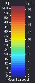
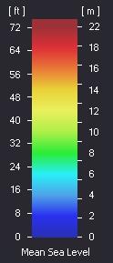
4 CERA Storm Surge Features Model output: Water elevation (storm surge) Water inundation above ground Wind speed Significant wave height Relative peak wave ADCIRC node attributes Hurricane track information Overlay features: ADCIRC grid barriers NOAA shoreline Background maps: Google Road Map Satellite Terrain Zoomable maps Animations

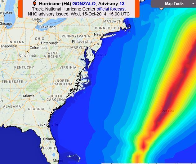
5 CERA Northern Gulf

6 Predict Flooding KNOWLEDGE TRANSFER CONTROL ADCIRC ASGS CERA Combines atmospheric pressure and wind forecasts to predict when, where and to what extent flooding will inundate a coastal community uses ADCIRC and thousands of supercomputers to generate storm surge guidance in real time for approaching hurricanes enables decision makers to identify which locations to evacuate and to plan for mitigation and response before severe storms occur INFORMATION Global, Regional, Local


7 CERA is a TECHNOLOGY Vision credit: Jason Fleming, Seahorse Coastal Consulting ADCIRC Surge Guidance System (ASGS)

8 Batch Queue Prediction Time TERAGRID

9 Breton Sound Monitoring Stations

10 Louisiana Virtual Coast


11 Wax Lake Delta Case Study The Wax Lake Delta Case Study compares the CLEAR landscape change module (Visser et al. 2008) to the geoengineering model developed by Parker and Sequiros (2006) Both models are used to investigate delta building dynamics considering different sediment loads within the Wax Lake Outlet.

12 Near Shore Oil Spill Particle Tracking

13 Coupled SWAN + ADCIRC model

14 Deep Water Horizon Oil Spill Response

15 Deep Water Horizon Oil Spill Response
16 Open GIS Consortium (OGC) Standards WMS OGC Web Map Service Interface Standard Provides map images of selected data layers in raster formats (PNG, GIF, JPEG, TIFF) WFS - OGC Web Feature Service Interface Standard Provides vector source data (points, lines, polygons) in Geography Markup Language (GML) format.
17 Why using OGC standards? Ability to use geographic data and layers from other map servers. In this case, the application becomes a WMS (or WFS) client. Share (or serve up) geographic layers to other map servers. This makes an application a WMS (or WFS) server.
18 STORM YEAR 1 - Shapefiles Will replace the TIFF imagery files used in CERA Direct download from each CERA page see what you get Allows the GIS community to work with shapefiles in ArcGIS Allows flexible color scales Speed? not necessarily better than TIFs


19 STORM YEAR 1 - Shapefiles Better readability for ADCIRC results with a narrow range of values


20 STORM YEAR 1 - Shapefiles Better differentiation for daily ADCIRC runs

21 STORM YEAR 1 - Shapefiles Faster assessment of critical storm situations

 Display the")

22 STORM YEAR 1 - Shapefiles CERA Casey Dietrich (UNC) Display the downloaded data in ArcGIS with pre-defined color files
23 STORM YEAR 1 - CERA VIEWER Northern Gulf Coastal Hazards Collaboratory (NG- CHC) Robert Twilley ( ) First version for STORM: 1. Data on local hard drive 2. Local web browser 3. Netcdf format with included mesh information 4. No sharing or download
![Usage: cera_viewer.py [path_to_your_adcirc_netcdf_file] 1.](/docs-images/73/69473746/images/24-0.jpg "Creates a shapefile from the netcdf file 2.")
24 Usage: cera_viewer.py [path_to_your_adcirc_netcdf_file] 1. Creates a shapefile from the netcdf file 2. Opens a local web browser
Forecast Predictions of Winds, Waves and Storm Surge during Hurricane Arthur (2014)
") Forecast Predictions of Winds, Waves and Storm Surge during Hurricane Arthur (2014) R Cyriac 1, JC Dietrich 1, JG Fleming 2, BO Blanton 3, RA Luettich Jr 4, C Kaiser 5 1 Dept. of Civil, Construction, and
Forecast Predictions of Winds, Waves and Storm Surge during Hurricane Arthur (2014) R Cyriac 1, JC Dietrich 1, JG Fleming 2, BO Blanton 3, RA Luettich Jr 4, C Kaiser 5 1 Dept. of Civil, Construction, and
CERA-Atlantic Storm Surge Web Page: Improvements for 2013 Based on EM Feedback
 CERA-Atlantic Storm Surge Web Page: Improvements for 2013 Based on EM Feedback Jessica Losego Meteorologist University of North Carolina - Institute for the Environment Rick Luettich Director, UNC IMS
Coastal Emergency Risks Assessment - CERA Real-Time Storm Surge and Wave Visualization Tool
 Coastal Emergency Risks Assessment - CERA Real-Time Storm Surge and Wave Visualization Tool Introduction This document provides guidance for using the Coastal Emergency Risks Assessment (CERA) visualization
HFIP- Supported Improvements to Storm Surge Forecas6ng in 2012
 HFIP- Supported Improvements to Storm Surge Forecas6ng in 2012 Jesse C. Feyen (NOS/OCS), Jamie Rhome (NWS/NHC), Rick LueJch (UNC- CH), Jason Fleming (Seahorse Consul6ng), Brian Blanton (RENCI), Yuji Funakoshi
RHOAPS. Real-time Hydrology Ocean Atmosphere Prediction System. Pronunciation: Ropes Motto: More than just THREDDS
 RHOAPS Real-time Hydrology Ocean Atmosphere Prediction System Pronunciation: Ropes Motto: More than just THREDDS Key Aspects Integrated real-time data systems Atmospheric Hydrologic Coastal oceans Societal
5A.10 A GEOSPATIAL DATABASE AND CLIMATOLOGY OF SEVERE WEATHER DATA
 5A.10 A GEOSPATIAL DATABASE AND CLIMATOLOGY OF SEVERE WEATHER DATA Steve Ansari * and Stephen Del Greco NOAA National Climatic Data Center, Asheville, North Carolina Mark Phillips University of North Carolina
Geoprovisioning delivers geodata and its analysis for specific areas on request.
 DRAFT 27 February 2009 Geoprovisioning Geoprovisioning delivers geodata and its analysis for specific areas on request. What are the components of a geoprovisioning service? The sample web site geoprovisioning.com
A multi-tiered ADCIRC-based storm surge and wave prediction system
 A multi-tiered ADCIRC-based storm surge and wave prediction system Brian Blanton, Renaissance Computing Institute, UNC-Chapel Hill Rick Luettich, Institute of Marine Sciences, UNC-Chapel Hill, co-pi Jason
Reprint of article that appeared in Hydro INTERNATIONAL November 2006 Volume 10 Issue 9
 Reprint of article that appeared in Hydro INTERNATIONAL November 2006 Volume 10 Issue 9 While Google Earth is the best known 3D web-mapping viewer currently in the public domain, there are alternative
IMPLEMENTING GOVERNMENT-WIDE ENTERPRISE GIS; THE FEDERATED MODEL
 IMPLEMENTING GOVERNMENT-WIDE ENTERPRISE GIS; THE FEDERATED MODEL James E. Mitchell, Ph. D. IT GIS Manager Louisiana Department of Transportation and Development presented at the ESRI International Users
A Temporal Hydrologic Database for Rapidly Changing Landscapes
 A Temporal Hydrologic Database for Rapidly Changing Landscapes Using Mt. St. Helens in Washington as a Pilot Site Adam Mosbrucker Geog 575 BACKGROUND: Client / User U.S. Geological Survey Cascades Volcano
A Cloud-Based Flood Warning System For Forecasting Impacts to Transportation Infrastructure Systems
 A Cloud-Based Flood Warning System For Forecasting Impacts to Transportation Infrastructure Systems Jon Goodall Associate Professor, Civil and Environmental Engineering Associate Director, Link Lab April
Simulation of storm surge and overland flows using geographical information system applications
 Coastal Processes 97 Simulation of storm surge and overland flows using geographical information system applications S. Aliabadi, M. Akbar & R. Patel Northrop Grumman Center for High Performance Computing
Climate Data for Non-experts: Standards-based Interoperability
 Climate Data for Non-experts: Standards-based Interoperability Ben Domenico Unidata Program Center University Corporation for Atmospheric Research April 2010 Working Together on A Mosaic for Atmospheric
Use of Satellite Earth Observations, in situ data and numerical model capabilities for oil spill contingency. Page 1
 Use of Satellite Earth Observations, in situ data and numerical model capabilities for oil spill contingency Page 1 Oil spill service Page 2 Interest of Earth-Observation (EO) data for oil and gas companies
Geoprocessing Hydrometeorological Datasets to Assess National Weather Service (NWS) Forecasts
 Forecasts") Geoprocessing Hydrometeorological Datasets to Assess National Weather Service (NWS) Forecasts Jack Settelmaier National Weather Service Southern Region HQ Fort Worth, Texas ABSTRACT The National Weather
Geoprocessing Hydrometeorological Datasets to Assess National Weather Service (NWS) Forecasts Jack Settelmaier National Weather Service Southern Region HQ Fort Worth, Texas ABSTRACT The National Weather
ArcGIS Web Tools, Templates, and Solutions for Defence & Intelligence. Renee Bernstein Esri Solutions Engineer
 ArcGIS Web Tools, Templates, and Solutions for Defence & Intelligence Renee Bernstein Esri Solutions Engineer ArcGIS Solutions Includes 450+ Industry Focused Apps and Capabilities Organized by 9 Primary
Urgent Computing for Hurricane Forecasts
 Urgent Computing for Hurricane Forecasts Gabrielle Allen Center for Computation & Technology Dept Computer Science Louisiana State University gallen@cct.lsu.edu Representing the SURA Coastal Ocean Observing
Web 3D Service & CityGML Update
 Technische Universität Berlin Web 3D Service & CityGML Update Thomas H. Kolbe Institute for Geodesy and Geoinformation Science Berlin University of Technology kolbe@igg.tu-berlin.de 2nd of November, 2007
Experimental Probabilistic Hurricane Inundation Surge Height (PHISH) Guidance
 Guidance") Experimental Probabilistic Hurricane Inundation Surge Height (PHISH) Guidance DRBC Flood Advisory Committee John Kuhn - NWS/OCWWS Anne Myckow (NWS/MDL), Arthur Taylor (NWS/MDL) SLOSH Sea, Lake and Overland
Experimental Probabilistic Hurricane Inundation Surge Height (PHISH) Guidance DRBC Flood Advisory Committee John Kuhn - NWS/OCWWS Anne Myckow (NWS/MDL), Arthur Taylor (NWS/MDL) SLOSH Sea, Lake and Overland
E x a m p l e s o f t o o l s f o r s e a s i t u a t i o n a l a w a r e n e s s u s i n g C M E M S d a t a. Copernicus EU
 E x a m p l e s o f t o o l s f o r s e a s i t u a t i o n a l a w a r e n e s s u s i n g C M E M S d a t a Copernicus EU Copernicus EU Copernicus EU www.copernicus.eu S e a S i t u a t i o n a l A w
Leon Creek Watershed October 17-18, 1998 Rainfall Analysis Examination of USGS Gauge Helotes Creek at Helotes, Texas
 Leon Creek Watershed October 17-18, 1998 Rainfall Analysis Examination of USGS Gauge 8181400 Helotes Creek at Helotes, Texas Terrance Jackson MSCE Candidate University of Texas San Antonio Abstract The
Climate Risk Visualization for Adaptation Planning and Emergency Response
 Climate Risk Visualization for Adaptation Planning and Emergency Response NCR Flood Fact Finding Workshop Ricardo Saavedra ricardo@vizonomy.com Social Media, Mobile, and Big Data St. Peter s Basilica,
An Integrated Storm Surge, Hurricane Wave, Salinity and Sediment Transport Modeling System for Breton Sound, LA
 An Integrated Storm Surge, Hurricane Wave, Salinity and Sediment Transport Modeling System for Breton Sound, LA Q. Jim Chen Department of Civil and Environmental Engineering qchen@lsu.edu Acknowledgements
Calhoun County, Texas Under 5 Meter Sea Level Rise
 Kyle Kacal GEO 327G Calhoun County, Texas Under 5 Meter Sea Level Rise PROBLEM AND PURPOSE: Sea level rise is threat to all coastal areas. Although natural sea level rise happens at a very slow rate, hurricanes
Data Aggregation with InfraWorks and ArcGIS for Visualization, Analysis, and Planning
 Data Aggregation with InfraWorks and ArcGIS for Visualization, Analysis, and Planning Stephen Brockwell President, Brockwell IT Consulting, Inc. Join the conversation #AU2017 KEYWORD Class Summary Silos
USACE-ERDC Coastal Storm Modeling System Updates Chris Massey, PhD
 USACE-ERDC Coastal Storm Modeling System Updates Chris Massey, PhD Research Mathematician USACE-ERDC Coastal & Hydraulics Lab Chris.Massey@usace.army.mil ERDC s Coastal Storm-Modeling System (ERDC CSTORM-MS)
an accessible interface to marine environmental data Russell Moffitt
 an accessible interface to marine environmental data Russell Moffitt The Atlas Project GOAL: To provide a single point of access to oceanographic and environmental data for use by marine resource researchers,
HURRICANE MATTHEW A GIS PERSPECTIVE GLYNN COUNTY GIS
 HURRICANE MATTHEW A GIS PERSPECTIVE GLYNN COUNTY GIS Situation September 25 th October 9 th 2016 Hurricane Matthew tracked its way up the east coast bringing hurricane force winds and flooding from Haiti
Application of high-resolution (10 m) DEM on Flood Disaster in 3D-GIS
 DEM on Flood Disaster in 3D-GIS") Risk Analysis V: Simulation and Hazard Mitigation 263 Application of high-resolution (10 m) DEM on Flood Disaster in 3D-GIS M. Mori Department of Information and Computer Science, Kinki University, Japan
Risk Analysis V: Simulation and Hazard Mitigation 263 Application of high-resolution (10 m) DEM on Flood Disaster in 3D-GIS M. Mori Department of Information and Computer Science, Kinki University, Japan
The next generation in weather radar software.
 The next generation in weather radar software. PUBLISHED BY Vaisala Oyj Phone (int.): +358 9 8949 1 P.O. Box 26 Fax: +358 9 8949 2227 FI-00421 Helsinki Finland Try IRIS Focus at iris.vaisala.com. Vaisala
Coast Survey Providing Improved Access to Maritime Navigation Products and Services
 Coast Survey Providing Improved Access to Maritime Navigation Products and Services Kurt A. Nelson, Branch Chief CGTP Leland Snyder, Branch Chief FADS Office of Coast Survey Agenda Current Coast Survey
WEB MAP SERVICE (WMS) FOR GEOLOGICAL DATA GEORGE TUDOR
 FOR GEOLOGICAL DATA GEORGE TUDOR") WEB MAP SERVICE (WMS) FOR GEOLOGICAL DATA GEORGE TUDOR WEB MAP SERVICE (WMS) - GENERALITIES Projects with data from different sources Geological data are in different GIS software format Large amount of
WEB MAP SERVICE (WMS) FOR GEOLOGICAL DATA GEORGE TUDOR WEB MAP SERVICE (WMS) - GENERALITIES Projects with data from different sources Geological data are in different GIS software format Large amount of
Hurricane Season 2010 & NOAA s Deepwater Response
 Hurricane Season 2010 & NOAA s Deepwater Response What s Happened? What Will 2010 Bring? Possible Shoreline Effects Darin Figurskey Meteorologist-in-Charge NOAA s NWS Raleigh, NC NOAA s National Weather
Finnish Open Data Portal for Meteorological Data
 18.11.2013 1 Finnish Open Data Portal for Meteorological Data 14th Workshop on meteorological operational systems Roope Tervo Finnish Meteorological Institute Example of Data Sets -- Observations Data
Esri UC Talking Points. Harmful Algae Blooms (HABs) Rapid growth, blooming of toxin producing algae
 Rapid growth, blooming of toxin producing algae") Esri UC Talking Points Harmful Algae Blooms (HABs) Rapid growth, blooming of toxin producing algae They exist on every coast Freshwater and marine species Commented [1]: Combine for talk HAB-OFS produces
Esri UC Talking Points Harmful Algae Blooms (HABs) Rapid growth, blooming of toxin producing algae They exist on every coast Freshwater and marine species Commented [1]: Combine for talk HAB-OFS produces
Guide to Hydrologic Information on the Web
 NOAA s National Weather Service Guide to Hydrologic Information on the Web Colorado River at Lees Ferry Photo: courtesy Tim Helble Your gateway to web resources provided through NOAA s Advanced Hydrologic
GIS-based Smart Campus System using 3D Modeling
 GIS-based Smart Campus System using 3D Modeling Smita Sengupta GISE Advance Research Lab. IIT Bombay, Powai Mumbai 400 076, India smitas@cse.iitb.ac.in Concept of Smart Campus System Overview of IITB Campus
Assessing the Robustness of Web Feature Services Necessary to Satisfy the Requirements of Coastal Management
 Assessing the Robustness of Web Feature Services Necessary to Satisfy the Requirements of Coastal Management Jennifer Bauer M.S. Geography GISci Certificate June 4, 2012 Presentation Outline!! Background
GIS-based Smart Campus System using 3D Modeling
 GIS-based Smart Campus System using 3D Modeling Hardik Panchal & Rizwan Khan, Smita Sengupta, GISE Advance Lab, Indian Institute of Technology, Bombay, India N.L. Sarda, Dept. Of Computer Science, Indian
GIS in Weather and Society
 GIS in Weather and Society Olga Wilhelmi Institute for the Study of Society and Environment National Center for Atmospheric Research WAS*IS November 8, 2005 Boulder, Colorado Presentation Outline GIS basic
HURREVAC The software Tool used by emergency officials for hurricane evacuation assistance
 HURREVAC 2010 A Quick Reference enc e Guide The software Tool used by emergency officials for hurricane evacuation assistance www.hurrevac.com FinalHURREVAC2010Guide.indd 1 About HURREVAC HURREVAC is a
Developing 3D Geoportal for Wilayah Persekutuan Iskandar
 Developing 3D Geoportal for Wilayah Persekutuan Iskandar Dionnald Beh BoonHeng and Alias Abdul Rahman Department of Geoinformatics, Faculty of Geoinformation Engineering and Sciences, Universiti Teknologi
Visualizing hurricanes
 Visualizing hurricanes NAME: DATE: Scientific visualization is an integral part of the process of simulating natural phenomena. In the computational sciences, the main goal is to understand the workings
COASTAL DATA APPLICATION
 2015 Coastal GeoTools Proactive By Design. Our Company Commitment COASTAL DATA APPLICATION Projecting Future Coastal Flood Risk for Massachusetts Bay Bin Wang, Tianyi Liu, Daniel Stapleton & Michael Mobile
Features and Benefits
 Autodesk LandXplorer Features and Benefits Use the Autodesk LandXplorer software family to help improve decision making, lower costs, view and share changes, and avoid the expense of creating physical
Geospatial Fire Behavior Modeling App to Manage Wildfire Risk Online. Kenyatta BaRaKa Jackson US Forest Service - Consultant
 Geospatial Fire Behavior Modeling App to Manage Wildfire Risk Online Kenyatta BaRaKa Jackson US Forest Service - Consultant Fire Behavior Modeling and Forest Fuel Management Modeling Fire Behavior is an
Conceptual Modelling within The OGC MetOcean Domain Working Group
 Conceptual Modelling within The OGC MetOcean Domain Working Group 21 st EGOWS Mtg, 1 st -4 th June 2010, ECMWF Dominic Lowe, dominiclowe@stfc.ac.uk British Atmospheric Data Centre, http://badc.nerc.ac.uk
13.2 USING VIRTUAL GLOBES TO IMPROVE SITUATIONAL AWARENESS IN THE NATIONAL WEATHER SERVICE
 13.2 USING VIRTUAL GLOBES TO IMPROVE SITUATIONAL AWARENESS IN THE NATIONAL WEATHER SERVICE Andy Foster* National Weather Service Springfield, Missouri* Keith Stellman National Weather Service Shreveport,
Web-GIS based Framework for Solid Waste Complaint Management for Sustainable and Smart City
 Cloud Publications International Journal of Advanced Remote Sensing and GIS 2016, Volume 5, Issue 10, pp. 1930-1936 ISSN 2320-0243, DOI: 10.23953/cloud.ijarsg.71 Research Article Open Access Web-GIS based
THC-T-2013 Conference & Exhibition
 Modeling of Shutter Coastal Protection against Storm Surge for Galveston Bay C. Vipulanandan, Ph.D., P.E., Y. Jeannot Ahossin Guezo and and B. Basirat Texas Hurricane Center for Innovative Technology (THC-IT)
Add NOAA nowcoast Layers to Maps
 WebEOC Maps Add-on Quick Reference Guide Add NOAA nowcoast Layers to Maps Overview With Maps Add-on, you can configure an unlimited number of map layers. These layers allow you to control the data you
General background on storm surge. Pat Fitzpatrick and Yee Lau Mississippi State University
 General background on storm surge Pat Fitzpatrick and Yee Lau Mississippi State University Storm surge is an abnormal rise of water associated with a cyclone, not including tidal influences Low pressure
Storm Surge Analysis Update Meeting Cross City, Florida June 17, 2014
 Big Bend Coastal Storm Surge Study Storm Surge Analysis Update Meeting Cross City, Florida June 17, 2014 Introductions Risk MAP Project Team FEMA Region IV Florida Division of Emergency Management (FDEM)
EnvSci 360 Computer and Analytical Cartography
 EnvSci 360 Computer and Analytical Cartography Lecture 7 Mapping Images, Surfaces, and 3-D Data Brief Overview of Imagery What is Imagery? A spatial data model that defines space as an array of equally
Overview of the Tropical Cyclone Guidance Project
 Overview of the Tropical Cyclone Guidance Project Dr. Jonathan L. Vigh With thanks to Mahsa Mirzargar (Univ. of Miami) Shanghai Typhoon Institute 09 July 2018 NCAR is sponsored by the National Science
Frank Revitte National Weather Service. Weather Forecast Office New Orleans/Baton Rouge
 Frank Revitte National Weather Service Weather Forecast Office New Orleans/Baton Rouge Above normal activity 17 Total Named Storms 7 Tropical Storms 4 Hurricanes 6 Major Hurricanes Not the most active,
What s new in GIS. RAL Retreat Oct 5, 2005
 What s new in GIS RAL Retreat Oct 5, 2005 Overview GIS Initiative milestones Major activities in 2004-2005 GALEON UNIDATA OGC project New functionality in ESRI software GIS Initiative Team Olga Wilhelmi
NORTH ATLANTIC COAST COMPREHENSIVE STUDY (NACCS) STORM MODELING AND STATISTICAL ANALYSIS FOR
 STORM MODELING AND STATISTICAL ANALYSIS FOR") NORTH ATLANTIC COAST COMPREHENSIVE STUDY (NACCS) STORM MODELING AND STATISTICAL ANALYSIS FOR 237 237 217 217 200 200 80 27 252 174.59 COMPUTING 255 0 163 COASTAL 131 239 110 HAZARDS 112 62 255 255 0 0
NORTH ATLANTIC COAST COMPREHENSIVE STUDY (NACCS) STORM MODELING AND STATISTICAL ANALYSIS FOR 237 237 217 217 200 200 80 27 252 174.59 COMPUTING 255 0 163 COASTAL 131 239 110 HAZARDS 112 62 255 255 0 0
Hindcast Arabian Gulf
 Hindcast Arabian Gulf Image of isobars of atmospheric pressure and hindcast wind- and wave field over the Arabian Gulf during a storm in January 1993. Detailed wave studies are supported by nesting of
What s New in Topographic Information - USGS National Map
 + What s New in Topographic Information - USGS National Map SARGIS Workshop November 14, 2016 Rob Dollison, 703-648-5724 rdollison@usgs.gov + USGS 2 National Geospatial Program The National Geospatial
Complete Weather Intelligence for Public Safety from DTN
 Complete Weather Intelligence for Public Safety from DTN September 2017 White Paper www.dtn.com / 1.800.610.0777 From flooding to tornados to severe winter storms, the threats to public safety from weather-related
Geospatial Products V8i (SELECTseries 1)
") Geospatial Products V8i (SELECTseries 1) Keith Raymond Product Manager Geospatial Desktop Products Presentation Overview What are the various products? Why would you need them? Demonstrations 2 WWW.BENTLEY.COM
Geospatial Products V8i (SELECTseries 1) Keith Raymond Product Manager Geospatial Desktop Products Presentation Overview What are the various products? Why would you need them? Demonstrations 2 WWW.BENTLEY.COM
John Callahan (Delaware Geological Survey) Kevin Brinson, Daniel Leathers, Linden Wolf (Delaware Environmental Observing System)
 Kevin Brinson, Daniel Leathers, Linden Wolf (Delaware Environmental Observing System)") John Callahan (Delaware Geological Survey) Kevin Brinson, Daniel Leathers, Linden Wolf (Delaware Environmental Observing System) Delaware is extremely vulnerable to the impacts of coastal flooding Tropical
John Callahan (Delaware Geological Survey) Kevin Brinson, Daniel Leathers, Linden Wolf (Delaware Environmental Observing System) Delaware is extremely vulnerable to the impacts of coastal flooding Tropical
The Northeast Coastal Ocean Forecast System (NECOFS) and Storm Surge and Inundation Prediction. Status and Initial Ideas
 and Storm Surge and Inundation Prediction. Status and Initial Ideas") The Northeast Coastal Ocean Forecast System (NECOFS) and Storm Surge and Inundation Prediction Status and Initial Ideas Changsheng Chen (UMassD) and Bob Beardsley (WHOI) Website: http://fvcom.smast.umassd.edu
The Northeast Coastal Ocean Forecast System (NECOFS) and Storm Surge and Inundation Prediction Status and Initial Ideas Changsheng Chen (UMassD) and Bob Beardsley (WHOI) Website: http://fvcom.smast.umassd.edu
Modeling Storm Surge for Emergency Management
 Modeling Storm Surge for Emergency Management Study Area: Guam is the southern-most island of the Mariana Archipelago and is located at 13 28 N, 144 47 E. It has a total area of 541.3 sq. km. and the highest
baltrad Mass media Overview
 48 Mass media Overview Weather information disseminated through mass media, like press, TV, and Internet is intended for its recipients, not for the media themselves. Therefore the addressees of the media
Providing Public Access to King County GIS Data. Presented by: Michael Jenkins King County GIS Center Seattle, WA
 Providing Public Access to King County GIS Data Presented by: Michael Jenkins King County GIS Center Seattle, WA King County, Washington Microsoft Boeing Amazon.Com Starbucks Port of Seattle Weyerhauser
RSMC-Miami Update Daniel Brown Warning Coordination Meteorologist
 RSMC-Miami Update 2016 Daniel Brown Warning Coordination Meteorologist L-0324 Emergency Management Hurricane Preparedness Training Course Funding provided by FEMA s National Hurricane Program - partnership
The PREVIEW Global Risk Data Platform: a geoportal to serve and share global data on risk to natural hazards
 The PREVIEW Global Risk Data Platform: a geoportal to serve and share global data on risk to natural hazards Gregory Giuliani (UNEP/GRID-Geneva & University of Geneva/enviroSPACE ) http://www.grid.unep.ch
ICAN Great Lakes 2010 Workshop
 ICAN Great Lakes 2010 Workshop Chris Cortina Maryland s Chesapeake & Coastal Program MD Department of Natural Resources Maryland s Coastal Atlas: What is it? The Coastal Atlas is an online mapping and
Abstract: Contents. Literature review. 2 Methodology.. 2 Applications, results and discussion.. 2 Conclusions 12. Introduction
 Abstract: Landfill is one of the primary methods for municipal solid waste disposal. In order to reduce the environmental damage and to protect the public health and welfare, choosing the site for landfill
NWS 13: NetCDF Wind/Pressure Inputs for ADCIRC
 NWS 13: NetCDF Wind/Pressure Inputs for ADCIRC Alex Crosby Oceanweather Inc. Casey Dietrich NC State University 2018 ADCIRC User s Group Meeting Summary Motivation NetCDF Structure/Schema Implementation
SYNERGY OF SATELLITE REMOTE SENSING AND SENSOR NETWORKS ON GEO GRID
 SYNERGY OF SATELLITE REMOTE SENSING AND SENSOR NETWORKS ON GEO GRID National Institute of Advanced Industrial Science and Technology, Japan Yoshio Tanaka (on behalf of AIST GEO Grid team) Contents Brief
Draft for Discussion 11/11/2016
 Coastal Risk Consulting (CRC) Climate Vulnerability Assessment for Village of Key Biscayne Deliverable 1.1 in Statement of Work. Preliminary Vulnerability Assessment Identifying Flood Hotspots Introduction...
Computing the Joint Probability of Hurricane Sandy and Historical Coastal Storm Forcing Parameters from Maine to Virginia
 Computing the Joint Probability of Hurricane Sandy and Historical Coastal Storm Forcing Parameters from Maine to Virginia Chris Massey and Jeff Melby USACE-ERDC Coastal & Hydraulics Lab Chris.Massey@usace.army.mil
Storm Surge/Coastal Inundation State of the Union. Jamie Rhome Storm Surge Team Lead NOAA/National Hurricane Center
 Storm Surge/Coastal Inundation State of the Union Jamie Rhome Storm Surge Team Lead NOAA/National Hurricane Center 2 Tampa: Cat 5 Scenario 3 4 The Stakes are High Combination of SLR and increasing coastal
DP Project Development Pvt. Ltd.
 Dear Sir/Madam, Greetings!!! Thanks for contacting DP Project Development for your training requirement. DP Project Development is leading professional training provider in GIS technologies and GIS application
Implementing Extreme Value Analysis in a Geospatial Workflow for Assessing Storm Surge Hazards
 Implementing Extreme Value Analysis in a Geospatial Workflow for Assessing Storm Surge Hazards Jason Catelli The Pennsylvania State University Master of Geographic Information Systems Capstone Project
National Climatic Data Center Data Management Issues Tom Karl Director, NOAA s National Climatic Data Center
 National Climatic Data Center Data Management Issues Tom Karl Director, NOAA s National Climatic Data Center Opening Meeting NOAA Science Advisory Board s Data Archiving and Access Requirements Working
Questions and Answers
 AUTODESK LANDXPLORER SOFTWARE FAMILY Questions and Answers The Autodesk LandXplorer 3D city model software family can help you create, analyze, and visualize digital city models. Contents Autodesk Landxplorer
Mapping Coastal Change Using LiDAR and Multispectral Imagery
 Mapping Coastal Change Using LiDAR and Multispectral Imagery Contributor: Patrick Collins, Technical Solutions Engineer Presented by TABLE OF CONTENTS Introduction... 1 Coastal Change... 1 Mapping Coastal
Coastal Hazard Assessment for the Lowermost Mississippi River Management Program
 Coastal Hazard Assessment for the Lowermost Mississippi River Management Program USACE ERDC Coastal and Hydraulics Laboratory Mary Cialone Chris Massey Norberto Nadal USACE Mississippi Valley Division
Linkage to the National Program
 Linkage to the National Program Frank González Pacific Marine Environmental Laboratory Seattle, WA Frank González, NOAA TIME Center, PMEL, Seattle, WA NOAA is about FORECASTS and WARNINGS -Hurricanes Sunspots
Applications: Introduction Task 1: Introduction to ArcCatalog Task 2: Introduction to ArcMap Challenge Question References
 CHAPTER 1 INTRODUCTION 1.1 GIS? 1.1.1 Components of a GIS 1.1.2 A Brief History of GIS 1.1.3 GIS Software Products Box 1.1 A List of GIS Software Producers and Their Main Products 1.2 GIS Applications
2017 Hurricane Season and Beyond
 2017 Hurricane Season and Beyond Ken Graham National Hurricane Center Building a Weather-Ready Nation Much of U.S. Coast Saw Tropical Wind Watches or Warnings 2017 Hurricane Season Facts and Figures 7th
4B.8 ACCESSING GEOGRAPHIC INFORMATION SERVICES AND VISUALIZATION PRODUCTS AT NOAA S NATIONAL CLIMATIC DATA CENTER
 4B.8 ACCESSING GEOGRAPHIC INFORMATION SERVICES AND VISUALIZATION PRODUCTS AT NOAA S NATIONAL CLIMATIC DATA CENTER Rich Baldwin *, Steve Ansari, and Neal Lott NOAA National Climatic Data Center, Asheville,
v WMS Tutorials GIS Module Importing, displaying, and converting shapefiles Required Components Time minutes
 v. 11.0 WMS 11.0 Tutorial Importing, displaying, and converting shapefiles Objectives This tutorial demonstrates how to import GIS data, visualize it, and convert it into WMS coverage data that could be
ENV208/ENV508 Applied GIS. Week 1: What is GIS?
 ENV208/ENV508 Applied GIS Week 1: What is GIS? 1 WHAT IS GIS? A GIS integrates hardware, software, and data for capturing, managing, analyzing, and displaying all forms of geographically referenced information.
ERDC S COASTAL STORM MODELING SYSTEM (AND APPLICATIONS)
") ERDC S COASTAL STORM MODELING SYSTEM (AND APPLICATIONS) Chris Massey Research Mathematician, USACE-ERDC Coastal & Hydraulics Lab Chris.Massey@usace.army.mil November 1-2, 2017 Team Acknowledgements Hung
ERDC S COASTAL STORM MODELING SYSTEM (AND APPLICATIONS) Chris Massey Research Mathematician, USACE-ERDC Coastal & Hydraulics Lab Chris.Massey@usace.army.mil November 1-2, 2017 Team Acknowledgements Hung
New NASA Ocean Observations and Coastal Applications
 New NASA Ocean Observations and Coastal Applications Duane Armstrong Chief, Applied Science & Technology Project Office August 20, 2014 1 Outline NASA s new Earth Science Ocean Science Missions for 2014
Advances in Coastal Inundation Simulation Using Unstructured-Grid Coastal Ocean Models
 Advances in Coastal Inundation Simulation Using Unstructured-Grid Coastal Ocean Models Bob Beardsley (WHOI) Changsheng Chen (UMass-Dartmouth) Bob Weisberg (U. South Florida) Joannes Westerink (U. Notre
Northrop Grumman Concept Paper
 Northrop Grumman Concept Paper A Comprehensive Geospatial Web-based Solution for NWS Impact-based Decision Support Services Glenn Higgins April 10, 2014 Northrop Grumman Corporation Information Systems
Key Points Sharing fosters participation and collaboration Metadata has a big role in sharing Sharing is not always easy
 Sharing Resources Geoff Mortson esri, Inc. SDI Solutions Team Key Points Sharing fosters participation and collaboration Metadata has a big role in sharing Sharing is not always easy Data Sharing is Good
These modules are covered with a brief information and practical in ArcGIS Software and open source software also like QGIS, ILWIS.
 Online GIS Training and training modules covered are: 1. ArcGIS, Analysis, Fundamentals and Implementation 2. ArcGIS Web Data Sharing 3. ArcGIS for Desktop 4. ArcGIS for Server These modules are covered
Coastal Hazards System: Interpretation and Application
 Lessons Learned and Best Practices: Resilience of Coastal Infrastructure Hato Rey, PR March 8-9, 2017 Coastal Hazards System: Interpretation and Application Victor M. Gonzalez, P.E. Team: PI: Jeffrey A.
You are Building Your Organization s Geographic Knowledge
 You are Building Your Organization s Geographic Knowledge And Increasingly Making it Available Sharing Data Publishing Maps and Geo-Apps Developing Collaborative Approaches Citizens Knowledge Workers Analysts
StreamStats: Delivering Streamflow Information to the Public. By Kernell Ries
 StreamStats: Delivering Streamflow Information to the Public By Kernell Ries U.S. Department of the Interior U.S. Geological Survey MD-DE-DC District 410-238-4317 kries@usgs.gov StreamStats Web Application
SDI Standards at work
 SDI Standards at work Jan Juul Jensen Senior Technology Strategist Informi GIS Denmark Informi GIS Private held Limited Company Specialized in GIS 100+ employees HQ in Charlottenlund, Copenhagen Regional
Services for Inland Marine Data Integration. USGS Center for Integrated
 Services for Inland Marine Data Integration USGS Center for Integrated Data Analytics Outline GeoDataPortal Tools Coastal Use Cases Beach hhealth lthmodeling Distributed Rainfall Analysis for Integration