DEVELOPMENT OF AN INUNDATION FORECAST SYSTEM FOR MASSACHUSETTS COASTAL WATERS
|
|
|
- Jocelyn Davidson
- 5 years ago
- Views:
Transcription
1 DEVELOPMENT OF AN INUNDATION FORECAST SYSTEM FOR MASSACHUSETTS COASTAL WATERS C. Chen and R. C. Beardsley MITSG Sea Grant College Program Massachusetts Institute of Technology Cambridge, Massachusetts NOAA Grant No. NA10OAR Project No R/RC-127 Presented at Oceans Signal Climate Change - A Stakeholder Science Forum, MIT Sea Grant College Program, May 29, 2013.
2 Development of An Inundation Forecast System for Massachusetts Coastal Waters Changsheng Chen University of Massachusetts-Dartmouth, New Bedford, MA Robert C Beardsley Woods Hole Oceanographic Institution, Woods Hole, MA 02543
3 Develop an end to-end inundation model system for Massachusetts Coastal Water and demonstrate its forecast capability for extratropical nor easter storm and hurricane-induced coastal flooding. Objectives
4 Northeast Coastal Ocean Forecast System (NECOFS) Satellite SST Buoy Winds Insola2on Satellite SST, SSH Buoy or Survey T,S,U,V KEY Exis8ng Models NECOFS Data Products North American Meso- scale (NAM) Weather Model BC s Global- FVCOM Rdes, currents, T and S) Nested Local Weather Model (WRF) Heat Flux Wind Stress P-E U,V Regional FVCOM (GOM- FVCOM: km) Wind Stress Surface Wave Model (FVCOM- SWAVE) assimilation River discharges Groundwater MASS Coastal FVCOM (up to 10 m) U,V, Waves Langmuir Cells assimilation Mass Inunda8on Model Storm Surge (hurricanes, Nor easter) Products: Weather: winds, air temperature, air humidity, air pressure, heat flux, E- P Oceans: sea level, currents, T, S, wave heights, wave frequencies, icing Lands: inundaron areas 05/29/2013- MIT To Be Developed

")

")
")


5 Nested Enlarged view Enlarged view Nested (2-50 km) Global- FVCOM Nested Mass Bay (up to 10 m) GoM-FVCOM ( km) Scituate, MA (up to 10 m) Mass Coastal FVCOM (10 m-5 km) NECOFS Mul8- Nested Domains


6 Tide gauge staron The Test Site: Scituate, MA 44013
 December 26, 27, 28,")
7 Sequence (leh to right) of daily weather maps at 7 EST (12 GMT) December 26, 27, 28, 2010.
8 Barometric pressure Wind direcron Wind speed Significant wave height Wind vectors At #44013 Wind vectors at Scituate Harbor (SH) Wd Dr (deg) BP (mb) Hs (m) Wd Sp (m/s) NDBC SH NDBC SH NDBC SH NDBC Wind (m/s) NDBC Wind (m/s) SH Days (Dec. 2010)
9 Wind velocity Air pressure Significant wave height Peak wave period Surface air pressure (mb) Wind Velocity Vector (m/s) Peak wave period (sec) Significant wave height (m) Observed WRF Observed Simulated Observed Simulated Observed Simulated Dec Days (Dec. 2010) a b c d

 and")
 at")
10 Maps of surface wave height (m) and direc8on (arrows) at Dec GMT

11 The Predicted Inundation Areas

12 No waves With waves

13 The August 19 Hurricane Bob
14 The WRF + Hurricane Weather Model

15 Significant wave height
16 Distributions of the model-predicted and observed maximum water elevations at available coastal stations from Eastport, ME to Lewes (DE) during the time period of August 19-21, Blue line: observed; Green line: computed with no wave- current interacron; Orange line: computed for with wave- current interacron; Red line: Rdal elevaron.
17 Water Temperature Water velocity

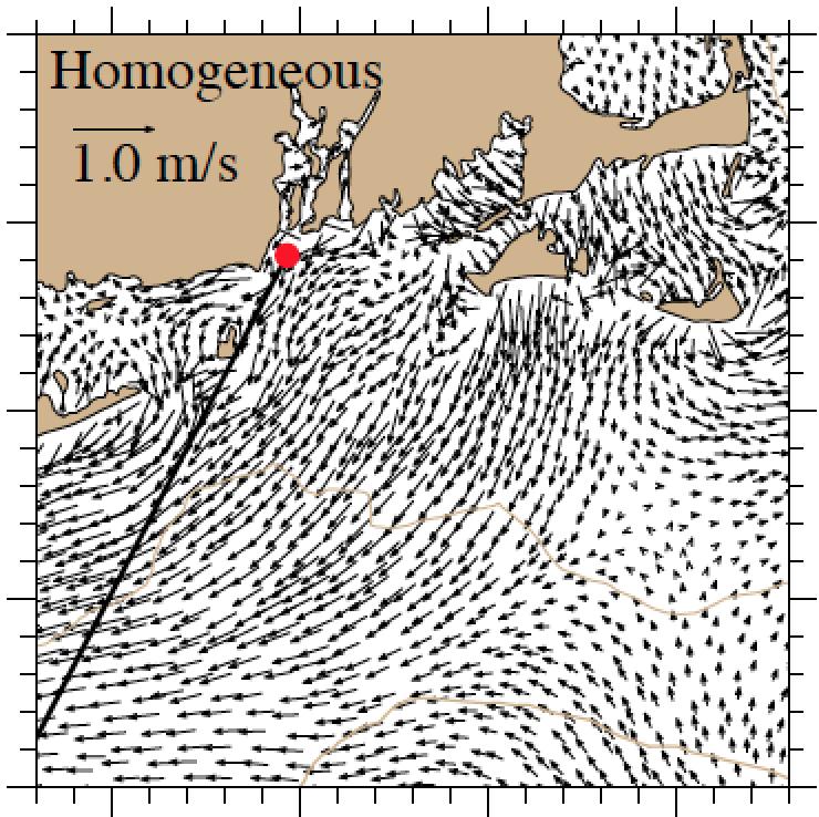
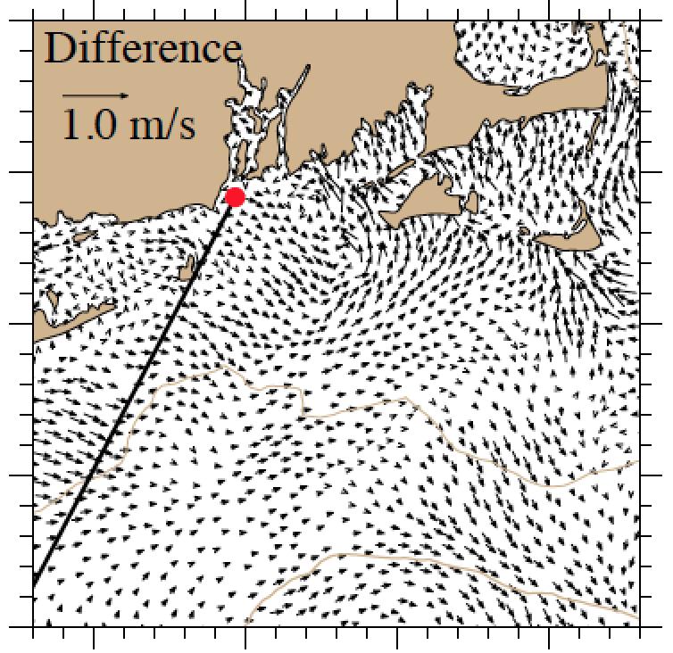
18 Near-bottom velocity distributions for stratified and homogeneous cases

19 h_p://porpoise1.smast.umassd.edu:8080/fvcomwms/

20 The February Blizzard Forecast The model-predicted total sea level at 10:00 AM EST on February 9, 2013 for the February 8-9 Blizzard. This prediction was made on February 7, 2013 and updated on February 8, 2013.
21 Future Challenge: Impacts of the Sea Level Rise ProjecRon of sea- level rise over based on the IPCC temperature projecron for three emission scenarios (B1, A2 and A1F1) (IPCC, 2007). Figure is downloaded from Vermeer and Rahmstorf (2009).


22 Bay of Fundy NEC MB
23 1. A fully current-wave coupled FVCOM inundation model system is capable of capturing the storm-induced sea level change and coastal inundation. 2. Wave- current interacron is crircally important, especially it could change the current direcron from the along- shelf direcron to the onshore direcron over the northern shelf, enlarging the onshore water transport 3. The system is ready to assess the impact of the climate change-induced sea level rise on the future storm inundation. 4. Spash-over (water driven by onshore winds and waves over the coastal sea walls) caused significant flooding. This process must be included in the future improvement of the inundation system. Summary
24 The MIT Sea Grant for the development of the Massachusetts inundation system and NERACOOS for the development and improvement of NECOFS. Sun, Y., C. Chen, R. C. Beardsley, Q. Xu, J. Qi and H. Lin, Impact of currentwave interaction on storm surge simulation: a case study for Hurricane Bob. Journal of Geophysical Research-Oceans, in press. Beardsley, R. C., C. Chen and Q. Xu, Coastal flooding in Scitute (MA): a FVCOM study of the Dec. 27, nor easter. Journal of Geophysical Research-Ocean, in revision. Chen, C. R. C. Beardsley, R. A Luettich Jr, J. J. Westerink, H. Wang, W. Perrie, Q. Xu, A. S. Dohahue, J. Qi, H. Lin, L. Zhao, P. Kerr, Y. Meng and B. Toulany, IOOS/SURA Extratropical Storm Inundation Testbed: Inter-model (ADCIRC, FVCOM and SELFE) comparisons in Scituate, Massachusetts. Journal of Geophysical Research-Ocean, in revision. Acknowledgment References
Impact of Sea Level Rise on Future Storm-induced Coastal Inundation
 Impact of Sea Level Rise on Future Storm-induced Coastal Inundation Changsheng Chen School for Marine Science and Technology, University of Massachusetts-Dartmouth Email: c1chen@umassd.edu 04/14/2015 Outline
NORTHEAST COASTAL OCEAN FORECAST SYSTEM (NECOFS)
") NORTHEAST COASTAL OCEAN FORECAST SYSTEM (NECOFS) R. C. Beardsley and C. Chen MITSG 13-27 Sea Grant College Program Massachusetts Institute of Technology Cambridge, Massachusetts 02139 NOAA Grant No. NA10OAR4170086
NORTHEAST COASTAL OCEAN FORECAST SYSTEM (NECOFS) R. C. Beardsley and C. Chen MITSG 13-27 Sea Grant College Program Massachusetts Institute of Technology Cambridge, Massachusetts 02139 NOAA Grant No. NA10OAR4170086
Critical Issues in Assessment of Offshore Wind Farm Development on Dispersion and Settling of Scallop Larvae in the Northeast U.S.
 Critical Issues in Assessment of Offshore Wind Farm Development on Dispersion and Settling of Scallop Larvae in the Northeast U.S. Coastal Ocean Changsheng Chen School for Marine Science and Technology
Advances in Coastal Inundation Simulation Using Unstructured-Grid Coastal Ocean Models
 Advances in Coastal Inundation Simulation Using Unstructured-Grid Coastal Ocean Models Bob Beardsley (WHOI) Changsheng Chen (UMass-Dartmouth) Bob Weisberg (U. South Florida) Joannes Westerink (U. Notre
Flood and Sea Level Rise Mapping Methodologies: The Way Forward
 Flood and Sea Level Rise Mapping Methodologies: The Way Forward Malcolm L. Spaulding Professor Emeritus, Ocean Engineering University of Rhode Island spaulding@egr.uri.edu Interagency Coordination Meeting
The Northeast Coastal Ocean Forecast System (NECOFS) and Storm Surge and Inundation Prediction. Status and Initial Ideas
 and Storm Surge and Inundation Prediction. Status and Initial Ideas") The Northeast Coastal Ocean Forecast System (NECOFS) and Storm Surge and Inundation Prediction Status and Initial Ideas Changsheng Chen (UMassD) and Bob Beardsley (WHOI) Website: http://fvcom.smast.umassd.edu
The Northeast Coastal Ocean Forecast System (NECOFS) and Storm Surge and Inundation Prediction Status and Initial Ideas Changsheng Chen (UMassD) and Bob Beardsley (WHOI) Website: http://fvcom.smast.umassd.edu
Coastal Cities-Coastal Impacts: 'The Tides They Are A-Changin
 Coastal Cities-Coastal Impacts: 'The Tides They Are A-Changin Susan K. Avery Woods Hole Oceanographic Institution Thanks to: Jeff Donnelly, Chris Reddy, Porter Hoagland, Jim Price, Dennis McGillicuddy,
COASTAL DATA APPLICATION
 2015 Coastal GeoTools Proactive By Design. Our Company Commitment COASTAL DATA APPLICATION Projecting Future Coastal Flood Risk for Massachusetts Bay Bin Wang, Tianyi Liu, Daniel Stapleton & Michael Mobile
Climate Adaptation Challenges for Boston s Water and Sewer Systems
 National Association of Flood & Stormwater Management Agencies Climate Adaptation Challenges for Boston s Water and Sewer Systems John P Sullivan P.E. October 15,2014 Boston 1630 Boston 1630-2012 Boston
J-Rapid PI: Jun Sasaki 1 T. Suzuki 1 and R. U. A. Wiyono 1. Rapid PI: Changsheng Chen 2 C. Beardsley 3, Z. Lai 2, R., H. Lin 2, J. Lin 3 and R.
 Collaborative Research: The Japan March 11 Earthquake: Tsunami inundation, and initial spread of Fukushima Dai-ichi Radionuclides into the Pacific Ocean: Model Assessment J-Rapid PI: Jun Sasaki 1 T. Suzuki
Impact of current-wave interaction on storm surge simulation: A case study for Hurricane Bob
 JOURNAL OF GEOPHYSICAL RESEARCH: OCEANS, VOL. 118, 2685 2701, doi:10.1002/jgrc.20207, 2013 Impact of current-wave interaction on storm surge simulation: A case study for Hurricane Bob Yunfang Sun, 1 Changsheng
Casco Bay Estuary Partnership (CBEP) USM Muskie School 34 Bedford St 228B. Portland, ME
 USM Muskie School 34 Bedford St 228B. Portland, ME") Casco Bay Estuary Partnership (CBEP) USM Muskie School 34 Bedford St 228B Wishcamper Center Portland, ME 04104 9300 Malcolm L. Spaulding Applied Science Associates 55 Village Square Drive South Kingstown,
Casco Bay Estuary Partnership (CBEP) USM Muskie School 34 Bedford St 228B Wishcamper Center Portland, ME 04104 9300 Malcolm L. Spaulding Applied Science Associates 55 Village Square Drive South Kingstown,
Saiful Islam Anisul Haque
 Workshop on Disaster Prevention/Mitigation Measures against Floods and Storm Surges in Bangladesh on 17-21 November, 2012, in Kyoto University, Japan Component 2: Flood disaster risk assessment and mitigation
Topics 1. IOOS on the US East Coast. 2. Regional Physical & Ecosystem Modeling Efforts
 Topics 1. IOOS on the US East Coast National Federation of Regional Associations http://usnfra.org - NERACOOS - MACOORA 2. Regional Physical & Ecosystem Modeling Efforts Northeast Regional Association
West Florida Shelf and Tampa Bay Responses to Hurricane Irma: What Happened and Why
 West Florida Shelf and Tampa Bay Responses to Hurricane Irma: What Happened and Why R.H. Weisberg Y. Liu J. Chen College of Marine Science University of South Florida St. Petersburg, FL SECOORA Webinar
Tampa Bay Storm Surge & Wave Vulnerability, Response to Hurricane Irma and Tools for Future Use
 Tampa Bay Storm Surge & Wave Vulnerability, Response to Hurricane Irma and Tools for Future Use Robert H. Weisberg with J. Chen, Y. Liu and L. Zheng College of Marine Science University of South Florida
Simulation of storm surge and overland flows using geographical information system applications
 Coastal Processes 97 Simulation of storm surge and overland flows using geographical information system applications S. Aliabadi, M. Akbar & R. Patel Northrop Grumman Center for High Performance Computing
An Unstructured Grid, Finite-Volume Coastal Ocean Model (FVCOM), Validations and Applications
, Validations and Applications") An Unstructured Grid, Finite-Volume Coastal Ocean Model (FVCOM), Validations and Applications Bob Beardsley, Changsheng Chen, and Geoff Cowles http://fvcom.smast.umassd.edu Data Assimilation in Support
An Unstructured Grid, Finite-Volume Coastal Ocean Model (FVCOM), Validations and Applications Bob Beardsley, Changsheng Chen, and Geoff Cowles http://fvcom.smast.umassd.edu Data Assimilation in Support
Agenda FVCOM Users Workshop Bedford Institute of Oceanography, Dartmouth October 20-22, Oral Program. Day 1: October 20
 Agenda FVCOM Users Workshop Bedford Institute of Oceanography, Dartmouth October 20-22, 2015 Oral Program 8:30 Registration Day 1: October 20 9:00 Welcome S. Haigh/D. Greenberg Session 1 C. Chen 9:10 A
USING MIKE TO MODEL COASTAL CATASTROPHE RISK
 USING MIKE TO MODEL COASTAL CATASTROPHE RISK Nicola Howe, Christopher Thomas, Joss Matthewman, John Maskell* 1 SUMMARY About RMS Who are we and what do we do? How do we use MIKE in our workflow? Case study:
PROJECT DESCRIPTION. 1. Introduction Problem Statement
 Salmun, H: A proposal submitted to PSC-CUNY program on October 15, 2009. Statistical prediction of storm surge associated with East Coast Cool-weather Storms at The Battery, New York. Principal Investigator:
HURRICANE - GENERATED OCEAN WAVES
 HURRICANE - GENERATED OCEAN WAVES Fumin Xu,, Will Perrie Bechara Toulany and Peter C Smith Fisheries and Oceans Canada, Bedford Institute of Oceanography, Dartmouth, NS, Canada College of Ocean Engineering,
Earth Observation in coastal zone MetOcean design criteria
 ESA Oil & Gas Workshop 2010 Earth Observation in coastal zone MetOcean design criteria Cees de Valk BMT ARGOSS Wind, wave and current design criteria geophysical process uncertainty modelling assumptions
A Dissertation. Presented to. The Faculty of the School of Marine Science. The College of William and Mary in Virginia. In Partial Fulfillment
 Developing an Unstructured Grid, Coupled Storm Surge, Wind Wave and Inundation Model for Super-regional Applications A Dissertation Presented to The Faculty of the School of Marine Science The College
The Field Research Facility, Duck, NC Warming Ocean Observations and Forecast of Effects
 The Field Research Facility, Duck, NC Warming Ocean Observations and Forecast of Effects A potential consequence of a warming ocean is more frequent and more intense wind events (Hurricanes & Typhoons)
WETLAND ESTUARINE SHELF INTERACTIONS IN THE PLUM ISLAND SOUND AND MERRIMACK RIVER IN THE MASSACHUSETTS COAST
 WETLAND ESTUARINE SHELF INTERACTIONS IN THE PLUM ISLAND SOUND AND MERRIMACK RIVER IN THE MASSACHUSETTS COAST L. Zhao, C. Chen, J. Vallino, C. Hopkinson, R. C. Beardsley, H. Lin and J. Lerczak MITSG 11-06
Field Research Facility
 Field Research Facility Sea Level Rise Observations of Sea Level rise Forces driving change Predicting future Sea Level rise Response of land surface Storm inundation coupled with Sea Level Dr. Jesse McNinch
An Integrated Storm Surge, Hurricane Wave, Salinity and Sediment Transport Modeling System for Breton Sound, LA
 An Integrated Storm Surge, Hurricane Wave, Salinity and Sediment Transport Modeling System for Breton Sound, LA Q. Jim Chen Department of Civil and Environmental Engineering qchen@lsu.edu Acknowledgements
The Massachusetts Bay Hydrodynamic Model: 2005 Simulation
 The Massachusetts Bay Hydrodynamic Model: 2005 Simulation Massachusetts Water Resources Authority Environmental Quality Department Report ENQUAD 2008-12 Jiang MS, Zhou M. 2008. The Massachusetts Bay Hydrodynamic
Boston Coastal Flooding Analysis and Mapping
 Boston Coastal Flooding Analysis and Mapping Philip Orton, Dara Mendeloff, Jane Mills, Malgosia Madajewicz Funding This research was funded by the National Oceanic and Atmospheric Administration (NOAA)
Building a fixed coastal observing and forecast system for Halifax Harbour
 Building a fixed coastal observing and forecast system for Halifax Harbour Jinyu Sheng 1 and Will Perrie 2 1 Department o Oceanography, Dalhousie University 2 Bedford InsEtute of Oceanography, DFO Research
PREDICTING TROPICAL CYCLONE FORERUNNER SURGE. Abstract
 PREDICTING TROPICAL CYCLONE FORERUNNER SURGE Yi Liu 1 and Jennifer L. Irish 1 Abstract In 2008 during Hurricane Ike, a 2-m forerunner surge, early surge arrival before tropical cyclone landfall, flooded
North Atlantic Coast Comprehensive Study (NACCS) APPENDIX A: ENGINEERING
 APPENDIX A: ENGINEERING") North Atlantic Coast Comprehensive Study (NACCS) APPENDIX A: ENGINEERING NORTH ATLANTIC COAST COMPREHENSIVE STUDY: RESILIENT ADAPTATION TO INCREASING RISK Appendix A - Engineering Table of Contents North
North Atlantic Coast Comprehensive Study (NACCS) APPENDIX A: ENGINEERING NORTH ATLANTIC COAST COMPREHENSIVE STUDY: RESILIENT ADAPTATION TO INCREASING RISK Appendix A - Engineering Table of Contents North
Operational Estuarine & Coastal Forecast Systems in NOAA s. National Ocean Service
 Operational Estuarine & Coastal Forecast Systems in NOAA s. National Ocean Service Eugene Wei, Frank Aikman III and Richard Patchen NOAA S S National Ocean Service Workshop on: Data Assimilation in Support
HURRICANE FRANCES CHARACTERISTICS and STORM TIDE EVALUATION
 HURRICANE FRANCES CHARACTERISTICS and STORM TIDE EVALUATION ((DRAFT)) By Robert Wang and Michael Manausa Sponsored by Florida Department of Environmental Protection, Bureau of Beaches and Coastal Systems
Adapting NEMO for use as the UK operational storm surge forecasting model
 Adapting NEMO for use as the UK operational storm surge forecasting model Rachel Furner 1, Jane Williams 2, Kevin Horsburgh 2, Andy Saulter 1 1; Met Office 2; NOC Table of Contents Existing CS3 model Developments
Research of the Influential Factors on the Simulation of Storm Surge in the Bohai Sea
 Send Orders for Reprints to reprints@benthamscience.net The Open Mechanical Engineering Journal, 2014, 8, 151-156 151 Open Access Research of the Influential Factors on the Simulation of Storm Surge in
Forecast of Nearshore Wave Parameters Using MIKE-21 Spectral Wave Model
 Forecast of Nearshore Wave Parameters Using MIKE-21 Spectral Wave Model Felix Jose 1 and Gregory W. Stone 2 1 Coastal Studies Institute, Louisiana State University, Baton Rouge, LA 70803 2 Coastal Studies
Benchmarking of Hydrodynamic Models for Development of a Coupled Storm Surge Hazard-Infrastructure Modeling Method to improve Inundation Forecasting
 Benchmarking of Hydrodynamic Models for Development of a Coupled Storm Surge Hazard-Infrastructure Modeling Method to improve Inundation Forecasting Abstract Fragility-based models currently used in coastal
HYCOM in the South Atlantic Bight: Performance and Client Applications
 HYCOM in the South Atlantic Bight: Performance and Client Applications Brian Blanton, Alfredo Aretxabaleta Department of Marine Sciences UNC-Chapel Hill UNC Group Activities HYCOM/GODAE NOPP Provide SEACOOS
Impacts of Climate Change on Autumn North Atlantic Wave Climate
 Impacts of Climate Change on Autumn North Atlantic Wave Climate Will Perrie, Lanli Guo, Zhenxia Long, Bash Toulany Fisheries and Oceans Canada, Bedford Institute of Oceanography, Dartmouth, NS Abstract
THE BC SHELF ROMS MODEL
 THE BC SHELF ROMS MODEL Diane Masson & Isaac Fine, Institute of Ocean Sciences The Canadian west coast perspective (filling the gap ) AVISO, Eddy Kinetic Energy (cm 2 s -2 ) In this talk Model set-up and
Robert Weaver, Donald Slinn 1
 1 1 Robert Weaver, Donald Slinn 1 Department of Civil and Coastal Engineering, University of Florida, Gainesville, Florida Supported by the US Office of Naval Research AGU Fall Meeting 2002 Poster OS72A-0342
Comparison of NYHOPS hydrodynamic model SST predictions with satellite observations in the Hudson River tidal, estuarine, and coastal plume region
 Comparison of NYHOPS hydrodynamic model SST predictions with satellite observations in the Hudson River tidal, estuarine, and coastal plume region Abstract Shashi Bhushan 1, Alan F. Blumberg 2, Nickitas
CLIMATE MODEL DOWNSCALING: HOW DOES IT WORK AND WHAT DOES IT TELL YOU?
 rhgfdjhngngfmhgmghmghjmghfmf CLIMATE MODEL DOWNSCALING: HOW DOES IT WORK AND WHAT DOES IT TELL YOU? YAN FENG, PH.D. Atmospheric and Climate Scientist Environmental Sciences Division Argonne National Laboratory
Ellen L. Mecray NOAA Regional Climate Services Director, Eastern Region Taunton, MA
 Ellen L. Mecray NOAA Regional Climate Services Director, Eastern Region Taunton, MA Regions of the US National Climate Assessment What we Observe: Climate changes and impacts Increasing temperature Increasingly
Sea-level Rise on Cape Cod: How Vulnerable Are We? Rob Thieler U.S. Geological Survey Woods Hole, MA
 Sea-level Rise on Cape Cod: How Vulnerable Are We? Rob Thieler U.S. Geological Survey Woods Hole, MA Outline Sea-level and coastal processes Past sea-level change Predictions for the future Coastal responses
CLIMATE READY BOSTON. Climate Projections Consensus ADAPTED FROM THE BOSTON RESEARCH ADVISORY GROUP REPORT MAY 2016
 CLIMATE READY BOSTON Sasaki Steering Committee Meeting, March 28 nd, 2016 Climate Projections Consensus ADAPTED FROM THE BOSTON RESEARCH ADVISORY GROUP REPORT MAY 2016 WHAT S IN STORE FOR BOSTON S CLIMATE?
How will global warming of 2 o C affect Delaware? Observed and projected changes in climate and their impacts
 How will global warming of 2 o C affect Delaware? Observed and projected changes in climate and their impacts To prevent dangerous interference with the climate system, the scientific view is that the
Storm surge forecasting and other Met Office ocean modelling
 Storm surge forecasting and other Met Office ocean modelling EMODnet stakeholder meeting Clare O Neill + many others Outline Ocean modelling at the Met Office Storm surge forecasting Current operational
Appendix F: Projecting Future Sea Level Rise with the SLRRP Model
 Appendix F: Projecting Future Sea Level Rise with the SLRRP Model The Sea Level Rise Rectification Program (SLRRP) is a software package designed with a user-friendly interface to generate a suite of future
Current Climate Science and Climate Scenarios for Florida
 Current Climate Science and Climate Scenarios for Florida Daniel Bader and Vivien Gornitz Water Utilities and Climate Change Workshop Palm Beach County Water Utilities/ Water Research Foundation June 10,
UNDERSTANDING COASTAL GEOLOGIC HAZARDS, SEA LEVEL RISE and CLIMATE CHANGE in THE NORTHEASTERN US
 UNDERSTANDING COASTAL GEOLOGIC HAZARDS, SEA LEVEL RISE and CLIMATE CHANGE in THE NORTHEASTERN US Congressional Hazards Caucus Briefing Washington, DC 18 November 2009 Jon C. Boothroyd Rhode Island Geological
The Ocean-Atmosphere System II: Oceanic Heat Budget
 The Ocean-Atmosphere System II: Oceanic Heat Budget C. Chen General Physical Oceanography MAR 555 School for Marine Sciences and Technology Umass-Dartmouth MAR 555 Lecture 2: The Oceanic Heat Budget Q
Liana Talaue McManus. Division of Marine Affairs and Policy Rosenstiel School of Marine & Atmospheric Science University of Miami
 Liana Talaue McManus Division of Marine Affairs and Policy Rosenstiel School of Marine & Atmospheric Science University of Miami Outline 1. Coasts as vulnerable & resilient social ecological systems 2.
Coupled Wind, Wave, and Surge Modeling. Pat Welsh University of North Florida 10th International Wave Conference 12 November 2007
 Coupled Wind, Wave, and Surge Modeling Pat Welsh University of North Florida 10th International Wave Conference 12 November 2007 Current AWIS Lab Project & Proposals Collaborators Our Lab is too small
New Storm Surge Catastrophe Model for Great Britain and Beyond
 New Storm Surge Catastrophe Model for Great Britain and Beyond Richard Yablonsky, Mohammad Keshtpoor, and Austen Blair 33 rd Conference on Hurricanes and Tropical Meteorology American Meteorological Society
Introduction of Korea Operational Oceanographic System (KOOS)
") PICES-2010, Portland, USA October 21-31, 2010 Introduction of Korea Operational Oceanographic System (KOOS) Oct. 28, 2010 Kwang-Soon Park, Dong-Young Lee, Ki-Cheon Jun, Sang-Ik Kim, Jae-Il Kwon and Jung-Woon
PICES-2010, Portland, USA October 21-31, 2010 Introduction of Korea Operational Oceanographic System (KOOS) Oct. 28, 2010 Kwang-Soon Park, Dong-Young Lee, Ki-Cheon Jun, Sang-Ik Kim, Jae-Il Kwon and Jung-Woon
THC-T-2013 Conference & Exhibition
 Modeling of Shutter Coastal Protection against Storm Surge for Galveston Bay C. Vipulanandan, Ph.D., P.E., Y. Jeannot Ahossin Guezo and and B. Basirat Texas Hurricane Center for Innovative Technology (THC-IT)
John Callahan (Delaware Geological Survey) Kevin Brinson, Daniel Leathers, Linden Wolf (Delaware Environmental Observing System)
 Kevin Brinson, Daniel Leathers, Linden Wolf (Delaware Environmental Observing System)") John Callahan (Delaware Geological Survey) Kevin Brinson, Daniel Leathers, Linden Wolf (Delaware Environmental Observing System) Delaware is extremely vulnerable to the impacts of coastal flooding Tropical
John Callahan (Delaware Geological Survey) Kevin Brinson, Daniel Leathers, Linden Wolf (Delaware Environmental Observing System) Delaware is extremely vulnerable to the impacts of coastal flooding Tropical
PREDICTION OF OIL SPILL TRAJECTORY WITH THE MMD-JMA OIL SPILL MODEL
 PREDICTION OF OIL SPILL TRAJECTORY WITH THE MMD-JMA OIL SPILL MODEL Project Background Information MUHAMMAD HELMI ABDULLAH MALAYSIAN METEOROLOGICAL DEPARTMENT(MMD) MINISTRY OF SCIENCE, TECHNOLOGY AND INNOVATION
Coastal Storms of the New Jersey Shore
 Coastal Storms of the New Jersey Shore Dr. Steven G. Decker Dept. of Environmental Sciences School of Environmental and Biological Sciences Rutgers University May 25, 2011 Overview Threats Historical Examples
Significant Coastal Storm Today through Thursday, 11/7-8. Weather Briefing
 Significant Coastal Storm Today through Thursday, 11/7-8 Weather Briefing Prepared 10:00 am EST Wednesday, November 7, 2012 Presented by Gary Conte, Warning Coordination Meteorologist NOAA s National Weather
HY-2A Satellite User s Guide
 National Satellite Ocean Application Service 2013-5-16 Document Change Record Revision Date Changed Pages/Paragraphs Edit Description i Contents 1 Introduction to HY-2 Satellite... 1 2 HY-2 satellite data
COMPOUND FLOODING: EXAMPLES,
 1 COMPOUND FLOODING: EXAMPLES, METHODS, AND CHALLENGES Thomas Wahl Civil, Environmental and Construction Engineering & National Center for Integrated Coastal Research University of Central Florida Definition(s)
NOAA s National Ocean Service. Center for Operational Oceanographic Products and Services
 NOAA s National Ocean Service Center for Operational Oceanographic Products and Services Richard Edwing, CO-OPS Acting Director January 27, 2010 Outline CO-OPS Overview Programs Observing Systems PORTS
Projection of Extreme Wave Climate Change under Global Warming
 Hydrological Research Letters, 4, 15 19 (2010) Published online in J-STAGE (www.jstage.jst.go.jp/browse/hrl). DOI: 10.3178/HRL.4.15 Projection of Extreme Wave Climate Change under Global Warming Nobuhito
Computational Methods for Storm Surge
 Computational Methods for Storm Surge Columbia University Department of Applied Physics and Applied Mathematics 1 Source: Jocelyn Augustino / FEMA - http://www.fema.gov/photdata/original/38891.jpg Storm
Serving Marine-Related Users in the Mid-Atlantic through Ocean Observing and Forecasting
 MIDDLE ATLANTIC REGIONAL ASSOCIATION COASTAL OCEAN OBSERVING SYSTEM DC MD 1000 km Cape to Cape PA DE NJ CT RI MA Cape Cod NY 10 States and D.C 111 Congressional Districts Serving Marine-Related Users in
CASE STUDY: A combination of processes creates extreme water levels and contributes to flooding and erosion
 CASE STUDY: A combination of processes creates extreme water levels and contributes to flooding and erosion Episodic extreme water level events pose a serious risk to Pacific Island regions. Higher than
The Heat Budget for Mt. Hope Bay
 The School for Marine Science and Technology The Heat Budget for Mt. Hope Bay Y. Fan and W. Brown SMAST, UMassD SMAST Technical Report No. SMAST-03-0801 The School for Marine Science and Technology University
NOAA Update. SPARC DA and S-RIP Workshop October 17-21, 2016 Victoria, BC
 NOAA Update Craig S. Long Bill Lapenta, Hendrik Tolman, Wesley Ebisuzaki, Leigh Zhang, Hyun-Chul Lee, Jack Woolen, Jeff Whitaker NOAA/NWS/NCEP and NOAA/OAR/ESRL Topics Recent Upgrades NCEP Production Suite
CHAPTER 13 WEATHER ANALYSIS AND FORECASTING MULTIPLE CHOICE QUESTIONS
 CHAPTER 13 WEATHER ANALYSIS AND FORECASTING MULTIPLE CHOICE QUESTIONS 1. The atmosphere is a continuous fluid that envelops the globe, so that weather observation, analysis, and forecasting require international
Semi-enclosed seas. Estuaries are only a particular type of semi-enclosed seas which are influenced by tides and rivers
 Semi-enclosed seas Estuaries are only a particular type of semi-enclosed seas which are influenced by tides and rivers Other semi-enclosed seas vary from each other, mostly by topography: Separated from
Applying Basin-Scale HyCOM Hindcasts in Providing Open Boundary Conditions for Nested High-Resolution Coastal Circulation Modeling
 Applying Basin-Scale HyCOM Hindcasts in Providing Open Boundary Conditions for Nested High-Resolution Coastal Circulation Modeling Ruoying He Woods Hole Oceanographic Institution December 7, 2005 Cape
Global Climate Change and Human Health Cycloning out of Control: Climate Change Impacts on Natural Disasters; Cyclones
 INSTRUCTOR BACKGROUND Cyclones are one of the world s most devastating natural disasters causing billions of dollars in damages to homes, building and infrastructure annually. The United Nations estimates
Estimation of Wave Heights during Extreme Events in Lake St. Clair
 Abstract Estimation of Wave Heights during Extreme Events in Lake St. Clair T. J. Hesser and R. E. Jensen Lake St. Clair is the smallest lake in the Great Lakes system, with a maximum depth of about 6
The Delaware Environmental Monitoring & Analysis Center
 The Delaware Environmental Monitoring & Analysis Center Tina Callahan Delaware Estuary Science & Environmental Summit 2013 January 27-30, 2013 What is DEMAC? Delaware Environmental Monitoring & Analysis
Science 1206 Weather Unit REVIEW Short Answer
 Science 1206 Weather Unit REVIEW Short Answer 1. Which is defined as the short-term conditions of the atmosphere? 2. Which is defined as the long-term conditions of the atmosphere? 3. Which is used to
Major Hurricane Matthew Briefing Situation Overview
 Major Hurricane Matthew Briefing Situation Overview At 5 p.m. Tuesday, Category 4 Hurricane Matthew was about 860 miles South-Southeast of Mayport, Florida, moving north around 10 mph. Maximum sustained
Physical Dynamics of the Coastal Zone in the Mediterranean on Annual to Decadal Scales
 Physical Dynamics of the Coastal Zone in the Mediterranean on Annual to Decadal Scales Hans-Peter Plag Nevada Bureau of Mines and Geology and Seismological Laboratory University of Nevada, Reno, Nevada,
Northern European Sea Level Rise. Aslak Grinsted Centre for Ice and Climate Niels Bohr Institute University of Copenhagen
 Northern European Sea Level Rise Aslak Grinsted Centre for Ice and Climate Niels Bohr Institute University of Copenhagen Global Sea Level Rise The world is warming and this causes sea level to rise because:
Dmitry Dukhovskoy and Mark Bourassa
 Dmitry Dukhovskoy and Mark Bourassa Center for Ocean-Atmospheric Prediction Studies Florida State University Funded by the NASA OVWST, HYCOM consortium and NSF AOMIP Acknowledgement: P. Hughes (FSU), E.J.
Areas of the World with high Insolation
 Areas of the World with high Insolation 22 /43 Africa Annual Average Global Horizontal Solar Radiation Map 19 Jul 2006 A map depicting model estimates of monthly average daily total radiation using inputs
Impact of Changes in Morphology on Extent and Duration of Inundation during Tropical Cyclones
 DISTRIBUTION STATEMENT A. Approved for public release; distribution is unlimited. Impact of Changes in Morphology on Extent and Duration of Inundation during Tropical Cyclones Jayaram Veeramony Code 7322,
NOAA Arctic Priorities and Potential Contributions to PPP/YOPP. Randall Dole NOAA Earth System Research Laboratory Physical Sciences Division
 NOAA Arctic Priorities and Potential Contributions to PPP/YOPP Randall Dole NOAA Earth System Research Laboratory Physical Sciences Division 1 NOAA s Arctic Goals Forecast Sea Ice Strengthen Foundational
Response of Lake Superior to mesoscale wind forcing: A comparison between currents driven by QuikSCAT and buoy winds
 JOURNAL OF GEOPHYSICAL RESEARCH, VOL. 109,, doi:10.1029/2002jc001692, 2004 Response of Lake Superior to mesoscale wind forcing: A comparison between currents driven by QuikSCAT and buoy winds Changsheng
The Storm Surge and Inundation Modeling for Nor easter Event in the Chesapeake Bay, and Super-Regional Testbed in the Gulf of Mexico
 The Storm Surge and Inundation Modeling for Nor easter Event in the Chesapeake Bay, and Super-Regional Testbed in the Gulf of Mexico Harry Wang, Jie Gao, Derek Loftis and Yi-cheng Teng Department of Physical
Turn and Face the Strange: Economic Impacts of Climate Change Sea Level Rise and Coastal Flooding E2Tech Forum June 21, 2018
 Turn and Face the Strange: Economic Impacts of Climate Change Sea Level Rise and Coastal Flooding E2Tech Forum June 21, 2018 Peter A. Slovinsky, Marine Geologist Maine Geological Survey Image from Chebeague.org
Development of a Forecast Capability for Coastal Embayments of the Mississippi Sound
 Development of a Forecast Capability for Coastal Embayments of the Mississippi Sound Cheryl Ann Blain Oceanography Division (Code 7322), Naval Research Laboratory Stennis Space Center, MS 39529, U.S.A.
A Perfect Storm: The Collision of Tropical Cyclones, Climate Change and Coastal Population Growth. Jeff Donnelly Woods Hole Oceanographic Institution
 A Perfect Storm: The Collision of Tropical Cyclones, Climate Change and Coastal Population Growth Jeff Donnelly Woods Hole Oceanographic Institution Recent Hurricane Trends What Might the Future Hold?
HURRICANE IRENE. CONFERENCE CALL BRIEFING SLIDES Saturday August 27, :30 AM
 HURRICANE IRENE CONFERENCE CALL BRIEFING SLIDES Saturday August 27, 2011 8:30 AM NHC TRACK AND CONE HURRICANE IRENE WATCHES/WARNINGS Hurricane Warning along south coast including all of Cape Cod and Islands
The Role of the SURA Testbed in the Improvement of U.S. Coastal and Estuarine Prediction
 Super-Regional Testbed for Improving Forecasts of Environmental Processes for the U.S. Atlantic and Gulf of Mexico Coasts The Role of the SURA Testbed in the Improvement of U.S. Coastal and Estuarine Prediction
A high resolution hydrodynamic model for the greater Port Hawkesbury area
 A high resolution hydrodynamic model for the greater Port Hawkesbury area Adam Drozdowski 1, Donghui Jiang 1, Edward Horne 1, Fred Page 2, David Greenburg 1 1 Bedford Institute of Oceanography, Fisheries
An Investigation of the Influence of Waves on Sediment Processes in Skagit Bay
 DISTRIBUTION STATEMENT A. Approved for public release; distribution is unlimited. An Investigation of the Influence of Waves on Sediment Processes in Skagit Bay Geoffrey W. Cowles School for Marine Science
Are You Ready For Hurricane Season? 2018 Hurricane Talk B Y : S T O R M T E A M 8 M E T E O R O L O G I S T J U L I E P H I L L I P S
 Are You Ready For Hurricane Season? 2018 Hurricane Talk B Y : S T O R M T E A M 8 M E T E O R O L O G I S T J U L I E P H I L L I P S About Me I am Currently a Weekday Meteorologist at WFLA Channel 8.
Projecting the uncertainty of sea level rise using climate models and statistical downscaling!
 Projecting the uncertainty of sea level rise using climate models and statistical downscaling! Peter Guttorp! Norsk Regnesentral! University of Washington! Outline! The importance of sea level rise! Measuring
Tony Pratt, DNREC to The Center for the Inland Bays Scientific and Technical Advisory Committee. August 21, 2009
 Sea Level Rise in Delaware Presented by Tony Pratt, DNREC to The Center for the Inland Bays Scientific and Technical Advisory Committee August 21, 2009 Sea level has been fluctuating ever since there have
Towards an integrated assessment of coastal flood risk in southern China.
 Towards an integrated assessment of coastal flood risk in southern China. ADAM D. SWITZER EARTH OBSERVATORY OF SINGAPORE ASIAN SCHOOL OF THE ENVIRONMENT NANYANG TECHNOLOGICAL UNIVERSITY http://timeout
Modeling Nearshore Waves for Hurricane Katrina
 Modeling Nearshore Waves for Hurricane Katrina Jane McKee Smith US Army Engineer Research & Development Center Coastal and Hydraulics Laboratory Outline Introduction Modeling Approach Hurricane Katrina