Serving Marine-Related Users in the Mid-Atlantic through Ocean Observing and Forecasting
|
|
|
- Simon Simpson
- 5 years ago
- Views:
Transcription

1 MIDDLE ATLANTIC REGIONAL ASSOCIATION COASTAL OCEAN OBSERVING SYSTEM DC MD 1000 km Cape to Cape PA DE NJ CT RI MA Cape Cod NY 10 States and D.C 111 Congressional Districts Serving Marine-Related Users in the Mid-Atlantic through Ocean Observing and Forecasting VA Gerhard F. Kuska, Ph.D. NC Cape Hatteras International Hydrographic Organization Marine Spatial Data Infrastructure Forum February 4, 2014 To seek, discover, share and apply new knowledge & understanding of our coastal ocean To seek, discover and apply new knowledge & understanding of our coastal ocean


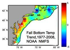


2 MID-ATLANTIC REGIONAL DRIVERS Ocean Circulation Climate Change Northeasters Tropical Storms Critical Habitat Ports Population

3


4 Satellites HF-Radar Gliders Drifters Population Density Buoys Ocean Forecast Ensemble Weather Stations


5 Real-Time Satellite Ground Stations in the Northeast U.S. Since 1992 Satellites: NPP, Terra, Aqua, NOAA Polar Orbiters, Metop & GOES U. Maine City College of N.Y. Rutgers Johns Hopkins U. Delaware


6 High Frequency Radar Since 1996 Corporate Partner: CODAR Ocean Sensors Nested Grids of Hourly Surface Current Maps ^ Combined CODAR & Satellite Products >


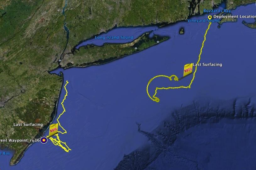
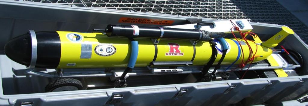
7 Satellite Ocean Color Autonomous Underwater Gliders Since 1998 Satellite SST Corporate Partner: Teledyne Webb Research Subsurface Glider Data


8 Gliderpalooza 2013: So much more than gliders 1. Provide a unique data set to modelers 2. Provide standardized dataset a over ecological scales and information on fish/mammal migrations 3. Provide a 3-D snapshot of the MAB cold pool 4. Provide an extensive distributed network through the peak period of fall storms, demonstrating "surge" capacity 5. Demonstration of a national glider network 6. Proof of data flow through IOOS to NDBC via DMAC 7. Engage undergraduates in ocean observing efforts.

9 CBIBS: MARACOOS partners with NOAA to enhance utility of CBIBS MARACOOS partners will Integrate CBIBS data into MARACOOS data management system, including IOOS DMAC standards and services and QARTOD QA/QC procedures. Integrate CBIBS data feeds into NOAA PORTS system. Support CBIBS planning, operations, and maintenance activities. Expand CBIBS system Support Research and Development applications (e.g., Nutrient Monitoring, Ocean Acidification)

 STPS")

")
10 The Mid-Atlantic Regional Coastal Ocean Modeling System Established ) STPS U. Connecticut 2) NYHOPS Stevens Institute of Technology 3) ROMS Rutgers University 4) HOPS U. Massachusetts, Dartmouth


 Nested")

")
11 Composite Data & Forecast Products + = Remote Sensing Gliders 3-D Nowcasts Hudson River LaTTE MVCO/CBLAST 3-D Nowcasts + = Delaware SW06 ESPreSSO / MARCOOS MAB-GoM (Hatteras to Halifax) Nested Models NENA Cuba to Grand Banks (nested within HyCOM or Mercator) Nested Ocean Models 4-D Forecasts

12 MARACOOS Asset Map Regional Data Federal Data In-Situ Gliders Satellite Radar Models IOOS Standards


")


13 MARACOOS Operations Center University - Coastal Ocean Observation Lab) Satellite Data Acquisition Stations CODAR Network Glider Fleet 3-D Forecasts
 Water Quality a) Floatables, b) Hypoxia, c) Nutrients 3)")


 Coastal")

14 REGIONAL THEMES & SUCCESS STORIES 1) Maritime Operations Safety at Sea 2) Water Quality a) Floatables, b) Hypoxia, c) Nutrients 3) Ecosystem Decision Support - Fisheries 5) Energy Offshore Wind Areas under Consideration for Wind Energy Areas 76 0'W 75 30'W 75 0'W 74 30'W 74 0'W 73 30'W Pennsylvania Wilmington 39 30'N Atlantic City Dover 39 0'N 39 0'N DELAWARE BAY 38 30'N 38 30'N Delaware Ocean City 37 30'N 37 30'N CHESAPEAKE BAY Vi rg i ni a 38 0'N 38 0'N Maryland New Jersey Delaware 37 0'N Maryland 37 0'N 4) Coastal Inundation - Flooding 39 30'N New Jersey Virginia Virginia Beach Nautical Miles Virginia 76 0'W 75 30'W 75 0'W 74 30'W 74 0'W 73 30'W


15 Maritime Safety: U.S. Coast Guard Search and Rescue example Mid-Atlantic Operational Data Flow to SAROPS SAROPS User Interface SAROPS 96-Hour Search Area: SAROPS 96-Hour Search Area: HF Radar 12,000 km 2


16 Water Quality Data and Modeling to respond to 120+ million gallons of sewage released into the Hudson River following North River Wastewater Treatment Plant fire in NYC, July 2011


17 Ecological Decision Support Fisheries + Our Approach: Develop statistical models using bottom trawl surveys and MARACOOS 3-D data to predict species distribution based on observed or forecasted MARACOOS 3-D fields. Downwelling Like Upwelling Upwelling Hate Downwelling Downwelling Upwelling


 Emerging GIS and")

18 Coastal Inundation Chesapeake Inundation Prediction System (CIPS) Partners From Forecast MATURING TECHNOLOGY Regional scale atmospheric wind forecast model Very high-resolution hydrodynamic models with land flooding Very high-resolution land elevation data (LIDAR) Emerging GIS and visualization capabilities for integrated, high-resolution pictures and products To Impact

19 Sandy Surge Prediction based on Rutgers WRF model


20


21 Hurricane Irene August 26, 2011 Damage: >$15 Billion Track Accurate; Intensity Over-predicted Superstorm Sandy October 29, 2012 Damage: >$60 Billion Track Accurate; Intensity Under-predicted


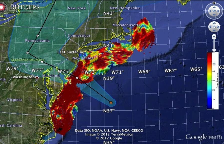


22 Superstorm Sandy Hurricane Irene RU16 Deployed for EPA. Map bottom dissolved oxygen. Provided data on mixing during storm.

23 Reduced Impacts from Sandy Navy: 80 ships sortied, saving $500M Shipping: Christmas 2012 was saved Hoboken: IOOS high resolution surge forecasts saved lives & property Oil and Gas: relied exclusively on US IOOS products and services


24 Spatial validation of Atmospheric Model with 13 MHz Multi-static HF Radar Array Offshore Wind Energy High Resolution Atmospheric Forecast validated with HF radar High Resolution Wind Resource 670 m horizontal resolution Additional Radar Sites 2-Site Mono-static Coverage Bi-static Geometries 2-Site Multi-static Coverage
25 A Few Lessons Learned Not operational in the same sense as NWS MARACOOS = Real-time with operational aspirations Hardening not yet where it needs to be MARACOOS supports the operational system

26 Are we able to successfully execute R2O? 1. Research Operations/Application 2. Research? Operations/Application 3. Research Operations/Application


27 Product Development Infrastructure User/Stakeholder Infrastructure User Council Product Groups Stakeholder Liaison Service User Council (Geographic and Theme-focused, and leveraged through partnerships) Enhanced Cross-Regional focus Regionally and through IOOS Association EDS: Fish Wind Energy Marine Safety Water Quality Inundation


28 MyMARACOOS Fishing Web Site Mobile Site Extensive outreach activities Leveraging various data, models and expertise from private, public and academic sectors mymaracoos.org Customized to meet user needs IOOS Standards


29 DATA & PRODUCTS Regional Priority Themes Weather Mesonet Regional Observation & Modeling Capabilities HF Radar Network Statistical STPS Satellite Imagery Glider Surveys Dynamical Ocean Forecasts Theme 1. Maritime Safety Operational Input to USCG SAROPS Operational input to USCG SAROPS Operational input to USCG SAROPS SST for survivability planning Assimilation dataset for forecast models Surface currents for SAROPS Theme 2. Ecological Decision Support Weather forecast ensemble validation Circulation and divergence maps for habitat SST & Color for habitat Subsurface T & S for habitat 3-D fields of T, S, circulation for habitat Theme 3. Water Quality Winds for transport, river plumes, & upwelling Surface currents for flotables, bacteria, spill response Surface currents for flotables, bacteria, spill response Ocean color for river plumes Nearshore dissolved oxygen surveys Surface currents for floatables, bacteria, spill response Theme 4. Coastal Inundation Weather forecast ensemble validation Current forecast model validation SSTs assimilation into forecast models Assimilation dataset for forecast models Nested forecast ensembles Theme 5. Offshore Energy Historical analysis & wind model validation Historical current analysis & wind model validation Historical analysis surface fronts & plumes for siting Historical analysis of subsurface fronts & plumes Coupled oceanatmosphere models for resource estimates


30 Crowdsourced Bathymetry MARACOOS partners Leverage existing infrastructure Low-cost bathmetry Entrepreneurship of MARACOOS partners Not MARACOOS funded; but now promoted
31 Some successes, but Big challenges lie ahead: 1. Growing needs of the stakeholders 2. Expectation to continue to build out the system (10-year BOP) 3. Fiscal future? (in & out of government) 4. Pressure to demonstrate value
32 However Clear added value for society through MARACOOS: Stakeholder user relationships and interactions Serving as the gold standard for data One-stop-shop for high quality regional data & stds. Venue for drawing in and promoting product developers and collaboration Neutrality Flexibility and greater freedoms Great return on investment

33 In the present funding environment, it is IMPOSSIBLE to evolve and function alone. A key way of moving forward is with collaborative and practical PARTNERSHIPS.


34 THANK YOU
A Brief Introduction to MARACOOS: Presentation to the Chesapeake Bay Program BASIN Initiative
 A Brief Introduction to MARACOOS: Presentation to the Chesapeake Bay Program BASIN Initiative January 10, 2014 Gerhard F. Kuska, Ph.D. Executive Director 5 Questions/Areas for Today: 1. Objectives of the
MACOORA Theme/MARCOOS Capabilities Product Matrix
 Validation Validation Adaptive Sampling 1 A) BACKGROUND MACOORA Theme/MARCOOS Capabilities Product Matrix B) GOALS AND OBJECTIVES MARACOOS = MACOORA + MARCOOS + Enhancements 1. Regional Management Regional
The U.S. Certified Mid Atlantic Regional Metocean Network as a Testbed for GOOS
 The U.S. Certified Mid Atlantic Regional Metocean Network as a Testbed for GOOS Scott Glenn, Josh Kohut, Hugh Roarty, Travis Miles, Joe Brodie, Greg Seroka Oscar Schofield, Grace Saba, Mike Crowley Rutgers
NOAA Surface Weather Program
 NOAA Surface Weather Program Maintenance Decision Support System Stakeholder Meeting #9 Jim O Sullivan NOAA Surface Weather Program Manager NWS Office of Climate, Water, and Weather Services September
Prepared for MACOORA by the MARCOOS PIs
 HF Radar Gap Analysis for the Mid-Atlantic Bight: Serving regional and sub-regional themes of Maritime Safety, Ecological Decision Making, Coastal Inundation and Water Quality. Prepared for MACOORA by
The Delaware Environmental Monitoring & Analysis Center
 The Delaware Environmental Monitoring & Analysis Center Tina Callahan Delaware Estuary Science & Environmental Summit 2013 January 27-30, 2013 What is DEMAC? Delaware Environmental Monitoring & Analysis
West Florida Shelf and Tampa Bay Responses to Hurricane Irma: What Happened and Why
 West Florida Shelf and Tampa Bay Responses to Hurricane Irma: What Happened and Why R.H. Weisberg Y. Liu J. Chen College of Marine Science University of South Florida St. Petersburg, FL SECOORA Webinar
Ocean Observatories Initiative. Oscar Schofield Rutgers University. Ocean Leadership October 2010
 Ocean Observatories Initiative Oscar Schofield Rutgers University Ocean Leadership October 2010 What is OOI? THE VISION To launch an era of scientific discovery across and within the ocean basins, utilizing
Operational Estuarine & Coastal Forecast Systems in NOAA s. National Ocean Service
 Operational Estuarine & Coastal Forecast Systems in NOAA s. National Ocean Service Eugene Wei, Frank Aikman III and Richard Patchen NOAA S S National Ocean Service Workshop on: Data Assimilation in Support
HFR Surface Currents Observing System in Lower Chesapeake Bay and Virginia Coast
 HFR Surface Currents Observing System in Lower Chesapeake Bay and Virginia Coast Larry P. Atkinson, Teresa Garner, and Jose Blanco Center for Coastal Physical Oceanography Old Dominion University Norfolk,
Molly McCammon Alaska Ocean Observing System October 15, 2012
 Molly McCammon Alaska Ocean Observing System October 15, 2012 Marine Operations Safe a& efficient shipping & recreational boating, search & rescue, spill response & offshore energy development Weather
12/2/15. Providing observa.ons, data and informa.on products to meet agency and stakeholder needs
 12/2/15 Providing observa.ons, data and informa.on products to meet agency and stakeholder needs 1 Part of the Integrated Ocean Observing System (IOOS) Governed through a Memorandum of Agreement Fiscal
Observing System Requirements for the Harmful Algal Bloom Forecast System in the Gulf of Mexico
 Observing System Requirements for the Harmful Algal Bloom Forecast System in the Gulf of Mexico July 2007 Background The Harmful Algal Bloom (HAB) Forecast System provides nowcasts and forecasts of Karenia
Environmental Data In Support of Search & Rescue Operations in the Central Mediterranean Sea
 Environmental Data In Support of Search & Rescue Operations in the Central Mediterranean Sea Dr. Eric Comerma (RPS ASA) eric.comerma@rpsgroup.com Cathleen Turner (RPS ASA) Prof. Aldo Drago (Univ. of Malta)
ALASKA OCEAN OBSERVING SYSTEM 2016 ANNUAL IMPACT REPORT
 ALASKA OCEAN OBSERVING SYSTEM 2016 ANNUAL IMPACT REPORT 1 ALASKA OCEAN OBSERVING SYSTEM 2016 ANNUAL IMPACT REPORT 2 ALASKA OCEAN OBSERVING SYSTEM 2016 ANNUAL IMPACT REPORT Letter from Executive Director
Critical Issues in Assessment of Offshore Wind Farm Development on Dispersion and Settling of Scallop Larvae in the Northeast U.S.
 Critical Issues in Assessment of Offshore Wind Farm Development on Dispersion and Settling of Scallop Larvae in the Northeast U.S. Coastal Ocean Changsheng Chen School for Marine Science and Technology
OCEANOGRAPHIC DATA MANAGEMENT
 OCEANOGRAPHIC DATA MANAGEMENT Presented to: Environmental Disaster Data Management Meeting Russ Beard Director, National Coastal Data Development Center Interim Science Coordinator, Gulf Restoration Council
Improving Sub-Seasonal to Seasonal Prediction at NOAA
 Improving Sub-Seasonal to Seasonal Prediction at NOAA Dr. Louis W. Uccellini Director, National Weather Service NOAA Assistant Administrator for Weather Services July 13, 2016 Congressional Briefing Value
Access to IOOS Data Relevant to OOI. Kathleen Bailey NOAA/NOS/IOOS January 6, 2016
 Access to IOOS Data Relevant to OOI Kathleen Bailey NOAA/NOS/IOOS January 6, 2016 The U.S. Integrated Ocean Observing System (IOOS) Federal Regional Satellites 600+: Buoys, Water Level stations, Coastal
North Atlantic Coast Comprehensive Study (NACCS) APPENDIX A: ENGINEERING
 APPENDIX A: ENGINEERING") North Atlantic Coast Comprehensive Study (NACCS) APPENDIX A: ENGINEERING NORTH ATLANTIC COAST COMPREHENSIVE STUDY: RESILIENT ADAPTATION TO INCREASING RISK Appendix A - Engineering Table of Contents North
North Atlantic Coast Comprehensive Study (NACCS) APPENDIX A: ENGINEERING NORTH ATLANTIC COAST COMPREHENSIVE STUDY: RESILIENT ADAPTATION TO INCREASING RISK Appendix A - Engineering Table of Contents North
NORTHEAST COASTAL OCEAN FORECAST SYSTEM (NECOFS)
") NORTHEAST COASTAL OCEAN FORECAST SYSTEM (NECOFS) R. C. Beardsley and C. Chen MITSG 13-27 Sea Grant College Program Massachusetts Institute of Technology Cambridge, Massachusetts 02139 NOAA Grant No. NA10OAR4170086
NORTHEAST COASTAL OCEAN FORECAST SYSTEM (NECOFS) R. C. Beardsley and C. Chen MITSG 13-27 Sea Grant College Program Massachusetts Institute of Technology Cambridge, Massachusetts 02139 NOAA Grant No. NA10OAR4170086
Evolution of NOAA s Observing System Integrated Analysis (NOSIA)
") Evolution of NOAA s Observing System Integrated Analysis (NOSIA) Presented to the 13th Symposium on Societal Applications: Policy, Research and Practice (paper 9.1) Louis Cantrell Jr., and D. Helms, R.
Evolution of NOAA s Observing System Integrated Analysis (NOSIA) Presented to the 13th Symposium on Societal Applications: Policy, Research and Practice (paper 9.1) Louis Cantrell Jr., and D. Helms, R.
Marine Spatial Planning: A Tool for Implementing Ecosystem-Based Management
 Marine Spatial Planning: A Tool for Implementing Ecosystem-Based Management Steven Murawski, Ph.D., Ecosystem Goal Team Lead National Oceanic and Atmospheric Administration NOAA November 16, 2009 1 To
Weather Information for Surface Transportation (WIST): Update on Weather Impacts and WIST Progress
: Update on Weather Impacts and WIST Progress") Weather Information for Surface Transportation (WIST): Update on Weather Impacts and WIST Progress Samuel P. Williamson Office of the Federal Coordinator for Meteorological Services and Supporting Research
Weather Information for Surface Transportation (WIST): Update on Weather Impacts and WIST Progress Samuel P. Williamson Office of the Federal Coordinator for Meteorological Services and Supporting Research
Arctic. Ocean Observing Build Out Plan. alaska ocean observing system. March 1, 2013 draft. Tom Van Pelt
 Arctic Ocean Observing Build Out Plan March 1, 2013 draft Tom Van Pelt alaska ocean observing system Tom Van Pelt Why a coastal observing system in the Arctic? The Arctic is booming with increased activity
Yi Chao Jet Propulsion Laboratory California Institute of Technology & Joint Institute for Regional Earth System Science and Engineering (JIFRESSE)
") Strategy to Develop a 3D Ocean Circulation Forecasting System for Cook Inlet Yi Chao Jet Propulsion Laboratory California Institute of Technology & Joint Institute for Regional Earth System Science and
Strategy to Develop a 3D Ocean Circulation Forecasting System for Cook Inlet Yi Chao Jet Propulsion Laboratory California Institute of Technology & Joint Institute for Regional Earth System Science and
HF radarcontribution to South Africa Blue Economy
 HF radarcontribution to South Africa Blue Economy Anton G Kjelaas1, Andres Alonso- Martirena2, Chad Whelan3 South Africa- Norway Science Week 2016 Oct 31- Nov 4 2016 1 2 3 BLUE ECONOMY Sustainable use
Coastal Response Research Center. Nancy Kinner University of New Hampshire (UNH) Michele Jacobi NOAA ORR. September 27, 2007
 Michele Jacobi NOAA ORR. September 27, 2007") Coastal Response Research Center Nancy Kinner University of New Hampshire (UNH) Michele Jacobi NOAA ORR September 27, 2007 1 Coastal Response Research Center (CRRC) CRRC is partnership between NOAA s Office
Coastal Response Research Center Nancy Kinner University of New Hampshire (UNH) Michele Jacobi NOAA ORR September 27, 2007 1 Coastal Response Research Center (CRRC) CRRC is partnership between NOAA s Office
Overview of NOS Coastal Ocean Operational Forecast Systems
 Overview of NOS Coastal Ocean Operational Forecast Systems Aijun Zhang NOAA/NOS Center for Operational Oceanographic Products and Services (CO-OPS) Frank Aikman III NOAA/NOS/OCS Coast Survey Development
Hurricane Season 2010 & NOAA s Deepwater Response
 Hurricane Season 2010 & NOAA s Deepwater Response What s Happened? What Will 2010 Bring? Possible Shoreline Effects Darin Figurskey Meteorologist-in-Charge NOAA s NWS Raleigh, NC NOAA s National Weather
Towards a Comprehensive Mid-Atlantic Regional Association Coastal Ocean Observing System (MARACOOS)
") RUTGERS, The State University of New Jersey Towards a Comprehensive Mid-Atlantic Regional Association Coastal Ocean Observing System (MARACOOS) Sponsor: National Ocean Service (NOS), National Oceanic and
RUTGERS, The State University of New Jersey Towards a Comprehensive Mid-Atlantic Regional Association Coastal Ocean Observing System (MARACOOS) Sponsor: National Ocean Service (NOS), National Oceanic and
Impact of Sea Level Rise on Future Storm-induced Coastal Inundation
 Impact of Sea Level Rise on Future Storm-induced Coastal Inundation Changsheng Chen School for Marine Science and Technology, University of Massachusetts-Dartmouth Email: c1chen@umassd.edu 04/14/2015 Outline
Hyperlocal Marine Weather: What s Happening?
 Hyperlocal Marine Weather: What s Happening? André van der Westhuysen 1,2 and Jeff McQueen 1 1 NOAA / National Weather Service National Centers for Environmental Prediction 2 I.M Systems Group, Rockville
Advancing Real Time Observations and Coastal Modeling Forecasts-
 Advancing Real Time Observations and Coastal Modeling Forecasts- Moving Forward in a Changing Coastal Landscape Next Generation Navigation-Coastal Operations- Coastal and Nearshore Coastal Operational
Phased Deployment and Operation of the Mid-Atlantic Regional Coastal Ocean Observing System (MARCOOS)
") Phased Deployment and Operation of the Mid-Atlantic Regional Coastal Ocean Observing System (MARCOOS) Recipient Institution: Rutgers, The State University of New Jersey Principal Investigator: Scott Glenn,
Phased Deployment and Operation of the Mid-Atlantic Regional Coastal Ocean Observing System (MARCOOS) Recipient Institution: Rutgers, The State University of New Jersey Principal Investigator: Scott Glenn,
MERSEA Marine Environment and Security for the European Area
 MERSEA Marine Environment and Security for the European Area Development of a European system for operational monitoring and forecasting of the ocean physics, biogeochemistry, and ecosystems, on global
Observation system for early warning of HAB events
 Observation system for early warning of HAB events Vera L. Trainer, NOAA Fisheries Northwest Fisheries Science Center Marine Biotoxins Program Seattle, Washington, USA Juan de Fuca eddy Regional HAB OOS
Earth Observation in coastal zone MetOcean design criteria
 ESA Oil & Gas Workshop 2010 Earth Observation in coastal zone MetOcean design criteria Cees de Valk BMT ARGOSS Wind, wave and current design criteria geophysical process uncertainty modelling assumptions
New NASA Ocean Observations and Coastal Applications
 New NASA Ocean Observations and Coastal Applications Duane Armstrong Chief, Applied Science & Technology Project Office August 20, 2014 1 Outline NASA s new Earth Science Ocean Science Missions for 2014
SAWS: Met-Ocean Data & Infrastructure in Support of Industry, Research & Public Good. South Africa-Norway Science Week, 2016
 SAWS: Met-Ocean Data & Infrastructure in Support of Industry, Research & Public Good South Africa-Norway Science Week, 2016 Marc de Vos, November 2016 South Africa: Context http://learn.mindset.co.za/sites/default/files/resourcelib/e
Urgent Computing for Hurricane Forecasts
 Urgent Computing for Hurricane Forecasts Gabrielle Allen Center for Computation & Technology Dept Computer Science Louisiana State University gallen@cct.lsu.edu Representing the SURA Coastal Ocean Observing
Comparison of NYHOPS hydrodynamic model SST predictions with satellite observations in the Hudson River tidal, estuarine, and coastal plume region
 Comparison of NYHOPS hydrodynamic model SST predictions with satellite observations in the Hudson River tidal, estuarine, and coastal plume region Abstract Shashi Bhushan 1, Alan F. Blumberg 2, Nickitas
Liana Talaue McManus. Division of Marine Affairs and Policy Rosenstiel School of Marine & Atmospheric Science University of Miami
 Liana Talaue McManus Division of Marine Affairs and Policy Rosenstiel School of Marine & Atmospheric Science University of Miami Outline 1. Coasts as vulnerable & resilient social ecological systems 2.
Toward Environmental Predictions MFSTEP. Executive summary
 Research Project co-funded by the European Commission Research Directorate-General 5 th Framework Programme Energy, Environment and Sustainable Development Contract No. EVK3-CT-2002-00075 Project home
Mersea Oil Spill Drift Forecast Demonstrations in TOP2
 Mersea Oil Spill Drift Forecast Demonstrations in TOP2 Bruce Hackett (met.no), George Zodiatis (UCY), Pierre Daniel (MeteoFrance), Francois Parthiot (Cedre) Presented at 3rd Mersea Plenary Meeting, CNR,
The Coastal Field Data Collection Program (CFDC) Waves & Coastal Observations for the Corps and the Nation
 Waves & Coastal Observations for the Corps and the Nation") The Coastal Field Data Collection Program (CFDC) Waves & Coastal Observations for the Corps and the Nation Bill Birkemeier Program Manager William.Birkemeier@usace.army.mil 10 August 2010 US Army Corps
The Coastal Field Data Collection Program (CFDC) Waves & Coastal Observations for the Corps and the Nation Bill Birkemeier Program Manager William.Birkemeier@usace.army.mil 10 August 2010 US Army Corps
USGS National Geospatial Program Understanding User Needs. Dick Vraga National Map Liaison for Federal Agencies July 2015
 + USGS National Geospatial Program Understanding User Needs Dick Vraga National Map Liaison for Federal Agencies July 2015 + Topics 2 Background Communities of Use User Surveys National Map Liaisons Partnerships
NOAA Hurricane Forecast Improvement Project
 NOAA Hurricane Forecast Improvement Project Fred Toepfer Hurricane Forecast Improvement Project Manager November 9 th, 2009 Outline NOAA Hurricane Forecast Improvement Project Driving Issue Purpose NOAA
Add NOAA nowcoast Layers to Maps
 WebEOC Maps Add-on Quick Reference Guide Add NOAA nowcoast Layers to Maps Overview With Maps Add-on, you can configure an unlimited number of map layers. These layers allow you to control the data you
Alaska Ocean Observing System 101 Anchorage, Alaska
 Alaska Ocean Observing System 101 Anchorage, Alaska Molly McCammon, Director Alaska Ocean Observing System (AOOS) A Regional Observing System within the Integrated Ocean Observing System www.aoos.org IOOS
The Field Research Facility, Duck, NC Warming Ocean Observations and Forecast of Effects
 The Field Research Facility, Duck, NC Warming Ocean Observations and Forecast of Effects A potential consequence of a warming ocean is more frequent and more intense wind events (Hurricanes & Typhoons)
ICAN Great Lakes 2010 Workshop
 ICAN Great Lakes 2010 Workshop Chris Cortina Maryland s Chesapeake & Coastal Program MD Department of Natural Resources Maryland s Coastal Atlas: What is it? The Coastal Atlas is an online mapping and
An Integrated Network of In situ and Remote Sensors to Characterize the Somali Current
 DISTRIBUTION STATEMENT A. Approved for public release; distribution is unlimited. An Integrated Network of In situ and Remote Sensors to Characterize the Somali Current Eric J. Terrill, Ph.D. Director,
New Jersey Department of Transportation Extreme Weather Asset Management Pilot Study
 New Jersey Department of Transportation Extreme Weather Asset Management Pilot Study Overview Prepared for: June 26, 2018 Introduction Overview of Pilot Study New Jersey s Climate New Jersey s Transportation
Understanding Weather and Climate Risk. Matthew Perry Sharing an Uncertain World Conference The Geological Society, 13 July 2017
 Understanding Weather and Climate Risk Matthew Perry Sharing an Uncertain World Conference The Geological Society, 13 July 2017 What is risk in a weather and climate context? Hazard: something with the
Conrad Blucher Institute for Surveying and Science
 d James Rizzo Assistant irector of Operations - Office: 361-825-5758 Mobile: 361-549-5120 james.rizzo@tamucc.edu d d Texas Coastal Ocean Observation N Network (TCOON) Began in 1988 with 2 stations in Bay
The known requirements for Arctic climate services
 The known requirements for Arctic climate services based on findings described in STT White paper 8/2015 Johanna Ekman / EC PHORS STT Regional drivers The Arctic region is home to almost four million people
Novel Acoustic Techniques for Assessing Fish Schooling in the Context of an Operational Ocean Observatory
 Novel Acoustic Techniques for Assessing Fish Schooling in the Context of an Operational Ocean Observatory Christopher Jones Applied Physics Laboratory, University of Washington 1013 NE 40 th Street Seattle,
University of New Hampshire Scholars' Repository
 University of New Hampshire University of New Hampshire Scholars' Repository Center for Coastal and Ocean Mapping Center for Coastal and Ocean Mapping 3-2009 Environmental Response Management Application
COASTAL DATA APPLICATION
 2015 Coastal GeoTools Proactive By Design. Our Company Commitment COASTAL DATA APPLICATION Projecting Future Coastal Flood Risk for Massachusetts Bay Bin Wang, Tianyi Liu, Daniel Stapleton & Michael Mobile
CLIMATE CHANGE ADAPTATION BY MEANS OF PUBLIC PRIVATE PARTNERSHIP TO ESTABLISH EARLY WARNING SYSTEM
 CLIMATE CHANGE ADAPTATION BY MEANS OF PUBLIC PRIVATE PARTNERSHIP TO ESTABLISH EARLY WARNING SYSTEM By: Dr Mamadou Lamine BAH, National Director Direction Nationale de la Meteorologie (DNM), Guinea President,
NORTH ATLANTIC COAST COMPREHENSIVE STUDY (NACCS) STORM MODELING AND STATISTICAL ANALYSIS FOR
 STORM MODELING AND STATISTICAL ANALYSIS FOR") NORTH ATLANTIC COAST COMPREHENSIVE STUDY (NACCS) STORM MODELING AND STATISTICAL ANALYSIS FOR 237 237 217 217 200 200 80 27 252 174.59 COMPUTING 255 0 163 COASTAL 131 239 110 HAZARDS 112 62 255 255 0 0
NORTH ATLANTIC COAST COMPREHENSIVE STUDY (NACCS) STORM MODELING AND STATISTICAL ANALYSIS FOR 237 237 217 217 200 200 80 27 252 174.59 COMPUTING 255 0 163 COASTAL 131 239 110 HAZARDS 112 62 255 255 0 0
Monitoring the coastal ocean: from local to regional
 Monitoring the coastal ocean: from local to regional Luísa Bastos University of Porto / CIIMAR RAIA partners Ocean monitoring To answer key societal and scientific challenges navigation safety, fisheries,
From Vulnerability to Resilience And the Tools to Get There. Out of Harm s Way Partnership for the Delaware Estuary August 1, 2012
 From Vulnerability to Resilience And the Tools to Get There Out of Harm s Way Partnership for the Delaware Estuary August 1, 2012 Today s Presentation Tour of New Jersey Challenges Definitions so we re
Darren Wright Maritime Services Program Manager Center for Operational Oceanographic Products and Services (CO-OPS)
") Darren Wright Maritime Services Program Manager Center for Operational Oceanographic Products and Services (CO-OPS) Center for Operational Oceanographic Products and Services (CO-OPS) National Water Level
Darren Wright Maritime Services Program Manager Center for Operational Oceanographic Products and Services (CO-OPS) Center for Operational Oceanographic Products and Services (CO-OPS) National Water Level
Northeast U.S. Early Season Preview 2017 FISHING ACTION STARTING TO WARM UP ALREADY WITH LOTS OF FISH EXPECTED IN MAY
 Northeast U.S. Early Season Preview 2017 FISHING ACTION STARTING TO WARM UP ALREADY WITH LOTS OF FISH EXPECTED IN MAY By Matthew A. Upton and Mitchell A. Roffer ROFFS concludes its 2017 spring preview
USING MIKE TO MODEL COASTAL CATASTROPHE RISK
 USING MIKE TO MODEL COASTAL CATASTROPHE RISK Nicola Howe, Christopher Thomas, Joss Matthewman, John Maskell* 1 SUMMARY About RMS Who are we and what do we do? How do we use MIKE in our workflow? Case study:
Ruoying He. Ocean Observating and Modeling Group (OOMG) North Carolina State University
 North Carolina State University") A Coupled Marine Environmental Assessment and Prediction System for the Southeastern U.S. Coastal Ocean in Support of Effective Marine Ecosystem-Based Management, Efficient Marine Operations, and Resilient
A Coupled Marine Environmental Assessment and Prediction System for the Southeastern U.S. Coastal Ocean in Support of Effective Marine Ecosystem-Based Management, Efficient Marine Operations, and Resilient
NWS Operational Marine and Ocean Forecasting. Overview. Ming Ji. Ocean Prediction Center National Weather Service/NCEP. CIOSS/CoRP
 NWS Operational Marine and Ocean Forecasting Overview Ming Ji Ocean Prediction Center National Weather Service/NCEP CIOSS/CoRP CoRP Symposium Corvallis, OR Aug. 12-13, 13, 2008 Titanic Telegram Marine
Toward a Revised RCOOS Plan for SECOORA
 Toward a Revised RCOOS Plan for SECOORA Robert Weisberg College of Marine Science University of South Florida St. Petersburg, FL SECOORA Annual Workshop May 2017 Ad hoc Committee Axiom Gap Filling Tool
Current and Upcoming NASA Hurricane Measurement Missions National Hurricane Conference
 NASA Science Mission Directorate Earth Science Division Applied Sciences Program Current and Upcoming NASA Hurricane Measurement Missions National Hurricane Conference April 18, 2017 Formulation Implementation
United States Multi-Hazard Early Warning System
 United States Multi-Hazard Early Warning System Saving Lives Through Partnership Lynn Maximuk National Weather Service Director, Central Region Kansas City, Missouri America s s Weather Enterprise: Protecting
HY-2A Satellite User s Guide
 National Satellite Ocean Application Service 2013-5-16 Document Change Record Revision Date Changed Pages/Paragraphs Edit Description i Contents 1 Introduction to HY-2 Satellite... 1 2 HY-2 satellite data
NOAA s Capabilities in Wind Energy
 NCAR-Xcel-NOAA Meeting May 11-12, 2010 Boulder, CO NOAA s Capabilities in Wind Energy Melinda Marquis, Ph.D. NOAA Earth System Research Laboratory Outline NOAA has a potential role in improving wind forecasting
The National Weather Service of the Future: Building a Weather-Ready Nation
 The of the Future: Building a Weather-Ready Nation Dr. Louis W. Uccellini Director, NOAA Assistant Administrator for Weather Services NCEP Production Suite Review December 2, 2014 Outline Building a Weather-Ready
An Overview of Operations at the West Gulf River Forecast Center Gregory Waller Service Coordination Hydrologist NWS - West Gulf River Forecast Center
 National Weather Service West Gulf River Forecast Center An Overview of Operations at the West Gulf River Forecast Center Gregory Waller Service Coordination Hydrologist NWS - West Gulf River Forecast
PROJECT DESCRIPTION. 1. Introduction Problem Statement
 Salmun, H: A proposal submitted to PSC-CUNY program on October 15, 2009. Statistical prediction of storm surge associated with East Coast Cool-weather Storms at The Battery, New York. Principal Investigator:
Forecast of Nearshore Wave Parameters Using MIKE-21 Spectral Wave Model
 Forecast of Nearshore Wave Parameters Using MIKE-21 Spectral Wave Model Felix Jose 1 and Gregory W. Stone 2 1 Coastal Studies Institute, Louisiana State University, Baton Rouge, LA 70803 2 Coastal Studies
Environmental Response Management Application
 Environmental Response Management Application Coastal Response Research Center Nancy Kinner, Michele Jacobi, Rob Braswell, Kurt Schwehr & Amy Merten RRT III May 14, 2008 1 Talk Outline Overview of Center
Summary Visualizations for Coastal Spatial Temporal Dynamics
 Summary Visualizations for Coastal Spatial Temporal Dynamics October 24 2011 Providence, RI Sidharth Thakur 1, Laura Tateosian 2, Helena Mitasova, Eric Hardin, and Margery Overton 1. sthakur@renci.org,
July 24, 2017 Annapolis, MD Bryan A. Jackson NWS Sterling, VA Marine Program Leader
 When Wicked Weather Strikes Insights into Chesapeake Bay Weather July 24, 2017 Annapolis, MD Bryan A. Jackson NWS Sterling, VA Marine Program Leader Mission of the National Weather Service Provide climate,
Use of Satellite Earth Observations, in situ data and numerical model capabilities for oil spill contingency. Page 1
 Use of Satellite Earth Observations, in situ data and numerical model capabilities for oil spill contingency Page 1 Oil spill service Page 2 Interest of Earth-Observation (EO) data for oil and gas companies
Great Lakes Information Network GIS (Queryable by topic, geography, organization, and upload date 73 layers as of October, 2009)
") Google Earth Files for the Great Lakes and Beyond GLOS Mapping Workshop Alpena, Michigan November 9, 2009 David Hart GIS Specialist University of Wisconsin Sea Grant Institute GREAT LAKES Great Lakes Information
Google Earth Files for the Great Lakes and Beyond GLOS Mapping Workshop Alpena, Michigan November 9, 2009 David Hart GIS Specialist University of Wisconsin Sea Grant Institute GREAT LAKES Great Lakes Information
South Bay Coastal Ocean Observing System California Clean Beaches Initiative
 South Bay Coastal Ocean Observing System California Clean Beaches Initiative Third Quarterly Report April, 2003 to City of Imperial Beach Eric Terrill 1 1 Scripps Institution of Oceanography, University
NOAA Observing System Integrated Analysis (NOSIA) Applications
 Applications") NOAA Observing System Integrated Analysis (NOSIA) Applications Aaron Pratt 1,2, PhD, David Helms 2, Louis Cantrell 2,4, PhD, Vincent Ries 4 1 Science and Technology Corporation 2 NOAA/NESDIS/OSD/TPIO 3
NOAA Observing System Integrated Analysis (NOSIA) Applications Aaron Pratt 1,2, PhD, David Helms 2, Louis Cantrell 2,4, PhD, Vincent Ries 4 1 Science and Technology Corporation 2 NOAA/NESDIS/OSD/TPIO 3
John Callahan (Delaware Geological Survey) Kevin Brinson, Daniel Leathers, Linden Wolf (Delaware Environmental Observing System)
 Kevin Brinson, Daniel Leathers, Linden Wolf (Delaware Environmental Observing System)") John Callahan (Delaware Geological Survey) Kevin Brinson, Daniel Leathers, Linden Wolf (Delaware Environmental Observing System) Delaware is extremely vulnerable to the impacts of coastal flooding Tropical
John Callahan (Delaware Geological Survey) Kevin Brinson, Daniel Leathers, Linden Wolf (Delaware Environmental Observing System) Delaware is extremely vulnerable to the impacts of coastal flooding Tropical
Casco Bay Estuary Partnership (CBEP) USM Muskie School 34 Bedford St 228B. Portland, ME
 USM Muskie School 34 Bedford St 228B. Portland, ME") Casco Bay Estuary Partnership (CBEP) USM Muskie School 34 Bedford St 228B Wishcamper Center Portland, ME 04104 9300 Malcolm L. Spaulding Applied Science Associates 55 Village Square Drive South Kingstown,
Casco Bay Estuary Partnership (CBEP) USM Muskie School 34 Bedford St 228B Wishcamper Center Portland, ME 04104 9300 Malcolm L. Spaulding Applied Science Associates 55 Village Square Drive South Kingstown,
Introduction of Korea Operational Oceanographic System (KOOS)
") PICES-2010, Portland, USA October 21-31, 2010 Introduction of Korea Operational Oceanographic System (KOOS) Oct. 28, 2010 Kwang-Soon Park, Dong-Young Lee, Ki-Cheon Jun, Sang-Ik Kim, Jae-Il Kwon and Jung-Woon
PICES-2010, Portland, USA October 21-31, 2010 Introduction of Korea Operational Oceanographic System (KOOS) Oct. 28, 2010 Kwang-Soon Park, Dong-Young Lee, Ki-Cheon Jun, Sang-Ik Kim, Jae-Il Kwon and Jung-Woon
4DVAR Data Assimilation with Chesapeake Bay Operational Forecasting System
 4DVAR Data Assimilation with Chesapeake Bay Operational Forecasting System Bin Zhang 1, Matt Hoffman 2, Lyon Lanerolle 3, Chris Brown 1,4 1 Cooperative Institute of Climate & Satellites/Earth System Science
Introduction: The Gulf of Mexico Alliance. The Gulf GAME project MERMAid and PHINS Results & Conclusions What s next? Examples
 AAG Las Vegas March 25, 2009 Introduction: Ocean governance and Ecosystem-Based Management The Gulf of Mexico Alliance Habitat Identification and Characterization The Gulf GAME project MERMAid and PHINS
Expansion of NCEP Operational Hurricane Weather Research and Forecast (HWRF) Model Forecast Guidance to all Global Tropical Cyclones
 Model Forecast Guidance to all Global Tropical Cyclones") Expansion of NCEP Operational Hurricane Weather Research and Forecast (HWRF) Model Forecast Guidance to all Global Tropical Cyclones Dr. Vijay Tallapragada, Hurricane Team Leader & HFIP Development Manager,
Expansion of NCEP Operational Hurricane Weather Research and Forecast (HWRF) Model Forecast Guidance to all Global Tropical Cyclones Dr. Vijay Tallapragada, Hurricane Team Leader & HFIP Development Manager,
A Community Terrain-Following Ocean Modeling System (ROMS)
") DISTRIBUTION STATEMENT A. Approved for public release; distribution is unlimited. A Community Terrain-Following Ocean Modeling System (ROMS) PI: Hernan G. Arango Department of Marine and Coastal Sciences,
DISTRIBUTION STATEMENT A. Approved for public release; distribution is unlimited. A Community Terrain-Following Ocean Modeling System (ROMS) PI: Hernan G. Arango Department of Marine and Coastal Sciences,
Southern Florida to Cape Hatteras Spring Season Preview 2018 UPDATE ON U.S. EAST COAST GULF STREAM CONDITIONS
 Southern Florida to Cape Hatteras Spring Season Preview 2018 UPDATE ON U.S. EAST COAST GULF STREAM CONDITIONS By ROFFS Gregory J. Gawlikowski ROFFS continues its spring preview series by providing an overall
CASA WX DFW URBAN DEMONSTRATION NETWORK
 CASA WX DFW URBAN DEMONSTRATION NETWORK Goals Background on Regional CASA WX Project Explain the capabilities, structure of the Radar Network Present the CASA WX DFW Test Bed will be rolled out Describe
The Stevens Integrated Maritime Surveillance and Forecast System: Expansion and Enhancement
 The Stevens Integrated Maritime Surveillance and Forecast System: Expansion and Enhancement Michael S. Bruno and Alan F. Blumberg Center for Maritime Systems Stevens Institute of Technology Castle Point
STAMP Spa)al Tools for Arc)c Mapping & Planning. Creating an interactive data tool to improve access and usability of Arctic data
al Tools for Arc)c Mapping & Planning. Creating an interactive data tool to improve access and usability of Arctic data") STAMP Spa)al Tools for Arc)c Mapping & Planning Creating an interactive data tool to improve access and usability of Arctic data Mission Provide easy access to physical, chemical, and biological data Network
STAMP Spa)al Tools for Arc)c Mapping & Planning Creating an interactive data tool to improve access and usability of Arctic data Mission Provide easy access to physical, chemical, and biological data Network
Response Case Study: April 2014 Historic Flood Event. Severe Weather April 29 30, 2014
 Response Case Study: April 2014 Historic Flood Event NOAA s Regional Preparedness Training (NRPT) Natural Disaster Causing Technology Disasters in Mobile Bay Area Kimberly Albins Gulf of Mexico Regional
Altimetry for Coastal Applications. Paul M. DiGiacomo and Amanda Bittinger NOAA CoastWatchatch Program 5 February 2008
 Altimetry for Coastal Applications Paul M. DiGiacomo and Amanda Bittinger NOAA CoastWatchatch Program 5 February 2008 IGOS COASTAL THEME REPORT Published January 2006, IOC http://www.igospartners.org/d
Storm Surge/Coastal Inundation State of the Union. Jamie Rhome Storm Surge Team Lead NOAA/National Hurricane Center
 Storm Surge/Coastal Inundation State of the Union Jamie Rhome Storm Surge Team Lead NOAA/National Hurricane Center 2 Tampa: Cat 5 Scenario 3 4 The Stakes are High Combination of SLR and increasing coastal
Direct Readout at the Meteorological Service of Canada
 Direct Readout at the Meteorological Service of Canada CSPP Users Meeting 2015 Darmstadt, Germany April 14-16, 2015 David Bradley Manager, Earth Observation and Geomatics Meteorological Service of Canada