Access to IOOS Data Relevant to OOI. Kathleen Bailey NOAA/NOS/IOOS January 6, 2016
|
|
|
- Myles Fields
- 5 years ago
- Views:
Transcription

1 Access to IOOS Data Relevant to OOI Kathleen Bailey NOAA/NOS/IOOS January 6, 2016


")


2 The U.S. Integrated Ocean Observing System (IOOS) Federal Regional Satellites 600+: Buoys, Water Level stations, Coastal and Estuary stations High Frequency Radar Stream Gauges Water Quality 450: Buoys, Water Level stations, Coastal and Estuary stations Waves Tagging Research Infrastructure 2 PORTS Gliders


3 IOOS DMAC: Distributed Data Network for Ocean Information v All regions with SOS v All regions with THREDDS v Most with ERDDAP and WMS v Basic service metadata for all RA data Satellites Regional Data Assembly Centers (11 RAs) IOOS Data Services (SOS/ W*S/ OPeNDAP) Individual Users Buoys, Floats and Gliders HF Radar Ocean Information Federal Data Assembly Centers (17 Fed Partners) IOOS Data Services Metadata Catalogs (CS/W) Data Discovery Models & Analy8cal Tools 3 rd Party Services Ships and Other Observa0ons Data Access Discrete Sampling 3 Models
 International (Environment Canada buoys) Tsunami (DART buoys) NDBC")
 NOS (Current meters, water levels,")
4 Nearby in-situ observations National Estuarine Research Reserve System (Shore-based: Water quality and weather) International (Environment Canada buoys) Tsunami (DART buoys) NDBC (Coastal Weather Buoys, C-MAN) IOOS (11 Regional Associations) Buoys, shore-based stations: water quality, weather, waves, water level, etc) NOS (Current meters, water levels, weather) 4


5 Exposing Data RA Data Portals Functional DACs complement the regional footprint 5

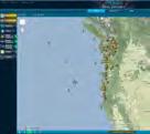
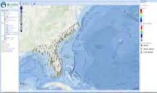
6 NVS: NANOOS Visualization System Washington Line Oregon Line

7 NVS: NANOOS Visualization System Other apps: 7

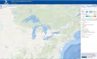
8 NERACOOS Real-time Data Portal Federal : USGS Tides NOAA Buoys NOS Tides NERRS NDBC C-MAN 8 Regional: Gulf of Maine Array CDIP Buoys Long Island Sound Array MVCO Sea Node International : Environment Canada Buoys

9 NERACOOS Model Forecast/Observation Tool 9

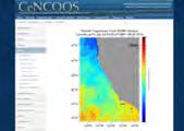
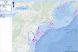
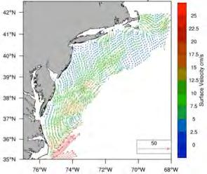
10 MARACOOS Asset Explorer A view of HF Radar surface currents: Numerous in-situ and spatial observations, model output available

11 NOAA National Network: HF Radar
12 NOAA National Network - THREDDS Operational server for HF Radar: dataset=hfradar_usegc_6km

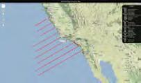
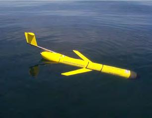
13 MARACOOS Glider Access
14 Machine-Machine Data Discovery and Access Discovery: The Open Geospatial Consortium Catalog Service for the Web (CSW) provides standardized services for search. Primary interface standard in use across IOOS/DMAC participants. Query a CSW using a geographical bounding box, a time range, and a variable of interest CSWs: NCEI geoportal, GEOSS, NASA GCMD NCEI Geoportal: Data can be easily queried and accessed using Python tools Tutorial provided: Access: OPeNDAP+CF conventions Sensor Observation Service (SOS) 14

15 NCEI Catalog discover assets 15


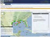
16 Use Case: 2015 Boston Light Swim, Aug 15, 7:00 am, 8 miles, no wet suit How cold will the water be? -- Look for SST model output near stations 16
. https://github.")
17 IPython Notebook - Data Discovery and Access Create a filter for the search Set bounding box, timeframe, find observations in a CSW (Geoportal) Search the catalog for available services (SOS and OPeNDAP)

18 IPython Notebook - Data Discovery and Access Geographical locations of select stations and nearby model outputs matching the search criteria 18

19 IPython Notebook - Data Discovery and Access 19


20 IPython Notebook: Data near the Endurance array? Can we get data near the Endurance Array? Create a filter: Define bounding box for the Endurance array, time span of 5 days, variable (SST) Search the NCEI Geoportal (CSW) for available SOS and OPeNDAP services with filter criteria Access via NDBC SOS, and display NDBC partner data Interactive map with results 20
21 How to install IPython, tutorials IOOS GitHub Pages: ioos.github.io/ 21
22 Conclusion IOOS Regional Associations near Pioneer, Endurance: NERACOOS (Northeast) MARACOOS (Mid-Atlantic) NANOOS (Pacific Northwest) IOOS integrates numerous oceanographic datasets and model output Discover via real-time data portals, RA websites, CSW Access via SOS, THREDDS, ERDDAP, data portals Use via client software (Matlab, Python, etc) 22
23 More information ioos.github.io github.com/ioos System Integration Test project test cases presented as IPython notebooks Pyoos Python library for collecting met-ocean observations Conda-recipes (for IOOS packages) 23
How typical are current conditions?
 How typical are current conditions? NANOOS provides many sources of information for those wanting to track oceanographic conditions throughout the NE Pacific Ocean to be able to understand if the current
The Australian Integrated Marine Observing System: Present and Future Possibilities
 The Australian Integrated Marine Observing System: Present and Future Possibilities Roger Proctor, IMOS/eMII emarine Information Infrastructure IMOS is supported by the Australian Government through the
RHOAPS. Real-time Hydrology Ocean Atmosphere Prediction System. Pronunciation: Ropes Motto: More than just THREDDS
 RHOAPS Real-time Hydrology Ocean Atmosphere Prediction System Pronunciation: Ropes Motto: More than just THREDDS Key Aspects Integrated real-time data systems Atmospheric Hydrologic Coastal oceans Societal
HAB Forecaster. For info on HABs in the Pacific Northwest see:
 HAB Forecaster BACKGROUND In this activity, students can take on the role as a resource manager or scientist, tasked with deciding if razor clam harvesters should go out onto the beach to harvest razor
OCEANOGRAPHIC DATA MANAGEMENT
 OCEANOGRAPHIC DATA MANAGEMENT Presented to: Environmental Disaster Data Management Meeting Russ Beard Director, National Coastal Data Development Center Interim Science Coordinator, Gulf Restoration Council
Ocean Observatories Initiative. Oscar Schofield Rutgers University. Ocean Leadership October 2010
 Ocean Observatories Initiative Oscar Schofield Rutgers University Ocean Leadership October 2010 What is OOI? THE VISION To launch an era of scientific discovery across and within the ocean basins, utilizing
Using netcdf and HDF in ArcGIS. Nawajish Noman Dan Zimble Kevin Sigwart
 Using netcdf and HDF in ArcGIS Nawajish Noman Dan Zimble Kevin Sigwart Outline NetCDF and HDF in ArcGIS Visualization and Analysis Sharing Customization using Python Demo Future Directions Scientific Data
THE USE OF GEOSPATIAL DATA TO SUPPORT VULNERABILITY MAPPING OF THE OREGON COAST. Kelvin Raiford MS Candidate Geography Department of Geosciences
 THE USE OF GEOSPATIAL DATA TO SUPPORT VULNERABILITY MAPPING OF THE OREGON COAST Kelvin Raiford MS Candidate Geography Department of Geosciences INTRODUCTION This study is an outcome of the project Geospatial
The Index to Marine and Lacustrine Geological Samples
 The Index to Marine and Lacustrine Geological Samples Community access to common information on sample collections Kelly J. Stroker 1, Jennifer Jencks 2 1 Cooperative Institute for Research in Environmental
an accessible interface to marine environmental data Russell Moffitt
 an accessible interface to marine environmental data Russell Moffitt The Atlas Project GOAL: To provide a single point of access to oceanographic and environmental data for use by marine resource researchers,
Telepresence In The Ocean
 The Ocean Observatories Initiative: Establishing A Sustained And Adaptive Telepresence In The Ocean Shelby Walker (1) (1) National Oceanic and Atmospheric Administration, Office of Oceanic and Atmospheric
Towards a Web MetOcean Model Map Service (WM3S) profile of WMS
 profile of WMS") Towards a Web MetOcean Model Map Service (WM3S) profile of WMS This is great...... but we are still confused What a mess... WMS? The MetOcean Spatial Data Infrastructure Why WMS? Current system works Production
Towards a Web MetOcean Model Map Service (WM3S) profile of WMS This is great...... but we are still confused What a mess... WMS? The MetOcean Spatial Data Infrastructure Why WMS? Current system works Production
OSU Ocean Observing Center
 OSU Ocean Observing Center and The Ocean Observatories Initiative OSU Retirement Association March 10,19 2016 2 Early Ocean Observations OSU Retirement Association March 10,19 2016 3 No information off
Climate Data for Non-experts: Standards-based Interoperability
 Climate Data for Non-experts: Standards-based Interoperability Ben Domenico Unidata Program Center University Corporation for Atmospheric Research April 2010 Working Together on A Mosaic for Atmospheric
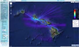
Northwestern Hawaiian Islands Coral Reef Research Partnership: Ocean Mapping, Ecosystem Threats, and Information Management
 Northwestern Hawaiian Islands Coral Reef Research Partnership: Ocean Mapping, Ecosystem Threats, and Information Management Malia Chow Papahanaumokuakea Marine National Monument National Oceanic and Atmospheric
Discovery and Access of Geospatial Resources using the Geoportal Extension. Marten Hogeweg Geoportal Extension Product Manager
 Discovery and Access of Geospatial Resources using the Geoportal Extension Marten Hogeweg Geoportal Extension Product Manager DISCOVERY AND ACCESS USING THE GEOPORTAL EXTENSION Geospatial Data Is Very
Data Management for Algal Monitoring in the Gulf of Mexico
 Data Management for Algal Monitoring in the Gulf of Mexico Scott Cross NOAA National Oceanographic Data Center/ Coastal Data Development Center (NCDDC) Outline History Current & Future Directions Needs
Who is TPAC? TPAC. Located at University of Tasmania, Hobart Partnership between: University of Tasmania CSIRO Marine Atmos. Res.
 Who is? Tasmanian Partnership for Advanced Computing Partner in ARCS (Australian Research Collaboration Services Strengths, Earth Systems Science, Compute and storage facilities Located at University of
MACOORA Theme/MARCOOS Capabilities Product Matrix
 Validation Validation Adaptive Sampling 1 A) BACKGROUND MACOORA Theme/MARCOOS Capabilities Product Matrix B) GOALS AND OBJECTIVES MARACOOS = MACOORA + MARCOOS + Enhancements 1. Regional Management Regional
THE WASHINGTON COASTAL ATLAS
 THE ICAN COASTAL ATLAS MEDIATOR PROTOTYPE AND CONNECTING THE WASHINGTON COASTAL ATLAS Liz O Dea 1, Yassine Lassoued 2, Tanya Haddad 3, Declan Dunne 2 1 GIS Services Unit, WA State Dept. of Ecology 2 Coastal
The Field Research Facility, Duck, NC Warming Ocean Observations and Forecast of Effects
 The Field Research Facility, Duck, NC Warming Ocean Observations and Forecast of Effects A potential consequence of a warming ocean is more frequent and more intense wind events (Hurricanes & Typhoons)
Appendix E: Oceanographic Databases
 Appendix E: Oceanographic Databases Many of the principal U.S. and international database depositories for worldwide ocean observations are listed below, as are a few technical reports with descriptions
Ocean Observatories: Evolution and Future Directions Steven G. Ackleson Consortium for Ocean Leadership Washington, DC
 Ocean Observatories Initiative Ocean Observatories: Evolution and Future Directions Steven G. Ackleson Consortium for Ocean Leadership Washington, DC sackleson@oceanleadership.org O cean Ob serv a to ry
The National Data Buoy Center: Strategic Ocean Observations and International Collaboration
 2011 International Union of Geodesy and Geophysics General Assembly July 1, 2011 The National Data Buoy Center: Strategic Ocean Observations and International Collaboration William Burnett, Richard Bouchard,
NOKIS - Information Infrastructure for the North and Baltic Sea
 NOKIS - Information Infrastructure for the North and Baltic Sea Carsten Heidmann 1 and Jörn Kohlus 2 Abstract 1. General The initial motivation for the project NOKIS (German title: Nord- und Ostsee-Küsteninformationssystem)
BRINGING MARINE DATA ASSETS TO THE FUTURE INTERNET
 ENVIROfying the Future Internet BRINGING MARINE DATA ASSETS TO THE FUTURE INTERNET Leveraging the Future Internet for the Marine Usage Area Dr.Conor Delaney Galway Bay Smart Bay - Ireland MARINE SCENARIOS
Mid course Progress and Opportunities for Unidata Outreach. Ben Domenico May 2011
 Mid course Progress and Opportunities for Unidata Outreach Ben Domenico May 2011 Outline Overview Relationship to Unidata 2013 Proposal Collaborating Communities Recent Progress Current Focus Future Directions
Studying the Ocean Using Live Data
 Studying the Ocean Using Live Data Overview The Argo buoy project is a major oceanographic study that harnesses the power of automated unmanned buoys traveling the world s oceans (http://www.argo.ucsd.edu/).
OOI Regional Scale Node. + bits on Coastal & CI
 OOI Regional Scale Node + bits on Coastal & CI Ron Johnson UW & Pacific Wave Trying to channel John Orcutt, John Delany, Matt Arrott et al Nov. 13, 2009 Ocean Sciences: Theory. Experiment. Observation.
From the Venice Lagoon Atlas towards a collaborative federated system
 From the Venice Lagoon Atlas towards a collaborative federated system City of Venice Alessandro Mulazzani CORILA Consortium for Coordination of Research Activities Concerning the Venice Lagoon System ISMAR-CNR
Please give me the background details of the warning system the US had before and the new improvements now.
 ----- Original Message ----- From: VADM Conrad C. Lautenbacher Jr., USN (Ret.) To: Announcement@noaa.gov Sent: Friday, January 28, 2005 1:30 PM Subject: Message from the Under Secretary -- NOAA Tsunami
HFR Surface Currents Observing System in Lower Chesapeake Bay and Virginia Coast
 HFR Surface Currents Observing System in Lower Chesapeake Bay and Virginia Coast Larry P. Atkinson, Teresa Garner, and Jose Blanco Center for Coastal Physical Oceanography Old Dominion University Norfolk,
Proper Data Management Responsibilities to Meet the Global Ocean Observing System (GOOS) Requirements
 Requirements") Data Buoy Cooperation Panel XXVI Oban, Scotland, UK 27 September 2010 Proper Data Management Responsibilities to Meet the Global Ocean Observing System (GOOS) Requirements William Burnett Data Management
Data Buoy Cooperation Panel XXVI Oban, Scotland, UK 27 September 2010 Proper Data Management Responsibilities to Meet the Global Ocean Observing System (GOOS) Requirements William Burnett Data Management
ALASKA OCEAN OBSERVING SYSTEM 2016 ANNUAL IMPACT REPORT
 ALASKA OCEAN OBSERVING SYSTEM 2016 ANNUAL IMPACT REPORT 1 ALASKA OCEAN OBSERVING SYSTEM 2016 ANNUAL IMPACT REPORT 2 ALASKA OCEAN OBSERVING SYSTEM 2016 ANNUAL IMPACT REPORT Letter from Executive Director
Use of Satellite Earth Observations, in situ data and numerical model capabilities for oil spill contingency. Page 1
 Use of Satellite Earth Observations, in situ data and numerical model capabilities for oil spill contingency Page 1 Oil spill service Page 2 Interest of Earth-Observation (EO) data for oil and gas companies
Operational Estuarine & Coastal Forecast Systems in NOAA s. National Ocean Service
 Operational Estuarine & Coastal Forecast Systems in NOAA s. National Ocean Service Eugene Wei, Frank Aikman III and Richard Patchen NOAA S S National Ocean Service Workshop on: Data Assimilation in Support
Abstract. Introduction
 Building Tsunami Analysis Tools into a GIS Workspace Nazila Merati, NOAA/PMEL/JISAO/UW Seattle, WA 1 Edison Gica, NOAA/PMEL/JISAO/UW Seattle, WA Chris Chamberlin, NOAA/PMEL/JISAO/UW Seattle, WA Abstract
1) make sure folks know what s available in terms of geospatial data and resources that could contribute to their decision support toolkits;
 make sure folks know what s available in terms of geospatial data and resources that could contribute to their decision support toolkits;") Introduction 1 2001 It was born out of the recognition that several of the regions prominent resource management agencies have similar, if not shared, requirements for GIS data. Some of the underlying
Introduction 1 2001 It was born out of the recognition that several of the regions prominent resource management agencies have similar, if not shared, requirements for GIS data. Some of the underlying
NANOOS. Issue 1.1 Safe and efficient commercial shipping and recreational boating.
 BUILD-OUT PLAN FOR NANOOS PART ONE: ISSUES AND PRODUCT TEMPLATES 1. MARINE OPERATIONS Issue 1.1 Safe and efficient commercial shipping and recreational boating. The PNW is a vital hub of maritime transportation
Ocean Currents Student Activity Book
 Ocean Currents Student Activity Book I. Introduction Ocean currents influence the weather in coastal areas. They also influence sailing vessels. Though they visibly affect many people's lives, they are
Spatial data interoperability and INSPIRE compliance the platform approach BAGIS
 Spatial data interoperability and INSPIRE compliance the platform approach BAGIS BAGIS Voluntary, independent, public, non-profit organization; Organization with main mission to promote the growth of the
GIS at UCAR. The evolution of NCAR s GIS Initiative. Olga Wilhelmi ESIG-NCAR Unidata Workshop 24 June, 2003
 GIS at UCAR The evolution of NCAR s GIS Initiative Olga Wilhelmi ESIG-NCAR Unidata Workshop 24 June, 2003 Why GIS? z z z z More questions about various climatological, meteorological, hydrological and
Yi Chao Jet Propulsion Laboratory California Institute of Technology & Joint Institute for Regional Earth System Science and Engineering (JIFRESSE)
") Strategy to Develop a 3D Ocean Circulation Forecasting System for Cook Inlet Yi Chao Jet Propulsion Laboratory California Institute of Technology & Joint Institute for Regional Earth System Science and
Strategy to Develop a 3D Ocean Circulation Forecasting System for Cook Inlet Yi Chao Jet Propulsion Laboratory California Institute of Technology & Joint Institute for Regional Earth System Science and
Flood and Sea Level Rise Mapping Methodologies: The Way Forward
 Flood and Sea Level Rise Mapping Methodologies: The Way Forward Malcolm L. Spaulding Professor Emeritus, Ocean Engineering University of Rhode Island spaulding@egr.uri.edu Interagency Coordination Meeting
METOC at Defence Center for Operational Oceanography (FCOO)
") METOC at Defence Center for Operational Oceanography (FCOO) Forsvarets Center for Operativ Oceanografi Dr. Johan Söderqvist Oceanographer jos@fcoo.dk FCOO Staff (13 pos.) Geophysical expertise: oceanography,
METOC at Defence Center for Operational Oceanography (FCOO) Forsvarets Center for Operativ Oceanografi Dr. Johan Söderqvist Oceanographer jos@fcoo.dk FCOO Staff (13 pos.) Geophysical expertise: oceanography,
NOAA/OAR Observing Systems
 NOAA/OAR Observing Systems Dr. Christopher L. Sabine Director NOAA s Pacific Marine Environmental Laboratory Workshop on Hydroclimate Monitoring Systems and Measurement Needs June, 2014 Global Ocean Observing
NOAA Inundation Dashboard
 NOAA Inundation Dashboard Audra Luscher & Paul Fanelli NOS Center for Operational Oceanographic Products & Services (CO-OPS) Hampton Roads Sea Level Rise/Flooding Adaptation Forum July 29, 2016 http://tidesandcurrents.noaa.gov/inundationdb/newyork.html
Can buoys predict hurricanes? Objectives Students will be able to: track drifter buoys determine the course of the gulf stream current
 Drifters Can buoys predict hurricanes? Objectives Students will be able to: track drifter buoys determine the course of the gulf stream current Materials computers with Internet access Student Worksheet
WERA Ocean Radar Capability of Real-Time Tsunami Detection
 WERA Ocean Radar Capability of Real-Time Tsunami Detection Dr. Anna Dzvonkovskaya Helzel Messtechnik GmbH Kaltenkirchen, GERMANY e-mail: dzvonkovskaya@helzel.com member of and Worldwide WERA HF Ocean Radar
Serving Marine-Related Users in the Mid-Atlantic through Ocean Observing and Forecasting
 MIDDLE ATLANTIC REGIONAL ASSOCIATION COASTAL OCEAN OBSERVING SYSTEM DC MD 1000 km Cape to Cape PA DE NJ CT RI MA Cape Cod NY 10 States and D.C 111 Congressional Districts Serving Marine-Related Users in
U.S. Arctic Campaign Scenario
 Prepared by the NOAA Office of Ocean Exploration and Research for Nation Ocean Exploration Forum 2016: Beyond the Ships. Sea ice extent from National Snow Service Layer Credits: NOAA National Centers for
What s new in GIS. RAL Retreat Oct 5, 2005
 What s new in GIS RAL Retreat Oct 5, 2005 Overview GIS Initiative milestones Major activities in 2004-2005 GALEON UNIDATA OGC project New functionality in ESRI software GIS Initiative Team Olga Wilhelmi
Arctic Spatial Data Infrastructure
 Arctic Spatial Data Infrastructure à Enabling Access to Arctic Land and Marine Data Across Borders, Across Time Simon Riopel, GeoConnections Canada Centre for Mapping and Earth Observation Draft Outline
Collaborative Systems for the Creation of Marine Services
 Collaborative Systems for the Creation of Marine Services INSPIRE 2016 Nuno Almeida Nuno Catarino Barcelona, 28 th September 2016 Elecnor Deimos is a trademark which encompasses Elecnor Group companies
Conrad Blucher Institute for Surveying and Science
 d James Rizzo Assistant irector of Operations - Office: 361-825-5758 Mobile: 361-549-5120 james.rizzo@tamucc.edu d d Texas Coastal Ocean Observation N Network (TCOON) Began in 1988 with 2 stations in Bay
The NOAA Meteorological Assimilation Data Ingest System (MADIS)
") The NOAA Meteorological Assimilation Data Ingest System (MADIS) Patricia A. Miller, Michael F. Barth, Leon A. Benjamin, Randall S. Collander, Thomas B. Kent, and Gopa Padmanabhan (OAR/ESRL/GSD) Steven
The NOAA Meteorological Assimilation Data Ingest System (MADIS) Patricia A. Miller, Michael F. Barth, Leon A. Benjamin, Randall S. Collander, Thomas B. Kent, and Gopa Padmanabhan (OAR/ESRL/GSD) Steven
The Delaware Environmental Monitoring & Analysis Center
 The Delaware Environmental Monitoring & Analysis Center Tina Callahan Delaware Estuary Science & Environmental Summit 2013 January 27-30, 2013 What is DEMAC? Delaware Environmental Monitoring & Analysis
Northrop Grumman Concept Paper
 Northrop Grumman Concept Paper A Comprehensive Geospatial Web-based Solution for NWS Impact-based Decision Support Services Glenn Higgins April 10, 2014 Northrop Grumman Corporation Information Systems
IOOS Regional Associations Collaborations with NOAA's National Weather Service
 IOOS Regional Associations Collaborations with NOAA's National Weather Service Updated October 2011 Most of the 11 IOOS Regional Associations work with the NWS field offices. These collaborations include
Image Services Providing Access to Scientific Data at NOAA/NCEI
 Image Services Providing Access to Scientific Data at NOAA/NCEI Jesse Varner Cooperative Institute for Research in Environmental Sciences (CIRES), University of Colorado John Cartwright NOAA National Centers
Evolution of NOAA s Observing System Integrated Analysis (NOSIA)
") Evolution of NOAA s Observing System Integrated Analysis (NOSIA) Presented to the 13th Symposium on Societal Applications: Policy, Research and Practice (paper 9.1) Louis Cantrell Jr., and D. Helms, R.
Evolution of NOAA s Observing System Integrated Analysis (NOSIA) Presented to the 13th Symposium on Societal Applications: Policy, Research and Practice (paper 9.1) Louis Cantrell Jr., and D. Helms, R.
Regional Spatial Data Infrastructures What Makes them Possible?
 Article for Geoinformatics June 2007 Regional Spatial Data Infrastructures What Makes them Possible? by Sam Bacharach Executive Director Outreach Open Geospatial Consortium, Inc. (OGC) INTRODUCTION The
Bathymetry. EMODnet Stakeholder Conference & Sea-basin Workshops February Bathymetry
 EMODnet Stakeholder Conference & Sea-basin Workshops 14-15 February 2017 Arctic checkpoint Belinda Kater On behalf of all Checkpoints http://www.emodnet.eu 1 ? is the study of the "beds" or "floors" of
SAWS: Met-Ocean Data & Infrastructure in Support of Industry, Research & Public Good. South Africa-Norway Science Week, 2016
 SAWS: Met-Ocean Data & Infrastructure in Support of Industry, Research & Public Good South Africa-Norway Science Week, 2016 Marc de Vos, November 2016 South Africa: Context http://learn.mindset.co.za/sites/default/files/resourcelib/e
SOP of PTWC as a Regional Tsunami Service Provider
 UNESCO IOC CTIC US NOAA ITIC Regional Training Workshop on Strengthening Tsunami Warning and Emergency Response Standard Operating Procedures and the Development of the ICG/CARIBE-EWS PTWC New Enhanced
FOURTH INTERNATIONAL PORT METEOROLOGICAL OFFICERS WORKSHOP AND SUPPORT TO GLOBAL OCEAN OBSERVATIONS USING SHIP LOGISTICS
 FOURTH INTERNATIONAL PORT METEOROLOGICAL OFFICERS WORKSHOP AND SUPPORT TO GLOBAL OCEAN OBSERVATIONS USING SHIP LOGISTICS PMO-IV 8-10 DEC 2010, ORLANDO, FLORIDA, USA 1 This presentation is generally for
An easy-to-use application that lets end users prepare and deploy background maps to your Carmenta based applications.
 Introducing Carmenta Map Builder An easy-to-use application that lets end users prepare and deploy background maps to your Carmenta based applications. Carmenta s geospatial technology is known for its
The Coastal Field Data Collection Program (CFDC) Waves & Coastal Observations for the Corps and the Nation
 Waves & Coastal Observations for the Corps and the Nation") The Coastal Field Data Collection Program (CFDC) Waves & Coastal Observations for the Corps and the Nation Bill Birkemeier Program Manager William.Birkemeier@usace.army.mil 10 August 2010 US Army Corps
The Coastal Field Data Collection Program (CFDC) Waves & Coastal Observations for the Corps and the Nation Bill Birkemeier Program Manager William.Birkemeier@usace.army.mil 10 August 2010 US Army Corps
Northwest Association of Networked Ocean Observing Systems The Integrated Ocean Observing System (IOOS) Regional Association for the Pacific NW
 Regional Association for the Pacific NW") Northwest Association of Networked Ocean Observing Systems The Integrated Ocean Observing System (IOOS) Regional Association for the Pacific NW www.nanoos.org U.S. Integrated Ocean Observing System (IOOS)
Northwest Association of Networked Ocean Observing Systems The Integrated Ocean Observing System (IOOS) Regional Association for the Pacific NW www.nanoos.org U.S. Integrated Ocean Observing System (IOOS)
Water Data Sharing an Update
 Water Data Sharing an Update By David R. Maidment Leader, CUAHSI Hydrologic Information System Project and Director, Center for Research in Water Resources, University of Texas at Austin Prepared for Subcommittee
12/2/15. Providing observa.ons, data and informa.on products to meet agency and stakeholder needs
 12/2/15 Providing observa.ons, data and informa.on products to meet agency and stakeholder needs 1 Part of the Integrated Ocean Observing System (IOOS) Governed through a Memorandum of Agreement Fiscal
Unidata: An Overview. Tom Yoksas. Unidata Program Center / UCAR Boulder, Colorado USA
 Unidata: An Overview Tom Yoksas Unidata Program Center / UCAR Boulder, Colorado USA http://www.unidata.ucar.edu Unidata - Principle Activities Providing Tools to visualize, analyze, organize, receive,
The EOC Geoservice: Standardized Access to Earth Observation Data Sets and Value Added Products
 The EOC Geoservice: Standardized Access to Earth Observation Data Sets and Value Added Products Klaus Dengler, Torsten Heinen, Albert Huber, Katrin Molch, Eberhard Mikusch DLR German Remote Sensing Data
WaveNet: A Web-Based Metocean Data Access, Processing and Analysis Tool; Part 5 WW3 Database
 WaveNet: A Web-Based Metocean Data Access, Processing and Analysis Tool; Part 5 WW3 Database by Zeki Demirbilek, Lihwa Lin, Derek Wilson, and Jay Rosati PURPOSE: This Coastal and Hydraulics Engineering
Key Points Sharing fosters participation and collaboration Metadata has a big role in sharing Sharing is not always easy
 Sharing Resources Geoff Mortson esri, Inc. SDI Solutions Team Key Points Sharing fosters participation and collaboration Metadata has a big role in sharing Sharing is not always easy Data Sharing is Good
WGISS-39 Tsukuba, Japan. RESTEC Kaori Kuroiwa
 CEOS Water Portal Overview and Status Update WGISS-39 Tsukuba, Japan JAXA Shinichi i SEKIOKA RESTEC Kaori Kuroiwa Contents 1. Overview (just a reminder ) 2. Updates New Architecture Development 3. Future
Technical Specifications. Form of the standard
 Used by popular acceptance Voluntary Implementation Mandatory Legally enforced Technical Specifications Conventions Guidelines Form of the standard Restrictive Information System Structures Contents Values
West Florida Shelf and Tampa Bay Responses to Hurricane Irma: What Happened and Why
 West Florida Shelf and Tampa Bay Responses to Hurricane Irma: What Happened and Why R.H. Weisberg Y. Liu J. Chen College of Marine Science University of South Florida St. Petersburg, FL SECOORA Webinar
Global Geospatial Information Management Country Report Finland. Submitted by Director General Jarmo Ratia, National Land Survey
 Global Geospatial Information Management Country Report Finland Submitted by Director General Jarmo Ratia, National Land Survey Global Geospatial Information Management Country Report Finland Background
Using the EartH2Observe data portal to analyse drought indicators. Lesson 4: Using Python Notebook to access and process data
 Using the EartH2Observe data portal to analyse drought indicators Lesson 4: Using Python Notebook to access and process data Preface In this fourth lesson you will again work with the Water Cycle Integrator
Portals: Standards in Action
 Portals: Standards in Action David Danko ISO TC 211 Metadata Project Leader GIS Standards Consultant-ESRI. Metadata Portals Portal gateway, place of entry Producers Advertise, expose products Share information
Introduction: The Gulf of Mexico Alliance. The Gulf GAME project MERMAid and PHINS Results & Conclusions What s next? Examples
 AAG Las Vegas March 25, 2009 Introduction: Ocean governance and Ecosystem-Based Management The Gulf of Mexico Alliance Habitat Identification and Characterization The Gulf GAME project MERMAid and PHINS
Monitoring the coastal ocean: from local to regional
 Monitoring the coastal ocean: from local to regional Luísa Bastos University of Porto / CIIMAR RAIA partners Ocean monitoring To answer key societal and scientific challenges navigation safety, fisheries,
Finnish Open Data Portal for Meteorological Data
 18.11.2013 1 Finnish Open Data Portal for Meteorological Data 14th Workshop on meteorological operational systems Roope Tervo Finnish Meteorological Institute Example of Data Sets -- Observations Data
Discovery and Access to Global Water Data, Maps and Services
 Discovery and Access to Global Water Data, Maps and Services David K. Arctur, PhD david.arctur@utexas.edu University of Texas at Austin Open Geospatial Consortium (OGC) Esri International User Conference
: : User Manual: : - 10 December
 : : User Manual: : - 0 December 06 - : : User Manual: : Table of Contents. Map Control. How to move a map. How to zoom in and out a map 4. How to inquire Ocean Currents. How to inquire predicted current
Ocean Observatories Initiative
 Ocean Observatories Initiative Pioneer Array Micro-Siting Process Meeting URI Coastal Institute November 15, 2010 Jean McGovern, NSF Al Plueddemann, WHOI Action Items from 5 Oct Meeting NSF will address
v=7tat9croynk&feature=youtu.be
 https://www.youtube.com/watch? v=7tat9croynk&feature=youtu.be Malta Summer School 2018 Operational Oceanography for Blue Growth EMODnet in a nutshell: unlocking, and offering access to, European marine
Portal for ArcGIS: An Introduction
 Portal for ArcGIS: An Introduction Derek Law Esri Product Management Esri UC 2014 Technical Workshop Agenda Web GIS pattern Product overview Installation and deployment Security and groups Configuration
The Open Geospatial Consortium and EarthCube
 The Open Geospatial Consortium and EarthCube An EarthCube Technology Paper Prepared by David Maidment 1, Ben Domenico 2, Alastair Gemmell 3, Kerstin Lehnert 4, David Tarboton 5 and Ilya Zaslavsky 6 Introduction
Altimetry for Coastal Applications. Paul M. DiGiacomo and Amanda Bittinger NOAA CoastWatchatch Program 5 February 2008
 Altimetry for Coastal Applications Paul M. DiGiacomo and Amanda Bittinger NOAA CoastWatchatch Program 5 February 2008 IGOS COASTAL THEME REPORT Published January 2006, IOC http://www.igospartners.org/d
Overview of Geospatial Open Source Software which is Robust, Feature Rich and Standards Compliant
 Overview of Geospatial Open Source Software which is Robust, Feature Rich and Standards Compliant Cameron SHORTER, Australia Key words: Open Source Geospatial Foundation, OSGeo, Open Standards, Open Geospatial
Bathymetric Attributed Grids (BAGs): Discovery of Marine Datasets and Geospatial Metadata Visualization
: Discovery of Marine Datasets and Geospatial Metadata Visualization") University of New Hampshire University of New Hampshire Scholars' Repository Center for Coastal and Ocean Mapping Center for Coastal and Ocean Mapping 2010 Bathymetric Attributed Grids (BAGs): Discovery
University of New Hampshire University of New Hampshire Scholars' Repository Center for Coastal and Ocean Mapping Center for Coastal and Ocean Mapping 2010 Bathymetric Attributed Grids (BAGs): Discovery
Some of the underlying goals of the GIS Library are to:
 1 2001 It was born out of the recognition that several of the regions prominent resource management agencies have similar, if not shared, requirements for GIS data. Some of the underlying goals of the
CGSN Overview. GSN Sites CSN Sites Shore Facilities
 GSN Sites CSN Sites Shore Facilities CGSN Overview Coastal Pioneer Array Endurance Array Global Irminger Sea Southern Ocean Station Papa Fixed assets Surface mooring Subsurface mooring Mobile assets Ocean
Building a National Data Repository
 Building a National Data Repository Mladen Stojic, Vice President - Geospatial 1/30/2013 2012 Intergraph Corporation 1 Information has meaning and gives power only when shared and distributed. Information,
10/23/09. Environmental data and data sources. Outline. I. Data generalities. 1. Data types
 10/23/09 Environmental data and data sources Outline Daniel Palacios NOAA/SWFSC Mark Baumgartner NOAA/SWFSC Cara Wilson Dave Foley Roy Mendelssohn NOAA/SWFSC I. Data generalities III. Data access I. Data
Comparison of NYHOPS hydrodynamic model SST predictions with satellite observations in the Hudson River tidal, estuarine, and coastal plume region
 Comparison of NYHOPS hydrodynamic model SST predictions with satellite observations in the Hudson River tidal, estuarine, and coastal plume region Abstract Shashi Bhushan 1, Alan F. Blumberg 2, Nickitas
Geodesy. orientation. shape. gravity field
 Geodesy noun Science of measuring the shape, orientation and gravity field of the Earth and how it changes over time. shape orientation gravity field Positioning has always been important Downstream applications
Introduction to Portal for ArcGIS. Hao LEE November 12, 2015
 Introduction to Portal for ArcGIS Hao LEE November 12, 2015 Agenda Web GIS pattern Product overview Installation and deployment Security and groups Configuration options Portal for ArcGIS + ArcGIS for