Spatial data interoperability and INSPIRE compliance the platform approach BAGIS
|
|
|
- Loreen Edwards
- 6 years ago
- Views:
Transcription

1 Spatial data interoperability and INSPIRE compliance the platform approach BAGIS


2 BAGIS Voluntary, independent, public, non-profit organization; Organization with main mission to promote the growth of the GIS society in Bulgaria and support the development and use of GIS in Bulgaria;
3 BAGIS Main goals To help create effective conditions for wider deployment and use of GIS and GI; Provide knowledge and information on GIS and GI; Encourage the creation of GIS applications, as well as the use of GIS and GIs and related technologies.
4 BAGIS Main goals To promote and support GIS education, scientific and innovation practices in the sphere; To promote dialogue between the public and private sector on GIS issues; To help create GIS legislation, policies, strategies and plans;
5 BAGIS Main goals Provide appropriate information to its members and act as a catalyst for new opportunities in their work; Work to improve the qualifications of Geospatial Information Systems specialists; Many more


6 Integrated processes for using spatial data Applications Processing Creation Data production Work processes Publishing Detection Services Use Visualization Products and services Analysis End users Data collection


7 Use Case: I want to find data Solution: Simple keyword Search Spatial search Federated Search Advanced options for experts Smart matching and ranking Thesaurus Service Search results are simple to understand yet contain detail for power users


8 Use Case: I don t want to search though Solution: Analogous to Department Store Implementer Organizes Hierarchy (Facets) Based on Metadata Content Filter/Paginate Within Category Classification and Relationships


9 Use Case: I want to make a map Solution: Preview services: - ArcGIS Server Map Services - OGC WMS, SOS - GeoRSS - KML Provide integration points for map viewer platforms - Web AppBuilder - ArcGIS.com Viewer - JavaScript, Flex, Silverlight - ArcGIS Desktop ArcMap - ArcGIS Explorer


10 Use Case: I want to download data Solution: Based on Clip-Zip-Ship Service - Select area - Select data - Set options Deliver download link through Extensible in Python
11 Use Case: I want to share my resource Solution: Register Servers or Services Directly Create metadata online Upload metadata Register catalog service for harvesting Support metadata standards: - INSPIRE - North American Profile - Dublin Core - Configurable


12 Use Case: Is new data is available? Solution: User specifies search criteria Give user link to a GeoRSS feed User subscribes to GeoRSS feed Bookmark searches in the browser

13 Welcome to My World Documents INSPIRE ISO CGDI GEMINI FGDC THREDDS OGC GEOSS W3C ArcGIS Online ATOM SPARQL CS-W Geoplatform.gov Measurements ANSI NEN ANZLIC Features ebrim Images OpenSearch DCAT Portal for ArcGIS
14 Typically Organization is a System of Systems HydroPortal ArcGIS Online Data.gov NOAA Geoplatform OER YouTube NOAA YouTube NCDC NGDC NCDDC OER NOS A CSC SECART B = A searches B NODC IOCM CMGDS USGS.gov

15 Metadata Portal Author Serve Discover Use

16 Why does open data matter? transparency accountability open data participation innovation economic development
17 Using Open Data: open data principles Accessible Discoverable Explorable Collaborative
18 User Scenarios Organizations participating in SDI and Large Federal Infrastructures Help me satisfy my obligations (workflows) using mandated standards Organizations participating in Opendata Help me satisfy my obligations Organizations participating in cross-domain, cross organizational workflows Help my workflow. Help me work with my other stakeholders and business entities


19 Open Formats ETL TOOLS OGC Standards Open Data ISO Standards www Standards Open Source INTEROPERABILITY fgdc Standards Open API s Closed Source Extensions ANSI Standards Open Specifications INSPIRE Standards DGIWG Standards Achieving Interoperability


20 Laws Interoperability enablers Supportive networks, Interfaces, hardware Well trained Knowledgeable users Understand the need for quality Metadata to understand and use data and services properly Infrastructure Interoperability Standards Practical, widely used Providing technical and semantic interoperability Fit for purpose Geographic structures Data formats Content description Quality Data management Visualization Geoweb services Metadata Intellectual property protection, Authorization to share


 ISO TC211 Abstract")


21 Standards An agreement between a provider and a consumer a reference document enabling interoperability Standards Development Organizations (SDOs) ISO TC211 Abstract Models, Content, Vocabulary. Software Interfaces: Instantiations based on ISO and W3C standards XML/XSD, HTML, XSLT, URI... Domain Infrastructure

22 Putting it all together THE PLATFORM APPROACH Using standard s functional areas to provide geographic knowledge Basic Geographic Structure Content Description Data Management Data Format Examples: ISO Spatial Schemas ISO Spatial referencing by coordinates ISO Schema for coverage geometry and functions Examples: ISO Rules for Application Schemas ISO Feature Catalog ISO Metadata ISO Classification Systems Visualization Web services Examples: GML, WMS, WCS WFS, MIL-STD 2525

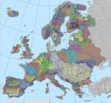
23 EU SPATIAL DATA - Initial assessment 2001г. Needs - Better spatial information for policy implementation - Improvement of the existing GSD information streams - Cross-border exchange of geo-information - Update of the approach from reporting and monitoring to sharing information Situation in Europe - Restrictions on spatial data - Prices, rights, access, licensing policy - Lack of coordination - Across borders - Between the different administrative levels - Lack of standards - Incompatible data and IS - The existing data is not used multiple times - Fragmented information, repeatedly funded July 2004 Offer for INSPIRE Directive November 2006 Political decision 15 May 2007 Enters into force EU has islands of data in different standards and quality.

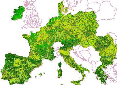
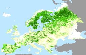
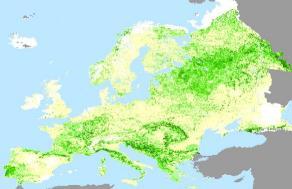


24 INSPIRE GSD institutional frame Technical standards for GSD Basic spatial data sets Spatial data services

25 Problems with the current data sharing method Data actuality Formats Coordinate systems/projections Compatibility Size Lack of metadata Usually require processing of the data before their usage (transformation)
26 Components of the Spatial Data Infrastructure Technology - hardware, GIS software, networks, databases, technical standards Policies & Interdepartmental Agreements - management, rights and data security, data exchange, return on investment People - training, professional development, cooperation, goals` achievement


27 Development of spatial infrastructure in Bulgaria Overview Cadaster Agency Ministry of environment and water Executive Environment Agency Ministry of Defense National Railway Infrastructure OTHERS

28 Geographic Information Systems The necessary technology for building the spatial infrastructure of Bulgaria and meeting the requirements and responsibilities of INSPIRE directive
29 Development of spatial infrastructure in Bulgaria Overview


30 Development of spatial infrastructure in Bulgaria Overview GIS for integrated plans and urban development: Sofia; Varna; Gabrovo; other;

31 Conclusion We have a lot of work to do! INTEGRATED PLATFORM APPROACH MAKES THE RIGHT STEPS FASTER We see the progress

32 Contact us at: Thank you!
Discovery and Access of Geospatial Resources using the Geoportal Extension. Marten Hogeweg Geoportal Extension Product Manager
 Discovery and Access of Geospatial Resources using the Geoportal Extension Marten Hogeweg Geoportal Extension Product Manager DISCOVERY AND ACCESS USING THE GEOPORTAL EXTENSION Geospatial Data Is Very
Key Points Sharing fosters participation and collaboration Metadata has a big role in sharing Sharing is not always easy
 Sharing Resources Geoff Mortson esri, Inc. SDI Solutions Team Key Points Sharing fosters participation and collaboration Metadata has a big role in sharing Sharing is not always easy Data Sharing is Good
Spatial Data Infrastructure Concepts and Components. Douglas Nebert U.S. Federal Geographic Data Committee Secretariat
 Spatial Data Infrastructure Concepts and Components Douglas Nebert U.S. Federal Geographic Data Committee Secretariat August 2009 What is a Spatial Data Infrastructure (SDI)? The SDI provides a basis for
Hosted by Esri Official Distributor
 Hosted by Esri Official Distributor Esri European User Conference October 15-17, 2012 Oslo, Norway Hosted by Esri Official Distributor Interoperability and Standards Support in ArcGIS 10.1 Roberto Lucchi
ArcGIS for INSPIRE. Marten Hogeweg
 ArcGIS for INSPIRE Marten Hogeweg Please Take Our Survey on the App Download the Esri Events app and find your event Select the session you attended Scroll down to find the feedback section Complete answers
INSPIRing Geospatial Framework For Local Administrations
 This project is financed by the European Union and the Republic of Turkey Presented at the FIG Congress 2018, May 6-11, 2018 in Istanbul, Turkey National Programme for Turkey 2010 Instrument for Pre-Accession
Implementing INSPIRE Geoportal in Turkey
 Implementing INSPIRE Geoportal in Turkey Gencay SERTER City and Regional Planner 1 Presentation Plan Introduction INSPIRE and Turkey Importance of al Spatial Planning Portal Logical&Legal Hierarchy GeoPortal
Overview of Geospatial Open Source Software which is Robust, Feature Rich and Standards Compliant
 Overview of Geospatial Open Source Software which is Robust, Feature Rich and Standards Compliant Cameron SHORTER, Australia Key words: Open Source Geospatial Foundation, OSGeo, Open Standards, Open Geospatial
GIS Building Communities beyond National Borders (Building Successful Spatial Data Infrastructures) Nick Land, ESRI Europe
 Nick Land, ESRI Europe") GIS Building Communities beyond National Borders (Building Successful Spatial Data Infrastructures) Nick Land, ESRI Europe UK worst flooding in the last 60 years 350,000 households without drinking water
GIS Building Communities beyond National Borders (Building Successful Spatial Data Infrastructures) Nick Land, ESRI Europe UK worst flooding in the last 60 years 350,000 households without drinking water
ArcGIS for INSPIRE. Marten Hogeweg Satish Sankaran
 ArcGIS for INSPIRE Marten Hogeweg Satish Sankaran Outline What is ArcGIS ArcGIS for INSPIRE Web GIS Case Studies Roadmap Q&A What is INSPIRE? INSPIRE is the legal framework for a European Spatial Data
Technical Specifications. Form of the standard
 Used by popular acceptance Voluntary Implementation Mandatory Legally enforced Technical Specifications Conventions Guidelines Form of the standard Restrictive Information System Structures Contents Values
Portals: Standards in Action
 Portals: Standards in Action David Danko ISO TC 211 Metadata Project Leader GIS Standards Consultant-ESRI. Metadata Portals Portal gateway, place of entry Producers Advertise, expose products Share information
Roadmap to interoperability of geoinformation
 Roadmap to interoperability of geoinformation and services in Europe Paul Smits, Alessandro Annoni European Commission Joint Research Centre Institute for Environment and Sustainability paul.smits@jrc.it
The Process of Spatial Data Harmonization in Italy. Geom. Paola Ronzino
 The Process of Spatial Data Harmonization in Italy Geom. Paola Ronzino ISSUES Geospatial Information in Europe: lack of data harmonization the lack of data duplication of data CHALLENGES Challenge of INSPIRE:
SDI-Challenges European perspective
 THE HIGH LEVEL FORUM ON GLOBAL GEOSPATIAL INFORMATION MANAGEMENT Seoul, Republic of Korea, 24-26 October 2011 Session 1: Challenges in geospatial policy formation and institutional arrangements SDI-Challenges
SDI Standards at work
 SDI Standards at work Jan Juul Jensen Senior Technology Strategist Informi GIS Denmark Informi GIS Private held Limited Company Specialized in GIS 100+ employees HQ in Charlottenlund, Copenhagen Regional
Data Aggregation with InfraWorks and ArcGIS for Visualization, Analysis, and Planning
 Data Aggregation with InfraWorks and ArcGIS for Visualization, Analysis, and Planning Stephen Brockwell President, Brockwell IT Consulting, Inc. Join the conversation #AU2017 KEYWORD Class Summary Silos
European Location Framework data in the ArcGIS platform
 European Location Framework data in the ArcGIS platform Presentation to: Author: Date: INSPIRE Conference 2016 Clemens Portele 26 September 2016 Why ELF? Global (e.g. UN GGIM) Regional Europe (INSPIRE
CHAPTER 22 GEOGRAPHIC INFORMATION SYSTEMS
 CHAPTER 22 GEOGRAPHIC INFORMATION SYSTEMS PURPOSE: This chapter establishes the administration and use of to improve the quality and accessibility of Department s spatial information and support graphical
INSPIRE Shared Service
 INSPIRE Shared Service Creation and operation out of the box Petra Fritz (HZD), Michael Voigtländer (Esri Deutschland GmbH) INSPIRE Shared Service Agenda HZD backbone for a geodata infrastructure Implementing
THE WASHINGTON COASTAL ATLAS
 THE ICAN COASTAL ATLAS MEDIATOR PROTOTYPE AND CONNECTING THE WASHINGTON COASTAL ATLAS Liz O Dea 1, Yassine Lassoued 2, Tanya Haddad 3, Declan Dunne 2 1 GIS Services Unit, WA State Dept. of Ecology 2 Coastal
Enabling Geospatial Killer Apps Interfaces, Visualizations and APIs Imaging the World
 International Open Government Data Conference Enabling Geospatial Killer Apps Interfaces, Visualizations and APIs Imaging the World Jim Barrett, Data.gov Geospatial Architect Pat Cummens, Government Strategist,
ISO Series Standards in a Model Driven Architecture for Landmanagement. Jürgen Ebbinghaus, AED-SICAD
 ISO 19100 Series Standards in a Model Driven Architecture for Landmanagement Jürgen Ebbinghaus, AED-SICAD 29.10.2003 The Company 100% SIEMENS PTD SIEMENS Business Services Shareholder & Strategic Business
Geospatial Standards Support - An Overview. Marten Hogeweg & Satish Sankaran
 Geospatial Standards Support - An Overview Marten Hogeweg & Satish Sankaran Agenda Interoperability and Standards ArcGIS Open, Interoperable and Standards Compliant Esri Open initiatives Understanding
INSPIRE - A Legal framework for environmental and land administration data in Europe
 INSPIRE - A Legal framework for environmental and land administration data in Europe Dr. Markus Seifert Bavarian Administration for Surveying and Cadastre Head of the SDI Office Bavaria Delegate of Germany
Implementing strategy for the Infrastructure for Spatial Information in Europe - INSPIRE Paul Smits
 Implementing strategy for the Infrastructure for Spatial Information in Europe - INSPIRE Paul Smits European Commission DG Joint Research Centre Institute for Environment and Sustainability Ispra, Italy
Environmental Systems Research Institute, Inc.
 Environmental Systems Research Institute, Inc. 380 New York Street Redlands, CA 92373-8100 Telephone: + (909) 793-2853 Facsimile: + (909) 307-3034 Supporting GEOSS Common Architecture and Societal Benefit
Global Geospatial Information Management Country Report Finland. Submitted by Director General Jarmo Ratia, National Land Survey
 Global Geospatial Information Management Country Report Finland Submitted by Director General Jarmo Ratia, National Land Survey Global Geospatial Information Management Country Report Finland Background
These modules are covered with a brief information and practical in ArcGIS Software and open source software also like QGIS, ILWIS.
 Online GIS Training and training modules covered are: 1. ArcGIS, Analysis, Fundamentals and Implementation 2. ArcGIS Web Data Sharing 3. ArcGIS for Desktop 4. ArcGIS for Server These modules are covered
Cadastral Standards & Interoperability
 Cadastral Standards & Interoperability Some Considerations Black Hills Digital Mapping Association September 18, 2007 Jeanne Foust ESRI Spatial Data Infrastructure Global Manager jfoust@esri.com Why is
ArcGIS. for Server. Understanding our World
 ArcGIS for Server Understanding our World ArcGIS for Server Create, Distribute, and Manage GIS Services You can use ArcGIS for Server to create services from your mapping and geographic information system
Spatially Enabled Society
 International Seminar on Land Administration Trends and Issues in Asia and the Pacific Region Spatially Enabled Society Abbas Rajabifard Vice Chair PCGIAP-WG3 Vice-President (President Elect), GSDI Association
INSPIREd solutions for Air Quality problems Alexander Kotsev
 INSPIREd solutions for Air Quality problems Alexander Kotsev www.jrc.ec.europa.eu Serving society Stimulating innovation Supporting legislation The European data puzzle The European data puzzle 24 official
Introduction to Portal for ArcGIS
 Introduction to Portal for ArcGIS Derek Law Product Management March 10 th, 2015 Esri Developer Summit 2015 Agenda Web GIS pattern Product overview Installation and deployment Security and groups Configuration
ELF products in the ArcGIS platform
 ELF products in the ArcGIS platform Presentation to: Author: Date: NMO Summit 2016, Dublin, Ireland Clemens Portele 18 May 2016 The Building Blocks 18 May, 2016 More ELF users through affiliated platforms
Introduction to Portal for ArcGIS. Hao LEE November 12, 2015
 Introduction to Portal for ArcGIS Hao LEE November 12, 2015 Agenda Web GIS pattern Product overview Installation and deployment Security and groups Configuration options Portal for ArcGIS + ArcGIS for
Using OGC standards to improve the common
 Using OGC standards to improve the common operational picture Abstract A "Common Operational Picture", or a, is a single identical display of relevant operational information shared by many users. The
Spatial Analysis with Web GIS. Rachel Weeden
 Spatial Analysis with Web GIS Rachel Weeden Agenda Subhead goes here Introducing ArcGIS Online Spatial Analysis Workflows Scenarios Other Options Resources ArcGIS is a Platform Making mapping and analytics
GeoSUR SRTM 30-m / TPS
 GeoSUR SRTM 30-m / TPS Wm Matthew Cushing (USGS) 16 May 2013 U.S. Department of the Interior U.S. Geological Survey SRTM Mission Shuttle Radar Topography Mission (SRTM) Space Shuttle Endeavour during the
Open spatial data infrastructure
 Open spatial data infrastructure a backbone for digital government Thorben Hansen Geomatikkdagene 2018 Stavanger 13.-15. mars Spatial Data Infrastructure definition the technology, policies, standards,
Portal for ArcGIS: An Introduction
 Portal for ArcGIS: An Introduction Derek Law Esri Product Management Esri UC 2014 Technical Workshop Agenda Web GIS pattern Product overview Installation and deployment Security and groups Configuration
INSPIRE implementation in Portugal: the operational approach
 INSPIRE implementation in Portugal: the operational approach REIS, Rui; SANTOS, Ana Sofia; FONSECA, Alexandra; SILVA, Henrique; GOMES, Ana Luisa; FURTADO, Danilo; GEIRINHAS, João rui.reis@igeo.pt AGENDA
Building a national spatial data infrastructure. Thorben Hansen, Head of Division Danish Agency for Data Supply and Efficiency
 Building a national spatial data infrastructure Thorben Hansen, Head of Division Danish Agency for Data Supply and Efficiency About Spatial Data Infrastructure Spatial data come from many sources and is
The World Bank and the Open Geospatial Web. Chris Holmes
 The World Bank and the Open Geospatial Web Chris Holmes Geospatial is Everywhere QuickTime and a TIFF (Uncompressed) decompressor are needed to see this picture. Spatial Data Infrastructure (SDI) the sources,
Regione Umbria. ESRI EMEA User Conference 2010 Rome, October 27th 2010
 Direzione Ambiente, Territorio e Infrastrutture Servizio Informatico/Informativo: geografico, ambientale e territoriale ESRI EMEA User Conference 2010 Rome, October 27th 2010 Arch. Ambra Ciarapica, Dott.
Innovation. The Push and Pull at ESRI. September Kevin Daugherty Cadastral/Land Records Industry Solutions Manager
 Innovation The Push and Pull at ESRI September 2004 Kevin Daugherty Cadastral/Land Records Industry Solutions Manager The Push and The Pull The Push is the information technology that drives research and
GIS at UCAR. The evolution of NCAR s GIS Initiative. Olga Wilhelmi ESIG-NCAR Unidata Workshop 24 June, 2003
 GIS at UCAR The evolution of NCAR s GIS Initiative Olga Wilhelmi ESIG-NCAR Unidata Workshop 24 June, 2003 Why GIS? z z z z More questions about various climatological, meteorological, hydrological and
Ministry of ICT of I.R.IRAN
 The ECO 8/6 mill km 2 10 Slamic countries ~330 mill people Oil, Gas, Industries,Tourism 2 Issue transformation in last decade Problem solving needs more integrated approach More interaction &complexity
Leveraging Web GIS: An Introduction to the ArcGIS portal
 Leveraging Web GIS: An Introduction to the ArcGIS portal Derek Law Product Management DLaw@esri.com Agenda Web GIS pattern Product overview Installation and deployment Configuration options Security options
INSPIRE and Land Use Planning System in Portugal
 INSPIRE and Land Use Planning System in Portugal Rui Amaro Alves Director General Directorate General for Territorial Development ruialves@dgterritorio.pt Carlos Simões Senior Technician Directorate General
The PREVIEW Global Risk Data Platform: a geoportal to serve and share global data on risk to natural hazards
 The PREVIEW Global Risk Data Platform: a geoportal to serve and share global data on risk to natural hazards Gregory Giuliani (UNEP/GRID-Geneva & University of Geneva/enviroSPACE ) http://www.grid.unep.ch
Demystifying ArcGIS Online. Karen Lizcano Esri
 Demystifying ArcGIS Online Karen Lizcano Esri An Integrated Web GIS Platform Desktop Web Device Powered by Services Managed via Portal Access from any Device Portal Server Online Content and Services ArcGIS
Standards in Action: The Canadian Geospatial Data Infrastructure (CGDI)
") Standards in Action: The Canadian Geospatial Data Infrastructure (CGDI) Craig Stewart ISO/TC211 Standards in Action Workshop, September 14, 2005 Presentation Outline Overview of SDIs Overview of Canada
Standards in Action: The Canadian Geospatial Data Infrastructure (CGDI) Craig Stewart ISO/TC211 Standards in Action Workshop, September 14, 2005 Presentation Outline Overview of SDIs Overview of Canada
Proposal for a DIRECTIVE OF THE EUROPEAN PARLIAMENT AND OF THE COUNCIL. establishing an infrastructure for spatial information in the Community
 Proposal for a DIRECTIVE OF THE EUROPEAN PARLIAMENT AND OF THE COUNCIL establishing an infrastructure for spatial information in the Community INSPIRE http://inspire.jrc.it/ Alessandro Annoni 1 EU Commission
Geospatial SDI Portal for effective Governance of Pune METROPOLIS region
 Geospatial SDI Portal for effective Governance of Pune METROPOLIS region Mr. Praveen Gautam Senior Manager 19 th January 2018 PMRDA Overview Provide a Spatial Framework for the entire region with various
Oman NSDI Business Values and Future Directions. Hassan Alawi Alghazali Acting Director General National Spatial Data Infrastructure
 Oman NSDI Business Values and Future Directions Hassan Alawi Alghazali Acting Director General National Spatial Data Infrastructure Presentation Outline Geospatial Maturity Current Challenges NCSI s Role
DP Project Development Pvt. Ltd.
 Dear Sir/Madam, Greetings!!! Thanks for contacting DP Project Development for your training requirement. DP Project Development is leading professional training provider in GIS technologies and GIS application
Demonstration of a local SDI solution with several stakeholders in pilot areas in line with EU best practices
 EU Twinning project for the Agency of Land Relations and Cadaster (ALRC)- Organization, Streamlining and Computerization Process in Mapping in the Republic of Moldova. Demonstration of a local SDI solution
ArcGIS is Advancing. Both Contributing and Integrating many new Innovations. IoT. Smart Mapping. Smart Devices Advanced Analytics
 ArcGIS is Advancing IoT Smart Devices Advanced Analytics Smart Mapping Real-Time Faster Computing Web Services Crowdsourcing Sensor Networks Both Contributing and Integrating many new Innovations ArcGIS
INDONESIA S S UPDATE: GEOSPATIAL INFORMATION FOR SUSTAINABLE DEVELOPMENT RELATED TO INA SDI Dr. Asep Karsidi, M.Sc
 INDONESIA S S UPDATE: GEOSPATIAL INFORMATION FOR SUSTAINABLE DEVELOPMENT RELATED TO INA SDI Dr. Asep Karsidi, M.Sc GEOSPATIAL INFORMATION AGENCY 08 August, 2012 OUTLINE 1. Transformation Bakosurtanal into
Spatial Data Availability Energizes Florida s Citizens
 NASCIO 2016 Recognition Awards Nomination Spatial Data Availability Energizes Florida s Citizens State of Florida Agency for State Technology & Department of Environmental Protection Category: ICT Innovations
Ready for INSPIRE.... connecting worlds. European SDI Service Center
 Ready for INSPIRE Consultancy SOFTWARE T r a i n i n g Solutions... connecting worlds European SDI Service Center Increasing Added Value with INSPIRE and SDI Components INSPIRE In 2007, the European Commission
Oman NSDI Supporting Economic Development. Saud Al-Nofli Director of Spatial Data Directorate General of NSDI, NCSI
 Oman NSDI Supporting Economic Development 2017 Saud Al-Nofli Director of Spatial Data Directorate General of NSDI, NCSI "It s critical to make correct decisions the first time to optimize the Investments
Major Opportunities in Spatial Data Infrastructure Communities
 Major Opportunities in Spatial Data Infrastructure Communities Bas Kok President GSDI June 17 th 2008 FIG Working Week: Integrating Generations 14-19 June 2008 Stockholm, Sweden http://www.gsdi.org 1 GSDI
INSPIRE Basics. Vlado Cetl European Commission Joint Research Centre. https://ec.europa.eu/jrc/
 INSPIRE Basics Vlado Cetl European Commission Joint Research Centre https://ec.europa.eu/jrc/ Serving society Stimulating innovation Supporting legislation Outline SDI? Why European SDI? INSPIRE Policy
The Global Statistical Geospatial Framework and the Global Fundamental Geospatial Themes
 The Global Statistical Geospatial Framework and the Global Fundamental Geospatial Themes Sub-regional workshop on integration of administrative data, big data and geospatial information for the compilation
No. of Days. Building 3D cities Using Esri City Engine ,859. Creating & Analyzing Surfaces Using ArcGIS Spatial Analyst 1 7 3,139
 Q3 What s New? Creating and Editing Data with ArcGIS Pro Editing and Maintaining Parcels Using ArcGIS Spatial Analysis Using ArcGIS Pro User Workflows for ArcGIS Online Organizations Q3-2018 ArcGIS Desktop
Digital Map of Mexico Platform and MxSIG. March 2017
 Digital Map of Mexico Platform and MxSIG March 2017 1 I. Digital Map of Mexico Platform Concept Evolution II. Digital Map of Mexico online Concept Capabilities Information available Other state units information
CLICK HERE TO KNOW MORE
 CLICK HERE TO KNOW MORE GeoSpace for Singapore s Whole-of-Government Data Sharing Asia GeoSpatial Forum 17 19 Oct 2011 Lee Kim Haw Singapore Land Authority Introducing Singapore Land Authority Limited
IRDAT Fvg, evolving a regional Spatial Data Infrastructure according to INSPIRE
 IRDAT Fvg, evolving a regional Spatial Data Infrastructure according to INSPIRE Tutti i diritti riservati. Proprietà INSIEL SpA. A. Benvenuti, A. Chiarandini Insiel (Italy) M. Lunardis - Friuli Venezia
Evaluating e-government : implementing GIS services in Municipality
 Evaluating e-government : implementing GIS services in Municipality Municipality of Thessaloniki - G.I.S. Unit Misirloglou Symeon Head of the GIS Unit ESRI UC - 2016 The GIS Section - subset of the department
REGION AND STATES INTERCONNEXIONS : CRIGE PACA, SWISSTOPO AND FRENCH PORTALS. Dr. C. Giger (swisstopo) S. Maffren (CRIGE PACA) D.
 S. Maffren (CRIGE PACA) D.") REGION AND STATES INTERCONNEXIONS : CRIGE PACA, SWISSTOPO AND FRENCH PORTALS Dr. C. Giger (swisstopo) S. Maffren (CRIGE PACA) D. Richard (IGN) Components to connect PACA portal French Geoportal Local datasets
REGION AND STATES INTERCONNEXIONS : CRIGE PACA, SWISSTOPO AND FRENCH PORTALS Dr. C. Giger (swisstopo) S. Maffren (CRIGE PACA) D. Richard (IGN) Components to connect PACA portal French Geoportal Local datasets
Technical Framework Methodology as a core of building up the NSDI NSDI Implementation Specifics in Serbia
 Technical Framework Methodology as a core of building up the NSDI NSDI Implementation Specifics in Serbia Luka Jovičić SDI Consultant@ Gramont Ltd. Aleksandar Dedić RGA NSDI department Dragica Pajić RGA
SWEDISH SDI DEVELOPMENT & IMPLEMENTATION OF INSPIRE
 SWEDISH SDI DEVELOPMENT & IMPLEMENTATION OF INSPIRE Christina Wasström, Lantmäteriet, 801 82 Gävle, Sweden, christina.wasstrom@lm.se ABSTRACT The Swedish Government and Parliament has given Lantmäteriet
Institute of Statistical and Geographical Information of Jalisco State Subnational Statistical and Geographical System India.
 Institute of Statistical and Geographical Information of Jalisco State Subnational Statistical and Geographical System India. January 2017 Subnational Statistical and Geographical System National Statistical
Establishing the National Spatial Data Infrastructure (NSDI) for Norway a joint effort by many stakeholders SPATIAL DATA FOR BENEFIT OF THE SOCIETY
 for Norway a joint effort by many stakeholders SPATIAL DATA FOR BENEFIT OF THE SOCIETY") Establishing the National Spatial Data Infrastructure (NSDI) for Norway a joint effort by many stakeholders SPATIAL DATA FOR THE BENEFIT OF SOCIETY OUTLINE Political background Norway digital - The Norwegian
Establishing the National Spatial Data Infrastructure (NSDI) for Norway a joint effort by many stakeholders SPATIAL DATA FOR THE BENEFIT OF SOCIETY OUTLINE Political background Norway digital - The Norwegian
ArcGIS for INSPIRE. Paul Hardy. ArcGIS. ArcGIS for INSPIRE Enables Esri ArcGIS users to implement and comply with INSPIRE. INSPIRE Data Themes
 Enables Esri ArcGIS users to implement and comply with INSPIRE Paul Hardy phardy@esri.com EuroGeographics INSPIRE KEN (Schema Transformation) 8/9 October 2013, Marne la Vallée INSPIRE Data Themes Annex
Building a National Data Repository
 Building a National Data Repository Mladen Stojic, Vice President - Geospatial 1/30/2013 2012 Intergraph Corporation 1 Information has meaning and gives power only when shared and distributed. Information,
EuroSDR (European Spatial Data Research)
") EuroSDR (European Spatial Data Research) ROLLING RESEARCH PLAN 2015-2018 EuroSDR Secretariat Public Governance Institute KU Leuven Parkstraat 45 bus 3609 3000 Leuven Belgium Tel.: +32 16 32 31 80 Fax:
EuroSDR (European Spatial Data Research) ROLLING RESEARCH PLAN 2015-2018 EuroSDR Secretariat Public Governance Institute KU Leuven Parkstraat 45 bus 3609 3000 Leuven Belgium Tel.: +32 16 32 31 80 Fax:
Charter for the. Information Transfer and Services Architecture Focus Group
 for the Information Transfer and Services Architecture Focus Group 1. PURPOSE 1.1. The purpose of this charter is to establish the Information Transfer and Services Architecture Focus Group (ITSAFG) as
EXPECTATIONS OF TURKISH ENVIRONMENTAL SECTOR FROM INSPIRE
 EXPECTATIONS OF TURKISH ENVIRONMENTAL SECTOR FROM INSPIRE June, 2010 Ahmet ÇİVİ Tuncay DEMİR INSPIRE in the Eyes of MoEF Handling of Geodata by MoEF Benefits Expected TEIEN First Steps for INSPIRE Final
Reducing Consumer Uncertainty
 Spatial Analytics Reducing Consumer Uncertainty Eliciting User and Producer Views on Geospatial Data Quality Introduction Cooperative Research Centre for Spatial Information (CRCSI) in Australia Communicate
Web 3D Service & CityGML Update
 Technische Universität Berlin Web 3D Service & CityGML Update Thomas H. Kolbe Institute for Geodesy and Geoinformation Science Berlin University of Technology kolbe@igg.tu-berlin.de 2nd of November, 2007
The state-of-the-art of the Finnish SDI. Arctic SDI WG Meeting
 The state-of-the-art of the Finnish SDI Arctic SDI WG Meeting Moscow 8.9.2011 Esa Tiainen Development Centre 1 NATIONAL LAND SURVEY DOWN TO EARTH Contents Legal framework Coordination structure Network
How does ArcGIS Server integrate into an Enterprise Environment? Willy Lynch Mining Industry Specialist ESRI, Denver, Colorado USA
 How does ArcGIS Server integrate into an Enterprise Environment? Willy Lynch Mining Industry Specialist ESRI, Denver, Colorado USA wlynch@esri.com ArcGIS Server Technology Transfer 1 Agenda Who is ESRI?
GeoSpace for Singapore s Whole-of-Government Data Sharing
 GeoSpace for Singapore s Whole-of-Government Data Sharing Ng Siau Yong, Lim Ming Khai, Lo Jing Lu & Anupam Mukherjee ABSTRACT Sharing of land information among government agencies is not new to Singapore.
Esri and GIS Education
 Esri and GIS Education Organizations Esri Users 1,200 National Government Agencies 11,500 States & Regional Agencies 30,800 Cities & Local Governments 32,000 Businesses 8,500 Utilities 12,600 NGOs 11,000
Innovation in Land Management: Integrated Solutions For National Cadastre Projects
 Success With GIS Innovation in Land Management: Integrated Solutions For National Cadastre Projects XXIII International FIG Congress Munich These documents are only complete, when used in connection with
Norwegian spatial data infrastructure supporting disaster risk management Norwegian Mapping Authority
 Norwegian spatial data infrastructure supporting disaster risk management Norwegian Mapping Authority Arvid Lillethun, Norwegian Mapping Authority Land and Poverty 2018 Conference, World Bank 19.-23. March
Pushing the Standards Edge: Collaborative Testbeds to Accelerate Standards Development and Implementation
 Pushing the Standards Edge: Collaborative Testbeds to Accelerate Standards Development and Implementation Mark E. Reichardt President mreichardt@opengeospatial.org 31 October 2006 2006 Open Geospatial
Zagreb Spatial Data Infrastructure. Sanja Batić, APIS IT Split, 14. rujna 2011.
 Zagreb Spatial Data Infrastructure Sanja Batić, APIS IT Split, 14. rujna 2011. Agenda Zagreb Spatial Data Infrastructure - ZIPP Guidelines for further ZIPP Geoportal development Conclusion 1964 The Centre
Ministry of Health and Long-Term Care Geographic Information System (GIS) Strategy An Overview of the Strategy Implementation Plan November 2009
 Strategy An Overview of the Strategy Implementation Plan November 2009") Ministry of Health and Long-Term Care Geographic Information System (GIS) Strategy An Overview of the Strategy Implementation Plan November 2009 John Hill, Health Analytics Branch Health System Information
Ministry of Health and Long-Term Care Geographic Information System (GIS) Strategy An Overview of the Strategy Implementation Plan November 2009 John Hill, Health Analytics Branch Health System Information
Marine Spatial Management Tool
 Marine Spatial Management Tool Marine Spatial Management Tool Support the marine spatial planning process with updated and reliable geospatial information Marine management is important to Norway with
Sharing soil information with the help of INSPIRE, key challenges with soil data management
 Sharing soil information with the help of INSPIRE, key challenges with soil data management Katharina Feiden e-mail: gssoil@portalu.de GS Soil: project outline GS Soil: Assessment and strategic development
Portal for ArcGIS: An Introduction. Catherine Hynes and Derek Law
 Portal for ArcGIS: An Introduction Catherine Hynes and Derek Law Agenda Web GIS pattern Product overview Installation and deployment Configuration options Security options and groups Portal for ArcGIS
The future of SDIs. Ian Masser
 The future of SDIs Ian Masser Presentation Considers two questions relating to the future development of SDIs throughout the world Where have we got to now? Where should we go from here? Identifies four
Marine Spatial Planning, a Norwegian user case NSHC33
 Marine Spatial Planning, a Norwegian user case NSHC33 Marine Spatial Management Tool Support the marine spatial planning process with updated and reliable geospatial information Marine management is important
GIS-based Smart Campus System using 3D Modeling
 GIS-based Smart Campus System using 3D Modeling Smita Sengupta GISE Advance Research Lab. IIT Bombay, Powai Mumbai 400 076, India smitas@cse.iitb.ac.in Concept of Smart Campus System Overview of IITB Campus
ESRI Delivering geographic information systems to millions of users
 Using Web GIS to Track Government Spending and Performance Eric Floss - ESRI April 12, 2010 ESRI Delivering geographic information systems to millions of users GIS Is Changing Everything How We Reason
Status of implementation of the INSPIRE Directive 2016 Country Fiches. COUNTRY FICHE Ireland
 Status of implementation of the INSPIRE Directive 2016 Country Fiches COUNTRY FICHE Ireland Introduction... 1 1. State of Play... 2 1.1 Coordination... 2 1.2 Functioning and coordination of the infrastructure...