Discovery and Access to Global Water Data, Maps and Services
|
|
|
- Steven Harrison
- 5 years ago
- Views:
Transcription
 Esri International User Conference July")
1 Discovery and Access to Global Water Data, Maps and Services David K. Arctur, PhD University of Texas at Austin Open Geospatial Consortium (OGC) Esri International User Conference July 2014
2 Why is it so important to share water data? Improving agriculture Water quality Managing the economics and conflicts of shared access Understanding, predicting and mitigating drought and flooding Learning patterns of natural variability Within and across watersheds Along coastlines Anticipating and mitigating other natural and manmade disasters Debris flows, toxic spills Helping improve skills in developing countries Understanding global water cycle Using standards lowers costs and learning curves for equipment, software development, tools, training, and maintenance
3 GEOSS Introduction GEOSS: Global Earth Observation System of Systems Hosted by GEO (Group on Earth Observations) to publish Earth observation datasets from 92 member countries GEO home page: GEOSS search portal: Enables distributed search among dozens of catalogs, accessing millions of data services, following international data exchange standards (ISO, WMO, OGC, ) Data is organized around 9 Societal Benefit Areas (SBAs): Water, Weather, Climate, Biodiversity, Ecosystems, Energy, Agriculture, Health, Disasters GEOSS AIP (Architecture Implementation Pilot) Series of 1-year project cycles to implement GEOSS, started in 2007; AIP-6 now complete; AIP-7 just started
4 AIP-6 Water Services (2013): Key Concepts Current international standards work mainly at the Internet level, still need refining for consistency of terms and usage within and across international hydrology communities This project has made water data sharing easier, through: 1. Improved discovery and access to water time series data, across domain-community resources 2. Integration of gridded & time series data sources 3. Enabling federation of regional & national water data around a common information model and service architecture

5 Useful organizing principle and registry for cross-community resources:

6 GEOSS Portal: connecting to community portals and other resources

7 CEOS Community Portal Committee on Earth Observation Satellites,
 Canadian Monitoring Network New Zealand Government Network CEOS Water Portal (JAXA, Univ of Tokyo DIAS) Esri ArcGIS")
8 Water Community Portals added in AIP-6 CUAHSI HIS Central (moved and being updated to OGC standards) ISPRA Monitoring Network (Italy) Canadian Monitoring Network New Zealand Government Network CEOS Water Portal (JAXA, Univ of Tokyo DIAS) Esri ArcGIS Online
9 Next step is from community portals to water data maps GEOSS and community portals provide coverage and download access to data services and data sets For water observation data that are time series, a more convenient way of visualizing the data services is with maps of the monitoring points These can be browsed at the monitoring station level, grouped by various means, and selected for data downloads
10
 Click to add layers 1. WMO GRDC (gauge descriptions only, no water data) 2.")
 5. Dominican Republic (historical data hosted by BYU) 6.")
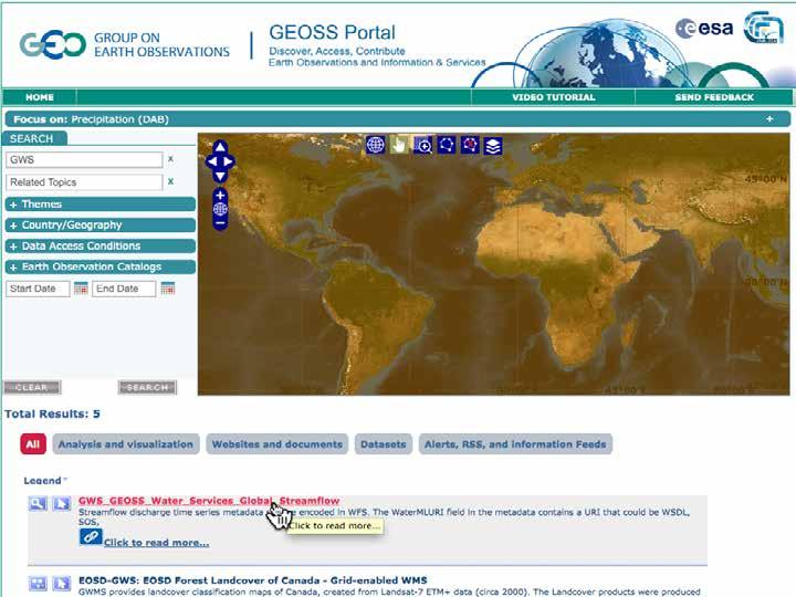
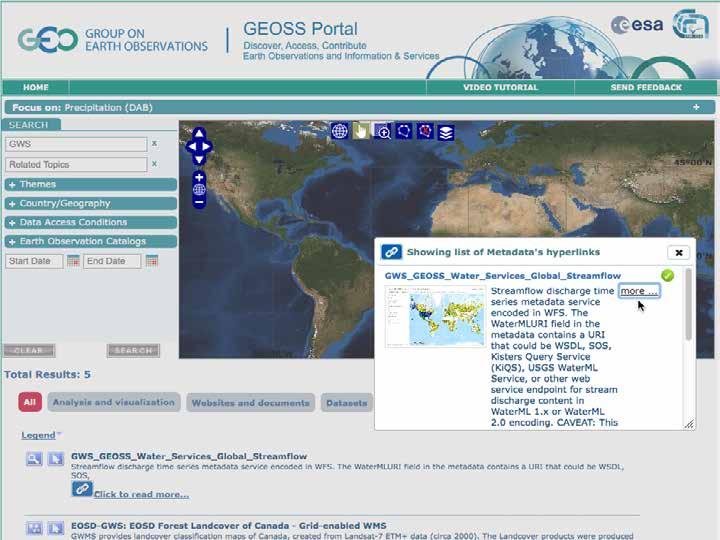
11 Water Data Maps: Global Stream Gauges Not just seeing data providers bounding boxes, but actual locations of specific data (Esri ArcGIS Online web map viewer) Click to add layers 1. WMO GRDC (gauge descriptions only, no water data) 2. Kisters GRDC (WaterML 2 data for OGC Surface Water IE) 3. USGS NWIS (most have real-time data) 4. Mexico (some with historical data, hosted by Univ of Texas) 5. Dominican Republic (historical data hosted by BYU) 6. Italy & New Zealand (real-time data, developed for AIP-6)


12 Gauge description and data links For quick overview For easy analysis WaterML for full details


13 WaterML 2.0 Document metadata Observation description - Phenomena time - Result time - Procedure - Observed property - Feature of interest - Result - Time series metadata - Time series data Time series data, cont d
 This grid is from the Land Data Assimilation System (LDAS) Other gridded variables are planned for future")
14 2. Integrated gridded & time series data sources Many data sources and model-output are created as continuous grids of a variable over the earth at a point in time NASA is integrating soil moisture grids to generate time series at discrete locations (data rods) This grid is from the Land Data Assimilation System (LDAS) Other gridded variables are planned for future projects

15 Viewing & comparing time series values Gridded map at timestamp Time series & stats at grid point
16 3. Federating regional & national water data All the mechanisms described so far make access easier, but don t address a fundamental issue: conventions for information content Without consistent use of standards for data content and description, every water management agency would have a different way of telling their story In this project, we have started convergence toward a common way of describing water data time series among these countries: United States (USGS NWIS) Italy (ISPRA/ARPA-ER) New Zealand (NIWA/HRC) Canada (USask GIWS for Environment Canada) Dominican Republic (through BYU) Honduras (through BYU) Nicaragua (through BYU) Guatemala (through BYU)
17 Summary of Recommendations 1. Use OGC WaterML 2 for water-variable time series data (streamflow, precipitation, runoff, etc). 2. Use OGC WFS or similar feature layer of water data sites; one WFS service per data layer / producer. 3. Use consistent & minimal subset of time series description fields in the WFS data service (this is a current discussion topic). 4. Use OGC SOS 2 as the web data service for WaterML 2, but be prepared for the many sites running CUAHSI WaterOneFlow (WOF) web service for WaterML 1.x data, and even WFS for WaterML time series data. Use ISO 8601 for time expressions in the data service. 5. Each data provider could install and manage a catalog registry of relevant time series descriptions (WFS feature layers), or use an established community catalog for that purpose (eg, CUAHSI HIS Central). This catalog should itself be registered in GEOSS. WMO is advancing that the core WaterML be renamed TimeSeriesML, and the hydrology-specific portion (still to be called WaterML) become a profile of TimeSeriesML.
18 Behind the map 1 Request data about [observed property] (CSW) Catalog of Data Providers gauge layers Community Web Portal Discovery, Access and Visualization 2 Return list of Data Providers map layers 6 Return time series data or graph (WaterML, CSV) 5 Request data service for time series of selected gauge 3 Request map from each Data Provider about [observed property] 4 Return gauge locations as a map layer (GML SF) (SOS) Data service for time series at one gauge (WFS) Map of gauges (one layer per observed property) for one Data Provider
")
19 GEOSS promotes interdisciplinary discovery GEOSS By registering the community portal and its catalog in GEOSS, interdisciplinary users can more easily discover these resources Community Web Portal Discovery, Access and Visualization (CSW) Catalog of Data Providers gauge layers (SOS) Data service for time series at one gauge (WFS) Map of gauges (one layer per observed property) for one Data Provider
20 Started April 2014: AIP-7 Water Services Project Develop more application-oriented scenarios around water quality observations, flood monitoring, prediction, and damage assessment. Capacity building in Latin America, through cooperation with the Latin American Development Bank / GeoSUR

21 Past The Dartmouth Flood Observatory preserves the record of each major flood event, for posterity, and for use in global flood hazard modeling..

22 Current DFO provides ongoing flood delineation from remote sensing (NASA MODIS)
 Output: global daily discharge")
 ECMWF VAREPS for forecasts since June 2011 Spatial resolution")
23 Future - GloFAS Inputs: global spatial data Digital elevation Hydro-Meteo model with grid-based routing (LisFlood) Output: global daily discharge Land use ECMWF ERA-INTERIM Re-ANALYSIS for discharge climatology ( ) ECMWF VAREPS for forecasts since June 2011 Spatial resolution 0.1 degree


24 Future - GloFAS GloFAS provides probabilistic forecasts of flooding events for large basins, based on 4-yr historical data
25 AIP-7 Water Services Team (* new members) Academic University of Texas at Austin, USA Brigham Young University, USA University of Saskatchewan, Canada Feng Chia University, Taiwan * George Mason University, USA * Community Labs, Portals CUAHSI Water Data Center Dartmouth Flood Observatory * CEOS Water Portal (JAXA) NASA Goddard Hydrological Science Lab NASA Goddard Earth Sciences DISC German Federal Institute of Hydrology * EC Joint Research Centre (JRC) UK Centre for Ecology and Hydrology * European Centre for Midrange Weather Forecasting (ECMWF) Latin American Development Bank & Pan American Institute of Geography & History *
26 AIP-7 Water Services Team National and regional agencies Italian National Institute for Environmental Protection and Research (ISPRA) Regional Agency for Environmental Protection in Emilia-Romagna (ARPA-ER), Italy New Zealand National Institute of Water and Atmospheric Research (NIWA) Horizons Regional Council (HRC), New Zealand Commercial Engineering & Software Esri Kisters AG
27 Thank you! David K. Arctur
Advancing Flood Detection and Preparedness through GEOSS Water Services
 Advancing Flood Detection and Preparedness through GEOSS Water Services David K. Arctur University of Texas at Austin Open Geospatial Consortium (OGC) CAHMDA/DAFOH Joint Workshop University of Texas at
The CUAHSI Hydrologic Information System
 The CUAHSI Hydrologic Information System Presented by Dr. Tim Whiteaker The University of Texas at Austin 18 November, 2010 Session T1B About the Speaker PhD 2004 Research Associate What You Will Learn
Global Flood Awareness System GloFAS
 Global Flood Awareness System GloFAS Ervin Zsoter with the help of the whole EFAS/GloFAS team Ervin.Zsoter@ecmwf.int 1 Reading, 8-9 May 2018 What is GloFAS? Global-scale ensemble-based flood forecasting
Explore African and Global early warning systems Climate Change effects on water cycle: Flood Risk. Revised website:
 JRC research activities on floods 1 Flood early warning (Europe) EFAS: European Flood Alert System IMPRINTS (DG RTD project): flash flood early warning EU-FLOOD-GIS ETN-R Explore African and Global early
RHOAPS. Real-time Hydrology Ocean Atmosphere Prediction System. Pronunciation: Ropes Motto: More than just THREDDS
 RHOAPS Real-time Hydrology Ocean Atmosphere Prediction System Pronunciation: Ropes Motto: More than just THREDDS Key Aspects Integrated real-time data systems Atmospheric Hydrologic Coastal oceans Societal
European Drought Observatory Progress on Drought Monitoring
 European Drought Observatory Progress on Drought Monitoring Alfred de Jager Diego Magni European Commission Joint Research Centre (JRC) Disaster Risk Management Unit Outline 1. Introduction Philosophy
I&CLC2000 in support to new policy initiatives (INSPIRE, GMES,..)
") I&CLC2000 in support to new policy initiatives (INSPIRE, GMES,..) Manfred Grasserbauer, Director Joint Research Centre Institute for Environment and Sustainability 1 IMAGE 2000 European mosaic of satellite
I&CLC2000 in support to new policy initiatives (INSPIRE, GMES,..) Manfred Grasserbauer, Director Joint Research Centre Institute for Environment and Sustainability 1 IMAGE 2000 European mosaic of satellite
The Global Runoff Data Centre (GRDC) Report on selected GRDC activities during the inter-sessional period Ulrich Looser
 Report on selected GRDC activities during the inter-sessional period Ulrich Looser") The Global Runoff Data Centre (GRDC) Report on selected GRDC activities during the inter-sessional period 2008-2012 Ulrich Looser Koblenz 09/2012 1 1. Introduction This report summarises some of the activities
The Global Runoff Data Centre (GRDC) Report on selected GRDC activities during the inter-sessional period 2008-2012 Ulrich Looser Koblenz 09/2012 1 1. Introduction This report summarises some of the activities
Water Data Sharing an Update
 Water Data Sharing an Update By David R. Maidment Leader, CUAHSI Hydrologic Information System Project and Director, Center for Research in Water Resources, University of Texas at Austin Prepared for Subcommittee
National Flood Interoperability Experiment
 National Flood Interoperability Experiment David R. Maidment, University of Texas at Austin Catchment-based Hydrological Data Assimilation (CAHMDA) VI Conference 8 September 2014 Located on Tuscaloosa
The Global Flood Awareness System
 The Global Flood Awareness System David Muraro, Gabriele Mantovani and Florian Pappenberger www.globalfloods.eu 1 Forecasting chain using Ensemble Numerical Weather Predictions Flash Floods / Riverine
EuroGEOSS for Drought - Linking the European Drought Observatory to global and local scales
 EuroGEOSS for Drought - Linking the European Drought Observatory to global and local scales Barbara Hofer, Stefan Niemeyer, EC-JRC INSPIRE Conference 2010 Cracow June 24, 2010 Drought Relevance Droughts
United States Multi-Hazard Early Warning System
 United States Multi-Hazard Early Warning System Saving Lives Through Partnership Lynn Maximuk National Weather Service Director, Central Region Kansas City, Missouri America s s Weather Enterprise: Protecting
GIS in Weather and Society
 GIS in Weather and Society Olga Wilhelmi Institute for the Study of Society and Environment National Center for Atmospheric Research WAS*IS November 8, 2005 Boulder, Colorado Presentation Outline GIS basic
Group on Earth Observations (GEO) Cold Regions Work Plan Item WA-01-C3
 Cold Regions Work Plan Item WA-01-C3") EC Panel of Experts on Polar Observations, Research and Services Group on Earth Observations (GEO) Cold Regions Work Plan Item WA-01-C3 Barbara J. Ryan Secretariat Director Lanzhou, China 13 March 2013
EC Panel of Experts on Polar Observations, Research and Services Group on Earth Observations (GEO) Cold Regions Work Plan Item WA-01-C3 Barbara J. Ryan Secretariat Director Lanzhou, China 13 March 2013
ECWMF Workshop Providing Tailor-made Forecasts to the Community. Jim Nelson BYU Michael Souffront Many Others ECMWF, NASA, Esri, NOAA, and many more
 ECWMF Workshop Providing Tailor-made Forecasts to the Community Jim Nelson BYU Michael Souffront Many Others ECMWF, NASA, Esri, NOAA, and many more Stakeholders They Make the Decisions Spatial Databases
Transboundary water management with Remote Sensing. Oluf Jessen DHI Head of Projects, Water Resources Technical overview
 Transboundary water management with Remote Sensing Oluf Jessen DHI Head of Projects, Water Resources Technical overview ozj@dhigroup.com Transboundary water management Water management across national
Land Accounts - The Canadian Experience
 Land Accounts - The Canadian Experience Development of a Geospatial database to measure the effect of human activity on the environment Who is doing Land Accounts Statistics Canada (national) Component
EuroGEOSS Protected Areas Pilot
 EuroGEOSS Protected Areas Pilot Max Craglia European Commission Joint Research Centre Part 1: the present MyNatura2000 Mobile app. Awareness raising & volunteered data collection. Natura2000 covers 18%
GIS at UCAR. The evolution of NCAR s GIS Initiative. Olga Wilhelmi ESIG-NCAR Unidata Workshop 24 June, 2003
 GIS at UCAR The evolution of NCAR s GIS Initiative Olga Wilhelmi ESIG-NCAR Unidata Workshop 24 June, 2003 Why GIS? z z z z More questions about various climatological, meteorological, hydrological and
WGISS-39 Tsukuba, Japan. RESTEC Kaori Kuroiwa
 CEOS Water Portal Overview and Status Update WGISS-39 Tsukuba, Japan JAXA Shinichi i SEKIOKA RESTEC Kaori Kuroiwa Contents 1. Overview (just a reminder ) 2. Updates New Architecture Development 3. Future
INSPIREd solutions for Air Quality problems Alexander Kotsev
 INSPIREd solutions for Air Quality problems Alexander Kotsev www.jrc.ec.europa.eu Serving society Stimulating innovation Supporting legislation The European data puzzle The European data puzzle 24 official
SuperPack North America
 SuperPack North America Speedwell SuperPack makes available an unprecedented range of quality historical weather data, and weather data feeds for a single annual fee. SuperPack dramatically simplifies
Bringing it all together. David R. Maidment Texas Water Forum 13 February 2012
 Bringing it all together David R. Maidment Texas Water Forum 13 February 2012 What have I learned today? Texas drought is very complex On a physical level as to causes in the atmosphere and their translation
Contribution to global Earth observation from satellites
 Contribution to global Earth observation from satellites - JAXA s Earth Observation strategy - April 16, 2008 Makoto Kajii Japan Aerospace Exploration Agency Earth Observation Summits and GEOSS 1 st EO
Hands On Applications of the Latin American and Caribbean Flood and Drought Monitor (LACFDM)
") Hands On Applications of the Latin American and Caribbean Flood and Drought Monitor (LACFDM) Colby Fisher, Eric F Wood, Justin Sheffield, Nate Chaney Princeton University International Training: Application
Hands On Applications of the Latin American and Caribbean Flood and Drought Monitor (LACFDM) Colby Fisher, Eric F Wood, Justin Sheffield, Nate Chaney Princeton University International Training: Application
The Open Geospatial Consortium and EarthCube
 The Open Geospatial Consortium and EarthCube An EarthCube Technology Paper Prepared by David Maidment 1, Ben Domenico 2, Alastair Gemmell 3, Kerstin Lehnert 4, David Tarboton 5 and Ilya Zaslavsky 6 Introduction
Historical background
 Space Technology for Disaster Management in Sri Lanka: Country profile, national perspectives & vision. Professor Ranjith Premalal De Silva Vice Chancellor Uva Wellassa University of Sri Lanka October
The Open Geospatial Consortium and EarthCube
 The Open Geospatial Consortium and EarthCube An EarthCube Technology Paper Prepared by David Maidment 1, Ben Domenico 2, Alastair Gemmell 3, Kerstin Lehnert 4, David Tarboton 5 and Ilya Zaslavsky 6 Introduction
ADVANTAGES OF GIS-INTEGRATED MARITIME DATA IN THE BLACK SEA REGION FOR MULTIPURPOSE USE
 INTERAGENCY INTERACTION IN CRISIS MANAGEMENT AND DISASTER RESPONSE 2017 ADVANTAGES OF GIS-INTEGRATED MARITIME DATA IN THE BLACK SEA REGION FOR MULTIPURPOSE USE Lyubka Pashova 1, Anna Kortcheva 2, Vasko
Model Calibration and Forecast Error for NFIE-Hydro
 Corey Van Dyk C E 397 Flood Forecasting 5/8/15 Model Calibration and Forecast Error for NFIE-Hydro Introduction The forecasting component of the National Flood Interoperability Experiment (NFIE), like
Amita Mehta and Ana Prados
 Building Capacity in Utilizing NASA Remote Sensing Observations in SWAT for Water Resources and Agricultural Management Applications Amita Mehta and Ana Prados NASA - University of Maryland Baltimore County
THE WASHINGTON COASTAL ATLAS
 THE ICAN COASTAL ATLAS MEDIATOR PROTOTYPE AND CONNECTING THE WASHINGTON COASTAL ATLAS Liz O Dea 1, Yassine Lassoued 2, Tanya Haddad 3, Declan Dunne 2 1 GIS Services Unit, WA State Dept. of Ecology 2 Coastal
SDI and Beyond The Importance of Standards and Interoperability For Good Governance; Selected Examples
 SDI and Beyond The Importance of Standards and Interoperability For Good Governance; Selected Examples Trevor Taylor, Director, Member Services, Asia and the Americas Sao Paulo May 7 th, 2014 Why is Geospatial
Services for Inland Marine Data Integration. USGS Center for Integrated
 Services for Inland Marine Data Integration USGS Center for Integrated Data Analytics Outline GeoDataPortal Tools Coastal Use Cases Beach hhealth lthmodeling Distributed Rainfall Analysis for Integration
Geohazard Supersites and Natural Laboratories
 Geohazard Supersites and Natural Laboratories FRINGE 2011, Frascati, Italy, September 19, 2011 Wolfgang Lengert, ESA Falk Amelung, University of Miami, GEO task lead Craig Dobson, NASA, CEOS task lead
GMES Service for Geospatial Reference Data Access (RDA) Covering Areas Outside Europe
 Covering Areas Outside Europe") INSPIRE Conference 2011 Edinburgh 27 June - 1 July GMES Service for Geospatial Reference Data Access (RDA) Covering Areas Outside Europe Andrea Ajmar, Simone Balbo, Piero Boccardo, Simone Dalmasso, Anna
INSPIRE Conference 2011 Edinburgh 27 June - 1 July GMES Service for Geospatial Reference Data Access (RDA) Covering Areas Outside Europe Andrea Ajmar, Simone Balbo, Piero Boccardo, Simone Dalmasso, Anna
The Role of Data & Information Infrastructures in Supporting Climate Change Adaptation in Latin America & the Caribbean
 The Role of Data & Information Infrastructures in Supporting Climate Change Adaptation in Latin America & the Caribbean Emil A. Cherrington Senior Scientist Water Center for the Humid Tropics of Latin
Flash Flood Guidance System On-going Enhancements
 Flash Flood Guidance System On-going Enhancements Hydrologic Research Center, USA Technical Developer SAOFFG Steering Committee Meeting 1 10-12 July 2017 Jakarta, INDONESIA Theresa M. Modrick Hansen, PhD
Creating a WeatherSMART nation: SAWS drought related research, services and products
 Creating a WeatherSMART nation: SAWS drought related research, services and products Drought Dialogue 23-24 June 2016 Western Cape Government Hannes Rautenbach South African Weather Service SAWS mandate
Analyzing and Visualizing Precipitation and Soil Moisture in ArcGIS
 Analyzing and Visualizing Precipitation and Soil Moisture in ArcGIS Wenli Yang, Pham Long, Peisheng Zhao, Steve Kempler, and Jennifer Wei * NASA Goddard Earth Science Data and Information Services Center
September 2016 New ArcGIS Solutions
 September 2016 New ArcGIS Solutions Hydroelectric https://profservices.maps.arcgis.com/apps/mapjournal/index.html?appid=0ef98f74f8fb4f9da88 1adc521e1c90f Adopta Engage the public in the maintenance and
WMO Public Weather Services: Enhanced Communication Skills for Improved Service Delivery. by S.W. Muchemi (WMO)
") WMO Public Weather Services: Enhanced Communication Skills for Improved Service Delivery by S.W. Muchemi (WMO) Functions of the Public Weather Services (PWS) programme of WMO To strengthen the capabilities
WMO Public Weather Services: Enhanced Communication Skills for Improved Service Delivery by S.W. Muchemi (WMO) Functions of the Public Weather Services (PWS) programme of WMO To strengthen the capabilities
Geospatial Information Management in the Americas: Lessons for the Post-2015 development agenda
 Geospatial Information Management in the Americas: Lessons for the Post-2015 development agenda Rolando Ocampo President, UN-GGIM: Americas October 2014 The integration of statistical and geographical
Near Real-Time Runoff Estimation Using Spatially Distributed Radar Rainfall Data. Jennifer Hadley 22 April 2003
 Near Real-Time Runoff Estimation Using Spatially Distributed Radar Rainfall Data Jennifer Hadley 22 April 2003 Introduction Water availability has become a major issue in Texas in the last several years,
USGS Hydrography Overview. May 9, 2018
 + 1 USGS Hydrography Overview May 9, 2018 + 2 The National Geospatial Program Provides the geospatial baseline of the Nation s topography, natural landscape and built environment through The National Map,
Observatories in the context of the Digital Continent: CZO s and HIS
 Observatories in the context of the Digital Continent: CZO s and HIS Dr. Richard P. Hooper, President, Consortium of Universities for the Advancement of Hydrologic Science, Inc. Why Observatories? From
BSYSE 456/556 Surface Hydrologic Processes and Modeling
 BSYSE 456/556 Surface Hydrologic Processes and Modeling Lab 9 (Prepared by Erin Brooks and Jan Boll, UI, and Joan Wu, WSU) P Introduction One of the most difficult tasks in watershed assessment and management
Demonstration of a local SDI solution with several stakeholders in pilot areas in line with EU best practices
 EU Twinning project for the Agency of Land Relations and Cadaster (ALRC)- Organization, Streamlining and Computerization Process in Mapping in the Republic of Moldova. Demonstration of a local SDI solution
Building a 4-D Weather Data Cube for the NextGen Initial Operating Capability (IOC)
") Building a 4-D Weather Data Cube for the NextGen Initial Operating Capability (IOC) Friends/Partners in Aviation Weather Vision Forum July 15, 2008 Bruce Lambert - DoD Tom Ryan FAA Jason Tuell NWS 1 Overview
Building a 4-D Weather Data Cube for the NextGen Initial Operating Capability (IOC) Friends/Partners in Aviation Weather Vision Forum July 15, 2008 Bruce Lambert - DoD Tom Ryan FAA Jason Tuell NWS 1 Overview
The North American Drought Monitor - The Canadian Perspective -
 The North American Drought Monitor - The Canadian Perspective - Trevor Hadwen National Agroclimate Information Service AAFC-PFRA, Regina Canmore, Alberta March 16-18, 2008 Background The NADM is a cooperative
Plenary Session 2, part 2 A European shared information system
 3 rd GMES Forum 5 6 June 2003 Athens Plenary Session 2, part 2 A European shared information system Gordon McInnes Deputy Director European Environment Agency 1 I keep six honest serving men. They taught
Spatial Data Infrastructure Concepts and Components. Douglas Nebert U.S. Federal Geographic Data Committee Secretariat
 Spatial Data Infrastructure Concepts and Components Douglas Nebert U.S. Federal Geographic Data Committee Secretariat August 2009 What is a Spatial Data Infrastructure (SDI)? The SDI provides a basis for
Streamlined Watershed Modeling with the Kentucky Watershed Modeling Information Portal (KWMIP)
") Streamlined Watershed Modeling with the Kentucky Watershed Modeling Information Portal (KWMIP) JSEM 2007 Geospatial Technical Session Columbus, Ohio May 23, 2007 Ray Rush, PE Information Solutions Manager
Streamlined Watershed Modeling with the Kentucky Watershed Modeling Information Portal (KWMIP) JSEM 2007 Geospatial Technical Session Columbus, Ohio May 23, 2007 Ray Rush, PE Information Solutions Manager
World Bank Workshop ECONOMIC BENEFITS OF HYDROMET SERVICES Vienna, April 26-28, 28, 2005 HYDROMETEOROLOGICAL SERVICE OF MACEDONIA
 World Bank Workshop ECONOMIC BENEFITS OF HYDROMET SERVICES Vienna, April 26-28, 28, 2005 HYDROMETEOROLOGICAL SERVICE OF MACEDONIA Represented by Dr. Vlado Spiridonov - Director and P.R. for R. Macedonia
ArcGIS for INSPIRE. Marten Hogeweg
 ArcGIS for INSPIRE Marten Hogeweg Please Take Our Survey on the App Download the Esri Events app and find your event Select the session you attended Scroll down to find the feedback section Complete answers
Hydrography Program Highlights and Demonstrations
 Hydrography Program Highlights and Demonstrations 2018-05-09, Reston North American Mapping Mark Sondheim & Marie-Eve Martin Overview Common Hydrology Features model: CHyF (chief) Linked Open Data: LOD
Overview and purposes of the meeting
 Overview and purposes of the meeting 1 Flash Floods vs. River Floods Riverine Flooding: is caused by heavy rainfall (and/or snow melt) over long periods e.g., days, leading to rising water levels and flooding
Copernicus Overview. Major Emergency Management Conference Athlone 2017
 Copernicus Overview Major Emergency Management Conference Athlone 2017 Copernicus is a European programme implemented by the European Commission. The services address six thematic areas: land, marine,
FLORA: FLood estimation and forecast in complex Orographic areas for Risk mitigation in the Alpine space
 Natural Risk Management in a changing climate: Experiences in Adaptation Strategies from some European Projekts Milano - December 14 th, 2011 FLORA: FLood estimation and forecast in complex Orographic
Geography (GEOG) Introduction to Geography Global Change and Natural Disasters and Environmental Change
 Introduction to Geography Global Change and Natural Disasters and Environmental Change") Geography (GEOG) Head of Department: Professor Jeffrey P. Osleeb Department Office: Room 422, Philip E. Austin Building For major requirements, see the College of Liberal Arts and Sciences section of this
Geography (GEOG) Head of Department: Professor Jeffrey P. Osleeb Department Office: Room 422, Philip E. Austin Building For major requirements, see the College of Liberal Arts and Sciences section of this
Progress on GCOS-China CMA IOS Development Plan ( ) PEI, Chong Department of Integrated Observation of CMA 09/25/2017 Hangzhou, China
 PEI, Chong Department of Integrated Observation of CMA 09/25/2017 Hangzhou, China") Progress on GCOS-China CMA IOS Development Plan (2016-2020) PEI, Chong Department of Integrated Observation of CMA 09/25/2017 Hangzhou, China 1. Progress on GCOS-China 1 Organized GCOS-China GCOS-China
Progress on GCOS-China CMA IOS Development Plan (2016-2020) PEI, Chong Department of Integrated Observation of CMA 09/25/2017 Hangzhou, China 1. Progress on GCOS-China 1 Organized GCOS-China GCOS-China
A Web Service based U.S. Cropland Visualization, Dissemination and Querying System
 A Web Service based U.S. Cropland Visualization, Dissemination and Querying System Rick Mueller and Zhengwei Yang USDA/National Agricultural Statistics Service Weiguo Han and Liping Di GMU/Center for Spatial
ISO Canadian Drought Monitor Data Product Specifications
 ISO 19131 Canadian Drought Monitor Data Product Specifications Revision: A Page 1 of 14 Data product specifications: Canadian Drought Monitor - Table of Contents- 1. Overview... 3 1.1. Informal description...
Regional Flash Flood Guidance and Early Warning System
 WMO Training for Trainers Workshop on Integrated approach to flash flood and flood risk management 24-28 October 2010 Kathmandu, Nepal Regional Flash Flood Guidance and Early Warning System Dr. W. E. Grabs
Harmonisation of Spatial Planning Data
 INSPIRE Conference 18 June 2011 Edinburgh, Great Britain Harmonisation of Spatial Planning Data Tomas Mildorf University of West Bohemia mildorf@centrum.cz Pilsen, Czech Republic Co-funded by the Community
Flood Hazard Inundation Mapping. Presentation. Flood Hazard Mapping
 Flood Hazard Inundation Mapping Verne Schneider, James Verdin, and JeradBales U.S. Geological Survey Reston, VA Presentation Flood Hazard Mapping Requirements Practice in the United States Real Time Inundation
Modern Education at Universities: Improvements through the Integration of a Spatial Data Infrastructure SDI into an e-learning Environment
 Modern Education at Universities: Improvements through the Integration of a Spatial Data Infrastructure SDI into an e-learning Environment Ingo Simonis Institute for Geoinformatics, University of Muenster
ESTABLISHMENT OF KARNATAKA GEOPORTAL AND ITS ROLE IN PLANNING
 ESTABLISHMENT OF KARNATAKA GEOPORTAL AND ITS ROLE IN PLANNING By H. Hemanth Kumar Karnataka State Council for Science & Technology (KSCST), Indian Institute of Science, Bangalore, India Abstract Natural
International Flood Network - IFNet
 International Flood Network - IFNet - Akira Sasaki Deputy Director General IFNet Secretariat Today s s Contents 1. IFNet (International Flood Network) 2. GFAS (Global Flood Alert System) Increasing Flood
Discovery and Access of Geospatial Resources using the Geoportal Extension. Marten Hogeweg Geoportal Extension Product Manager
 Discovery and Access of Geospatial Resources using the Geoportal Extension Marten Hogeweg Geoportal Extension Product Manager DISCOVERY AND ACCESS USING THE GEOPORTAL EXTENSION Geospatial Data Is Very
Some of the underlying goals of the GIS Library are to:
 1 2001 It was born out of the recognition that several of the regions prominent resource management agencies have similar, if not shared, requirements for GIS data. Some of the underlying goals of the
Update on IPWG Activities
 Update on IPWG Activities Paul Kucera National Center for Atmospheric Research Research Applications Laboratory Boulder, Colorado, USA Bozena Lapeta Satellite Remote Sensing Centre Institute of Meteorology
Sub-seasonal predictions at ECMWF and links with international programmes
 Sub-seasonal predictions at ECMWF and links with international programmes Frederic Vitart and Franco Molteni ECMWF, Reading, U.K. Using ECMWF forecasts, 4-6 June 2014 1 Outline Recent progress and plans
Abebe Sine Gebregiorgis, PhD Postdoc researcher. University of Oklahoma School of Civil Engineering and Environmental Science
 Abebe Sine Gebregiorgis, PhD Postdoc researcher University of Oklahoma School of Civil Engineering and Environmental Science November, 2014 MAKING SATELLITE PRECIPITATION PRODUCTS WORK FOR HYDROLOGIC APPLICATION
SOUTHEAST ASIAN SUBSEASONAL TO SEASONAL (SEA S2S) PROJECT
 PROJECT") SOUTHEAST ASIAN SUBSEASONAL TO SEASONAL (SEA S2S) PROJECT CONCEPT NOTE FOR SEA S2S FIRST WORKSHOP Feb 27 3 Mar 2017 CENTRE FOR CLIMATE RESEARCH SINGAPORE (CCRS) METEOROLOGICAL SERVICE SINGAPORE (MSS) Background
SOUTHEAST ASIAN SUBSEASONAL TO SEASONAL (SEA S2S) PROJECT CONCEPT NOTE FOR SEA S2S FIRST WORKSHOP Feb 27 3 Mar 2017 CENTRE FOR CLIMATE RESEARCH SINGAPORE (CCRS) METEOROLOGICAL SERVICE SINGAPORE (MSS) Background
Measures Also Significant Factors of Flood Disaster Reduction
 Non-Structual Measures Also Significant Factors of Flood Disaster Reduction Babiaková Gabriela, Leškov ková Danica Slovak Hydrometeorological Institute, Bratislava Hydrological Forecasts and Warning Department
Launch of Data Collection or Production Centre for World Weather Information Service
 Launch of Data Collection or Production Centre for World Weather Information Service The Hong Kong Observatory (HKO) announces that the Data Collection or Production Centre (DCPC) for the World Weather
Application of Satellite Data for Flood Forecasting and Early Warning in the Mekong River Basin in South-east Asia
 MEKONG RIVER COMMISSION Vientiane, Lao PDR Application of Satellite Data for Flood Forecasting and Early Warning in the Mekong River Basin in South-east Asia 4 th World Water Forum March 2006 Mexico City,
Spatial Data Availability Energizes Florida s Citizens
 NASCIO 2016 Recognition Awards Nomination Spatial Data Availability Energizes Florida s Citizens State of Florida Agency for State Technology & Department of Environmental Protection Category: ICT Innovations
Conceptual Modelling within The OGC MetOcean Domain Working Group
 Conceptual Modelling within The OGC MetOcean Domain Working Group 21 st EGOWS Mtg, 1 st -4 th June 2010, ECMWF Dominic Lowe, dominiclowe@stfc.ac.uk British Atmospheric Data Centre, http://badc.nerc.ac.uk
Water & Climate; Floods & Droughts (The yin & yang of water availablilty) Water & Climate; Floods & Droughts (The yin & yang of water availablilty)
 Water & Climate; Floods & Droughts (The yin & yang of water availablilty)") (Acknowledgment: This presentation was developed in collaboration with ESA, NEON and NCEAS, federal agencies and academic team members from minority serving institutions.) Water & Climate; Floods & Droughts
(Acknowledgment: This presentation was developed in collaboration with ESA, NEON and NCEAS, federal agencies and academic team members from minority serving institutions.) Water & Climate; Floods & Droughts
Drought and Climate Extremes Indices for the North American Drought Monitor and North America Climate Extremes Monitoring System. Richard R. Heim Jr.
 Drought and Climate Extremes Indices for the North American Drought Monitor and North America Climate Extremes Monitoring System Richard R. Heim Jr. NOAA/NESDIS/National Climatic Data Center Asheville,
Satellite data for hydrological forecasting
 Satellite data for hydrological forecasting Current use at ECMWF and perspective Shopping list! Our current tools does not allow direct use, but could be modified Christel Prudhomme Christel.prudhomme@ecmwf.int
Observation (EO) & Geomatics in Canada
 & Geomatics in Canada") Innovating to Increase the Impact of Earth Observation (EO) & Geomatics in Canada Natural Resources Canada February 25, 2014 Prashant Shukle, Director General Canada Centre for Mapping and Earth Observation
Innovating to Increase the Impact of Earth Observation (EO) & Geomatics in Canada Natural Resources Canada February 25, 2014 Prashant Shukle, Director General Canada Centre for Mapping and Earth Observation
Geo-spatial Analysis for Prediction of River Floods
 Geo-spatial Analysis for Prediction of River Floods Abstract. Due to the serious climate change, severe weather conditions constantly change the environment s phenomena. Floods turned out to be one of
Rainfall-River Forecasting: Overview of NOAA s Role, Responsibilities, and Services
 Dr. Thomas Graziano Chief Hydrologic Services Division NWS Headquarters Steve Buan Service Coordination Hydrologist NWS North Central River Forecast Center Rainfall-River Forecasting: Overview of NOAA
Internet GIS Sites. 2 OakMapper webgis Application
 Internet GIS Sites # Name URL Description 1 City of Sugar Land http://www.sugarlandtx.gov/index.htm It is a city in Texas with 65,000 Residents. The City of Sugar Land, Texas, provides ArcIMS-based maps
INCA-CE achievements and status
 INCA-CE achievements and status Franziska Strauss Yong Wang Alexander Kann Benedikt Bica Ingo Meirold-Mautner INCA Central Europe Integrated nowcasting for the Central European area This project is implemented
Compact guides GISCO. Geographic information system of the Commission
 Compact guides GISCO Geographic information system of the Commission What is GISCO? GISCO, the Geographic Information System of the COmmission, is a permanent service of Eurostat that fulfils the requirements
Ready for INSPIRE.... connecting worlds. European SDI Service Center
 Ready for INSPIRE Consultancy SOFTWARE T r a i n i n g Solutions... connecting worlds European SDI Service Center Increasing Added Value with INSPIRE and SDI Components INSPIRE In 2007, the European Commission
Major Opportunities in Spatial Data Infrastructure Communities
 Major Opportunities in Spatial Data Infrastructure Communities Bas Kok President GSDI June 17 th 2008 FIG Working Week: Integrating Generations 14-19 June 2008 Stockholm, Sweden http://www.gsdi.org 1 GSDI
Crisis Management and Natural Disasters Overview of JRC operational or pre-operational activities A. Annunziato, D. Al-Khudhairy
 Papagayo, Costarica 3-4 November 2009 Security Science and The Americas 1 Joint Research Centre (JRC) Crisis Management and Natural Disasters Overview of JRC operational or pre-operational activities A.
Enabling Access to Arctic Location Based Information - the Arctic SDI
 Enabling Access to Arctic Location Based Information - the Arctic SDI Jani Kylmäaho Head of Arctic SDI Geoportal WG National Land Survey of Finland SAO Chair, WG Chairs and Executive Secretaries meeting
Portals: Standards in Action
 Portals: Standards in Action David Danko ISO TC 211 Metadata Project Leader GIS Standards Consultant-ESRI. Metadata Portals Portal gateway, place of entry Producers Advertise, expose products Share information
Geospatial Data, Services, and Products. National Surveying, mapping and geospatial conference
 Geospatial Data, Services, and Products Federal Programs -- USDA NRCS National Surveying, mapping and geospatial conference March 15, 2016 NRCS Applications using Geosaptial Products & Services Field
Advanced Image Analysis in Disaster Response
 Advanced Image Analysis in Disaster Response Creating Geographic Knowledge Thomas Harris ITT The information contained in this document pertains to software products and services that are subject to the
Technical Framework Methodology as a core of building up the NSDI NSDI Implementation Specifics in Serbia
 Technical Framework Methodology as a core of building up the NSDI NSDI Implementation Specifics in Serbia Luka Jovičić SDI Consultant@ Gramont Ltd. Aleksandar Dedić RGA NSDI department Dragica Pajić RGA
Drought Monitoring with Hydrological Modelling
 st Joint EARS/JRC International Drought Workshop, Ljubljana,.-5. September 009 Drought Monitoring with Hydrological Modelling Stefan Niemeyer IES - Institute for Environment and Sustainability Ispra -
USGS National Geospatial Program Understanding User Needs. Dick Vraga National Map Liaison for Federal Agencies July 2015
 + USGS National Geospatial Program Understanding User Needs Dick Vraga National Map Liaison for Federal Agencies July 2015 + Topics 2 Background Communities of Use User Surveys National Map Liaisons Partnerships