Copernicus Overview. Major Emergency Management Conference Athlone 2017
|
|
|
- Dale Carson
- 5 years ago
- Views:
Transcription
1 Copernicus Overview Major Emergency Management Conference Athlone 2017
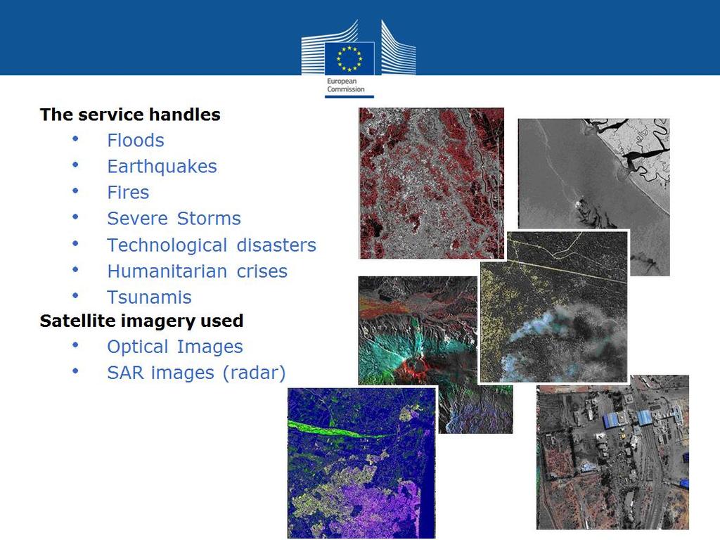
2 Copernicus is a European programme implemented by the European Commission. The services address six thematic areas: land, marine, atmosphere, climate change, emergency management and security. The Copernicus EMS Mapping service provides timely and accurate geospatial information derived from satellite remote sensing and completed by available in-situ data and open source information. 2
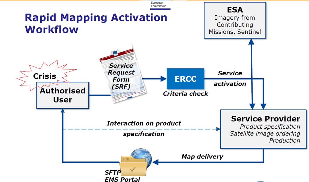
3 Who does what? Coordinated and paid by DG GROW (Internal Market, Industry, Entrepreneurship and SMEs) Technical support, contract management and quality assurance by the Joint Research Centre Operated by the Emergency Response Coordination Centre Service triggered by the Authorised Users Maps produced by the Service Provider Satellite images obtained by the European Satellite Agency 3
4
5
6
 Type 3: Reference + Delineation + Grading (damage grade and its spatial distribution) Maps are provided at two different scales: Toponyms and")
 and informal (slums, IDP camps, etc) Overview 1:25.000 1:50.000 1:100.000 1:200.000 1:500.000 Detail 1:5000 1:10.000 1:15.000 1:20.000 1:25.")
7 Reference Delineation Grading Base layer Hydrology: rivers, lakes, reservoirs and open water, etc Users can request 3 types of map products Type 1: Reference (with data prior to the disaster) Type 2: Reference + Delineation (assessment of the event extent) Type 3: Reference + Delineation + Grading (damage grade and its spatial distribution) Maps are provided at two different scales: Toponyms and administrative boundaries Physiography: cliffs, contours and spot heights, etc Land cover: cropland, grassland, scrub, forest, natural vegetation, bare soil, wetlands, etc Settlements, both formal (urban, suburban, rural, etc) and informal (slums, IDP camps, etc) Overview 1: : : : : Detail 1:5000 1: : : : Transport: all transport networks and related infrastructure (e.g. roads, tracks, trails, railways, bridges, harbours, and airfields) Industry and Utilities: industrial facilities and power stations
8 During an emergency, maps are provided within days or hours (in the so-called "rapid mapping"). For prevention and preparedness purposes, maps are provided within weeks or months (in the "risk and recovery mapping"). Both sorts of requests are channelled through the ERCC. The ERCC has a dual role: as an entry focal point and as an Authorised User in its own right. 8

9 Risk and recovery products On demand Standard base widely adaptable to user requests Weeks-months Reference maps Pre-disaster situation maps Reference maps Post-disaster situation maps Rapid mapping products On demand Standardized Hours-days Reference maps Disaster response maps 9
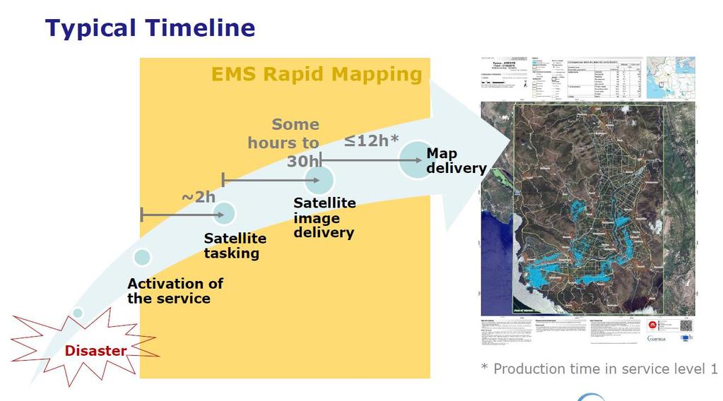
10 Rapid mapping products Map types and production mode Map type SL1* SL5** Production mode (service levels and delivery times) Reference map 9h 5 working days OR more (specify): Delineation map 12h 5 working days OR more (specify): Grading map 12h 5 working days OR more (specify): (*) is the fastest delivery (less than 1 day, times are map specific, see glossary at the end). For delineation and grading map a First Available Map is provided by default within 3h. (**) for activations which require delivery in some days, normally 5 working days. 10
11 Risk and recovery products MAP TYPE REFERENCE PRE - DISASTER POST - DISASTER CONTENT Detailed status of the territory and assets. e.g. topographic features and specific information, e.g. land use zoning plans, mitigation measures Relevant info to help planning for contingencies on vulnerable areas E.g. hazard exposure to hazardous events; vulnerability / resilience of settlements and buildings; risk status for population and assets; Evacuation plans; Forecasts; Alerts Relevant thematic information, beyond the immediate response phase E.g. hazard exposure to hazardous events; vulnerability / resilience of settlements and buildings; risk status for population and assets; post disaster needs assessment; recovery plans; reconstruction / rehabilitation monitoring; IDP monitoring (IDP camps, IDP movements). DELIV. TIME 30d(#) 30d(#) 30d(#) (#) calendar day after signature of a specific contract, which may require normally 30 days 11 after the service request
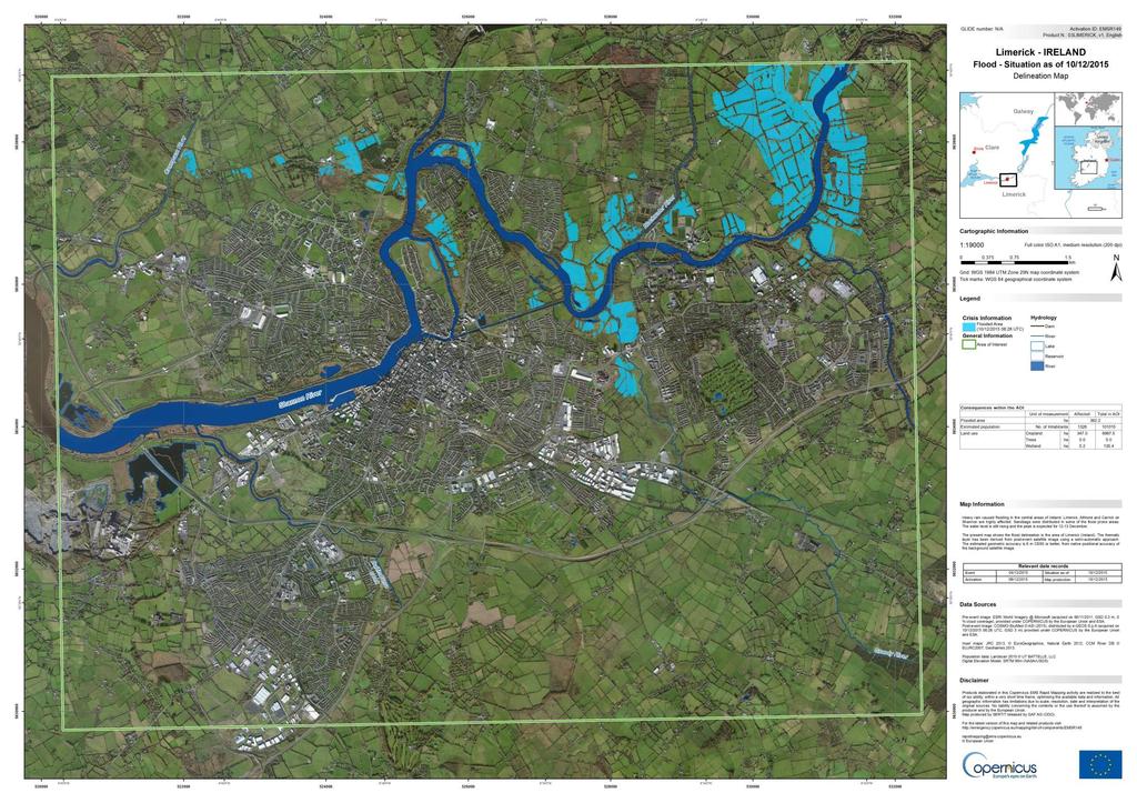
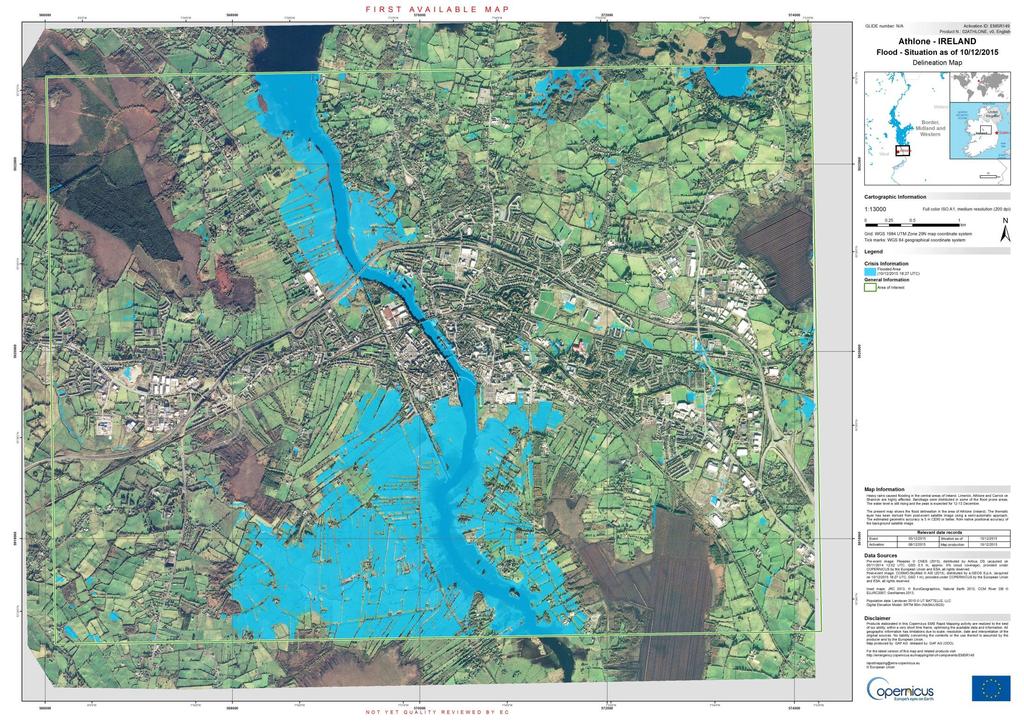
12 Delineation mapping Delineation maps provide an assessment of the event extent (and of its evolution if requested). Delineation maps are derived from satellite postdisaster images. They vary depending on the disaster type and the delineation of the areas impacted by the disaster. Used extensively for the severe weather of , detailing the extent of the flood. 12
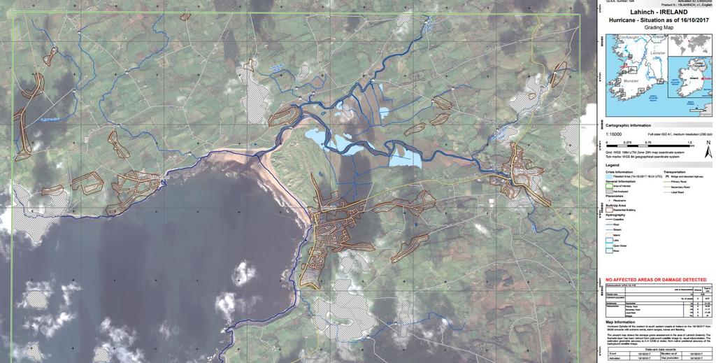
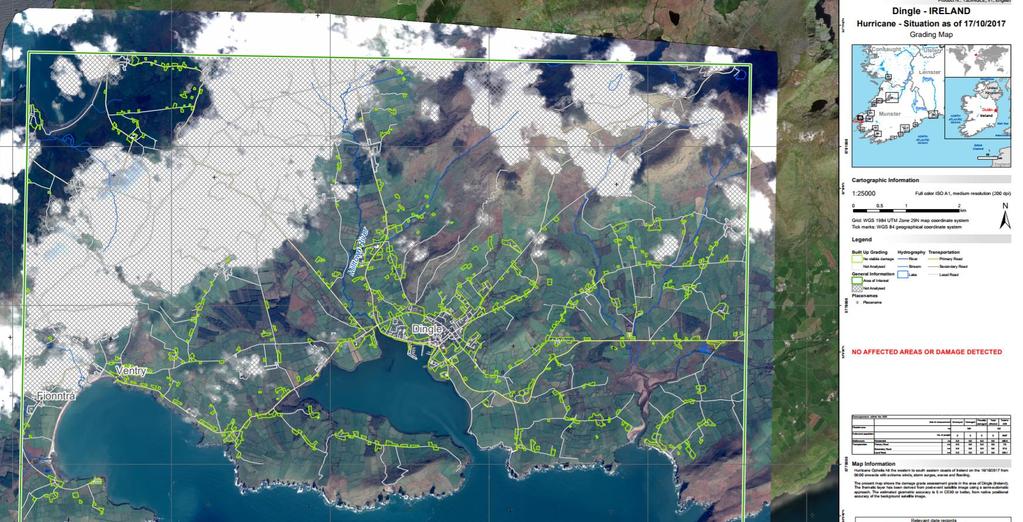
13 Grading Maps Grading maps provide an assessment of the damage grade (and of its evolution if requested). Grading maps are derived from post-event satellite images. Grading maps include the extent, magnitude or damage grades specific to each disaster type. They may also provide relevant and up-to-date information that is specific to affected population and assets, e.g. settlements, transport networks, industry and utilities. 13
14 Examples of Grading Maps Earthquake grading map with the count of the number of destroyed/ damaged buildings in each cell of a regular grid. Population, roads, hospitals, shelters, gathering areas, etc. may be included. 14
15 15
16 16
17 17
18 18
19 Future Copernicus working with the Department of Housing, Planning & Local Government s GIS team to develop a way of utilising ArcGIS online (AGOL) which is ESRI s collaborative web GIS, it allows users to create and share maps, data and applications. This collaboration will allow Copernicus maps to utilise the data from AGOL and develop all lawyers as deemed required by the emergency, quickly and easily. 19
20 THANK YOU FOR YOUR ATTENTION 20
Copernicus Overview and Emergency Management Service
 Copernicus Overview and Emergency Management Service Frédéric BASTIDE European Commission Open informal session of the United Nations Inter-Agency Meeting on Outer Space Activities 12 March 2013, Geneva
Copernicus EMS: Αξιολόγηση πολλαπλών φυσικών κινδύνων - Σχεδιασμός και Ανάκτηση
 Building Capacity for a Centre of Excellence for EO-based monitoring of Natural Disasters Copernicus EMS: Αξιολόγηση πολλαπλών φυσικών κινδύνων - Σχεδιασμός και Ανάκτηση Γιάννης Παπουτσής ΙΑΑΔΕΤ Εθνικό
EuroGEOSS Protected Areas Pilot
 EuroGEOSS Protected Areas Pilot Max Craglia European Commission Joint Research Centre Part 1: the present MyNatura2000 Mobile app. Awareness raising & volunteered data collection. Natura2000 covers 18%
L i n k i n g f l o o d i m p a c t f o r e c a s t i n g a n d s a t e l l i t e r a p i d m a p p i n g i n E u r o p e
 L i n k i n g f l o o d i m p a c t f o r e c a s t i n g a n d s a t e l l i t e r a p i d m a p p i n g i n E u r o p e Francesco Dottori, Milan Kalas, Peter Salamon, Annett Wania, Ines Rivero (EC JRC)
Emergency Management Service (EMS) mapping
 mapping") GMES Emergency Management Service (EMS) mapping Frédéric BASTIDE GMES unit, European Commission UN-SPIDER Expert Meeting: "Crowdsource Mapping for Disaster Risk Management and Emergency Response" 3-5 December,
GMES Emergency Management Service (EMS) mapping Frédéric BASTIDE GMES unit, European Commission UN-SPIDER Expert Meeting: "Crowdsource Mapping for Disaster Risk Management and Emergency Response" 3-5 December,
Copernicus Information & Training Session
 Copernicus Information & Training Session Copernicus Emergency Management Service Dora Aifantopoulou GEOAPIKONISIS S.A.P.GE. Copernicus EU Copernicus EU Copernicus EU www.copernicus.eu Athens 07.10.2016
Framework Contract for Copernicus Service in Support to EU External Action Geospatial Production
 Framework Contract for Copernicus Service in Support to EU External Action Geospatial Production ANNEX E to the Tender Specifications SEA Portfolio Invitation to tender SATCEN-OP-01/17 Page 1 of 11 1.
Global Monitoring for Environment and Security (GMES)
") Global Monitoring for Environment and Security (GMES) Satellite Earth Observation for the Emergency Services Dr Nick Veck Presentation to the G-STEP Launch Univ. of Leicester 19 th June 2009 Contents of
Global Monitoring for Environment and Security (GMES) Satellite Earth Observation for the Emergency Services Dr Nick Veck Presentation to the G-STEP Launch Univ. of Leicester 19 th June 2009 Contents of
The UN-GGIM: Europe core data initiative to encourage Geographic information supporting Sustainable Development Goals Dominique Laurent, France
 INSPIRE conference Strasbourg 6 September 2017 The UN-GGIM: Europe core data initiative to encourage Geographic information supporting Sustainable Development Goals Dominique Laurent, France Introduction
Norwegian spatial data infrastructure supporting disaster risk management Norwegian Mapping Authority
 Norwegian spatial data infrastructure supporting disaster risk management Norwegian Mapping Authority Arvid Lillethun, Norwegian Mapping Authority Land and Poverty 2018 Conference, World Bank 19.-23. March
Airbus DS Consortium Risk and Recovery. Airbus DS Corporate Presentation
 Airbus DS Consortium Risk and Recovery 1 January, 2017 Airbus DS Corporate Presentation 2 SERTIT s Copernicus EMS mapping service Risk & Recovery and Rapid Mapping Based on our 24/7/365 operational rapid
Georeferencing and Satellite Image Support: Lessons learned, Challenges and Opportunities
 Georeferencing and Satellite Image Support: Lessons learned, Challenges and Opportunities Shirish Ravan shirish.ravan@unoosa.org UN-SPIDER United Nations Office for Outer Space Affairs (UNOOSA) UN-SPIDER
SYNERGY OF SATELLITE REMOTE SENSING AND SENSOR NETWORKS ON GEO GRID
 SYNERGY OF SATELLITE REMOTE SENSING AND SENSOR NETWORKS ON GEO GRID National Institute of Advanced Industrial Science and Technology, Japan Yoshio Tanaka (on behalf of AIST GEO Grid team) Contents Brief
Two case history of EMS data application: earthquake in central italy and flooding in Piedmont region
 Two case history of EMS data application: earthquake in central italy and flooding in Piedmont region Luca Lanteri*, Rocco Pispico*, R. Cremonini** *Arpa Piemonte, Geological and Natural Risk Dipartiment
Uses of free satellite imagery for Disaster Risk Reduction (DRR)
") Centre of Applied Geoscience, Disaster Risk Reduction Research Group, School of Earth and Environmental Science, University of Portsmouth, UK Uses of free satellite imagery for Disaster Risk Reduction
Centre of Applied Geoscience, Disaster Risk Reduction Research Group, School of Earth and Environmental Science, University of Portsmouth, UK Uses of free satellite imagery for Disaster Risk Reduction
Table ronde 5 : Cartographie d'urgence Emergency Mapping.
 Table ronde 5 : Cartographie d'urgence Emergency Mapping MapAction is an international NGO that provides maps and other information services to help humanitarian relief organisations in the field MapAction
EMERGENCY. User Awareness & Training: Bucharest, Romania 8 th November 2013 Agata Priolo
 This presentation includes material courtesy of DG ENTR and DG JRC User Awareness & Training: EMERGENCY Bucharest, Romania 8 th November 2013 Agata Priolo Content Module 1: INTRODUCTION to GIO EMS Services
International Conference Analysis and Management of Changing Risks for Natural Hazards November 2014 l Padua, Italy
 Abstract Code: B01 Assets mapping products in support of preparedness and prevention measures (examples from Germany, Italy and France) Marc Mueller, Thierry Fourty, Mehdi Lefeuvre Airbus Defence and Space,
Use of Geospatial data for disaster managements
 Use of Geospatial data for disaster managements Source: http://alertsystemsgroup.com Instructor : Professor Dr. Yuji Murayama Teaching Assistant : Manjula Ranagalage What is GIS? A powerful set of tools
Effective Utilization of Synthetic Aperture Radar (SAR) Imagery in Rapid Damage Assessment
 Imagery in Rapid Damage Assessment") Effective Utilization of Synthetic Aperture Radar (SAR) Imagery in Rapid Damage Assessment Case Study Pakistan Floods SUPARCO M. Maisam Raza, Ahmad H. Rabbani SEQUENCE Flood Monitoring using Satellite
Effective Utilization of Synthetic Aperture Radar (SAR) Imagery in Rapid Damage Assessment Case Study Pakistan Floods SUPARCO M. Maisam Raza, Ahmad H. Rabbani SEQUENCE Flood Monitoring using Satellite
Roles of NGII in successful disaster management
 The Second UN-GGIM-AP Plenary Meeting Roles of NGII in successful disaster management Republic of Korea Teheran Iran 28 October 2013 Sanghoon Lee, Ph.D. NGII Outline Type of Disasters Occur in Korea Practical
SUPPORTS SUSTAINABLE GROWTH
 DDSS BBUUN NDDLLEE G E O S P AT I A L G O V E R N A N C E P A C K A G E SUPPORTS SUSTAINABLE GROWTH www.digitalglobe.com BRISBANE, AUSTRALIA WORLDVIEW-3 30 CM International Civil Government Programs US
Disaster RISK Management : Bhutanese Scenario
 Disaster RISK Management : Bhutanese Scenario Expert Group Meeting (EGM) on Geo-referenced Information Systems for Disaster Risk Management (Geo-DRM) and sustaining the Community of Practice (COP), Bangkok,
Crisis Management and Natural Disasters Overview of JRC operational or pre-operational activities A. Annunziato, D. Al-Khudhairy
 Papagayo, Costarica 3-4 November 2009 Security Science and The Americas 1 Joint Research Centre (JRC) Crisis Management and Natural Disasters Overview of JRC operational or pre-operational activities A.
GIS in Weather and Society
 GIS in Weather and Society Olga Wilhelmi Institute for the Study of Society and Environment National Center for Atmospheric Research WAS*IS November 8, 2005 Boulder, Colorado Presentation Outline GIS basic
Introduction. Thematic Mapping for Disaster Risk Assessment in Case of Earthquake FIG Working Week
 Thematic Mapping for Disaster Risk Assessment in Case of Earthquake Silvia MARINOVA, Temenoujka BANDROVA, Mihaela KOUTEVA-GUENTCHEVA, Stefan BONCHEV University of Architecture, Civil Engineering and Geodesy
C o p e r n i c u s E M S i n s u p p o r t o f c r i s i s p r e p a r e d n e s s a n d r e s p o n s e o p e r a t i o n s
 C o p e r n i c u s E M S i n s u p p o r t o f c r i s i s p r e p a r e d n e s s a n d r e s p o n s e o p e r a t i o n s Copernicus Service Copernicus EU Copernicus EU Copernicus EU www.copernicus.eu
GIS and Remote Sensing Support for Evacuation Analysis
 GIS and Remote Sensing Support for Evacuation Analysis Presented to GIS for Transportation Symposium Rapid City, South Dakota March 28-31, 2004 Demin Xiong Oak Ridge National Laboratory 2360 Cherahala
Green Space Services for Local Monitoring
 Green Space Services for Local Monitoring Aratos Group V3.0 2016/08 Value added services for the society using space and satellite technologies Aratos Group 2 One of the first European downstream value
Copernicus Emergency Management Service - Mapping Manual of Operational Procedures
 333333 Copernicus Emergency Management Service - Mapping Manual of Operational Procedures Guidelines for EC Services, Service Providers and Authorised Users Document prepared by the European Commission
I&CLC2000 in support to new policy initiatives (INSPIRE, GMES,..)
") I&CLC2000 in support to new policy initiatives (INSPIRE, GMES,..) Manfred Grasserbauer, Director Joint Research Centre Institute for Environment and Sustainability 1 IMAGE 2000 European mosaic of satellite
I&CLC2000 in support to new policy initiatives (INSPIRE, GMES,..) Manfred Grasserbauer, Director Joint Research Centre Institute for Environment and Sustainability 1 IMAGE 2000 European mosaic of satellite
Understanding Weather and Climate Risk. Matthew Perry Sharing an Uncertain World Conference The Geological Society, 13 July 2017
 Understanding Weather and Climate Risk Matthew Perry Sharing an Uncertain World Conference The Geological Society, 13 July 2017 What is risk in a weather and climate context? Hazard: something with the
European Drought Observatory Progress on Drought Monitoring
 European Drought Observatory Progress on Drought Monitoring Alfred de Jager Diego Magni European Commission Joint Research Centre (JRC) Disaster Risk Management Unit Outline 1. Introduction Philosophy
Applying Hazard Maps to Urban Planning
 Applying Hazard Maps to Urban Planning September 10th, 2014 SAKAI Yuko Disaster Management Expert JICA Study Team for the Metro Cebu Roadmap Study on the Sustainable Urban Development 1 Contents 1. Outline
THE STUDY ON 4S TECHNOLOGY IN THE COMMAND OF EARTHQUAKE DISASTER EMERGENCY 1
 THE STUDY ON 4S TECHNOLOGY IN THE COMMAND OF EARTHQUAKE DISASTER EMERGENCY 1 Zhou Wensheng 1, Huang Jianxi 2, Li Qiang 3, Liu Ze 3 1 Associate Professor, School of Architecture, Tsinghua University, Beijing.
ENV208/ENV508 Applied GIS. Week 1: What is GIS?
 ENV208/ENV508 Applied GIS Week 1: What is GIS? 1 WHAT IS GIS? A GIS integrates hardware, software, and data for capturing, managing, analyzing, and displaying all forms of geographically referenced information.
Hurricane Readiness for Coastal Communities
 Hurricane Readiness for Participant Guide Developed for: Federal Emergency Management Agency Emergency Management Institute 16825 South Seton Avenue Emmitsburg, MD 21727-8998 Developed by: C² Technologies,
DEVELOPMENT OF A FORECAST EARLY WARNING SYSTEM ethekwini Municipality, Durban, RSA. Clint Chrystal, Natasha Ramdass, Mlondi Hlongwae
 DEVELOPMENT OF A FORECAST EARLY WARNING SYSTEM ethekwini Municipality, Durban, RSA Clint Chrystal, Natasha Ramdass, Mlondi Hlongwae LOCATION DETAILS AND BOUNDARIES ethekwini Municipal Area = 2297 km 2
Disaster Management in Republic of Korea
 The Third UN-GGIM-AP Plenary Meeting Disaster Management in Republic of Korea ~Coordination among NGIA & Other Related Organizations and Recommendations~ Bali Indonesia 10 November 2014 Sanghoon Lee, Ph.D.
GMES Service for Geospatial Reference Data Access (RDA) Covering Areas Outside Europe
 Covering Areas Outside Europe") INSPIRE Conference 2011 Edinburgh 27 June - 1 July GMES Service for Geospatial Reference Data Access (RDA) Covering Areas Outside Europe Andrea Ajmar, Simone Balbo, Piero Boccardo, Simone Dalmasso, Anna
INSPIRE Conference 2011 Edinburgh 27 June - 1 July GMES Service for Geospatial Reference Data Access (RDA) Covering Areas Outside Europe Andrea Ajmar, Simone Balbo, Piero Boccardo, Simone Dalmasso, Anna
CENSUS MAPPING WITH GIS IN NAMIBIA. BY Mrs. Ottilie Mwazi Central Bureau of Statistics Tel: October 2007
 CENSUS MAPPING WITH GIS IN NAMIBIA BY Mrs. Ottilie Mwazi Central Bureau of Statistics E-mail: omwazi@npc.gov.na Tel: + 264 61 283 4060 October 2007 Content of Presentation HISTORICAL BACKGROUND OF CENSUS
United States Multi-Hazard Early Warning System
 United States Multi-Hazard Early Warning System Saving Lives Through Partnership Lynn Maximuk National Weather Service Director, Central Region Kansas City, Missouri America s s Weather Enterprise: Protecting
Summary of Available Datasets that are Relevant to Flood Risk Characterization
 Inter-Agency Characterization Workshop February 25-27, 2014 USACE Institute for Water Resources, Alexandria, VA, IWR Classroom Summary of Available Datasets that are Relevant to Characterization National
Status and Challenges on Geo-DRM Information Systems in Tonga
 Name: Mafua- i-vai utukakau Maka Status and Challenges on Geo-DRM Information Systems in Tonga 1 Roles and Relationships Land and Geographic Information Systems (LGIS) Unit: Establish updated high-resolution
GIS and Remote Sensing
 Spring School Land use and the vulnerability of socio-ecosystems to climate change: remote sensing and modelling techniques GIS and Remote Sensing Katerina Tzavella Project Researcher PhD candidate Technology
Spatial Analysis of Natural Hazard and Climate Change Risks in Peri-Urban Expansion Areas of Dakar, Senegal
 1 Spatial Analysis of Natural Hazard and Climate Change Risks in Peri-Urban Expansion Areas of Dakar, Senegal URBAN WEEK 2009 BBL Preston Lounge Thursday, March 12, 2009 Christian Hoffmann GeoVille group
LandScan Global Population Database
 LandScan Global Population Database The World s Finest Population Distribution Data Uncommon information. Extraordinary places. LandScan Global Population Database East View Cartographic is now offering
Land Accounts - The Canadian Experience
 Land Accounts - The Canadian Experience Development of a Geospatial database to measure the effect of human activity on the environment Who is doing Land Accounts Statistics Canada (national) Component
IMPLEMENTING GOVERNMENT-WIDE ENTERPRISE GIS; THE FEDERATED MODEL
 IMPLEMENTING GOVERNMENT-WIDE ENTERPRISE GIS; THE FEDERATED MODEL James E. Mitchell, Ph. D. IT GIS Manager Louisiana Department of Transportation and Development presented at the ESRI International Users
GIS as a tool in flood management
 GIS for the United Nations and the International Community Conference Panel: GIS and Capacity - How Territorial Planning Benefits from Geospatial Information 3-5 April 2012 Geneva, Switzerland GIS as a
The AIR Bushfire Model for Australia
 The AIR Bushfire Model for Australia In February 2009, amid tripledigit temperatures and drought conditions, fires broke out just north of Melbourne, Australia. Propelled by high winds, as many as 400
Applied Geoscience and Technology Division SOPAC. Joy Papao, Risk Information Systems Officer
 Joy Papao, Risk Information Systems Officer Secretariat of the Pacific Community SPC 22 Pacific Island States Head office in Noumea, New Caledonia 2 Regional offices (Pohnpei and Honiara) 600 staff 9 Technical
Overview and purposes of the meeting
 Overview and purposes of the meeting 1 Flash Floods vs. River Floods Riverine Flooding: is caused by heavy rainfall (and/or snow melt) over long periods e.g., days, leading to rising water levels and flooding
Compact guides GISCO. Geographic information system of the Commission
 Compact guides GISCO Geographic information system of the Commission What is GISCO? GISCO, the Geographic Information System of the COmmission, is a permanent service of Eurostat that fulfils the requirements
Emerging Needs, Challenges and Response Strategy
 Emerging Needs, Challenges and Response Strategy Development of Integrated Observing Systems in China JIAO Meiyan Deputy Administrator China Meteorological Administration September 2011 Geneva Outline
Advanced Image Analysis in Disaster Response
 Advanced Image Analysis in Disaster Response Creating Geographic Knowledge Thomas Harris ITT The information contained in this document pertains to software products and services that are subject to the
Geo-information and Disaster Risk Reduction in the Hindu Kush-Himalayan region
 Geo-information and Disaster Risk Reduction in the Hindu Kush-Himalayan region Basanta Shrestha, Division Head MENRIS, International Centre for Integrated Mountain Development Kathmandu, Nepal The International
Using Operating Experience to Prevent or Mitigate Nuclear Events. What Is, Was and Will Be Available
 Using Operating Experience to Prevent or Mitigate Nuclear Events What Is, Was and Will Be Available Introduction Remember, it is by understanding the lessons learned from past events that we can adequately
NGIAs' roles in successful disaster response
 The Second UN-GGIM-AP Plenary Meeting NGIAs' roles in successful disaster response Japan Teheran Iran 28 October 2013 Shin-ichi SAKABE, Director of International Affairs Division Geospatial Information
The World Bank Ecuador Risk Mitigation and Emergency Recovery Project (P157324)
") Public Disclosure Authorized LATIN AMERICA AND CARIBBEAN Ecuador Social, Urban, Rural and Resilience Global Practice Global Practice IBRD/IDA Investment Project Financing FY 2016 Seq No: 2 ARCHIVED on
Public Disclosure Authorized LATIN AMERICA AND CARIBBEAN Ecuador Social, Urban, Rural and Resilience Global Practice Global Practice IBRD/IDA Investment Project Financing FY 2016 Seq No: 2 ARCHIVED on
sentinel-2 COLOUR VISION FOR COPERNICUS
 sentinel-2 COLOUR VISION FOR COPERNICUS SATELLITES TO SERVE By providing a set of key information services for a wide range of practical applications, Europe s Copernicus programme is providing a step
European Topic Centre on Land Urban and Soil Systems. Green Infrastructure at EEA
 Green Infrastructure at EEA A SPATIAL APPROACH TO MAPPING GI Stefan Kleeschulte, ETC ULS GI and territorial cohesion 2011 first EEA report on Green Infrastructure Underlining the need to develop tools
NATIONAL FRAMEWORK FOR FLOOD DISASTER MANAGEMENT IN INDONESIA. 11 th GEOSS ASIA PASIFIC SYMPOSIUM Kyoto, October 2018
 NATIONAL FRAMEWORK FOR FLOOD DISASTER MANAGEMENT IN INDONESIA 11 th GEOSS ASIA PASIFIC SYMPOSIUM Kyoto, 24-26 October 2018 1 OUTLINE Disasters in Indonesia The Disaster Management Mechanism Current Status
The known requirements for Arctic climate services
 The known requirements for Arctic climate services based on findings described in STT White paper 8/2015 Johanna Ekman / EC PHORS STT Regional drivers The Arctic region is home to almost four million people
Geospatial Technologies for Resources Planning & Management
 Geospatial Technologies for Resources Planning & Management Lal Samarakoon, PhD Director, Geoinformatics Center Asian Institute of Technology, Thailand Content Geoinformatics for SDG Information Integration
Flood Level Simulation Modeling And Vulnerability Of Slums Along Musiriver, Hyderabad
 International Journal of Humanities and Social Science Invention (IJHSSI) ISSN (Online): 2319 7722, ISSN (Print): 2319 7714 Volume 7 Issue 05 Ver. I May. 2018 PP.51-56 Flood Level Simulation Modeling And
Geodesy. orientation. shape. gravity field
 Geodesy noun Science of measuring the shape, orientation and gravity field of the Earth and how it changes over time. shape orientation gravity field Positioning has always been important Downstream applications
Emerging issues to use geospatial initiatives in the societal context of disaster managing **
 ADVANCE UNEDITED VERSION UNITED NATIONS E/CONF.103/3/Add.1 ECONOMIC AND SOCIAL COUNCIL Tenth United Nations Regional Cartographic Conference for the Americas New York, 19-23, August 2013 Item 6 (a) of
USING 3D GIS TO ASSESS ENVIRONMENTAL FLOOD HAZARDS IN MINA
 King Fahd University of Petroleum & Minerals College of Environmental Design Geographical Information system USING 3D GIS TO ASSESS ENVIRONMENTAL FLOOD HAZARDS IN MINA Prepared by : Ali AL-Zahrani OUTLINE
Fort Lauderdale s GIS Supports Response to. Hurricane Irma
 Fort Lauderdale s GIS Supports Response to Hurricane Irma By Monica Pratt, ArcUser Editor When Hurricane Irma first made landfall in the Florida Keys on September 10, 2017, it brought destructive 70 mph
Report of the Working Group 2 Data Sharing and Integration for Disaster Management *
 UNITED NATIONS E/CONF.104/6 ECONOMIC AND SOCIAL COUNCIL Twentieth United Nations Regional Cartographic Conference for Asia and the Pacific Jeju, 6-9 October 2015 Item 5 of the provisional agenda Report
DIPLOMA IN DISASTER MANAGEMENT. (Non-Semester) (With effect from the academic year )
 (With effect from the academic year )") DIPLOMA IN DISASTER MANAGEMENT (Non-Semester) (With effect from the academic year 2013-14) Eligibility for the Course Candidate should have passed the Higher Secondary Examination conducted by the Board
DIPLOMA IN DISASTER MANAGEMENT (Non-Semester) (With effect from the academic year 2013-14) Eligibility for the Course Candidate should have passed the Higher Secondary Examination conducted by the Board
Spanish national plan for land observation: new collaborative production system in Europe
 ADVANCE UNEDITED VERSION UNITED NATIONS E/CONF.103/5/Add.1 Economic and Social Affairs 9 July 2013 Tenth United Nations Regional Cartographic Conference for the Americas New York, 19-23, August 2013 Item
Role of GIS and Remote Sensing to Environment Statistics
 United Nations Economic Commission for Africa Role of GIS and Remote Sensing to Environment Dozie Ezigbalike Data Management Coordinator A Definition Environment statistics are statistics that describe
Sentinel Asia Tsunami Working Group
 Sentinel Asia Tsunami Working Group Co-Chairman: Prof. Shunichi Koshimura Abdul Muhari, PhD 4 th Joint Project Team Meeting (JPTM 2017): Sentinel Asia STEP 3 Abdul MUHARI, PhD Ministry of Marine Affairs
GI Technology for Disaster Management
 GI Technology for Disaster Management 17 th ICC on the Regional Space Applications Programme for Sustainable Development (RESAP) 26 th Nov 2013 Bangkok Thailand Period and time of seasonal in thailand
World Meteorological Organization
 World Meteorological Organization Opportunities and Challenges for Development of Weather-based Insurance and Derivatives Markets in Developing Countries By Maryam Golnaraghi, Ph.D. Head of WMO Disaster
CAN THO URBAN DEVELOPMENT AND RESILIENCE PROJECT
 CAN THO URBAN DEVELOPMENT AND RESILIENCE PROJECT 1 Phnom Penh Can Tho City HCM City EAST SEA 2 1 3 Highest Water Level WATER LEVEL RAISE IN CAN THO DURING LAST 40 YEARS 4 2 Land subsidence a threat that
Jim Fox. copyright UNC Asheville's NEMAC
 Decisions and System Thinking Jim Fox November, 2012 1 UNC Asheville s s NEMAC National Environmental Modeling and Analysis Center Applied Research and technology development on integration of environmental
KENTUCKY HAZARD MITIGATION PLAN RISK ASSESSMENT
 KENTUCKY HAZARD MITIGATION PLAN RISK ASSESSMENT Presentation Outline Development of the 2013 State Hazard Mitigation Plan Risk Assessment Determining risk assessment scale Census Data Aggregation Levels
Regional Flash Flood Guidance and Early Warning System
 WMO Training for Trainers Workshop on Integrated approach to flash flood and flood risk management 24-28 October 2010 Kathmandu, Nepal Regional Flash Flood Guidance and Early Warning System Dr. W. E. Grabs
Space Applications for Disaster Risk Reduction and Sustainable Development
 Space Applications for Disaster Risk Reduction and Sustainable Development Space Applications Section (SAS) ICT and Disaster Risk Reduction Division (IDD) UNESCAP Contents I. RESAP Activities 2016-2017
User Awareness & Training Event: Parallel 3c EMERGENCY (Room 1) Bucharest, Romania 7 th November 2013 A.Priolo, D.Grandoni
 Bucharest, Romania 7 th November 2013 A.Priolo, D.Grandoni") User Awareness & Training Event: Parallel 3c EMERGENCY (Room 1) Bucharest, Romania 7 th November 2013 A.Priolo, D.Grandoni Content Demo and Training Module 2: Live Demonstration: GIO Emergency services
User Awareness & Training Event: Parallel 3c EMERGENCY (Room 1) Bucharest, Romania 7 th November 2013 A.Priolo, D.Grandoni Content Demo and Training Module 2: Live Demonstration: GIO Emergency services
NOAA s Regional Climate Science & Information: Opportunities and Challenges
 NOAA s Regional Climate Science & Information: Opportunities and Challenges Dr. Wayne Higgins Climate Program Office, Director Office of Oceanic and Atmospheric Research National Oceanic and Atmospheric
ENSURE. Coordinator: Hormoz MODARESSI Website:
 ENSURE Coordinator: Hormoz MODARESSI h.modaressi@brgm.fr Website: http://ensureproject.eu/ The project is financed by the European Commission under the 7th Framework Programme for Research and Technological
Status & Challengers of Cook Islands GEO DRM. Cook Islands GEO S/GIS History
 Status & Challengers of Cook Islands GEO DRM By Patrick A. ARIOKA Planning & Advisory Officer EMERGENCY MANAGEMENT COOK ISLANDS Cook Islands GEO S/GIS History 1990 NZODA/MFAT trained by Landcare Research
Applications of GIS in Electrical Power System. Dr. Baqer AL-Ramadan Abdulrahman Al-Sakkaf
 Applications of GIS in Electrical Power System Dr. Baqer AL-Ramadan Abdulrahman Al-Sakkaf OUTLINES: Objective Importance of GIS GIS data development Application of GIS Findings Conclusions and Recommendations
USGS Hydrography Overview. May 9, 2018
 + 1 USGS Hydrography Overview May 9, 2018 + 2 The National Geospatial Program Provides the geospatial baseline of the Nation s topography, natural landscape and built environment through The National Map,
Introduction to GIS. Dr. M.S. Ganesh Prasad
 Introduction to GIS Dr. M.S. Ganesh Prasad Department of Civil Engineering The National Institute of Engineering, MYSORE ganeshprasad.nie@gmail.com 9449153758 Geographic Information System (GIS) Information
The U.S. National Integrated Drought Information System. Roger S. Pulwarty National Oceanic and Atmospheric Administration USA
 The U.S. National Integrated Drought Information System Roger S. Pulwarty National Oceanic and Atmospheric Administration USA Drought: Weather-climate continuum and adaptation deficits 2010 2011 2012 2015
Regional EGM on Community of Practice of Georeferenced Information System. for Disaster Risk Management (Geo-DRM) April 2014, Bangkok, Thailand
 April 2014, Bangkok, Thailand") Regional EGM on Community of Practice of Georeferenced Information System for Disaster Risk Management (Geo-DRM) 23-25 April 2014, Bangkok, Thailand Presented By Mukesh Kumar Keshari Ministry of Home Affairs
Regional EGM on Community of Practice of Georeferenced Information System for Disaster Risk Management (Geo-DRM) 23-25 April 2014, Bangkok, Thailand Presented By Mukesh Kumar Keshari Ministry of Home Affairs
Mapping Water Resources and Reservoirs for Climate Resilience in Zambezi River Basin
 Mapping Water Resources and Reservoirs for Climate Resilience in Zambezi River Basin Corné van der Sande, NEO BV Senior Advisor Earth Observation Services for Monitoring Drought and Water Resources in
Greg Collier, Battalion Chief Larry Fox, Captain Mount Laurel Fire Department
 Greg Collier, Battalion Chief Larry Fox, Captain Mount Laurel Fire Department Hurdles (NAVTEQ data Laurel Green example) Current software use map books field data (COP, OEM, disasters, critical infrastructure,
USE OF GEOREFERENCE INFORMATION FOR DRM Arnob Bormdoi Research Associate, GIC
 USE OF GEOREFERENCE INFORMATION FOR DRM Arnob Bormdoi Research Associate, GIC CONTENTS INTRODUCTION THE IMPORTANCE OF SPATIAL INFORMATION CASE STUDIES SUMMARY INTRODUCTION The process of defining how raster
From Climate Science to Climate Services
 Making sense of complexity in an interdependent world: February 2013 From Climate Science to Climate Services Julia Slingo, Met Office Chief Scientist Climate Change: Taking the planet into uncharted territory?
Humanitarian Assistance and Disaster Relief (HADR)
") Humanitarian Assistance and Disaster Relief (HADR) Remote sensing, GIS & Server Technology for Planning, Response & Mitigation Jonathan Lee Hon Yip Senior Technical Sales, Intergraph Security, Government
Humanitarian Assistance and Disaster Relief (HADR) Remote sensing, GIS & Server Technology for Planning, Response & Mitigation Jonathan Lee Hon Yip Senior Technical Sales, Intergraph Security, Government
Plan4all (econtentplus project)
") Plan4all (econtentplus project) Karel CHARVAT 1, Tomáš MILDORF 2 1 Help service remote sensing, Ltd., Černoleská 1600, 256 01 Benešov u Prahy, Czech Republic charvat@bnhelp.cz 2 Department of Mathematics
Plan4all (econtentplus project) Karel CHARVAT 1, Tomáš MILDORF 2 1 Help service remote sensing, Ltd., Černoleská 1600, 256 01 Benešov u Prahy, Czech Republic charvat@bnhelp.cz 2 Department of Mathematics
The Third UN-GGIM-AP Plenary Meeting. Use of Geospatial Information in Disaster and Coordination among NDMA and Relevant Organizations/Stakeholders
 The Third UN-GGIM-AP Plenary Meeting Use of Geospatial Information in Disaster and Coordination among NDMA and Relevant Organizations/Stakeholders Bali Indonesia 10 November 2014 Bernardus Wisnu Widjaja
President s Day Weekend Storm Community Meeting and Workshop April 17, 2017
 President s Day Weekend Storm Community Meeting and Workshop April 17, 2017 Meeting outline 1. Progress update on the City of San Jose s recovery efforts 2. Water district presentation on: Weather situation