KENTUCKY HAZARD MITIGATION PLAN RISK ASSESSMENT
|
|
|
- Shavonne Owens
- 5 years ago
- Views:
Transcription


1 KENTUCKY HAZARD MITIGATION PLAN RISK ASSESSMENT
2 Presentation Outline Development of the 2013 State Hazard Mitigation Plan Risk Assessment Determining risk assessment scale Census Data Aggregation Levels State Wide Grid Dasymetric Mapping Risk Assessment Methodology Exposure Hazard Vulnerability How can your community use the plan maps Exposure Maps Hazard Maps Vulnerability Maps
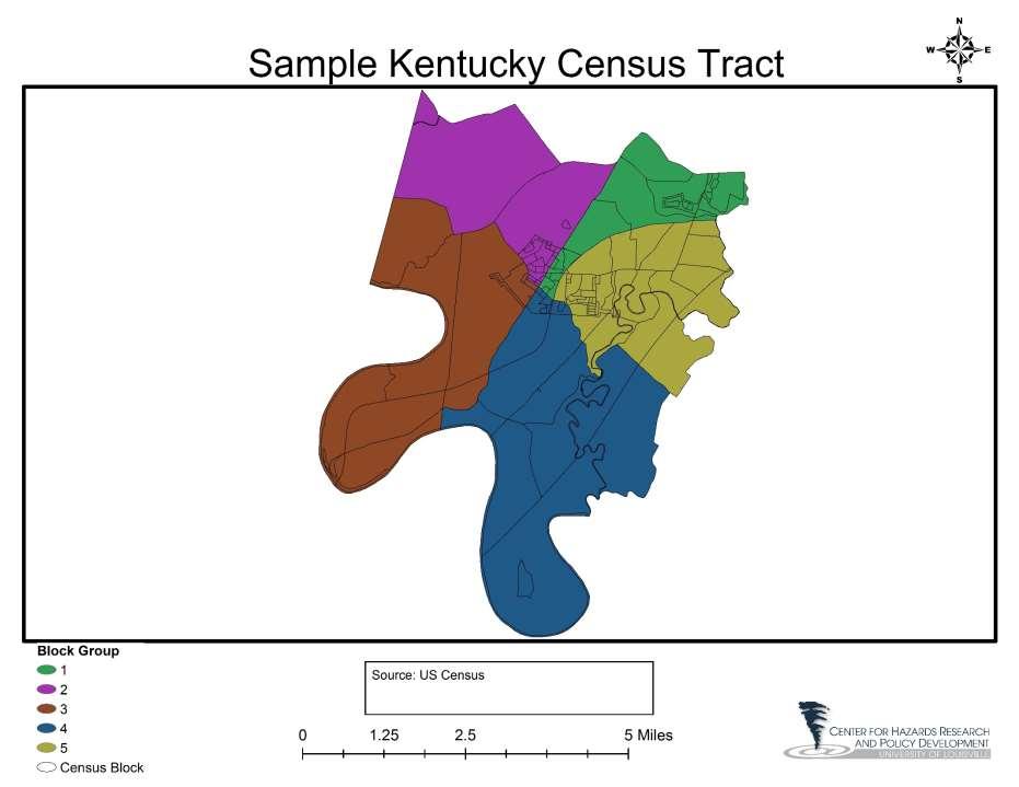
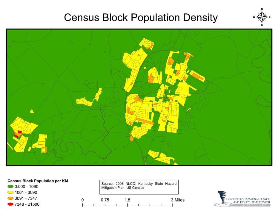
3 Census Data Aggregation Levels Aggregation Levels Country State County Tract Block Group Block Tracts, Block Groups, and Blocks are aggregation levels that are designed to be similar in population but not area.
4 Census Tracts Census Tracts are a statistical subdivision of a county Tracts are designed to have between 1,500 and 8,000 persons Tracts can change from Census to Census as the population changes. In Kentucky Counties have between 1 tract and 191 tracts in the 2010 Census
5 Census Block Groups Census Block Groups are a statistical subdivision of Census Tracts Block Groups are designed to have between 600 and 3,000 people with an optimum size of 1,500 Block Groups can change from Census to Census Block Groups are the smallest level which the Census bureau publishes sample data (American Communities Survey or ACS) As of the 2010 Census all data excluding population count, sex, age, race, or ownership status is sample data.
6 Census Blocks Census Blocks are a statistical subdivision of Block Groups Blocks in urban areas are often literally a city block, in rural areas blocks can be much larger In KY Blocks range from to less than.001 square kilometers. Blocks are the smallest subdivision that the Census releases full count data on.
7
8
9
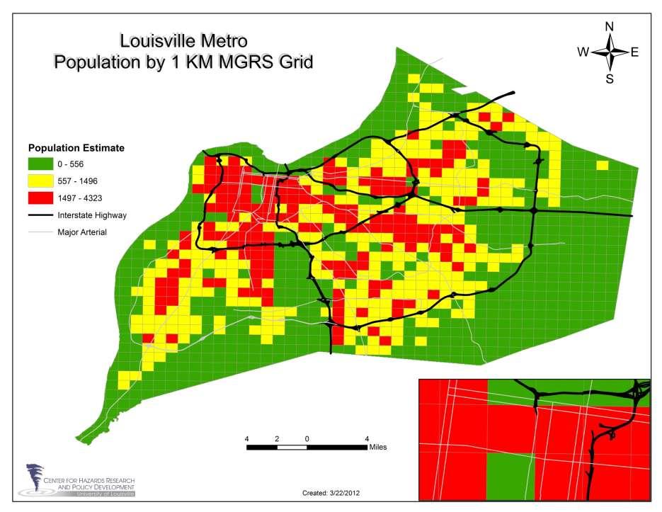
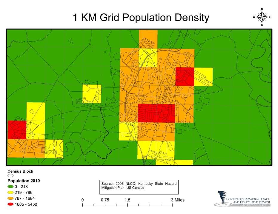
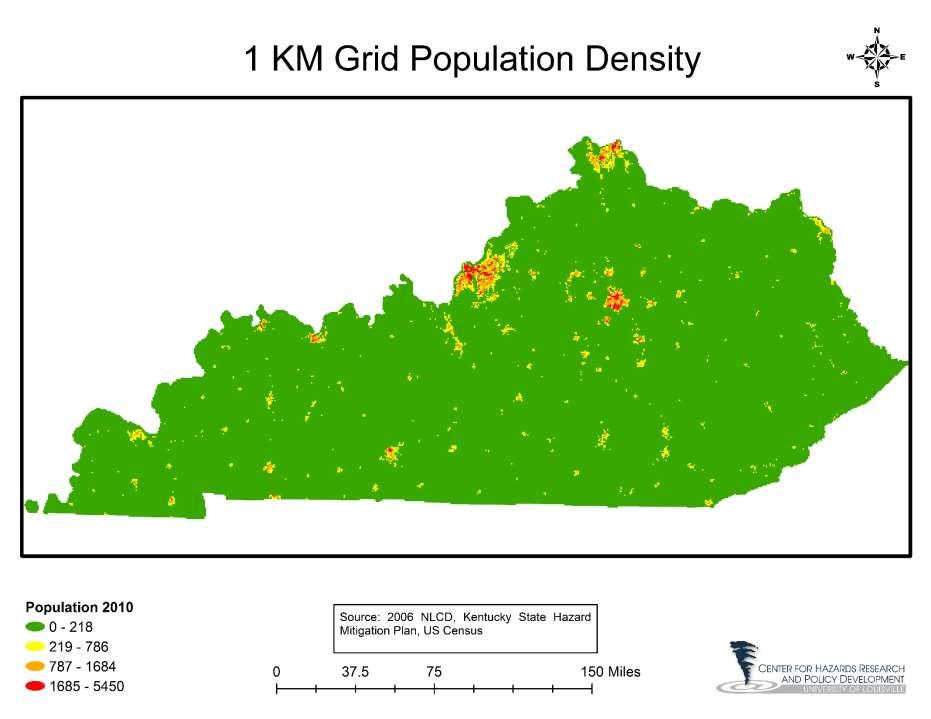
10 Military Grid Reference System MGRS provides an alternative aggregation level to the Census Block level Each unit is identical in size Allows better comparisons between units in different parts of the state Population and demographic data is not calculated at MGRS level Assign proportionally based on area Assign using Dasymetric mapping based on area
11 Grid Advantages For Risk Mapping Equal area calculations based on each unit being equal sized Allows better comparisons between planning areas in different parts of the State Potential for better policy decisions and dollar allocation Improved visual interpretations Enhanced tools for local planning usage Military grid provides enhanced usage during response and recovery
12
. http://pubs.usgs.gov/fs/2008/3010/fs2008-3010.")
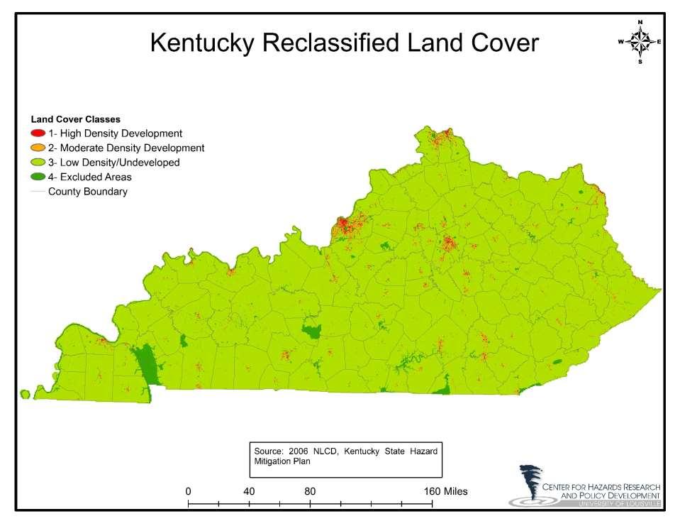
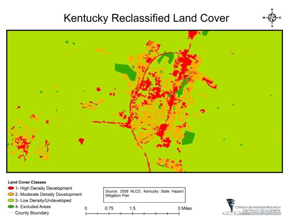
13 Dasymetric Mapping Method of mapping population within an aggregation area using population data and land cover data Plan used the urban 3 class method (shown in right most picture).
14 USGS Dasymetric Mapping Tool A free tool which simplifies the Dasymetric process Requires Land Cover data to be broken down into 4 Classes User defined breaks Suggests High Density Low Density Non-Urban Inhabited Uninhabited
15 USGS Dasymetric Tool Key functions Empirical Sampling Empirical sampling is used to determine the fraction of the census unit's population that should be allocated to each inhabited class for the study area Areal Weighting The population density fraction must be adjusted by the percentage of the block-group s total area that each inhabited class occupies. A ratio is calculated for each inhabited class representing the percentage of area that an inhabited class actually occupies within a block group to the expected percentage. The area ratio is used to adjust the population density fraction accounting for the variation of both the population density and area for the different inhabited classes for each block group. Source:
16
17
18 Land Cover Data Issues Low Resolution In non urban areas, there may not be a differentiation in land class between a residence and the surroundings Resolution is typically able to differentiate roads from surroundings in rural areas Assumption is population typically lives near roads Developed Areas that are uninhabited can show as high density development Use Feature Classes to reclassify raster areas to eliminate developed areas that are uninhabited Highways Airports Parks Block level data often finite enough that industrial areas are separated from residential areas and show no population
19
20
21
22
23
24
25
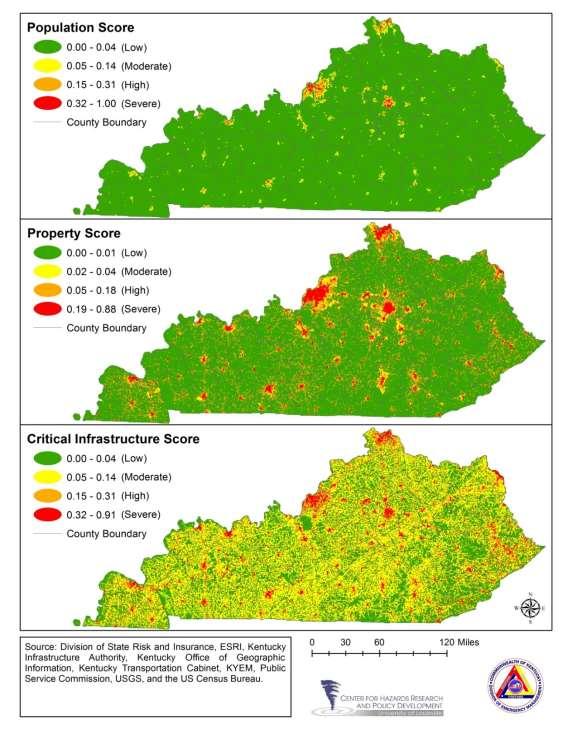
26 2013 Kentucky Risk Assessment Important definitions associated with this vulnerability assessment model: Exposure: A community s assets: people, property, essential facilities, and infrastructure potentially exposed to a hazard Hazard: Anything which either threatens the residents of a community or the things that they value Vulnerability: What part of an exposure is at risk to each hazard
27 Risk Model Simplified Hazard Vulnerability Score = Exposure Score + Hazard Score Exposure Score = Population Score + Property Score + Critical Infrastructure Score Hazard Score can generally be expressed as: Hazard Score= % Area Affected Score + Loss Score
28 General Scoring Methodology Data Aggregated to the Grid level Spatial point and line data that is not smoothed over an area is transformed using the Natural Log +1 (LN+1). This was done to reduce the effect of outliers on the overall score while maintaining its place in the order. Then Data scored from 0-1 to provide the variables score. Image from:
29 Exposure Made up of 3 categories each accounts for 1/3 of the score Population Score Property Score Critical Infrastructure Score
30 Population Score Population Score is comprised of one variable 2010 Census block population Assigned using Dasymetric mapping Used 2010 Census Data 2006 Land Cover Data
31
32 Property Score Property Score is comprised of two variables 2010 Census Block Group Total Household value Each Grid was assigned household value based on that grids percent area of the block group. Business points from ESRI Business Analyst Number of business s were counted for each grid The effect of outlier grids was reduced using the natural log method and scored Each variable accounted for 50% of the property Score
33
34 Critical Facility Score Critical Facility Score is comprised of two aggregate groupings Critical Facility Point Data fire stations, police stations, prisons, primary schools, hospitals, emergency operation facilities, nursing homes, public health facilities, emergency medical service facilities, sewer treatment facilities, sewer package treatment and lift station facilities, water pumps, water treatment plants, sewage treatment plants, water tanks, electric power plants, pressure and storage gas facilities, refinery and storage oil facilities, airport facilities, HWY bridges, rail facilities, EPA FRS Facilities, and State owned facilities. Point data accounted for 80% of the score and the LN+1 was used Critical Facility Line Data sewer lines, water lines, power transmission lines, pipelines, KYTC all roads mapped, and railroads. Line data accounted for 20% of the score and the LN+1 was used
35
36
37
38 2013 Hazard Groupings 2010 Hazards 2013 Hazards KYEM Hazard Category Dam Failure Dam Failure Human-Made Drought Drought Severe Weather Earthquake Earthquake Geologic/Earthquake Extreme Heat Extreme Temperature Severe Weather Flood Flood Flood Hail Hail storm Severe Weather Karst/Sinkhole Karst/Sinkhole Geologic/Earthquake Mine Subsidence Mine/Land Subsidence Geologic/Earthquake Landslide Landslide Geologic/Earthquake Severe Storm Severe Storm Severe Weather Severe Winter Storm Severe Winter Storm Severe Weather Tornado Tornado Severe Weather Wildfire Forest fire Natural Hazards (Non-Severe Weather)
39 Hazard Score Hazard Score is typically comprised of two scores. % Area Affected Score This score is the percent of the grid in a mapped area of risk Loss Score This score is a count of the number of events.
40 Hazard Score Inputs 2013 Hazards % Area Score Loss Score Dam Failure Dam Inundation Zones Dam Hazard Classification Score Drought Earthquake Extreme Temperature Palmer Drought Severity Index Score USGS 2% Chance in 50 Years modified with NEHERP soil amplification data. Grid level score of county level extreme temperature events Flood FEMA Floodplain SRL and RL properties Hail storm NEXRAD Level-III hail radar points within 25 miles Karst/Sinkhole Mapped karst areas Sinkholes Mine/Land Subsidence KGS mined out areas AML mine subsidence areas Landslide USGS landslide map KGS landslide points Severe Storm Severe Winter Storm Tornado NWS wind point and wind swath events within 25 miles Grid level score of county level winter storm events NWS tornado paths within 25 miles Forest fire USGS NLCD forested areas greater than 3 acres KDF forest fire point layer
41 Hazard Score Example- Flooding Flood Hazard Score is comprised of two scores Percent area score Percent of each grid that is in a Mapped FEMA Floodplain (DFIRM) Loss Score Combination score of Repetitive Loss and Severe Repetitive Loss properties
42
43
44 Hazard Score Example- Tornado Tornado Hazard Score is comprised of one score Tornado Loss Score Tornado Loss Score is a count of the number of tornadoes within 25 miles of each grid.
45
46

47 Maps for Each Hazard Exposure Score shows what is at risk to a hazard (assets) Identify areas where if an event happened the impact would be greatest due to increased assets Hazard Score shows where the risk to a hazard is Use to help plan the future growth of your community, direct growth out of high hazard areas Vulnerability Score shows where the Exposure and Hazard intersect Use to identify areas for mitigation, help prioritize and identify areas of mitigation interest: Emergency Management
48 Contacts Josh Human Director Center for Hazards Research and Policy Development Ben Anderson Project Manager Center for Hazards Research and Policy Development
HAZUS-MH: Earthquake Event Report
 HAZUS-MH: Earthquake Event Report Region Name: El Paso County Earthquake Scenario: El Paso County Random EQ Print Date: February 08, 2006 Disclaimer: The estimates of social and economic impacts contained
SECTION 6 VULNERABILITY ASSESSMENT
 SECTION 6 VULNERABILITY ASSESSMENT This section identifies and quantifies the vulnerability of the MEMA District 1 Region to the significant hazards identified in the previous sections (Hazard Identification
West Carroll Parish Hazard Mitigation Plan Update Public Meeting. August 25, 2015 Oak Grove, LA
 West Carroll Parish Hazard Mitigation Plan Update Public Meeting August 25, 2015 Oak Grove, LA Agenda Hazard Mitigation Planning Process SDMI Staff Risk Assessment SDMI Staff Update on Previous/Current
Bossier Parish Hazard Mitigation Plan Update Public Meeting. August 10, 2016 Bossier City, LA
 Bossier Parish Hazard Mitigation Plan Update Public Meeting August 10, 2016 Bossier City, LA Agenda Hazard Mitigation Planning Process SDMI Staff Risk Assessment SDMI Staff Update on Previous/Current Mitigation
Baldwin County, Alabama
 2015 Baldwin County, Alabama Multi-Hazard Mitigation Plan I. Comprehensive Plan A multi-jurisdiction plan City of Bay Minette City of Daphne Town of Elberta City of Fairhope City of Foley City of Gulf
B.2 Sources for Hazard Identification, Profiling, and Ranking (Section 3) Overview of Sussex County s History of Hazards
 Overview of Sussex County s History of Hazards") Appendix B Sources B.1 Sources for Planning Process (Section 2) FEMA. Mitigation Planning Guidance (386 Series). Available on the web at: http://www.fema.gov/plan/mitplanning/planning_resources.shtm FEMA
Appendix B Sources B.1 Sources for Planning Process (Section 2) FEMA. Mitigation Planning Guidance (386 Series). Available on the web at: http://www.fema.gov/plan/mitplanning/planning_resources.shtm FEMA
Chippewa County Natural Hazards Mitigation Plan
 2014 Chippewa County Natural Hazards Mitigation Plan Prepared for: Chippewa County Office of Emergency Management With the Assistance of: Eastern U.P. Regional Planning & Development Commission April,
Hennepin GIS. Tree Planting Priority Areas - Analysis Methodology. GIS Services April 2018 GOAL:
 Hennepin GIS GIS Services April 2018 Tree Planting Priority Areas - Analysis Methodology GOAL: To create a GIS data layer that will aid Hennepin County Environment & Energy staff in determining where to
West Baton Rouge Parish Hazard Mitigation Plan Update Public Meeting. September 9, 2015 Port Allen, LA
 West Baton Rouge Parish Hazard Mitigation Plan Update Public Meeting September 9, 2015 Port Allen, LA Agenda Hazard Mitigation Planning Process SDMI Staff Risk Assessment SDMI Staff Update on Previous/Current
Assumption Parish Hazard Mitigation Plan Update Public Meeting. September 1, 2015 Napoleonville, LA
 Assumption Parish Hazard Mitigation Plan Update Public Meeting September 1, 2015 Napoleonville, LA Agenda Hazard Mitigation Planning Process SDMI Staff Risk Assessment SDMI Staff Update on Previous/Current
5.2 IDENTIFICATION OF HAZARDS OF CONCERN
 5.2 IDENTIFICATION OF HAZARDS OF CONCERN 2016 HMP Update Changes The 2011 HMP hazard identification was presented in Section 3. For the 2016 HMP update, the hazard identification is presented in subsection
HORIZON 2030: Land Use & Transportation November 2005
 PROJECTS Land Use An important component of the Horizon transportation planning process involved reviewing the area s comprehensive land use plans to ensure consistency between them and the longrange transportation
RISK ASSESSMENT IDENTIFYING HAZARDS
 RISK ASSESSMENT IDENTIFYING HAZARDS In order to properly identify mitigation strategies and projects, the hazards that may affect Van Buren County must be identified Iowa s foundation for hazard mitigation
Joseph E. Boxhorn, Ph.D., Senior Planner Southeastern Wisconsin Regional Planning Commission #
 Joseph E. Boxhorn, Ph.D., Senior Planner Southeastern Wisconsin Regional Planning Commission # 228395 Chapter I Introduction and Background Chapter II Basic Study Area Inventory and Analysis Hazard
CITY OF TUSCALOOSA ORGANIZATION OF 2015 FMP FLOODPLAIN MANAGEMENT PLAN
 CITY OF TUSCALOOSA FLOODPLAIN MANAGEMENT PLAN FMPC Meeting #2 July 8, 2015 ORGANIZATION OF 2015 FMP 2015 Floodplain Management Plan Structure Chapter 1 Introduction Chapter 2 Community Profile Chapter
4.1 Hazard Identification: Natural Hazards
 data is provided in an annex, it should be assumed that the risk and potential impacts to the affected jurisdiction are similar to those described here for the entire Sacramento County Planning Area. This
CITY OF VESTAVIA HILLS
 CITY OF VESTAVIA HILLS FLOODPLAIN MANAGEMENT PLAN FMPC Meeting #3 September 29, 2015 ORGANIZATION OF 2015 FMP 2015 Floodplain Management Plan Structure Chapter 1 Introduction Chapter 2 Community Profile
Miami-Dade County Overview
 Miami-Dade County Overview 2,000 square miles World s busiest cruise port 2.6 million residents Second busiest US airport for international travelers Gateway to the Caribbean and Latin America Natural
STEUBEN COUNTY, NEW YORK. Hazard Analysis Report
 STEUBEN COUNTY, NEW YORK Hazard Analysis Report Prepared by: April 1, 2014 Background On April 1, 2014 the Steuben County Office of Emergency Management conducted a hazard analysis using the automated
Joseph E. Boxhorn, Ph.D., Senior Planner Southeastern Wisconsin Regional Planning Commission #
 Joseph E. Boxhorn, Ph.D., Senior Planner Southeastern Wisconsin Regional Planning Commission # 228346 Chapter I Introduction and Background Chapter II Basic Study Area Inventory and Analysis Hazard
Assessing Social Vulnerability to Biophysical Hazards. Dr. Jasmine Waddell
 Assessing Social Vulnerability to Biophysical Hazards Dr. Jasmine Waddell About the Project Built on a need to understand: The pre-disposition of the populations in the SE to adverse impacts from disaster
Introducing GIS analysis
 1 Introducing GIS analysis GIS analysis lets you see patterns and relationships in your geographic data. The results of your analysis will give you insight into a place, help you focus your actions, or
Chapter 6. Fundamentals of GIS-Based Data Analysis for Decision Support. Table 6.1. Spatial Data Transformations by Geospatial Data Types
 Chapter 6 Fundamentals of GIS-Based Data Analysis for Decision Support FROM: Points Lines Polygons Fields Table 6.1. Spatial Data Transformations by Geospatial Data Types TO: Points Lines Polygons Fields
5.2 IDENTIFICATION OF HAZARDS OF CONCERN
 5.2 IDENTIFICATION OF HAZARDS OF CONCERN 2015 HMP Update Changes The 2010 HMP hazard identification was presented in Section 6. For the 2015 HMP update, the hazard identification is presented in subsection
Technical Memorandum #2 Future Conditions
 Technical Memorandum #2 Future Conditions To: Dan Farnsworth Transportation Planner Fargo-Moorhead Metro Council of Governments From: Rick Gunderson, PE Josh Hinds PE, PTOE Houston Engineering, Inc. Subject:
Running Head: HAZARD MITIGATION PLAN OUTLINE FOR MISSISSIPPI 1
 Running Head: HAZARD MITIGATION PLAN OUTLINE FOR MISSISSIPPI 1 Hazard Mitigation Plan Outline for Mississippi Name: Institution: HAZARD MITIGATION PLAN OUTLINE FOR MISSISSIPPI 2 Hazard Mitigation Plan
APPLICATIONS OF EARTHQUAKE HAZARD MAPS TO LAND-USE AND EMERGENCY PLANNING EXAMPLES FROM THE PORTLAND AREA
 APPLICATIONS OF EARTHQUAKE HAZARD MAPS TO LAND-USE AND EMERGENCY PLANNING EXAMPLES FROM THE PORTLAND AREA O. Gerald Uba Metro, Portland, Oregon OVERVIEW The extent to which we understand "below ground"
Southington. Challenges
 Southington Southington, similar to its next-door neighbor Berlin, is a suburban community in the southeast part of the region. Originally an agricultural community, Southington has also hosted industry
5.2 IDENTIFICATION OF HAZARDS OF CONCERN
 5.2 IDENTIFICATION OF HAZARDS OF CONCERN 2016 HMP Update Changes The 2011 HMP hazard identification was presented in Section 3. For the 2016 HMP update, the hazard identification is presented in subsection
Layers (Layers in italics indicate group layers.) MyHazards MyPlan* Floods and Drought Landslides - USGS
 MyHazards MyPlan* Floods and Drought Landslides - USGS") MyHazards and MyPlan WebApps for Nevada Geohazards Over 100 hazard layers related to floods, fires, earthquakes, radon, and other supporting reference layers. Powerful educational and decision-making tools
MyHazards and MyPlan WebApps for Nevada Geohazards Over 100 hazard layers related to floods, fires, earthquakes, radon, and other supporting reference layers. Powerful educational and decision-making tools
Pre-Disaster Natural Hazard Mitigation Plan Guilford, Connecticut History of Hazard Mitigation Planning Authority Disaster Mitigation Act of 2000 (ame
 Pre-Disaster Natural Hazard Mitigation Plan Guilford, Connecticut History of Hazard Mitigation Planning Authority Disaster Mitigation Act of 2000 (amendments to Stafford Act of 1988) Presented by: David
SUPPORTS SUSTAINABLE GROWTH
 DDSS BBUUN NDDLLEE G E O S P AT I A L G O V E R N A N C E P A C K A G E SUPPORTS SUSTAINABLE GROWTH www.digitalglobe.com BRISBANE, AUSTRALIA WORLDVIEW-3 30 CM International Civil Government Programs US
RISK ASSESSMENT COMMUNITY PROFILE NATURAL HAZARDS COMMUNITY RISK PROFILES. Page 13 of 524
 RISK ASSESSMENT COMMUNITY PROFILE NATURAL HAZARDS COMMUNITY RISK PROFILES Page 13 of 524 Introduction The Risk Assessment identifies and characterizes Tillamook County s natural hazards and describes how
On Page 1, following Paragraph 2 of the Planning Participants subsection, insert the following: 2012 Committee members included:
 Appendix 4: City of West Linn Addendum to the Clackamas County Natural Hazards Mitigation Plan 2012 Amendments and Update The Oregon Partnership for Disaster Resilience prepared this Appendix to the City
Urban Planning Word Search Level 1
 Urban Planning Word Search Level 1 B C P U E C O S Y S T E M P A R E U O E U R B A N P L A N N E R T N S T D H E C O U N T Y G E R E R D W R E N I C I T Y C O U N C I L A A A S U G G C I L A G P R I R
2014 Annual Mitigation Plan Review Meeting
 2014 Annual Mitigation Plan Review Meeting Highland County EMA MEETING OBJECTIVES Understand Your Natural Disaster Risk Review of Previous Plans Current Plan Status Future Activity Plan/Needs of Each Community
Table G - 6. Mitigation Actions Identified for Implementation by the City of Kent ( ) (From Wilkin County Master Mitigation Action Chart)
 (From Wilkin County Master Mitigation Action Chart)") Table G - 6. Actions Identified by the () (From Master Action Chart) Multi-Hazard Plan, 2017 Action Comments 5 All-Hazards Local Planning & Regulations Update the Operations Plan on an annual basis. Work
Table G - 6. Actions Identified by the () (From Master Action Chart) Multi-Hazard Plan, 2017 Action Comments 5 All-Hazards Local Planning & Regulations Update the Operations Plan on an annual basis. Work
Municipal Mitigation Goals, Objectives, and Strategies
 Municipal Mitigation Goals, Objectives, and Strategies While the risks from natural hazards confronting the seven municipalities of Central Connecticut may be largely similar, priorities, concerns, economic
Jim Fox. copyright UNC Asheville's NEMAC
 Decisions and System Thinking Jim Fox November, 2012 1 UNC Asheville s s NEMAC National Environmental Modeling and Analysis Center Applied Research and technology development on integration of environmental
Assessing Hazards and Risk
 Page 1 of 6 EENS 204 Tulane University Natural Disasters Prof. Stephen A. Nelson Assessing Hazards and Risk This page last updated on 07-Jan-2004 As discussed before, natural disasters are produced by
5.2. IDENTIFICATION OF NATURAL HAZARDS OF CONCERN
 5.2. IDENTIFICATION OF NATURAL HAZARDS OF CONCERN To provide a strong foundation for mitigation strategies considered in Sections 6 and 9, County considered a full range of natural hazards that could impact
Planning for Sea Level Rise in the Matanzas Basin
 Planning for Sea Level Rise in the Matanzas Basin Appendix E: Matanzas Future Development Scenarios June, 2015 Prepared by: Dr. Paul Zwick University of Florida Department of Urban and Regional Planning
CITY OF RIVERSIDE USING HAZUS TO CREATE A EARTHQUAKE PLANNING GUIDE FOR A UNIFIED FIELD RESPONSE
 CITY OF RIVERSIDE USING HAZUS TO CREATE A EARTHQUAKE PLANNING GUIDE FOR A UNIFIED FIELD RESPONSE Presented by the Phil McCormick City of Riverside Office of Emergency Management HISTORY The City had several
Hazus Methodology and Results Report
 Cumberland County 2014 All-Hazard Mitigation Plan Update Appendix G Hazus Methodology and Results Report The Cumberland County HMP used an enhanced Hazus run to model the 1% annual-chanceflood. Enhancements
2014 HAZUS Methodology and Results Reports
 Union County 2014 Hazard Vulnerability Assessment and Mitigation Plan Update Appendix F 2014 HAZUS Methodology and Results Reports F-1 Union County 2014 Hazard Vulnerability Assessment and Mitigation Plan
Climate Risk Visualization for Adaptation Planning and Emergency Response
 Climate Risk Visualization for Adaptation Planning and Emergency Response NCR Flood Fact Finding Workshop Ricardo Saavedra ricardo@vizonomy.com Social Media, Mobile, and Big Data St. Peter s Basilica,
Summary of Available Datasets that are Relevant to Flood Risk Characterization
 Inter-Agency Characterization Workshop February 25-27, 2014 USACE Institute for Water Resources, Alexandria, VA, IWR Classroom Summary of Available Datasets that are Relevant to Characterization National
SECTION IV ASSESSING VULNERABILITY AND RISK
 SECTION IV ASSESSING VULNERABILITY AND RISK Describing vulnerability in terms of potential dollar loss provides the local government, the State and the federal government with a common framework with which
Page G Crow Wing County Multi-Hazard Mitigation Plan, 2017
 Table G - 10. s Identified by the () (From Crow Wing County Master Chart) 1 5 All- Hazards All- Hazards Work to ensure that all Crow Wing County residents are aware of and sign-up for the County s Emergency
OnTheMap for Emergency Management
 OnTheMap for Emergency Management Robert Pitts Geographer/Project Manager Longitudinal Employer Household Dynamics (LEHD) Center for Economic Studies U.S. Census Bureau Jody Hoon-Star Geographer/Application
Timeframe. Crow Wing County, Baxter, Brainerd, Breezy Point, Crosby, Crosslake, Cuyuna, Deerwood, Emily, Fifty
 Table G - 13. s Identified for by the () (From Crow Wing County Master Chart) 1 5 9 All- Hazards All- Hazards Winter Work to ensure that all Crow Wing County residents are aware of and sign-up for the
USING 3D GIS TO ASSESS ENVIRONMENTAL FLOOD HAZARDS IN MINA
 King Fahd University of Petroleum & Minerals College of Environmental Design Geographical Information system USING 3D GIS TO ASSESS ENVIRONMENTAL FLOOD HAZARDS IN MINA Prepared by : Ali AL-Zahrani OUTLINE
IDENTIFICATION OF HAZARDS OF CONCERN
 IDENTIFICATION OF HAZARDS OF CONCERN To provide a strong foundation for mitigation strategies considered in Section 6, the Village considered a full range of hazards that could impact the area and then
Borah Peak Earthquake HAZUS Scenario Project Executive Summary Idaho Bureau of Homeland Security Idaho Geological Survey Western States Seismic
 Borah Peak Earthquake HAZUS Scenario Project Executive Summary Idaho Bureau of Homeland Security Idaho Geological Survey Western States Seismic Policy Council 12/30/2008 The HAZUS-MH analysis of the Borah
IMPERIAL COUNTY PLANNING AND DEVELOPMENT
 IMPERIAL COUNTY PLANNING AND DEVELOPMENT GEODATABASE USER MANUAL FOR COUNTY BUSINESS DEVELOPMENT GIS June 2010 Prepared for: Prepared by: County of Imperial Planning and Development 801 Main Street El
The Influence of Forest Management on Vulnerability to Severe Weather
 The Influence of Forest Management on Vulnerability to Severe Weather Presented by Robert Beach, RTI International Erin Sills and Tzu-Ming Liu, North Carolina State University Subhrendu Pattanayak, RTI
GIS in Weather and Society
 GIS in Weather and Society Olga Wilhelmi Institute for the Study of Society and Environment National Center for Atmospheric Research WAS*IS November 8, 2005 Boulder, Colorado Presentation Outline GIS basic
A HURRICANE IS COMING. Presented by Atiba Upchurch Broward Emergency Management Division
 A HURRICANE IS COMING Presented by Atiba Upchurch Broward Emergency Management Division Mission Statement To safeguard the lives and property of the people of Broward County from major hazards and emergencies
Long Term Plan What is planned for Murchison?
 Long Term Plan 2018-2028 What is planned for Murchison? 1.0 Introduction The following information provides an overview of significant projects Council has planned for the Murchison settlement in the Long
2014 Russell County Hazard Mitigation Plan Update STAKEHOLDERS AND TECHNICAL ADVISORS MEETING 2/6/14
 2014 Russell County Hazard Mitigation Plan Update STAKEHOLDERS AND TECHNICAL ADVISORS MEETING 2/6/14 Welcome and Introductions We cannot direct the wind, but we can adjust our sails. 44 CFR 201.6; Local
ENV208/ENV508 Applied GIS. Week 1: What is GIS?
 ENV208/ENV508 Applied GIS Week 1: What is GIS? 1 WHAT IS GIS? A GIS integrates hardware, software, and data for capturing, managing, analyzing, and displaying all forms of geographically referenced information.
Oregon APA Legal Issues Workshop December 7, Tricia Sears, DLCD With information from Bill Burns, DOGAMI
 Oregon APA Legal Issues Workshop December 7, 2018 Tricia Sears, DLCD With information from Bill Burns, DOGAMI How this Topic Arrived WE FREQUENTLY HEAR CONCERNS ABOUT LIABILITY AND TAKINGS. Current federal
Copernicus Overview. Major Emergency Management Conference Athlone 2017
 Copernicus Overview Major Emergency Management Conference Athlone 2017 Copernicus is a European programme implemented by the European Commission. The services address six thematic areas: land, marine,
Contents: Northeast Power
 Contents: Northeast Power Section 1: Introduction... 2 Section 2: Asset Inventory... 6 Section 3: Risk Assessment... 10 A. Historical Hazards... 11 Tornadoes... 11 Severe Thunderstorms, High Wind, and
The Richter Scale. Micro Less than 2.0 Microearthquakes, not felt. About 8,000/day
 Geologic Hazards General s are very rare in Pennsylvania and have caused very little damage and no reported injuries or casualties. Since the Commonwealth is not on an active fault, the earthquakes that
SECTION 4 - RISK ASSESSMENT
 SECTION 4 - RISK ASSESSMENT This section addresses the risk assessment portion for natural hazards of the mitigation plan. The risk assessment process used for this pilot project is consistent with the
Hazard Vulnerability Analysis Union County
 Hazard Vulnerability Analysis Union County Union County Geographic Description Union County is located in northeastern Oregon and bordered by Baker and Grant County to the south, Wallowa County to the
V. THE INTERACTIVE MAP
 V. THE INTERACTIVE MAP The on-line map Missoula County Industrial Lands Survey and Inventory, located at (http://mcgis.maps.arcgis.com/apps/viewer/index.html?appid=b1165eaeb51144c4bf51e630b73d0a08) provides
A More Comprehensive Vulnerability Assessment: Flood Damage in Virginia Beach
 A More Comprehensive Vulnerability Assessment: Flood Damage in Virginia Beach By Raj Shah GIS in Water Resources Fall 2017 Introduction One of the most obvious effects of flooding events is death. Humans
Geologic Hazards. Montour County Multi-jurisdictional. General. Earthquake
 Geologic Hazards General s are very rare in Pennsylvania and have caused little damage with no reported injuries or causalities. s that do occur in Pennsylvania happen deep within the Earth s crust. This
3.1: Identifying Hazards. Introduction
 3.1: Identifying Hazards 44 CFR 201.4(c)(5)(i)(ii) The State mitigation strategy shall include the following elements: A Plan Maintenance Process that includes: An established method and schedule for monitoring,
5.2 IDENTIFICATION OF HAZARDS OF CONCERN
 5.2 IDENTIFICATION OF HAZARDS OF CONCERN To provide a strong foundation for mitigation actions considered in Sections 6 and 9, County focused on considering a full range of s that could impact area, and
Like other coastal cities, Honolulu s
 Worst-Case Scenarios: Flooding and Evacuation Plans in Honolulu Karl Kim, Pradip Pant, Eric Yamashita Like other coastal cities, Honolulu s long-term viability depends on how well it can adapt to climate
From Vulnerability to Resilience And the Tools to Get There. Out of Harm s Way Partnership for the Delaware Estuary August 1, 2012
 From Vulnerability to Resilience And the Tools to Get There Out of Harm s Way Partnership for the Delaware Estuary August 1, 2012 Today s Presentation Tour of New Jersey Challenges Definitions so we re
They include earthquakes, volcanic eruptions, floods, landslides, and other processes and occurrences. They are included in the broader concept of.
 They include earthquakes, volcanic eruptions, floods, landslides, and other processes and occurrences. They are included in the broader concept of. In general, natural processes are labeled hazardous only
GIS and Remote Sensing Support for Evacuation Analysis
 GIS and Remote Sensing Support for Evacuation Analysis Presented to GIS for Transportation Symposium Rapid City, South Dakota March 28-31, 2004 Demin Xiong Oak Ridge National Laboratory 2360 Cherahala
STAR COMMUNITY RATING SYSTEM OBJECTIVE EE-4: EQUITABLE SERVICES & ACCESS COMMUNITY LEVEL OUTCOMES FOR KING COUNTY, WA
 STAR COMMUNITY RATING SYSTEM OBJECTIVE EE-4: EQUITABLE SERVICES & ACCESS COMMUNITY LEVEL OUTCOMES FOR KING COUNTY, WA OUTCOME I: EQUITABLE ACCESS AND PROXIMITY Background: This analysis has been developed
ESPON public database
 ESPON public database - tables and indicators overview - NUTS-Reference: NUTS 0 reference NUTS 1 reference NUTS 2 reference NUTS 3 reference ESPON basic indicators: Area NUTS 2 Area in square kilometer
The AIR Bushfire Model for Australia
 The AIR Bushfire Model for Australia In February 2009, amid tripledigit temperatures and drought conditions, fires broke out just north of Melbourne, Australia. Propelled by high winds, as many as 400
Earthquakes. & Expansive Soils
 Earthquakes & Expansive Soils January 22, 2009 Plan Update Flanagan & Associates, LLC Consultants Tulsa, OK www.rdflanagan.com rdflanagan@rdflanagan.com Plan can be reviewed at: www.rdflanagan.com/.html
Spatial Organization of Data and Data Extraction from Maptitude
 Spatial Organization of Data and Data Extraction from Maptitude N. P. Taliceo Geospatial Information Sciences The University of Texas at Dallas UT Dallas GIS Workshop Richardson, TX March 30 31, 2018 1/
GIS Lecture 5: Spatial Data
 GIS Lecture 5: Spatial Data GIS 1 Outline Vector Data Formats Raster Data Formats Map Projections Coordinate Systems US Census geographic files US Census data files GIS Data Sources GIS 2 Vector Data Formats
Preparing for Earthquakes in Dallas-Fort Worth Applying HAZUS to assess shelter accessibility. Crystal Curtis
 Preparing for Earthquakes in Dallas-Fort Worth Applying HAZUS to assess shelter accessibility Crystal Curtis Introduction 20+ earthquakes in the city of Irving October 2014 to March 2015 HAZUS can be used
Advisory Committee Meeting December 5, 2012
 SOUTH CENTRAL REGION MULTI-JURISDICTION HAZARD MITIGATION PLAN Advisory Committee Meeting December 5, 2012 MEETING PURPOSE Review Municipality Meetings and Capabilities Review Hazard Identification and
DOWNLOAD OR READ : GIS BASED FLOOD LOSS ESTIMATION MODELING IN JAPAN PDF EBOOK EPUB MOBI
 DOWNLOAD OR READ : GIS BASED FLOOD LOSS ESTIMATION MODELING IN JAPAN PDF EBOOK EPUB MOBI Page 1 Page 2 gis based flood loss estimation modeling in japan gis based flood loss pdf gis based flood loss estimation
Module 10 Summative Assessment
 Module 10 Summative Assessment Activity In this activity you will use the three dimensions of vulnerability that you learned about in this module exposure, sensitivity, and adaptive capacity to assess
Identifying Wildfire Risk Areas in Western Washington State
 Identifying Wildfire Risk Areas in Western Washington State Matthew Seto University of Washington Tacoma GIS Certification Program URISA 2015 Undergraduate Geospatial Skills Competition Introduction 2014
Utility Interruption
 4.3.15 Utility Interruption This section describes the location and extent, range of magnitude, past occurrence, future occurrence, and vulnerability assessment for the utility interruption hazard for
Daily Operations Briefing. Tuesday, June 27, :30 a.m. EDT
 Daily Operations Briefing Tuesday, June 27, 2017 8:30 a.m. EDT Significant Activity June 26-27 Significant Events: None Tropical Activity: Atlantic Disturbance 1: Low (near 0%) Eastern Pacific Hurricane
Remote Sensing the Urban Landscape
 Remote Sensing the Urban Landscape Urban landscape are composed of a diverse assemblage of materials (concrete, asphalt, metal, plastic, shingles, glass, water, grass, shrubbery, trees, and soil) arranged
INDIANAMAP VIEWING APPLICATION
 INDIANAMAP VIEWING APPLICATION (VERSION 1.0 ) Based on the 2005 Developed for the Indiana Department of Homeland Security by: IndianaMap Viewing Application Introduction The IndianaMap Viewing Application
ANNEX D LAFAYETTE COUNTY
 ANNEX D LAFAYETTE COUNTY This annex includes jurisdiction-specific information for County and its participating municipalities. It consists of the following five subsections: D.1 County Community Profile
Techniques for Science Teachers: Using GIS in Science Classrooms.
 Techniques for Science Teachers: Using GIS in Science Classrooms. After ESRI, 2008 GIS A Geographic Information System A collection of computer hardware, software, and geographic data used together for
A GIS TOUR OF DES MOINES PRESENTED BY ANNA WHIPPLE, GIS MANAGER APRIL 20, 2015
 A GIS TOUR OF DES MOINES PRESENTED BY ANNA WHIPPLE, GIS MANAGER APRIL 20, 2015 Welcome to Des Moines! Capital of Iowa Among 100 largest metropolitan areas Insurance, biotech, healthcare, and entertainment
Assessing the Vulnerability of Tennessee Transportation Assets to Extreme Weather
 Assessing the Vulnerability of Tennessee Transportation Assets to Extreme Weather Dr. Mark Abkowitz, Vanderbilt University 8 th Annual Intermodal Conference Memphis TN October 7, 2014 Requires states to
Flood Scenario Worksheet
 Flood Scenario Worksheet Scenario adapted from: http://www.epa.gov/watersecurity/tools/trainingcd/simple/source/scenario-8/ssc8-0.pdf Simple Tabletop Exercise, Interdependency Natural Disaster Scenario,
Spatial Analysis of Natural Hazard and Climate Change Risks in Peri-Urban Expansion Areas of Dakar, Senegal
 1 Spatial Analysis of Natural Hazard and Climate Change Risks in Peri-Urban Expansion Areas of Dakar, Senegal URBAN WEEK 2009 BBL Preston Lounge Thursday, March 12, 2009 Christian Hoffmann GeoVille group
Subsidence and Sinkholes
 4.3.11 Subsidence and Sinkholes This section provides a profile and vulnerability assessment for the subsidence and sinkhole hazard for the Armstrong County Hazard Mitigation Plan (HMP). Two common causes
SPATIAL ANALYSIS. Transformation. Cartogram Central. 14 & 15. Query, Measurement, Transformation, Descriptive Summary, Design, and Inference
 14 & 15. Query, Measurement, Transformation, Descriptive Summary, Design, and Inference Geographic Information Systems and Science SECOND EDITION Paul A. Longley, Michael F. Goodchild, David J. Maguire,
THE NEED FOR AN ADDITIONAL SPILLWAY AT THE SANFORD DAM BOILING SPRING LAKES, NC. Presentation for The Brunswick County Commissioners April 20, 2015
 THE NEED FOR AN ADDITIONAL SPILLWAY AT THE SANFORD DAM BOILING SPRING LAKES, NC Presentation for The Brunswick County Commissioners April 20, 2015 The Sanford Dam Earth Dam constructed in 1961 Drainage