European Drought Observatory Progress on Drought Monitoring
|
|
|
- Brandon Wilcox
- 6 years ago
- Views:
Transcription
1 European Drought Observatory Progress on Drought Monitoring Alfred de Jager Diego Magni European Commission Joint Research Centre (JRC) Disaster Risk Management Unit
2 Outline 1. Introduction Philosophy Hidden system interface Web interface 2. European Drought Observatory Monitoring Forecast Impact Climate Integration of your Maps/Data 3. What do you want to change / add Current Droughts Mapping Analysis / Evolution 4. How to change 2
3 Philosophy Open System Satellite Imagery NetCDF Weather Station data WMS exchange Timely System Daily and 10-day data Forecasts Large Archive


4 Hidden System Interface Mars Meteo Data Rainfall Temperature GPCC First Guess and Monitoring Data Monthly Rainfall MODIS fapar data 8 Days Composite LISFLOOD Daily Soil moisture Daily Low flow Forecast (7 Days) 4


5 Monitoring Side by Side Maps Checking up to 4 parameters varying in time on the same spot Rainfall, SPI, Soil moisture, fapar, CDI DM3 Locking and unlocking maps to follow each other Map Viewer Identify, integrating Get the numbers behind the map Compare the various parameters Analyze the effect of resolution / averaging Go through time Joint Research Centre Step from month to month or year to year Compare various themes Export quickly a map for inclusion in a report Slider bar in ArcGIS for WMS themes


6 Forecast Soil moisture Model output

7 Impact Integrate with Background Data 7

 Side by")
 20")
8 Integration platform of EDO: where your data/maps appear Interactive MapViewer (WMS, links to WCS, WFS) Side by Side Maps (WMS) Drought Metadata Catalogue (XML) 20 November
9 Integration platform of EDO: steps to join EDO Resource preparation You can link to EDO any type of information concerning drought: papers, collection of data, indicators, maps, services (WMS, WCS, WFS, WPS). Resource description Your resource will be registered into the Drought Metadata Catalogue by means of a set of mandatory INSPIRE metadata, possibly enriched by additional information. Service publication If your resource is a WMS service, it can be published into the Interactive MapViewer and/or the Side by Side Maps, after providing the necessary information to plug it to the EDO systems. WFS and WCS can also be linked to EDO. Maintenance WMS-delivered data must be provided/made available to EDO according to their production frequency. Layer names, descriptions and metadata must be up-to-date. 20 November
 Prec")
 Soil Moisture")

10 Combined Drought Indicator (CDI) Precipitation Anomalies (SPI) Soil Moisture Anomalies fapar Anomalies reflects the statistically expected frequency (i.e. probability) of a given event is obtained monthly, calculated over different rainfall accumulation periods is obtained from the interpolation of observed meteorological point data + Gridded GPCC data reference period: is obtained daily with the hydrological model LISFLOOD & aggregated to 10 days. the meteorological input information is derived from observed meteorological point data is presented as anomalies (statistical deviation from the long-term mean) reference period: is a remote sensing derived indicator available at intervals of 10 days is presented as anomalies (statistical deviation from the long-term mean) the available time-series is still short (from 1997) the indicator is derived from SPOT-VEGETATION and MODIS (reference period: ) Combined Drought Indicator (CDI)


11 Combined Drought Indicator (CDI) Impact Level Watch: rainfall deficit Warning: soil moisture deficit Alert: Increasing Dryness vegetation stress following rainfall/soil moisture deficit Impact Partial Recovery of Vegetation: normal condition of rainfall still vegetation stress Full Recovery of Vegetation: normal condition of rainfall normal condition of vegetation productivity Level Increasing Recovery CDI, October 2017

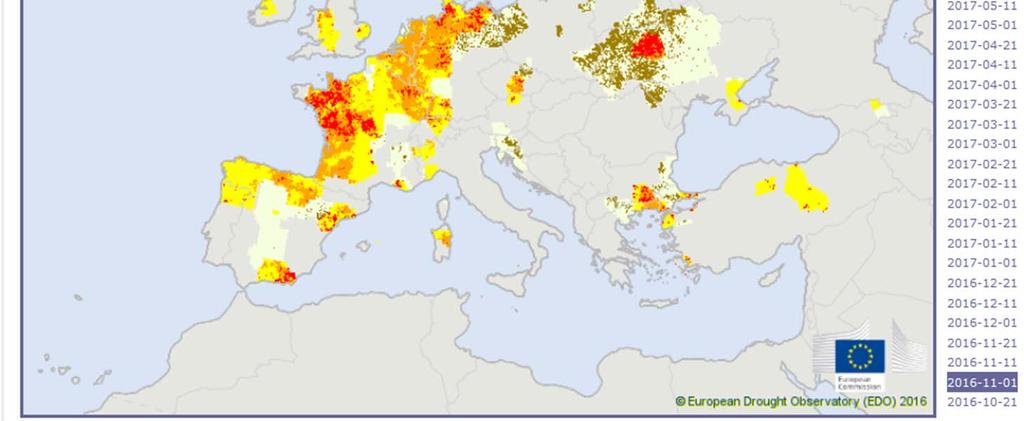
12 CDI Evolution 2017


13 Current Droughts Current Droughts Combined Drought Index Maps Comprehensive Reports EMM Drought News 13
14 Drought Mapping Map viewer Side by Side Maps WMS access Make your own Map 14


15 Analysis / Evolution 15
16 Alfred de Jager Diego Magni European Commission Joint Research Centre
Analytical Report. Drought in the Horn of Africa February Executive summary. Geographical context. Likelihood of drought impact (LDI)
") Executive summary The current drought in the Horn of Africa is affecting especially Somalia, among other countries, in particular the central and southern regions, where most population is located. Overall,
Executive summary The current drought in the Horn of Africa is affecting especially Somalia, among other countries, in particular the central and southern regions, where most population is located. Overall,
Using the EartH2Observe data portal to analyse drought indicators. Lesson 4: Using Python Notebook to access and process data
 Using the EartH2Observe data portal to analyse drought indicators Lesson 4: Using Python Notebook to access and process data Preface In this fourth lesson you will again work with the Water Cycle Integrator
ASSESSMENT OF DIFFERENT WATER STRESS INDICATORS BASED ON EUMETSAT LSA SAF PRODUCTS FOR DROUGHT MONITORING IN EUROPE
 ASSESSMENT OF DIFFERENT WATER STRESS INDICATORS BASED ON EUMETSAT LSA SAF PRODUCTS FOR DROUGHT MONITORING IN EUROPE G. Sepulcre Canto, A. Singleton, J. Vogt European Commission, DG Joint Research Centre,
Drought Bulletin for the Greater Horn of Africa: Situation in June 2011
 Drought Bulletin for the Greater Horn of Africa: Situation in June 2011 Preliminary Analysis of data from the African Drought Observatory (ADO) SUMMARY The analyses of different meteorological and remote
Land Management and Natural Hazards Unit --- DESERT Action 1. Land Management and Natural Hazards Unit Institute for Environment and Sustainability
 Land Management and Natural Hazards Unit --- DESERT Action 1 Monitoring Drought with Meteorological and Remote Sensing Data A case study on the Horn of Africa Paulo Barbosa and Gustavo Naumann Land Management
Richard R. Heim Jr. Michael J. Brewer
 Linking GDIS Data Sets Using the NIDIS Drought Portal Richard R. Heim Jr. Michael J. Brewer NOAA/NESDIS/ Asheville, North Carolina International Global Drought Information System Workshop: Next Steps Caltech
Agrometeorological activities in RHMSS
 Republic of Serbia Republic Hydrometeorological Service of Serbia Agrometeorological activities in RHMSS Department for applied climatology and agrometeorology www.hidmet.gov.rs Meteorological Observing
SPI: Standardized Precipitation Index
 PRODUCT FACT SHEET: SPI Africa Version 1 (May. 2013) SPI: Standardized Precipitation Index Type Temporal scale Spatial scale Geo. coverage Precipitation Monthly Data dependent Africa (for a range of accumulation
Drought News August 2014
 European Drought Observatory (EDO) Drought News August 2014 (Based on data until the end of July) http://edo.jrc.ec.europa.eu August 2014 EDO (http://edo.jrc.ec.europa.eu) Page 2 of 8 EDO Drought News
Global Flood Awareness System GloFAS
 Global Flood Awareness System GloFAS Ervin Zsoter with the help of the whole EFAS/GloFAS team Ervin.Zsoter@ecmwf.int 1 Reading, 8-9 May 2018 What is GloFAS? Global-scale ensemble-based flood forecasting
Analyzing and Visualizing Precipitation and Soil Moisture in ArcGIS
 Analyzing and Visualizing Precipitation and Soil Moisture in ArcGIS Wenli Yang, Pham Long, Peisheng Zhao, Steve Kempler, and Jennifer Wei * NASA Goddard Earth Science Data and Information Services Center
Copernicus Overview. Major Emergency Management Conference Athlone 2017
 Copernicus Overview Major Emergency Management Conference Athlone 2017 Copernicus is a European programme implemented by the European Commission. The services address six thematic areas: land, marine,
The indicator can be used for awareness raising, evaluation of occurred droughts, forecasting future drought risks and management purposes.
 INDICATOR FACT SHEET SSPI: Standardized SnowPack Index Indicator definition The availability of water in rivers, lakes and ground is mainly related to precipitation. However, in the cold climate when precipitation
Advancing Flood Detection and Preparedness through GEOSS Water Services
 Advancing Flood Detection and Preparedness through GEOSS Water Services David K. Arctur University of Texas at Austin Open Geospatial Consortium (OGC) CAHMDA/DAFOH Joint Workshop University of Texas at
EuroGEOSS for Drought - Linking the European Drought Observatory to global and local scales
 EuroGEOSS for Drought - Linking the European Drought Observatory to global and local scales Barbara Hofer, Stefan Niemeyer, EC-JRC INSPIRE Conference 2010 Cracow June 24, 2010 Drought Relevance Droughts
Drought Monitoring with Hydrological Modelling
 st Joint EARS/JRC International Drought Workshop, Ljubljana,.-5. September 009 Drought Monitoring with Hydrological Modelling Stefan Niemeyer IES - Institute for Environment and Sustainability Ispra -
Discovery and Access to Global Water Data, Maps and Services
 Discovery and Access to Global Water Data, Maps and Services David K. Arctur, PhD david.arctur@utexas.edu University of Texas at Austin Open Geospatial Consortium (OGC) Esri International User Conference
Conceptual Modelling within The OGC MetOcean Domain Working Group
 Conceptual Modelling within The OGC MetOcean Domain Working Group 21 st EGOWS Mtg, 1 st -4 th June 2010, ECMWF Dominic Lowe, dominiclowe@stfc.ac.uk British Atmospheric Data Centre, http://badc.nerc.ac.uk
I&CLC2000 in support to new policy initiatives (INSPIRE, GMES,..)
") I&CLC2000 in support to new policy initiatives (INSPIRE, GMES,..) Manfred Grasserbauer, Director Joint Research Centre Institute for Environment and Sustainability 1 IMAGE 2000 European mosaic of satellite
I&CLC2000 in support to new policy initiatives (INSPIRE, GMES,..) Manfred Grasserbauer, Director Joint Research Centre Institute for Environment and Sustainability 1 IMAGE 2000 European mosaic of satellite
Drought Monitoring in Mainland Portugal
 Drought Monitoring in Mainland Portugal 1. Accumulated precipitation since 1st October 2014 (Hydrological Year) The accumulated precipitation amount since 1 October 2014 until the end of April 2015 (Figure
Analytical Report. Drought in Sri Lanka January2017 ERCC Analytical Team and JRC Drought Team 26 January Map
 1. Map 2. Situation analysis Sri Lanka 1 is currently experiencing a severe drought. This drought situation has been caused by a severe lack of rainfall during the last second Inter-monsoon season (IM2)
Transboundary water management with Remote Sensing. Oluf Jessen DHI Head of Projects, Water Resources Technical overview
 Transboundary water management with Remote Sensing Oluf Jessen DHI Head of Projects, Water Resources Technical overview ozj@dhigroup.com Transboundary water management Water management across national
Caribbean Early Warning System Workshop
 Caribbean Early Warning System Workshop Hamonization in Existing EWS April 14-16, 2016 Presenter: Shawn Boyce Caribbean Institute for Meteorology and Hydrology Husbands, St. James Barbados Background Between
Indices and Indicators for Drought Early Warning
 Indices and Indicators for Drought Early Warning ADRIAN TROTMAN CHIEF, APPLIED METEOROLOGY AND CLIMATOLOGY CARIBBEAN INSTITUTE FOR METEOROLOGY AND HYDROLOGY IN COLLABORATION WITH THE NATIONAL DROUGHT MITIGATION
NATIONAL HYDROPOWER ASSOCIATION MEETING. December 3, 2008 Birmingham Alabama. Roger McNeil Service Hydrologist NWS Birmingham Alabama
 NATIONAL HYDROPOWER ASSOCIATION MEETING December 3, 2008 Birmingham Alabama Roger McNeil Service Hydrologist NWS Birmingham Alabama There are three commonly described types of Drought: Meteorological drought
RHOAPS. Real-time Hydrology Ocean Atmosphere Prediction System. Pronunciation: Ropes Motto: More than just THREDDS
 RHOAPS Real-time Hydrology Ocean Atmosphere Prediction System Pronunciation: Ropes Motto: More than just THREDDS Key Aspects Integrated real-time data systems Atmospheric Hydrologic Coastal oceans Societal
Drought forecasting methods Blaz Kurnik DESERT Action JRC
 Ljubljana on 24 September 2009 1 st DMCSEE JRC Workshop on Drought Monitoring 1 Drought forecasting methods Blaz Kurnik DESERT Action JRC Motivations for drought forecasting Ljubljana on 24 September 2009
EuroGEOSS Protected Areas Pilot
 EuroGEOSS Protected Areas Pilot Max Craglia European Commission Joint Research Centre Part 1: the present MyNatura2000 Mobile app. Awareness raising & volunteered data collection. Natura2000 covers 18%
1st JOINT DMCSEE & JRC WORKSHOP Ljubljana, Slovenia September Monday, 21. September 2009
 1st JOINT DMCSEE & JRC WORKSHOP Ljubljana, Slovenia 21. 25. September 2009 Draft Minutes Monday, 21. September 2009 Opening of the workshop: dr. Gregorič (EARS) and dr. Niemeyer (JRC) both coorganizersand
Remote Sensing Applications for Drought Monitoring
 Remote Sensing Applications for Drought Monitoring Amir AghaKouchak Center for Hydrometeorology and Remote Sensing Department of Civil and Environmental Engineering University of California, Irvine Outline
C o p e r n i c u s L a n d M o n i t o r i n g S e r v i c e
 C o p e r n i c u s L a n d M o n i t o r i n g S e r v i c e Integration into existing Snow and Ice Services and draft product specifications Annett BARTSCH b.geos Copernicus High Resolution Snow and
Application and verification of the ECMWF products Report 2007
 Application and verification of the ECMWF products Report 2007 National Meteorological Administration Romania 1. Summary of major highlights The medium range forecast activity within the National Meteorological
Monthly probabilistic drought forecasting using the ECMWF Ensemble system
 Monthly probabilistic drought forecasting using the ECMWF Ensemble system Christophe Lavaysse(1) J. Vogt(1), F. Pappenberger(2) and P. Barbosa(1) (1) European Commission (JRC-IES), Ispra Italy (2) ECMWF,
The Global Flood Awareness System
 The Global Flood Awareness System David Muraro, Gabriele Mantovani and Florian Pappenberger www.globalfloods.eu 1 Forecasting chain using Ensemble Numerical Weather Predictions Flash Floods / Riverine
Drought and Climate Extremes Indices for the North American Drought Monitor and North America Climate Extremes Monitoring System. Richard R. Heim Jr.
 Drought and Climate Extremes Indices for the North American Drought Monitor and North America Climate Extremes Monitoring System Richard R. Heim Jr. NOAA/NESDIS/National Climatic Data Center Asheville,
European Drought Events (Database of meteorological drought events)
") European Drought Events (Database of meteorological drought events) Jonathan Spinoni, PhD European Commission JRC - Unit E1 (Disaster Risk Management) Email: jonathan.spinoni@ec.europa.eu EDO User Meeting,
European Drought Events (Database of meteorological drought events) Jonathan Spinoni, PhD European Commission JRC - Unit E1 (Disaster Risk Management) Email: jonathan.spinoni@ec.europa.eu EDO User Meeting,
C o p e r n i c u s E m e r g e n c y M a n a g e m e n t S e r v i c e f o r e c a s t i n g f l o o d s
 C o p e r n i c u s E m e r g e n c y M a n a g e m e n t S e r v i c e f o r e c a s t i n g f l o o d s Copernicus & Copernicus Services Copernicus EU Copernicus EU Copernicus EU www.copernicus.eu W
Emerging Needs, Challenges and Response Strategy
 Emerging Needs, Challenges and Response Strategy Development of Integrated Observing Systems in China JIAO Meiyan Deputy Administrator China Meteorological Administration September 2011 Geneva Outline
DROUGHT ASSESSMENT USING SATELLITE DERIVED METEOROLOGICAL PARAMETERS AND NDVI IN POTOHAR REGION
 DROUGHT ASSESSMENT USING SATELLITE DERIVED METEOROLOGICAL PARAMETERS AND NDVI IN POTOHAR REGION Researcher: Saad-ul-Haque Supervisor: Dr. Badar Ghauri Department of RS & GISc Institute of Space Technology
Crisis Management and Natural Disasters Overview of JRC operational or pre-operational activities A. Annunziato, D. Al-Khudhairy
 Papagayo, Costarica 3-4 November 2009 Security Science and The Americas 1 Joint Research Centre (JRC) Crisis Management and Natural Disasters Overview of JRC operational or pre-operational activities A.
Satellite data for hydrological forecasting
 Satellite data for hydrological forecasting Current use at ECMWF and perspective Shopping list! Our current tools does not allow direct use, but could be modified Christel Prudhomme Christel.prudhomme@ecmwf.int
Customizable Drought Climate Service for supporting different end users needs
 1 Customizable Drought Climate Service for supporting different end users needs Ramona MAGNO, T. De Filippis, E. Di Giuseppe, M. Pasqui, E. Rapisardi, L. Rocchi (IBIMET-CNR; LaMMA Consortium) 1 Congresso
L.A.OGALLO IGAD Climate Prediction and Applications Centre (ICPAC) Formerly known as Drought Monitoring Centre - Nairobi (DMCN)
 Formerly known as Drought Monitoring Centre - Nairobi (DMCN)") METEOROLOGICAL DROUGHT EARLY WARNING IN AFRICA L.A.OGALLO IGAD Climate Prediction and Applications Centre (ICPAC) Formerly known as Drought Monitoring Centre - Nairobi (DMCN) INTRODUCTION DROUGHT IS A
METEOROLOGICAL DROUGHT EARLY WARNING IN AFRICA L.A.OGALLO IGAD Climate Prediction and Applications Centre (ICPAC) Formerly known as Drought Monitoring Centre - Nairobi (DMCN) INTRODUCTION DROUGHT IS A
Country Presentation-Nepal
 Country Presentation-Nepal Mt.Everest, Shiva Pd. Nepal, DHM South Asia Drought Monitor Workshop Dhaka Bangladesh 2 th April 215 Overview Brief Climatology Climate activities- DHM PPCR (Pilot Program for
Explore African and Global early warning systems Climate Change effects on water cycle: Flood Risk. Revised website:
 JRC research activities on floods 1 Flood early warning (Europe) EFAS: European Flood Alert System IMPRINTS (DG RTD project): flash flood early warning EU-FLOOD-GIS ETN-R Explore African and Global early
István Ihász, Hungarian Meteorological Service, Budapest, Hungary
 Experiences using VarEPS products at the Hungarian Meteorological Service István Ihász, Hungarian Meteorological Service, Budapest, Hungary 1 Introduction ECMWF 15 day Variable Resolution Ensemble Prediction
Regional Drought Decision Support System (RDDSS) Project Update and Product Concepts
 Project Update and Product Concepts") Regional Drought Decision Support System (RDDSS) Project Update and Product Concepts Part of the Red River Basin Decision Information Network (RRBDIN) NEXT-GEN RRBDIN Decision Support for the Red River
Regional Drought Decision Support System (RDDSS) Project Update and Product Concepts Part of the Red River Basin Decision Information Network (RRBDIN) NEXT-GEN RRBDIN Decision Support for the Red River
Finnish Open Data Portal for Meteorological Data
 18.11.2013 1 Finnish Open Data Portal for Meteorological Data 14th Workshop on meteorological operational systems Roope Tervo Finnish Meteorological Institute Example of Data Sets -- Observations Data
Drought Management Centre for Southeastern Europe. Introduction. Gregor Gregorič Slovenian Environmental Agency
 Drought Management Centre for Southeastern Europe Introduction Gregor Gregorič Slovenian Environmental Agency Contents Description of DMCSEE process Introduction of the DMCSEE TCP project Introduction
The benefits and developments in ensemble wind forecasting
 The benefits and developments in ensemble wind forecasting Erik Andersson Slide 1 ECMWF European Centre for Medium-Range Weather Forecasts Slide 1 ECMWF s global forecasting system High resolution forecast
The Delaware Environmental Monitoring & Analysis Center
 The Delaware Environmental Monitoring & Analysis Center Tina Callahan Delaware Estuary Science & Environmental Summit 2013 January 27-30, 2013 What is DEMAC? Delaware Environmental Monitoring & Analysis
D.5.1: report on user requirements for the EuroGEOSS Drought operating capacity Revised Version
 Project start date: 01 May 2009 Acronym: EuroGEOSS Project title: EuroGEOSS, a European Theme: FP7-ENV-2008-1: Environment (including climate change) Theme title: ENV.2008.4.1.1.1: European Environment
World Meteorological Organization OMAR BADDOUR WMO
 World Meteorological Organization Working together in weather, climate and water Improving WMO operational climate monitoring in support of the GFCS OMAR BADDOUR WMO WMO www.wmo.int WMO WMO OMM Operational
ANALYSIS OF FLOODS AND DROUGHTS IN THE BAGO RIVER BASIN, MYANMAR, UNDER CLIMATE CHANGE
 ANALYSIS OF FLOODS AND DROUGHTS IN THE BAGO RIVER BASIN, MYANMAR, UNDER CLIMATE CHANGE Myo Myat Thu* MEE15631 ABSTRACT 1 Supervisor: Dr. Maskym Gusyev** Dr. Akira Hasegawa** This study investigates floods
Development of the Canadian Precipitation Analysis (CaPA) and the Canadian Land Data Assimilation System (CaLDAS)
 and the Canadian Land Data Assimilation System (CaLDAS)") Development of the Canadian Precipitation Analysis (CaPA) and the Canadian Land Data Assimilation System (CaLDAS) Marco L. Carrera, Vincent Fortin and Stéphane Bélair Meteorological Research Division Environment
Development of the Canadian Precipitation Analysis (CaPA) and the Canadian Land Data Assimilation System (CaLDAS) Marco L. Carrera, Vincent Fortin and Stéphane Bélair Meteorological Research Division Environment
Crop and pasture monitoring in Eritrea
 JRC SCIENTIFIC AND POLICY REPORTS Crop and pasture monitoring in Eritrea Kremti rainy season started with substantial delay Ana Pérez-Hoyos, Francois Kayitakire, Hervé Kerdiles, Felix Rembold, Olivier
Flood Forecasting. Fredrik Wetterhall European Centre for Medium-Range Weather Forecasts
 Flood Forecasting Fredrik Wetterhall (fredrik.wetterhall@ecmwf.int) European Centre for Medium-Range Weather Forecasts Slide 1 Flooding a global challenge Number of floods Slide 2 Flooding a global challenge
High Resolution Indicators for Local Drought Monitoring
 High Resolution Indicators for Local Drought Monitoring REBECCA CUMBIE, STATE CLIMATE OFFICE OF NC, NCSU Monitoring Drought Multiple indicators, multiple sources Local detail important 1 Point-Based Climate-Division
12/07/2017. Flash Flood Warning Service, an advanced approach towards flood resilient cities Floodplain Management Association Conference, Newcastle
 12/07/2017 Worldwide problem: Flash Floods Flash Floods are a Global Problem Flash Flood Warning Service, an advanced approach towards flood resilient cities Floodplain Management Association Conference,
2006 Drought in the Netherlands (20 July 2006)
") 2006 Drought in the Netherlands (20 July 2006) Henny A.J. van Lanen, Wageningen University, the Netherlands (henny.vanlanen@wur.nl) The Netherlands is suffering from tropical heat and it is facing a meteorological
2006 Drought in the Netherlands (20 July 2006) Henny A.J. van Lanen, Wageningen University, the Netherlands (henny.vanlanen@wur.nl) The Netherlands is suffering from tropical heat and it is facing a meteorological
From a North American to a Global Drought Monitor Richard R. Heim Jr.
 From a North American to a Global Drought Monitor Richard R. Heim Jr. NOAA/NESDIS/ Asheville, North Carolina, USA GEO-DRI Drought Monitoring Workshop Winnipeg, Manitoba, Canada 10-11 May 2010 NADM History
ASCAT-B Level 2 Soil Moisture Validation Report
 EUMETSAT EUMETSAT Allee 1, D-64295 Darmstadt, Doc.No. : EUM/OPS/DOC/12/3849 Germany Tel: +49 6151 807-7 Issue : v2 Fax: +49 6151 807 555 Date : 20 December 2012 http://www.eumetsat.int Page 1 of 25 This
Weather and climate outlooks for crop estimates
 Weather and climate outlooks for crop estimates CELC meeting 2016-04-21 ARC ISCW Observed weather data Modeled weather data Short-range forecasts Seasonal forecasts Climate change scenario data Introduction
Services for Inland Marine Data Integration. USGS Center for Integrated
 Services for Inland Marine Data Integration USGS Center for Integrated Data Analytics Outline GeoDataPortal Tools Coastal Use Cases Beach hhealth lthmodeling Distributed Rainfall Analysis for Integration
RHMSS and SEEVCCC activities in support of GFCS
 RHMSS and SEEVCCC activities in support of GFCS Goran Pejanovic Assistant Director of RHMSS 21-22. November 2014, Antalya, Turkey Capacities for the management of climatic data 30 main meteorological stations
Water information system advances American River basin. Roger Bales, Martha Conklin, Steve Glaser, Bob Rice & collaborators UC: SNRI & CITRIS
 Water information system advances American River basin Roger Bales, Martha Conklin, Steve Glaser, Bob Rice & collaborators UC: SNRI & CITRIS Opportunities Unprecedented level of information from low-cost
NIDIS Intermountain West Drought Early Warning System September 4, 2018
 NIDIS Drought and Water Assessment NIDIS Intermountain West Drought Early Warning System September 4, 2018 Precipitation The images above use daily precipitation statistics from NWS COOP, CoCoRaHS, and
Evaporative Fraction and Bulk Transfer Coefficients Estimate through Radiometric Surface Temperature Assimilation
 Evaporative Fraction and Bulk Transfer Coefficients Estimate through Radiometric Surface Temperature Assimilation Francesca Sini, Giorgio Boni CIMA Centro di ricerca Interuniversitario in Monitoraggio
GeoPEARL_DE a Tool for Spatial Modelling of Pesticide Leaching Behaviour in Germany. Jörg Bangert
 GeoPEARL_DE a Tool for Spatial Modelling of Pesticide Leaching Behaviour in Germany Jörg Bangert Agenda Development of GeoPEARL_DE o Data sources o Spatial schematisation o Parameterisation Evaluation
IGAD CLIMATE PREDICTION AND APPLICATIONS CENTRE (ICPAC) UPDATE OF THE ICPAC CLIMATE WATCH REF: ICPAC/CW/NO. 24, AUGUST 2011
 UPDATE OF THE ICPAC CLIMATE WATCH REF: ICPAC/CW/NO. 24, AUGUST 2011") IGAD CLIMATE PREDICTION AND APPLICATIONS CENTRE (ICPAC) UPDATE OF THE ICPAC CLIMATE WATCH REF: ICPAC/CW/NO. 24, AUGUST 2011 SUMMARY Drought conditions have persisted over some parts of the Arid and semi-arid
IGAD CLIMATE PREDICTION AND APPLICATIONS CENTRE (ICPAC) UPDATE OF THE ICPAC CLIMATE WATCH REF: ICPAC/CW/NO. 24, AUGUST 2011 SUMMARY Drought conditions have persisted over some parts of the Arid and semi-arid
LAYMAN S REPORT Floods and Fire Risk Assessment and Management
 LAYMAN S REPORT Floods and Fire Risk Assessment and Management FLIRE is 50% co-financed by LIFE + financial instrument of the European Union. Floods and Fire risk assessment and management Project s code
Creating a WeatherSMART nation: SAWS drought related research, services and products
 Creating a WeatherSMART nation: SAWS drought related research, services and products Drought Dialogue 23-24 June 2016 Western Cape Government Hannes Rautenbach South African Weather Service SAWS mandate
The North American Drought Monitor - The Canadian Perspective -
 The North American Drought Monitor - The Canadian Perspective - Trevor Hadwen National Agroclimate Information Service AAFC-PFRA, Regina Canmore, Alberta March 16-18, 2008 Background The NADM is a cooperative
Application and verification of ECMWF products 2009
 Application and verification of ECMWF products 2009 RHMS of Serbia 1. Summary of major highlights ECMWF products are operationally used in Hydrometeorological Service of Serbia from the beginning of 2003.
SWIM and Horizon 2020 Support Mechanism
 SWIM and Horizon 2020 Support Mechanism Working for a Sustainable Mediterranean, Caring for our Future REG-7: Training Session #1: Drought Hazard Monitoring Example from real data from the Republic of
April Figure 1: Precipitation Pattern from for Jamaica.
 April 2018 Introduction This rainfall summary is prepared by the Climate Branch of the Meteorological Service, Jamaica. The Meteorological Service maintains a network of approximately one hundred and seventy
Fusarium Head Blight (FHB)
") Fusarium Head Blight (FHB) FHB is a Fungal disease of cereal crops that affects kernel development 1999 declared a pest under the Agricultural Pest Act 2002 Alberta released Fusarium Risk Management Plan
Fusarium Head Blight (FHB) FHB is a Fungal disease of cereal crops that affects kernel development 1999 declared a pest under the Agricultural Pest Act 2002 Alberta released Fusarium Risk Management Plan
Seasonal prediction of extreme events
 Seasonal prediction of extreme events C. Prodhomme, F. Doblas-Reyes MedCOF training, 29 October 2015, Madrid Climate Forecasting Unit Outline: Why focusing on extreme events? Extremeness metric Soil influence
2015 Fall Conditions Report
 2015 Fall Conditions Report Prepared by: Hydrologic Forecast Centre Date: December 21 st, 2015 Table of Contents Table of Figures... ii EXECUTIVE SUMMARY... 1 BACKGROUND... 2 SUMMER AND FALL PRECIPITATION...
Land atmosphere atmosphere coupling: How satellite LST data contribute to drought assessment and yield prediction
 Land atmosphere atmosphere coupling: How satellite LST data contribute to drought assessment and yield prediction Julia Stoyanova & Christo Georgiev National Institute of Meteorology and Hydrology (NIMH),
National Report on Weather Forecasting Service
 MINISTRY OF WATER RESOURCES AND METEOROLOGY DEPARTMENT OF METEOROLOGY, CAMBODIA National Report on Weather Forecasting Service Tokyo, 11-15 March 2014 Department of Meteorology, Cambodia Presentation Outline
REMOTELY SENSED INFORMATION FOR CROP MONITORING AND FOOD SECURITY
 LEARNING OBJECTIVES Lesson 4 Methods and Analysis 2: Rainfall and NDVI Seasonal Graphs At the end of the lesson, you will be able to: understand seasonal graphs for rainfall and NDVI; describe the concept
NIDIS Intermountain West Drought Early Warning System August 8, 2017
 NIDIS Drought and Water Assessment 8/8/17, 4:43 PM NIDIS Intermountain West Drought Early Warning System August 8, 2017 Precipitation The images above use daily precipitation statistics from NWS COOP,
Joint Meeting of RA II WIGOS Project and RA V TT-SU on 11 October 2018 BMKG Headquarter Jakarta, Indonesia. Mrs. Sinthaly CHANTHANA
 Joint Meeting of RA II WIGOS Project and RA V TT-SU on 11 October 2018 BMKG Headquarter Jakarta, Indonesia Mrs. Sinthaly CHANTHANA Lao PDR Background Department of Meteorology and Hydrology ( DMH ) in
Overview of the TAMSAT drought forecasting system
 Overview of the TAMSAT drought forecasting system The TAMSAT drought forecasting system produces probabilistic forecasts of drought by combining information on the contemporaneous condition of the land
GIS in Weather and Society
 GIS in Weather and Society Olga Wilhelmi Institute for the Study of Society and Environment National Center for Atmospheric Research WAS*IS November 8, 2005 Boulder, Colorado Presentation Outline GIS basic
Operational Monsoon Monitoring at NCEP
 Operational Monsoon Monitoring at NCEP Wassila M. Thiaw Climate Prediction Center National Centers for Environmental Predictions Operational Monsoon Monitoring at NCEP Wassila M. Thiaw Climate Prediction
EUMETSAT SAF NETWORK. Lothar Schüller, EUMETSAT SAF Network Manager
 1 EUMETSAT SAF NETWORK Lothar Schüller, EUMETSAT SAF Network Manager EUMETSAT ground segment overview METEOSAT JASON-2 INITIAL JOINT POLAR SYSTEM METOP NOAA SATELLITES CONTROL AND DATA ACQUISITION FLIGHT
HIGHLIGHTS. All thirteen parishes received below-normal rainfall in July.
 AGROMET BULLETIN Volume 6. No. 7 July 2018 HIGHLIGHTS All thirteen parishes received below-normal rainfall in July. Except for Trelawny and St. Catherine, all other parishes recorded meteorological drought
The Safeland Project General Overview and Monitoring Technology Development
 Ber. Geol. B. A., 82, ISSN 1017 8880 Landslide Monitoring Technologies & Early Warning Systems The Safeland Project General Overview and Monitoring Technology Development The SafeLand Consortium a), N.
United States Multi-Hazard Early Warning System
 United States Multi-Hazard Early Warning System Saving Lives Through Partnership Lynn Maximuk National Weather Service Director, Central Region Kansas City, Missouri America s s Weather Enterprise: Protecting
The Palfai Drought Index (PaDI) Expansion of applicability of Hungarian PAI for South East Europe (SEE) region Summary
 Expansion of applicability of Hungarian PAI for South East Europe (SEE) region Summary") The Palfai Drought Index () Expansion of applicability of Hungarian PAI for South East Europe (SEE) region Summary In Hungary the Palfai drought index (PAI) worked out for users in agriculture and in water
The Palfai Drought Index () Expansion of applicability of Hungarian PAI for South East Europe (SEE) region Summary In Hungary the Palfai drought index (PAI) worked out for users in agriculture and in water
NIDIS Intermountain West Drought Early Warning System November 14, 2017
 NIDIS Intermountain West Drought Early Warning System November 14, 2017 Precipitation The images above use daily precipitation statistics from NWS COOP, CoCoRaHS, and CoAgMet stations. From top to bottom,
Measures Also Significant Factors of Flood Disaster Reduction
 Non-Structual Measures Also Significant Factors of Flood Disaster Reduction Babiaková Gabriela, Leškov ková Danica Slovak Hydrometeorological Institute, Bratislava Hydrological Forecasts and Warning Department
Applications of yield monitoring systems and agricultural statistics in agricultural (re)insurance
insurance") Image: used under license from shutterstock.com Applications of yield monitoring systems and agricultural statistics in agricultural (re)insurance 18 October 2018 Ernst Bedacht Agenda Introduction 1. Munich
Image: used under license from shutterstock.com Applications of yield monitoring systems and agricultural statistics in agricultural (re)insurance 18 October 2018 Ernst Bedacht Agenda Introduction 1. Munich
Using R for time series analysis and spatial-temporal distribution of global burnt surface multi-year product
 Using R for time series analysis and spatial-temporal distribution of global burnt surface multi-year product Jedrzej Bojanowski* César Carmona-Moreno European Commission - Joint Research Centre Institute
ISPRS Archive Vol. XXXVIII, Part W9, "Core Spatial Databases - Updating, Maintenance and Services from Theory to Practice", Haifa, Israel, 2010
 INTEGRATED SYSTEM OF EARLY WARNING, MONITORING AND DROUGHT RISK ANALYSIS FOR ROMANIA E. Savin, a, *, D. Mihailescu b, S. Oancea b, A. Diamandi b, M. Caian b, A. Nertan b, V. Poenaru a a ROSA, Romanian
Fire Weather Monitoring and Predictability in the Southeast
 Fire Weather Monitoring and Predictability in the Southeast Corey Davis October 9, 2014 Photo: Pains Bay fire in 2011 (courtesy Donnie Harris, NCFWS) Outline Fire risk monitoring Fire risk climatology
Global Challenges - Partnering with Service Providers. World Meteorological Organization. J. Lengoasa WMO Deputy Secretary-General
 WMO World Meteorological Organization Working together in weather, climate and water Global Challenges - Partnering with Service Providers J. Lengoasa WMO Deputy Secretary-General jlengoasa@wmo.int http://www.wmo.int/pages/gfcs/gfcs_en.html