Two case history of EMS data application: earthquake in central italy and flooding in Piedmont region
|
|
|
- Christine Miller
- 5 years ago
- Views:
Transcription


1 Two case history of EMS data application: earthquake in central italy and flooding in Piedmont region Luca Lanteri*, Rocco Pispico*, R. Cremonini** *Arpa Piemonte, Geological and Natural Risk Dipartiment **Arpa Piemonte, Previsional Department Contact:

2 Overview of our organization ARPA - The Regional Agency for the Protection of the Environment of Piedmont is a public authority with independent administrative, technicaljuridical status. It operates under the oversight of the Regional Government to ensure compliance with the policy guidelines in the fields of forecasting, preventive actions and preservation of the environment Geological and Natural Risk Department - about 15 technician Previsional Metereological Department - about 35 technician

3 Overview of our organization Our activities Prediction and prevention of anthropic and natural risks Activities of conformity control on installations Water, soil and air quality monitoring Reports on the environment conditions Weather forecast service In case of heavy rain event, ARPA has 24/7 service to control weather forecast and hydrological status of slopes and rivers In italy Copernicus activation is in charge to National Department of Civil Protection (Autorized user)
 Bardonecchia, Crollo loc.")
4 Analisys, definition and updating of natural processes framework (landslides, flooding, avalanche etc...) Bardonecchia, Crollo loc. Melezet, 2009

5 Manage of monitoring landslides networks Gestione della rete di Controllo dei Movimenti Franosi e della rete di stazioni GPS permanenti Novalesa, Rocciamelone landslide, 2010

6 Survey and data collection after flooding events Dora Baltea, flooding 2000

7 Support to National Department of Civil Protection to manage survey on building status after eartquake of 24 august in central Italy L'Aquila, aprile 2009

 and")


8 Use of products: Centre Italy earthquake The 24th August 2016 an earthquake occurred in the centre of Italy involving a very large territory including four Regions (Lazio, Abruzzo, Umbria) and Municipalities. After the main shock several others, in particular 26th of October and 18 January 2017, occurred in the areas producing casualties and damages on structures and infrastructures. EMSR190 EMSR177 EMSR194

9 Use of products: Centre Italy earthquake Region and ARPA developed ERIKUS an open source software based on QGIS and Postgres/Postgis technologies in order to aid the manage of field building status survey after the earthquake and to manage the data. We provide support directly to the municipalityes for the installation, training and maintenance of ERIKUS and to DPCN status to data collection, manage and spreading. Since the end of august 2016 more than 190 municipalities collect data with ERIKUS
10 Use of products: Centre Italy earthquake Need Scheduled Time Purpose days first-emergency first phase: Organize the field survey on buildings Up to 6 month emergency second phase: Data managment, validation and organization 1 years post-emergency third phase: Provide a more detailed and organized data for reconstruction phase future knowledge, pianification
 Experimentation to compare grading information from EMS with field survey (AEDES and FAST forms) in perspective for future events")
11 Use of products: Centre Italy earthquake Municipality Coordination Center (COC) use Tile Map Service as the most updated base cartography (where available) for QGIS (ERIKUS project) Experimentation to compare grading information from EMS with field survey (AEDES and FAST forms) in perspective for future events

12 Use of products: 24 august earthquake. Data comparison Illica - Accumoli Percentage of success on: - Damaged building 90% - Moderately affected 5% - Not affected 30% TOTAL SCORE 65%

13 Grisciano - Accumoli Use of products: 24 august earthquake. Data comparison Percentage of success on: - Damaged building 100% - Moderately affected 7% - Not affected 25% TOTAL SCORE 28%

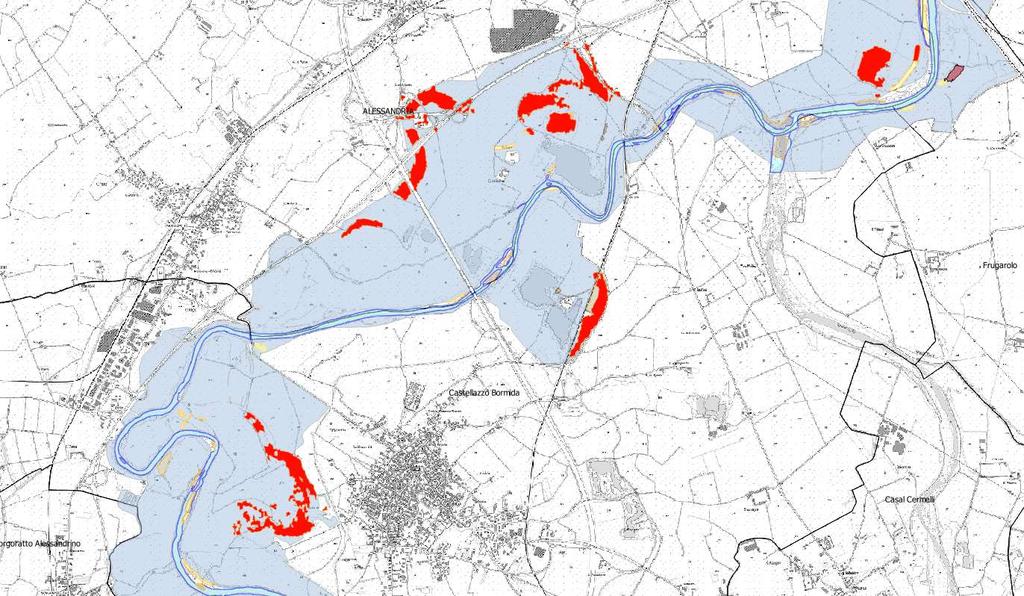
14 On whole dataset TOTAL SCORE 25% Use of products: 24 august earthquake. Data comparison 55% 31%


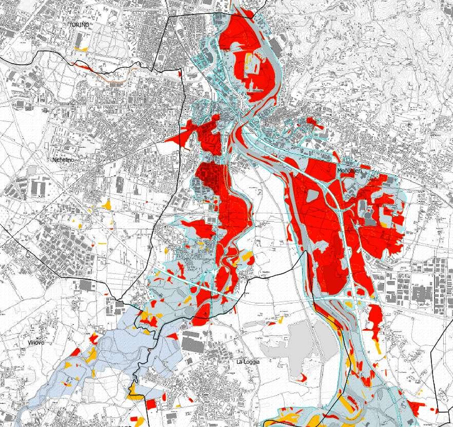
15 Starting from November 22nd, heavy rainfalls are involving the territory of North West of Italy, in particular the Regions of Piemonte and Liguria. The bad weather conditions and the persistence of precipitations have caused the increasing of hydrometric levels of all the rivers in particular in the basin of Po river.
16 first phase: Need rapid damage assessment and collection of information for a briefly regional report Scheduled Time Purpose 15 day emergency second phase: reconstruct a more detailed framework of the event 1 year knowledge, pianification Arpa & Regional Amministration worked together in field survey
17 On 24 november the National Department of Civil Protection triggered the national and european monitoring services In order to monitoring Po, Tanaro Bormida and other minor river flooding: Copernicus Emergency Management Service (EMS) - European level The Italian Spatial Agency (ASI) with CIMA Foundation - National level
18 Copernicus had provided two product into EMSR192 activation: Delineation maps provide an assessment of the event extent (and of its evolution if requested). Delineation maps are derived from satellite postdisaster images. They vary depending on the disaster type and the delineation of the areas impacted by the disaster. Grading maps provide an assessment of the damage grade. Grading maps are derived from post-event satellite images. Grading maps include the extent, magnitude or damage grades specific to each disaster type. They may also provide relevant and up-to-date information that is specific to affected population and assets, e.g. settlements, transport networks, industry and utilities.
 On 30.11.2016 and 01.12.2016 Piedmont Regione made an airborne photographic survey on Tanaro, Bormida and Chisola rivers")
19 Data derived from different satellites: Delineation - mainly using semiautomatic procedure from radar images (Radarsat-2 and Cosmo Skymed) Grading evaluation of damages from very high resolution optical images (Pleiades, SPOT) On and Piedmont Regione made an airborne photographic survey on Tanaro, Bormida and Chisola rivers

20 CIMA (International Centre on environmental monitoring) produced an assesment of the flooded area starting from RADARSAT-2 images using a semiautomatic elaboration Dataset :20 Dataset :20 Dataset :15

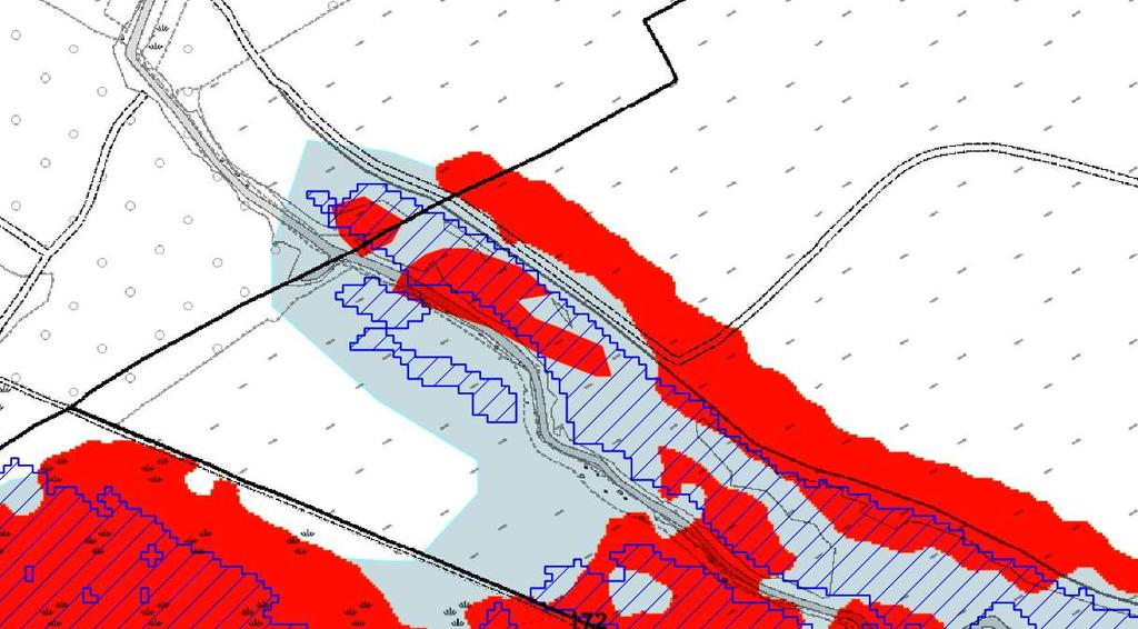
21 Location: Bormida Valley Map type: Delineation Platform: Radarsat-2 Imagery date: :37 Other data: Airborne photo Field survey Radarsat-2
22

23 Radarsat-2: :50 Airborne images: Water
24 Analyzed area: from Sezzadio to Alessandria (about 18km) Flooded area: Field survey 21,39 sq km EMS 5,82 sq km EMS/Field survey = 27,2% Low flooded area detected Area with water 4 days after no detected

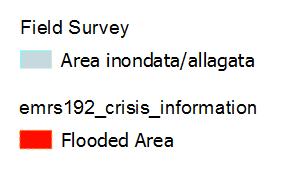
25 Location: Po Valley, from castagneto to crescentino Map type: Delineation Platform: Radarsat-2 Imagery date: :37 Other data: CIMA flooded areas Field survey
26
27
28 100m
 Both have a good match with field")
29 Po flooded area from Castagneto to Verrua Savoia (about 13 km) Field survey 18,8 sq km EMS 7,7 sq km EMS/Field survey 40,9% Georeferencing differerence about 100m Cima and EMS elaborations have a good match (same area identified as flooded) Both have a good match with field survey
 Imagery date: 2016-11-27 16:37")
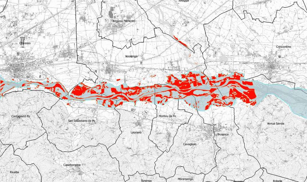
30 Location: Chisola-Po confluence (Moncalieri & Turin Municipalities) Map type: Grading Platform: Pleiades (very high resolution optical data) Imagery date: :37
31
32 Chisola - PO Flooded at N of Highway Field survey EMS 9,2 sq km 5,3 sq km EMS/Field survey 57,6% High match form EMS, CIMA and Arpa survey No false positives (all areas indicated as flooded confirmed by field survey)

33 Final considerations and suggestion for improvement Copernicus EMS is very useful data in our work In this two cases we work on wide areas. Satellite data is the right tool to quickly cover large areas. Consider extending the imagery acquisition area as much as possible. The availability of raw data are fundamental (TIFF, WMS, TMS, and WFS), maintaining imagery and vector data separated Avability of very high resolution optical data (SPOT, Pleiades and airborne imagery) are a remarkable added value in our work

34 Final considerations and suggestion for improvement Arpa can contribuite to provide detailed field data that can be used for validation in order to improve future analisys Arpa Technicians have a in-depth knowledge of the hazards and natural processes affecting the Piedmont territory, so they can provide an expert reading key to understand EMS data Arpa and Regional Cartographic Department detain many others base and tematic data available for integration into Copernicus data
35 THANKS FOR THE ATTENTION Contatti: A special thanks to: - Simone Dalmasso (JRC) for kindly support to our work - All Regional & Arpa collegues of flood working group - All friends of ERIKUS working group
Copernicus Overview. Major Emergency Management Conference Athlone 2017
 Copernicus Overview Major Emergency Management Conference Athlone 2017 Copernicus is a European programme implemented by the European Commission. The services address six thematic areas: land, marine,
Geology and the inventory of natural risks. Luca Lanteri
 Geology and the inventory of natural risks Luca Lanteri Exchange (Brazil-EC) for free open source software for GIS Torino 11 luglio 2016 Analysis, definition and updating at regonal scale of natural modelling
Copernicus Overview and Emergency Management Service
 Copernicus Overview and Emergency Management Service Frédéric BASTIDE European Commission Open informal session of the United Nations Inter-Agency Meeting on Outer Space Activities 12 March 2013, Geneva
Effective Utilization of Synthetic Aperture Radar (SAR) Imagery in Rapid Damage Assessment
 Imagery in Rapid Damage Assessment") Effective Utilization of Synthetic Aperture Radar (SAR) Imagery in Rapid Damage Assessment Case Study Pakistan Floods SUPARCO M. Maisam Raza, Ahmad H. Rabbani SEQUENCE Flood Monitoring using Satellite
Effective Utilization of Synthetic Aperture Radar (SAR) Imagery in Rapid Damage Assessment Case Study Pakistan Floods SUPARCO M. Maisam Raza, Ahmad H. Rabbani SEQUENCE Flood Monitoring using Satellite
The PREVIEW project: general objectives and an overview of the landslides platform
 The PREVIEW project: general objectives and an overview of the landslides platform Risk Mitigation for Earthquakes and Landslides Giacomo Falorni Earth Sciences Dept. University of Firenze 19-20 July 2007
Airbus DS Consortium Risk and Recovery. Airbus DS Corporate Presentation
 Airbus DS Consortium Risk and Recovery 1 January, 2017 Airbus DS Corporate Presentation 2 SERTIT s Copernicus EMS mapping service Risk & Recovery and Rapid Mapping Based on our 24/7/365 operational rapid
Emergency Management Service (EMS) mapping
 mapping") GMES Emergency Management Service (EMS) mapping Frédéric BASTIDE GMES unit, European Commission UN-SPIDER Expert Meeting: "Crowdsource Mapping for Disaster Risk Management and Emergency Response" 3-5 December,
GMES Emergency Management Service (EMS) mapping Frédéric BASTIDE GMES unit, European Commission UN-SPIDER Expert Meeting: "Crowdsource Mapping for Disaster Risk Management and Emergency Response" 3-5 December,
Innovative Ways to Monitor Land Displacement
 ARTICLE Innovative Ways to Monitor Land Displacement When people think about landslides, they usually imagine large mud streams which cause considerable loss of life. Whereas such large-scale disasters
L i n k i n g f l o o d i m p a c t f o r e c a s t i n g a n d s a t e l l i t e r a p i d m a p p i n g i n E u r o p e
 L i n k i n g f l o o d i m p a c t f o r e c a s t i n g a n d s a t e l l i t e r a p i d m a p p i n g i n E u r o p e Francesco Dottori, Milan Kalas, Peter Salamon, Annett Wania, Ines Rivero (EC JRC)
Involvement of the Geological Survey of Slovenia in the field of natural hazard risk management
 Involvement of the Geological Survey of Slovenia in the field of natural hazard risk management Špela Kumelj, Mateja Jemec-Auflič, Jernej Jež, Tina Peternel, Blaž Milanič Geohazard group, GeoZS COMLAND
Landslide Hazard Assessment Methodologies in Romania
 A Scientific Network for Earthquake, Landslide and Flood Hazard Prevention SciNet NatHazPrev Landslide Hazard Assessment Methodologies in Romania In the literature the terms of susceptibility and landslide
The Civil Protection System of the Autonomous Region of Friuli Venezia Giulia (Italy)
") The Civil Protection System of the Autonomous Region of Friuli Venezia Giulia (Italy) Geol. Raffaele Lotto La Plata, November 2017 Friuli Venezia Giulia Autonomous Region Austria Pordenone Udine Gorizia
The Civil Protection System of the Autonomous Region of Friuli Venezia Giulia (Italy) Geol. Raffaele Lotto La Plata, November 2017 Friuli Venezia Giulia Autonomous Region Austria Pordenone Udine Gorizia
Copernicus Information & Training Session
 Copernicus Information & Training Session Copernicus Emergency Management Service Dora Aifantopoulou GEOAPIKONISIS S.A.P.GE. Copernicus EU Copernicus EU Copernicus EU www.copernicus.eu Athens 07.10.2016
GMES EURORISK Geo-information services for natural and man-made risks management
 GMES EURORISK Geo-information services for natural and man-made risks management 8/11/2004 EURORISK A European scale approach for developing, delivering and operationally exploiting new information services
I&CLC2000 in support to new policy initiatives (INSPIRE, GMES,..)
") I&CLC2000 in support to new policy initiatives (INSPIRE, GMES,..) Manfred Grasserbauer, Director Joint Research Centre Institute for Environment and Sustainability 1 IMAGE 2000 European mosaic of satellite
I&CLC2000 in support to new policy initiatives (INSPIRE, GMES,..) Manfred Grasserbauer, Director Joint Research Centre Institute for Environment and Sustainability 1 IMAGE 2000 European mosaic of satellite
Landslide monitoring system in Iceland. Harpa Grímsdóttir Jón Kristinn Helgason NVE, Oslo, October
 Landslide monitoring system in Iceland Harpa Grímsdóttir Jón Kristinn Helgason NVE, Oslo, October 26 2016 History Avalanches and landslides have caused extensive damages and loss of human lives in Iceland
GI Technology for Disaster Management
 GI Technology for Disaster Management 17 th ICC on the Regional Space Applications Programme for Sustainable Development (RESAP) 26 th Nov 2013 Bangkok Thailand Period and time of seasonal in thailand
C o p e r n i c u s E m e r g e n c y M a n a g e m e n t S e r v i c e f o r e c a s t i n g f l o o d s
 C o p e r n i c u s E m e r g e n c y M a n a g e m e n t S e r v i c e f o r e c a s t i n g f l o o d s Copernicus & Copernicus Services Copernicus EU Copernicus EU Copernicus EU www.copernicus.eu W
ÖBB Natural Hazard Management
 ÖBB Natural Hazard Management Management of Weather Events in the Austrian Federal Railways MOWE-IT, Brussels 17 th of September 2013 DI Günther Kundela Integrated Track Management Integration Technic
European Drought Observatory Progress on Drought Monitoring
 European Drought Observatory Progress on Drought Monitoring Alfred de Jager Diego Magni European Commission Joint Research Centre (JRC) Disaster Risk Management Unit Outline 1. Introduction Philosophy
User Awareness & Training Event: Parallel 3c EMERGENCY (Room 1) Bucharest, Romania 7 th November 2013 A.Priolo, D.Grandoni
 Bucharest, Romania 7 th November 2013 A.Priolo, D.Grandoni") User Awareness & Training Event: Parallel 3c EMERGENCY (Room 1) Bucharest, Romania 7 th November 2013 A.Priolo, D.Grandoni Content Demo and Training Module 2: Live Demonstration: GIO Emergency services
User Awareness & Training Event: Parallel 3c EMERGENCY (Room 1) Bucharest, Romania 7 th November 2013 A.Priolo, D.Grandoni Content Demo and Training Module 2: Live Demonstration: GIO Emergency services
THE ADRIARadNet PROJECT
 THE ADRIARadNet PROJECT Activity carried out by Abruzzo Region: Results, problems, aims A. Santacasa, G. Ragni, L. Tontodimamma, F. Rossi, A. Cimoroni, B. Di Giacomantonio, A. Iovino The main project activities
Cosmo model validation through precipitation data coming from radar-based estimation and rain gauges measures
 Cosmo model validation through precipitation data coming from radar-based estimation and rain gauges measures Naima Vela, Roberto Cremonini, Renzo Bechini, Elena Oberto, Daniele Gandini September 2, 2013
GEOMATICS. Shaping our world. A company of
 GEOMATICS Shaping our world A company of OUR EXPERTISE Geomatics Geomatics plays a mayor role in hydropower, land and water resources, urban development, transport & mobility, renewable energy, and infrastructure
Emerging Needs, Challenges and Response Strategy
 Emerging Needs, Challenges and Response Strategy Development of Integrated Observing Systems in China JIAO Meiyan Deputy Administrator China Meteorological Administration September 2011 Geneva Outline
International Conference Analysis and Management of Changing Risks for Natural Hazards November 2014 l Padua, Italy
 Abstract Code: B01 Assets mapping products in support of preparedness and prevention measures (examples from Germany, Italy and France) Marc Mueller, Thierry Fourty, Mehdi Lefeuvre Airbus Defence and Space,
Training Courses 2018
 Caribbean Institute for Meteorology and Hydrology The Caribbean Institute for Meteorology and Hydrology The Caribbean Institute for Meteorology and Hydrology is the regional Institution mandated to conduct
Crisis Management and Natural Disasters Overview of JRC operational or pre-operational activities A. Annunziato, D. Al-Khudhairy
 Papagayo, Costarica 3-4 November 2009 Security Science and The Americas 1 Joint Research Centre (JRC) Crisis Management and Natural Disasters Overview of JRC operational or pre-operational activities A.
Space for Smarter Government Programme
 Space for Smarter Government Programme Development of Operational National Satellite Imaging Flood Mapping Capability Project Number: 59287-454144 Web: http://www.spaceforsmartergovernment.uk/ Email: ssgp@sa.catapult.org.uk
Floods 2014 a wake up call to natural hazards
 Floods 2014 a wake up call to natural hazards Floods affected 119 municipalities (out of 165) 22% of total population affected by floods More than 30 municipalities sustained extensive damage 57 lives
The Safeland Project General Overview and Monitoring Technology Development
 Ber. Geol. B. A., 82, ISSN 1017 8880 Landslide Monitoring Technologies & Early Warning Systems The Safeland Project General Overview and Monitoring Technology Development The SafeLand Consortium a), N.
FLORA: FLood estimation and forecast in complex Orographic areas for Risk mitigation in the Alpine space
 Natural Risk Management in a changing climate: Experiences in Adaptation Strategies from some European Projekts Milano - December 14 th, 2011 FLORA: FLood estimation and forecast in complex Orographic
SDI in Lombardia (Italy(
 SDI in Lombardia (Italy( Italy) Andrea Piccin European SDI Best Practice Awards 2009 - Learning from Best Practices Turin, 26th and 27th November 2009 Lombardia, in Italy, is 4 th Region for territorial
PAGASA s Expectations of New-generation Satellites for Hazard Monitoring
 Country Report Philippines PAGASA s Expectations of New-generation Satellites for Hazard Monitoring VICENTE P. PALCON, JR. (Assistant Weather Services Chief) Weather Division- PAGASA DOST Email: vppalconjr@pagasa.dost.gov.ph
EMS Validation of Rush Mode flood products
 on the Use of the Copernicus Emergency Service for Floods. Emphasis on floods that occurred in central Europe in June 2013. Brussels, 21 st october, 2013 EMS Validation of Rush Mode flood products Pablo
Introduction. Thematic Mapping for Disaster Risk Assessment in Case of Earthquake FIG Working Week
 Thematic Mapping for Disaster Risk Assessment in Case of Earthquake Silvia MARINOVA, Temenoujka BANDROVA, Mihaela KOUTEVA-GUENTCHEVA, Stefan BONCHEV University of Architecture, Civil Engineering and Geodesy
Regional Flash Flood Guidance and Early Warning System
 WMO Training for Trainers Workshop on Integrated approach to flash flood and flood risk management 24-28 October 2010 Kathmandu, Nepal Regional Flash Flood Guidance and Early Warning System Dr. W. E. Grabs
Hydrologic Forecast Centre Manitoba Infrastructure, Winnipeg, Manitoba. FEBRUARY OUTLOOK REPORT FOR MANITOBA February 23, 2018
 Page 1 of 17 Hydrologic Forecast Centre Manitoba Infrastructure, Winnipeg, Manitoba FEBRUARY OUTLOOK REPORT FOR MANITOBA February 23, 2018 Overview The February Outlook Report prepared by the Hydrologic
Overview and purposes of the meeting
 Overview and purposes of the meeting 1 Flash Floods vs. River Floods Riverine Flooding: is caused by heavy rainfall (and/or snow melt) over long periods e.g., days, leading to rising water levels and flooding
Europass Curriculum Vitae
 Europass Curriculum Vitae Personal information First name(s) / Surname(s) Francesco Silvestro Telephone(s) +39 019 861418 E-mail fdrancesco.silvestro@cimafoundation.org Nationality Italian Date of birth
UN COPUOS 52 nd session of the Scientific and Technical Subcommittee. COPERNICUS - an European Achievement. S. Jutz Head, ESA Copernicus Space Office
 UN COPUOS 52 nd session of the Scientific and Technical Subcommittee COPERNICUS - an European Achievement S. Jutz Head, ESA Copernicus Space Office 11 Feb 2015, Vienna 1 2 What is Copernicus? European
Ms. Latoya Regis. Meteorologist Hydrometeorological Service, Guyana
 Ms. Latoya Regis Meteorologist Hydrometeorological Service, Guyana Background Ninety percent (90%) of Guyana s population resides along the (Atlantic) Coast, which is below mean sea level and accounts
NCC roles in successful disaster response I.R.IRAN
 The Second UN-GGIM-AP Plenary Meeting NCC roles in successful disaster response I.R.IRAN Teheran Iran 28-30 October 2013 Ali Javidaneh Technical Deputy of National Cartographic Center (NCC) Outline Types
Regaining sediments: the Orba River lower reach bank erosions (NW Italy)
") Regaining sediments: the Orba River lower reach bank erosions (NW Italy) Mandarino A. (1)*, Maerker M. (2), Zucca F. (2), Firpo M. (1) (1) Department of Earth, Environment and Life Sciences (DISTAV), University
Regaining sediments: the Orba River lower reach bank erosions (NW Italy) Mandarino A. (1)*, Maerker M. (2), Zucca F. (2), Firpo M. (1) (1) Department of Earth, Environment and Life Sciences (DISTAV), University
Copernicus Today and Tomorrow GEO Week Group on Earth Observation Geneva, 16 January 2014 The Copernicus Space Infrastructure
 Copernicus Today and Tomorrow GEO Week Group on Earth Observation Geneva, 16 January 2014 The Copernicus Space Infrastructure Thomas Beer, Policy Coordinator, Copernicus Space Office, ESA-ESRIN, Frascati
EuroGEOSS Protected Areas Pilot
 EuroGEOSS Protected Areas Pilot Max Craglia European Commission Joint Research Centre Part 1: the present MyNatura2000 Mobile app. Awareness raising & volunteered data collection. Natura2000 covers 18%
12/07/2017. Flash Flood Warning Service, an advanced approach towards flood resilient cities Floodplain Management Association Conference, Newcastle
 12/07/2017 Worldwide problem: Flash Floods Flash Floods are a Global Problem Flash Flood Warning Service, an advanced approach towards flood resilient cities Floodplain Management Association Conference,
13.2 USING VIRTUAL GLOBES TO IMPROVE SITUATIONAL AWARENESS IN THE NATIONAL WEATHER SERVICE
 13.2 USING VIRTUAL GLOBES TO IMPROVE SITUATIONAL AWARENESS IN THE NATIONAL WEATHER SERVICE Andy Foster* National Weather Service Springfield, Missouri* Keith Stellman National Weather Service Shreveport,
Project Name: Implementation of Drought Early-Warning System over IRAN (DESIR)
") Project Name: Implementation of Drought Early-Warning System over IRAN (DESIR) IRIMO's Committee of GFCS, National Climate Center, Mashad November 2013 1 Contents Summary 3 List of abbreviations 5 Introduction
Project Name: Implementation of Drought Early-Warning System over IRAN (DESIR) IRIMO's Committee of GFCS, National Climate Center, Mashad November 2013 1 Contents Summary 3 List of abbreviations 5 Introduction
VHR in Cartography, Urban & Land planning. Introduction : Jean-Philippe Cantou, IGN Espace
 VHR in Cartography, Urban & Land planning Introduction : Jean-Philippe Cantou, IGN Espace Pleiades days 17th January 2012 1/11 Framework of the WG3 National spatial data infrastructure (NSDI) geographic
Hydrologic Forecast Centre Manitoba Infrastructure, Winnipeg, Manitoba. MARCH OUTLOOK REPORT FOR MANITOBA March 23, 2018
 Page 1 of 21 Hydrologic Forecast Centre Manitoba Infrastructure, Winnipeg, Manitoba MARCH OUTLOOK REPORT FOR MANITOBA March 23, 2018 Overview The March Outlook Report prepared by the Hydrologic Forecast
Copernicus EMS: Αξιολόγηση πολλαπλών φυσικών κινδύνων - Σχεδιασμός και Ανάκτηση
 Building Capacity for a Centre of Excellence for EO-based monitoring of Natural Disasters Copernicus EMS: Αξιολόγηση πολλαπλών φυσικών κινδύνων - Σχεδιασμός και Ανάκτηση Γιάννης Παπουτσής ΙΑΑΔΕΤ Εθνικό
Applied Geoscience and Technology Division SOPAC. Joy Papao, Risk Information Systems Officer
 Joy Papao, Risk Information Systems Officer Secretariat of the Pacific Community SPC 22 Pacific Island States Head office in Noumea, New Caledonia 2 Regional offices (Pohnpei and Honiara) 600 staff 9 Technical
Hydrologic Forecast Centre. Manitoba Infrastructure. Winnipeg, Manitoba FEBRUARY FLOOD OUTLOOK REPORT FOR MANITOBA.
 Page 1 of 20 Hydrologic Forecast Centre Manitoba Infrastructure Winnipeg, Manitoba FEBRUARY FLOOD OUTLOOK REPORT FOR MANITOBA February 28, 2019 Overview The February Outlook Report prepared by the Hydrologic
MODELLING FROST RISK IN APPLE TREE, IRAN. Mohammad Rahimi
 WMO Regional Seminar on strategic Capacity Development of National Meteorological and Hydrological Services in RA II (Opportunity and Challenges in 21th century) Tashkent, Uzbekistan, 3-4 December 2008
GEOMATICS AND DISASTER MANAGEMENT: Early Impact assessment in Haiti
 GEOMATICS AND DISASTER MANAGEMENT: Early Impact assessment in Haiti We will talk about... Post-disaster response: the main questions to be answered Post-disaster rapid mapping: the role of Geomatics The
Philippines NSDI Foundation Data Program. Andrew Bashfield
 Philippines NSDI Foundation Data Program Andrew Bashfield 1 Overview Part 1: Building the NSDI Framework Part 2: Collecting Foundation Datasets 2 Building the NSDI Framework Background & NDSI Overview
Land Administration and Cadastre
 Geomatics play a major role in hydropower, land and water resources and other infrastructure projects. Lahmeyer International s (LI) worldwide projects require a wide range of approaches to the integration
Challenges in providing effective flood forecasts and warnings
 Challenges in providing effective flood forecasts and warnings National Centre for Flood Research Inaugural Symposium Justin Robinson Bureau of Meteorology October 2018 Zero Lives Lost A key responsibility
Improvement of Hazard Assessment and Management in the Philippines
 Improvement of Hazard Assessment and Management in the Philippines (2014 Summer Training Course for Slope Land Disaster Reduction) Ian Alejandrino (Philippines) Nguyen Manh Hieu (Vietnam) Presentation
WMO/WWRP FDP: INCA CE
 WMO/WWRP FDP: INCA CE Yong Wang ZAMG, Austria This project is implemented through the CENTRAL EUROPE Programme co-financed by the ERDF INCA CE: implementation over Central Europe A Nowcasting Initiative
NGIAs' roles in successful disaster response
 The Second UN-GGIM-AP Plenary Meeting NGIAs' roles in successful disaster response Japan Teheran Iran 28 October 2013 Shin-ichi SAKABE, Director of International Affairs Division Geospatial Information
CGMS-45-WMO-WP-05 Monitoring Extreme Weather and Climate from Space. World Meteorological Organization (WMO) Space Programme
 Space Programme") CGMS-45-WMO-WP-05 Monitoring Extreme Weather and Climate from Space World Meteorological Organization (WMO) Space Programme Introduction UNOSAT Report Satellite Detected Waters over Xieng Ngneun District,
CGMS-45-WMO-WP-05 Monitoring Extreme Weather and Climate from Space World Meteorological Organization (WMO) Space Programme Introduction UNOSAT Report Satellite Detected Waters over Xieng Ngneun District,
7.8M Earthquake in Nepal Situation Report No. 1
 EUROPEAN COMMISSION JOINT RESEARCH CENTRE Institute for the Protection and Security of the Citizen Global Security and Crisis Management Unit Sunday, 26 April 2015 7.8M Earthquake in Nepal Situation Report
Improving global coastal inundation forecasting WMO Panel, UR2014, London, 2 July 2014
 Improving global coastal inundation forecasting WMO Panel, UR2014, London, 2 July 2014 Cyclone Sidr, November 2007 Hurricane Katrina, 2005 Prof. Kevin Horsburgh Head of marine physics, UK National Oceanography
Haydar Hussin (1), Roxana Ciurean (2), Paola Reichenbach (1), Cees van Westen (3), Gianluca Marcato (4), Simone Frigerio (4), V. Juliette Cortes (4)
, Roxana Ciurean (2), Paola Reichenbach (1), Cees van Westen (3), Gianluca Marcato (4), Simone Frigerio (4), V. Juliette Cortes (4)") 7/10/2013 Changing Hydro-meteorological Risks - as Analyzed by a New Generation of European Scientists Probabilistic 2D numerical landslide modeling: a first step towards assessing changes in risk due
7/10/2013 Changing Hydro-meteorological Risks - as Analyzed by a New Generation of European Scientists Probabilistic 2D numerical landslide modeling: a first step towards assessing changes in risk due
World Meteorological Organization
 World Meteorological Organization Opportunities and Challenges for Development of Weather-based Insurance and Derivatives Markets in Developing Countries By Maryam Golnaraghi, Ph.D. Head of WMO Disaster
Regional EGM on Community of Practice of Georeferenced Information System. for Disaster Risk Management (Geo-DRM) April 2014, Bangkok, Thailand
 April 2014, Bangkok, Thailand") Regional EGM on Community of Practice of Georeferenced Information System for Disaster Risk Management (Geo-DRM) 23-25 April 2014, Bangkok, Thailand Presented By Mukesh Kumar Keshari Ministry of Home Affairs
Regional EGM on Community of Practice of Georeferenced Information System for Disaster Risk Management (Geo-DRM) 23-25 April 2014, Bangkok, Thailand Presented By Mukesh Kumar Keshari Ministry of Home Affairs
Space-based Weather and Climate Extremes Monitoring (SWCEM) Toshiyuki Kurino WMO Space Programme IPET-SUP-3, 2-4 May 2017
 Toshiyuki Kurino WMO Space Programme IPET-SUP-3, 2-4 May 2017") Space-based Weather and Climate Extremes Monitoring (SWCEM) Toshiyuki Kurino WMO Space Programme IPET-SUP-3, 2-4 May 2017 based on outcome from Workshop on Operational SWCEM 15-17 February 2017, Geneva
Space-based Weather and Climate Extremes Monitoring (SWCEM) Toshiyuki Kurino WMO Space Programme IPET-SUP-3, 2-4 May 2017 based on outcome from Workshop on Operational SWCEM 15-17 February 2017, Geneva
Climate Change and. roads in Poland. The example of Polish National Roads projects. Commission Training Session. G. Łutczyk, E.
 Climate Change and Adaptation Major to CC Projects for national roads in Poland The example of Polish National Roads projects Commission Training Session Results of Stages I, II and beginning of Stage
Analysis of catastrophic floods affecting Croatia in May 2014 Meteorological and Hydrological Service Zagreb, Croatia
 Analysis of catastrophic floods affecting Croatia in May 2014 Meteorological and Hydrological Service Zagreb, Croatia http://meteo.hr Branka Ivančan-Picek e-mail: picek@cirus.dhz.hr Overview The most affected
Use of geo-referenced data for DRM in Central Asia, problems and prospective
 Use of geo-referenced data for DRM in Central Asia, problems and prospective Dr. Akylbek Chymyrov Director, Kyrgyz Center of Geoinformation Systems Member of the Public Supervisory Board MES KR KSUCTA,
APPROACH TO THE SPANISH WATER ORGANISATION IMPROVING FLOOD HAZARD MAPPING, LAWS AND AUTHORITIES COORDINATION
 "Workshop On Land Use Planning And Water Management, With Focus On Flood Risk Management Oslo, Norway. Wednesday 31 January and Thursday 1 February 2007 APPROACH TO THE SPANISH WATER ORGANISATION IMPROVING
Flash Flood Guidance Gazette
 Volume 1, Issue 4 December 2012 Flash Flood Guidance Gazette Flash Flood Guidance (FFG) Gazette, a bi-annual newsletter bringing users of FFG products all the latest news operational information, technical
NATIONAL FRAMEWORK FOR FLOOD DISASTER MANAGEMENT IN INDONESIA. 11 th GEOSS ASIA PASIFIC SYMPOSIUM Kyoto, October 2018
 NATIONAL FRAMEWORK FOR FLOOD DISASTER MANAGEMENT IN INDONESIA 11 th GEOSS ASIA PASIFIC SYMPOSIUM Kyoto, 24-26 October 2018 1 OUTLINE Disasters in Indonesia The Disaster Management Mechanism Current Status
Floods in Sudan, August 2016
 Situation Analysis Report Floods in Sudan, August 2016 Prepared by UNITAR-UNOSAT 26 August 2016 Geneva, Switzerland UNOSAT Contact: Postal Address: Email: unosat@unitar.org UNITAR UNOSAT, IEH T: +41 22
2017 Fall Conditions Report
 2017 Fall Conditions Report Prepared by: Hydrologic Forecast Centre Date: November 15, 2017 Table of Contents TABLE OF FIGURES... ii EXECUTIVE SUMMARY... 1 BACKGROUND... 4 SUMMER AND FALL PRECIPITATION...
DEVELOPMENT OF A FORECAST EARLY WARNING SYSTEM ethekwini Municipality, Durban, RSA. Clint Chrystal, Natasha Ramdass, Mlondi Hlongwae
 DEVELOPMENT OF A FORECAST EARLY WARNING SYSTEM ethekwini Municipality, Durban, RSA Clint Chrystal, Natasha Ramdass, Mlondi Hlongwae LOCATION DETAILS AND BOUNDARIES ethekwini Municipal Area = 2297 km 2
Country Report Nepal Geospatial Data Sharing Initiatives of Survey Department Supporting Disaster Management
 Third JPTM Step 2 for Sentinel Asia 6-8 July, 2010 Manila, The Philippines Country Report Nepal Geospatial Data Sharing Initiatives of Survey Department Supporting Disaster Management Durgendra M Kayastha
AND THE COOPERATION WITH SENTINEL ASIA FOR DISASTER MANAGEMENT
 Ministry of Natural resources and Environment National Remote Sensing DEpartment NATIONAL REMOTE SENSING DEPARTMENT (NRSD) AND THE COOPERATION WITH SENTINEL ASIA FOR DISASTER MANAGEMENT By: Dr. Chu Hai
MEGACITIES AND DISASTER RISK - THE CASE OF MUMBAI
 Municipal Corporation of Greater Mumbai, India MEGACITIES AND DISASTER RISK - THE CASE OF MUMBAI Presentation by S S KSHATRIYA Municipal Commissioner MUMBAI Largest city in India 6 th Largest metropolis
RISK ASSESSMENT COMMUNITY PROFILE NATURAL HAZARDS COMMUNITY RISK PROFILES. Page 13 of 524
 RISK ASSESSMENT COMMUNITY PROFILE NATURAL HAZARDS COMMUNITY RISK PROFILES Page 13 of 524 Introduction The Risk Assessment identifies and characterizes Tillamook County s natural hazards and describes how
Activities and Outlook related to Disaster Reduction in CMA
 Activities and Outlook related to Disaster Reduction in CMA WANG Bangzhong China Meteorological Administration March 15-17 2006 ADENDA Situation about MD and related disasters in CHINA Guidance for MD/RD
David R. Vallee Hydrologist-in-Charge NOAA/NWS Northeast River Forecast Center
 David R. Vallee Hydrologist-in-Charge NOAA/NWS Northeast River Forecast Center Record flooding along the Shawsheen River during the 2006 Mother s Day Floods Calibrate and implement a variety of hydrologic
Judit Kerényi. OMSZ - Hungarian Meteorological Service, Budapest, Hungary. H-1525 Budapest, P.O.Box 38, Hungary.
 SATELLITE-DERIVED PRECIPITATION ESTIMATIONS DEVELOPED BY THE HYDROLOGY SAF PROJECT CASE STUDIES FOR THE INVESTIGATION OF THEIR ACCURACY AND FEATURES IN HUNGARY Judit Kerényi OMSZ - Hungarian Meteorological
The new challenge of community-based environmental monitoring and information systems: the Citizens Obsrevatories Tito Scalo (PZ) 13 July 2016
 13 July 2016") The new challenge of community-based environmental monitoring and information systems: the Citizens Obsrevatories Tito Scalo (PZ) 13 July 2016 Involving citizens in environmental monitoring and awareness:
The new challenge of community-based environmental monitoring and information systems: the Citizens Obsrevatories Tito Scalo (PZ) 13 July 2016 Involving citizens in environmental monitoring and awareness:
SECTION II Hydrological risk
 Chapter 3 Understanding disaster risk: hazard related risk issues SECTION II Hydrological risk Peter Salamon Coordinating lead author Hannah Cloke Lead author 3.4 Giuliano di Baldassarre Owen Landeg Florian
Covered Area Rainfall Event (29-30 September 2016) Tropical Cyclone Matthew Excess Rainfall
 Tropical Cyclone Matthew Excess Rainfall") Covered Area Rainfall Event (29-30 September 2016) Tropical Cyclone Matthew Excess Rainfall Event Briefing Dominica 11 October 2016 Registered Office: c/o Sagicor Insurance Managers Ltd., 103 South Church
Covered Area Rainfall Event (29-30 September 2016) Tropical Cyclone Matthew Excess Rainfall Event Briefing Dominica 11 October 2016 Registered Office: c/o Sagicor Insurance Managers Ltd., 103 South Church
Simulation of heavy precipitation events with the COSMO model
 LM User Seminar, 6 March 2007, Langen Federal Department of Home Affairs FDHA Federal Office of Meteorology and Climatology MeteoSwiss Simulation of heavy precipitation events with the COSMO model Silke
Overview of Early Warning Systems and the role of National Meteorological and Hydrological Services
 Overview of Early Warning Systems and the role of National Meteorological and Hydrological Services South Africa Second Experts Symposium on Multi-Hazard Early Warning Systems With focus on the Role of
Norwegian spatial data infrastructure supporting disaster risk management Norwegian Mapping Authority
 Norwegian spatial data infrastructure supporting disaster risk management Norwegian Mapping Authority Arvid Lillethun, Norwegian Mapping Authority Land and Poverty 2018 Conference, World Bank 19.-23. March
RESAP Progress Report
 RESAP Progress Report December 2016 to October 2017 Presentation to the Twenty-first session of the Intergovernmental Consultative Committee on the Regional Space Applications Programme for Sustainable
Outline. Research Achievements
 Taiwan Typhoon and Flood Research Institute, National Applied Research Laboratories 11F., No.97, Sec. 1, Roosevelt Rd., Zhongzheng Dist., Taipei City 10093, Taiwan (R.O.C.) http://www.ttfri.narl.org.tw/eng/index.html
Remich, Luxembourg, February 2006 (river Mosel)
") Remich, Luxembourg, February 2006 (river Mosel) Transnational Internet Map Information System on Flooding Cross border flood hazard maps for Luxembourg and Rhineland-Palatinate Experiences from the TIMIS
Remich, Luxembourg, February 2006 (river Mosel) Transnational Internet Map Information System on Flooding Cross border flood hazard maps for Luxembourg and Rhineland-Palatinate Experiences from the TIMIS
EARTH OBSERVATION SERVICES IN REPUBLIC OF MOLDOVA
 EARTH OBSERVATION SERVICES IN REPUBLIC OF MOLDOVA Vasile ALCAZ 1 Ion APOSTOL 2 1 Institute of Geology and Seismology Moldavian Academy of Sciences 2 Ministry of Environment and Natural Resources Republic
Integrating Nowcastingwith crisis management and risk prevention in a transnational framework (INCA-CE)
") Integrating Nowcastingwith crisis management and risk prevention in a transnational framework (INCA-CE) Yong Wang ZAMG, Austria This project is implemented through the CENTRAL EUROPE Programme co-financed
Integrating Nowcastingwith crisis management and risk prevention in a transnational framework (INCA-CE) Yong Wang ZAMG, Austria This project is implemented through the CENTRAL EUROPE Programme co-financed
NASA Jet Propulsion Laboratory Data Products
 NASA Jet Propulsion Laboratory Data Products 17 April 2014 Emergency Response Spatial Tools Technical Interchange Maggi Glasscoe Margaret.T.Glasscoe@jpl.nasa.gov Sang-Ho Yun Sang-Ho.Yun@jpl.nasa.gov www.nasa.gov
Haiti and Dominican Republic Flash Flood Initial Planning Meeting
 Dr Rochelle Graham Climate Scientist Haiti and Dominican Republic Flash Flood Initial Planning Meeting September 7 th to 9 th, 2016 Hydrologic Research Center http://www.hrcwater.org Haiti and Dominican
Why Hydrological Services are Important to Business
 Why Hydrological Services are Important to Business Dr. David Green Program Manager, Disasters Earth Science Division David.s.green@nasa.gov May 8, 2018 2 Communities and Areas of Intensive Risk Socio-Economic
Integrated Space Applications in Transport, Energy & Safety Oil & Gas Exploration
 Exploration & Production Technology delivering breakthrough solutions Integrated Space Applications in Transport, Energy & Safety Oil & Gas Exploration Dr Colin Grant Engineering Technical Authority, Metocean