SYNERGY OF SATELLITE REMOTE SENSING AND SENSOR NETWORKS ON GEO GRID
|
|
|
- Veronica Paul
- 5 years ago
- Views:
Transcription
1 SYNERGY OF SATELLITE REMOTE SENSING AND SENSOR NETWORKS ON GEO GRID National Institute of Advanced Industrial Science and Technology, Japan Yoshio Tanaka (on behalf of AIST GEO Grid team)
2 Contents Brief introduction of GEO Grid An use case Heat island analysis OGC (Open Geospatial Consortium) standard for sensor net Sensor Web Enablement Virtual Organization to integrate satellite imagery and sensor net
 Grid is aiming at")


 Satellite Data Map Geo*")
3 3 What is the GEO Grid? The GEO (Global Earth Observation) Grid is aiming at providing an E-Science Infrastructure for worldwide Earth Sciences communities to accelerate GEO sciences based on the concept that relevant data and computation are virtually integrated with a certain access control and ease-of-use interface those are enabled by a set of Grid and Web service technologies. AIST: OGF Gold sponsor (a founding member) AIST: OGC Associate member (since 2007) Satellite Data Map Geo* Contents GIS data Field data Grid Technologies Resources Geology Applications Environment Disaster mitigation
4 4 GEO Grid Applications Contents Disaster mitigation Environment monitoring Natural resource exploration Satellite Imagery Land slides, flood Global warming, CO 2 flux estimation Oil, Gas Full L0 ASTER on disk MODIS on disk (East Asia) Geology archives Japan, SE Asia Sensors AsiaFlux, Field server IT Infrastructure Software Hardware Security, data access, service registry, resource mgmt., Weg GIS, Workflow, U/I Portal, etc. Storage, Servers Cluster computers


5 A Workflow example Disaster prevention and mitigation (Volcano) Monitoring of crustal deformation by PALSAR In-situ observations e.g. growth of a lava dome Hazard Map for Evacuation planning PALSAR ASTER High resolution DEM provided from ASTER Simulation of lava and/or pyroclastic flow on GEO Grid 5


6 6 Overview and usage model of the GEO Grid system
7 Targets of GEO Grid Sensor network PEN SensorML/SOS Raster DATA Satellite imagery ASTER MODIS PALSAR GeoTiff/WCS GIS dataset Geological maps Roads,railways, etc GML/WFS Sensor DATA Vector DATA
8 A sample application - Heat Island Analysis- Multiple satellite imagery Thermal imaging by ASTER (Japan) Landcover classification by Formosat-2 (Taiwan) In-situ sensor data Temperature Humidity
9

10 Surface Classification Map Formosat-2 Urban Road Water Bare soil Short grass Tall grass Bush Forest

11 Only 1 station in 1 scene (60kmx60km)! Satellite data Study area Tainan, Taiwan ASTER 2000 / 3 / 6 Formosat / 7 / 12 Meteorological data Tainan 2000 / 3 / 6 Meteorological Station No Amedas-like data available in rapidly developing asian cities


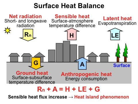
12 Net radiation Rn Sensible heat H Latent heat LE Storage W/mheat 2 DG W/m W/m 2 Heat Island Analysis by ASTER, Formosat-2 and a ground-based sensor W/m 2
13 We need international standard to Quickly discover sensors and sensor data (secure or public) that can meet my needs location, observables, quality, ability to task Obtain sensor information in a standard encoding that is understandable by me and my software Readily access sensor observations in a common manner, and in a form specific to my needs Task sensors, when possible, to meet my specific needs Subscribe to and receive alerts or notification when a sensor measures a particular phenomenon, or completes a task

14 OGC Sensor Web Enablement Satellite-borne Imaging Device Traffic Monitoring Environmental Monitor Airborne Imaging Device Webcam Health Monitor Copyright 2007, Open Geospatial Consortium, Inc., All Rights Reserved.
15 Specifications for Sensor Web Enablement Web Services Sensor Observations Service (SOS) Standard web service interface for requesting, filtering, and retrieving observations and sensor system information Sensor Planning Service (SPS) Standard web service interface for requesting userdriven acquisitions and observations Sensor Alert Service (SAS) Standard web service interface for publishing and subscribing to alerts from sensors Web Notification Services (WNS) Standard web service interface for asynchronous delivery of messages or alerts from SAS and SPS web services and other elements of service workflows
16 Specifications for Sensor Web Enablement Information Models and Schema Observations & Measurements (O&M) Standard models and XML Schema for encoding observations and measurements from a sensor, both archived and real-time Sensor Model Language (SensorML) Standard models and XML Schema for describing sensors systems and processes Transducer Model Language (TransducerML or TML) The conceptual model and XML Schema for describing transducers and supporting real-time streaming of data to and from sensor systems


17 Field Observation Network (FON) VO Satellite Data Calibration Auxiliary data Auxiliary data Auxiliary data Auxiliary data Validation Satellite Sensor Products Ground-based data Global products Global carbon cycle Climate change predictions Evaluation of global warming etc


")


18 Atmospheric Parameters Ground physical parameters Atmosphere Ground Satellite sensor products Data View Service Sensor Observation Service (SOS) Search results Observation Period Station ID Atmospheric parameters Sensor name Users Satellite Sensors Field Sensors
19 Future work Launch FON VO (very shortly) Workflow with WPS (Web Processing Service) International/Domestic collaboration (e.g., PRAGMA) More applications Bridging GRID (OGF) and GIS (OGC) communities
Copernicus Overview. Major Emergency Management Conference Athlone 2017
 Copernicus Overview Major Emergency Management Conference Athlone 2017 Copernicus is a European programme implemented by the European Commission. The services address six thematic areas: land, marine,
Development of High Performance Computing and the Japanese Planning. Satoshi Sekiguchi (AIST, Japan)
") 1 Development of High Performance Computing and the Japanese Planning Satoshi Sekiguchi (AIST, Japan) 2 1. High Performance Computing Infrastructure in Japan 2. HPC for Societal Benefit Area (ex. GEO Grid)
1 Development of High Performance Computing and the Japanese Planning Satoshi Sekiguchi (AIST, Japan) 2 1. High Performance Computing Infrastructure in Japan 2. HPC for Societal Benefit Area (ex. GEO Grid)
Roadmap to interoperability of geoinformation
 Roadmap to interoperability of geoinformation and services in Europe Paul Smits, Alessandro Annoni European Commission Joint Research Centre Institute for Environment and Sustainability paul.smits@jrc.it
USING GIS CARTOGRAPHIC MODELING TO ANALYSIS SPATIAL DISTRIBUTION OF LANDSLIDE SENSITIVE AREAS IN YANGMINGSHAN NATIONAL PARK, TAIWAN
 CO-145 USING GIS CARTOGRAPHIC MODELING TO ANALYSIS SPATIAL DISTRIBUTION OF LANDSLIDE SENSITIVE AREAS IN YANGMINGSHAN NATIONAL PARK, TAIWAN DING Y.C. Chinese Culture University., TAIPEI, TAIWAN, PROVINCE
Imagery and the Location-enabled Platform in State and Local Government
 Imagery and the Location-enabled Platform in State and Local Government Fred Limp, Director, CAST Jim Farley, Vice President, Leica Geosystems Oracle Spatial Users Group Denver, March 10, 2005 TM TM Discussion
Time Series Analysis with SAR & Optical Satellite Data
 Time Series Analysis with SAR & Optical Satellite Data Thomas Bahr ESRI European User Conference Thursday October 2015 harris.com Motivation Changes in land surface characteristics mirror a multitude of
3-04 東 東南アジアの地質情報総合データベースの構築 : CCOP 地質情報総合共有プロジェクト
 3-04 東 東南アジアの地質情報総合データベースの構築 : CCOP 地質情報総合共有プロジェクト 宝田晋治 1 Joel Bandibas 1 Constructing a comprehensive geoscience database in East and Southeast Asia: CCOP Geoinformation Sharing Infrastructure for East
OGC and GSDI: A Partnership in Advancing SDI Best Practices
 OGC and GSDI: A Partnership in Advancing SDI Best Practices GSDI 11 Workshop 1.4 SDI Challenges 15 June 2009 Mark Reichardt President and CEO mreichardt@opengeospatial.org +1 301 840-1361 Copyright 2009,
SDI and Beyond The Importance of Standards and Interoperability For Good Governance; Selected Examples
 SDI and Beyond The Importance of Standards and Interoperability For Good Governance; Selected Examples Trevor Taylor, Director, Member Services, Asia and the Americas Sao Paulo May 7 th, 2014 Why is Geospatial
I&CLC2000 in support to new policy initiatives (INSPIRE, GMES,..)
") I&CLC2000 in support to new policy initiatives (INSPIRE, GMES,..) Manfred Grasserbauer, Director Joint Research Centre Institute for Environment and Sustainability 1 IMAGE 2000 European mosaic of satellite
I&CLC2000 in support to new policy initiatives (INSPIRE, GMES,..) Manfred Grasserbauer, Director Joint Research Centre Institute for Environment and Sustainability 1 IMAGE 2000 European mosaic of satellite
U s i n g t h e E S A / E U M E T C A S T N a v i g a t o r s
 U s i n g t h e E S A / E U M E T C A S T N a v i g a t o r s Copernicus User Uptake Information Sessions Copernicus EU Copernicus EU Copernicus EU www.copernicus.eu I N T R O D U C T I O N O F U S E C
Sentinel Asia Tsunami Working Group
 Sentinel Asia Tsunami Working Group Co-Chairman: Prof. Shunichi Koshimura Abdul Muhari, PhD 4 th Joint Project Team Meeting (JPTM 2017): Sentinel Asia STEP 3 Abdul MUHARI, PhD Ministry of Marine Affairs
GIS-based Smart Campus System using 3D Modeling
 GIS-based Smart Campus System using 3D Modeling Smita Sengupta GISE Advance Research Lab. IIT Bombay, Powai Mumbai 400 076, India smitas@cse.iitb.ac.in Concept of Smart Campus System Overview of IITB Campus
You are Building Your Organization s Geographic Knowledge
 You are Building Your Organization s Geographic Knowledge And Increasingly Making it Available Sharing Data Publishing Maps and Geo-Apps Developing Collaborative Approaches Citizens Knowledge Workers Analysts
Applied Geoscience and Technology Division SOPAC. Joy Papao, Risk Information Systems Officer
 Joy Papao, Risk Information Systems Officer Secretariat of the Pacific Community SPC 22 Pacific Island States Head office in Noumea, New Caledonia 2 Regional offices (Pohnpei and Honiara) 600 staff 9 Technical
What is CERA? Coastal Emergency Risks Assessment
 What is CERA? Coastal Emergency Risks Assessment Visualization tool using OGC standards Displays the outputs from the ADCIRC storm surge model or other coastal models Represents the maps on interactive
The EOC Geoservice: Standardized Access to Earth Observation Data Sets and Value Added Products
 The EOC Geoservice: Standardized Access to Earth Observation Data Sets and Value Added Products Klaus Dengler, Torsten Heinen, Albert Huber, Katrin Molch, Eberhard Mikusch DLR German Remote Sensing Data
Methodological Chain for Hydrological Management with Web-GIS Applications
 Advances in Geosciences Konstantinos Perakis & Athanasios Moysiadis, Editors EARSeL, 2012 Methodological Chain for Hydrological Management with Web-GIS Applications Alexandros Konstantinidis 1, Eleni Tzanou
Pushing the Standards Edge: Collaborative Testbeds to Accelerate Standards Development and Implementation
 Pushing the Standards Edge: Collaborative Testbeds to Accelerate Standards Development and Implementation Mark E. Reichardt President mreichardt@opengeospatial.org 31 October 2006 2006 Open Geospatial
Applications: Introduction Task 1: Introduction to ArcCatalog Task 2: Introduction to ArcMap Challenge Question References
 CHAPTER 1 INTRODUCTION 1.1 GIS? 1.1.1 Components of a GIS 1.1.2 A Brief History of GIS 1.1.3 GIS Software Products Box 1.1 A List of GIS Software Producers and Their Main Products 1.2 GIS Applications
GIS and Remote Sensing
 Spring School Land use and the vulnerability of socio-ecosystems to climate change: remote sensing and modelling techniques GIS and Remote Sensing Katerina Tzavella Project Researcher PhD candidate Technology
Content. Geospatial Database for the GeoDRM System
 Technical Advisory Mission September 2013, Cook Islands Geospatial Database for the GeoDRM System Nitin Kumar Tripathi, PhD IDD Consultant, ESCAP Coordinator, Remote Sensing and GIS FoS, Asian Institute
Regional EGM on Community of Practice of Georeferenced Information System. for Disaster Risk Management (Geo-DRM) April 2014, Bangkok, Thailand
 April 2014, Bangkok, Thailand") Regional EGM on Community of Practice of Georeferenced Information System for Disaster Risk Management (Geo-DRM) 23-25 April 2014, Bangkok, Thailand Presented By Mukesh Kumar Keshari Ministry of Home Affairs
Regional EGM on Community of Practice of Georeferenced Information System for Disaster Risk Management (Geo-DRM) 23-25 April 2014, Bangkok, Thailand Presented By Mukesh Kumar Keshari Ministry of Home Affairs
Humanitarian Assistance and Disaster Relief (HADR)
") Humanitarian Assistance and Disaster Relief (HADR) Remote sensing, GIS & Server Technology for Planning, Response & Mitigation Jonathan Lee Hon Yip Senior Technical Sales, Intergraph Security, Government
Humanitarian Assistance and Disaster Relief (HADR) Remote sensing, GIS & Server Technology for Planning, Response & Mitigation Jonathan Lee Hon Yip Senior Technical Sales, Intergraph Security, Government
INSPIREd solutions for Air Quality problems Alexander Kotsev
 INSPIREd solutions for Air Quality problems Alexander Kotsev www.jrc.ec.europa.eu Serving society Stimulating innovation Supporting legislation The European data puzzle The European data puzzle 24 official
Georeferencing and Satellite Image Support: Lessons learned, Challenges and Opportunities
 Georeferencing and Satellite Image Support: Lessons learned, Challenges and Opportunities Shirish Ravan shirish.ravan@unoosa.org UN-SPIDER United Nations Office for Outer Space Affairs (UNOOSA) UN-SPIDER
GEOMATICS. Shaping our world. A company of
 GEOMATICS Shaping our world A company of OUR EXPERTISE Geomatics Geomatics plays a mayor role in hydropower, land and water resources, urban development, transport & mobility, renewable energy, and infrastructure
Land Cover Classification Mapping & its uses for Planning
 Land Cover Classification Mapping & its uses for Planning What is Land Cover Classification Mapping? Examples of an actual product Why use Land Cover Classification Mapping for planning? Possible uses
Mark E Reichardt. President & CEO Open Geospatial Consortium
 Mark E Reichardt President & CEO Open Geospatial Consortium mreichardt@myogc.org Agenda 0900-0915 Welcome and Introduction - Topic setting (Chair) 0915-0935 Ron Bloksma, The next step is interoperability
Spatial Data Infrastructure Concepts and Components. Douglas Nebert U.S. Federal Geographic Data Committee Secretariat
 Spatial Data Infrastructure Concepts and Components Douglas Nebert U.S. Federal Geographic Data Committee Secretariat August 2009 What is a Spatial Data Infrastructure (SDI)? The SDI provides a basis for
AND THE COOPERATION WITH SENTINEL ASIA FOR DISASTER MANAGEMENT
 Ministry of Natural resources and Environment National Remote Sensing DEpartment NATIONAL REMOTE SENSING DEPARTMENT (NRSD) AND THE COOPERATION WITH SENTINEL ASIA FOR DISASTER MANAGEMENT By: Dr. Chu Hai
Editorial Introduction: Special Issue on Grids and Geospatial Information Systems
 EditorialIntroduction:SpecialIssueonGridsand GeospatialInformationSystems MarlonE.Pierce CommunityGridsLaboratory IndianaUniversity mpierce@cs.indiana.edu Abstract: Grids and Geospatial Information Systems(GIS)
Launch of Data Collection or Production Centre for World Weather Information Service
 Launch of Data Collection or Production Centre for World Weather Information Service The Hong Kong Observatory (HKO) announces that the Data Collection or Production Centre (DCPC) for the World Weather
Data Origin. Ron van Lammeren CGI-GIRS 0910
 Data Origin Ron van Lammeren CGI-GIRS 0910 How to obtain geodata? Geo data initiative Executive Order 12906, "Coordinating Geographic Data Acquisition and Access: The National Spatial Data Infrastructure,"
National Satellite Data Centre and Finnish Sentinel Collaborative Ground Segment. Jyri Heilimo Finnish Meteorological Instute
 National Satellite Data Centre and Finnish Sentinel Collaborative Ground Segment Jyri Heilimo Finnish Meteorological Instute Sodankylä National Satellite Data Centre National satellite data centre providing
GeoWorlds: Integrated Digital Libraries and Geographic Information Systems
 GeoWorlds: Integrated Digital Libraries and Geographic Information Systems http://www.isi.edu/geoworlds Robert Neches In-Young Ko, Robert MacGregor, Ke-Thia Yao Distributed Scalable Systems Division USC
Data Aggregation with InfraWorks and ArcGIS for Visualization, Analysis, and Planning
 Data Aggregation with InfraWorks and ArcGIS for Visualization, Analysis, and Planning Stephen Brockwell President, Brockwell IT Consulting, Inc. Join the conversation #AU2017 KEYWORD Class Summary Silos
Part : General Situation of Surveying and Mapping. The Development of Surveying and Mapping in China. The contents
 The Development of Surveying and Mapping in China Dr. Ping Xiao China.P.R The contents Part : General Situation of Surveying and Mapping 1. The legal systems of surveying and mapping 2. The technologies
Data Origin. How to obtain geodata? Ron van Lammeren CGI-GIRS 0910
 Data Origin How to obtain geodata? Ron van Lammeren CGI-GIRS 0910 Spatial Data interest Improvement of policy making. ± 90% of all information used by government has spatial characteristics SPATIAL INFORMATION
ArcGIS is Advancing. Both Contributing and Integrating many new Innovations. IoT. Smart Mapping. Smart Devices Advanced Analytics
 ArcGIS is Advancing IoT Smart Devices Advanced Analytics Smart Mapping Real-Time Faster Computing Web Services Crowdsourcing Sensor Networks Both Contributing and Integrating many new Innovations ArcGIS
DEVELOPMENT OF OGC FRAMEWORK FOR ESTIMATING AIR TEMPERATURE FROM MODIS LST AND SENSOR NETWORK
 DEVELOPMENT OF OGC FRAMEWORK FOR ESTIMATING AIR TEMPERATURE FROM MODIS LST AND SENSOR NETWORK S. Ninsawat a, H. Yamamoto a, R. Nakamura a, A. Kamei a, S. X. Kato b and S. Tsuchida a a National Institute
Regional Flash Flood Guidance and Early Warning System
 WMO Training for Trainers Workshop on Integrated approach to flash flood and flood risk management 24-28 October 2010 Kathmandu, Nepal Regional Flash Flood Guidance and Early Warning System Dr. W. E. Grabs
Effective Utilization of Synthetic Aperture Radar (SAR) Imagery in Rapid Damage Assessment
 Imagery in Rapid Damage Assessment") Effective Utilization of Synthetic Aperture Radar (SAR) Imagery in Rapid Damage Assessment Case Study Pakistan Floods SUPARCO M. Maisam Raza, Ahmad H. Rabbani SEQUENCE Flood Monitoring using Satellite
Effective Utilization of Synthetic Aperture Radar (SAR) Imagery in Rapid Damage Assessment Case Study Pakistan Floods SUPARCO M. Maisam Raza, Ahmad H. Rabbani SEQUENCE Flood Monitoring using Satellite
IGOS Geohazards: toward an improved use of Earth Observations for Geohazards mitigation
 IGOS Geohazards: toward an improved use of Earth Observations for Geohazards mitigation Scientific and Technical Subcommittee session Vienna, 15th February 2007 Gonéri Le Cozannet IGOS Geohazards Bureau
Green Space Services for Local Monitoring
 Green Space Services for Local Monitoring Aratos Group V3.0 2016/08 Value added services for the society using space and satellite technologies Aratos Group 2 One of the first European downstream value
March 2007 The Survey Department of Sri Lanka
 Contribution of Survey Department of Sri Lanka for Mitigation of Disasters in Sri Lanka K.A.U.N.Kasthuri Deputy Surveyor General (Information Technology) March 2007 The Survey Department of Sri Lanka 1
Introduction to GIS Suchith Anand
 Introduction to GIS Suchith Anand Introduction What is GIS? Spatial Data Models Fundamental GIS Map generalization Applied GIS Future Study links What is a Map? A map is a visual representation of an area
Building a 4-D Weather Data Cube for the NextGen Initial Operating Capability (IOC)
") Building a 4-D Weather Data Cube for the NextGen Initial Operating Capability (IOC) Friends/Partners in Aviation Weather Vision Forum July 15, 2008 Bruce Lambert - DoD Tom Ryan FAA Jason Tuell NWS 1 Overview
Building a 4-D Weather Data Cube for the NextGen Initial Operating Capability (IOC) Friends/Partners in Aviation Weather Vision Forum July 15, 2008 Bruce Lambert - DoD Tom Ryan FAA Jason Tuell NWS 1 Overview
SDI Standards at work
 SDI Standards at work Jan Juul Jensen Senior Technology Strategist Informi GIS Denmark Informi GIS Private held Limited Company Specialized in GIS 100+ employees HQ in Charlottenlund, Copenhagen Regional
Visualizing Uncertainty In Environmental Work-flows And Sensor Streams
 Visualizing Uncertainty In Environmental Work-flows And Sensor Streams Karthikeyan Bollu Ganesh and Patrick Maué Institute for Geoinformatics (IFGI), University of Muenster, D-48151 Muenster, Germany {karthikeyan,pajoma}@uni-muenster.de
Implementing an online spatial database using the GRASS GIS environment
 Proceedings of the Open source GIS - GRASS users conference 2002 - Trento, Italy, 11-13 September 2002 Implementing an online spatial database using the GRASS GIS environment Venkatesh Raghavan*, Shinji
Atmospheric Science and GIS Interoperability issues: some Data Model and Computational Interface aspects
 UNIDATA Boulder, Sep. 2003 Atmospheric Science and GIS Interoperability issues: some Data and Computational Interface aspects Stefano Nativi University of Florence and IMAA-CNR Outline Service-Oriented
Copernicus EMS: Αξιολόγηση πολλαπλών φυσικών κινδύνων - Σχεδιασμός και Ανάκτηση
 Building Capacity for a Centre of Excellence for EO-based monitoring of Natural Disasters Copernicus EMS: Αξιολόγηση πολλαπλών φυσικών κινδύνων - Σχεδιασμός και Ανάκτηση Γιάννης Παπουτσής ΙΑΑΔΕΤ Εθνικό
GIS GIS.
 GIS 388 Vol., No.3, Autumn 2009 99-4 GIS Iranian Remote Sensing & GIS 2 * (GIS). GIS.2 389/5/6 : 389/2/6 :........ : 8878622 : GIS ( ) : * Email: PouriaAmirian@gmail.com ... (AQI) 2.(Cheng et al., 2007)..
ArcGIS for INSPIRE. Marten Hogeweg Satish Sankaran
 ArcGIS for INSPIRE Marten Hogeweg Satish Sankaran Outline What is ArcGIS ArcGIS for INSPIRE Web GIS Case Studies Roadmap Q&A What is INSPIRE? INSPIRE is the legal framework for a European Spatial Data
Graduate Courses Meteorology / Atmospheric Science UNC Charlotte
 Graduate Courses Meteorology / Atmospheric Science UNC Charlotte In order to inform prospective M.S. Earth Science students as to what graduate-level courses are offered across the broad disciplines of
Regional Report. Asia
 OneGeology Board Meeting #15, Vancouver, Canada, 14 June 2018 Regional Report Asia Masahiko Makino Geological Survey of Japan, AIST OneGeology Board Meeting #15, Vancouver, Canada, 14-15 June 2018 Contents
INTRODUCTION TO OGC S SENSORML AND O&M: EXAMPLE OF A POSSIBLE SOLUTION
 INTRODUCTION TO OGC S SENSORML AND O&M: EXAMPLE OF A POSSIBLE SOLUTION Alessandro Oggioni & Holger Dettki A future for a common bio-logging language? BLS 6, 27 September 2017, Konstanz, Germany OPEN GEOSPATIAL
REVIEW MAPWORK EXAM QUESTIONS 31 JULY 2014
 REVIEW MAPWORK EXAM QUESTIONS 31 JULY 2014 Lesson Description In this lesson we: Focus on key concepts and exam questions relating to GIS. Question 1 Test Yourself The most important component of a GIS
GIS in Weather and Society
 GIS in Weather and Society Olga Wilhelmi Institute for the Study of Society and Environment National Center for Atmospheric Research WAS*IS November 8, 2005 Boulder, Colorado Presentation Outline GIS basic
STANDARD OPERATING PROCEDURES
 PAGE: 1 of 5 CONTENTS 1.0 SCOPE AND APPLICATION 2.0 METHOD SUMMARY 3.0 SAMPLE PRESERVATION, CONTAINERS, HANDLING, AND STORAGE 4.0 INTERFERENCE AND POTENTIAL PROBLEMS 5.0 EQUIPMENT/APPARATUS 6.0 REAGENTS
(2008) 8 (6) ISSN
 8 (6) ISSN") Le Cozannet, Gonéri and Hosford, Steven and Douglas, John and Serrano, Jean-Jacques and Coraboeuf, Damien and Comte, Jérémie (2008) Connecting hazard analysts and risk managers to sensor information. Sensors,
Le Cozannet, Gonéri and Hosford, Steven and Douglas, John and Serrano, Jean-Jacques and Coraboeuf, Damien and Comte, Jérémie (2008) Connecting hazard analysts and risk managers to sensor information. Sensors,
Observatories in the context of the Digital Continent: CZO s and HIS
 Observatories in the context of the Digital Continent: CZO s and HIS Dr. Richard P. Hooper, President, Consortium of Universities for the Advancement of Hydrologic Science, Inc. Why Observatories? From
Utilization of Global Map for Societal Benefit Areas
 Utilization of Global Map for Societal Benefit Areas The Fourth GEOSS AP Symposium Bali Indonesia, 11th March 2010 Shuhei Kojima Geographical Survey Institute Ministry of Land, Infrastructure, Transport
LandEx A GeoWeb-based Tool for Exploration of Patterns in Raster Maps
 LandEx A GeoWeb-based Tool for Exploration of Patterns in Raster Maps T. F. Stepinski 1, P. Netzel 1,2, J. Jasiewicz 3, J. Niesterowicz 1 1 Department of Geography, University of Cincinnati, Cincinnati,
Remote Sensing. RS Study in RS&GIS FoS
 AT 76.03 Remote Sensing Prof. Kiyoshi Honda, Chubu University Dr. Nobuya Watanabe, Chubu University Supported by Japanese Government s Short Time Visiting Faculty Scheme RS&GIS School of Engineering and
Geometric Algorithms in GIS
 Geometric Algorithms in GIS GIS Visualization Software Dr. M. Gavrilova GIS Software for Visualization ArcView GEO/SQL Digital Atmosphere AutoDesk Visual_Data GeoMedia GeoExpress CAVE? Visualization in
Open Data meets Big Data
 Open Data meets Big Data Max Craglia, Sven Schade, Anders Friis European Commission Joint Research Centre www.jrc.ec.europa.eu Serving society Stimulating innovation Supporting legislation JRC is Technical
Introduction of the Asia-Oceania Global Earth Observation System of Systems (AOGEOSS) GEO Initiative(GI-22 )
 GEO Initiative(GI-22 )") Introduction of the Asia-Oceania Global Earth Observation System of Systems (AOGEOSS) GEO Initiative(GI-22 ) Prof. Xiang ZHOU Institute of Remote Sensing and Digital Earth, CAS 11 May 2017 Kunming, China
Introduction of the Asia-Oceania Global Earth Observation System of Systems (AOGEOSS) GEO Initiative(GI-22 ) Prof. Xiang ZHOU Institute of Remote Sensing and Digital Earth, CAS 11 May 2017 Kunming, China
Overview. Everywhere. Over everything.
 Cadenza Desktop Cadenza Web Cadenza Mobile Cadenza Overview. Everywhere. Over everything. The ultimate GIS and reporting suite. Provide, analyze and report data efficiently. For desktop, web and mobile.
One platform for desktop, web and mobile
 One platform for desktop, web and mobile Search and filter Get access to all data thematically filter data in context factually and spatially as well as display it dynamically. Export a selection or send
SPATIAL INFORMATION GRID AND ITS APPLICATION IN GEOLOGICAL SURVEY
 SPATIAL INFORMATION GRID AND ITS APPLICATION IN GEOLOGICAL SURVEY K. T. He a, b, Y. Tang a, W. X. Yu a a School of Electronic Science and Engineering, National University of Defense Technology, Changsha,
Advanced Image Analysis in Disaster Response
 Advanced Image Analysis in Disaster Response Creating Geographic Knowledge Thomas Harris ITT The information contained in this document pertains to software products and services that are subject to the
StreamStats: Delivering Streamflow Information to the Public. By Kernell Ries
 StreamStats: Delivering Streamflow Information to the Public By Kernell Ries U.S. Department of the Interior U.S. Geological Survey MD-DE-DC District 410-238-4317 kries@usgs.gov StreamStats Web Application
GIS at UCAR. The evolution of NCAR s GIS Initiative. Olga Wilhelmi ESIG-NCAR Unidata Workshop 24 June, 2003
 GIS at UCAR The evolution of NCAR s GIS Initiative Olga Wilhelmi ESIG-NCAR Unidata Workshop 24 June, 2003 Why GIS? z z z z More questions about various climatological, meteorological, hydrological and
NGIAs' roles in successful disaster response
 The Second UN-GGIM-AP Plenary Meeting NGIAs' roles in successful disaster response Japan Teheran Iran 28 October 2013 Shin-ichi SAKABE, Director of International Affairs Division Geospatial Information
ISO/TR TECHNICAL REPORT. Geographic information Imagery and gridded data. Information géographique Imagerie et données quadrillées
 TECHNICAL REPORT ISO/TR 19121 First edition 2000-10-15 Geographic information Imagery and gridded data Information géographique Imagerie et données quadrillées Reference number ISO/TR 19121:2000(E) ISO
OGC Standards Update 29 November 2018 Orlando
 OGC Standards Update 29 November 2018 Orlando Mark Reichardt mreichardt@opengeospatial.org +1 301 840-1361 OGC S INTEREST It s simple You have this or this and you need to make this... or this Courtesy
THE ESTABLISHMENT OF DIGITAL HIGH RESOLUTION GEODATABASES FOR WEBGIS: FROM DIGITAL CAMPUS TO DIGITAL NATIONAL PARK
 THE ESTABLISHMENT OF DIGITAL HIGH RESOLUTION GEODATABASES FOR WEBGIS: FROM DIGITAL CAMPUS TO DIGITAL NATIONAL PARK Y. C. Ding a, *, C. C. Huang a a Digital Earth Research Center (DERC), Chinese Culture
Disaster Management in Republic of Korea
 The Third UN-GGIM-AP Plenary Meeting Disaster Management in Republic of Korea ~Coordination among NGIA & Other Related Organizations and Recommendations~ Bali Indonesia 10 November 2014 Sanghoon Lee, Ph.D.
Bentley Map Advancing GIS for the World s Infrastructure
 Bentley Map Advancing GIS for the World s Infrastructure Presentation Overview Why would you need Bentley Map? What is Bentley Map? Where is Bentley Map Used? Why would you need Bentley Map? Because your
Country Report Nepal Geospatial Data Sharing Initiatives of Survey Department Supporting Disaster Management
 Third JPTM Step 2 for Sentinel Asia 6-8 July, 2010 Manila, The Philippines Country Report Nepal Geospatial Data Sharing Initiatives of Survey Department Supporting Disaster Management Durgendra M Kayastha
L i n k i n g f l o o d i m p a c t f o r e c a s t i n g a n d s a t e l l i t e r a p i d m a p p i n g i n E u r o p e
 L i n k i n g f l o o d i m p a c t f o r e c a s t i n g a n d s a t e l l i t e r a p i d m a p p i n g i n E u r o p e Francesco Dottori, Milan Kalas, Peter Salamon, Annett Wania, Ines Rivero (EC JRC)
SUPPORTS SUSTAINABLE GROWTH
 DDSS BBUUN NDDLLEE G E O S P AT I A L G O V E R N A N C E P A C K A G E SUPPORTS SUSTAINABLE GROWTH www.digitalglobe.com BRISBANE, AUSTRALIA WORLDVIEW-3 30 CM International Civil Government Programs US
INSPIRing Geospatial Framework For Local Administrations
 This project is financed by the European Union and the Republic of Turkey Presented at the FIG Congress 2018, May 6-11, 2018 in Istanbul, Turkey National Programme for Turkey 2010 Instrument for Pre-Accession
BIM and INSPIRE, for a better integration of built infrastructures in their environment : the MINnD project
 BIM and INSPIRE, for a better integration of built infrastructures in their environment : the MINnD project François ROBIDA Christophe CASTAING Strasbourg, > 1 8 septembre 2017 ABOUT BIM Building Information
Geospatial natural disaster management
 Geospatial natural disaster management disasters happen. are you ready? Natural disasters can strike almost anywhere at any time, with no regard to a municipality s financial resources. These extraordinarily
Introduction to Field Data Collection
 Introduction to Field Data Collection Dr. Yuji Murayama (Professor) Dr. Ko Ko Lwin (JSPS Postdoctoral Researcher) Division of Spatial Information Science Graduate School of Life and Environmental Sciences
GIS and Remote Sensing Support for Evacuation Analysis
 GIS and Remote Sensing Support for Evacuation Analysis Presented to GIS for Transportation Symposium Rapid City, South Dakota March 28-31, 2004 Demin Xiong Oak Ridge National Laboratory 2360 Cherahala
Spatial Statistical Information Services in KOSTAT
 Distr. GENERAL WP.30 12 April 2010 ENGLISH ONLY UNITED NATIONS ECONOMIC COMMISSION FOR EUROPE (UNECE) CONFERENCE OF EUROPEAN STATISTICIANS EUROPEAN COMMISSION STATISTICAL OFFICE OF THE EUROPEAN UNION (EUROSTAT)
Discovery and Access to Global Water Data, Maps and Services
 Discovery and Access to Global Water Data, Maps and Services David K. Arctur, PhD david.arctur@utexas.edu University of Texas at Austin Open Geospatial Consortium (OGC) Esri International User Conference
ISO INTERNATIONAL STANDARD. Geographic information Metadata Part 2: Extensions for imagery and gridded data
 INTERNATIONAL STANDARD ISO 19115-2 First edition 2009-02-15 Geographic information Metadata Part 2: Extensions for imagery and gridded data Information géographique Métadonnées Partie 2: Extensions pour
GenEd Courses offered by Dept. of Geography, Presidency University
 GenEd Courses offered by Dept. of Geography, Presidency University (All the Courses are offered to both Science and Humanities Students) Semester Course No. Course Name Maximum No. of Students (originally
Geospatial SDI Portal for effective Governance of Pune METROPOLIS region
 Geospatial SDI Portal for effective Governance of Pune METROPOLIS region Mr. Praveen Gautam Senior Manager 19 th January 2018 PMRDA Overview Provide a Spatial Framework for the entire region with various
NCC roles in successful disaster response I.R.IRAN
 The Second UN-GGIM-AP Plenary Meeting NCC roles in successful disaster response I.R.IRAN Teheran Iran 28-30 October 2013 Ali Javidaneh Technical Deputy of National Cartographic Center (NCC) Outline Types
gvsig a real tool for GIS technicians
 gvsig a real tool for GIS technicians Jorge Gaspar Sanz Salinas jsanz@prodevelop.es International Geodetic Students Meeting 05/05/08 Valencia Agenda of the project OK, but what can gvsig do for me now?
Cutting Edge Engineering for Modern Geospatial Systems Rear Admiral Dr. S Kulshrestha, retd
 Cutting Edge Engineering for Modern Geospatial Systems Rear Admiral Dr. S Kulshrestha, retd 11 Jun 2015 GeoIntelligence Asia 2015 The technology would become so pervasive that it becomes a part of you
Australian Earth Science Research Spatial Information Infrastructure
 AN ORGANISATION FOR A NATIONAL EARTH SCIENCE INFRASTRUCTURE PROGRAM Australian Earth Science Research Spatial Information Infrastructure Dr Robert Woodcock AuScope Grid - Director Outline Why build an
GSCB Workshop 2009: EUMETSAT Missions
 GSCB Workshop 2009: EUMETSAT Missions Dr. Harald Rothfuss, EUMETSAT. GSCB Workshop 2007, ESRIN, Frascati, 18-19 June 2009. Slide: 1 Introduction To EUMETSAT The European Organisation for the Exploitation
METRIC tm. Mapping Evapotranspiration at high Resolution with Internalized Calibration. Shifa Dinesh
 METRIC tm Mapping Evapotranspiration at high Resolution with Internalized Calibration Shifa Dinesh Outline Introduction Background of METRIC tm Surface Energy Balance Image Processing Estimation of Energy