Copernicus Information & Training Session
|
|
|
- Rosanna Dalton
- 6 years ago
- Views:
Transcription
1 Copernicus Information & Training Session Copernicus Emergency Management Service Dora Aifantopoulou GEOAPIKONISIS S.A.P.GE. Copernicus EU Copernicus EU Copernicus EU Athens
2 Outline of the Presentation EMS Service Overview Copernicus EMS Mapping Rapid Mapping Domain Risk & Recovery Domain Copernicus EMS Early Warning EFAS Actors & Services EFFIS Actors & Services Athens
0312-2013/0164(COD)] EMS implementation: separate service modules EMS Mapping EMS Early warning Emergency Mapping Validation EMS")
3 Service & Overview Emergency Management Service EMS COPERNICUS service; Atmosphere, Marine, Land & Climate Change monitoring, Emergency Management & Security Operational since April 2012 Continuation: full operational service [Copernicus Regulation OM(2013) /0164(COD)] EMS implementation: separate service modules EMS Mapping EMS Early warning Emergency Mapping Validation EMS Coordination Overall Coordination Financial / Political DG ENTR Operational Coordination Users & European External Action Service Authorizing the activations DG ECHO DG JRC Technical coordination of the activities Management of contracts Monitoring the Activations Technical support to Commission services Athens


4 EMS Mapping - Application Domain 1 / 2 COPERNICUS EMS - Mapping Worldwide coverage Satellite imagery is used as the main data source Wide range of Emergency Situations resulting from natural or man-made disasters Meteorological Hazards Geophysical Hazards Deliberate & Accidental Disasters Humanitarian Disasters Floods Tsunamis Severe Storms Earthquakes Volcanic Eruptions Landslides Technological Disasters Fires Humanitarian Crises Support Emergency management - Response activities immediately following an emergency event Recovery, Reconstruction, disaster Risk Reduction, Preparedness & Prevention Rapid Mapping Risk & Recovery Mapping Athens
 European Flood Awareness System - EFAS European Forest Fire Information System - EFFIS Athens 07.10.2016 5")
5 EMS Mapping - Application Domain 2/ 2 COPERNICUS EMS Early Warning European coverage monitoring and forecasts (10/ 6 days) European Flood Awareness System - EFAS European Forest Fire Information System - EFFIS Athens
6 Copernicus Information & Training Session Copernicus EMS Mapping Copernicus EU Copernicus EU Copernicus EU Athens


7 EMS Mapping - Actors Authorized Users ping/list-of-components/emsr180 Civil Protection Authorities Other National Focal Points echo-ercc@ec.europa.eu Emergency Response Coordination Centre 24/7 DG JRC Technical Supervision Quality Specifications - Timeliness Data / Services Providers European Space Agency Prompt Support EO Data Provision Athens
8 EMS Mapping - Who can Use the Service Authorized Users Service Trigger Service Request Form (SRF) directly to the European Response Coordination Centre (ERCC) National Focal Points (NFPs); EU Member States & countries participating in the European Civil Protection Mechanism EC Services (DGs) and Associated Users Service Trigger Situation Room of the European External Action Service Through the Authorized Users Local, Regional and Other public entities International Governmental Organisations National & International Non-Governmental Organisations Entities and Institutions within the EEAS sphere; EU Delegations, INTCEN, EU Satellite Centre General Public Users No Service Trigger Information of activation requests through the web portal Athens


9 EMS Mapping - Service Request Service Request Form/ SRF Disaster Date/ Area Information Content Scale/ Format Athens
10 EMS Mapping - Acts & Facts Uninterrupted Service (almost five years) On-demand and fast provision (within hours or days) of geospatial information RM - within hours or (few) days RRM - within twenty days (after delivery of EO data): Accurate Analysis & Modelling Worldwide Coverage More than 40 worldwide Users organizations More than 50 different Countries Intensive Production Thousands ( ~ ) of maps delivered to the Users (2.000 RM / RRM) More than 200 activations (185 RM / 35 RRM) Athens

11 EMS Mapping - Thematic Products THEMATIC MAPS - Standardized format Map Title Information content/ Location/ date Map Index Cartographic Information Scale/ Projection System Map Legend Statistical Information Areas, Assets, etc Users/ Usage Information Data Sources Satellite/ Other Publication/ Framework Methodological Approach GEO INFORMATION LAYERS & DATA BASES TECHNICAL INFORMATION REPORT S & METADATA Athens


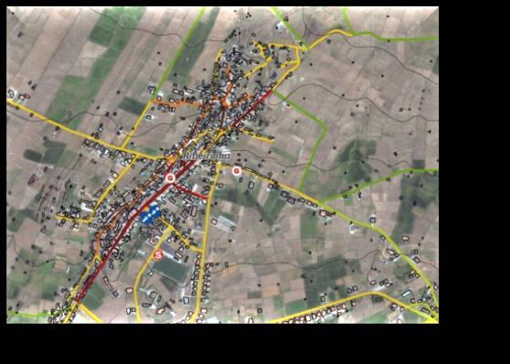
12 Rapid Mapping activations as per September 2016 Copernicus Emergency Management Service EMS Mapping - Provided Services/ Products 1 / 9 RAPID MAPPING 3% 5% On-demand and Fast provision (hours-days) of geospatial information 2% 20% 12% Two Service Levels 9% 9% 39% SL1 : 9 h to 12 h after the imagery delivery & quality approval SL5 : within 5 working days EARTHQUAKE FIRE FLOOD WIND STORM OTHER - landslides OTHER - volcano OTHER - humanitarian Three Types of Products Athens


13 EMS Mapping - Provided Services/ Products 2 / 9 Reference Maps RAPID MAPPING Updated knowledge on the territory and assets affected area Data prior to the disaster; pre-event image captured as close as possible prior to the event Content: topographic features, exposed assets, other available information EMSR185_11JEREMIE_REFERENCE_OVERVIEW_v1_300dpi.jpg Athens
 Derived from satellite post-disaster images.")

14 EMS Mapping - Provided Services/ Products 3 / 9 Delineation Maps RAPID MAPPING Assessment of the event extent (and of its evolution if requested) Derived from satellite post-disaster images. They vary depending on the disaster type and the delineation of the areas impacted by the disaster; burnt area, flooded area, earthquake impact area R180_01THASSOS_DELINEATION_OVERVIEW-MONIT01_v1_300dpi.jpg Athens


15 EMS Mapping - Provided Services/ Products 4 / 9 Grading Maps RAPID MAPPING Assessment of the damage grade (and of its evolution if requested): They include extent, magnitude or damage grades specific to each disaster type. Derived from satellite post-event images They may also provide relevant and up-to-date information, specific to affected population & assets SR175_01CALHETA_GRADING_OVERVIEW-MONIT02_v1_300dpi.jpg Athens
 RISK & RECOVERY MAPPING On-demand provision (month) of geospatial information Emergency management not related to the immediate response phase Prevention Preparedness")
16 R&R Mapping activations per year Copernicus Emergency Management Service EMS Mapping - Provided Services/ Products 5 / 9 EoI beginning 2016 Disaster management global stakeholders Civil Protection Members of NGO s (humanitarian) RISK & RECOVERY MAPPING On-demand provision (month) of geospatial information Emergency management not related to the immediate response phase Prevention Preparedness Disaster Risk Reduction Recovery Greece, Portugal, Spain, Poland Austria, Germany, Bulgaria, Hungary & DG JRC, DG ECHO Wide Variety of situations to be addressed Three Types of Products Athens


17 EMS Mapping - Provided Services/ Products 6 / 9 Reference Maps RISK & RECOVERY MAPPING Comprehensive and Updated knowledge on the territory and relevant assets Disaster Risk Reduction Context - Content: topographic features, assets, LU/LC, etc Athens
18 Copernicus Emergency Management Service EMS Mapping - Provided Services/ Products Pre-disaster situation Maps 7/9 RISK & RECOVERY MAPPING Relevant and up-to-date thematic information to assist / focus planning for contingencies on areas vulnerable to hazards, aiming to minimise loss of life and damage Hazard, Exposure, Vulnerability, Risk status, Evacuation plans, Modelling scenarios Hazard - UNISDR 2009 A dangerous phenomenon, substance, human activity or condition that may cause loss of life, injury or other health impacts, property damage, loss of livelihoods and services, social and economic disruption, or environmental damage. In technical settings, hazards are described quantitatively by the likely frequency of occurrence of different intensities for different areas, as determined from historical data or scientific analysis Exposure - UNISDR 2009 People, property, systems, or other elements present in hazard zones that are thereby subject to potential losses. it susceptible to the damaging effects of a hazard (distance with reference to Hazard zone & topography) Vulnerability - UNISDR 2009 The characteristics and circumstances of a community, system or asset that makes it susceptible to the damaging effects of a hazard (accounts for specific parameters with respect to the assets type) Risk - ISO Risk is the combination of the consequences of an event (hazard) and the associated likelihood/probability of its occurrence (Convolution of Hazard and Vulnerability of the exposed assets/ population) Athens


19 EMS Mapping - Provided Services/ Products 8 / 9 Pre-disaster situation Maps RISK & RECOVERY MAPPING Relevant and up-to-date thematic information to assist / focus planning for contingencies on areas vulnerable to hazards, aiming to minimise loss of life and damage Hazard, Exposure, Vulnerability, Risk status, Evacuation plans, Modelling scenarios EMSN020_02PORTOSANTO_04TSUNAMIRISK00POPENVASSRISK_DET AILS-TILE2034_v1_300dpi.jpg Athens


20 EMS Mapping - Provided Services/ Products 9 / 9 Post-disaster situation Maps RISK & RECOVERY MAPPING Relevant and up-to-date thematic information for the needs of reconstruction planning Progress monitoring, mapping long-term impact Post disaster needs assessment, recovery plans, reconstruction/rehabilitation monitoring, Internally Displaced Persons (IDP) monitoring, Refugee Camp monitoring 01VRATSA_02FL201403WPERSISTPRE_DETAILS-TILE1002_v1_300dpi.jpg Athens


21 COPERNICUS EMS RRM : Azores Archipelagos case Activation triggered by three regional Authorities - Pre disaster activities planning and disaster management Serviçio Regional Proteçao Civil e Bombeiros dos Açores Direção Regional Obras Públicas e Comunicações Establishment of the Geo-spatial Data Base Risk Modelling Hazard Vulnerability Exposure Risk level assessment Population Assets Buildings Industries, etc Transport Network Environment Mitigation Measures Centro de Informação e Vigilância Sismovulcânica dos Açores Earthquake Flash Floods Lava Flow Landslides Soil Erosion Coastal Erosion Tsunamis & Storm Surges Spatial Modelling First Response Infrastructure Risk and Recovery Maps & Tables Athens


22 COPERNICUS EMS RRM : Azores Archipelagos case Thematic Layers / nomenclature Athens
 Mitigation measures Objective and comprehensive")
 levels Athens")
23 COPERNICUS EMS RRM : Azores Archipelagos case Pre-disaster situation Maps Evaluation of possible damages (vulnerability of assets, areas, etc) First response conditions (access roads, evacuation possibilities, locations of first aid and shelters, etc) Mitigation measures Objective and comprehensive assessment of new (secondary) risks (landslides, flash floods, etc) Towards in minimizing the impact of future events through undertaking the necessary preparedness measures with reference to: Human Life, EMS Infrastructure, Damage Extent Seismic Hazard Map Population exposure Map (seismic) levels Athens


24 COPERNICUS EMS RRM : Azores Archipelagos case Pre-disaster situation Maps Population at Risk Map Lava Flow Athens


25 COPERNICUS EMS RRM : Azores Archipelagos case Pre-disaster situation Maps Integration of Risk Data Response Infrastructure Hierarchy (efficiency) Roads Disruption Vulnerability Athens
26 Copernicus Information & Training Session Copernicus EMS Early Warning Copernicus EU Copernicus EU Copernicus EU Athens
 of DG ECHO Pan-European overview maps of flood probabilities up to 10 days in advance Detailed forecasts at")
27 EMS Early Warning - Application Domain European Flood Awareness System EFAS EFAS provides: Added value information to the national hydrological services Unique Overview on the current and forecast flood situation to the European Commission's Emergency Response Coordination Centre (ERCC) of DG ECHO Pan-European overview maps of flood probabilities up to 10 days in advance Detailed forecasts at stations where the national services are providing real time data EFAS information can contribute to timely activate of the EMS (RAPID) Mapping for an improved flood extent monitoring 54 national/regional authorities are part of the EFAS partners network European Forest Fire Information System EFFIS Modular web geographic information system: near real-time and historical information on forest fires and forest fire regimes in the European, Middle Eastern and North African regions Fire monitoring: full fire cycle, providing information on the pre-fire conditions and assessing post-fire damages (fire prevention, preparedness, fire fighting and post-fire operations) Established by the European Commission (EC) in collaboration with the national fire administrations to : Support the services in charge of the protection of forests against fires in the EU & neighbouring countries Provide the EC services and the European Parliament with harmonized information on forest fires in Europe Supported by an Expert Group 43 countries in Europe, Middle East and North Africa Athens


28 EMS Early Warning EFAS EFAS Operations M e t e o r o l o g i c a l data collection Centre Historic and real-time data across Europe European Flood Awareness System EFAS H y d r o l o g i c a l data collection Centre Historic and real-time discharge and water level data C o m p u t a t i o n a l Centre Forecasts & postprocessing calculations web interface of the EFAS-Information System EFAS Partners D i s s e m i n a t i o n Centre EFAS results Analysis; daily basis Information to the EFAS partners User meetings and training Athens


29 EMS Early Warning EFAS D i s s e m i n a t i o n Centre 1- Daily analysis Full information 2 - Notification Information Flow & Decision Making E FA S P a r t n e r Use 1 or wait for 2 After 2 Further Investigation EFAS info usage Non Compulsory Athens
30 EMS Early Warning EFAS Notifications Formal Notification Informal Notification Flash Flood Notification ERCC overview Catchment area > 2000 km2 Event > 48 h in advance Forecasts parameters exceeding thresholds Catchment size, forecast parameters related criteria not met Officer in Duty evaluation At least one of multiple forecasts indicates severe flooding risk The probability of exceeding a 20 year return period magnitude of the surface runoff index forecasted > 35% and the forecasted start of the event is < 72 hours Daily overview sent to the ERCC information on ongoing floods in Europe as reported by the national services and by EFAS Athens


31 EMS Early Warning EFAS Current & Past floods situation: active information on alert areas, flood forecasting, flood probability and real time hydrographs Information Layers Maps of the individual forecasts based on different meteorological inputs such as the ensemble for ECMWF and the COSMO consortium and the deterministic forecast from the German Weather office and the ECMWF Accumulated rainfall & EFAS forecast Deterministic medium-range forecasts and Ensemble forecast for flood warning beyond 48 hours Maps such as the simulated soil moisture or snow water equivalent and associated anomalies, which are important background information when analysing flood forecast Flash flood warnings are generated using the methodology of the Enhanced Runoff Index based on Climatology Athens


32 EMS Early Warning EFAS Deterministic Forecasts Weather Forecast DWD/German Weather office (ICON & ICON-EU) global model, 7 forecast days (~ 6.5 km, day 1-3 / ~ 13 km, day 4-7) ECMWF European Centre for Medium-Range Weather Forecasts global model, 10 forecast days, ~ 9 km Ensemble Prediction Systems Forecasts ECMWF VAREPS global model, 51 members, 10 forecast days, ~18 km COSMO-LEPS Europe, 16 members, 5 forecast days, ~ 7 km Athens
 Accounts")

33 EMS Early Warning EFAS Products and services: Flash Floods Layers Probability (forecast) for a precipitation intensity exceeding different threshold levels Based on accumulated upstream precipitation forecast for durations up to 24 hours (no hydrological simulation) Accounts for soil moisture status, geomorphology and land-use; a soil moisture - runoff coefficient relation COSMO-LEPS forecasts River network at 1 km resolution Catchments area between 25 km2 & 2000 km2 Probabilistic return period shown for lead time range hours Athens

34 EMS Early Warning EFAS Handling False Alarms EFAS is providing information to the national hydrological services only when there is a danger that critical flood levels might be exceeded. Critical thresholds: at every grid point and therefore cannot be derived from observations. Long term discharge time series are calculated - based on observed meteorological data - at each grid with the same LISFLOOD (hydrological) model parameterization that is set up in the forecasting system From these long-term simulations return periods are estimated currently 1, 2, 5 & 20-year return periods. All flood forecasts are compared against these thresholds at every pixel and the calculated threshold exceedance If critical thresholds are exceeded persistently over several forecasts, information at these locations is produced (colour - coded overview maps or time series information at control points) The persistence criteria were introduced to reduce the number of false alarms and focus on large fluvial floods caused mainly by widespread severe precipitation, combined rainfall with snow-melting or prolonged rainfalls of medium intensity Athens


35 EMS Early Warning EFAS To RAPID Mapping EFAS flood summary layer EMS Rapid Mapping activation Reporting point high: probability for exceeding EFAS high threshold > 10% Athens
36 EMS Early Warning EFAS To access the EFAS-IS Personal login is required to access forecasts, notifications etc. EFAS team contact ( ) Athens

37 EMS Early Warning EFFIS Users and Network Services & products freely accessible via the EFFIS portal EFFIS Users include EC DGs and Services, European Parliament, Associated national/regional forest fire & civil protection services, FAO, Silva Mediterranea, UNECE (United Nations Economic Commission for Europe) Athens

38 EMS Early Warning EFFIS Current Situation Current fire season in Europe and in the Mediterranean area Meteorological fire danger maps Forecast up to 6 days Daily updated maps of hot spots and fire perimeters Applications Fire History Build customized maps of historical fire incidence. European Fire Database querying: number of fires, burned area & average fire size of selected years (nuts 1-3 level depiction/ 2013) Fire News A selection of news (press) on wildland fires in Europe updated daily News can be browsed for specific countries selected by the user from the news map Athens

39 EMS Early Warning EFFIS Current Situation Applications Athens
, French (MeteoFrance) and German (DWD) meteorological services) Short & long-term fire danger forecast")
 High spatial resolution(~10-30 m) weekly (or bi-weekly) mapping of burnt areas (e.g. Sentinel2, Landsat8, SPOT) Fire Severity based on the Relative Difference Normalized Burn Ratio Athens 07.")
40 EMS Early Warning EFFIS Current Situation Applications Fire Danger Forecast module: Daily maps - all year around - of 1 to 10 days forecasted fire danger level using numerical weather predictions (received daily from 3 systems, the European Centre for Medium-Range Weather Forecast (ECMWF), French (MeteoFrance) and German (DWD) meteorological services) Short & long-term fire danger forecast Monthly & seasonal fire weather forecast Active fire and burnt area mapping: Medium spatial resolution (~ 300 m) near-real time mapping of burnt areas, (twice a day/ pan-european region MODIS/VIIRS/Sentinel3) High spatial resolution(~10-30 m) weekly (or bi-weekly) mapping of burnt areas (e.g. Sentinel2, Landsat8, SPOT) Fire Severity based on the Relative Difference Normalized Burn Ratio Athens

41 Thanking YOU..
C o p e r n i c u s E m e r g e n c y M a n a g e m e n t S e r v i c e f o r e c a s t i n g f l o o d s
 C o p e r n i c u s E m e r g e n c y M a n a g e m e n t S e r v i c e f o r e c a s t i n g f l o o d s Copernicus & Copernicus Services Copernicus EU Copernicus EU Copernicus EU www.copernicus.eu W
C o p e r n i c u s E M S i n s u p p o r t o f c r i s i s p r e p a r e d n e s s a n d r e s p o n s e o p e r a t i o n s
 C o p e r n i c u s E M S i n s u p p o r t o f c r i s i s p r e p a r e d n e s s a n d r e s p o n s e o p e r a t i o n s Copernicus Service Copernicus EU Copernicus EU Copernicus EU www.copernicus.eu
Copernicus Overview. Major Emergency Management Conference Athlone 2017
 Copernicus Overview Major Emergency Management Conference Athlone 2017 Copernicus is a European programme implemented by the European Commission. The services address six thematic areas: land, marine,
Copernicus Overview and Emergency Management Service
 Copernicus Overview and Emergency Management Service Frédéric BASTIDE European Commission Open informal session of the United Nations Inter-Agency Meeting on Outer Space Activities 12 March 2013, Geneva
Crisis Management and Natural Disasters Overview of JRC operational or pre-operational activities A. Annunziato, D. Al-Khudhairy
 Papagayo, Costarica 3-4 November 2009 Security Science and The Americas 1 Joint Research Centre (JRC) Crisis Management and Natural Disasters Overview of JRC operational or pre-operational activities A.
L i n k i n g f l o o d i m p a c t f o r e c a s t i n g a n d s a t e l l i t e r a p i d m a p p i n g i n E u r o p e
 L i n k i n g f l o o d i m p a c t f o r e c a s t i n g a n d s a t e l l i t e r a p i d m a p p i n g i n E u r o p e Francesco Dottori, Milan Kalas, Peter Salamon, Annett Wania, Ines Rivero (EC JRC)
I&CLC2000 in support to new policy initiatives (INSPIRE, GMES,..)
") I&CLC2000 in support to new policy initiatives (INSPIRE, GMES,..) Manfred Grasserbauer, Director Joint Research Centre Institute for Environment and Sustainability 1 IMAGE 2000 European mosaic of satellite
I&CLC2000 in support to new policy initiatives (INSPIRE, GMES,..) Manfred Grasserbauer, Director Joint Research Centre Institute for Environment and Sustainability 1 IMAGE 2000 European mosaic of satellite
Flood Forecasting. Fredrik Wetterhall European Centre for Medium-Range Weather Forecasts
 Flood Forecasting Fredrik Wetterhall (fredrik.wetterhall@ecmwf.int) European Centre for Medium-Range Weather Forecasts Slide 1 Flooding a global challenge Number of floods Slide 2 Flooding a global challenge
Copernicus EMS: Αξιολόγηση πολλαπλών φυσικών κινδύνων - Σχεδιασμός και Ανάκτηση
 Building Capacity for a Centre of Excellence for EO-based monitoring of Natural Disasters Copernicus EMS: Αξιολόγηση πολλαπλών φυσικών κινδύνων - Σχεδιασμός και Ανάκτηση Γιάννης Παπουτσής ΙΑΑΔΕΤ Εθνικό
Emergency Management Service (EMS) mapping
 mapping") GMES Emergency Management Service (EMS) mapping Frédéric BASTIDE GMES unit, European Commission UN-SPIDER Expert Meeting: "Crowdsource Mapping for Disaster Risk Management and Emergency Response" 3-5 December,
GMES Emergency Management Service (EMS) mapping Frédéric BASTIDE GMES unit, European Commission UN-SPIDER Expert Meeting: "Crowdsource Mapping for Disaster Risk Management and Emergency Response" 3-5 December,
GMES EURORISK Geo-information services for natural and man-made risks management
 GMES EURORISK Geo-information services for natural and man-made risks management 8/11/2004 EURORISK A European scale approach for developing, delivering and operationally exploiting new information services
Global Monitoring for Environment and Security (GMES)
") Global Monitoring for Environment and Security (GMES) Satellite Earth Observation for the Emergency Services Dr Nick Veck Presentation to the G-STEP Launch Univ. of Leicester 19 th June 2009 Contents of
Global Monitoring for Environment and Security (GMES) Satellite Earth Observation for the Emergency Services Dr Nick Veck Presentation to the G-STEP Launch Univ. of Leicester 19 th June 2009 Contents of
Measures Also Significant Factors of Flood Disaster Reduction
 Non-Structual Measures Also Significant Factors of Flood Disaster Reduction Babiaková Gabriela, Leškov ková Danica Slovak Hydrometeorological Institute, Bratislava Hydrological Forecasts and Warning Department
Global Flood Awareness System GloFAS
 Global Flood Awareness System GloFAS Ervin Zsoter with the help of the whole EFAS/GloFAS team Ervin.Zsoter@ecmwf.int 1 Reading, 8-9 May 2018 What is GloFAS? Global-scale ensemble-based flood forecasting
Copernicus Emergency Management Service - Mapping Manual of Operational Procedures
 333333 Copernicus Emergency Management Service - Mapping Manual of Operational Procedures Guidelines for EC Services, Service Providers and Authorised Users Document prepared by the European Commission
Satellite data for hydrological forecasting
 Satellite data for hydrological forecasting Current use at ECMWF and perspective Shopping list! Our current tools does not allow direct use, but could be modified Christel Prudhomme Christel.prudhomme@ecmwf.int
Explore African and Global early warning systems Climate Change effects on water cycle: Flood Risk. Revised website:
 JRC research activities on floods 1 Flood early warning (Europe) EFAS: European Flood Alert System IMPRINTS (DG RTD project): flash flood early warning EU-FLOOD-GIS ETN-R Explore African and Global early
Understanding Weather and Climate Risk. Matthew Perry Sharing an Uncertain World Conference The Geological Society, 13 July 2017
 Understanding Weather and Climate Risk Matthew Perry Sharing an Uncertain World Conference The Geological Society, 13 July 2017 What is risk in a weather and climate context? Hazard: something with the
Landslide Hazard Assessment Methodologies in Romania
 A Scientific Network for Earthquake, Landslide and Flood Hazard Prevention SciNet NatHazPrev Landslide Hazard Assessment Methodologies in Romania In the literature the terms of susceptibility and landslide
United States Multi-Hazard Early Warning System
 United States Multi-Hazard Early Warning System Saving Lives Through Partnership Lynn Maximuk National Weather Service Director, Central Region Kansas City, Missouri America s s Weather Enterprise: Protecting
Flood Risk Forecasts for England and Wales: Production and Communication
 Staines Surrey Flood Risk Forecasts for England and Wales: Production and Communication Jon Millard UEF 2015 : Quantifying and Communicating Uncertainty FFC What is the FFC? Successful partnership between
EuroGEOSS Protected Areas Pilot
 EuroGEOSS Protected Areas Pilot Max Craglia European Commission Joint Research Centre Part 1: the present MyNatura2000 Mobile app. Awareness raising & volunteered data collection. Natura2000 covers 18%
Airbus DS Consortium Risk and Recovery. Airbus DS Corporate Presentation
 Airbus DS Consortium Risk and Recovery 1 January, 2017 Airbus DS Corporate Presentation 2 SERTIT s Copernicus EMS mapping service Risk & Recovery and Rapid Mapping Based on our 24/7/365 operational rapid
Coastal Inundation Forecasting Demonstration Project CIFDP. Flood Forecasting Initiative-Advisory Group (FFI-AG 3), Geneva, 5-7 Dec, 2017
, Geneva, 5-7 Dec, 2017") Coastal Inundation Forecasting Demonstration Project CIFDP Flood Forecasting Initiative-Advisory Group (FFI-AG 3), Geneva, 5-7 Dec, 2017 Coastal Flooding & Vulnerable Populations Coastal populations are
Coastal Inundation Forecasting Demonstration Project CIFDP Flood Forecasting Initiative-Advisory Group (FFI-AG 3), Geneva, 5-7 Dec, 2017 Coastal Flooding & Vulnerable Populations Coastal populations are
Overview and purposes of the meeting
 Overview and purposes of the meeting 1 Flash Floods vs. River Floods Riverine Flooding: is caused by heavy rainfall (and/or snow melt) over long periods e.g., days, leading to rising water levels and flooding
World Meteorological Organization
 World Meteorological Organization Opportunities and Challenges for Development of Weather-based Insurance and Derivatives Markets in Developing Countries By Maryam Golnaraghi, Ph.D. Head of WMO Disaster
INCA-CE achievements and status
 INCA-CE achievements and status Franziska Strauss Yong Wang Alexander Kann Benedikt Bica Ingo Meirold-Mautner INCA Central Europe Integrated nowcasting for the Central European area This project is implemented
The known requirements for Arctic climate services
 The known requirements for Arctic climate services based on findings described in STT White paper 8/2015 Johanna Ekman / EC PHORS STT Regional drivers The Arctic region is home to almost four million people
FLORA: FLood estimation and forecast in complex Orographic areas for Risk mitigation in the Alpine space
 Natural Risk Management in a changing climate: Experiences in Adaptation Strategies from some European Projekts Milano - December 14 th, 2011 FLORA: FLood estimation and forecast in complex Orographic
GMES Service for Geospatial Reference Data Access (RDA) Covering Areas Outside Europe
 Covering Areas Outside Europe") INSPIRE Conference 2011 Edinburgh 27 June - 1 July GMES Service for Geospatial Reference Data Access (RDA) Covering Areas Outside Europe Andrea Ajmar, Simone Balbo, Piero Boccardo, Simone Dalmasso, Anna
INSPIRE Conference 2011 Edinburgh 27 June - 1 July GMES Service for Geospatial Reference Data Access (RDA) Covering Areas Outside Europe Andrea Ajmar, Simone Balbo, Piero Boccardo, Simone Dalmasso, Anna
Improving global coastal inundation forecasting WMO Panel, UR2014, London, 2 July 2014
 Improving global coastal inundation forecasting WMO Panel, UR2014, London, 2 July 2014 Cyclone Sidr, November 2007 Hurricane Katrina, 2005 Prof. Kevin Horsburgh Head of marine physics, UK National Oceanography
Caribbean Early Warning System Workshop
 Caribbean Early Warning System Workshop Hamonization in Existing EWS April 14-16, 2016 Presenter: Shawn Boyce Caribbean Institute for Meteorology and Hydrology Husbands, St. James Barbados Background Between
sentinel-2 COLOUR VISION FOR COPERNICUS
 sentinel-2 COLOUR VISION FOR COPERNICUS SATELLITES TO SERVE By providing a set of key information services for a wide range of practical applications, Europe s Copernicus programme is providing a step
Use of Geospatial data for disaster managements
 Use of Geospatial data for disaster managements Source: http://alertsystemsgroup.com Instructor : Professor Dr. Yuji Murayama Teaching Assistant : Manjula Ranagalage What is GIS? A powerful set of tools
Towards impact based warnings: examples from Sweden and ARISTOTLE. Richard Wylde
 Towards impact based warnings: examples from Sweden and ARISTOTLE Richard Wylde richard.wylde@smhi.com The Swedish warning service today Impact based warnings a background Towards impact based warnings
Georeferencing and Satellite Image Support: Lessons learned, Challenges and Opportunities
 Georeferencing and Satellite Image Support: Lessons learned, Challenges and Opportunities Shirish Ravan shirish.ravan@unoosa.org UN-SPIDER United Nations Office for Outer Space Affairs (UNOOSA) UN-SPIDER
European and Global Flood Awareness Systems
 European and Global Flood Awareness Systems Christel Prudhomme With help from many others Christel.Prudhomme@ecmwf.int 1 ECMWF June 7, 2018 S e r v i c e O v e r v i e w Emergency Management 6 services
INCA CE: Integrating Nowcasting with crisis management and risk prevention in a transnational framework
 INCA CE: Integrating Nowcasting with crisis management and risk prevention in a transnational framework Yong Wang ZAMG, Austria This project is implemented through the CENTRAL EUROPE Programme co-financed
Norwegian spatial data infrastructure supporting disaster risk management Norwegian Mapping Authority
 Norwegian spatial data infrastructure supporting disaster risk management Norwegian Mapping Authority Arvid Lillethun, Norwegian Mapping Authority Land and Poverty 2018 Conference, World Bank 19.-23. March
WMO/WWRP FDP: INCA CE
 WMO/WWRP FDP: INCA CE Yong Wang ZAMG, Austria This project is implemented through the CENTRAL EUROPE Programme co-financed by the ERDF INCA CE: implementation over Central Europe A Nowcasting Initiative
Flash Flood Guidance System On-going Enhancements
 Flash Flood Guidance System On-going Enhancements Hydrologic Research Center, USA Technical Developer SAOFFG Steering Committee Meeting 1 10-12 July 2017 Jakarta, INDONESIA Theresa M. Modrick Hansen, PhD
ADVANTAGES OF GIS-INTEGRATED MARITIME DATA IN THE BLACK SEA REGION FOR MULTIPURPOSE USE
 INTERAGENCY INTERACTION IN CRISIS MANAGEMENT AND DISASTER RESPONSE 2017 ADVANTAGES OF GIS-INTEGRATED MARITIME DATA IN THE BLACK SEA REGION FOR MULTIPURPOSE USE Lyubka Pashova 1, Anna Kortcheva 2, Vasko
Roles of NGII in successful disaster management
 The Second UN-GGIM-AP Plenary Meeting Roles of NGII in successful disaster management Republic of Korea Teheran Iran 28 October 2013 Sanghoon Lee, Ph.D. NGII Outline Type of Disasters Occur in Korea Practical
12/05/2016. The First step in Adaptation to future climate change Reduce Vulnerability and Exposure to present Climate Variability (IPCC 2014)
") Integrating CCA, DRR and L+D to Address Emerging Challenges due to Slow Onset Processes Joy Jacqueline Pereira (Project Leader), SEADPRI-Universiti Kebangsaan Malaysia, Nguyen Van Thang (Collaborator),
Integrating CCA, DRR and L+D to Address Emerging Challenges due to Slow Onset Processes Joy Jacqueline Pereira (Project Leader), SEADPRI-Universiti Kebangsaan Malaysia, Nguyen Van Thang (Collaborator),
SECTION II Hydrological risk
 Chapter 3 Understanding disaster risk: hazard related risk issues SECTION II Hydrological risk Peter Salamon Coordinating lead author Hannah Cloke Lead author 3.4 Giuliano di Baldassarre Owen Landeg Florian
Assessing Hazards and Risk
 Page 1 of 6 EENS 204 Tulane University Natural Disasters Prof. Stephen A. Nelson Assessing Hazards and Risk This page last updated on 07-Jan-2004 As discussed before, natural disasters are produced by
Analysis of catastrophic floods affecting Croatia in May 2014 Meteorological and Hydrological Service Zagreb, Croatia
 Analysis of catastrophic floods affecting Croatia in May 2014 Meteorological and Hydrological Service Zagreb, Croatia http://meteo.hr Branka Ivančan-Picek e-mail: picek@cirus.dhz.hr Overview The most affected
EARLY WARNING IN SOUTHERN AFRICA:
 EARLY WARNING IN SOUTHERN AFRICA: Enhancing the Meteorological Early Warning System Eugene Poolman South African Weather Service OUTLINE OF PRESENTATION Impact of Climate Change Meteorological Early Warning
EO Information Services. Assessing Vulnerability in the metropolitan area of Rio de Janeiro (Floods & Landslides) Project
 Project") EO Information Services in support of Assessing Vulnerability in the metropolitan area of Rio de Janeiro (Floods & Landslides) Project Ricardo Armas, Critical Software SA Haris Kontoes, ISARS NOA World
EO Information Services in support of Assessing Vulnerability in the metropolitan area of Rio de Janeiro (Floods & Landslides) Project Ricardo Armas, Critical Software SA Haris Kontoes, ISARS NOA World
By Lillian Ntshwarisang Department of Meteorological Services Phone:
 By Lillian Ntshwarisang Department of Meteorological Services Phone: +267 3612200 Email: lntshwarisang@gov.bw/ lntshwarisang@gmail.com Introduction Mandate of DMS Function of the Department Services to
Multihazard Early Warning Systems: The European Meteoalarm Platform
 Multihazard Early Warning Systems: The European Meteoalarm Platform UN - ISDR Sendai Framework of Actions, 2015 Early warning criteria: users To develop and strengthen: people-centred multi-hazard forecasting
Disaster Risk Assessment: Opportunities for GIS and data management with Open DRI
 Disaster Risk Assessment: Opportunities for GIS and data management with Open DRI Jacob Opadeyi Department of Geomatics Engineering and Land Management, The University of the West Indies, St. Augustine,
CLIMATE CHANGE ADAPTATION BY MEANS OF PUBLIC PRIVATE PARTNERSHIP TO ESTABLISH EARLY WARNING SYSTEM
 CLIMATE CHANGE ADAPTATION BY MEANS OF PUBLIC PRIVATE PARTNERSHIP TO ESTABLISH EARLY WARNING SYSTEM By: Dr Mamadou Lamine BAH, National Director Direction Nationale de la Meteorologie (DNM), Guinea President,
Global Challenges - Partnering with Service Providers. World Meteorological Organization. J. Lengoasa WMO Deputy Secretary-General
 WMO World Meteorological Organization Working together in weather, climate and water Global Challenges - Partnering with Service Providers J. Lengoasa WMO Deputy Secretary-General jlengoasa@wmo.int http://www.wmo.int/pages/gfcs/gfcs_en.html
EuroGEOSS for Drought - Linking the European Drought Observatory to global and local scales
 EuroGEOSS for Drought - Linking the European Drought Observatory to global and local scales Barbara Hofer, Stefan Niemeyer, EC-JRC INSPIRE Conference 2010 Cracow June 24, 2010 Drought Relevance Droughts
GIS in Weather and Society
 GIS in Weather and Society Olga Wilhelmi Institute for the Study of Society and Environment National Center for Atmospheric Research WAS*IS November 8, 2005 Boulder, Colorado Presentation Outline GIS basic
Agrometeorological activities in RHMSS
 Republic of Serbia Republic Hydrometeorological Service of Serbia Agrometeorological activities in RHMSS Department for applied climatology and agrometeorology www.hidmet.gov.rs Meteorological Observing
Copernicus Today and Tomorrow GEO Week Group on Earth Observation Geneva, 16 January 2014 The Copernicus Space Infrastructure
 Copernicus Today and Tomorrow GEO Week Group on Earth Observation Geneva, 16 January 2014 The Copernicus Space Infrastructure Thomas Beer, Policy Coordinator, Copernicus Space Office, ESA-ESRIN, Frascati
The Safeland Project General Overview and Monitoring Technology Development
 Ber. Geol. B. A., 82, ISSN 1017 8880 Landslide Monitoring Technologies & Early Warning Systems The Safeland Project General Overview and Monitoring Technology Development The SafeLand Consortium a), N.
Overview of Early Warning Systems and the role of National Meteorological and Hydrological Services
 Overview of Early Warning Systems and the role of National Meteorological and Hydrological Services South Africa Second Experts Symposium on Multi-Hazard Early Warning Systems With focus on the Role of
LAYMAN S REPORT Floods and Fire Risk Assessment and Management
 LAYMAN S REPORT Floods and Fire Risk Assessment and Management FLIRE is 50% co-financed by LIFE + financial instrument of the European Union. Floods and Fire risk assessment and management Project s code
The Global Flood Awareness System
 The Global Flood Awareness System David Muraro, Gabriele Mantovani and Florian Pappenberger www.globalfloods.eu 1 Forecasting chain using Ensemble Numerical Weather Predictions Flash Floods / Riverine
NWSEO CALLS FOR NATIONAL CLIMATE SERVICE TO BE MADE PART OF THE NATIONAL WEATHER SERVICE
 APRIL 2009 NWSEO CALLS FOR NATIONAL CLIMATE SERVICE TO BE MADE PART OF THE NATIONAL WEATHER SERVICE At its recent winter meeting, the NWSEO National Council decided to urge the Administration and Congress
Geography General Course Year 12. Selected Unit 3 syllabus content for the. Externally set task 2019
 Geography General Course Year 12 Selected Unit 3 syllabus content for the Externally set task 2019 This document is an extract from the Geography General Course Year 12 syllabus, featuring all of the content
Framework Contract for Copernicus Service in Support to EU External Action Geospatial Production
 Framework Contract for Copernicus Service in Support to EU External Action Geospatial Production ANNEX E to the Tender Specifications SEA Portfolio Invitation to tender SATCEN-OP-01/17 Page 1 of 11 1.
The BEYOND Center of Excellence for monitoring natural disasters from space
 The BEYOND Center of Excellence for monitoring natural disasters from space Ioannis Papoutsis National Observatory of Athens Institute for Astronomy, Astrophysics, Space Applications & Remote Sensing MOWE-IT
EARLY WARNING SYSTEM AND THE ROLE OF METEOROLOGICAL AND HYDROLOGICAL SERVICE CROATIA
 EARLY WARNING SYSTEM AND THE ROLE OF METEOROLOGICAL AND HYDROLOGICAL SERVICE CROATIA Meteorological and Hydrological Service National Protection and Rescue Directorate B. Ivančan an-picek V. Stajčić Establishment
WMO Global Data-Processing and Forecasting System Operational weather forecast product delivery relevant to SDSWS
 WMO Global Data-Processing and Forecasting System Operational weather forecast product delivery relevant to SDSWS Peter Chen World Weather Watch Department, WMO WMO/GEO Expert Meeting for an International
GEONETCast Future Plans at CIMH
 GEONETCast Future Plans at CIMH Operations, Training, Climate Monitoring and Disaster Preparedness WORLD METEOROLOGICAL ORGANIZATION COORDINATION GROUP ON SATELLITE DATA REQUIREMENTS FOR REGION III AND
Flood Risk Mapping and Forecasting in England
 Flood Risk Mapping and Forecasting in England Mark Franklin Environment Agency, England NORDESS Workshop on Risk Assessment and Acceptable Risk Outline Flood risk in England Who we are and how we work
LARGE-SCALE INDUSTRIAL SITE SELECTION USING A MINIMUM NATURAL RISK APPROACH CONCEPT AND PROTOTYPIC IMPLEMENTATION. Master Thesis Defence Anne Birckigt
 LARGE-SCALE INDUSTRIAL SITE SELECTION USING A MINIMUM NATURAL RISK APPROACH CONCEPT AND PROTOTYPIC IMPLEMENTATION Master Thesis Defence Anne Birckigt Dresden, Dresden, 23.09.2011 Outline 1. Motivation
PUBLIC WEATHER SERVICES
 WMO AGENDA ITEM 2.1(1) PUBLIC WEATHER SERVICES Gerald Fleming Chair, OPAG/PWS (Paraguay 8-12 September 2014) WMO - Public Weather Services, WDS WMO Summary CBS requested to make decisions on: Adopt Draft
The European Forest Fire Information System User Guide to EFFIS applications
 The European Forest Fire Information System User Guide to EFFIS applications Version 2.3.3, May 2018 1 Contents Current Situation Application... 3 Map Tools... 4 Layer controls... 5 Analysis tools... 6
National Public Weather and Warning Services in the Swaziland Meteorological Service Dennis S.Mkhonta /
 National Public Weather and Warning Services in the Swaziland Meteorological Service Dennis S.Mkhonta dennis.mkhonta@gmail.com / dennis@swazimet.gov.sz Introduction Swaziland s geographical position exposes
They include earthquakes, volcanic eruptions, floods, landslides, and other processes and occurrences. They are included in the broader concept of.
 They include earthquakes, volcanic eruptions, floods, landslides, and other processes and occurrences. They are included in the broader concept of. In general, natural processes are labeled hazardous only
GI Technology for Disaster Management
 GI Technology for Disaster Management 17 th ICC on the Regional Space Applications Programme for Sustainable Development (RESAP) 26 th Nov 2013 Bangkok Thailand Period and time of seasonal in thailand
Weather Climate Science to Service Partnership South Africa
 PROJECTS UNDERWAY Title of the Weather Climate Science to Service Partnership South Africa Together, building on an existing strong partnership, South African Weather Service and the Met Office will build
Use of geo-referenced data for DRM in Central Asia, problems and prospective
 Use of geo-referenced data for DRM in Central Asia, problems and prospective Dr. Akylbek Chymyrov Director, Kyrgyz Center of Geoinformation Systems Member of the Public Supervisory Board MES KR KSUCTA,
Use of Climate information in Disaster Risk Management in Zimbabwe
 Use of Climate information in Disaster Risk Management in Zimbabwe WMO Regional Technical Meeting & User/CONOPS Workshop, 28 th October 2015 Lameck Betera Department of Civil Protection Institutional Arrangements
DIPLOMA IN DISASTER MANAGEMENT. (Non-Semester) (With effect from the academic year )
 (With effect from the academic year )") DIPLOMA IN DISASTER MANAGEMENT (Non-Semester) (With effect from the academic year 2013-14) Eligibility for the Course Candidate should have passed the Higher Secondary Examination conducted by the Board
DIPLOMA IN DISASTER MANAGEMENT (Non-Semester) (With effect from the academic year 2013-14) Eligibility for the Course Candidate should have passed the Higher Secondary Examination conducted by the Board
Heat Alert and Response Systems in Canada
 Heat Alert and Response Systems in Canada Development of Climate Information Systems for Heat Health Early Warning Workshop Chicago, Illinois July 28-30 Sharon Jeffers Meteorological Service of Canada
Application and verification of the ECMWF products Report 2007
 Application and verification of the ECMWF products Report 2007 National Meteorological Administration Romania 1. Summary of major highlights The medium range forecast activity within the National Meteorological
Visualising and communicating probabilistic flow forecasts in The Netherlands
 Visualising and communicating probabilistic flow forecasts in The Netherlands Eric Sprokkereef Centre for Water Management Division Crisis Management & Information Supply 2-2-2009 Content The basins Forecasting
World Meteorological Organization
 Appendix VI Presentation on disaster risk reduction brainstorming session (1) World Meteorological Organization WMO DRR Programme Dieter C. Schiessl Director, Weather and Disaster Risk Reduction Services
Creating a WeatherSMART nation: SAWS drought related research, services and products
 Creating a WeatherSMART nation: SAWS drought related research, services and products Drought Dialogue 23-24 June 2016 Western Cape Government Hannes Rautenbach South African Weather Service SAWS mandate
Space technologies for meteorological extreme events forecast and monitoring in Romania
 Space technologies for meteorological extreme events forecast and monitoring in Romania Dr. Ion SANDU Dr. Gheorghe STANCALIE National Meteorological Administration Bucharest, Romania Contents: Introduction
New Map Symbol System for Disaster Management
 New Map Symbol System for Disaster Management Silvia T. Marinova a a Laboratory on Cartography, University of Architecture, Civil Engineering and Geodesy, Sofia, Bulgaria, silveto_marinova@yahoo.com Abstract:
Regional Flash Flood Guidance and Early Warning System
 WMO Training for Trainers Workshop on Integrated approach to flash flood and flood risk management 24-28 October 2010 Kathmandu, Nepal Regional Flash Flood Guidance and Early Warning System Dr. W. E. Grabs
Introduction. Thematic Mapping for Disaster Risk Assessment in Case of Earthquake FIG Working Week
 Thematic Mapping for Disaster Risk Assessment in Case of Earthquake Silvia MARINOVA, Temenoujka BANDROVA, Mihaela KOUTEVA-GUENTCHEVA, Stefan BONCHEV University of Architecture, Civil Engineering and Geodesy
EUMETSAT. A global operational satellite agency at the heart of Europe. Presentation for the Spanish Industry Day Madrid, 15 March 2012
 EUMETSAT A global operational satellite agency at the heart of Europe Presentation for the Spanish Industry Day Madrid, Angiolo Rolli EUMETSAT Director of Administration EUMETSAT objectives The primary
New COST Action: Towards a European Network on Chemical Weather Forecasting and Information Systems
 New COST Action: Towards a European Network on Chemical Weather Forecasting and Information Systems Proposer: Mikhail Sofiev Finnish Meteorological Institute Historical background EUMETNET Workshop on
Cataloguing high impact Weather and Climate Events
 Cataloguing high impact Weather and Climate Events Omar Baddour Chief Data Management Applications Divison World Meteorological Organisation Geneva, Switzerland 2 3 Estimating and cataloguing loss & damage
13.2 USING VIRTUAL GLOBES TO IMPROVE SITUATIONAL AWARENESS IN THE NATIONAL WEATHER SERVICE
 13.2 USING VIRTUAL GLOBES TO IMPROVE SITUATIONAL AWARENESS IN THE NATIONAL WEATHER SERVICE Andy Foster* National Weather Service Springfield, Missouri* Keith Stellman National Weather Service Shreveport,
Geospatial natural disaster management
 Geospatial natural disaster management disasters happen. are you ready? Natural disasters can strike almost anywhere at any time, with no regard to a municipality s financial resources. These extraordinarily
Plenary Session 2, part 2 A European shared information system
 3 rd GMES Forum 5 6 June 2003 Athens Plenary Session 2, part 2 A European shared information system Gordon McInnes Deputy Director European Environment Agency 1 I keep six honest serving men. They taught
Disaster Management in Republic of Korea
 The Third UN-GGIM-AP Plenary Meeting Disaster Management in Republic of Korea ~Coordination among NGIA & Other Related Organizations and Recommendations~ Bali Indonesia 10 November 2014 Sanghoon Lee, Ph.D.
The UN-GGIM: Europe core data initiative to encourage Geographic information supporting Sustainable Development Goals Dominique Laurent, France
 INSPIRE conference Strasbourg 6 September 2017 The UN-GGIM: Europe core data initiative to encourage Geographic information supporting Sustainable Development Goals Dominique Laurent, France Introduction
European Drought Observatory Progress on Drought Monitoring
 European Drought Observatory Progress on Drought Monitoring Alfred de Jager Diego Magni European Commission Joint Research Centre (JRC) Disaster Risk Management Unit Outline 1. Introduction Philosophy
Haiti and Dominican Republic Flash Flood Initial Planning Meeting
 Dr Rochelle Graham Climate Scientist Haiti and Dominican Republic Flash Flood Initial Planning Meeting September 7 th to 9 th, 2016 Hydrologic Research Center http://www.hrcwater.org Haiti and Dominican
Discovery and Access to Global Water Data, Maps and Services
 Discovery and Access to Global Water Data, Maps and Services David K. Arctur, PhD david.arctur@utexas.edu University of Texas at Austin Open Geospatial Consortium (OGC) Esri International User Conference