The Third UN-GGIM-AP Plenary Meeting. Use of Geospatial Information in Disaster and Coordination among NDMA and Relevant Organizations/Stakeholders
|
|
|
- Antonia Wood
- 6 years ago
- Views:
Transcription

1 The Third UN-GGIM-AP Plenary Meeting Use of Geospatial Information in Disaster and Coordination among NDMA and Relevant Organizations/Stakeholders Bali Indonesia 10 November 2014 Bernardus Wisnu Widjaja Deputy Chief for Prevention and Preparedness National Disaster Management Authority 1. Introduction Outline 2. Use of Geospatial Information in Disaster Management 3. Coordination with Stakeholders 4. BNPB s Roles in Promoting the Hyogo Framework for Action (HFA) Priority 2 & 5 5. Recommendations to the 3rd World Conference on Disaster Risk Reduction 1


2 Indonesia is located in the Pacific Ring of Fire We stand on the earth's rich natural resources but also prone to natural disasters Arable land Landscapes 17,504 islands 81,000 km long coastline Population 237 million people Mega Biodiversity 13% of active volcanoes in the world thousands of islands Vision & Mission } Vision: Towards resilient nation } Mission: To protect people through disaster reduction To strengthen disaster management system. To implement disaster management in well planned, integrated, and coordinated 2


3 Disaster Management in Indonesia Resilient Nation Disaster Management Implementation National Platform for DRR (PLANAS PRB) Private sector Government Indonesia Civil society Disaster Management Law No. 24/Year 2007 National 24/2007 Constitution Indonesian National DM System LEGISLATION PLANNING INSTITUTION BUDGET CAPACITY DEVELOPMENT IMPLEMENTATION OF DISASTER MANAGEMENT 3
4 Disaster Management Organization System National Provincial Ministries/ Departments PRESIDENT RI GOVERNOR Non Ministry Institution BNPB District/Municipal Local Govt Offices BUPATI/MAYOR Agencies BPBD Sub District Village Local Govt Offices CAMAT Head of Village COMMUNITY Agencies BPBD BNPB Roles in Information Management Law No. 24/2007 on Disaster Management: Article 12: BNPB should be responsible for: c. conveying information about its activities to the public; Article 21: BNPB should be responsible for c. preparing, formulating, and informing disaster risk maps Article 45: related to preparedness, BNPB should be responsible for the (2) f. formulation and updating of accurate data, information, and emergency response SOPs Article 46: related to early warning system, BNPB should be responsible for the (2) d. dissemination of information related to disaster warning 4

5 Use of Geospatial Information in Disaster Management in Indonesia - To prepare post-disaster damage and loss information by quickly assessing severity and impact of disaster. - To identify needs for recovery as well as in the actual implementation of the post-disaster rehabilitation and reconstruction. - To prepare disaster risk maps, thematic maps that depict people s vulnerability, capacity and resources, and evacuation maps. - To help authority in preparing the right intervention at the right place to build resilience. - To help the overall emergency operations e.g., information on the scope of affected areas, distribution of logistics, location of displaced population, etc. Use of Geospatial Information in Disaster Management in Indonesia Geospasial BNPB, consisting of a website that contain updated spatial information related to disaster. Provision of base maps, disaster maps, and geospatial and remote sensing data and has more than 1000 disaster maps. Use of Risk Map for identifying risk factors at Provincial level. Risk Map Analysis based on Geospatial Information are used for planning development at the National Level as well as at the local level. Risk Map and Analysis included the multi hazard analysis for various national & local DM planning 5


 go.")
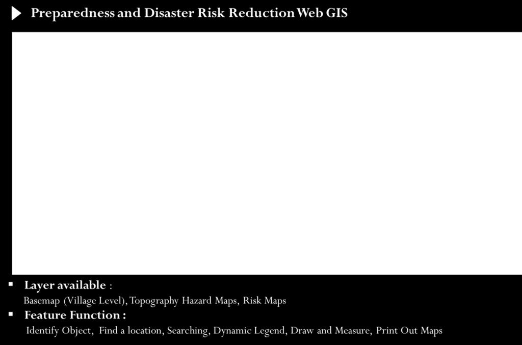
6 BNPB s Geospatial Information Web ( geospasial.bnpb.go.id) BNPB s Geospatial Information Web ( geospasial.bnpb.go.id) 6
 Coordination with Line Ministries National Geospatial Agency (Badan Informasi Geospasial/BIG): for mapping such as control points, GPS points, tidal data, base maps (topography maps) and thematic")
7 BNPB s Geospatial Information Web ( geospasial.bnpb.go.id) Coordination with Line Ministries National Geospatial Agency (Badan Informasi Geospasial/BIG): for mapping such as control points, GPS points, tidal data, base maps (topography maps) and thematic maps Ministry of Environment: to integrate disaster risk aspects into MOE s Climate Vulnerability Index Data Inventory System, a numerical and spatial data system Ministry of Public Works has developed Public Works Infrastructure GIS (SIGI-PU): a WebGIS application for conveying spatial information related to infrastructure development which support DM through the use of spatial information on infrastructure for mitigation, preparedness, response and recovery. 7
8 Coordination with Local Government Law No. 4 Year 2011 on Geospatial Information Local Government to development of accurate and accessible map and geospatial information Risk maps have also been made available for 33 provinces and more than 60 districts/cities. Recently BNPB has developed Earthquake, Tsunami, Volcanic Eruption, Flood and Landslide Risk Map of Indonesia Coordination with Other Stakeholders Universities/Academic Institutions: Personnel from universities/academic institutions are part of the team supporting the Local Government in developing and updating the risk map Private Sector: MoU between BNPB and Media Nusantara Citra (MNC) Group one of the largest integrated media corporation in Southeast Asia on disaster preparedness e.g., for the dissemination of information pre-, during and post-disaster International Organizations: UNDP, AIFDR, World Bank, and other international institutions in enhancing its geospatial database and information management system. 8
9 Measures taken in relation to HFA Priority 2 The development of the index for disaster risk at the provincial level and district/cities and sub district level Indonesia. The ranking of index of location which are prone of disaster are developed and documented on IRBI (Indeks Risiko Bencana Indonesia Indonesian Disaster Risk Index) - utilized for planning and regional budget planning by the National Ministry of Finance Development of risk map based on national regulation and guidelines of implementation, linked to provincial, district and sub district level for multi hazard and risk factors of the region. The Indonesian National Standard (SNI) related to evacuation route and risk map analysis which will be standardized for the whole nation. Risk Maps to be utilized with the integration of DRR into Spatial Planning as undertaken by the Ministry of Public Work on spatial planning Measures taken in relation to HFA Priority 5 The development of master plan for evacuation route for 16 tsunami-prone provinces. The development preparedness profiles at the national, provincial and district level (e.g, the exact location of all vital infrastructure with its resources and capacities information) Scenario identification/development for developing contingency planning, response operations, etc. The development of risk-based scenario for training and exercise at national and local level The establishment of Indonesia Scenario Assessment for Emergencies/ InaSAFE - a free software that produces realistic natural hazard impact scenarios for better planning, preparedness and response activities. The Establishment of InAWARE - Indonesia All-hazards WArning and Risk Evaluation. It is a web-based Decision Support System (DSS) for use by disaster managers at national and provincial levels 9


 Kawasan Santi Dharma, Pusat Misi Pemeliharaan")
10 Recommendations to the 3 rd World Conference on Disaster Risk Reduction (WCDRR) Growing importance of Geospatial Information in Disaster Management thus, national geospatial agencies to facilitate NDMAs to better utilize such information for disaster preparedness, response and recovery UN-GGIM-AP to further facilitate the transfer of technology and exchange of geospatial data and information in disaster management at country level Each country to prepare user friendly and accessible spatial and non-spatial data and information for community at large situ support from UN and international community THANK YOU Bernardus Wisnu Widjaja. Deputy Chief for Prevention and Preparedness Indonesian Disaster Relief Training Ground (INA-DRTG) Kawasan Santi Dharma, Pusat Misi Pemeliharaan Perdamaian Dunia (PMPP-ISPC) Sentul, Bogor, West Java - INDONESIA b.wisnu.w@bnpb.go.id 10
Role of Science and Technology in Disaster Preparedness in Indonesia
 2014/SOM3/EPWG/SDMOF/014 Session 1 Role of Science and Technology in Disaster Preparedness in Indonesia Submitted by: Indonesia 8 th Senior Disaster Management Officials Forum Beijing, China 11-12 August
Disaster Management in Republic of Korea
 The Third UN-GGIM-AP Plenary Meeting Disaster Management in Republic of Korea ~Coordination among NGIA & Other Related Organizations and Recommendations~ Bali Indonesia 10 November 2014 Sanghoon Lee, Ph.D.
SDI DEVELOPMENT UPDATES OF INDONESIA
 SDI DEVELOPMENT UPDATES OF INDONESIA DR. ANTONIUS B. WIJANARTO Center For Management And Dissemination Of Geospatial Information GEOSPATIAL INFORMATION AUTHORITY GOVERNMENT OF THE REPUBLIC OF INDONESIA
Report of the Working Group 2 Data Sharing and Integration for Disaster Management *
 UNITED NATIONS E/CONF.104/6 ECONOMIC AND SOCIAL COUNCIL Twentieth United Nations Regional Cartographic Conference for Asia and the Pacific Jeju, 6-9 October 2015 Item 5 of the provisional agenda Report
Roles of NGII in successful disaster management
 The Second UN-GGIM-AP Plenary Meeting Roles of NGII in successful disaster management Republic of Korea Teheran Iran 28 October 2013 Sanghoon Lee, Ph.D. NGII Outline Type of Disasters Occur in Korea Practical
NGIAs' roles in successful disaster response
 The Second UN-GGIM-AP Plenary Meeting NGIAs' roles in successful disaster response Japan Teheran Iran 28 October 2013 Shin-ichi SAKABE, Director of International Affairs Division Geospatial Information
NATIONAL FRAMEWORK FOR FLOOD DISASTER MANAGEMENT IN INDONESIA. 11 th GEOSS ASIA PASIFIC SYMPOSIUM Kyoto, October 2018
 NATIONAL FRAMEWORK FOR FLOOD DISASTER MANAGEMENT IN INDONESIA 11 th GEOSS ASIA PASIFIC SYMPOSIUM Kyoto, 24-26 October 2018 1 OUTLINE Disasters in Indonesia The Disaster Management Mechanism Current Status
Country Report Vanuatu
 Country Report Vanuatu Ministry Infrastructure and Public Utilities. Application of Space Technology and the Geographic information system for DRR and Sustainable Development 18 th 22 nd December 2012
Progress Report. Flood Hazard Mapping in Thailand
 Progress Report Flood Hazard Mapping in Thailand Prepared By: Mr. PAITOON NAKTAE Chief of Safety Standard sub-beuro Disaster Prevention beuro Department of Disaster Prevention and Mitigation THAILAND E-mail:
OMS CABO VERDE Newsletter Special Edition Fogo volcanic eruption : From the onset to the post-disaster assessment The role of the WHO
 OMS CABO VERDE Newsletter Special Edition Fogo volcanic eruption 2014-2015 : From the onset to the post-disaster assessment The role of the WHO Fig 1 - A view of the slowly advancing lava and the extent
INDONESIA S S UPDATE: GEOSPATIAL INFORMATION FOR SUSTAINABLE DEVELOPMENT RELATED TO INA SDI Dr. Asep Karsidi, M.Sc
 INDONESIA S S UPDATE: GEOSPATIAL INFORMATION FOR SUSTAINABLE DEVELOPMENT RELATED TO INA SDI Dr. Asep Karsidi, M.Sc GEOSPATIAL INFORMATION AGENCY 08 August, 2012 OUTLINE 1. Transformation Bakosurtanal into
INDONESIA IMPACT BASED FORECAST PROGRAM
 INDONESIA IMPACT BASED FORECAST PROGRAM Seoul, 19-21 November 2018 The 2nd Regional Workshop on Impact-based Forecasts in Asia Indonesia Agency for Meteorology Climatology and Geophysics (BMKG) A. Fachri
Journey of supporting CSNs to establish Geo-DRM
 Regional Workshop on Geo-referenced Information Systems for Disaster Risk Management (Geo-DRM) 26-27 June 2014 Bangkok, Thailand Journey of supporting CSNs to establish Geo-DRM Keran Wang Chief, Space
Development of Geospatial Information in Indonesia: Progress & Challenge
 Development of Geospatial Information in Indonesia: Progress & Challenge Dr. Nurwadjedi Sarbini Deputy of Thematic Geospatial Information Geospatial Information Agency (BIG) Geosmart Asia, September 29
Regional EGM on Community of Practice of Georeferenced Information System. for Disaster Risk Management (Geo-DRM) April 2014, Bangkok, Thailand
 April 2014, Bangkok, Thailand") Regional EGM on Community of Practice of Georeferenced Information System for Disaster Risk Management (Geo-DRM) 23-25 April 2014, Bangkok, Thailand Presented By Mukesh Kumar Keshari Ministry of Home Affairs
Regional EGM on Community of Practice of Georeferenced Information System for Disaster Risk Management (Geo-DRM) 23-25 April 2014, Bangkok, Thailand Presented By Mukesh Kumar Keshari Ministry of Home Affairs
DIPLOMA IN DISASTER MANAGEMENT. (Non-Semester) (With effect from the academic year )
 (With effect from the academic year )") DIPLOMA IN DISASTER MANAGEMENT (Non-Semester) (With effect from the academic year 2013-14) Eligibility for the Course Candidate should have passed the Higher Secondary Examination conducted by the Board
DIPLOMA IN DISASTER MANAGEMENT (Non-Semester) (With effect from the academic year 2013-14) Eligibility for the Course Candidate should have passed the Higher Secondary Examination conducted by the Board
SEISMIC RISK ASSESSMENT IN ARMENIA
 SEISMIC RISK ASSESSMENT IN ARMENIA Hovhannes Khangeldyan Head of National Crisis Management Center Rescue Service Ministry of Emergency Situations of the Republic of Armenia Tokyo, 2016 ARMENIA: GEOGRAPHICAL
Building Institutional Capacity for Multi-Hazard Early Warning in Asia and the Pacific Subtitle
 Building Institutional Capacity for Multi-Hazard Early Warning in Asia and the Pacific Subtitle Title Keran Wang Chief, Space Applications Section ICT and Disaster Risk Reduction Division 22 May 2018 Pillar
Strategic Framework on Geospatial Information and Services for Disasters
 Strategic Framework on Geospatial Information and Services for Disasters Case Studies for the Caribbean and the Philippines --- Kunming Forum on United Nations Global Geospatial Information Management
Sentinel Asia Tsunami Working Group
 Sentinel Asia Tsunami Working Group Co-Chairman: Prof. Shunichi Koshimura Abdul Muhari, PhD 4 th Joint Project Team Meeting (JPTM 2017): Sentinel Asia STEP 3 Abdul MUHARI, PhD Ministry of Marine Affairs
Disaster Management in Mongolia
 The Third UN-GGIM-AP Plenary Meeting Disaster Management in Mongolia ~Coordination among NGIA & Other Related Organizations and Recommendations~ Bali Indonesia 10 November 2014 Khurelshagai Ayurzana, Director
Use of geo-referenced data for DRM in Central Asia, problems and prospective
 Use of geo-referenced data for DRM in Central Asia, problems and prospective Dr. Akylbek Chymyrov Director, Kyrgyz Center of Geoinformation Systems Member of the Public Supervisory Board MES KR KSUCTA,
Disaster Management and Spatial Data An Experience of Sri Lanka for Joint project team meeting 2012
 Disaster Management and Spatial Data An Experience of Sri Lanka for Joint project team meeting 2012 1 by Padma Kumara Withana Provincial Surveyor General Uva Province 2 Out line ü Introduction ü Natural
The Role of Geospatial Information in Disaster Risk Reduction
 3rd High Level Forum on UN Global Geospatial Information Management in Beijing, Session 3: Climate Change and Disaster Mitigation 23 October 2014 The Role of Geospatial Information in Disaster Risk Reduction
GEOLOGICAL HAZARD MITIGATION STRATEGY IN INDONESIA
 GEOLOGICAL HAZARD MITIGATION STRATEGY IN INDONESIA Surono Head of Geological Agency presented in: The 2nd Global Summit of Research Institutes for Disaster Risk Reduction Kihada Hall, Uji Campus, Kyoto
Global Map: A Tool for Disaster Mitigation for the Asia and Pacific Region
 Global Map: A Tool for Disaster Mitigation for the Asia and Pacific Region D. R. Fraser Taylor Chair, International Steering Committee for Global Mapping (ISCGM) fraser_taylor@carleton.ca www. 18 th United
Country Report Nepal Geospatial Data Sharing Initiatives of Survey Department Supporting Disaster Management
 Third JPTM Step 2 for Sentinel Asia 6-8 July, 2010 Manila, The Philippines Country Report Nepal Geospatial Data Sharing Initiatives of Survey Department Supporting Disaster Management Durgendra M Kayastha
Georeferencing and Satellite Image Support: Lessons learned, Challenges and Opportunities
 Georeferencing and Satellite Image Support: Lessons learned, Challenges and Opportunities Shirish Ravan shirish.ravan@unoosa.org UN-SPIDER United Nations Office for Outer Space Affairs (UNOOSA) UN-SPIDER
Status and Challenges on Geo-DRM Information Systems in Tonga
 Name: Mafua- i-vai utukakau Maka Status and Challenges on Geo-DRM Information Systems in Tonga 1 Roles and Relationships Land and Geographic Information Systems (LGIS) Unit: Establish updated high-resolution
Disaster RISK Management : Bhutanese Scenario
 Disaster RISK Management : Bhutanese Scenario Expert Group Meeting (EGM) on Geo-referenced Information Systems for Disaster Risk Management (Geo-DRM) and sustaining the Community of Practice (COP), Bangkok,
CapacityAssessmentofNational MeteorologicalandHydrological ServicesinSupportof DisasterRiskReduction
 CapacityAssessmentofNational MeteorologicalandHydrological ServicesinSupportof DisasterRiskReduction Analysisofthe2006WMO DisasterRiskReduction Country-levelSurvey Capacity Assessment of National Meteorological
One Map Policy to Support National Development in Indonesia
 One Map Policy to Support National Development in Indonesia Dr. Nurwadjedi Sarbini Deputy of Thematic Geospatial Information Geospatial Information Agency (BIG) Geosmart Asia, September 29 October 1, 2015
Geo-information and Disaster Risk Reduction in the Hindu Kush-Himalayan region
 Geo-information and Disaster Risk Reduction in the Hindu Kush-Himalayan region Basanta Shrestha, Division Head MENRIS, International Centre for Integrated Mountain Development Kathmandu, Nepal The International
Application of a GIS for Earthquake Hazard Assessment and Risk Mitigation in Vietnam
 Application of a GIS for Earthquake Hazard Assessment and Risk Mitigation in Vietnam Nguyen Hong Phuong Earthquake Information and Tsunami Warning Centre, VAST OUTLINE Introduction Fault Source Model and
Landslide Hazard Assessment Methodologies in Romania
 A Scientific Network for Earthquake, Landslide and Flood Hazard Prevention SciNet NatHazPrev Landslide Hazard Assessment Methodologies in Romania In the literature the terms of susceptibility and landslide
GEO Geohazards Community of Practice
 GEO Geohazards Community of Practice 1) Co-Chair of GHCP With input from: Stuart Marsh, GHCP Co-Chair Francesco Gaetani, GEO Secretariat and many GHCP contributors 1) Nevada Bureau of Mines and Geology
Building Institutional Capacity for Multi-Hazard Early Warning in Pacific Countries Subtitle
 Building Institutional Capacity for Multi-Hazard Early Warning in Pacific Countries Subtitle Title Keran Wang Chief, Space Applications Section ICT and Disaster Risk Reduction Division 30 March 2018 Slide
Impact of Cyclone Nargis
 Lessons Learnt from Nargis Recovery for the Next Disaster International Recovery Forum (2011) 12, JAN 2011, Kobe, Japan Home for over 100 national races. Profile of Myanmar The 2 nd largest country in
Copernicus Overview and Emergency Management Service
 Copernicus Overview and Emergency Management Service Frédéric BASTIDE European Commission Open informal session of the United Nations Inter-Agency Meeting on Outer Space Activities 12 March 2013, Geneva
MOZAMBIQUE: Institutional Arrangements and Achievements
 UN-International Strategy for Disaster Reduction Global Platform for Disaster Risk Reduction- First Session MOZAMBIQUE: Institutional Arrangements and Achievements on Implementation of Hyogo Framework
Report of the Regional Committee of UN-GGIM for Asia and the Pacific (UN-GGIM-AP)
") Report of the Regional Committee of UN-GGIM for Asia and the Pacific (UN-GGIM-AP) At the Eighth Session of UN-GGIM UN Headquarters, New York, 1 3 August 2018 About UN-GGIM-AP One of the five regional committees
Report of the Regional Committee of UN-GGIM for Asia and the Pacific (UN-GGIM-AP) At the Eighth Session of UN-GGIM UN Headquarters, New York, 1 3 August 2018 About UN-GGIM-AP One of the five regional committees
Geospatial application in Kiribati
 Geospatial application in Kiribati ICC-21 ST RESAP (9 TH TO 13 TH OCTOBER, 2017) BANGKOK, THAILAND Outline Kiribati Profile Natural disasters in Kiribati Achievements Challenges/Issues Ways forward 1 Kiribati
UN GGIM and National SDI Strategy
 MSDI Open Forum on 26 th January 2016 Contributing to the successful delivery of MSDI UN GGIM and National SDI Strategy Hiroshi Murakami Deputy Administrator Geospatial Information Authority of Japan Geospatial
Disaster Management & Recovery Framework: The Surveyors Response
 Disaster Management & Recovery Framework: The Surveyors Response Greg Scott Inter-Regional Advisor Global Geospatial Information Management United Nations Statistics Division Department of Economic and
Building Disaster Resilience Community in Asia: Indonesian perspective
 Workshop C of the 7th Science Council of Asia (SCA) Conference Construction of Secure and Safe Society against Global Changes of Natural Disasters Okinawa, June 14 th, 2007 Building Disaster Resilience
Final Presentation on Disaster Risk Management in Japan. Through ADRC V. R Programme. Main Findings and Action Plan:
 Final Presentation on Disaster Risk Management in Japan Through ADRC V. R Programme Main Findings and Action Plan: Problem/Hazard and Disaster in Japan Good Practiced on Disaster Risk Management in Japan
Developing Local Government Capacity for SDI Development in Indonesia. Mulyanto Darmawan*, Heri Sutanta,** Adi Rusmanto*
 Developing Local Government Capacity for SDI Development in Indonesia Mulyanto Darmawan*, Heri Sutanta,** Adi Rusmanto* * Centre for Standardization and Institutionalis Aspect of Geospatial Information,
The Role Of Ina-SDI For Disaster Management
 The Second UN-GGIM-AP Plenary Meeting The Role Of Ina-SDI For Disaster Management Indonesia Tehran - Iran 28 October 2013 Dodi Sukmayadi Geospatial Information Authority of Indonesia (BIG) COMPONENT FOR
Economic and Social Council
 United Nation E/C.20/2012/4/Add.1 Economic and Social Council Distr.: General 2 July 2012 Original: English Committee of Experts on Global Geospatial Information Management Second session New York, 13-15
One map policy (OMP) implementation strategy to accelerate mapping of regional spatial planing (RTRW) in Indonesia
 implementation strategy to accelerate mapping of regional spatial planing (RTRW) in Indonesia") IOP Conference Series: Earth and Environmental Science PAPER OPEN ACCESS One map policy (OMP) implementation strategy to accelerate mapping of regional spatial planing (RTRW) in Indonesia To cite this
IOP Conference Series: Earth and Environmental Science PAPER OPEN ACCESS One map policy (OMP) implementation strategy to accelerate mapping of regional spatial planing (RTRW) in Indonesia To cite this
Progress on the Development of the Strategic Framework on Geospatial Information and Services for Disasters
 Progress on the Development of the Strategic Framework on Geospatial Information and Services for Disasters Dr. Peter N. Tiangco Administrator, NAMRIA, Philippines Co-chair, Working Group on Geospatial
DISATER MANAGEMENT IN LIBRARIES
 DISATER MANAGEMENT IN LIBRARIES by S. Padmashree National Seminar cum Workshop on Trends & Challenges in LIS Education and Profession March 24 25 th 2017 Andhra University, Visakhapatnam Disaster - A
World Meteorological Organization
 Appendix VI Presentation on disaster risk reduction brainstorming session (1) World Meteorological Organization WMO DRR Programme Dieter C. Schiessl Director, Weather and Disaster Risk Reduction Services
ESCAP Promotes Geo-referenced Information System for Disaster Risk Management in Asia and the Pacific
 Third High Level Forum on UNGGIM 22-24 October 2014 Beijing, China ESCAP Promotes Geo-referenced Information System for Disaster Risk Management in Asia and the Pacific Keran Wang Space Applications Section,
Copernicus Overview. Major Emergency Management Conference Athlone 2017
 Copernicus Overview Major Emergency Management Conference Athlone 2017 Copernicus is a European programme implemented by the European Commission. The services address six thematic areas: land, marine,
SPICE & Disaster Risk Managment
 SPICE & Disaster Risk Managment Linking Integrated Coastal Zone Management (ICZM) with Tsunami Disaster Risk Management: Some Experiences from Capacity Building Measures in Indonesia International Symposium
New Zealand s Next Top Model: integrating tsunami modelling into land use planning
 New Zealand s Next Top Model: integrating tsunami modelling into land use planning Wendy Saunders (MZNZPI), Gegar Prasetya, Graham Leonard GNS Science, Lower Hutt, w.saunders@gns.cri.nz In April 2011 a
Global Monitoring for Environment and Security (GMES)
") Global Monitoring for Environment and Security (GMES) Satellite Earth Observation for the Emergency Services Dr Nick Veck Presentation to the G-STEP Launch Univ. of Leicester 19 th June 2009 Contents of
Global Monitoring for Environment and Security (GMES) Satellite Earth Observation for the Emergency Services Dr Nick Veck Presentation to the G-STEP Launch Univ. of Leicester 19 th June 2009 Contents of
Integrated Geodatabase Model for effective planning of District -Hamirpur
 Integrated Geodatabase Model for effective planning of District -Hamirpur Developed by District Administration,Hamirpur in collaboration with Centre for Geoinformatics Research and Training, CSK HPAU,Palampur
Second Administrative Level Boundaries (SALB) initiative & geographic names in cartography. Geospatial Information Section
 initiative & geographic names in cartography. Geospatial Information Section") Second Administrative Level Boundaries (SALB) initiative & geographic names in cartography Geospatial Information Section Introduction Goals Global agenda How does SALB work? Latest News on geographic
Second Administrative Level Boundaries (SALB) initiative & geographic names in cartography Geospatial Information Section Introduction Goals Global agenda How does SALB work? Latest News on geographic
5. Principles. 1. Malaysia is not free from. Kuala Teriang, Langkawi
 5. Principles 1. Malaysia is not free from seismic-induced geohazards. However, the degree and magnitude of the geohazards are relatively small or minor because Malaysia is located in a stable tectonic
Overview of Early Warning Systems and the role of National Meteorological and Hydrological Services
 Overview of Early Warning Systems and the role of National Meteorological and Hydrological Services South Africa Second Experts Symposium on Multi-Hazard Early Warning Systems With focus on the Role of
STATUS OF HAZARD MAPS VULNERABILITY ASSESSMENTS AND DIGITAL MAPS
 JapanInternational Cooperation Agency STATUS OF HAZARD MAPS VULNERABILITY ASSESSMENTS AND DIGITAL MAPS ANGUILLA REPORT THE CARIBBEAN DISASTER EMERGENCY RESPONSE AGENCY () Table of Contents Page Preface
Table ronde 5 : Cartographie d'urgence Emergency Mapping.
 Table ronde 5 : Cartographie d'urgence Emergency Mapping MapAction is an international NGO that provides maps and other information services to help humanitarian relief organisations in the field MapAction
Climate Resilience Decision Making Framework in the Caribbean. A case of Spatial Data Management
 Climate Resilience Decision Making Framework in the Caribbean A case of Spatial Data Management Bishwa Pandey Sr. Data Management Specialist The World Bank Background The mission of The World Bank s Latin
Geospatial Information for Disaster Risk Management in Asia-Pacific Region
 Geospatial Information for Disaster Risk Management in Asia-Pacific Region Ram S. Tiwaree, Dr.Eng. Space Applications Section Information and Communications Technology and Disaster Risk Reduction Division
Status & Challengers of Cook Islands GEO DRM. Cook Islands GEO S/GIS History
 Status & Challengers of Cook Islands GEO DRM By Patrick A. ARIOKA Planning & Advisory Officer EMERGENCY MANAGEMENT COOK ISLANDS Cook Islands GEO S/GIS History 1990 NZODA/MFAT trained by Landcare Research
Disaster Risk Reduction in Survey for Seismic Protection of MES
 Survey for Seismic Protection Ministry of Emergency Situations of Republic of Armenia Disaster Risk Reduction in Survey for Seismic Protection of MES Syuzanna Kakoyan Leading specialist at the Department
Report of PCGIAP to the 18 th United Nations Regional Cartographic Conference for Asia and the Pacific (UNRCC-AP) for the period
 for the period") Permanent Committee on GIS Infrastructure for Asia and the Pacific (PCGIAP) Established in 1995 by a United Nations Resolution Report of PCGIAP to the 18 th United Nations Regional Cartographic Conference
Permanent Committee on GIS Infrastructure for Asia and the Pacific (PCGIAP) Established in 1995 by a United Nations Resolution Report of PCGIAP to the 18 th United Nations Regional Cartographic Conference
RESAP Progress Report
 RESAP Progress Report December 2016 to October 2017 Presentation to the Twenty-first session of the Intergovernmental Consultative Committee on the Regional Space Applications Programme for Sustainable
The Integration of Land and Marine Spatial Data Set As Part of Indonesian Spatial Data Infrastructure Development
 UNITED NATIONS E/CONF.97/6/IP. 46 ECONOMIC AND SOCIAL COUNCIL Seventeenth United Nations Regional Cartographic Conference for Asia and the Pacific Bangkok, 18-22 September 2006 Item 7 of the provisional
Challenges and Issues for Regional Geoportal on Disaster Data Sharing - from Perspective of China
 The 3 rd UN-GGIM-AP Plenary Meeting Challenges and Issues for Regional Geoportal on Disaster Data Sharing - from Perspective of China ZHOU Xu, Vice Chair of WG2 National Geomatics Center of China Outline
2014/TPTWG/WKSP/009 Resources Information System for Disaster Response - SIRAD
 2014/TPTWG/WKSP/009 Resources Information System for Disaster Response - SIRAD Submitted by: Peru Workshop on Improving Global Supply Chain Resilience: Advancing the Seven APEC Principles in Your Organization
RETA 6422: Mainstreaming Environment for Poverty Reduction Category 2 Subproject
 RETA 6422: Mainstreaming Environment for Poverty Reduction Category 2 Subproject A. Basic Data 1. Subproject Title: Poverty-Environment Mapping to Support Decision Making 2. Country Director: Adrian Ruthenberg
March 2007 The Survey Department of Sri Lanka
 Contribution of Survey Department of Sri Lanka for Mitigation of Disasters in Sri Lanka K.A.U.N.Kasthuri Deputy Surveyor General (Information Technology) March 2007 The Survey Department of Sri Lanka 1
Washington State K 12 Facilities Pre-Disaster Mitigation Program Final Mitigation Plan
 Washington State K 12 Facilities Pre-Disaster Mitigation Program Final Mitigation Plan ESD Meeting, January 2015 Office of Superintendent of Public Instruction School Facilities & Organization 1 Mitigating
Geospatial Information Management in the Americas: Lessons for the Post-2015 development agenda
 Geospatial Information Management in the Americas: Lessons for the Post-2015 development agenda Rolando Ocampo President, UN-GGIM: Americas October 2014 The integration of statistical and geographical
The challenge of risk communication how risk communication is the key to triggering action: Experiences from the Philippines and PNG
 The challenge of risk communication how risk communication is the key to triggering action: Experiences from the Philippines and PNG Dr Andrew Jones on behalf of the Regional Development Group and partners
SHARE. Structured Humanitarian Assistance Reporting
 SHARE Structured Humanitarian Assistance Reporting A Summary Description and Requirements for Geo-referenced Data Collection and Mapping to Support Humanitarian Assistance Operations Geographic Information
INTRODUCTION OF A SUCCESS STORY IN THE PHILIPPINES
 INTRODUCTION OF A SUCCESS STORY IN THE PHILIPPINES Arturo S. Daag Department of Science and Technology Philippine Institute of Volcanology and Seismology (DOST-PHIVOLCS) Establishment of Sentinel Asia
Applied Geoscience and Technology Division SOPAC. Joy Papao, Risk Information Systems Officer
 Joy Papao, Risk Information Systems Officer Secretariat of the Pacific Community SPC 22 Pacific Island States Head office in Noumea, New Caledonia 2 Regional offices (Pohnpei and Honiara) 600 staff 9 Technical
Disaster Risk Management in India. Kamal Kishore New Delhi, 27 October 2016
 Disaster Risk Management in India Kamal Kishore New Delhi, 27 October 2016 Hazard, Exposure and Vulnerability Disaster Prevention Mitigation Hurricane Matthew: Cuba & Haiti Emergency Response Coordination
GI Technology for Disaster Management
 GI Technology for Disaster Management 17 th ICC on the Regional Space Applications Programme for Sustainable Development (RESAP) 26 th Nov 2013 Bangkok Thailand Period and time of seasonal in thailand
Interpretive Map Series 24
 Oregon Department of Geology and Mineral Industries Interpretive Map Series 24 Geologic Hazards, and Hazard Maps, and Future Damage Estimates for Six Counties in the Mid/Southern Willamette Valley Including
Geospatial framework for monitoring SDGs/Sendai targets By Shimonti Paul Sr. Assistant Editor Geospatial Media & Communications
 Geospatial framework for monitoring SDGs/Sendai targets By Shimonti Paul Sr. Assistant Editor Geospatial Media & Communications Outline 1. Introduction to Geospatial Media and Communications 2. Geospatial
MAP FOR COMMUNICATING NATURAL HAZARDS: AN EVALUATION OF INDONESIA PRE-DISASTER SPATIAL INFORMATION
 CO-147 MAP FOR COMMUNICATING NATURAL HAZARDS: AN EVALUATION OF INDONESIA PRE-DISASTER SPATIAL INFORMATION NARIESWARI L., MUNAJATI S.L., KRESNAWATI D.K., WINDIASTUTI R. BAKOSURTANAL (National Coordinating
The Efforts of Building GIS Infrastructure in a Newly Independent State: The case of Timor Leste *
 UNITED NATIONS E/CONF.100/IP.12 ECONOMIC AND SOCIAL COUNCIL Eighteenth United Nations Regional Cartographic Conference for Asia and the Pacific Bangkok, 26-29 October 2009 Item 7(b) of the provisional
Weather Climate Science to Service Partnership South Africa
 PROJECTS UNDERWAY Title of the Weather Climate Science to Service Partnership South Africa Together, building on an existing strong partnership, South African Weather Service and the Met Office will build
Open Cities Project. The World Bank, South Asia Region. Background
 Open Cities Project The World Bank, South Asia Region Opencitiesproject.com Background The World Bank s South Asia Region (SAR) is proud to announce its new Open Cities Project. The goal of this project
KNOWLEDGE NOTE 5-1. Risk Assessment and Hazard Mapping. CLUSTER 5: Hazard and Risk Information and Decision Making. Public Disclosure Authorized
 Public Disclosure Authorized Public Disclosure Authorized Public Disclosure Authorized Public Disclosure Authorized KNOWLEDGE NOTE 5-1 CLUSTER 5: Hazard and Risk Information and Decision Making Risk Assessment
The World Bank BiH Floods Emergency Recovery Project (P151157)
") EUROPE AND CENTRAL ASIA Bosnia and Herzegovina Social, Urban, Rural and Resilience Global Practice Global Practice IBRD/IDA Investment Project Financing FY 2014 Seq No: 4 ARCHIVED on 22-Jun-2016 ISR22737
EUROPE AND CENTRAL ASIA Bosnia and Herzegovina Social, Urban, Rural and Resilience Global Practice Global Practice IBRD/IDA Investment Project Financing FY 2014 Seq No: 4 ARCHIVED on 22-Jun-2016 ISR22737
In Issue of International Sabo News Letter
 In Issue of International Sabo News Letter I had an opportunity to make a keynote speech on March 18 2003 at the session on Sedimentrelated Issues at the 3rd World Water Forum held in (Kyoto) Japan. Chairing
NCC roles in successful disaster response I.R.IRAN
 The Second UN-GGIM-AP Plenary Meeting NCC roles in successful disaster response I.R.IRAN Teheran Iran 28-30 October 2013 Ali Javidaneh Technical Deputy of National Cartographic Center (NCC) Outline Types
Center for Spatial Data Infrastructures and Land Administration Department of Geomatics, University of Melbourne. Content
 Heri SUTANTA, Abbas RAJABIFARD, Ian BISHOP Center for Spatial Data Infrastructures and Land Administration Department of Geomatics, University of Melbourne Content Introduction Coastal Urban Environment
The UN-GGIM: Europe core data initiative to encourage Geographic information supporting Sustainable Development Goals Dominique Laurent, France
 INSPIRE conference Strasbourg 6 September 2017 The UN-GGIM: Europe core data initiative to encourage Geographic information supporting Sustainable Development Goals Dominique Laurent, France Introduction
Geospatial natural disaster management
 Geospatial natural disaster management disasters happen. are you ready? Natural disasters can strike almost anywhere at any time, with no regard to a municipality s financial resources. These extraordinarily
WMO. Key Elements of PWS and Effective EWS. Haleh Haleh Kootval Chief, PWS Programme
 WMO Key Elements of PWS and Effective EWS Haleh Haleh Kootval Chief, PWS Programme Workshop Objectives This workshop is all about Service Delivery and becoming excellent at it through: Sharing experiences
Space Application in Support of Land Management for SDG Implementation
 Space Application in Support of Land Management for SDG Implementation Regional Expert Workshop on Land Accounting for SDG Monitoring and Reporting 26 September 2017 Space Application Section Information
USE OF GEOREFERENCE INFORMATION FOR DRM Arnob Bormdoi Research Associate, GIC
 USE OF GEOREFERENCE INFORMATION FOR DRM Arnob Bormdoi Research Associate, GIC CONTENTS INTRODUCTION THE IMPORTANCE OF SPATIAL INFORMATION CASE STUDIES SUMMARY INTRODUCTION The process of defining how raster
World Meteorological Organization
 World Meteorological Organization Opportunities and Challenges for Development of Weather-based Insurance and Derivatives Markets in Developing Countries By Maryam Golnaraghi, Ph.D. Head of WMO Disaster