Observatories in the context of the Digital Continent: CZO s and HIS
|
|
|
- Primrose Walker
- 5 years ago
- Views:
Transcription
1 Observatories in the context of the Digital Continent: CZO s and HIS Dr. Richard P. Hooper, President, Consortium of Universities for the Advancement of Hydrologic Science, Inc.
2 Why Observatories? From Grand Challenges to Decadal Goals Grand Challenge: Predict water quality and quantity anywhere in the US Quantitative integrated model of gw and sw (Flowpaths and residence time prediction) Grand Challenge: Effect of low frequency climate structure on hydrologic extremes Land surface-atmosphere model to predict soil moisture Grand Challenge: Adaptation and scaling or river networks, vegetation, and land forms Integrated model of fluvial geomorphology and ecohydrology
3 How many observatories? Network structure implied by decadal goal Example: GW/SW Interaction Hydrogeologic setting Depth of unsaturated zone Transfer of information from intensively studied observatories to less studied areas (inference ability) Modeling central to observatory efforts
4 Abstractions in Modeling Hydrologist Groundwater Contribution? Q, Gradient, Roughness?
5 Abstractions in Modeling Biogeochemist DOC Quality? Redox Zones? Hyporheic exchange? Mineralogy? Chemistry?
6 Abstractions in Modeling Geomorphologist Glaciated Valley Perifluvial Well sorted? Thalweg?
7 Abstractions in Modeling Aquatic Ecologist Oligotrophic? Carbon source? Backwater habitat Substrate Size, Stability? Benthic Community
8 Abstractions in Modeling Theory/Process Knowledge Perceptions of this place Intuition
9 Abstractions in Modeling Real World Physical World Conceptual Frameworks

10 Abstractions in Modeling Real World Water quantity and quality Conceptual Frameworks Physical World Measurements


11 Abstractions in Modeling Real World Physical World Conceptual Frameworks Meteorology Measurements


12 Abstractions in Modeling Real World Remote sensing Conceptual Frameworks Physical World Measurements


13 Abstractions in Modeling Real World Vegetation Survey Conceptual Frameworks Physical World Measurements

14 Abstractions in Modeling Real World DNA Sequences Conceptual Frameworks Physical World Measurements
15 Abstractions in Modeling Real World Physical World Conceptual Frameworks Geographically Referenced Measurements
16 Abstractions in Modeling Real World Conceptual Frameworks Physical World Mapping Data Representation
17 Real World Abstractions in Modeling Conceptual Frameworks Physical World Mapping Data Representation -Mathematical Formulae -Solution Techniques
18 Abstractions in Modeling Real World Digital Observatory Physical World Conceptual Frameworks Mapping Data Representation Model Representations Validation A single Data Representation supports multiple conceptualizations and models.
19 Data Representation Four-dimensional {x,y,z,t} Time, T D A data value Space, L Variable, V
20 Data Representation Four-dimensional {x,y,z,t} Continental scope
21 Data Representation Four-dimensional {x,y,z,t} Continental scope Multi-scale, multiresolution 1:1,000,000 scale North American and Global 1:500,000 scale United States 1:100,000 scale 1:24,000 scale 1:1200 scale Point scale River Basin Watershed River reach A plot

22 Data Representation Four-dimensional {x,y,z,t} Continental scope Multi-scale, multiresolution Points, coverages, dynamic fields
23 Digital Continent Integrating monitoring and research data yields a single body of information for the country Observatories contribute intensive information to this body Observatories are placed within context of climate, geology, soils, etc. but are not assumed to be representative of an area. Digital observatories may be watersheds, aquifers, river reaches, or any region that is part of the continent

24 Observation Stations Map for the US Ameriflux Towers (NASA & DOE) NOAA Automated Surface Observing System USGS National Water Information System NOAA Climate Reference Network
25 Observation Stations Map for the US Integrated through common data portal
26 Inference Space Transcending place means testing hypotheses in areas thought to be similar (in some attributes). Digital continent will enable identification of similar areas and (some) data about that spot. Observatories will enable inference about similar regions (e.g., presumably one can infer more about Delaware R. from Potomac than about Rio Grande).
27 DOs are the foundation of EOs Collaboration of Mission and Science Agencies DO contains both monitoring and research data DO supports hypothesis test, decision support systems, mgmt models Interdisciplinary communication Scientists can access multiple conceptualizations to improve understanding Everyone benefits from context provided Incentives must exist for people and agencies to want to contribute (and they do!)
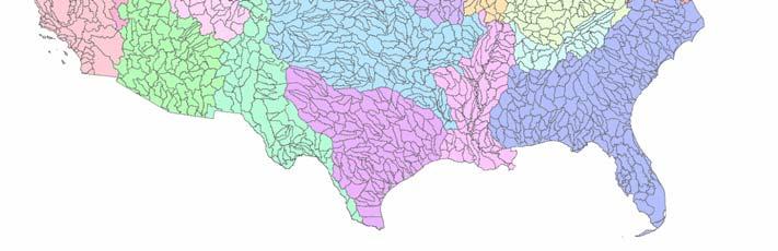
28 Water Resource Regions and HUC s


29 NHDPlus for Region 17E

30 NHDPlus Reach Catchments ~ 3km 2 Average reach length = 2km 2.3 million reaches for continental US About 1000 reach catchments in each 8-digit HUC

31 Reach Attributes Slope Elevation Mean annual flow Corresponding velocity Drainage area % of upstream drainage area in different land uses Stream order
32 HIS 1.0 (1 Nov 2006) Point Time Series Discovery and Publication Agencies USGS NWIS NCDC EPA Storet [LTER Trends] Static Federation to Observatory Test Beds
33 CUAHSI Hydrologic Information System Architecture National HIS San Diego Supercomputer Center Map interface, observations catalogs and web services for national data sources Workgroup HIS river authority, research centre or univ. Map interface, observations catalogs and web services for regional data sources; observations databases and web services for individual investigator data HIS Server Personal HIS an individual scientist or manager Application templates and HydroObjects for direct ingestion of data into analysis environments: Excel, ArcGIS, Matlab, programming languages; MyDB for storage of analysis data HIS Analyst

34 Supports data discovery, delivery and publication Data discovery how do I find the data I want? Map interface and observations catalogs Data delivery how do I acquire the data I want? Use web services or retrieve from local database Data Publication how do I publish my observation data? Use Observations Data Model HIS Server


35 National and Workgroup HIS National HIS Workgroup HIS National HIS has a polygon in it marking the region of coverage of a workgroup HIS server For HIS 1.0 the National and Workgroup HIS servers will not be dynamically connected. Workgroup HIS has local observations catalogs for coverage of national data sources in its region. These local catalogs are partitioned from the national observations catalogs.
36 Data Sources Storet NASA Ameriflux Extract NCDC Unidata NWIS NCAR Transform CUAHSI Web Services Excel ArcGIS Visual Basic C/C++ Load Applications Matlab Access Java Fortran Some operational services


37 How Excel connects to ODM Excel Obtains inputs for CUAHSI web methods from relevant cells. Available Web methods are GetSiteInfo, GetVariableInfo GetValues methods. HydroObjects parses user inputs into a standardized CUAHSI web method request. CUAHSI Web service converts standardized request to SQLquery. SQL query Observations Data Model imports VB object into Excel and graphs it converts XML to VB object converts response to a standardized XML. Response
38 Data Types Hydrologic Observation Data (Relational database) Digital Watershed Geospatial Data (GIS) Weather and Climate Data (NetCDF) Remote Sensing Data (EOS-HDF)
39 Digital Observatories Data Representation Need to develop integrated 4-dimensional data base Add coverages (easy) and fields (more complicated) Conceptual Frameworks and Modeling Can single data representation fulfill diverse set of science needs? Data assimilation techniques to guide sensor deployment and operation
40 HIS Extensions Integration of Weather Data Work with NCAR; prototype on Ohio Move from gridded to watershed-based delivery of data Hydrogeology Constructing stratigraphy for continent Geologic Framework Geomorphic and geologic history Incorporation of human dimension Transportation; structures Permits, Toxic Release Inventory, etc. Flood plain (contribution from real estate sector?) FEMA Lidar products Explicit development of AK, HI, PR beyond CONUS
41 HIS and CZOs CZOs can deploy workgroup HIS Need dedicated server (~$5K) ArcServer, SQLServer (potentially free) DataLoader for point data (ODM) provided Need information manager HIS can provide Clipped data catalogs for point time series, coverages Registration in national catalog for publication
42 CZOs and CUAHSI CZOs are high priority for support from CUAHSI HMF pilot geophysics activities Beta test group for HIS products and set priorities for development Community access Data publication Basin user s guides Education and outreach
43 Beyond CZOs O&M for Environmental Observatories a major concern for NSF Seeking active engagement from science and regulatory agencies to develop collaborative observatories Academic research: new technology, basic research and students Mission agencies: Operational support, infrastructure, applied research Use CZO experience to tailor effective engagement of mission agencies
The CUAHSI Hydrologic Information System
 The CUAHSI Hydrologic Information System Presented by Dr. Tim Whiteaker The University of Texas at Austin 18 November, 2010 Session T1B About the Speaker PhD 2004 Research Associate What You Will Learn
GIS in Water Resources
 GIS in Water Resources David R. Maidment Center for Research in Water Resources University of Texas at Austin GIS Day @ KU 19 November 2008 GIS and Water Resources WaterML Water Data Language Observations
RHOAPS. Real-time Hydrology Ocean Atmosphere Prediction System. Pronunciation: Ropes Motto: More than just THREDDS
 RHOAPS Real-time Hydrology Ocean Atmosphere Prediction System Pronunciation: Ropes Motto: More than just THREDDS Key Aspects Integrated real-time data systems Atmospheric Hydrologic Coastal oceans Societal
Water Data Sharing an Update
 Water Data Sharing an Update By David R. Maidment Leader, CUAHSI Hydrologic Information System Project and Director, Center for Research in Water Resources, University of Texas at Austin Prepared for Subcommittee
The Open Geospatial Consortium and EarthCube
 The Open Geospatial Consortium and EarthCube An EarthCube Technology Paper Prepared by David Maidment 1, Ben Domenico 2, Alastair Gemmell 3, Kerstin Lehnert 4, David Tarboton 5 and Ilya Zaslavsky 6 Introduction
GIS at UCAR. The evolution of NCAR s GIS Initiative. Olga Wilhelmi ESIG-NCAR Unidata Workshop 24 June, 2003
 GIS at UCAR The evolution of NCAR s GIS Initiative Olga Wilhelmi ESIG-NCAR Unidata Workshop 24 June, 2003 Why GIS? z z z z More questions about various climatological, meteorological, hydrological and
Focus Areas. Colorado Rio Grande Jemez. San Pedro. An NSF Science and Technology Center SAHRA
 Focus Areas 1 San Pedro Colorado Rio Grande Jemez Geo-database Structure 2 SGB Schemas Upper Rio Grande Research Data Flux Tower Data Public Data Hydrology Rules, Users and Procedures Jemez River Colorado
The Open Geospatial Consortium and EarthCube
 The Open Geospatial Consortium and EarthCube An EarthCube Technology Paper Prepared by David Maidment 1, Ben Domenico 2, Alastair Gemmell 3, Kerstin Lehnert 4, David Tarboton 5 and Ilya Zaslavsky 6 Introduction
USGS Hydrography Overview. May 9, 2018
 + 1 USGS Hydrography Overview May 9, 2018 + 2 The National Geospatial Program Provides the geospatial baseline of the Nation s topography, natural landscape and built environment through The National Map,
StreamStats: Delivering Streamflow Information to the Public. By Kernell Ries
 StreamStats: Delivering Streamflow Information to the Public By Kernell Ries U.S. Department of the Interior U.S. Geological Survey MD-DE-DC District 410-238-4317 kries@usgs.gov StreamStats Web Application
Discovery and Access to Global Water Data, Maps and Services
 Discovery and Access to Global Water Data, Maps and Services David K. Arctur, PhD david.arctur@utexas.edu University of Texas at Austin Open Geospatial Consortium (OGC) Esri International User Conference
Susquehanna River Basin A Research Community Hydrologic Observatory. NSF-Funded Infrastructure Proposal in Support of River Basin Hydrologic Sciences
 Susquehanna River Basin A Research Community Hydrologic Observatory NSF-Funded Infrastructure Proposal in Support of River Basin Hydrologic Sciences Fundamental Problem: How Do Humans and Climate Impact
USGS National Geospatial Program Understanding User Needs. Dick Vraga National Map Liaison for Federal Agencies July 2015
 + USGS National Geospatial Program Understanding User Needs Dick Vraga National Map Liaison for Federal Agencies July 2015 + Topics 2 Background Communities of Use User Surveys National Map Liaisons Partnerships
Lecture 3. Data Sources for GIS in Water Resources
 Lecture 3 Data Sources for GIS in Water Resources GIS in Water Resources Spring 2015 http://www.data.gov/ 1 USGS GIS data for Water http://water.usgs.gov/maps.html Watersheds of the US 2-digit water resource
Introduction: The Gulf of Mexico Alliance. The Gulf GAME project MERMAid and PHINS Results & Conclusions What s next? Examples
 AAG Las Vegas March 25, 2009 Introduction: Ocean governance and Ecosystem-Based Management The Gulf of Mexico Alliance Habitat Identification and Characterization The Gulf GAME project MERMAid and PHINS
National Flood Interoperability Experiment
 National Flood Interoperability Experiment David R. Maidment, University of Texas at Austin Catchment-based Hydrological Data Assimilation (CAHMDA) VI Conference 8 September 2014 Located on Tuscaloosa
Management and Sharing of Hydrologic Information of Cache County
 Geographic Information System in Water Resources CEE6440 Fall Semester 2012 Management and Sharing of Hydrologic Information of Cache County To: Dr. David Tarboton Instructor By: Tian Gan Dec.7, 2012 I.
Breakout Session III Evolving landscapes and global environmental change
 Breakout Session III Evolving landscapes and global environmental change 1. Hydrology and critical zone imaging 2. Glaciology: Instrumenting glaciers and ice sheets 3. Polar networks and glacial isostatic
CAUSES FOR CHANGE IN STREAM-CHANNEL MORPHOLOGY
 CAUSES FOR CHANGE IN STREAM-CHANNEL MORPHOLOGY Chad A. Whaley, Department of Earth Sciences, University of South Alabama, MobileAL, 36688. E-MAIL: caw408@jaguar1.usouthal.edu The ultimate goal of this
ArcGIS Online Tools and Water-Related Web Services You Can Use Every Day of Your Life!
 ArcGIS Online Tools and Water-Related Web Services You Can Use Every Day of Your Life! Brian Rowley, PE, CFM FMA 2014 Annual Conference 1 Gold Rush (49ers) John Sutter Sutter s Mill South fork of American
ENV208/ENV508 Applied GIS. Week 1: What is GIS?
 ENV208/ENV508 Applied GIS Week 1: What is GIS? 1 WHAT IS GIS? A GIS integrates hardware, software, and data for capturing, managing, analyzing, and displaying all forms of geographically referenced information.
GIS in Weather and Society
 GIS in Weather and Society Olga Wilhelmi Institute for the Study of Society and Environment National Center for Atmospheric Research WAS*IS November 8, 2005 Boulder, Colorado Presentation Outline GIS basic
What s New in Topographic Information - USGS National Map
 + What s New in Topographic Information - USGS National Map SARGIS Workshop November 14, 2016 Rob Dollison, 703-648-5724 rdollison@usgs.gov + USGS 2 National Geospatial Program The National Geospatial
Spatial Data Availability Energizes Florida s Citizens
 NASCIO 2016 Recognition Awards Nomination Spatial Data Availability Energizes Florida s Citizens State of Florida Agency for State Technology & Department of Environmental Protection Category: ICT Innovations
Graduate Courses Meteorology / Atmospheric Science UNC Charlotte
 Graduate Courses Meteorology / Atmospheric Science UNC Charlotte In order to inform prospective M.S. Earth Science students as to what graduate-level courses are offered across the broad disciplines of
4. GIS Implementation of the TxDOT Hydrology Extensions
 4. GIS Implementation of the TxDOT Hydrology Extensions A Geographic Information System (GIS) is a computer-assisted system for the capture, storage, retrieval, analysis and display of spatial data. It
Services for Inland Marine Data Integration. USGS Center for Integrated
 Services for Inland Marine Data Integration USGS Center for Integrated Data Analytics Outline GeoDataPortal Tools Coastal Use Cases Beach hhealth lthmodeling Distributed Rainfall Analysis for Integration
Introduction. Elevation Data Strategy. Status and Next Steps
 1 2 Introduction Elevation Data Strategy Status and Next Steps 3 Canada is the 2nd largest country in the world - 9.9 million sq km Surrounded by 3 oceans with 202 000 km of coastline Population over 35
National Climatic Data Center Data Management Issues Tom Karl Director, NOAA s National Climatic Data Center
 National Climatic Data Center Data Management Issues Tom Karl Director, NOAA s National Climatic Data Center Opening Meeting NOAA Science Advisory Board s Data Archiving and Access Requirements Working
Model Calibration and Forecast Error for NFIE-Hydro
 Corey Van Dyk C E 397 Flood Forecasting 5/8/15 Model Calibration and Forecast Error for NFIE-Hydro Introduction The forecasting component of the National Flood Interoperability Experiment (NFIE), like
5A.10 A GEOSPATIAL DATABASE AND CLIMATOLOGY OF SEVERE WEATHER DATA
 5A.10 A GEOSPATIAL DATABASE AND CLIMATOLOGY OF SEVERE WEATHER DATA Steve Ansari * and Stephen Del Greco NOAA National Climatic Data Center, Asheville, North Carolina Mark Phillips University of North Carolina
Application of GIS Technology in Watershed-based Management and Decision Making
 Application of GIS Technology in Watershed-based Management and Decision Making U. Sunday Tim Iowa State University Department of Agricultural and Biosystems Engineering 100 Davidson Hall Email:
BSYSE 456/556 Surface Hydrologic Processes and Modeling
 BSYSE 456/556 Surface Hydrologic Processes and Modeling Lab 9 (Prepared by Erin Brooks and Jan Boll, UI, and Joan Wu, WSU) P Introduction One of the most difficult tasks in watershed assessment and management
USGS National Hydrography Dataset (NHD) and NHDPlus
 and NHDPlus") + 1 + USGS National Hydrography Dataset (NHD) and NHDPlus Al Rea USGS National Geospatial Program Western States Water Council August 1, 2018 + 2 USGS National Hydrography Datasets Hydrologic networks,
+ 1 + USGS National Hydrography Dataset (NHD) and NHDPlus Al Rea USGS National Geospatial Program Western States Water Council August 1, 2018 + 2 USGS National Hydrography Datasets Hydrologic networks,
What s new in GIS. RAL Retreat Oct 5, 2005
 What s new in GIS RAL Retreat Oct 5, 2005 Overview GIS Initiative milestones Major activities in 2004-2005 GALEON UNIDATA OGC project New functionality in ESRI software GIS Initiative Team Olga Wilhelmi
Thales Canada, System Division. BattleView: Integrating ArcGIS Into Canadian Army s Command And Control Application
 BattleView: Integrating ArcGIS Into Canadian Army s Command And Control Application BattleView Overview Canadian Army s command and control (C2) application Deployed in army headquarters unit and above
GIS Solutions in Natural Resource Management: Balancing the Technical- Political Equation
 GIS Solutions in Natural Resource Management: Balancing the Technical- Political Equation Stan Morain, Editor SUB Gdttlngen 7 208 520 309 98 A14447 0NW0RD PRESS V? % \
Surface Processes Focus on Mass Wasting (Chapter 10)
") Surface Processes Focus on Mass Wasting (Chapter 10) 1. What is the distinction between weathering, mass wasting, and erosion? 2. What is the controlling force in mass wasting? What force provides resistance?
Surface Processes Focus on Mass Wasting (Chapter 10) 1. What is the distinction between weathering, mass wasting, and erosion? 2. What is the controlling force in mass wasting? What force provides resistance?
NEEA Refresh aka 3D Nation Requirements and Benefits Study. Allyson Jason, Carol Ostergren, Xan Fredericks and Lou Driber November 9, 2017
 + NEEA Refresh aka 3D Nation Requirements and Benefits Study Allyson Jason, Carol Ostergren, Xan Fredericks and Lou Driber November 9, 2017 + 2 Study Context Background The National Enhanced Elevation
SYNERGY OF SATELLITE REMOTE SENSING AND SENSOR NETWORKS ON GEO GRID
 SYNERGY OF SATELLITE REMOTE SENSING AND SENSOR NETWORKS ON GEO GRID National Institute of Advanced Industrial Science and Technology, Japan Yoshio Tanaka (on behalf of AIST GEO Grid team) Contents Brief
Streamlined Watershed Modeling with the Kentucky Watershed Modeling Information Portal (KWMIP)
") Streamlined Watershed Modeling with the Kentucky Watershed Modeling Information Portal (KWMIP) JSEM 2007 Geospatial Technical Session Columbus, Ohio May 23, 2007 Ray Rush, PE Information Solutions Manager
Streamlined Watershed Modeling with the Kentucky Watershed Modeling Information Portal (KWMIP) JSEM 2007 Geospatial Technical Session Columbus, Ohio May 23, 2007 Ray Rush, PE Information Solutions Manager
GIS-based Water Resource Geospatial Infrastructure for Oil Shale Development
 GIS-based Water Resource Geospatial Infrastructure for Oil Shale Development Wendy Zhou, Matthew Minnick, Mengistu Geza Colorado School of Mines, Golden, CO Kyle Murray University of Texas at San Antonio,
Harrison 1. Identifying Wetlands by GIS Software Submitted July 30, ,470 words By Catherine Harrison University of Virginia
 Harrison 1 Identifying Wetlands by GIS Software Submitted July 30, 2015 4,470 words By Catherine Harrison University of Virginia cch2fy@virginia.edu Harrison 2 ABSTRACT The Virginia Department of Transportation
Web-Based Engine For Discovery Of Observations Using Landscape Units
 City University of New York (CUNY) CUNY Academic Works International Conference on Hydroinformatics 8-1-2014 Web-Based Engine For Discovery Of Observations Using Landscape Units Haowen Xu Abbas Ali Amir
Climate Data for Non-experts: Standards-based Interoperability
 Climate Data for Non-experts: Standards-based Interoperability Ben Domenico Unidata Program Center University Corporation for Atmospheric Research April 2010 Working Together on A Mosaic for Atmospheric
Proof of Concept for an Enterprise Environmental Spatial System Spatial Knowledge and Integrated Environmental System (SKIES)
") 2013 Esri International User Conference July 8 12, 2013 San Diego, California Proof of Concept for an Enterprise Environmental Spatial System Spatial Knowledge and Integrated Environmental System (SKIES)
2013 Esri International User Conference July 8 12, 2013 San Diego, California Proof of Concept for an Enterprise Environmental Spatial System Spatial Knowledge and Integrated Environmental System (SKIES)
GEOGRAPHIC INFORMATION SYSTEMS (GIS) AT GERS LAB
 AT GERS LAB") GEOGRAPHIC INFORMATION SYSTEMS (GIS) AT GERS LAB Fernando Gilbes Santaella GERS Lab-Department of Geology University of Puerto Rico at Mayaguez fernando.gilbes@upr.edu Geological and Environmental Remote
GEOGRAPHIC INFORMATION SYSTEMS (GIS) AT GERS LAB Fernando Gilbes Santaella GERS Lab-Department of Geology University of Puerto Rico at Mayaguez fernando.gilbes@upr.edu Geological and Environmental Remote
GERSVIEW: A New Database for Web Mapping
 GERSVIEW: A New Database for Web Mapping William J. Hernández, M.S. Graduate Student Department of Marine Sciences-UPRM Fernando Gilbes, Ph.D. Associate Professor Department of Geology-UPRM Overview Introduction
Introduction to Geographic Information Systems (GIS): Environmental Science Focus
: Environmental Science Focus") Introduction to Geographic Information Systems (GIS): Environmental Science Focus September 9, 2013 We will begin at 9:10 AM. Login info: Username:!cnrguest Password: gocal_bears Instructor: Domain: CAMPUS
Introduction to Geographic Information Systems (GIS): Environmental Science Focus September 9, 2013 We will begin at 9:10 AM. Login info: Username:!cnrguest Password: gocal_bears Instructor: Domain: CAMPUS
Water & Climate; Floods & Droughts (The yin & yang of water availablilty) Water & Climate; Floods & Droughts (The yin & yang of water availablilty)
 Water & Climate; Floods & Droughts (The yin & yang of water availablilty)") (Acknowledgment: This presentation was developed in collaboration with ESA, NEON and NCEAS, federal agencies and academic team members from minority serving institutions.) Water & Climate; Floods & Droughts
(Acknowledgment: This presentation was developed in collaboration with ESA, NEON and NCEAS, federal agencies and academic team members from minority serving institutions.) Water & Climate; Floods & Droughts
Rainfall-River Forecasting: Overview of NOAA s Role, Responsibilities, and Services
 Dr. Thomas Graziano Chief Hydrologic Services Division NWS Headquarters Steve Buan Service Coordination Hydrologist NWS North Central River Forecast Center Rainfall-River Forecasting: Overview of NOAA
THE WASHINGTON COASTAL ATLAS
 THE ICAN COASTAL ATLAS MEDIATOR PROTOTYPE AND CONNECTING THE WASHINGTON COASTAL ATLAS Liz O Dea 1, Yassine Lassoued 2, Tanya Haddad 3, Declan Dunne 2 1 GIS Services Unit, WA State Dept. of Ecology 2 Coastal
Geospatial Data, Services, and Products. National Surveying, mapping and geospatial conference
 Geospatial Data, Services, and Products Federal Programs -- USDA NRCS National Surveying, mapping and geospatial conference March 15, 2016 NRCS Applications using Geosaptial Products & Services Field
INSPIREd solutions for Air Quality problems Alexander Kotsev
 INSPIREd solutions for Air Quality problems Alexander Kotsev www.jrc.ec.europa.eu Serving society Stimulating innovation Supporting legislation The European data puzzle The European data puzzle 24 official
Advancing Flood Detection and Preparedness through GEOSS Water Services
 Advancing Flood Detection and Preparedness through GEOSS Water Services David K. Arctur University of Texas at Austin Open Geospatial Consortium (OGC) CAHMDA/DAFOH Joint Workshop University of Texas at
Louisiana Transportation Engineering Conference. Monday, February 12, 2007
 Louisiana Transportation Engineering Conference Monday, February 12, 2007 Agenda Project Background Goal of EIS Why Use GIS? What is GIS? How used on this Project Other site selection tools I-69 Corridor
Introduction to Geographic Information Systems
 Introduction to Geographic Information Systems Lynn_Carlson@brown.edu 401-863-9917 The Environmental And Remote TecHnologies Lab MacMillan Hall, Room 105 http://www.brown.edu/research/earthlab/ Outline
AIM Master Sample: A Tool to Support Statistically Valid Sample Designs
 AIM Master Sample: A Tool to Support Statistically Valid Sample Designs AIM A National Strategy designed to: Promote integrated, cross-program resource inventory, assessment, and monitoring at multiple
Northrop Grumman Concept Paper
 Northrop Grumman Concept Paper A Comprehensive Geospatial Web-based Solution for NWS Impact-based Decision Support Services Glenn Higgins April 10, 2014 Northrop Grumman Corporation Information Systems
Conference panel Session 98, Defining Data Professionals A Geospatial Industry Perspective on Becoming a Data Professional
 Conference panel Session 98, Defining Data Professionals A Geospatial Industry Perspective on Becoming a Data Professional Dawn J. Wright, Environmental Systems Research Institute (aka Esri), Redlands,
Using netcdf and HDF in ArcGIS. Nawajish Noman Dan Zimble Kevin Sigwart
 Using netcdf and HDF in ArcGIS Nawajish Noman Dan Zimble Kevin Sigwart Outline NetCDF and HDF in ArcGIS Visualization and Analysis Sharing Customization using Python Demo Future Directions Scientific Data
NEXRAD Severe Weather Signatures in the NOAA Severe Weather Data Inventory. Steve Ansari *, Mark Phillips, Stephen Del Greco
 NEXRAD Severe Weather Signatures in the NOAA Severe Weather Data Inventory Steve Ansari *, Mark Phillips, Stephen Del Greco NOAA National Climatic Data Center, Asheville, North Carolina ABSTRACT The Severe
Launch of Data Collection or Production Centre for World Weather Information Service
 Launch of Data Collection or Production Centre for World Weather Information Service The Hong Kong Observatory (HKO) announces that the Data Collection or Production Centre (DCPC) for the World Weather
Designing a Dam for Blockhouse Ranch. Haley Born
 Designing a Dam for Blockhouse Ranch Haley Born CE 394K GIS in Water Resources Term Paper Fall 2011 Table of Contents Introduction... 1 Data Sources... 2 Precipitation Data... 2 Elevation Data... 3 Geographic
GROUNDWATER CONFIGURATION IN THE UPPER CATCHMENT OF MEGHADRIGEDDA RESERVOIR, VISAKHAPATNAM DISTRICT, ANDHRA PRADESH
 GROUNDWATER CONFIGURATION IN THE UPPER CATCHMENT OF MEGHADRIGEDDA RESERVOIR, VISAKHAPATNAM DISTRICT, ANDHRA PRADESH Prof.P.Jagadeesara Rao Department of Geo-Engineering and Centre for Remote Sensing, College
A GIS-based Approach to Watershed Analysis in Texas Author: Allison Guettner
 Texas A&M University Zachry Department of Civil Engineering CVEN 658 Civil Engineering Applications of GIS Instructor: Dr. Francisco Olivera A GIS-based Approach to Watershed Analysis in Texas Author:
Improving the Interoperability of Earth Observations. An EarthCube White Paper. Jeffery S. Horsburgh 1, David G. Tarboton 1.
 Improving the Interoperability of Earth Observations An EarthCube White Paper Jeffery S. Horsburgh 1, David G. Tarboton 1 October 16, 2011 1. Introduction In the history of science, many significant advances
The National Operational Hydrologic Remote Sensing Center Operational Snow Analysis
 The National Operational Hydrologic Remote Sensing Center Operational Snow Analysis World Meteorological Organization Global Cryosphere Watch Snow-Watch Workshop Session 3: Snow Analysis Products Andrew
a system for input, storage, manipulation, and output of geographic information. GIS combines software with hardware,
 Introduction to GIS Dr. Pranjit Kr. Sarma Assistant Professor Department of Geography Mangaldi College Mobile: +91 94357 04398 What is a GIS a system for input, storage, manipulation, and output of geographic
Wetlands and Riparian Mapping Framework Technical Meeting
 Wetlands and Riparian Mapping Framework Technical Meeting Meghan Burns Landscape Ecologist Linda Vance Senior Ecologist Why wetland and riparian mapping? Preliminary site assessment for the presence of
Chesapeake Bay Remote Sensing Pilot Executive Briefing
 Chesapeake Bay Remote Sensing Pilot Executive Briefing Introduction In his Executive Order 13506 in May 2009, President Obama stated The Chesapeake Bay is a national treasure constituting the largest estuary
Imagery and the Location-enabled Platform in State and Local Government
 Imagery and the Location-enabled Platform in State and Local Government Fred Limp, Director, CAST Jim Farley, Vice President, Leica Geosystems Oracle Spatial Users Group Denver, March 10, 2005 TM TM Discussion
GMES Service for Geospatial Reference Data Access (RDA) Covering Areas Outside Europe
 Covering Areas Outside Europe") INSPIRE Conference 2011 Edinburgh 27 June - 1 July GMES Service for Geospatial Reference Data Access (RDA) Covering Areas Outside Europe Andrea Ajmar, Simone Balbo, Piero Boccardo, Simone Dalmasso, Anna
INSPIRE Conference 2011 Edinburgh 27 June - 1 July GMES Service for Geospatial Reference Data Access (RDA) Covering Areas Outside Europe Andrea Ajmar, Simone Balbo, Piero Boccardo, Simone Dalmasso, Anna
Leon Creek Watershed October 17-18, 1998 Rainfall Analysis Examination of USGS Gauge Helotes Creek at Helotes, Texas
 Leon Creek Watershed October 17-18, 1998 Rainfall Analysis Examination of USGS Gauge 8181400 Helotes Creek at Helotes, Texas Terrance Jackson MSCE Candidate University of Texas San Antonio Abstract The
Operational water balance model for Siilinjärvi mine
 Operational water balance model for Siilinjärvi mine Vesa Kolhinen, Tiia Vento, Juho Jakkila, Markus Huttunen, Marie Korppoo, Bertel Vehviläinen Finnish Environment Institute (SYKE) Freshwater Centre/Watershed
Hydrologic and Hydraulic Analyses Using ArcGIS
 Hydrologic and Hydraulic Analyses Using ArcGIS Two day training class Overview ArcGIS and Arc Hydro provide strong foundation for support of hydrologic and hydraulic (H&H) analyses. This two-day course
Transboundary water management with Remote Sensing. Oluf Jessen DHI Head of Projects, Water Resources Technical overview
 Transboundary water management with Remote Sensing Oluf Jessen DHI Head of Projects, Water Resources Technical overview ozj@dhigroup.com Transboundary water management Water management across national
A Temporal Hydrologic Database for Rapidly Changing Landscapes
 A Temporal Hydrologic Database for Rapidly Changing Landscapes Using Mt. St. Helens in Washington as a Pilot Site Adam Mosbrucker Geog 575 BACKGROUND: Client / User U.S. Geological Survey Cascades Volcano
NATIONAL WATER RESOURCES OUTLOOK
 NATIONAL WATER RESOURCES OUTLOOK American Meteorological Society Annual Meeting 24 th Hydrology Conference 9.2 James Noel Service Coordination Hydrologist National Weather Service-Ohio River Forecast Center
Hydrologic Engineering Applications of Geographic Information Systems
 Hydrologic Engineering Applications of Geographic Information Systems Davis, California Objectives: The participant will acquire practical knowledge and skills in the application of GIS technologies for
The 3D Elevation Program: Overview. Jason Stoker USGS National Geospatial Program ESRI 2015 UC
 + The 3D Elevation Program: Overview Jason Stoker USGS National Geospatial Program ESRI 2015 UC + 2 A little history USGS has a long, proud tradition of mapmaking (2009) + 3 The changing times Mapping
Watershed Application of WEPP and Geospatial Interfaces. Dennis C. Flanagan
 Watershed Application of WEPP and Geospatial Interfaces Dennis C. Flanagan Research Agricultural Engineer USDA-Agricultural Research Service Adjunct Professor Purdue Univ., Dept. of Agric. & Biol. Eng.
GOVERNMENT OF NEPAL MINISTRY OF IRRIGATION GROUND WATER RESOURCES DEVELOPMENT BOARD BABARMAHAL, KATHMANDU, NEPAL
 GOVERNMENT OF NEPAL MINISTRY OF IRRIGATION GROUND WATER RESOURCES DEVELOPMENT BOARD BABARMAHAL, KATHMANDU, NEPAL GIS Based Updating of Groundwater Level Siraha District Final Report Submitted to Ground
China-U.S. Collaboration on Rapid Urbanization. Jonathan Fink Vice President for Research and Economic Affairs Arizona State University August, 2004
 China-U.S. Collaboration on Rapid Urbanization Jonathan Fink Vice President for Research and Economic Affairs Arizona State University August, 2004 Why have an urban system science research agenda? More
ArcGIS Web Tools, Templates, and Solutions for Defence & Intelligence. Renee Bernstein Esri Solutions Engineer
 ArcGIS Web Tools, Templates, and Solutions for Defence & Intelligence Renee Bernstein Esri Solutions Engineer ArcGIS Solutions Includes 450+ Industry Focused Apps and Capabilities Organized by 9 Primary
EnviroAtlas: An Atlas about Ecosystems and their Connection with People
 EnviroAtlas: An Atlas about Ecosystems and their Connection with People Annie Neale, Megan Mehaffey & Atlas Team ASWM Webinar October, 17 th, 2012 What is it? The Atlas is an online decision support tool
Spatial Data Management of Bio Regional Assessments Phase 1 for Coal Seam Gas Challenges and Opportunities
 Spatial Data Management of Bio Regional Assessments Phase 1 for Coal Seam Gas Challenges and Opportunities By Dr Zaffar Sadiq Mohamed-Ghouse Principal Consultant, Spatial & IT, GHD zaffar.sadiq@ghd.com
the IRIS Consortium Collaborative, Multi-user Facilities for Research and Education Briefing NSF Business Systems Review September 9, 2008
 the IRIS Consortium Collaborative, Multi-user Facilities for Research and Education Briefing NSF Business Systems Review September 9, 2008 A facilities program for collection and distribution of seismological
ENVIRONMENTAL GEOSCIENCE UNIFORM SYLLABUS
 ENVIRONMENTAL GEOSCIENCE UNIFORM SYLLABUS The Association of Professional Engineers and Geoscientists of the Province of British Columbia Note: 1. This Syllabus May Be Subject To Change 2. These Courses
Hydrography Program Highlights and Demonstrations
 Hydrography Program Highlights and Demonstrations 2018-05-09, Reston North American Mapping Mark Sondheim & Marie-Eve Martin Overview Common Hydrology Features model: CHyF (chief) Linked Open Data: LOD
Summary Description Municipality of Anchorage. Anchorage Coastal Resource Atlas Project
 Summary Description Municipality of Anchorage Anchorage Coastal Resource Atlas Project By: Thede Tobish, MOA Planner; and Charlie Barnwell, MOA GIS Manager Introduction Local governments often struggle
Automated Identification and Characterization of Landforms on Mars
 Automated Identification and Characterization of Landforms on Mars Tomasz F. Stepinski Lunar and Planetary Institute Collaborators: Wei Luo Students: Brain Bue Ian Molloy Erik Urbach Michael Mendenhall
Distinct landscape features with important biologic, hydrologic, geomorphic, and biogeochemical functions.
 1 Distinct landscape features with important biologic, hydrologic, geomorphic, and biogeochemical functions. Have distinguishing characteristics that include low slopes, well drained soils, intermittent
GEOGRAPHIC INFORMATION SYSTEMS AND IT SOLUTIONS FOR THE ENVIRONMENT
 GEOGRAPHIC INFORMATION SYSTEMS AND IT SOLUTIONS FOR THE ENVIRONMENT Mission We focus on Solutions is a worldwide operating business offering Geographic Information Systems and IT solutions to assist environmental
Impact Policies Enabling Value Enhancement of Geospatial Information in Canadian Economy and Society
 1 Impact Policies Enabling Value Enhancement of Geospatial Information in Canadian Economy and Society May 26, 2015 Prashant Shukle, Director General Canada Centre for Mapping and Earth Observation Increased
Existing NWS Flash Flood Guidance
 Introduction The Flash Flood Potential Index (FFPI) incorporates physiographic characteristics of an individual drainage basin to determine its hydrologic response. In flash flood situations, the hydrologic
Progress on GCOS-China CMA IOS Development Plan ( ) PEI, Chong Department of Integrated Observation of CMA 09/25/2017 Hangzhou, China
 PEI, Chong Department of Integrated Observation of CMA 09/25/2017 Hangzhou, China") Progress on GCOS-China CMA IOS Development Plan (2016-2020) PEI, Chong Department of Integrated Observation of CMA 09/25/2017 Hangzhou, China 1. Progress on GCOS-China 1 Organized GCOS-China GCOS-China
Progress on GCOS-China CMA IOS Development Plan (2016-2020) PEI, Chong Department of Integrated Observation of CMA 09/25/2017 Hangzhou, China 1. Progress on GCOS-China 1 Organized GCOS-China GCOS-China
What is a watershed or landscape perspective?
 What is a watershed or landscape perspective? -remove sediment -add sediment -add wood, riparian manipulation -alter (engineer) channel/floodplain morphology -restore/abandon roads You are here What is
Geoscience Information Network (US GIN)
") Geoscience Information Network (US GIN) 1,000 s of databases 1,000 s of collections 80,000+ geologic maps Distributed Web-based Interoperable Open source A different business model Traditional Lobby Congress
Geoscience Information Network (US GIN) 1,000 s of databases 1,000 s of collections 80,000+ geologic maps Distributed Web-based Interoperable Open source A different business model Traditional Lobby Congress
NAVAJO NATION PROFILE
 NAVAJO NATION PROFILE Largest land based area and federally recognized tribe in the United States Over 27,000 square miles (or 17.2 million acres with a population of over 300,000 people. Covers Arizona,