GIS-based Water Resource Geospatial Infrastructure for Oil Shale Development
|
|
|
- Branden Higgins
- 6 years ago
- Views:
Transcription

1 GIS-based Water Resource Geospatial Infrastructure for Oil Shale Development Wendy Zhou, Matthew Minnick, Mengistu Geza Colorado School of Mines, Golden, CO Kyle Murray University of Texas at San Antonio, San Antonio, TX Water and Energy in Changing Climate Conference Pittsburgh, PA
2 Outline Brief Introduction to the Project Data Collection and Database Design ArcHydro Data Framework SQL Server 2008 Spatial Database Modeling 3D Geological Model Groundwater Model Surface Water Model Dynamic Systems Model Data Dissemination and Model Result Visualization Web-based GIS Summaries

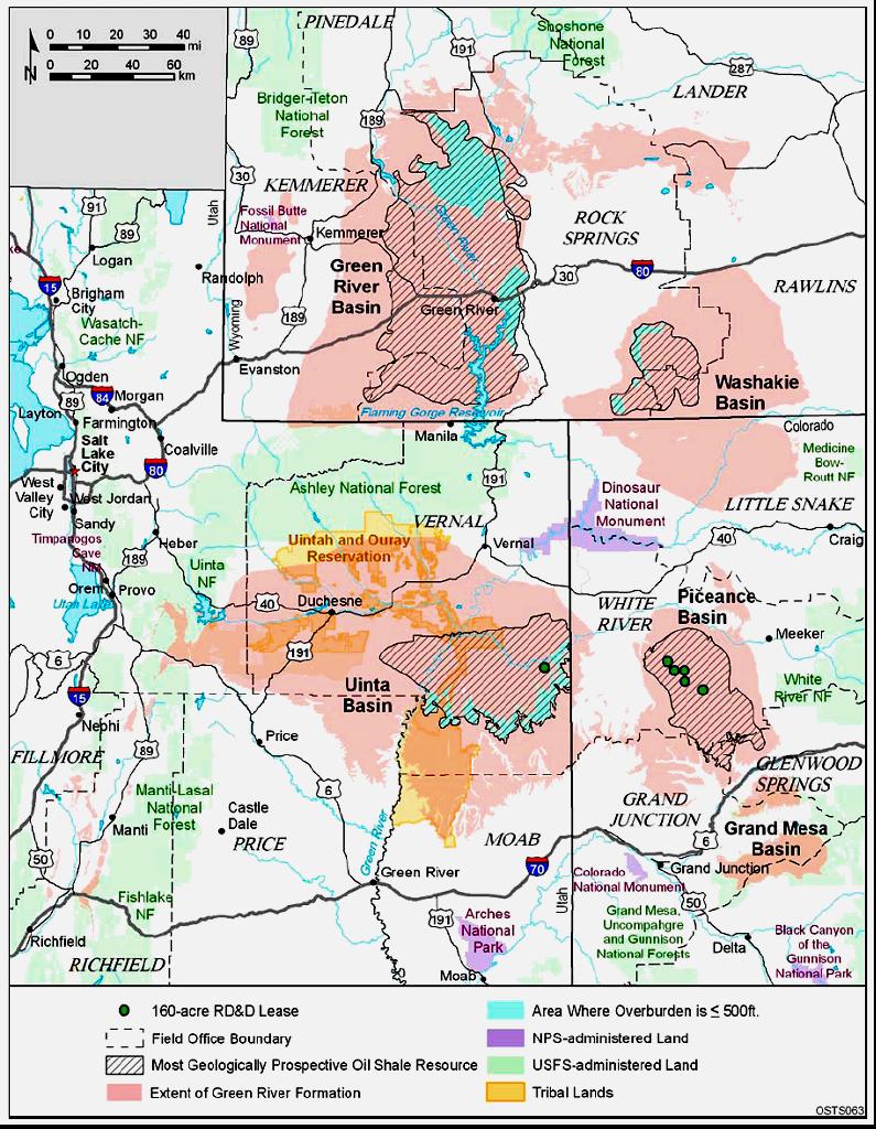
3 Brief Intro to the Project Funding Agency: NETL/DOE, DE-NT Duration: October 2008 ~ September 2011 Goal: To develop a water resource geospatial infrastructure that serves as baseline data for creating solutions on water resource management and for making decisions on oil shale resource development Performers: Colorado School of Mines: Wendy Zhou, Matt Minnick, Mengistu Geza, Elif Acikalin, Jerry Boak University of Texas at San Antonio: Kyle Murray, Tuan B Lee Idaho National Laboratory: Earl Mattson, Kara Eby, Carl Palmer Collaborators: USGS Energy Resources Program, Denver, CO Los Alamos National Laboratory, Los Alamos, NM USGS Colorado Water Science Center, Grand Junction, CO 81506


4 Global Oil Shale Resource 1. Piceance Basin (GRF) 1,525 billion barrels (modified from Boak, 2009)
5
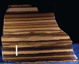
6 Oil shale zone Oil in place (bbs) Top A-groove-top bed A-groove 6.3 Mahogany zone B-groove 7.8 R L R L R L R L R L R L R Total this assessment: 1,525.2 USGS Resource Estimation ~3 bbs of Water per bbs of Oil Water Quantity and Quality

7 Nahcolite: NaHCO3 Dawsonite: NaAl(OH)2CO3 Halite: NaCl Total in-place nahcolite: 43.3 billion tons. Total carbon dioxide in this resource: 11.3 billion tons. USGS, 2010
8
9
10
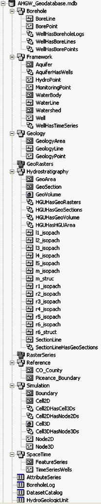
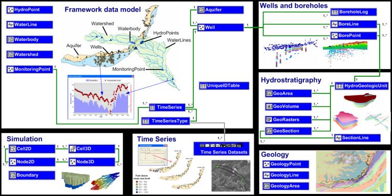

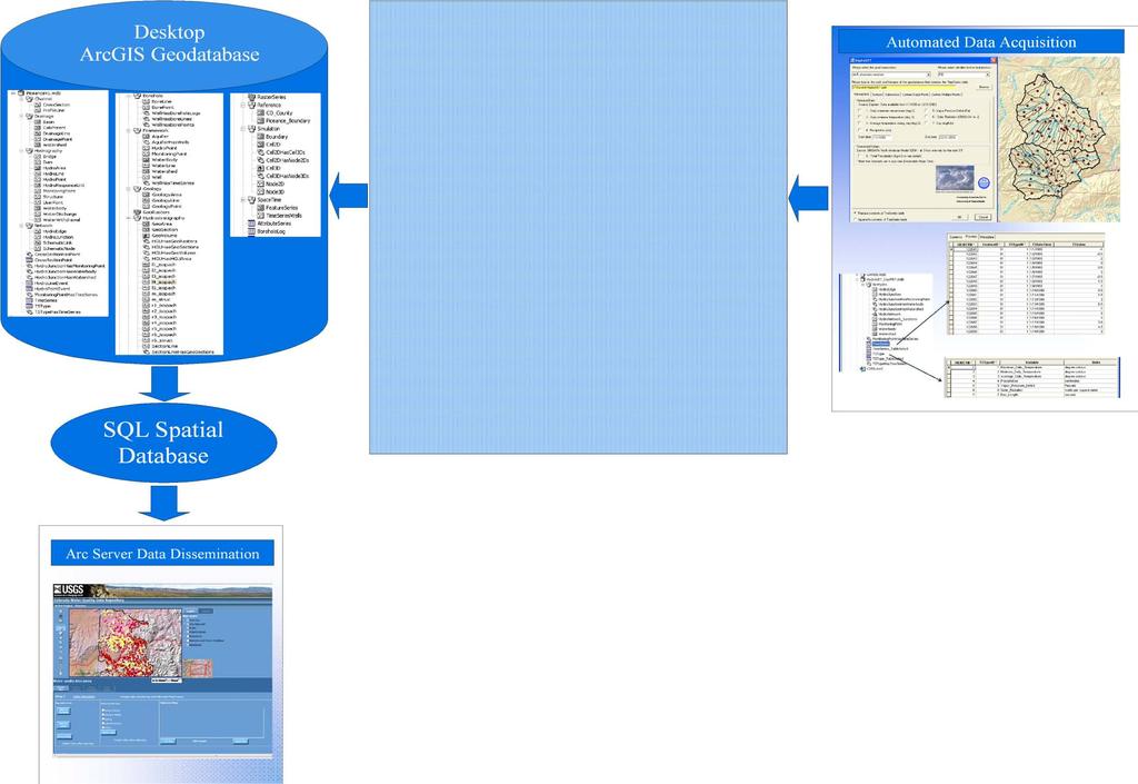
11 Geospatial Infrastructure
12


 with")

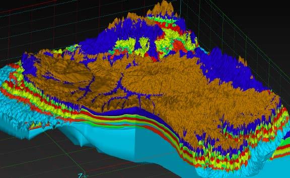
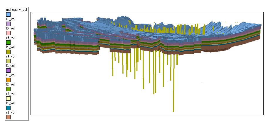
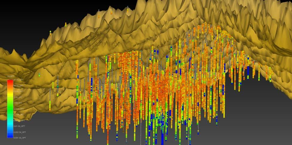
13 3D Geological Model Visualization of the Oil content in Gallons per Ton from the Fisher assays measurements in MVS (Mining Visualization System) with the top surface defined by a 10 meter DEM (Digital Elevation Model)
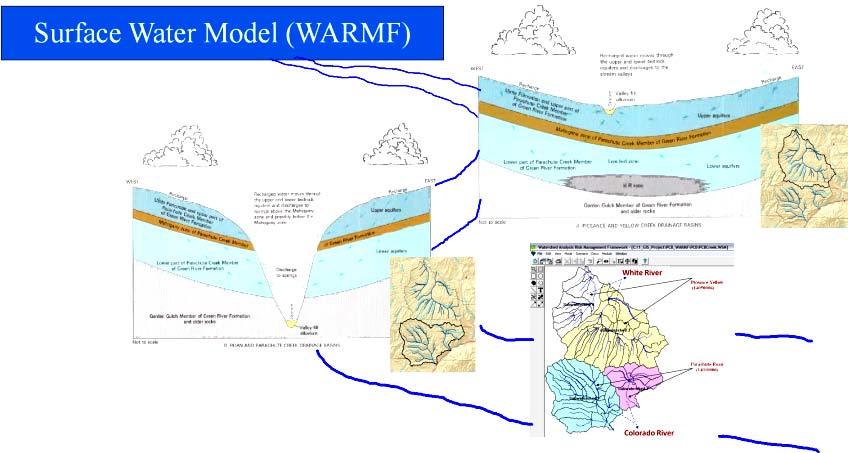
14 WARMF Model Framework Meteorological data Air Quality Watershed characteristics Land use Catchment areas/slope Soil properties Managed Flow Diversions from streams for energy Pumping ground water Reservoir data Point Sources Build a Watershed Model Calibrate model - Outputs Compare Model Outputs Under Different Oil Shale Production Scenarios Water Quantity-Stream Water level Water Quality Sediment and chemicals Develop a Water resource Management plan based on model prediction Generate information useful to Planners and Regulators

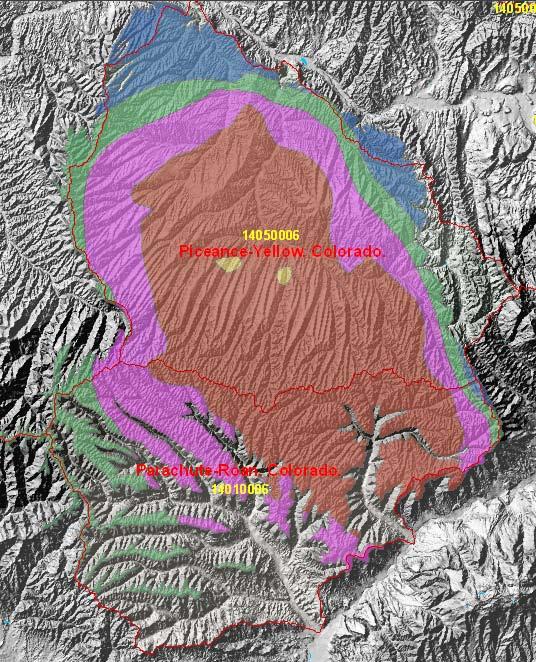
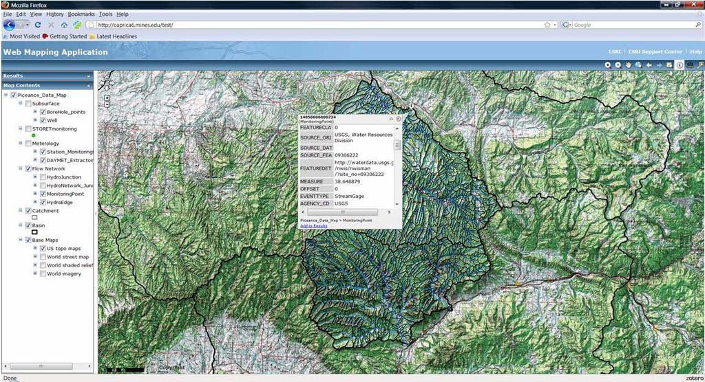
15 Integrated Geodatabase Piceance-Yellow ( ) White River The Watershed Analysis Risk Management Framework (WARMF) is capable of simulating surface water hydrology including the impact of water use on stream flow and pollutant transport and reactions. A river basin is divided into a network of land catchments, stream segments, and lakes for hydrologic and water-quality simulations. Stream flow is calculated based on water balance. Parachute-Roan ( ) Colorado River N YELLOW CREEK NEAR WHITE RIVER, CO Rio Blanco Garfield Kilometers Reach File, V1 DEM (m) County Boundarie


16 Surface and Groundwater Interaction Northern Subbasins: Piceance- Yellow (White River) (CGS, 2001) Southern Subbasins: Parachute- Roan (Colorado River)
17


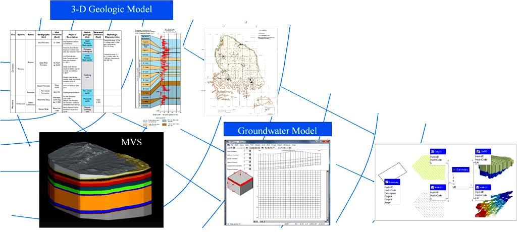
18 Visual MODFLOW Integrated Geodatabase 3D Geologic Model
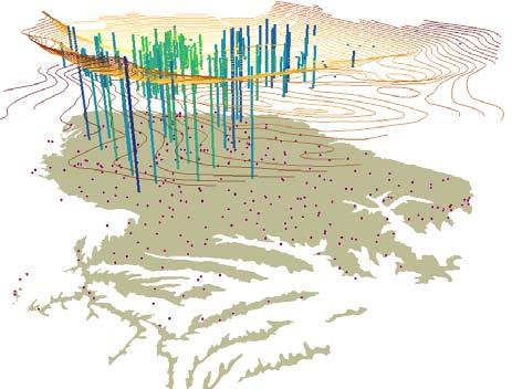
19 FORMATION MEMBER OIL SHALE ZONES & MARKER UNITS HYDROGEOLOGIC UNITS GENERAL HYDROGEOLOGIC FUNCTION MODFLOW LAYER AVERAGE THICKNESS (FEET) Surficial Alluvium Surficial Aquifer Layer1 50 Uinta Hydro5 Upper Aquifers Layer2 360 Green River Parachute Creek A groove Hydro4 Layer3 350 Wasatch Garden Gulch Mahogany Hydro3 Aquitard Layer4 141 B groove Hydro2 Lower Aquifers Layer5 174 R-6 L-5 Hydro1 Layer6 435 R-5 L-4 R-4 L-3 R-3 L-2 R-2 L-1 Hydro0 Aquitard Layer7 NA R-1 L-0 R-0 Correlation Chart for Hydrogeologic Units (Taylor, 1982)

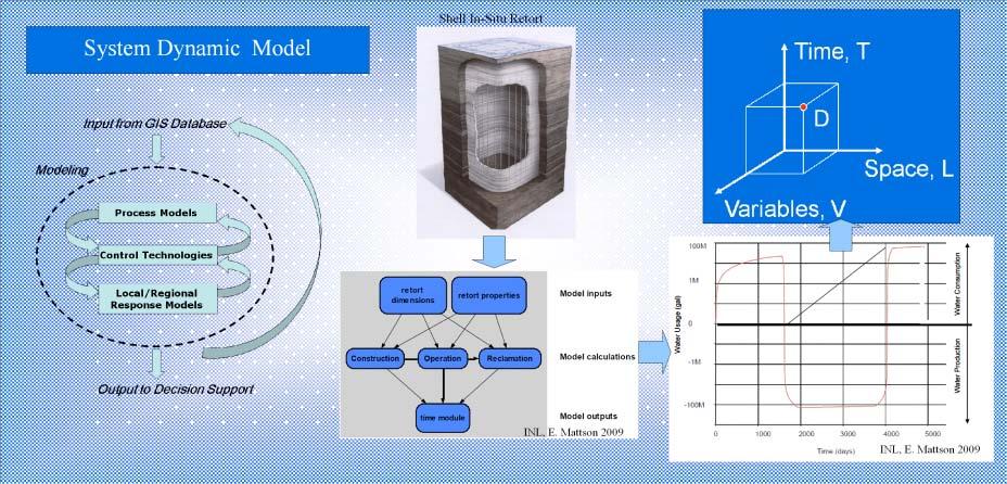
20 Integrated Geodatabase Construction retort dimensions Operation retort properties Reclamation Model inputs Model calculations time module Model outputs Input from GIS Database Input from GIS Database buffer length frz w all w idth Frz w all lgt Modeling Modeling retort w idth frz w all length Frz Area Frz w all surface area retort length depth of frz w all calc frz w all volume Process Models depth to w ater calc area of retort calc vol of retort height of retort Control Technologies Local/Regional Response Models Output to Decision Support Output to Decision Support (Mattson, 2009) e e e e e e e e e+006 water usage graph (gal) 100M 10M 1M 100K 0-100K -1M -10M -100M -1G Time
21

22 Summaries Development of the water resource geospatial infrastructure creates a repository for large volumes of geological, hydro-geological, topological, water resource and oil shale data. This data repository will allow for collaborative regional/basin assessments for future oil shale development. This type of collaboration provides an ideal atmosphere for the development of new, generically useful approaches to the use of new technology, and procedures that promote the best and most widespread use of our enormous data holdings despite their disparate locations and heterogeneous formats. The components in the infrastructure, including data frame, databases customized tools and models, are designed to be interlinked. These interlinks allow for synchronized updating. The final results of this projects shall facilitate answering such questions as, the amount of oil shale resource, water availability, and potential environmental impacts under various development scenarios. The procedures/tools/models developed in this research are designed to be general. These procedures/tools/models are readily adopted to other study areas.

23 Thank you and Questions?
Basin-wide Evaluation of the Uppermost Green River Formation s s Oil-Shale Resource, Uinta Basin, Utah and Colorado
 Basin-wide Evaluation of the Uppermost Green River Formation s s Oil-Shale Resource, Uinta Basin, Utah and Colorado Michael D. Vanden Berg Utah Geological Survey November 13, 2008 Acknowledgements U.S.
New Mexico Geological Society
 New Mexico Geological Society Downloaded from: http://nmgs.nmt.edu/publications/guidebooks/32 Rio Blanco Oil Shale Company Tract C-a, Rio Blanco County, Colorado: Summary of geology and current development
Dawsonite breakdown reactions during pyrolysis in Green River Formation oil shale
 Dawsonite breakdown reactions during pyrolysis in Green River Formation oil shale Jeremy Boak, Colorado School of Mines Justin Birdwell, U. S. Geological Survey Outline Saline Minerals in Green River Formation
Utah s s Oil Shale Deposits: Stratigraphy and Resource Evaluation
 Utah s s Oil Shale Deposits: Stratigraphy and Resource Evaluation Michael D. Vanden Berg Utah Geological Survey 27 th Oil Shale Symposium October 2007 Outline 1) Utah Oil Shale Database 2) Historical oil
StreamStats: Delivering Streamflow Information to the Public. By Kernell Ries
 StreamStats: Delivering Streamflow Information to the Public By Kernell Ries U.S. Department of the Interior U.S. Geological Survey MD-DE-DC District 410-238-4317 kries@usgs.gov StreamStats Web Application
SOLUTION MINING OF NAHCOLITE AT THE AMERICAN SODA PROJECT, PICEANCE CREEK, COLORADO. M. Hardy Agapito Assocs., Inc. Grand Junction, CO
 Preprint 03-105 SOLUTION MINING OF NAHCOLITE AT THE AMERICAN SODA PROJECT, PICEANCE CREEK, COLORADO M. Hardy Agapito Assocs., Inc. Grand Junction, CO M. Ramey C. Yates K. Nielsen American Soda, LLP Parachute,
INTRODUCTION TO HEC-HMS
 INTRODUCTION TO HEC-HMS Hydrologic Engineering Center- Hydrologic Modeling System US Army Corps of Engineers Hydrologic Engineering Center HEC-HMS Uses Schematics Enter properties: watershed, rivers (reaches),
A GIS-based Approach to Watershed Analysis in Texas Author: Allison Guettner
 Texas A&M University Zachry Department of Civil Engineering CVEN 658 Civil Engineering Applications of GIS Instructor: Dr. Francisco Olivera A GIS-based Approach to Watershed Analysis in Texas Author:
Operational water balance model for Siilinjärvi mine
 Operational water balance model for Siilinjärvi mine Vesa Kolhinen, Tiia Vento, Juho Jakkila, Markus Huttunen, Marie Korppoo, Bertel Vehviläinen Finnish Environment Institute (SYKE) Freshwater Centre/Watershed
Pierce Cedar Creek Institute GIS Development Final Report. Grand Valley State University
 Pierce Cedar Creek Institute GIS Development Final Report Grand Valley State University Major Goals of Project The two primary goals of the project were to provide Matt VanPortfliet, GVSU student, the
Management and Sharing of Hydrologic Information of Cache County
 Geographic Information System in Water Resources CEE6440 Fall Semester 2012 Management and Sharing of Hydrologic Information of Cache County To: Dr. David Tarboton Instructor By: Tian Gan Dec.7, 2012 I.
P.R. SPRING AND HILL CREEK TAR SAND AREAS A RESOURCE ASSESSMENT (IN PROGRESS)
") P.R. SPRING AND HILL CREEK TAR SAND AREAS A RESOURCE ASSESSMENT (IN PROGRESS) presented by WALLY GWYNN - Utah Geological Survey at the Western U.S. Oil Sands Technology Transfer Meeting February 22, 2008
P.R. SPRING AND HILL CREEK TAR SAND AREAS A RESOURCE ASSESSMENT (IN PROGRESS) presented by WALLY GWYNN - Utah Geological Survey at the Western U.S. Oil Sands Technology Transfer Meeting February 22, 2008
Surface Processes Focus on Mass Wasting (Chapter 10)
") Surface Processes Focus on Mass Wasting (Chapter 10) 1. What is the distinction between weathering, mass wasting, and erosion? 2. What is the controlling force in mass wasting? What force provides resistance?
Surface Processes Focus on Mass Wasting (Chapter 10) 1. What is the distinction between weathering, mass wasting, and erosion? 2. What is the controlling force in mass wasting? What force provides resistance?
Regional groundwater mapping and model
 Regional groundwater mapping and model Boyd, Dwight 1, Steve Holysh 2, and Jeff Pitcher 1 1 Grand River Conservation Authority, Canada; 2 Regional Municipality of Halton, Canada The Grand River forms one
Development of an Aquifer Information System for Assessment and Allocation of Ground-Water in the Atlantic Coastal Plain
 Development of an Aquifer Information System for Assessment and Allocation of Ground-Water in the Atlantic Coastal Plain 2006 State County Ground Water Symposium September 20, 2006 Baltimore, Maryland
MEMORANDUM. Jerry Conrow, Ojai Basin Groundwater Management Agency
 MEMORANDUM TO: FROM: Jerry Conrow, Ojai Basin Groundwater Management Agency Gregory Schnaar, PhD, Stephen J. Cullen, PhD, PG, DATE: August 6, 2014, 2014 SUBJECT: Ojai Basin Groundwater Model - Extended
Application of GIS Technology in Watershed-based Management and Decision Making
 Application of GIS Technology in Watershed-based Management and Decision Making U. Sunday Tim Iowa State University Department of Agricultural and Biosystems Engineering 100 Davidson Hall Email:
Leon Creek Watershed October 17-18, 1998 Rainfall Analysis Examination of USGS Gauge Helotes Creek at Helotes, Texas
 Leon Creek Watershed October 17-18, 1998 Rainfall Analysis Examination of USGS Gauge 8181400 Helotes Creek at Helotes, Texas Terrance Jackson MSCE Candidate University of Texas San Antonio Abstract The
THE HISTORY AND PERFORMANCE OF VERTICAL WELL SOLUTION MINING OF NAHCOLITE (NaHCO 3 ) IN THE PICEANCE BASIN, NORTHWESTERN COLORADO, USA
 IN THE PICEANCE BASIN, NORTHWESTERN COLORADO, USA") Solution Mining Research Institute; Fall 2004 Technical Meeting Berlin, Germany THE HISTORY AND PERFORMANCE OF VERTICAL WELL SOLUTION MINING OF NAHCOLITE (NaHCO 3 ) IN THE PICEANCE BASIN, NORTHWESTERN
Solution Mining Research Institute; Fall 2004 Technical Meeting Berlin, Germany THE HISTORY AND PERFORMANCE OF VERTICAL WELL SOLUTION MINING OF NAHCOLITE (NaHCO 3 ) IN THE PICEANCE BASIN, NORTHWESTERN
Hydrologic Modelling of the Upper Malaprabha Catchment using ArcView SWAT
 Hydrologic Modelling of the Upper Malaprabha Catchment using ArcView SWAT Technical briefs are short summaries of the models used in the project aimed at nontechnical readers. The aim of the PES India
GAM Run by Ali H. Chowdhury Ph.D., P.G. Texas Water Development Board Groundwater Resources Division (512)
") GAM Run 7-18 by Ali H. Chowdhury Ph.D., P.G. Texas Water Development Board Groundwater Resources Division (512) 936-0834 July 13, 2007 EXECUTIVE SUMMARY The groundwater availability model for the Hill
GAM Run 7-18 by Ali H. Chowdhury Ph.D., P.G. Texas Water Development Board Groundwater Resources Division (512) 936-0834 July 13, 2007 EXECUTIVE SUMMARY The groundwater availability model for the Hill
IDAWRA: Groundwater-flow model for the Wood River Valley aquifer system, south-central Idaho February 1, 2017, 11:30-1:00
 Idaho Section of the American Water Resources Association IDAWRA: Groundwater-flow model for the Wood River Valley aquifer system, south-central Idaho A three-dimensional numerical model of groundwater
Visualising time-series data with the Australian Hydrological Geospatial Fabric & the Geofabric Sample Toolbox
 Visualising time-series data with the Australian Hydrological Geospatial Fabric & the Geofabric Sample Toolbox Darren G Smith #Locate15, Thursday 12 th of March 2015 Presentation outline Quick background
Atlas of the Upper Gila River Watershed
 Atlas of the Upper Gila River Watershed Katie Banister, David Chan, Jessica M. Driscoll, Christopher Fullerton, Aaron Lien and Kelly Mott Lacroix January 2014 The University of Arizona Water Resources
Technical Memorandum. 1 Study Area. Interbasin Groundwater Flow Evaluation
 Technical Memorandum Interbasin Groundwater Flow Evaluation Subject: Prepared For: Butte County Department of Water and Resource Conservation Prepared by: Sara Miller and Craig Altare, P.G. Reviewed by:
The Favorability of Florida s Geology to Sinkhole Formation
 Florida Geological Survey The Favorability of Florida s Geology to Sinkhole Formation Clint Kromhout Alan Baker October 24, 2017 Subsidence Report Database Map of Subsidence Incident Reports taken from
Chapter 6. Fundamentals of GIS-Based Data Analysis for Decision Support. Table 6.1. Spatial Data Transformations by Geospatial Data Types
 Chapter 6 Fundamentals of GIS-Based Data Analysis for Decision Support FROM: Points Lines Polygons Fields Table 6.1. Spatial Data Transformations by Geospatial Data Types TO: Points Lines Polygons Fields
Challenge of Mae Sot Oil Shale Exploration in Thailand (In the First Phase, 2008) Apichart Jeennagol Apiradee Suwannathong
 Apichart Jeennagol Apiradee Suwannathong") Challenge of Mae Sot Oil Shale Exploration in Thailand (In the First Phase, 2008) by Apichart Jeennagol Apiradee Suwannathong The 28 th Oil Shale Symposium October 15, 2008 Colorado School of Mines, Golden,
Challenge of Mae Sot Oil Shale Exploration in Thailand (In the First Phase, 2008) by Apichart Jeennagol Apiradee Suwannathong The 28 th Oil Shale Symposium October 15, 2008 Colorado School of Mines, Golden,
Lecture 3. Data Sources for GIS in Water Resources
 Lecture 3 Data Sources for GIS in Water Resources GIS in Water Resources Spring 2015 http://www.data.gov/ 1 USGS GIS data for Water http://water.usgs.gov/maps.html Watersheds of the US 2-digit water resource
Paul G. Quinn1, Ami Vyas2, Jillian L. Goldfarb3
 Geophysical Alterations and Groundwater Flow Implications of in situ and ex situ Conversion of Oil Shale in the Piceance Basin, Colorado: Applications and Implications for other Oil Shale Basins via Groundwater
Improvement of the National Hydrography Dataset for Parts of the Lower Colorado Region and Additional Areas of Importance to the DLCC
 Improvement of the National Hydrography Dataset for Parts of the Lower Colorado Region and Additional Areas of Importance to the DLCC Carlos Reyes-Andrade California State University, Northridge September
Building a European-wide hydrological model
 Building a European-wide hydrological model 2010 International SWAT Conference, Seoul - South Korea Christine Kuendig Eawag: Swiss Federal Institute of Aquatic Science and Technology Contribution to GENESIS
Binational Water Management Information System: Rio Grande\Bravo Basin
 Binational Water Management Information System: Rio Grande\Bravo Basin Daene McKinney Carlos Patiño, David Maidment, Rebecca Teasley 4 th World Water Forum Mexico City March 18, 2006 1 Rio Grande Basin
USING 3D GIS TO ASSESS ENVIRONMENTAL FLOOD HAZARDS IN MINA
 King Fahd University of Petroleum & Minerals College of Environmental Design Geographical Information system USING 3D GIS TO ASSESS ENVIRONMENTAL FLOOD HAZARDS IN MINA Prepared by : Ali AL-Zahrani OUTLINE
Watershed Delineation
 Foundations of Physical Hydrology Watershed Delineation Contact information: Jack Hermance Environmental Geophysics/Hydrology Department of Geological Sciences Brown University, Providence, RI 02912-1846
Rick Faber CE 513 Watershed and Streamwork Delineation Lab # 3 4/24/2006
 Rick Faber CE 513 Watershed and Streamwork Delineation Lab # 3 4/24/2006 1. Objective & Discussion: 2 To learn to use the ArcHydro tools to produce hydrologically descriptive data sets starting from a
Laboratory Exercise #3 The Hydrologic Cycle and Running Water Processes
 Laboratory Exercise #3 The Hydrologic Cycle and Running Water Processes page - 1 Section A - The Hydrologic Cycle Figure 1 illustrates the hydrologic cycle which quantifies how water is cycled throughout
Assessing Groundwater Vulnerability and Contaminant Pathways at MCAS Beaufort, SC
 Assessing Groundwater Vulnerability and Contaminant Pathways at MCAS Beaufort, SC James M. Rine, John M. Shafer, Elzbieta Covington Abstract A project to assess the vulnerability of groundwater resources
Deposition and Diagenesis of Basin-Center Evaporites, Green River Formation
 Deposition and Diagenesis of Basin-Center Evaporites, Green River Formation Tim Lowenstein, State University of New York at Binghamton Acknowledgments: Deidre LaClair & Robert Demicco, Binghamton University
Observatories in the context of the Digital Continent: CZO s and HIS
 Observatories in the context of the Digital Continent: CZO s and HIS Dr. Richard P. Hooper, President, Consortium of Universities for the Advancement of Hydrologic Science, Inc. Why Observatories? From
The Shale Spectrum: Interdisciplinary understanding across oil shale, oil-bearing shale and gas shale plays
 The Center for Oil Shale Technology & Research & The Colorado School of Mines 31sᵗOil Shale Symposium October 17-21, 2011 at the Cecil H. & Ida Green Center, Colorado School of Mines, Golden, Colorado
GRAPEVINE LAKE MODELING & WATERSHED CHARACTERISTICS
 GRAPEVINE LAKE MODELING & WATERSHED CHARACTERISTICS Photo Credit: Lake Grapevine Boat Ramps Nash Mock GIS in Water Resources Fall 2016 Table of Contents Figures and Tables... 2 Introduction... 3 Objectives...
Novel Application in Determining Oil Shale Porosity Using a Borehole Gravimeter
 Novel Application in Determining Oil Shale Porosity Using a Borehole Gravimeter Shell Exploration & Production Katia Pronina Robert Pimentel Matt Holman (presenter) 3/17/2010 File Title Copyright: SIPC
Civil Engineering 394K: Topic 3 Geographic Information Systems (GIS) in Water Resources Engineering FALL 2014
 in Water Resources Engineering FALL 2014") Civil Engineering 394K: Topic 3 Geographic Information Systems (GIS) in Water Resources Engineering TERM PROJECT REPORT Reinvestigation of the Halloween Flood and Hydrologic Modeling of the Onion Creek
Civil Engineering 394K: Topic 3 Geographic Information Systems (GIS) in Water Resources Engineering TERM PROJECT REPORT Reinvestigation of the Halloween Flood and Hydrologic Modeling of the Onion Creek
GIS in Weather and Society
 GIS in Weather and Society Olga Wilhelmi Institute for the Study of Society and Environment National Center for Atmospheric Research WAS*IS November 8, 2005 Boulder, Colorado Presentation Outline GIS basic
Manitoba s Elevation (LiDAR) & Imagery Datasets. Acquisition Plans & Opportunities for Collaboration
 & Imagery Datasets. Acquisition Plans & Opportunities for Collaboration") Manitoba s Elevation (LiDAR) & Imagery Datasets Acquisition Plans & Opportunities for Collaboration Manitoba Planning Conference May 2017 Presentation Outline Manitoba s Elevation (LiDAR) and Imagery Datasets
Manitoba s Elevation (LiDAR) & Imagery Datasets Acquisition Plans & Opportunities for Collaboration Manitoba Planning Conference May 2017 Presentation Outline Manitoba s Elevation (LiDAR) and Imagery Datasets
THE 3D SIMULATION INFORMATION SYSTEM FOR ASSESSING THE FLOODING LOST IN KEELUNG RIVER BASIN
 THE 3D SIMULATION INFORMATION SYSTEM FOR ASSESSING THE FLOODING LOST IN KEELUNG RIVER BASIN Kuo-Chung Wen *, Tsung-Hsing Huang ** * Associate Professor, Chinese Culture University, Taipei **Master, Chinese
Using Big Interagency Databases to Identify Climate Refugia for Idaho s Species of Concern
 Using Big Interagency Databases to Identify Climate Refugia for Idaho s Species of Concern What is a Climate Refugia? habitat that supports a locally reproducing population [or key life history stage]
What s New in Topographic Information - USGS National Map
 + What s New in Topographic Information - USGS National Map SARGIS Workshop November 14, 2016 Rob Dollison, 703-648-5724 rdollison@usgs.gov + USGS 2 National Geospatial Program The National Geospatial
The Coastal Change Analysis Program and the Land Cover Atlas. Rebecca Love NOAA Office for Coastal Management
 The Coastal Change Analysis Program and the Land Cover Atlas Rebecca Love NOAA Office for Coastal Management Natural Infrastructure = Greater Resilience NOAA C-CAP Regional Land Cover and Change coast.noaa.gov/digitalcoast/data/ccapregional
Model Calibration and Forecast Error for NFIE-Hydro
 Corey Van Dyk C E 397 Flood Forecasting 5/8/15 Model Calibration and Forecast Error for NFIE-Hydro Introduction The forecasting component of the National Flood Interoperability Experiment (NFIE), like
Challenges in Calibrating a Large Watershed Model with Varying Hydrogeologic Conditions
 Challenges in Calibrating a Large Watershed Model with Varying Hydrogeologic Conditions Presented by Johnathan R. Bumgarner, P.G., Celine A.L. Louwers, & Monica P. Suarez, P.E. In cooperation with the
RHOAPS. Real-time Hydrology Ocean Atmosphere Prediction System. Pronunciation: Ropes Motto: More than just THREDDS
 RHOAPS Real-time Hydrology Ocean Atmosphere Prediction System Pronunciation: Ropes Motto: More than just THREDDS Key Aspects Integrated real-time data systems Atmospheric Hydrologic Coastal oceans Societal
WWDC Green River Basin Plan II, Groundwater Study (Level I) WSGS USGS WRDS October 23, 2008 Green River Basin (GRB) Basin Advisory Group
 WSGS USGS WRDS October 23, 2008 Green River Basin (GRB) Basin Advisory Group") WWDC Green River Basin Plan II, Groundwater Study (Level I) WSGS USGS WRDS 2007-20092009 October 23, 2008 Green River Basin (GRB) Basin Advisory Group (BAG) Western Wyoming Community College, Rock Springs,
WWDC Green River Basin Plan II, Groundwater Study (Level I) WSGS USGS WRDS 2007-20092009 October 23, 2008 Green River Basin (GRB) Basin Advisory Group (BAG) Western Wyoming Community College, Rock Springs,
USGS Hydrography Overview. May 9, 2018
 + 1 USGS Hydrography Overview May 9, 2018 + 2 The National Geospatial Program Provides the geospatial baseline of the Nation s topography, natural landscape and built environment through The National Map,
Management of Natural and Environmental Resources for Sustainable Agricultural Development
 World Meteorological Organization (WMO) Management of Natural and Environmental Resources for Sustainable Agricultural Development Use of the Object Modeling System for Operational Water Supply Forecasting
Napa Valley Groundwater Sustainability: A Basin Analysis Report for the Napa Valley Subbasin
 Napa Valley Groundwater Sustainability: A Basin Analysis Report for the Napa Valley Subbasin A report prepared pursuant to California Water Code Section 10733.6(b)(3) EXECUTIVE SUMMARY (354.4(A)) 1 1.0
Appendix D. Sediment Texture and Other Soil Data
 5 6 7 8 Appendix D. Sediment Texture and Other Soil Data This appendix describes the sediment texture of the aquifer system in the Restoration Area. The contents of this appendix describe the: Importance
Hydrologic and Water Quality Modeling for the Missouri River Basin (MORB)
") 2016 International SWAT Conference in Beijing, China Hydrologic and Water Quality Modeling for the Missouri River Basin (MORB) Zhonglong Zhang, PhD, PE, May Wu, PhD Courtesy of USACE Outline Missouri River
2016 International SWAT Conference in Beijing, China Hydrologic and Water Quality Modeling for the Missouri River Basin (MORB) Zhonglong Zhang, PhD, PE, May Wu, PhD Courtesy of USACE Outline Missouri River
CE 394K.3 Term Project Report. 3-D Underground Representation of Barnett Shale, TX
 CE 394K.3 Term Project Report 3-D Underground Representation of Barnett Shale, TX Prepared by Weili Lin Instructed by: Dr. David Maidment Environmental and Water Resources Engineering University of Texas
Assessing Spatial and Temporal Distribution of Sediment, Nitrogen and Phosphorous Loading in the Missouri River Basin (MORB)
") Assessing Spatial and Temporal Distribution of Sediment, Nitrogen and Phosphorous Loading in the Missouri River Basin (MORB) Zhonglong Zhang, PhD, PE, May Wu, PhD LimnoTech, Environmental Laboratory, ERDC,
Assessing Spatial and Temporal Distribution of Sediment, Nitrogen and Phosphorous Loading in the Missouri River Basin (MORB) Zhonglong Zhang, PhD, PE, May Wu, PhD LimnoTech, Environmental Laboratory, ERDC,
Overview of the current status of application of GIS and RS in soil and water management in Republic of Macedonia
 Overview of the current status of application of GIS and RS in soil and water management in Republic of Macedonia Dr. Dusko Mukaetov Institute of Agriculture Blvd. Aleksandar Makedonski b.b., 1000 Skopje,
Catchment modelling using PIHMgis By Harish Sangireddy The University of Texas at Austin
 Catchment modelling using PIHMgis By Harish Sangireddy The University of Texas at Austin Contents Goals:... 2 Introduction:... 2 PIHM and contribution to the NFIE hydro... 2 Study Site: Onion Creek...
Rainfall-River Forecasting: Overview of NOAA s Role, Responsibilities, and Services
 Dr. Thomas Graziano Chief Hydrologic Services Division NWS Headquarters Steve Buan Service Coordination Hydrologist NWS North Central River Forecast Center Rainfall-River Forecasting: Overview of NOAA
Phase One Development of a Comprehensive GIS for the Mentor Marsh and its Proximal Watershed
 FINAL REPORT Phase One Development of a Comprehensive GIS for the Mentor Marsh and its Proximal Watershed Lake Erie Protection Fund SG 120-99 Ohio State University Research Foundation RF 738027 December
Hydrogeology and Simulated Effects of Future Water Use and Drought in the North Fork Red River Alluvial Aquifer: Progress Report
 Hydrogeology and Simulated Effects of Future Water Use and Drought in the North Fork Red River Alluvial Aquifer: Progress Report Developed in partnership with the Oklahoma Water Resources Board S. Jerrod
Name NRS 509 Exam I. Right Map
 Read every question carefully. You may use a calculator if you wish. Conversion tables are provided at the end of the exam. If you have any questions, raise your hand. Be sure to show your work on computational
National Hydrography Dataset (NHD) Update Project for US Forest Service Region 3
 Update Project for US Forest Service Region 3") National Hydrography Dataset (NHD) Update Project for US Forest Service Region 3 Allison Moncada California State University, Northridge February 2017 July 2017 Advisor: Joel Osuna Center for Geographical
National Hydrography Dataset (NHD) Update Project for US Forest Service Region 3 Allison Moncada California State University, Northridge February 2017 July 2017 Advisor: Joel Osuna Center for Geographical
Designing a Dam for Blockhouse Ranch. Haley Born
 Designing a Dam for Blockhouse Ranch Haley Born CE 394K GIS in Water Resources Term Paper Fall 2011 Table of Contents Introduction... 1 Data Sources... 2 Precipitation Data... 2 Elevation Data... 3 Geographic
A Comprehensive Inventory of the Number of Modified Stream Channels in the State of Minnesota. Data, Information and Knowledge Management.
 A Comprehensive Inventory of the Number of Modified Stream Channels in the State of Minnesota Data, Information and Knowledge Management Glenn Skuta Environmental Analysis and Outcomes Division Minnesota
Regional Flash Flood Guidance and Early Warning System
 WMO Training for Trainers Workshop on Integrated approach to flash flood and flood risk management 24-28 October 2010 Kathmandu, Nepal Regional Flash Flood Guidance and Early Warning System Dr. W. E. Grabs
Geo-spatial Analysis for Prediction of River Floods
 Geo-spatial Analysis for Prediction of River Floods Abstract. Due to the serious climate change, severe weather conditions constantly change the environment s phenomena. Floods turned out to be one of
DRAFT. REVISED Draft. Paso Robles Subbasin Groundwater Sustainability Plan Chapter 6
 REVISED Draft Paso Robles Subbasin Groundwater Sustainability Plan Chapter 6 Prepared for the Paso Robles Subbasin Cooperative Committee and the Groundwater Sustainability Agencies February 14, 2019 Paso
Date of Report: EPA agreement number: Center Name and Institution of Ctr. Director: Identifier used by Center for Project: Title of Project:
 Date of Report: March 31, 2003 EPA agreement number: R829515C003 Center Name and Institution of Ctr. Director: Rocky Mountain Regional Hazardous Substance Research Center, Colorado State University, Fort
Environmental Science Institute The University of Texas - Austin
 Environmental Science Institute The University of Texas - Austin Geologic Wonders of Central Texas Dr. Leon Long This file contains suggestions for how to incorporate the material from this CDROM into
The production and use of a hydrographic flow-direction network of surface waters. Rickard HALLENGREN, Håkan OLSSON and Erik SISELL, Sweden
 The production and use of a hydrographic flow-direction network of surface waters Rickard HALLENGREN, Håkan OLSSON and Erik SISELL, Sweden Key words: hydrographic, flow-direction network, surface waters
The National Hydrography Dataset in the Pacific Region. U.S. Department of the Interior U.S. Geological Survey
 The National Hydrography Dataset in the Pacific Region U.S. Department of the Interior U.S. Geological Survey The National Map The National Map is built on partnerships and standards The National Map consists
San Antonio River Authority. San Antonio River Authority Floodworks implementation in the San Antonio River Basin. Nefi Garza, PE, CFM
 San Antonio River Authority Floodworks implementation in the San Antonio River Basin Nefi Garza, PE, CFM San Antonio River Authority Michael Crenshaw, PE, CFM Anthony J. Henry Wallingford Software, Inc
Delineating and Assessing Saline Ground Water Resources
 Delineating and Assessing Saline Ground Water Resources USGS Water Science Centers Arkansas Georgia OklahomA Sulfur water at Chickasaw National Recreation Area Sulphur, Oklahoma Background and Problem
4. GIS Implementation of the TxDOT Hydrology Extensions
 4. GIS Implementation of the TxDOT Hydrology Extensions A Geographic Information System (GIS) is a computer-assisted system for the capture, storage, retrieval, analysis and display of spatial data. It
Reservoir Operations (FBO) (FIRO)
 (FIRO)") A Methodology for Adaptive Water Management Forecast-Based Forecast-Informed Operations Reservoir Operations (FBO) (FIRO) Mike McMahon Senior Hydro-Meteorologist/Climate Science/Resiliency Lead - HDR Engineering
A Methodology for Adaptive Water Management Forecast-Based Forecast-Informed Operations Reservoir Operations (FBO) (FIRO) Mike McMahon Senior Hydro-Meteorologist/Climate Science/Resiliency Lead - HDR Engineering
Water use estimate 2014 National Oil Shale Association March 2014 Background New information
 Water use estimate 2014 National Oil Shale Association March 2014 Oil shale developers have re-evaluated estimates of water usage. The National Oil Shale Association has analyzed the new data and produced
Hendra Pachri, Yasuhiro Mitani, Hiro Ikemi, and Ryunosuke Nakanishi
 21 2nd International Conference on Geological and Civil Engineering IPCBEE vol. 8 (21) (21) IACSIT Press, Singapore DOI: 1.7763/IPCBEE. 21. V8. 2 Relationships between Morphology Aspect and Slope Failure
Improving groundwater governance using spatial intelligence
 Improving groundwater governance using spatial intelligence By Dr Zaffar Sadiq Mohamed-Ghouse Practice Head, Spatial Information Sinclair Knight Merz, Australia www.globalskm.com Geospatial World Forum
Multiple Representations of Geospatial Data: A Cartographic Search for the Holy Grail?
 Multiple Representations of Geospatial Data: A Cartographic Search for the Holy Grail? Barbara P. Buttenfield University of Colorado Boulder Research Faculty Affiliate, USGS-CEGIS babs@colorado.edu 13
Development of a GIS Interface for WEPP Model Application to Great Lakes Forested Watersheds
 Development of a GIS Interface for WEPP Model Application to Great Lakes Forested Watersheds J.R. Frankenberger 1, S. Dun 2, D.C. Flanagan 1, J.Q. Wu 2, W.J. Elliot 3 1 USDA-ARS, West Lafayette, IN 2 Washington
Precipitation. Standardized Precipitation Index. NIDIS Intermountain West Drought Early Warning System September 5, 2017
 9/6/2017 NIDIS Drought and Water Assessment NIDIS Intermountain West Drought Early Warning System September 5, 2017 Precipitation The images above use daily precipitation statistics from NWS COOP, CoCoRaHS,
INTEGRATION OF WATER INFORMATION AT A REGIONAL SCALE.
 INTEGRATION OF WATER INFORMATION AT A REGIONAL SCALE. Xabier Velasco Echeverría, Pablo Echamendi Lorente, Jesús Francés Iribarren. Trabajos Catastrales, S.A. Ctra del Sadar s/n - El Sario Building 31006
Welcome to NR502 GIS Applications in Natural Resources. You can take this course for 1 or 2 credits. There is also an option for 3 credits.
 Welcome to NR502 GIS Applications in Natural Resources. You can take this course for 1 or 2 credits. There is also an option for 3 credits. The 1st credit consists of a series of readings, demonstration,
Preparing a NFIE-Geo Database for Travis County
 Preparing a NFIE-Geo Database for Travis County By David R. Maidment Center for Research in Water Resources University of Texas at Austin 2 February 2015 Contents Introduction... 1 Step 1. Download and
C2VSim Fine Grid (C2VSim-FG) Version Development & Applications
 Version Development & Applications") C2VSim Fine Grid (C2VSim-FG) Version Development & Applications 2014 CWEMF Annual Meeting February 24, 2014 Presenters: Ali Taghavi & Mesut Cayar Collaborators: Reza Namvar (RMC), Jim Blanke (RMC), Tariq
C2VSim Fine Grid (C2VSim-FG) Version Development & Applications 2014 CWEMF Annual Meeting February 24, 2014 Presenters: Ali Taghavi & Mesut Cayar Collaborators: Reza Namvar (RMC), Jim Blanke (RMC), Tariq
GERSVIEW: A New Database for Web Mapping
 GERSVIEW: A New Database for Web Mapping William J. Hernández, M.S. Graduate Student Department of Marine Sciences-UPRM Fernando Gilbes, Ph.D. Associate Professor Department of Geology-UPRM Overview Introduction
Analysis of the Sacramento Soil Moisture Accounting Model Using Variations in Precipitation Input
 Meteorology Senior Theses Undergraduate Theses and Capstone Projects 12-216 Analysis of the Sacramento Soil Moisture Accounting Model Using Variations in Precipitation Input Tyler Morrison Iowa State University,
CE394k.3 - ArcGIS in Water Resources Term Project Update, Fall 2012
 CE394k.3 - ArcGIS in Water Resources Term Project Update, Fall 2012 Project Description: Prepared by Nick Brethorst October 29, 2012 ArcGIS Mapping of the Six Basins Watershed in, CA The Six Basins refers
Characterization of Catchments Extracted From. Multiscale Digital Elevation Models
 Applied Mathematical Sciences, Vol. 1, 2007, no. 20, 963-974 Characterization of Catchments Extracted From Multiscale Digital Elevation Models S. Dinesh Science and Technology Research Institute for Defence
Assessment of Lake Forest Lake Sediment Trapping Efficiency and Capacity. Marlon R. Cook Groundwater Assessment Program Geological Survey of Alabama
 Assessment of Lake Forest Lake Sediment Trapping Efficiency and Capacity Marlon R. Cook Groundwater Assessment Program Geological Survey of Alabama Impacts of the Lake at Lake Forest on the connectivity
Summary Description Municipality of Anchorage. Anchorage Coastal Resource Atlas Project
 Summary Description Municipality of Anchorage Anchorage Coastal Resource Atlas Project By: Thede Tobish, MOA Planner; and Charlie Barnwell, MOA GIS Manager Introduction Local governments often struggle
CENTRAL TEXAS HILL COUNTRY FLOOD
 CENTRAL TEXAS HILL COUNTRY FLOOD Term project report DECEMBER 7, 2018 UNIVERSITY OF TEXAS AT AUSTIN CE394K: GIS in Water Resources Engineering RIFAAI Mohamed Talha Table of Contents Introduction... 3 Context...
Simulation of hydrologic and water quality processes in watershed systems using linked SWAT-MODFLOW-RT3D model
 Simulation of hydrologic and water quality processes in watershed systems using linked model Ryan Bailey, Assistant Professor Xiaolu Wei, PhD student Rosemary Records, PhD student Mazdak Arabi, Associate
Susquehanna River Basin A Research Community Hydrologic Observatory. NSF-Funded Infrastructure Proposal in Support of River Basin Hydrologic Sciences
 Susquehanna River Basin A Research Community Hydrologic Observatory NSF-Funded Infrastructure Proposal in Support of River Basin Hydrologic Sciences Fundamental Problem: How Do Humans and Climate Impact