GEOGRAPHIC INFORMATION SYSTEMS (GIS) AT GERS LAB
|
|
|
- Hillary Dawson
- 6 years ago
- Views:
Transcription


1 GEOGRAPHIC INFORMATION SYSTEMS (GIS) AT GERS LAB Fernando Gilbes Santaella GERS Lab-Department of Geology University of Puerto Rico at Mayaguez
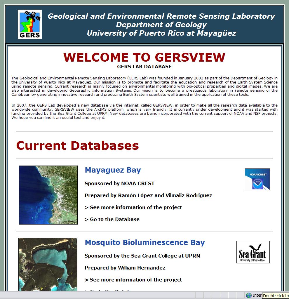
2 Geological and Environmental Remote Sensing Laboratory Department of Geology University of Puerto Rico at Mayaguez gers.uprm.edu


3 GERS Lab was founded in January 2002 with the mission of promoting and facilitating the education and research of the remote sensing tools applied to the Earth System Science. Our vision is to become a prestigious laboratory in remote sensing of the Caribbean Region by generating innovative research and producing Earth Scientists well trained in remote sensing applications.


4 Current research is mainly focus on environmental monitoring using biogeooptical properties, digital images, and Geographic Information Systems (GIS).


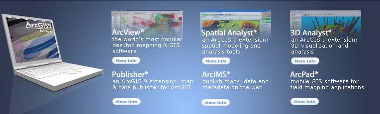

5 ArcGIS 9.3 Environmental Systems Research Institute, Inc. (ESRI)


6 ArcIMS ArcIMS 9.1 Scalable Extendable Organizational application Map distribution and geographic information system (GIS) data on the Internet. Create easy-to-use, taskfocused applications that use geographic content. Deliver dynamic maps and data via the Web. Share data with others to accomplish tasks. Now working in ArcIMS 9.3
7 Configuration at GERS Lab Configure Server Computer Install and Configure Supporting Software (Java 2SDK, Tomcat 5.028, and ISS 6.0) Install ArcIMS Create Projects in ArcView Create and Customize ArcIMS Web Application Publish Map Interface in the Web gersview.uprm.edu
8
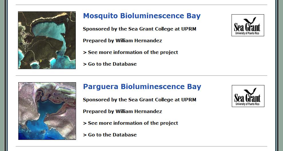
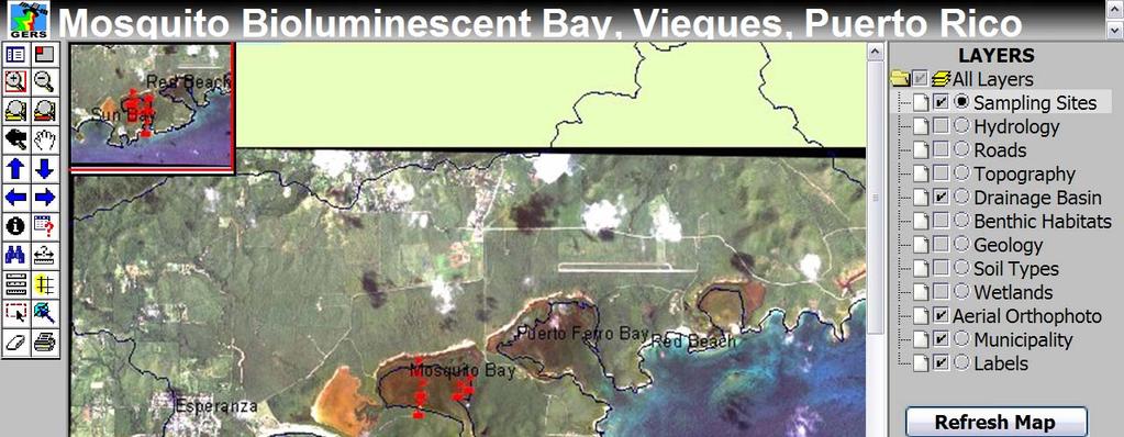
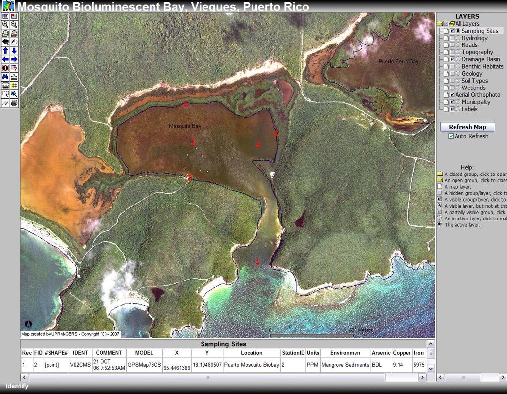
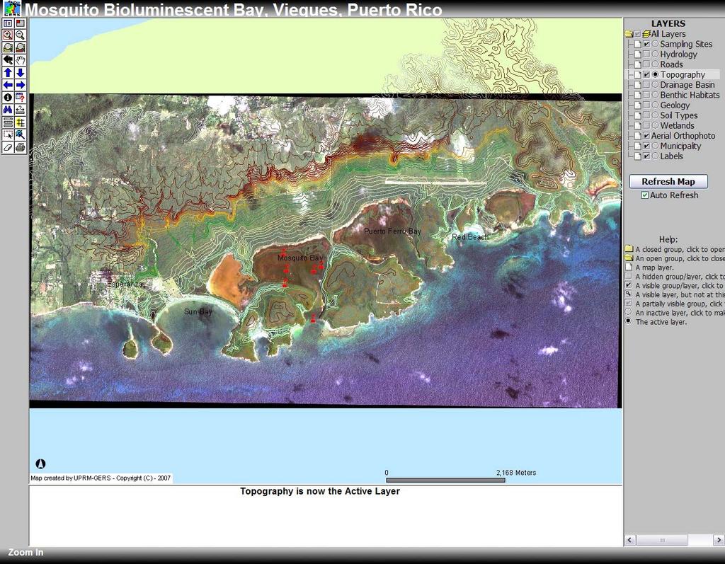
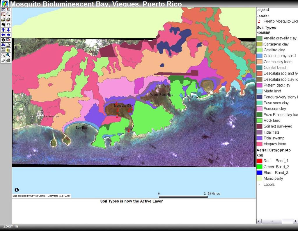
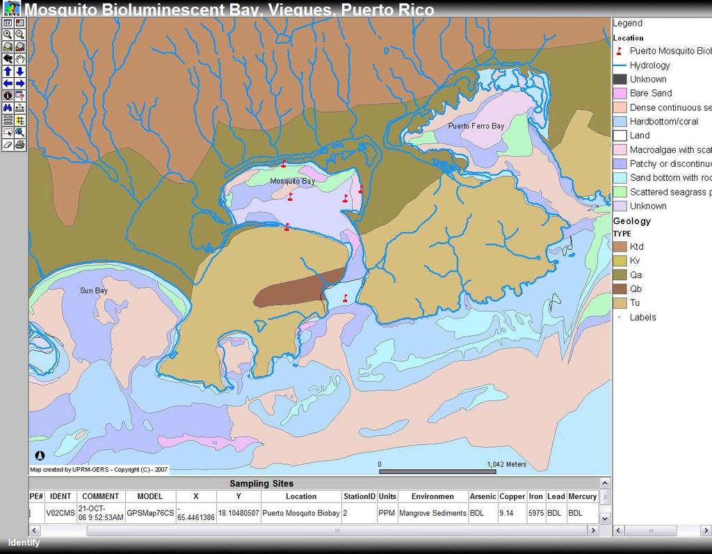
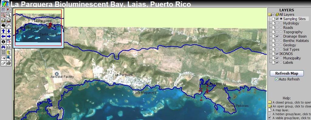
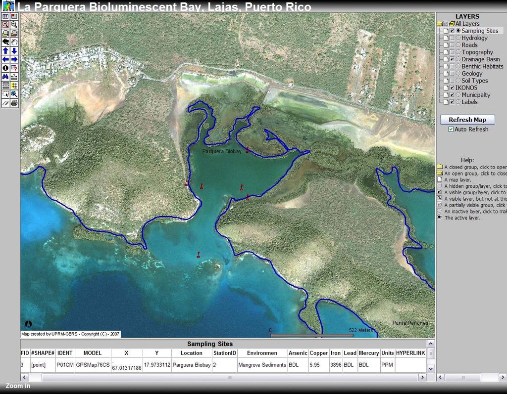
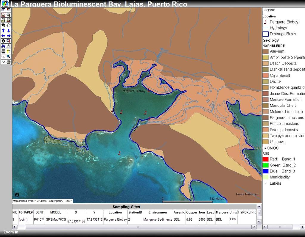
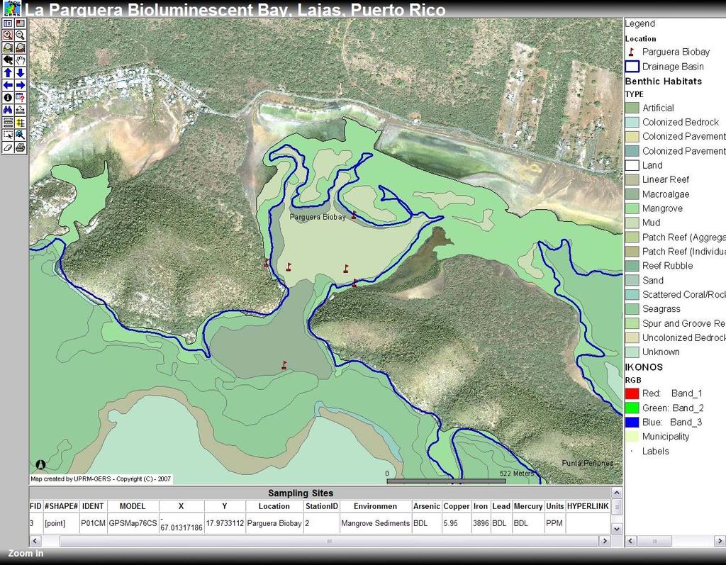
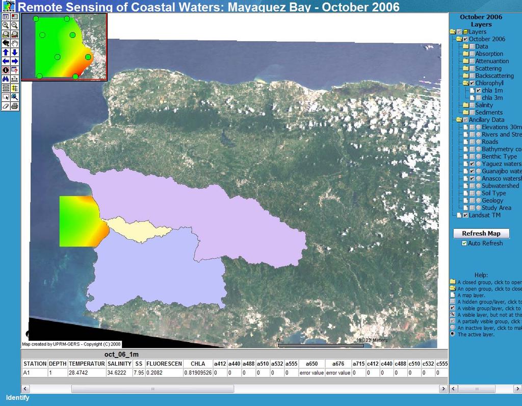
9 Database GIS Data Layers used for Biobays Map Projects Layers Description Source(s) Location Used Sampling Sites From heavy metals study GERS LAB Mosquito Bay, Parguera Bay Hydrology Surface hydrology USGS Mosquito Bay, Parguera Bay Roads Major roads JP, DTOP Mosquito Bay, Parguera Bay Topography Elevation contours USGS Mosquito Bay, Parguera Bay Drainage basin Delimiting drainage basin USGS, JP Mosquito Bay, Parguera Bay Benthic Habitats Benthic community types NOAA Mosquito Bay, Parguera Bay Geology Major geological feaures USGS Mosquito Bay, Parguera Bay Soil Types Soil Types and Series NRCS-USDA Mosquito Bay, Parguera Bay Wetlands Wetland features distribution USFWS Mosquito Bay, Parguera Bay Aerial Orthophotos Aerial Photography (2004) US-COI, NRCS-USDA Mosquito Bay IKONOS image Satellite imagery (2007??) UPRM-GERS Parguera Bay Municipality Puerto Rico Municipality name JP Mosquito Bay, Parguera Bay Labels Important Places UPRM-GERS Mosquito Bay, Parguera Bay Aerial Orthophotos Aerial Photography (1999) NOAA Parguera Bay
10
11
12
13
14
15
16
17
18
19
20


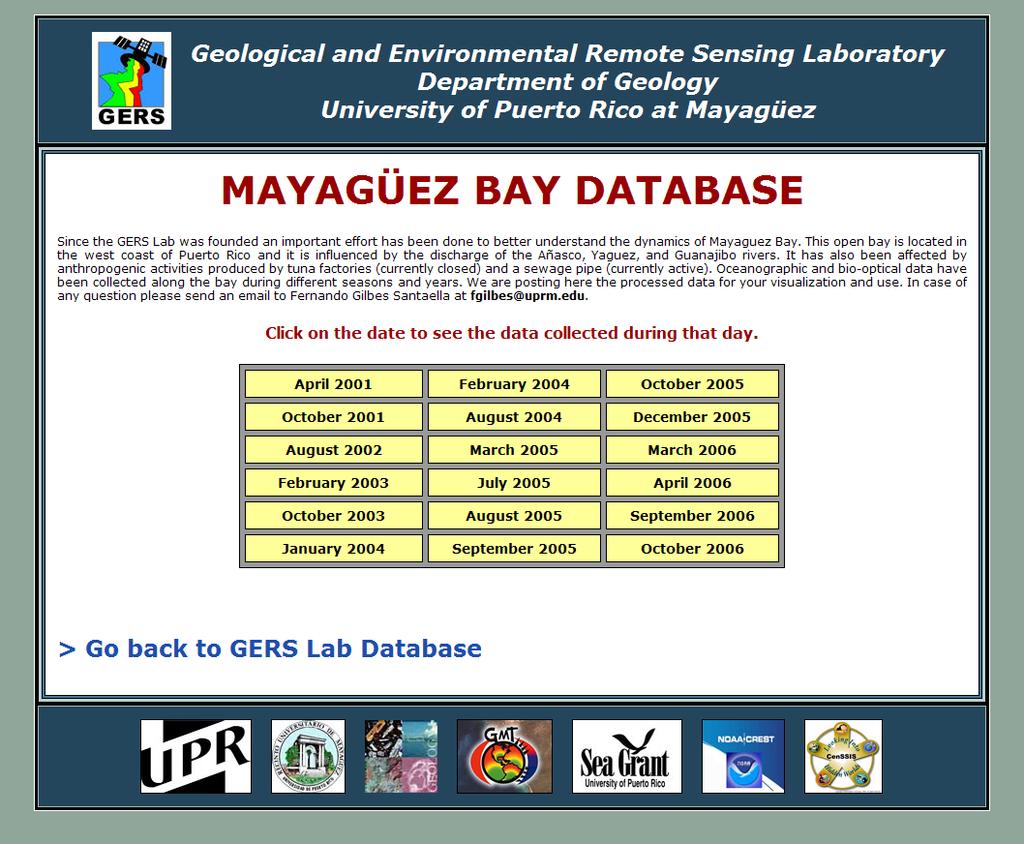
21 Study Area Study Period Date Stations Days Apr Oct Feb Aug Feb Oct Jan Feb Aug Mar Jul Aug Sept Oct Dec Mar Apr Sept Oct May Mar

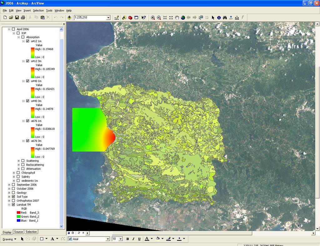
22 After all necessary corrections data was summarized into databases
23 TOTAL SUSPENDED SEDIMENTS 0.5 METERS 1.0 METERS
24
25
26


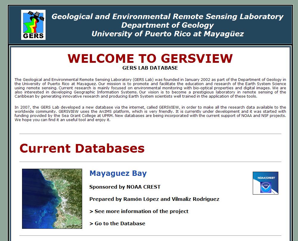
 GERSVIEW ArcIMS")

27 gersview.uprm.edu Current Projects Bioluminescence Bays Mayaguez Bay Watershed Future Projects Parguera Reefs Jobos Bay (Pending) GERSVIEW ArcIMS Mapping Interface Mapping Interface (World-Wide Users, Researchers) Database ArcView Info Projects


28 Conclusions GIS is an excellent tool for better understanding the dynamics of coastal environments. An important database has been accomplished and it is now published in the web for public used. Other databases of coastal environments and marine habitats of PR could be published using a similar system.
29 Next Steps Continue working with Mayaguez Bay database. Start working in a database of Coral Reefs. La Parguera Bio-optical database. Enhance HTML Viewer Hierarchical Table of Contents Hyperlinks, Graphics, etc. Enable Java Viewer Purchase a New Server Better storage and processing Upgrade to ArcIMS 9.3 Include RS imagery analysis products (ENVI).
30 Acknowledgements This work was sponsored by the University of Puerto Rico Sea Grant College Program and the NOAA Center for Cooperative Remote Sensing Science and Technology Center. The databases have been created by: William Hernandez Vilmaliz Rodriguez Ramon Lopez ArcIMS configuration was made by William Hernandez and GMT technical support.


31
GERSVIEW: A New Database for Web Mapping
 GERSVIEW: A New Database for Web Mapping William J. Hernández, M.S. Graduate Student Department of Marine Sciences-UPRM Fernando Gilbes, Ph.D. Associate Professor Department of Geology-UPRM Overview Introduction
Undergraduate Research Final Report: Estimation of suspended sediments using MODIS 250 m bands in Mayagüez Bay, Puerto Rico
 Undergraduate Research Final Report: Estimation of suspended sediments using MODIS 250 m bands in Mayagüez Bay, Puerto Rico Abstract: José F. Martínez Colón Undergraduate Research 2007 802-03-4097 Advisor:
Display data in a map-like format so that geographic patterns and interrelationships are visible
 Vilmaliz Rodríguez Guzmán M.S. Student, Department of Geology University of Puerto Rico at Mayagüez Remote Sensing and Geographic Information Systems (GIS) Reference: James B. Campbell. Introduction to
MAPPING THE FREQUENCY AND DISTRIBUTION OF THE RIO GRANDE DE AÑASCO PLUME USING MERIS
 MAPPING THE FREQUENCY AND DISTRIBUTION OF THE RIO GRANDE DE AÑASCO PLUME USING MERIS AS PART OF THE SEA GRANT PROJECT: APPLICATION OF THE SOIL AND WATER ASSESSMENT TOOL MODEL (SWAT) TO ESTIMATE DISCHARGE
SATELLITE DATA COLLECTION BY THE UPRM-TCESS SPACE INFORMATION LABORATORY
 SATELLITE DATA COLLECTION BY THE UPRM-TCESS SPACE INFORMATION LABORATORY Visita a la Estación De Satélites De UPRM En el CID 16 sep. 4:30 pm Nos reuniremos al frente del CID. CID L-BAND ANTENNA Orbview
Outline Introduction Objectives Study Area Methodology Result Discussion Conclusion
 Land Cover, Land Use of two bioluminescent bays in Puerto Rico Undergraduate Research By: Yadira Soto Viruet Advisor: Fernando Gilbes Santaella, Ph.D Outline Introduction Objectives Study Area Methodology
StreamStats: Delivering Streamflow Information to the Public. By Kernell Ries
 StreamStats: Delivering Streamflow Information to the Public By Kernell Ries U.S. Department of the Interior U.S. Geological Survey MD-DE-DC District 410-238-4317 kries@usgs.gov StreamStats Web Application
NR402 GIS Applications in Natural Resources
 NR402 GIS Applications in Natural Resources Lesson 1 Introduction to GIS Eva Strand, University of Idaho Map of the Pacific Northwest from http://www.or.blm.gov/gis/ Welcome to NR402 GIS Applications in
Web (Java, ArcGIS Server [WebADF, flex, silverlight]) Mobile (ArcGIS Mobile, ArcPad, Windows Mobile) Deskt
![Web (Java, ArcGIS Server [WebADF, flex, silverlight]) Mobile (ArcGIS Mobile, ArcPad, Windows Mobile) Deskt](/thumbs/96/129284052.jpg "Web (Java, ArcGIS Server [WebADF, flex, silverlight]) Mobile (ArcGIS Mobile, ArcPad, Windows Mobile) Deskt") GIS Services company in Lincoln, NE Custom GIS database design and build (for local, county, state and private corporations) Custom (ESRI and non-esri) application design and build in Java, C++, C#,.Net
GIS Services company in Lincoln, NE Custom GIS database design and build (for local, county, state and private corporations) Custom (ESRI and non-esri) application design and build in Java, C++, C#,.Net
NOAA s OCM: Services, tools and collaboration opportunities & Puerto Rico s NE Marine Corridor as a case study
 NOAA s OCM: Services, tools and collaboration opportunities & Puerto Rico s NE Marine Corridor as a case study Dr. Antares Ramos Álvarez NOAA s Office of Coastal Management September 15 th, 2016 Conservation
Seasonal variability in the vertical attenuation coefficient at 490 nm (K490) in waters around Puerto Rico and US Virgin Islands.
 in waters around Puerto Rico and US Virgin Islands.") Seasonal variability in the vertical attenuation coefficient at 490 nm (K490) in waters around Puerto Rico and US Virgin Islands. William J. Hernandez 1 and Fernando Gilbes 2 1 Department of Marine Science,
Seasonal variability in the vertical attenuation coefficient at 490 nm (K490) in waters around Puerto Rico and US Virgin Islands. William J. Hernandez 1 and Fernando Gilbes 2 1 Department of Marine Science,
High-resolution bottom albedo images and benthic habitat classification to develop baseline management tools in Natural Reserves
 High-resolution bottom albedo images and benthic habitat classification to develop baseline management tools in Natural Reserves William J. Hernandez, Ph.D. and Roy A. Arsmtrong, Ph.D. Post-Doctoral Researcher
Pierce Cedar Creek Institute GIS Development Final Report. Grand Valley State University
 Pierce Cedar Creek Institute GIS Development Final Report Grand Valley State University Major Goals of Project The two primary goals of the project were to provide Matt VanPortfliet, GVSU student, the
Information. Information Technology. Geographic. Services (GIS) 119 W Indiana Ave Deland, FL 32720
 119 W Indiana Ave Deland, FL 32720") Information Technology Geographic Information Services (GIS) 119 W Indiana Ave Deland, FL 32720 A GIS consists of 5 primary components: Hardware Software People Data Methods or Business Processes --- Hardware
Information Technology Geographic Information Services (GIS) 119 W Indiana Ave Deland, FL 32720 A GIS consists of 5 primary components: Hardware Software People Data Methods or Business Processes --- Hardware
GAMINGRE 8/1/ of 7
 FYE 09/30/92 JULY 92 0.00 254,550.00 0.00 0 0 0 0 0 0 0 0 0 254,550.00 0.00 0.00 0.00 0.00 254,550.00 AUG 10,616,710.31 5,299.95 845,656.83 84,565.68 61,084.86 23,480.82 339,734.73 135,893.89 67,946.95
Watershed Application of WEPP and Geospatial Interfaces. Dennis C. Flanagan
 Watershed Application of WEPP and Geospatial Interfaces Dennis C. Flanagan Research Agricultural Engineer USDA-Agricultural Research Service Adjunct Professor Purdue Univ., Dept. of Agric. & Biol. Eng.
High-resolution bottom albedo images and benthic habitat classification to develop baseline management tools in Natural Reserves
 High-resolution bottom albedo images and benthic habitat classification to develop baseline management tools in Natural Reserves *William J. Hernandez, Ph.D. and Roy A. Armstrong, Ph.D. *Post-Doctoral
University of Puerto Rico Mayagüez Campus Department of Geology
 University of Puerto Rico Mayagüez Campus Department of Geology Undergraduate Research Final Report: Development of a site-specific algorithm to estimate suspended sediments using MODIS José F. Martínez
Introduction to Geographic Information Systems (GIS): Environmental Science Focus
: Environmental Science Focus") Introduction to Geographic Information Systems (GIS): Environmental Science Focus September 9, 2013 We will begin at 9:10 AM. Login info: Username:!cnrguest Password: gocal_bears Instructor: Domain: CAMPUS
Introduction to Geographic Information Systems (GIS): Environmental Science Focus September 9, 2013 We will begin at 9:10 AM. Login info: Username:!cnrguest Password: gocal_bears Instructor: Domain: CAMPUS
Remote Sensing of Episodic Rainfall Events Affecting Coral Reefs in Southwestern Puerto Rico
 Remote Sensing of Episodic Rainfall Events Affecting Coral Reefs in Southwestern Puerto Rico Y. Detrés, R. Armstrong, E. Otero and R. García yasmin@cacique.uprm.edu University of Puerto Rico, Mayaguez
McHenry County Property Search Sources of Information
 Disclaimer: The information in this system may contain inaccuracies or typographical errors. The information in this system is a digital representation of information derived from original documents; as
Statewide Topographic Mapping Program
 Statewide Topographic Mapping Program February 28, 2018 www.dotd.la.gov Outline Purpose of the Statewide Topographic Mapping Program History Breakdown of R.S. 48:36 - Topographic Mapping Statewide Topographic
SRJC Applied Technology 54A Introduction to GIS
 SRJC Applied Technology 54A Introduction to GIS Overview Lecture of Geographic Information Systems Fall 2004 Santa Rosa Junior College Presented By: Tim Pudoff, GIS Coordinator, County of Sonoma, Information
SoilView: Development of a Custom GIS Application for Publishing Soil Surveys
 SoilView: Development of a Custom GIS Application for Publishing Soil Surveys Allan Johnson and Mike Wigginton Abstract Currently, digital soils information can be obtained from many sources. Numerous
Geospatial Data, Services, and Products. National Surveying, mapping and geospatial conference
 Geospatial Data, Services, and Products Federal Programs -- USDA NRCS National Surveying, mapping and geospatial conference March 15, 2016 NRCS Applications using Geosaptial Products & Services Field
An Internet-Based Integrated Resource Management System (IRMS)
") An Internet-Based Integrated Resource Management System (IRMS) Third Quarter Report, Year II 4/1/2000 6/30/2000 Prepared for Missouri Department of Natural Resources Missouri Department of Conservation
An Internet-Based Integrated Resource Management System (IRMS) Third Quarter Report, Year II 4/1/2000 6/30/2000 Prepared for Missouri Department of Natural Resources Missouri Department of Conservation
RHOAPS. Real-time Hydrology Ocean Atmosphere Prediction System. Pronunciation: Ropes Motto: More than just THREDDS
 RHOAPS Real-time Hydrology Ocean Atmosphere Prediction System Pronunciation: Ropes Motto: More than just THREDDS Key Aspects Integrated real-time data systems Atmospheric Hydrologic Coastal oceans Societal
ESRI educational site license in Bahir Dar University. Tegegn Molla Abebe Mengaw Geospatial Data and Technology Center, BDU
 ESRI educational site license in Bahir Dar University Tegegn Molla Abebe Mengaw Geospatial Data and Technology Center, BDU September, 2016 Mission, Vision Purpose and Values of the GDTC Mission of GDTC
DGS Digital Geologic Information Resource (DGIR) User Guide
 User Guide") DGS Digital Geologic Information Resource (DGIR) User Guide Developed by the Delaware Geological Survey. Revised January 2012. TABLE OF CONTENTS I. INTRODUCTION II. DGIR LAYOUT III. TOOLBARS IV. USING
DGS Digital Geologic Information Resource (DGIR) User Guide Developed by the Delaware Geological Survey. Revised January 2012. TABLE OF CONTENTS I. INTRODUCTION II. DGIR LAYOUT III. TOOLBARS IV. USING
Soil Erosion Calculation using Remote Sensing and GIS in Río Grande de Arecibo Watershed, Puerto Rico
 Soil Erosion Calculation using Remote Sensing and GIS in Río Grande de Arecibo Watershed, Puerto Rico Alejandra M. Rojas González Department of Civil Engineering University of Puerto Rico at Mayaguez.
Puerto Rico Tsunami Mitigation and Warning Program: Update and Future
 Puerto Rico Tsunami Mitigation and Warning Program: Update and Future Christa G. von Hillebrandt- Andrade, Puerto Rico Seismic Network, UPRM Aurelio Mercado Dept. Marine Sciences, UPRM Status in 1999,
Welcome to NR502 GIS Applications in Natural Resources. You can take this course for 1 or 2 credits. There is also an option for 3 credits.
 Welcome to NR502 GIS Applications in Natural Resources. You can take this course for 1 or 2 credits. There is also an option for 3 credits. The 1st credit consists of a series of readings, demonstration,
HYDROLOGIC AND WATER RESOURCES EVALUATIONS FOR SG. LUI WATERSHED
 HYDROLOGIC AND WATER RESOURCES EVALUATIONS FOR SG. LUI WATERSHED 1.0 Introduction The Sg. Lui watershed is the upper part of Langat River Basin, in the state of Selangor which located approximately 20
GEOGRAPHIC INFORMATION SYSTEMS AND IT SOLUTIONS FOR THE ENVIRONMENT
 GEOGRAPHIC INFORMATION SYSTEMS AND IT SOLUTIONS FOR THE ENVIRONMENT Mission We focus on Solutions is a worldwide operating business offering Geographic Information Systems and IT solutions to assist environmental
Introduction to Geographic Information Systems
 Introduction to Geographic Information Systems Lynn_Carlson@brown.edu 401-863-9917 The Environmental And Remote TecHnologies Lab MacMillan Hall, Room 105 http://www.brown.edu/research/earthlab/ Outline
GIS-Based Sediment Quality Database for the St. Louis River Area of Concern (AOC): Overview Presentations and Demonstration
: Overview Presentations and Demonstration") GIS-Based Sediment Quality Database for the St. Louis River Area of Concern (AOC): Overview Presentations and Demonstration Judy L. Crane 1 and Dawn E. Smorong 2 1 Minnesota Pollution Control Agency, St.
GIS-Based Sediment Quality Database for the St. Louis River Area of Concern (AOC): Overview Presentations and Demonstration Judy L. Crane 1 and Dawn E. Smorong 2 1 Minnesota Pollution Control Agency, St.
DATA APPLIANCE FOR ARCGIS
 DATA APPLIANCE FOR ARCGIS Data Appliance for ArcGIS Provides Access to Multi-Scale Basemaps Down to Medium Scale Levels Worldwide And Large Scale for Most of the World The Data Appliance includes Several
Stream Discharge and the Water Budget
 Regents Earth Science Unit 6: Water Cycle & Climate Name: Lab # Stream Discharge and the Water Budget Introduction: The United States Geological Survey (USGS) measures and publishes values for the daily
Introduction to the 176A labs and ArcGIS Purpose of the labs
 Introduction to the 176A labs and ArcGIS Purpose of the labs Acknowledgement: Slides by David Maidment, U Texas-Austin and Francisco Olivera (TAMU) Hands-on experience with a leading software package Introduction
Using IKONOS Images to Evaluate Coral Reefs in Low versus High Sedimentation Environments
 Using IKONOS Images to Evaluate Coral Reefs in Low versus High Sedimentation Environments David N. Cuevas Miranda Department of Marine Sciences, University of Puerto Rico at Mayagüez P.O. Box 908 Lajas,
EMERGENCY PLANNING IN NORTHERN ALGERIA BASED ON REMOTE SENSING DATA IN RESPECT TO TSUNAMI HAZARD PREPAREDNESS
 EMERGENCY PLANNING IN NORTHERN ALGERIA BASED ON REMOTE SENSING DATA IN RESPECT TO TSUNAMI HAZARD PREPAREDNESS Barbara Theilen-Willige Technical University of Berlin, Institute of Applied Geosciences Department
Sources of Imagery and GIS Data Layers (Last updated October 2005)
") Sources of Imagery and GIS Data Layers (Last updated October 2005) The question of where to find data is one often asked by beginners in precision agriculture and other geospatial projects. The following
Sources of Imagery and GIS Data Layers (Last updated October 2005) The question of where to find data is one often asked by beginners in precision agriculture and other geospatial projects. The following
Regional Centre for Mapping of Resources for Development (RCMRD), Nairobi, Kenya. Introduction GIS (2 weeks: 10 days)
, Nairobi, Kenya. Introduction GIS (2 weeks: 10 days)") Regional Centre for Mapping of Resources for Development (RCMRD), Nairobi, Kenya Introduction GIS (: 10 days) Intake Dates: 9 th Jan, 6 th Feb, 6 th Mar, 3 rd April, 8 th May, 5 th June, 3 rd July, 2017
Regional Centre for Mapping of Resources for Development (RCMRD), Nairobi, Kenya Introduction GIS (: 10 days) Intake Dates: 9 th Jan, 6 th Feb, 6 th Mar, 3 rd April, 8 th May, 5 th June, 3 rd July, 2017
OC Enterprise GIS. Kevin Hills, PLS Cameron Smith, GISP. OC Survey
 OC Enterprise GIS Kevin Hills, PLS Cameron Smith, GISP OC Survey Discussion Points Background & Organizational Structure of OCPW Past practices prior to Enterprise Wide GIS License (ELA) Participating
McHenry County Property Search Sources of Information
 Disclaimer: The information in this system may contain inaccuracies or typographical errors. The information in this system is a digital representation of information derived from original documents; as
Using MAGIC to Access Spatial Imagery: Putting ER Mapper Image Web Server, ArcIMS and MrSID to work in your Library
 Using MAGIC to Access Spatial Imagery: Putting ER Mapper Image Web Server, ArcIMS and MrSID to work in your Library Patrick McGlamery Shirley Quintero University of Connecticut Libraries Building the Connecticut
Digital Tax Maps Westport Island Project Summary
 Digital Tax Maps Westport Island Project Summary Presented to the: Mid-Coast Regional Planning Commission Creating GIS-Based Digital Tax Maps And Linked Assessment Records For Small Towns on a Budget Dennis
Integrated application of Land Surveying and Mappipng. Data on Web-GIS
 Integrated application of Land Surveying and Mappipng Data on Web-GIS Abstract The data system of the land surveying and drawing is the core of the land information system. It includes the following contents:
Hydrologic Modelling of the Upper Malaprabha Catchment using ArcView SWAT
 Hydrologic Modelling of the Upper Malaprabha Catchment using ArcView SWAT Technical briefs are short summaries of the models used in the project aimed at nontechnical readers. The aim of the PES India
Geospatial Technologies for the Agricultural Sciences
 Geospatial Technologies for the Agricultural Sciences Maggi Kelly Assoc. Cooperative Extension Specialist Department of Environmental Science, Policy & Management Director, GIIF UC Berkeley Karin Tuxen
Flood Database for Oklahoma: A web-mapping application for spatial data organization and access
 Flood Database for Oklahoma: A web-mapping application for spatial data organization and access Developed in partnership with the Oklahoma Department of Transportation Bridge and Survey Divisions S. Jerrod
4. GIS Implementation of the TxDOT Hydrology Extensions
 4. GIS Implementation of the TxDOT Hydrology Extensions A Geographic Information System (GIS) is a computer-assisted system for the capture, storage, retrieval, analysis and display of spatial data. It
WIND EFFECTS ON CHEMICAL SPILL IN ST ANDREW BAY SYSTEM
 WIND EFFECTS ON CHEMICAL SPILL IN ST ANDREW BAY SYSTEM PETER C. CHU, PATRICE PAULY Naval Postgraduate School, Monterey, CA93943 STEVEN D. HAEGER Naval Oceanographic Office, Stennis Space Center MATHEW
Imagery and the Location-enabled Platform in State and Local Government
 Imagery and the Location-enabled Platform in State and Local Government Fred Limp, Director, CAST Jim Farley, Vice President, Leica Geosystems Oracle Spatial Users Group Denver, March 10, 2005 TM TM Discussion
Aerial Photography and Imagery Resources Guide
 Aerial Photography and Imagery Resources Guide Cheyenne and Laramie County Cooperative GIS Created and Maintained by the GIS Coordinator for the Cooperative GIS Program May 2016 CHEYENNE / LARAMIE COUNTY
5th Caribbean Environmental Forum and Exhibition (CEF 5) Montego Bay, Jamaica June 21-25, 2010
 Montego Bay, Jamaica June 21-25, 2010") 5th Caribbean Environmental Forum and Exhibition (CEF 5) Montego Bay, Jamaica June 21-25, 2010 Watershed Modeling in the Caribbean: Application of Geographic Information Systems (GIS) in the Assessment
5th Caribbean Environmental Forum and Exhibition (CEF 5) Montego Bay, Jamaica June 21-25, 2010 Watershed Modeling in the Caribbean: Application of Geographic Information Systems (GIS) in the Assessment
Changing Hydrology under a Changing Climate for a Coastal Plain Watershed
 Changing Hydrology under a Changing Climate for a Coastal Plain Watershed David Bosch USDA-ARS, Tifton, GA Jeff Arnold ARS Temple, TX and Peter Allen Baylor University, TX SEWRU Objectives 1. Project changes
Techniques for Science Teachers: Using GIS in Science Classrooms.
 Techniques for Science Teachers: Using GIS in Science Classrooms. After ESRI, 2008 GIS A Geographic Information System A collection of computer hardware, software, and geographic data used together for
Web-enabled GIS Services
 Austin Davis Research Geographer US Army Engineer Research and Development Center, Environmental Laboratory (EL) Waterways Experiment Station (WES), Vicksburg, Mississippi Environmental Systems Branch
an accessible interface to marine environmental data Russell Moffitt
 an accessible interface to marine environmental data Russell Moffitt The Atlas Project GOAL: To provide a single point of access to oceanographic and environmental data for use by marine resource researchers,
Home About Us Articles Press Releases Image Gallery Contact Us Media Kit Free Subscription 10/5/2006 5:56:35 PM
 Home About Us Articles Press Releases Image Gallery Contact Us Media Kit Free Subscription 10/5/2006 5:56:35 PM Industry Resources Industry Directory NASA Links Missions/Launches Calendar Human development
Lecture 12. Data Standards and Quality & New Developments in GIS
 Lecture 12 Data Standards and Quality & New Developments in GIS Lecture 12: Outline I. Data Standards and Quality 1. Types of Spatial Data Standards 2. Data Accuracy 3. III. Documenting Spatial Data Accuracy
Utah UIC Geospatial Integration EIEN Project
 Utah UIC Geospatial Integration EIEN Project ESRI UC, June 2007 Bert Granberg Utah Automated Geographic Reference Center Utah Automated Geographic Reference Center (AGRC) AGRC Responsibilities Facilitate
SEAWIFS VALIDATION AT THE CARIBBEAN TIME SERIES STATION (CATS)
") SEAWIFS VALIDATION AT THE CARIBBEAN TIME SERIES STATION (CATS) Jesús Lee-Borges* and Roy Armstrong Department of Marine Science, University of Puerto Rico at Mayagüez, Mayagüez, Puerto Rico 00708 Fernando
SEAWIFS VALIDATION AT THE CARIBBEAN TIME SERIES STATION (CATS) Jesús Lee-Borges* and Roy Armstrong Department of Marine Science, University of Puerto Rico at Mayagüez, Mayagüez, Puerto Rico 00708 Fernando
Introduction to the 176A labs and ArcGIS
 Introduction to the 176A labs and ArcGIS Acknowledgement: Slides by David Maidment, U Texas-Austin and Francisco Olivera (TAMU) Purpose of the labs Hands-on experience with one software pakage Introduction
Faculty Instructor and Associate in Research Duke University Phone: Nicholas School of the Environment Fax:
 Peter Harrell Faculty Instructor and Associate in Research Duke University Phone: 919-613-8127 Nicholas School of the Environment Fax: 919-684-8741 PO Box 90287 Peter.Harrell@duke.edu Durham, NC 27708
Geometric Algorithms in GIS
 Geometric Algorithms in GIS GIS Visualization Software Dr. M. Gavrilova GIS Software for Visualization ArcView GEO/SQL Digital Atmosphere AutoDesk Visual_Data GeoMedia GeoExpress CAVE? Visualization in
CHAPTER 22 GEOGRAPHIC INFORMATION SYSTEMS
 CHAPTER 22 GEOGRAPHIC INFORMATION SYSTEMS PURPOSE: This chapter establishes the administration and use of to improve the quality and accessibility of Department s spatial information and support graphical
Using GIS to Delineate Watersheds Ed Poyer NRS 509, Fall 2010
 Using GIS to Delineate Watersheds Ed Poyer NRS 509, Fall 2010 A watershed is an area that contributes flow to a point on the landscape. (Bolstad, 2005). Watersheds are an important focus of study because
SWAMP GIS: A spatial decision support system for predicting and treating stormwater runoff. Michael G. Wing 1 * and Derek Godwin
 Journal of Spatial Hydrology Vol. 11, No. 2 Fall 2011 SWAMP GIS: A spatial decision support system for predicting and treating stormwater runoff Michael G. Wing 1 * and Derek Godwin Abstract SWAMP GIS
Lecture 11. Data Standards and Quality & New Developments in GIS
 Lecture 11 Data Standards and Quality & New Developments in GIS Lecture 11: Outline I. Data Standards and Quality 1. Types of Spatial Data Standards 2. Data Accuracy II. New Developments/The Future of
GIS at UCAR. The evolution of NCAR s GIS Initiative. Olga Wilhelmi ESIG-NCAR Unidata Workshop 24 June, 2003
 GIS at UCAR The evolution of NCAR s GIS Initiative Olga Wilhelmi ESIG-NCAR Unidata Workshop 24 June, 2003 Why GIS? z z z z More questions about various climatological, meteorological, hydrological and
Geo-spatial Analysis for Prediction of River Floods
 Geo-spatial Analysis for Prediction of River Floods Abstract. Due to the serious climate change, severe weather conditions constantly change the environment s phenomena. Floods turned out to be one of
ICAN Great Lakes Workshop
 Washington Coastal latlas ICAN Great Lakes Workshop September 13 15, 15 2010 Current Washington Coastal Atlas http://www.ecy.wa.gov/programs/sea/sma/atlas_home.html 1 st version of WA Coastal Atlas was
Esri Image & Mapping Forum 9 July 2017 Geiger-Mode for Conservation Planning & Design by USDA NRCS NGCE
 Esri Image & Mapping Forum 9 July 2017 Geiger-Mode for Conservation Planning & Design by USDA NRCS NGCE For over 75 years, the Natural Resources Conservation Service has been a pioneer in conservation,
Improvement of the National Hydrography Dataset for US Forest Service Region 3 in Cooperation with the National Forest Service
 Improvement of the National Hydrography Dataset for US Forest Service Region 3 in Cooperation with the National Forest Service Christian L. DeCasas California State University, Northridge November 7 th,
Summary Description Municipality of Anchorage. Anchorage Coastal Resource Atlas Project
 Summary Description Municipality of Anchorage Anchorage Coastal Resource Atlas Project By: Thede Tobish, MOA Planner; and Charlie Barnwell, MOA GIS Manager Introduction Local governments often struggle
Joanne N. Halls, PhD Dept. of Geography & Geology David Kirk Information Technology Services
 Joanne N. Halls, PhD Dept. of Geography & Geology David Kirk Information Technology Services Geographic Information Systems manage and analyze data to solve spatial problems. Real World Abstraction Analysis
Creation of an Internet Based Indiana Water Quality Atlas (IWQA)
") Department of Environmental Management Creation of an Internet Based Water Quality Atlas (IWQA) May 4, 2005 IUPUI 1200 Waterway Blvd., Suite 100 polis, 46202-5140 Water Quality Atlas John Buechler, Neil
Department of Environmental Management Creation of an Internet Based Water Quality Atlas (IWQA) May 4, 2005 IUPUI 1200 Waterway Blvd., Suite 100 polis, 46202-5140 Water Quality Atlas John Buechler, Neil
Aerial Photography and Imagery Resources Guide
 Aerial Photography and Imagery Resources Guide Cheyenne and Laramie County Cooperative GIS Created and Maintained by the GIS Coordinator for the Cooperative GIS Program March 2011 CHEYENNE / LARAMIE COUNTY
Mapping Your Land and Introduction to Web Soil Survey. Elizabeth Cook GIS Specialist USDA-NRCS (retired)
") Mapping Your Land and Introduction to Web Soil Survey Elizabeth Cook GIS Specialist USDA-NRCS (retired) Using Geographic Information Systems (GIS), Global Positioning System (GPS), digital aerial photography
Mapping Your Land and Introduction to Web Soil Survey Elizabeth Cook GIS Specialist USDA-NRCS (retired) Using Geographic Information Systems (GIS), Global Positioning System (GPS), digital aerial photography
Watershed statistics viewer
 Core Global or Geo-Spatial Databases (CGDB) FAO-SDRN Poverty Mapping Project Group (PMPG) United Nations Geographic Information Working Group (UNGIWG) Broader Geo-Spatial User Community An Inventory and
GIS-T 2010 Building a Successful Geospatial Data Sharing Framework: A Ohio DOT Success Story
 GIS-T 2010 Building a Successful Geospatial Data Sharing Framework: A Ohio DOT Success Story ODOT District 2 GIS John Puente District 1 GIS Coordinator\ Planning Administrator 2 Interoperability 3 District
Introduction to GIS. Geol 4048 Geological Applications of Remote Sensing
 Introduction to GIS Geol 4048 Geological Applications of Remote Sensing GIS History: Before Computers GIS History Using maps for a long time Dr. Roger F. Tomlinson Father of GIS He was an English geographer
Geographic Information Systems Tools for Collecting and Accessing Arctic Bathymetry: International Bathymetric Chart of the Arctic Ocean
 University of New Hampshire University of New Hampshire Scholars' Repository Center for Coastal and Ocean Mapping Center for Coastal and Ocean Mapping 1-22-2001 Geographic Information Systems Tools for
Developing a protocol to use remote sensing as a cost effective tool to monitor contamination of mangrove wetlands
 Developing a protocol to use remote sensing as a cost effective tool to monitor contamination of mangrove wetlands Johannes H. Schellekens, Fernando Gilbes-Santaella, Augustine Rodriguez-Roman, and Belyneth
Date of Report: EPA agreement number: Center Name and Institution of Ctr. Director: Identifier used by Center for Project: Title of Project:
 Date of Report: March 31, 2003 EPA agreement number: R829515C003 Center Name and Institution of Ctr. Director: Rocky Mountain Regional Hazardous Substance Research Center, Colorado State University, Fort
SOLUTIONS ADVANCED GIS. TekMindz are developing innovative solutions that integrate geographic information with niche business applications.
 ADVANCED GIS SOLUTIONS TekMindz are developing innovative solutions that integrate geographic information with niche business applications. TEK INDZ TM GIS Services Overview At the leading edge of geospatial
Geospatial Decision Support Tools for Planning of Marine Protected Areas in California
 Geospatial Decision Support Tools for Planning of Marine Protected Areas in California WILL MCCLINTOCK (UNIVERSITY OF CALIFORNIA SANTA BARBARA), MATT MERRIFIELD (THE NATURE CONSERVANCY), SOPHIE DE BEUKELAER
PUBLIC OUTREACH THROUGH GIS
 PUBLIC OUTREACH THROUGH GIS Tim Witt, Department of Earth Sciences, University of South Alabama, Mobile, AL 36688. E-mail: tw501@jaguar1.usouthal.edu. In this paper, I propose a few ways, by using GIS
ANDREW MCMILLAN 888 West 18 th Avenue Vancouver, BC V5Z 1W3 Tel. (604) OBJECTIVE SUMMARY
 OBJECTIVE SUMMARY") ANDREW MCMILLAN 888 West 18 th Avenue Vancouver, BC V5Z 1W3 Tel. (604) 877-1802 Email: ajmcmillan@yahoo.ca OBJECTIVE To provide and manage IT, spatial solutions and web technologies using strong problem
ANDREW MCMILLAN 888 West 18 th Avenue Vancouver, BC V5Z 1W3 Tel. (604) 877-1802 Email: ajmcmillan@yahoo.ca OBJECTIVE To provide and manage IT, spatial solutions and web technologies using strong problem
An Internet-based Agricultural Land Use Trends Visualization System (AgLuT)
") An Internet-based Agricultural Land Use Trends Visualization System (AgLuT) Prepared for Missouri Department of Natural Resources Missouri Department of Conservation 07-01-2000-12-31-2001 Submitted by
An Internet-based Agricultural Land Use Trends Visualization System (AgLuT) Prepared for Missouri Department of Natural Resources Missouri Department of Conservation 07-01-2000-12-31-2001 Submitted by
Geospatial Data Sources. SLO GIS User Group June 8, 2010
 Geospatial Data Sources SLO GIS User Group June 8, 2010 Presenters Drew Decker USGS Southern California Geospatial Liaison Kelly Bobbitt Mike Bobbitt & Associates Joe Larson Cal Fire Peter Meertens Regional
A Post Processing Tool to Assess Sediment and Nutrient Source Allocations from SWAT Simulations
 A Post Processing Tool to Assess Sediment and Nutrient Source Allocations from SWAT Simulations Michael Van Liew William Puknat Montana Department of Environmental Quality Helena, Montana, USA PROBLEM:
Activities in Support of the Hurricane Mitch Reconstruction Program
 Activities in Support of the Hurricane Mitch Reconstruction Program U.S. Geological Survey Executive Summary March 2002 Overview: As part of the U.S. Government s program to assist Central America in the
Introduction-Overview. Why use a GIS? What can a GIS do? Spatial (coordinate) data model Relational (tabular) data model
 data model Relational (tabular) data model") Introduction-Overview Why use a GIS? What can a GIS do? How does a GIS work? GIS definitions Spatial (coordinate) data model Relational (tabular) data model intro_gis.ppt 1 Why use a GIS? An extension
Introduction-Overview Why use a GIS? What can a GIS do? How does a GIS work? GIS definitions Spatial (coordinate) data model Relational (tabular) data model intro_gis.ppt 1 Why use a GIS? An extension
Applied Cartography and Introduction to GIS GEOG 2017 EL. Lecture-2 Chapters 3 and 4
 Applied Cartography and Introduction to GIS GEOG 2017 EL Lecture-2 Chapters 3 and 4 Vector Data Modeling To prepare spatial data for computer processing: Use x,y coordinates to represent spatial features
Applications of Map Book Software for Local Government Agencies. Melisa Bowman Lincoln Parish GIS
 Applications of Map Book Software for Local Government Agencies Melisa Bowman Lincoln Parish GIS North Central Louisiana Parish 472 Square Miles Population: 42,000 Ruston: Largest Municipality Home to
GIS Geographical Information Systems
 Chapter Two GIS Geographical Information Systems Chapter Two GIS Geographical Information Systems Chapter Two GIS (Geographical Information Systems) 2.1 Introduction In most cases of our day life, information
National Hydrography Dataset (NHD) Update Project for US Forest Service Region 3
 Update Project for US Forest Service Region 3") National Hydrography Dataset (NHD) Update Project for US Forest Service Region 3 Allison Moncada California State University, Northridge February 2017 July 2017 Advisor: Joel Osuna Center for Geographical
National Hydrography Dataset (NHD) Update Project for US Forest Service Region 3 Allison Moncada California State University, Northridge February 2017 July 2017 Advisor: Joel Osuna Center for Geographical