Wetlands and Riparian Mapping Framework Technical Meeting
|
|
|
- Amy Iris Garrett
- 5 years ago
- Views:
Transcription

1 Wetlands and Riparian Mapping Framework Technical Meeting Meghan Burns Landscape Ecologist Linda Vance Senior Ecologist
2 Why wetland and riparian mapping? Preliminary site assessment for the presence of wetlands Facility and transportation/corridor siting Conservation incentive programs NAWCA grants Tribal wetland protection ordinances Restoration planning Conservation area planning? Fisheries protection? Floodplain management? Water quality protection? TMDLs and watershed plans? Watershed restoration? Plant and wildlife survey stratification
3 NWI - National Wetland Inventory The NWI was started in the 1970s with a mandate to provide a seamless map of all wetlands in the coterminous United States; In 1986, the Emergency Wetlands Resources Act required that these maps be available in digital format. As of 2008, digital maps of wetlands are only available for about 60% of the country. Montana is one of the states with incomplete mapping. To address this shortcoming, the MTNHP started the Montana Wetland and Riparian Mapping Center, with support from MT DEQ and the US EPA. Wetlands are one of thirteen framework layers in the Montana Spatial Data Infrastructure
4 Wetland Mapping Status With funding from the EPA, USFWS, BLM, USFS, USFWS, MTDOJ, MTDOA, MTFWP and PPL-MT we have mapped 581 1:24k USGS Quads
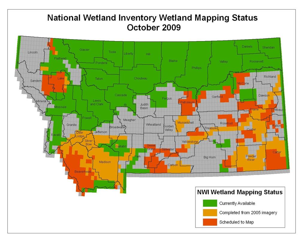
5
6 Old vs New NWI ACCURACY: The old NWI was inked on coarse scale aerial photographs then digitized, with very limited field checking; new NWI is based on 1meter resolution photos and an extensive foundation of ancillary GIS data, and has much more field checking. DETAIL: The old NWI mapped only wetlands, and used only the Cowardin classification system; the new NWI includes riparian areas as well, and incorporates an additional classification reflecting hydrogeomorphic attributes.

7 Old Mapping (1980s)
8 New Mapping
9 Old vs. new NWI: Detail PABF R3USA PABF PABF R2USA PEMF PABF PUBFx PEMF Rp1SS PEMC R3USA PABFx Rp1EM PABFx Rp1EM PABFx PABF PSSA R3USA PABFx Rp1EM Rp1SS Rp1SS PSSA R3USA R3USA Rp1EM Rp1SS Rp1EM R2UBH PSSA R2USC Rp1EM Rp1EM Rp1EM PSSA R2USC Rp1SS R3UBH R3USA R3USA Rp1SS PABF R3USA R2USA PABF PABFh R3USA R3USA Rp1SS R2UBF PABF R2USA Rp1SS PSSA


10 PEMB,, PSSA, PABF, R2USA, Rp1EM? NWI Coding: What does it mean? NWI uses three classes of wetlands: Palustrine, Riverine, and Lacustrine. All riparian systems are Rp. Some have subclasses: R3 is Riverine Upper Perennial; R2 is Riverine Lower Perennial The middle letters describe the vegetation: Emergent, or Shrub-Scrub, or Aquatic Bed The last letters describe the water regime: A is temporarily flooded, B is saturated, C is seasonally flooded, F is semipermanently flooded, etc.

11 Hydrogeomorphic Code includes: Waterbody Landform Flowpath Based on geomorphic setting, water source, and hydrodynamics Describes position on landscape Links wetland type with wetland function HGM defined

12 Wetlands perform various functions -water storage -stream flow maintenance -groundwater recharge -nutrient cycling -sediment retention -shoreline stabilization -terrestrial and aquatic habitat -flood mitigation -native plant community maintenance
13 Where is NWI data available now? The USFWS has 1980s era-maps, plus some recent maps (the Bitterroot Valley) on its website at Download as geodatabase Available as Web Mapping Service View and Download with Wetlands Online Mapper View in Google Earth maps do not include riparian mapping Available from NRIS at s mapping and some new mapping
14 NWI availability in the future? MTNHP will be making the new NWI maps with riparian mapping available as areas are completed Ideas for serving the data include: Web Mapping Application similar to tracker Web Mapping Service Downloadable georeferenced maps Web report with Wetland Profile

15 What is a Wetland Profile? Wetland landscape profiling describe the types, abundance and distribution of wetlands across a defined area It offers a rapid characterization of function and condition in a given subbasin or watershed, and help pinpoint management needs, including mitigation planning and conservation
16 Wetland Landscape Profile: Distribution of wetlands This profile of the Ruby River subbasin shows the density of wetlands in a given subwatershed (6 th code hydrologic units).
 that have been diked, dammed, ditched or")
17 Wetland Landscape Profile: Altered wetlands This profile of the Ruby River subbasin shows the percent of wetlands in a given subwatershed (6 th code hydrologic units) that have been diked, dammed, ditched or excavated.
18 Wetland Landscape Profile: Percent of isolated wetlands This profile of the Ruby River subbasin shows the percent of wetlands in a given subwatershed (6 th code hydrologic units) that are geographically isolated.
19 Linking wetland location with condition DEQ s Strategic Direction #3: Mapping, Assessment, and Monitoring MTNHP is using wetland mapping in a rotating basin assessment strategy Randomly select wetlands to conduct Level 1, 2, and 3 assessments Level 1 is a GIS-based landscape scale condition assessment Level 2 and 3 are field-based assessments
20 Rotating Basin Wetland Assessments Conducted first assessment in Milk-Marias basins this summer 2009 using historic NWI wetland mapping Finishing wetland mapping in SW Montana and will conduct second rotating basin assessment in 2010 Completing mapping in SE Montana in preparation for a third rotating basin assessment in 2011
21 What if my area isn t mapped or scheduled for mapping?
22 Several options for commissioning maps Geospatial Services of St. Mary s University of Minnesota will digitize 1980s era maps for $400- $500 a quad; The MTNHP will enter into mapping contracts for new maps based on new imagery; we can also create maps of valley bottoms and can make Zone A floodplain maps if H & H data is available. Private GIS consultants can use the same methods to interpret the same imagery, and can submit them to the NWI for approval.
23 Funding resources for NWI Maps The US EPA s Wetland Program Development Grants will not fund mapping as such, but will fund mapping in support of other watershed and wetland program building; Wetlands are one of thirteen GIS themes in the Montana Spatial Data Infrastructure, and funds to support wetland mapping are available to counties and conservation districts through the annual Montana Land Cover Information Act grant competition; Federal and state agencies, private corporations, and nonprofits have formed partnerships to get large areas mapped.
24 Next Steps? How can we make the NWI layer more accessible and useful? What information do we need to provide for better understanding? How should we package the data?


25 MORE INFORMATION: Meghan Burns (406) Linda Vance (406)
Wetland and Riparian Mapping: An Overview of the Montana Program
 Wetland and Riparian Mapping: An Overview of the Montana Program Meghan Burns, Catherine McIntyre, Karen Newlon Ecology Program Montana Natural Heritage Program Helena, MT Montana Natural Heritage Program
Wetland Mapping & Functional Assessment Canadian River Watershed New Mexico. Association of State Wetland Managers
 Wetland Mapping & Functional Assessment Canadian River Watershed New Mexico Association of State Wetland Managers November, 2012 Approach for this project based on: EPA 2006 Document: Application of Elements
Appendix E: Cowardin Classification Coding System
 Appendix E: Cowardin Classification Coding System The following summarizes the Cowardin classification coding system and the letters and numbers used to define the USFWS NWI wetland types and subtypes:
Use of Remote Sensing and GIS for Wetland, Riparian, and Watershed Assessment, Restoration, and Monitoring
 Use of Remote Sensing and GIS for Wetland, Riparian, and Watershed Assessment, Restoration, and Monitoring Ralph Tiner Wetland Ecologist U.S. Fish & Wildlife Service National Wetlands Inventory Program
National Wetlands Inventory Update for New England 2009
 National Wetlands Inventory Update for New England 2009 Ralph Tiner Wetland Ecologist U.S. Fish & Wildlife Service National Wetlands Inventory Program Where we ve been Maps Status and trends investigations
National Wetland Inventory
 Photo Interpretation Guide For Updating The National Wetland Inventory In Minnesota August 2011 National Wetland Inventory Introduction 1.1 Purpose of Photo Interpretation Guide 1 1.2 Contact information
Developing a Landscape-Level Reference Standard Wetland Profile for the Prairie Pothole Region, Montana
 Developing a Landscape-Level Reference Standard Wetland Profile for the Prairie Pothole Region, Montana Prepared for: The U.S. Environmental Protection Agency Prepared by: Melissa Hart and Linda Vance
Wetland & Floodplain Functional Assessments and Mapping To Protect and Restore Riverine Systems in Vermont. Mike Kline and Laura Lapierre Vermont DEC
 Wetland & Floodplain Functional Assessments and Mapping To Protect and Restore Riverine Systems in Vermont Mike Kline and Laura Lapierre Vermont DEC NWI+ Hydro-Geomorphic Characterization of Wetlands and
MONTANA NATURAL HERITAGE PROGRAM WETLAND PROGRAM PLAN
 MONTANA NATURAL HERITAGE PROGRAM WETLAND PROGRAM PLAN CREATING COMPREHENSIVE WETLANDS MAPPING, TOOLS, AND SCIENCE-BASED INFORMATION FOR MONTANA S PRIVATE AND PUBLIC WETLAND COMMUNITY PLANNING YEARS 2016-2020
A Comprehensive Inventory of the Number of Modified Stream Channels in the State of Minnesota. Data, Information and Knowledge Management.
 A Comprehensive Inventory of the Number of Modified Stream Channels in the State of Minnesota Data, Information and Knowledge Management Glenn Skuta Environmental Analysis and Outcomes Division Minnesota
DRY LAND APPROVED JURISDICTIONAL DETERMINATION FORM 1 U.S.
 DRY LAND APPROVED JURISDICTIONAL DETERMINATION FORM 1 U.S. Army Corps of Engineers This form should be completed by following the instructions provided in Section IV of the JD Form Instructional Guidebook.
ROAD SEDIMENT ASSESSMENT & MODELING: KOOTENAI-FISHER TMDL PLANNING AREA ROAD GIS LAYERS & SUMMARY STATISTICS
 ROAD SEDIMENT ASSESSMENT & MODELING: KOOTENAI-FISHER TMDL PLANNING AREA ROAD GIS LAYERS & SUMMARY STATISTICS Prepared by: ATKINS Water Resources Group 820 North Montana Avenue Helena, MT 59601 November
Southern California Coastal Water Research Project. Sharon De Leon. California State University Northridge. June 19, May 2013
 Southern California Coastal Water Research Project Sharon De Leon California State University Northridge June 19, 2012- May 2013 Shawna Dark, Center of Geographical Studies, California State University
The Refugia Concept: Using Watershed Analysis to Prioritize Salmonid Habitat for Conservation and Restoration
 The Refugia Concept: Using Watershed Analysis to Prioritize Salmonid Habitat for Conservation and Restoration Christopher May Battelle & UW Cumulative Impacts of Urbanization Landscape Alterations Loss
Birch Creek Geomorphic Assessment and Action Plan
 Birch Creek Geomorphic Assessment and Action Plan Jim Webster Tim Hanrahan, PhD, CFM Jesse Schwartz, PhD Zach Hill January 22, 2015 White Eagle Grange This Project is a First Step in Strategy Planning
Vegetation and Wildlife Habitat Mapping Study in the Upper and Middle Susitna Basin Study Plan Section 11.5
 (FERC No. 14241) Vegetation and Wildlife Habitat Mapping Study in the Upper and Middle Susitna Basin Study Plan Section 11.5 Initial Study Report Part C: Executive Summary and Section 7 Prepared for Prepared
Wetland Mapping. Wetland Mapping in the United States. State Wetland Losses 53% in Lower US. Matthew J. Gray University of Tennessee
 Wetland Mapping Caribbean Matthew J. Gray University of Tennessee Wetland Mapping in the United States Shaw and Fredine (1956) National Wetlands Inventory U.S. Fish and Wildlife Service is the principle
Distinct landscape features with important biologic, hydrologic, geomorphic, and biogeochemical functions.
 1 Distinct landscape features with important biologic, hydrologic, geomorphic, and biogeochemical functions. Have distinguishing characteristics that include low slopes, well drained soils, intermittent
The Evolution of NWI Mapping and How It Has Changed Since Inception
 The Evolution of NWI Mapping and How It Has Changed Since Inception Some Basic NWI Facts: Established in 1974 Goal to create database on characteristics and extent of U.S. wetlands Maps & Statistics In
USGS Hydrography Overview. May 9, 2018
 + 1 USGS Hydrography Overview May 9, 2018 + 2 The National Geospatial Program Provides the geospatial baseline of the Nation s topography, natural landscape and built environment through The National Map,
GOAL 7 AREAS SUBJECT TO NATURAL DISASTERS AND HAZARDS. To protect life and property from natural disasters and hazards.
 GOAL 7 AREAS SUBJECT TO NATURAL DISASTERS AND HAZARDS A. GOALS: To protect life and property from natural disasters and hazards. B. POLICIES: 1. Floodplains shall be maintained as natural drainage-ways.
Atlas of the Upper Gila River Watershed
 Atlas of the Upper Gila River Watershed Katie Banister, David Chan, Jessica M. Driscoll, Christopher Fullerton, Aaron Lien and Kelly Mott Lacroix January 2014 The University of Arizona Water Resources
Mobrand to Jones and Stokes. Sustainable Fisheries Management Use of EDT
 Sustainable Fisheries Management Use of EDT Ecosystem Diagnosis and Treatment EDT EDT designed to provide a practical, science-based approach for developing and implementing watershed plans. Provides decision
EAGLES NEST AND PIASA ISLANDS
 EAGLES NEST AND PIASA ISLANDS HABITAT REHABILITATION AND ENHANCEMENT PROJECT MADISON AND JERSEY COUNTIES, ILLINOIS ENVIRONMENTAL MANAGEMENT PROGRAM ST. LOUIS DISTRICT FACT SHEET I. LOCATION The proposed
Natural Shoreline Landscapes on Michigan Inland Lakes
 Natural Shoreline Landscapes on Michigan Inland Lakes Excerpts from Chapters 2 and 3 Photo Photo by Jane by Jane Herbert Herbert Did you know? Twenty-four species of amphibians, 25 species of reptiles,
Geospatial Data, Services, and Products. National Surveying, mapping and geospatial conference
 Geospatial Data, Services, and Products Federal Programs -- USDA NRCS National Surveying, mapping and geospatial conference March 15, 2016 NRCS Applications using Geosaptial Products & Services Field
Improvement of the National Hydrography Dataset for Parts of the Lower Colorado Region and Additional Areas of Importance to the DLCC
 Improvement of the National Hydrography Dataset for Parts of the Lower Colorado Region and Additional Areas of Importance to the DLCC Carlos Reyes-Andrade California State University, Northridge September
Introduction to the Hydrogeomorphic (HGM) Classification System
 Classification System") Introduction to the Hydrogeomorphic (HGM) Classification System Objectives The Student Will be Able to: Define the 7 HGM Classes List the 3 Parameters That Define HGM Classes List the Major Water Budget
Introduction to the Hydrogeomorphic (HGM) Classification System Objectives The Student Will be Able to: Define the 7 HGM Classes List the 3 Parameters That Define HGM Classes List the Major Water Budget
Susitna-Watana Hydroelectric Project (FERC No ) Riparian Vegetation Study Downstream of the Proposed Susitna-Watana Dam Study Plan Section 11.
 Riparian Vegetation Study Downstream of the Proposed Susitna-Watana Dam Study Plan Section 11.") (FERC No. 14241) Riparian Vegetation Study Downstream of the Proposed Susitna-Watana Dam Study Plan Section 11.6 2014 2015 Study Implementation Report Prepared for Prepared by ABR, Inc. Environmental Research
(FERC No. 14241) Riparian Vegetation Study Downstream of the Proposed Susitna-Watana Dam Study Plan Section 11.6 2014 2015 Study Implementation Report Prepared for Prepared by ABR, Inc. Environmental Research
APPROVED JURISDICTIONAL DETERMINATION FORM U.S. Army Corps of Engineers
 APPROVED JURISDICTIONAL DETERMINATION FORM U.S. Army Corps of Engineers This form should be completed by following the instructions provided in Section IV of the JD Form Instructional Guidebook. SECTION
Application of GIS Technology in Watershed-based Management and Decision Making
 Application of GIS Technology in Watershed-based Management and Decision Making U. Sunday Tim Iowa State University Department of Agricultural and Biosystems Engineering 100 Davidson Hall Email:
Keanahalululu Gulch, Hawaiÿi
 DAR Watershed Code: 85021 WATERSHED FEATURES Keanahalululu Gulch watershed occurs on the island of Hawaiÿi. The Hawaiian meaning of the name is unknown. The area of the watershed is 4.1 square mi (10.6
APPROVED JURISDICTIONAL DETERMINATION FORM U.S. Army Corps of Engineers
 APPROVED JURISDICTIONAL DETERMINATION FORM U.S. Army Corps of Engineers This form should be completed by following the instructions provided in Section IV of the JD Form Instructional Guidebook. SECTION
Assessing Michigan s Biological diversity. Michigan Natural Features Inventory MSU Extension
 Assessing Michigan s Biological diversity John Paskus,, Amy Derosier,, Edward Schools, and Helen Enander Michigan Natural Features Inventory MSU Extension Goal Provide scientifically based information
APPROVED JURISDICTIONAL DETERMINATION FORM U.S. Army Corps of Engineers
 APPROVED JURISDICTIONAL DETERMINATION FORM U.S. Army Corps of Engineers This form should be completed by following the instructions provided in Section IV of the JD Form Instructional Guidebook. SECTION
ILLINOIS RIVER BASIN RESTORATION COMPREHENSIVE PLAN WITH INTEGRATED ENVIRONMENTAL ASSESSMENT APPENDIX B
 ILLINOIS RIVER BASIN RESTORATION COMPREHENSIVE PLAN WITH INTEGRATED ENVIRONMENTAL ASSESSMENT APPENDIX B SYSTEM ECOLOGY ILLINOIS RIVER BASIN RESTORATION COMPREHENSIVE PLAN WITH INTEGRATED ENVIRONMENTAL
Project Leader: Project Partners:
 UTILIZING LIDAR TO MAP HIGH PRIORITY WOODLAND HABITAT IN ARKANSAS DEVELOPING METHODOLOGY AND CONDUCTING A PILOT PROJECT IN THE OZARK HIGHLANDS TO MAP CURRENT EXTENT, SIZE AND CONDITION Project Summary
How Do Human Impacts and Geomorphological Responses Vary with Spatial Scale in the Streams and Rivers of the Illinois Basin?
 How Do Human Impacts and Geomorphological Responses Vary with Spatial Scale in the Streams and Rivers of the Illinois Basin? Bruce Rhoads Department of Geography University of Illinois at Urbana-Champaign
MISSOURI LiDAR Stakeholders Meeting
 MISSOURI LiDAR Stakeholders Meeting East-West Gateway June 18, 2010 Tim Haithcoat Missouri GIO Enhanced Elevation Data What s different about it? Business requirements are changing.fast New data collection
Kootenai River Habitat Restoration Program Update
 Kootenai River Habitat Restoration Program Update Kootenai Tribe of Idaho Kootenai Valley Resource Initiative November 19, 2012 Bonners Ferry, Idaho Changes to Kootenai Basin Beaver trapping Floodplain
Overview. Project Background Project Approach: Content and Application Development Application Demonstration Future Developments
 Overview Project Background Project Approach: Content and Application Development Application Demonstration Future Developments Southeast Pressures: Continued Population Growth Transportation Corridors
Mississippi River and Tributaries Project Mississippi River Geomorphology and Potamology Program
 Mississippi River and Tributaries Project Mississippi River Geomorphology and Potamology Program Barb Kleiss, Mississippi Valley Division Freddie Pinkard, Vicksburg District June, 2016 Program Objectives
Presented by: Bryan Bloch GIS Specialist DNREC Division of Watershed Stewardship
 Presented by: Bryan Bloch GIS Specialist DNREC Division of Watershed Stewardship Bryan Hall, AICP Sussex County Circuit Rider Planner, Office of State Planning Coordination, OMB November 19, 2012 UD Sustainable
Southwest LRT Habitat Analysis. May 2016 Southwest LRT Project Technical Report
 Southwest LRT Habitat Analysis Southwest LRT Project Technical Report This page intentionally blank. Executive Summary This technical report describes the habitat analysis that was performed to support
Manitoba s Elevation (LiDAR) & Imagery Datasets. Acquisition Plans & Opportunities for Collaboration
 & Imagery Datasets. Acquisition Plans & Opportunities for Collaboration") Manitoba s Elevation (LiDAR) & Imagery Datasets Acquisition Plans & Opportunities for Collaboration Manitoba Planning Conference May 2017 Presentation Outline Manitoba s Elevation (LiDAR) and Imagery Datasets
Manitoba s Elevation (LiDAR) & Imagery Datasets Acquisition Plans & Opportunities for Collaboration Manitoba Planning Conference May 2017 Presentation Outline Manitoba s Elevation (LiDAR) and Imagery Datasets
APPROVED JURISDICTIONAL DETERMINATION FORM U.S. Army Corps of Engineers
 APPROVED JURISDICTIONAL DETERMINATION FORM U.S. Army Corps of Engineers This form should be completed by following the instructions provided in Section IV of the JD Form Instructional Guidebook. SECTION
What is a watershed or landscape perspective?
 What is a watershed or landscape perspective? -remove sediment -add sediment -add wood, riparian manipulation -alter (engineer) channel/floodplain morphology -restore/abandon roads You are here What is
Digital Wetlands. Bringing the Field into the Office Through GIS
 Digital Wetlands Bringing the Field into the Office Through GIS Maryland Department of the Environment Wetlands and Waterways Program MDE's Wetlands and Waterways Program seeks to conserve valuable aquatic
Opportunities to Improve Ecological Functions of Floodplains and Reduce Flood Risk along Major Rivers in the Puget Sound Basin
 Opportunities to Improve Ecological Functions of Floodplains and Reduce Flood Risk along Major Rivers in the Puget Sound Basin Christopher Konrad, US Geological Survey Tim Beechie, NOAA Fisheries Managing
An Integrated Habitat Classification and Map of the Lake Erie Basin: Final Report
 An Integrated Habitat Classification and Map of the Lake Erie Basin: Final Report Dr. Lucinda Johnson Natural Resources Research Institute University of Minnesota 5013 Miller Trunk Highway, Duluth, MN
Minimum Standards for Wetland Delineations
 Minimum Standards for Wetland Delineations Jason Gipson Chief, Utah/Nevada Regulatory Branch Sacramento District Regulatory Program Workshop 16 Mar 2016 US Army Corps of Engineers Delineation Report Minimum
Chesapeake Bay Remote Sensing Pilot Executive Briefing
 Chesapeake Bay Remote Sensing Pilot Executive Briefing Introduction In his Executive Order 13506 in May 2009, President Obama stated The Chesapeake Bay is a national treasure constituting the largest estuary
APPROVED JURISDICTIONAL DETERMINATION FORM U.S. Army Corps of Engineers
 APPROVED JURISDICTIONAL DETERMINATION FORM U.S. Army Corps of Engineers This form should be completed by following the instructions provided in Section IV of the JD Form Instructional Guidebook. SECTION
Appendix J Vegetation Change Analysis Methodology
 Appendix J Vegetation Change Analysis Methodology Regional Groundwater Storage and Recovery Project Draft EIR Appendix-J April 2013 APPENDIX J- LAKE MERCED VEGETATION CHANGE ANALYSIS METHODOLOGY Building
Native species (Forbes and Graminoids) Less than 5% woody plant species. Inclusions of vernal pools. High plant diversity
 Less than 5% woody plant species. Inclusions of vernal pools. High plant diversity") WILLAMETTE VALLEY WET-PRAIRIE RESTORATION MODEL WHAT IS A WILLAMETTE VALLEY WET-PRAIRIE Hot Spot s Native species (Forbes and Graminoids) Rare plant species Less than 5% woody plant species Often dominated
WILLAMETTE VALLEY WET-PRAIRIE RESTORATION MODEL WHAT IS A WILLAMETTE VALLEY WET-PRAIRIE Hot Spot s Native species (Forbes and Graminoids) Rare plant species Less than 5% woody plant species Often dominated
SAN FRANCISCO DISTRICT INFORMATION REQUESTED FOR VERIFICATION OF CORPS JURISDICTION
 DEPARTMENT OF THE ARMY SAN FRANCISCO DISTRICT, U.S. ARMY CORPS OF ENGINEERS 1455 MARKET STREET SAN FRANCISCO, CALIFORNIA 94103-1398 SAN FRANCISCO DISTRICT INFORMATION REQUESTED FOR VERIFICATION OF CORPS
Habitat Monitoring Update Hudson River CAG November 16, 2017
 Habitat Monitoring Update Hudson River CAG November 16, 2017 Habitat Reconstruction Overview: Habitats A habitat replacement program is being implemented in an Adaptive Management context to reconstruct
Technical Drafting, Geographic Information Systems and Computer- Based Cartography
 Technical Drafting, Geographic Information Systems and Computer- Based Cartography Project-Specific and Regional Resource Mapping Services Geographic Information Systems - Spatial Analysis Terrestrial
CR AAO Bridge. Dead River Flood & Natural Channel Design. Mitch Koetje Water Resources Division UP District
 CR AAO Bridge Dead River Flood & Natural Channel Design Mitch Koetje Water Resources Division UP District Old County Road AAO Bridge Map courtesy of Marquette County Silver Lake Basin McClure Basin
Requirements for the National Wetland Inventory Update of Minnesota April 9, 2009
 Requirements for the National Wetland Inventory Update of Minnesota April 9, 2009 Minnesota Department of Natural Resources Division of Ecological Resources 500 Lafayette Road North St. Paul, MN 55155
The River Restoration Centre therrc.co.uk. Understanding Fluvial Processes: supporting River Restoration. Dr Jenny Mant
 The River Restoration Centre therrc.co.uk Understanding Fluvial Processes: supporting River Restoration Dr Jenny Mant Jenny@therrc.co.uk Understanding your catchment Hydrology Energy associated with the
GIS Data, Technology, and Models. to Integrate Information and Improve Transportation Decision-Making. within the Eco-Logical* Framework for Oregon
 GIS Data, Technology, and Models to Integrate Information and Improve Transportation Decision-Making within the Eco-Logical* Framework for Oregon GIS-T 2009, Oklahoma City, OK April 8, 2009, Session 5..2.2
Assessing state-wide biodiversity in the Florida Gap analysis project
 University of Nebraska - Lincoln DigitalCommons@University of Nebraska - Lincoln Nebraska Cooperative Fish & Wildlife Research Unit -- Staff Publications Nebraska Cooperative Fish & Wildlife Research Unit
Community Discovery Data Questionnaire
 Region III Community Discovery Data Questionnaire Thank you for taking the time to complete this questionnaire. It will provide important information to help FEMA understand flood risk issues in the Conococheague-Opequon
Observatories in the context of the Digital Continent: CZO s and HIS
 Observatories in the context of the Digital Continent: CZO s and HIS Dr. Richard P. Hooper, President, Consortium of Universities for the Advancement of Hydrologic Science, Inc. Why Observatories? From
Puakea, Hawaiÿi. Puakea, Hawaiÿi WATERSHED FEATURES
 Puakea, Hawaiÿi DAR Watershed Code: 85046 Puakea, Hawaiÿi WATERSHED FEATURES Puakea watershed occurs on the island of Hawaiÿi. The Hawaiian meaning of the name is white blossom. The area of the watershed
EXECUTIVE SUMMARY (Continued)
") EXECUTIVE SUMMARY In 1980, Congress passed the Pacific Northwest Electric Power Planning and Conservation Act which authorized creation of the Northwest Power and Conservation Council by the states of
EXECUTIVE SUMMARY In 1980, Congress passed the Pacific Northwest Electric Power Planning and Conservation Act which authorized creation of the Northwest Power and Conservation Council by the states of
APPROVED JURISDICTIONAL DETERMINATION FORM U.S. Army Corps of Engineers
 APPROVED JURISDICTIONAL DETERMINATION FORM U.S. Army Corps of Engineers This form should be completed by following the instructions provided in Section IV of the JD Form Instructional Guidebook. SECTION
National Hydrography Dataset (NHD) Update Project for US Forest Service Region 3
 Update Project for US Forest Service Region 3") National Hydrography Dataset (NHD) Update Project for US Forest Service Region 3 Allison Moncada California State University, Northridge February 2017 July 2017 Advisor: Joel Osuna Center for Geographical
National Hydrography Dataset (NHD) Update Project for US Forest Service Region 3 Allison Moncada California State University, Northridge February 2017 July 2017 Advisor: Joel Osuna Center for Geographical
3D Elevation Program- Status and Updates. Oklahoma GI Council Meeting November 2, 2018 Claire DeVaughan US Geological Survey
 + 1 3D Elevation Program- Status and Updates Oklahoma GI Council Meeting November 2, 2018 Claire DeVaughan US Geological Survey + 2 3D Elevation Program (3DEP) Goals Complete acquisition in 8 years Address
Assessment. Assessment
 2001 SPRINGBROOK CREEK RESTORATION - THREE YEAR POST-CONSTRUCTION REVIEW - Presented by Bruce Henderson and Andy Harris 2005 River Restoration Northwest Symposium Skamania Lodge, Washington www.hendersonlandservices.com
A User Guide to the MINNESOTA WETLAND INVENTORY
 A User Guide to the MINNESOTA WETLAND INVENTORY Acknowledgements This document was developed for the Minnesota update of the National Wetland Inventory, which is primarily funded by the Environmental and
3.11 Floodplains Existing Conditions
 Other stormwater control practices may be needed to mitigate water quality impacts. In addition to detention facilities, other practices such as vegetated basins/buffers, infiltration basins, and bioswales
GALVESTON BAY RSM Moving toward an Integrated, Cooperative, and Holistic Approach to Estuarine Sediments
 GALVESTON BAY RSM Moving toward an Integrated, Cooperative, and Holistic Approach to Estuarine Sediments RAE Conference 2010 Larry A. Wise Moffatt & Nichol RSM is a system-based approach for collaboratively
Ecological Response Units Ecosystem Mapping System for the Southwest US
 Ecological Response Units Ecosystem Mapping System for the Southwest US J. C. Moreland, W. A. Robbie, F. J. Triepke, E. H. Muldavin, and J. R. Malusa Objectives What are Ecological Response Units? What
Historical channel change on the Upper Gila River, Arizona and New Mexico in response to anthropogenic modifications and extreme floods
 Historical channel change on the Upper Gila River, Arizona and New Mexico in response to anthropogenic modifications and extreme floods www.archives.gov www.paztcn.wr.usgs.gov wrh.noaa.gov Upper Gila River
What is GIS? Arizona Maps & GIS Spatial datasets Library GIS Services More Web resources GIS-AZUL HOME
 Research by SUBJECT: Geographic Information Systems The University of Arizona Library What is GIS? Arizona Maps & GIS Spatial datasets Library GIS Services More Web resources GIS-AZUL HOME GEOGRAPHIC INFORMATION
1) make sure folks know what s available in terms of geospatial data and resources that could contribute to their decision support toolkits;
 make sure folks know what s available in terms of geospatial data and resources that could contribute to their decision support toolkits;") Introduction 1 2001 It was born out of the recognition that several of the regions prominent resource management agencies have similar, if not shared, requirements for GIS data. Some of the underlying
Introduction 1 2001 It was born out of the recognition that several of the regions prominent resource management agencies have similar, if not shared, requirements for GIS data. Some of the underlying
Analysis of Road Sediment Accumulation to Monumental Creek using the GRAIP Method
 Analysis of Road Sediment Accumulation to Monumental Creek using the GRAIP Method Introduction (from http://www.neng.usu.edu/cee/faculty/dtarb/graip/#over): The Geomorphologic Road Analysis and Inventory
Chris Lenhart, John Nieber, Ann Lewandowski, Jason Ulrich TOOLS AND STRATEGIES FOR REDUCING CHANNEL EROSION IN MINNESOTA
 Chris Lenhart, John Nieber, Ann Lewandowski, Jason Ulrich TOOLS AND STRATEGIES FOR REDUCING CHANNEL EROSION IN MINNESOTA Background and approach Channel loading major source of sediment in much of MN River
USGS National Geospatial Program Understanding User Needs. Dick Vraga National Map Liaison for Federal Agencies July 2015
 + USGS National Geospatial Program Understanding User Needs Dick Vraga National Map Liaison for Federal Agencies July 2015 + Topics 2 Background Communities of Use User Surveys National Map Liaisons Partnerships
A Help Guide for Using gssurgo to Find Potential Wetland Soil Landscapes
 A Help Guide for Using gssurgo to Find Potential Wetland Soil Landscapes Wetland Mapping Consortium Webinar September 17, 2014 Dr. John M. Galbraith Crop & Soil Environmental Sciences Virginia Tech Wetland
Electronic Submission Format Guide Anthracite Preparation Plant Permit Application
 Electronic Submission Format Guide Anthracite Preparation Plant Permit Application Module 1: Application Section A through Section J, the Application Checklist, and all narrative responses Act 67 / 68
Great California Delta Trail Blueprint for Contra Costa and Solano Counties GIS AND MAPPING MEMORANDUM JULY 2010
 Great California Delta Trail Blueprint for Contra Costa and Solano Counties GIS AND MAPPING MEMORANDUM JULY 2010 {DRAFT} July 2010 Introduction Geographic Information Systems (GIS) are computer-based
Link to USGS Phase 6 Land Use Viewer website:
 Chesapeake Bay Program Phase 6 Land Use Review Frequently Asked Questions (FAQ) Link to USGS Phase 6 Land Use Viewer website: http://chesapeake.usgs.gov/phase6/ Sections: 1. Data Review and Production
COLUSA BASIN WATERSHED ASSESSMENT. Final. Prepared by: H. T. Harvey & Associates. In Collaboration With:
 COLUSA BASIN WATERSHED ASSESSMENT Prepared by: In Collaboration With: G. Mathias Kondolf Geomorph Blankinship & Associates Prepared for: Colusa County Resource Conservation District 100 Sunrise Boulevard,
Restoration Goals TFG Meeting. Agenda
 San Joaquin River Restoration Program Restoration Goals TFG Meeting Reach 2B Update April 28, 2010 Agenda 1. Introductions 2. Program Restoration Goal Context 3. Program Update a) Interim Flows b) EIS/EIR
EnviroAtlas: An Atlas about Ecosystems and their Connection with People
 EnviroAtlas: An Atlas about Ecosystems and their Connection with People Annie Neale, Megan Mehaffey & Atlas Team ASWM Webinar October, 17 th, 2012 What is it? The Atlas is an online decision support tool
APPROVED JURISDICTIONAL DETERMINATION FORM U.S. Army Corps of Engineers
 APPROVED JURISDICTIONAL DETERMINATION FORM U.S. Army Corps of Engineers This form should be completed by following the instructions provided in Section IV of the JD Form Instructional Guidebook. SECTION
ArcGIS Online Tools and Water-Related Web Services You Can Use Every Day of Your Life!
 ArcGIS Online Tools and Water-Related Web Services You Can Use Every Day of Your Life! Brian Rowley, PE, CFM FMA 2014 Annual Conference 1 Gold Rush (49ers) John Sutter Sutter s Mill South fork of American
Sea Level Rise Providing Nature A-Right-of Way
 Sea Level Rise Providing Nature A-Right-of Way Study Area Site 2: Skagit Bay Initial Condition 11.2 Inches by 2050 No Dikes 27.3 Inches by 2100 No Dikes The Problem Loss of coastal wetlands due to submergence
Landscape Planning and Habitat Metrics
 Landscape Planning and Habitat Metrics Frank W. Davis National Center for Ecological Analysis and Synthesis UC Santa Barbara (Tools for Landscape Biodiversity Planning) Jimmy Kagan Institute for Natural
Kentucky Collaborates in GeoMAPP Project: The Advantages and Challenges of Archiving in a State with a Centralized GIS
 Kentucky Collaborates in GeoMAPP Project: The Advantages and Challenges of Archiving in a State with a Centralized GIS Geospatial Multistate Archive and Preservation Partnership By Glen McAninch Best Practices
ORTHOPHOTO PROGRAM FREQUENTLY ASKED QUESTIONS
 ORTHOPHOTO PROGRAM FREQUENTLY ASKED QUESTIONS June 4, 2014 Document Purpose The Florida Department of Revenue (DOR) regularly receives questions regarding its orthophoto program. This document answers
Wisconsin River Floodplain Project: Overview and Plot Metadata
 Wisconsin River Floodplain Project: Overview and Plot Metadata CLASS I. DATA SET DESCRIPTORS Data set identity: Plot-level variable information for Wisconsin River Floodplain Project. Relevant for following
LAKE SURVEY REPORT. Fisheries Management. DOW Number: Survey ID Date: 07/31/2017. Lake Identification. Lake Location. Legal Descriptions
 Fisheries Management LAKE SURVEY REPORT Lake Name: Kroon Survey Type: Targeted Survey DOW Number: 13-0013-00 Survey ID Date: 07/31/2017 Lake Identification Alternate Lake Name: N/A Primary Lake Class ID:
Savannah District s Revised SOP: Moving Towards A Functional Approach. US Army Corps of Engineers BUILDING STRONG
 Savannah District s Revised SOP: Moving Towards A Functional Approach US Army Corps of Engineers Agenda SOP Revision Concept New Aquatic Resource Credit Types New Urban Mitigation Service Area Filter Background
DRAFT WATERSHED STRATIFICATION METHODOLOGY FOR TMDL SEDIMENT AND HABITAT INVESTIGATIONS
 DRAFT WATERSHED STRATIFICATION METHODOLOGY FOR TMDL SEDIMENT AND HABITAT INVESTIGATIONS Montana Department of Environmental Quality 1520 East Sixth Avenue Helena, MT 59620 April 2008 1.0 INTRODUCTION 1.1
GRAPEVINE LAKE MODELING & WATERSHED CHARACTERISTICS
 GRAPEVINE LAKE MODELING & WATERSHED CHARACTERISTICS Photo Credit: Lake Grapevine Boat Ramps Nash Mock GIS in Water Resources Fall 2016 Table of Contents Figures and Tables... 2 Introduction... 3 Objectives...
Summary of Available Datasets that are Relevant to Flood Risk Characterization
 Inter-Agency Characterization Workshop February 25-27, 2014 USACE Institute for Water Resources, Alexandria, VA, IWR Classroom Summary of Available Datasets that are Relevant to Characterization National