3D Elevation Program- Status and Updates. Oklahoma GI Council Meeting November 2, 2018 Claire DeVaughan US Geological Survey
|
|
|
- Jessie Bryant
- 5 years ago
- Views:
Transcription


1 + 1 3D Elevation Program- Status and Updates Oklahoma GI Council Meeting November 2, 2018 Claire DeVaughan US Geological Survey

2 + 2 3D Elevation Program (3DEP) Goals Complete acquisition in 8 years Address Federal, state and other missioncritical requirements Realize ROI 5:1 and potential to generate $13 billion/year Leverage the capability and capacity of private mapping firms 3DEP Status 2023 Achieve a 25% cost efficiency gain Completely refresh national data holdings

3 + USGS Lidar Base Specification v1.3 Version 1.3 published in February Notable changes: Dropping the requirement for raw, unclassified swath data Clarification on how to represent coordinate reference information Changes to a few classification codes Inclusion of a new guideline for breakline collections New GIS data dictionary to provide a consistent data structure for hydrologic breaklines 3 3
4 + 4 3DEP Quality Quality Level 2 or better Quality Level Data Source Vertical Accuracy RMSEz (cm) Nominal Pulse Spacing (NPS) (meters) Nominal Pulse Density (NPD) (points per square meter) Digital elevation mode (DEM) cell size (meters) QL0 Lidar 5 cm < 0.35 m >8 pts/meter m QL1 Lidar 10 cm < 0.35 m >8 pts/meter m QL2 Lidar 10 cm < 0.7 m >2 pts/meter 2 1 m QL3 Lidar 20 cm < 1.4 m > 0.5 pts/meter 2 2 m QL4 Imagery 139 cm N/A N/A 5 m QL5 Ifsar 185 cm N/A N/A 5 m
")

 or their own contract Together determine acquisition plan")
5 + 5 3DEP Data Acquisition 3DEP is built on partnerships Federal Partners = 3DEP Working Group Non-Federal Federal Interagency Agreements (IA) Broad Agency Announcement (BAA) Fair and equitable process for non-feds to partner with Federal Agencies Publicly announced Competitive, clear criteria Can include Federal Agencies Partners can propose to use USGS contract (GPSC) or their own contract Together determine acquisition plan for the year


6 + 3DEP Status Oklahoma 6

7 + 7 Access 3DEP Data:


8 + 8 3D Nation Elevation Requirements and Benefits Study - Goals Understand inland, nearshore and offshore bathymetric data requirements and benefits Understand how requirements and benefits dovetail in the nearshore coastal zone Plan for the next round of 3DEP after completion of nationwide coverage Gather technology-agnostic user information to be able to assess new technologies against requirements and identify the tradeoffs between different approaches Improve our understanding of needs to guide development of the next generation of 3DEP products and services
9 + 9 3DEP Resources USGS 3DEP Web Pages 3D Elevation Program (3DEP) FY18/19 Broad Agency Announcement (BAA) Information Sharing Site NOAA sponsored Seasketch site: U.S. Federal Mapping Coordination, A Demonstration Site for Federal Mapping Data Acquisition NOAA sponsored US Interagency Elevation Inventory (USIEI) site The 3D Elevation Program Initiative A Call for Action USGS NGP Lidar Base Specification V1.3


10 Training Videos on YouTube + 10 Using The National Map Products and Services


11 + Thank you! 11 Claire DeVaughan National Map Liaison for TX & OK

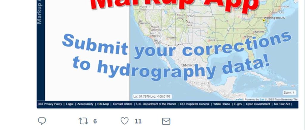
12 + Markup Application for the National Hydrography Datasets Oklahoma GI Council Meeting November 2, 2018 Claire DeVaughan US Geological Survey
 The drainage network with features such as rivers, streams,")
 The drainage basins at 8 scales")

13 + 2 USGS National Hydrography Datasets Hydrologic networks, units, catchments, and more National Hydrography Dataset (NHD) The drainage network with features such as rivers, streams, canals, lakes, ponds, and stream gages. National Hydrography Dataset Watershed Boundary Dataset (WBD) The drainage basins at 8 scales of a nested hierarchy; defines the areal extent of surface water drainage to a point NHDPlus Incorporates many of the best features of the NHD, WBD and elevation data to enable estimates of flow volume and velocity Watershed Boundary Dataset NHDPlus

14 + 3 NHDPlus includes A nationally seamless network of stream reaches Value-added attributes for stream network navigation and analysis Flow surfaces in raster format Elevation-based catchment areas for each stream segment that catchment area Create a seamless, scalable hydrologic framework Enable modeling of water flow across the landscape, linking terrestrial characteristics to the stream network NHD Streams

15 + 4 NHDPlus High Resolution NHD Plus HR The Hydrography Requirements and Benefits Study: ~ 80% of users need the functionality of NHDPlus but at a higher resolution USGS is building NHDPlus HR from the highest available resolution NHD and WBD data, and 10m 3DEP data The results are more accurate and better maintained than the current, medium resolution NHDPlus NHDPlus HR will have multi-scale representation capabilities with the new VisibilityFilter attribute
16 + 5 NHDPlus Data Comparison Medium Resolution versus High Resolution NHDPlus Medium Resolution (V2) NHDPlus High Resolution Number of catchments ~2.7 Million nationally ~26 Million nationally Elevation Input NHD Input National 1 Arc-Second Seamless DEM (30 meters) Medium Resolution NHD 1:100K National 1/3 Arc-Second Seamless DEM from 3DEP (10 meters) High Resolution NHD 1:24K or better WBD Input Composite Updated WBD Catchment size Avg. 1.2 square miles Avg. ~0.2 square miles Flow estimates Mean annual, mean monthly Mean annual

17 + 6 Keeping Up with Change


18 + 7 Isolated network Flowline very close but not connected to network Contours support connecting the features

19 + 8 Incorrect Flow Direction Contours show stream is flowing uphill Change flow direction of the feature


20 Markup Application + Markup Reviewer 9 Desktop ArcGIS Add-in Markup App - Web Application Users: general public, NHD and WBD users, academia, etc. Purpose: - Viewing NHD, NHDPlus HR, WBD and submitted markups - Creating new markups Access: public access Users: Internal NGTOC editors, trained NHD and WBD partners only Purpose: - View markups submitted through web application - Update markup status Access: restricted access for download on Hydrographic Data Community

21 + Markup Application live demo - Suggest edits to NHD, WBD, and NHDPlus HR - Requirements: Gmail account and Google Chrome 10

22 Markup Life Cycle - Validation and Editing + 11 Markup Status Field Change: Who, where, how? In Progress Perform Edits Submitted Review and Validate State partners and NGTOC Resolved General Public State partners and NGTOC Won t Fix Web Application Markup Reviewer NHD and WBD Editing Tools Markup Reviewer
23 + 12 Markup Resources NHD: science systems/ngp/national hydrography Markup Application: app/ Markup App FAQs: mrs.cr.usgs.gov/markupweb/webhelp/markup_q_as.htm Markup User Guide: mrs.cr.usgs.gov/markupweb/webhelp/markupuserguide.htm Training Video: Markup Community (contact Claire DeVaughan at to request access): Questions and Training Requests:

24 + 13 Twitter
25 + 14 Questions? Claire DeVaughan National Map Liaison for TX & OK or
26 NHD Markup Application Resources The Markup Application is a web based mapping communication tool that allows users to suggest edits, or markups, to the National Hydrography Dataset (NHD), Watershed Boundary Dataset (WBD), and National Hydrography Dataset Plus High Resolution (NHDPlus HR). NHD: https: // science systems/ngp/national hydrography Markup Application: app/ Markup Appp FAQs: mrs.cr.usgs.gov/markupweb/webhelp/markup_q_as.htm Markup User Guide: mrs.cr.usgs. gov/markupweb/webhelp/markupuserguide.htm Training Video: / Questions and Training Requests: markup@usgs.gov
USGS Hydrography Overview. May 9, 2018
 + 1 USGS Hydrography Overview May 9, 2018 + 2 The National Geospatial Program Provides the geospatial baseline of the Nation s topography, natural landscape and built environment through The National Map,
What s New in Topographic Information - USGS National Map
 + What s New in Topographic Information - USGS National Map SARGIS Workshop November 14, 2016 Rob Dollison, 703-648-5724 rdollison@usgs.gov + USGS 2 National Geospatial Program The National Geospatial
The 3D Elevation Program: Overview. Jason Stoker USGS National Geospatial Program ESRI 2015 UC
 + The 3D Elevation Program: Overview Jason Stoker USGS National Geospatial Program ESRI 2015 UC + 2 A little history USGS has a long, proud tradition of mapmaking (2009) + 3 The changing times Mapping
USGS National Hydrography Dataset (NHD) and NHDPlus
 and NHDPlus") + 1 + USGS National Hydrography Dataset (NHD) and NHDPlus Al Rea USGS National Geospatial Program Western States Water Council August 1, 2018 + 2 USGS National Hydrography Datasets Hydrologic networks,
+ 1 + USGS National Hydrography Dataset (NHD) and NHDPlus Al Rea USGS National Geospatial Program Western States Water Council August 1, 2018 + 2 USGS National Hydrography Datasets Hydrologic networks,
NEEA Refresh aka 3D Nation Requirements and Benefits Study. Allyson Jason, Carol Ostergren, Xan Fredericks and Lou Driber November 9, 2017
 + NEEA Refresh aka 3D Nation Requirements and Benefits Study Allyson Jason, Carol Ostergren, Xan Fredericks and Lou Driber November 9, 2017 + 2 Study Context Background The National Enhanced Elevation
USGS National Geospatial Program Understanding User Needs. Dick Vraga National Map Liaison for Federal Agencies July 2015
 + USGS National Geospatial Program Understanding User Needs Dick Vraga National Map Liaison for Federal Agencies July 2015 + Topics 2 Background Communities of Use User Surveys National Map Liaisons Partnerships
The National Hydrography Dataset in the Pacific Region. U.S. Department of the Interior U.S. Geological Survey
 The National Hydrography Dataset in the Pacific Region U.S. Department of the Interior U.S. Geological Survey The National Map The National Map is built on partnerships and standards The National Map consists
Tracy Fuller U. S. Geological Survey. February 24, 2016
 U. S. Geological Survey Arctic Elevation Data Involvement Statewide Alaska IfSAR Radar Collection Program Pan-Arctic Digital Elevation Map International Coordination Tracy Fuller U. S. Geological Survey
Pictometry GIS and Integration Solutions. Presented by Peter White, GISP GIS Product Manager, Pictometry International Corp.
 Pictometry GIS and Integration Solutions Presented by Peter White, GISP GIS Product Manager, Pictometry International Corp. 1. Pictometry Web Integration Solutions 2. Advanced LiDAR Sensor and Solutions
U.S. Geological Survey Agency Briefing for MAPPS Mark L. DeMulder Director, National Geospatial Program. March 12, 2013
 + U.S. Geological Survey Agency Briefing for MAPPS Mark L. DeMulder Director, National Geospatial Program March 12, 2013 + 3D Elevation Program (3DEP) National Leadership The National Enhanced Elevation
What's New with NHDPlus (Classic)?
?") What's New with NHDPlus (Classic)? 1987 Reach File Version 1 2017 - NHDPlus Annie Mejaes EPA, Office of Water 2 Overview NHD-NHDPlus Basics Evolving NHD-NHDPlus Data and Tools Training and Support The
What's New with NHDPlus (Classic)? 1987 Reach File Version 1 2017 - NHDPlus Annie Mejaes EPA, Office of Water 2 Overview NHD-NHDPlus Basics Evolving NHD-NHDPlus Data and Tools Training and Support The
National Hydrography Dataset (NHD) Update Project for US Forest Service Region 3
 Update Project for US Forest Service Region 3") National Hydrography Dataset (NHD) Update Project for US Forest Service Region 3 Allison Moncada California State University, Northridge February 2017 July 2017 Advisor: Joel Osuna Center for Geographical
National Hydrography Dataset (NHD) Update Project for US Forest Service Region 3 Allison Moncada California State University, Northridge February 2017 July 2017 Advisor: Joel Osuna Center for Geographical
Creating Watersheds and Stream Networks. Steve Kopp
 Creating Watersheds and Stream Networks Steve Kopp Workshop Overview Demo Data Understanding the tools Elevation Data Types DEM : Digital Elevation Model bare Earth DSM : Digital Surface Model Data Structure
USGS Data Initiatives for Elevation, Streams and Topo Maps
 USGS Data Initiatives for Elevation, Streams and Topo Maps Gary Merrill, USGS Geospatial Liaison for Carolinas Silvia Terziotti, USGS Assoc. Geospatial Liaison for North Carolina, Water Communities of
3D Elevation Program, Lidar in Missouri. West Central Regional Advanced LiDAR Workshop Ray Fox
 3D Elevation Program, Lidar in Missouri West Central Regional Advanced LiDAR Workshop Ray Fox National Enhanced Elevation Assessment (Dewberry, 2011) Sponsored by the National Digital Elevation Program
Lidar-derived Hydrography as a Source for the National Hydrography Dataset
 Lidar-derived Hydrography as a Source for the National Hydrography Dataset Lidar-Derived Hydrography, Bathymetry, and Topobathymetry in the National Hydrography Dataset and 3-Dimensional Elevation Program
Web-Based Engine For Discovery Of Observations Using Landscape Units
 City University of New York (CUNY) CUNY Academic Works International Conference on Hydroinformatics 8-1-2014 Web-Based Engine For Discovery Of Observations Using Landscape Units Haowen Xu Abbas Ali Amir
A Comprehensive Inventory of the Number of Modified Stream Channels in the State of Minnesota. Data, Information and Knowledge Management.
 A Comprehensive Inventory of the Number of Modified Stream Channels in the State of Minnesota Data, Information and Knowledge Management Glenn Skuta Environmental Analysis and Outcomes Division Minnesota
A Simple Drainage Enforcement Procedure for Estimating Catchment Area Using DEM Data
 A Simple Drainage Enforcement Procedure for Estimating Catchment Area Using DEM Data David Nagel, John M. Buffington, and Charles Luce U.S. Forest Service, Rocky Mountain Research Station Boise Aquatic
International Geospatial Harmonization of Sister Datasets Hydrography and Watershed Boundaries between Canada and the U.S.A
 International Geospatial Harmonization of Sister Datasets Hydrography and Watershed Boundaries between Canada and the U.S.A by Judy Kwan and Pete Steeves Environment Canada and US Geological Survey in
Manitoba s Elevation (LiDAR) & Imagery Datasets. Acquisition Plans & Opportunities for Collaboration
 & Imagery Datasets. Acquisition Plans & Opportunities for Collaboration") Manitoba s Elevation (LiDAR) & Imagery Datasets Acquisition Plans & Opportunities for Collaboration Manitoba Planning Conference May 2017 Presentation Outline Manitoba s Elevation (LiDAR) and Imagery Datasets
Manitoba s Elevation (LiDAR) & Imagery Datasets Acquisition Plans & Opportunities for Collaboration Manitoba Planning Conference May 2017 Presentation Outline Manitoba s Elevation (LiDAR) and Imagery Datasets
Designing a Dam for Blockhouse Ranch. Haley Born
 Designing a Dam for Blockhouse Ranch Haley Born CE 394K GIS in Water Resources Term Paper Fall 2011 Table of Contents Introduction... 1 Data Sources... 2 Precipitation Data... 2 Elevation Data... 3 Geographic
Base Level Engineering FEMA Region 6
 Base Level Engineering Over the past five years, has been evaluating its investment approach and data preparation work flow to establish an efficient and effective change in operation, generating an approach
Statewide Topographic Mapping Program
 Statewide Topographic Mapping Program February 28, 2018 www.dotd.la.gov Outline Purpose of the Statewide Topographic Mapping Program History Breakdown of R.S. 48:36 - Topographic Mapping Statewide Topographic
MISSOURI LiDAR Stakeholders Meeting
 MISSOURI LiDAR Stakeholders Meeting East-West Gateway June 18, 2010 Tim Haithcoat Missouri GIO Enhanced Elevation Data What s different about it? Business requirements are changing.fast New data collection
Improvement of the National Hydrography Dataset for US Forest Service Region 3 in Cooperation with the National Forest Service
 Improvement of the National Hydrography Dataset for US Forest Service Region 3 in Cooperation with the National Forest Service Christian L. DeCasas California State University, Northridge November 7 th,
GIS Changing the World GIS Day November 15, 2017
 + GIS Changing the World GIS Day November 15, 2017 + Growing Up On The Farm 3 Geographic Information in DNR A 75 year history of mapping and GIS. Forest type map from 1944. State of Washington - Division
Lecture 3. Data Sources for GIS in Water Resources
 Lecture 3 Data Sources for GIS in Water Resources GIS in Water Resources Spring 2015 http://www.data.gov/ 1 USGS GIS data for Water http://water.usgs.gov/maps.html Watersheds of the US 2-digit water resource
Leveraging LiDAR for Statewide NHD Hydrography Projects. Susan Phelps, CFM, GISP
 Leveraging LiDAR for Statewide NHD Hydrography Projects Susan Phelps, CFM, GISP Mon, July 11 th, 2016 National Hydrography Dataset (NHD) Background Why Local-Res NHD? Drivers Include: Availability of accurate
IWG-OCM Update For NCSS
 IWG-OCM Update For NCSS Data Supporting Science and Sound Decision-Making Ashley Chappell January 9, 2018 NOAA IOCM Coordination Team Members National Environmental Satellite, Data and Information Service:
MAPPS/USGS Liaison Meeting U.S. Department of the Interior U.S. Geological Survey
 MAPPS/USGS Liaison Meeting U.S. Department of the Interior U.S. Geological Survey Kevin Gallagher, Associate Director, Core Science Systems Greg Stensaas, Earth Resources and Observation Science Center
Office of Technology Partnerships GIS Collaboration
 Office of Technology Partnerships GIS Collaboration State GIS Update April 21, 2017 Mark Holmes, GISP Outline MGF Upgrade Project Census Programs Imagery Update LiDAR Update Open Discussion 2 MGF Background
Drainage Area: GL, VPU: 04 - Release Notes. 12/01/2018 Updated and New Data
 Drainage Area: GL, VPU: 04 - Release Notes 12/01/2018 Updated and New Data Time of Travel and Related Attributes: The new and updated data is included in new versions of the NHDPlusAttributes and EROMExtension
NATIONAL HYDROGRAPHY DATASET (NHD) UPDATE PROJECT FOR US FOREST SERVICE REGION 3
 UPDATE PROJECT FOR US FOREST SERVICE REGION 3") NATIONAL HYDROGRAPHY DATASET (NHD) UPDATE PROJECT FOR US FOREST SERVICE REGION 3 Allison Moncada California State University, Northridge February 2018 July 2018 Advisor: Joel Osuna Center for Geospatial
NATIONAL HYDROGRAPHY DATASET (NHD) UPDATE PROJECT FOR US FOREST SERVICE REGION 3 Allison Moncada California State University, Northridge February 2018 July 2018 Advisor: Joel Osuna Center for Geospatial
ELEVATION. The Base Map
 ELEVATION The Base Map Basic Elevation Types: Points X, Y, Z Irregular distribution Cumbersome Typical sources Lidar Stereo photography Ground survey ASCII, LAS formats Basic Elevation Types: Contour Lines
Hydrologic Engineering Applications of Geographic Information Systems
 Hydrologic Engineering Applications of Geographic Information Systems Davis, California Objectives: The participant will acquire practical knowledge and skills in the application of GIS technologies for
Using ArcGIS for Hydrology and Watershed Analysis:
 Using ArcGIS 10.2.2 for Hydrology and Watershed Analysis: A guide for running hydrologic analysis using elevation and a suite of ArcGIS tools Anna Nakae Feb. 10, 2015 Introduction Hydrology and watershed
Introduction. Elevation Data Strategy. Status and Next Steps
 1 2 Introduction Elevation Data Strategy Status and Next Steps 3 Canada is the 2nd largest country in the world - 9.9 million sq km Surrounded by 3 oceans with 202 000 km of coastline Population over 35
MAPPING ALASKA S WATERS
 MAPPING ALASKA S WATERS NHD Advisory Team Call December, 16 2014 K a c y K r i e ge r kacy.krieger@uaa.alaska.edu Alaska Hydrography Coordinator ALASKA S WATER > 3,000,000 Mapped Lakes and Ponds > 847,000
Improvement of the National Hydrography Dataset for Parts of the Lower Colorado Region and Additional Areas of Importance to the DLCC
 Improvement of the National Hydrography Dataset for Parts of the Lower Colorado Region and Additional Areas of Importance to the DLCC Carlos Reyes-Andrade California State University, Northridge September
GIS in Water Resources Exercise #4 Solution Prepared by Irene Garousi-Nejad and David Tarboton
 GIS in Water Resources Exercise 4 Solution Prepared by Irene Garousi-Nejad and David Tarboton 1. Cell length (N-S) in m, width (E-W) in m, area in m 2 for the DEM cells in the merged DEM. N-S y = R e φ
Within this document, the term NHDPlus is used when referring to NHDPlus Version 2.1 (unless otherwise noted).
.") Exercise 7 Watershed Delineation Using ArcGIS Spatial Analyst Last Updated 4/6/2017 Within this document, the term NHDPlus is used when referring to NHDPlus Version 2.1 (unless otherwise noted). There
Exercise 7 Watershed Delineation Using ArcGIS Spatial Analyst Last Updated 4/6/2017 Within this document, the term NHDPlus is used when referring to NHDPlus Version 2.1 (unless otherwise noted). There
Stream Correction for Local Government GIS
 Stream Correction for Local Government GIS A Practical Guide and Introduction Nicholas McKenny Penn State Adviser: James O'Brien 1/16 Presentation Outline Existing Situation Solution, Goals, & Hopes Guide
Welcome to NR502 GIS Applications in Natural Resources. You can take this course for 1 or 2 credits. There is also an option for 3 credits.
 Welcome to NR502 GIS Applications in Natural Resources. You can take this course for 1 or 2 credits. There is also an option for 3 credits. The 1st credit consists of a series of readings, demonstration,
State GIS Update. Master Address Repository (MAR) IMAGIN 2016 Everett Root May 16, 2016
 IMAGIN 2016 Everett Root May 16, 2016") State GIS Update Master Address Repository (MAR) IMAGIN 2016 Everett Root roote@michigan.gov May 16, 2016 Master Address Repository Mark Holmes GeoSpatial Services Manager (MAR) Josh Ross Framework Manager
State GIS Update Master Address Repository (MAR) IMAGIN 2016 Everett Root roote@michigan.gov May 16, 2016 Master Address Repository Mark Holmes GeoSpatial Services Manager (MAR) Josh Ross Framework Manager
Gulf Coast Joint Venture GEOSPATIAL ACTIVITIES AND DATA NEEDS
 Gulf Coast Joint Venture GEOSPATIAL ACTIVITIES AND DATA NEEDS GCJV Background Purpose: The Gulf Coast Joint Venture is the regionally based, biologically driven, landscape oriented volunteer partnership
GeoSUR SRTM 30-m / TPS
 GeoSUR SRTM 30-m / TPS Wm Matthew Cushing (USGS) 16 May 2013 U.S. Department of the Interior U.S. Geological Survey SRTM Mission Shuttle Radar Topography Mission (SRTM) Space Shuttle Endeavour during the
Geospatial Data, Services, and Products. National Surveying, mapping and geospatial conference
 Geospatial Data, Services, and Products Federal Programs -- USDA NRCS National Surveying, mapping and geospatial conference March 15, 2016 NRCS Applications using Geosaptial Products & Services Field
ARMSTRONG COUNTY, PA
 ARMSTRONG COUNTY, PA Revised Preliminary DFIRM Mapping March 31, 2013 Kevin Donnelly, P.E., CFM GG3, Greenhorne & O Mara, Inc. Presentation Agenda Armstrong County DFIRM Overview - June 25, 2010 DFIRM
Introducing Iowa StreamStats Version 4, a Redesign of the USGS Application for Estimating Streamflow Stats
 Introducing Iowa StreamStats Version 4, a Redesign of the USGS Application for Estimating Streamflow Stats Presented at the 2016 Iowa Water Conference Ames, IA March 24, 2016 by David Eash U.S. Geological
Storm Surge Analysis Update Meeting Cross City, Florida June 17, 2014
 Big Bend Coastal Storm Surge Study Storm Surge Analysis Update Meeting Cross City, Florida June 17, 2014 Introductions Risk MAP Project Team FEMA Region IV Florida Division of Emergency Management (FDEM)
Hydrologically Consistent Pruning of the High- Resolution National Hydrography Dataset to 1:24,000-scale
 Hydrologically Consistent Pruning of the High- Resolution National Hydrography Dataset to 1:24,000-scale Lawrence V. Stanislawski 1, Ariel Doumbouya 2, Barbara P. Buttenfield 3, 1 Center for Excellence
GRAPEVINE LAKE MODELING & WATERSHED CHARACTERISTICS
 GRAPEVINE LAKE MODELING & WATERSHED CHARACTERISTICS Photo Credit: Lake Grapevine Boat Ramps Nash Mock GIS in Water Resources Fall 2016 Table of Contents Figures and Tables... 2 Introduction... 3 Objectives...
CENTRAL TEXAS HILL COUNTRY FLOOD
 CENTRAL TEXAS HILL COUNTRY FLOOD Term project report DECEMBER 7, 2018 UNIVERSITY OF TEXAS AT AUSTIN CE394K: GIS in Water Resources Engineering RIFAAI Mohamed Talha Table of Contents Introduction... 3 Context...
Hydrography Webinar Series
 Hydrography Webinar Series Session 2 May 21, 2015 U.S. Department of the Interior U.S. Geological Survey U.S. GEOLOGICAL SURVEY HYDROGRAPHY WEBINAR SERIES Hosted by: Jeff Simley Al Rea Hydrography Webinar
Positioning the Pacific: NOAA s Geospatial Activities. Juliana Blackwell, Director NOAA s National Geodetic Survey March 6, 2012
 Positioning the Pacific: NOAA s Geospatial Activities Juliana Blackwell, Director NOAA s National Geodetic Survey March 6, 2012 A Common Problem of the Early 19 th Century 1807 President Thomas Jefferson
Emergency Planning. for the. Democratic National. Convention. imaging notes // Spring 2009 //
 Emergency Planning for the Democratic National Convention The DRAPP Demonstrates Partnership among Local, Regional, State, Utility and Federal Governments 14 imaging notes // Spring 2009 // www.imagingnotes.com
Geospatial Data Sources. SLO GIS User Group June 8, 2010
 Geospatial Data Sources SLO GIS User Group June 8, 2010 Presenters Drew Decker USGS Southern California Geospatial Liaison Kelly Bobbitt Mike Bobbitt & Associates Joe Larson Cal Fire Peter Meertens Regional
Preparing a NFIE-Geo Database for Travis County
 Preparing a NFIE-Geo Database for Travis County By David R. Maidment Center for Research in Water Resources University of Texas at Austin 2 February 2015 Contents Introduction... 1 Step 1. Download and
Hydrologic and Hydraulic Analyses Using ArcGIS
 Hydrologic and Hydraulic Analyses Using ArcGIS Two day training class Overview ArcGIS and Arc Hydro provide strong foundation for support of hydrologic and hydraulic (H&H) analyses. This two-day course
A GIS-based Approach to Watershed Analysis in Texas Author: Allison Guettner
 Texas A&M University Zachry Department of Civil Engineering CVEN 658 Civil Engineering Applications of GIS Instructor: Dr. Francisco Olivera A GIS-based Approach to Watershed Analysis in Texas Author:
BSYSE 456/556 Surface Hydrologic Processes and Modeling
 BSYSE 456/556 Surface Hydrologic Processes and Modeling Lab 9 (Prepared by Erin Brooks and Jan Boll, UI, and Joan Wu, WSU) P Introduction One of the most difficult tasks in watershed assessment and management
Exercise 4. Watershed and Stream Network Delineation
 Exercise 4. Watershed and Stream Network Delineation GIS in Water Resources, Fall 2018 Prepared by David G Tarboton and David R. Maidment Revised 9 October, 2018 Purpose The purpose of this exercise is
Esri Image & Mapping Forum 9 July 2017 Geiger-Mode for Conservation Planning & Design by USDA NRCS NGCE
 Esri Image & Mapping Forum 9 July 2017 Geiger-Mode for Conservation Planning & Design by USDA NRCS NGCE For over 75 years, the Natural Resources Conservation Service has been a pioneer in conservation,
Varying Bathymetric Data Collection Methods and their Impact on Impoundment Volume and Sediment Load Calculations I.A. Kiraly 1, T.
 Varying Bathymetric Data Collection Methods and their Impact on Impoundment Volume and Sediment Load Calculations I.A. Kiraly 1, T. Sullivan 2 1 Gomez and Sullivan Engineers, D.P.C., 41 Liberty Hill Road,
DRAFT FOR REVIEW PURPOSES ONLY MEMORANDUM OF UNDERSTANDING BETWEEN THE DEPARTMENT OF THE INTERIOR U.S. GEOLOGICAL SURVEY AND
 MEMORANDUM OF UNDERSTANDING BETWEEN THE DEPARTMENT OF THE INTERIOR U.S. GEOLOGICAL SURVEY AND THE WEST VIRGINIA OFFICE OF GIS STATE COORDINATOR FOR THE STEWARDSHIP OF THE NATIONAL HYDROGRAPHY DATASET I.
Visualising time-series data with the Australian Hydrological Geospatial Fabric & the Geofabric Sample Toolbox
 Visualising time-series data with the Australian Hydrological Geospatial Fabric & the Geofabric Sample Toolbox Darren G Smith #Locate15, Thursday 12 th of March 2015 Presentation outline Quick background
Summary of Available Datasets that are Relevant to Flood Risk Characterization
 Inter-Agency Characterization Workshop February 25-27, 2014 USACE Institute for Water Resources, Alexandria, VA, IWR Classroom Summary of Available Datasets that are Relevant to Characterization National
Evaluating Physical, Chemical, and Biological Impacts from the Savannah Harbor Expansion Project Cooperative Agreement Number W912HZ
 Evaluating Physical, Chemical, and Biological Impacts from the Savannah Harbor Expansion Project Cooperative Agreement Number W912HZ-13-2-0013 FY 2016 - First Quarterly Report January 1, 2016 Submitted
The Illinois Height Modernization Program: Improving Elevation Data for Illinois
 The Illinois Height Modernization Program: Improving Elevation Data for Illinois Bev Herzog and Sheen Beaverson Illinois State Geological Survey Institute for Natural Resource Sustainability University
USGS QUADRANGLES IN GOOGLE EARTH
 USGS QUADRANGLES IN GOOGLE EARTH By Thomas G. Davis 1, PhD, PE, PLS and Rollins Turner 2, PhD INTRODUCTION QUADS (http://www.metzgerwillard.us/quads/) is a web-based service for visualizing USGS quadrangle
Link to USGS Phase 6 Land Use Viewer website:
 Chesapeake Bay Program Phase 6 Land Use Review Frequently Asked Questions (FAQ) Link to USGS Phase 6 Land Use Viewer website: http://chesapeake.usgs.gov/phase6/ Sections: 1. Data Review and Production
NWT Open Report Delineation of Watersheds in the Mackenzie Mountains
 NWT Open Report 2015-007 Delineation of Watersheds in the Mackenzie Mountains K.L. Pierce and H. Falck Recommended Citation: Pierce, K.L. and Falck, H., 2015. Delineation of watersheds in the Mackenzie
LiDAR User Data Needs Survey Results
 LiDAR User Data Needs Survey Results June 2012 Introduction The Minnesota Geospatial Information Office (MnGeo) is working with the Minnesota Department of Natural Resources (DNR) to develop a data distribution
Leveraging ArcGIS Online Elevation and Hydrology Services. Steve Kopp, Jian Lange
 Leveraging ArcGIS Online Elevation and Hydrology Services Steve Kopp, Jian Lange Topics An overview of ArcGIS Online Elevation Analysis Using Elevation Analysis Services in ArcGIS for Desktop Using Elevation
Alaska Hydrography Strategic Plan
 Alaska Hydrography Strategic Plan Mapping Alaska s Water 2017-2021 Prepared by the Alaska Hydrography Technical Working Group and Alaska Hydrography Database Alaska Hydrography Strategic Plan A laska is
Hydrography Program Highlights and Demonstrations
 Hydrography Program Highlights and Demonstrations 2018-05-09, Reston North American Mapping Mark Sondheim & Marie-Eve Martin Overview Common Hydrology Features model: CHyF (chief) Linked Open Data: LOD
Esri s Living Atlas of the World Community Maps
 Esri s Living Atlas of the World Community Maps Seth Sarakaitis Wednesday May 7, 2014 ArcGIS Living Atlas Concept Living Atlas Content Tour Contributing to the Living Atlas (Community Maps) Seth Sarakaitis
GIS Data Acquisition. Lauren Walker
 GIS Data Acquisition Lauren Walker Table of Contents Soil Data Mart - SSURGO... 3 Background... 3 Data Collection... 3 Confirming Projection... 8 Helpful Hints for Soil Data Mart... 9 More Information...
ArcGIS Data Reviewer: Assessing Positional Accuracy. Roslyn Dunn
 ArcGIS Data Reviewer: Assessing Positional Accuracy Roslyn Dunn What is ArcGIS Data Reviewer? Data Quality Management for ArcGIS Provides - Rule-based validation - Interactive tools - Track errors Validate
Flood Inundation Mapping
 KU GIS Day 2009 November 18, 2009 Flood Inundation Mapping Wendy L. Pearson NOAA s National Weather Service Central Region Headquarters Kansas City, Missouri Flood Inundation Mapping Objectives: Overview
A Help Guide for Using gssurgo to Find Potential Wetland Soil Landscapes
 A Help Guide for Using gssurgo to Find Potential Wetland Soil Landscapes Wetland Mapping Consortium Webinar September 17, 2014 Dr. John M. Galbraith Crop & Soil Environmental Sciences Virginia Tech Wetland
USING GIS TO MODEL AND ANALYZE HISTORICAL FLOODING OF THE GUADALUPE RIVER NEAR NEW BRAUNFELS, TEXAS
 USING GIS TO MODEL AND ANALYZE HISTORICAL FLOODING OF THE GUADALUPE RIVER NEAR NEW BRAUNFELS, TEXAS ASHLEY EVANS While the state of Texas is well-known for flooding, the Guadalupe River Basin is one of
Flood Hazard Mapping for Canada based on Spatial Data Integration and Modeling
 Flood Hazard Mapping for Canada based on Spatial Data Integration and Modeling Qiaoping Zhang 1, Michael Wollersheim 1, Natalie Findlay 1, Stephen Griffiths 1 1 Intermap Technologies Corp., Calgary, AB,
SCAUG Community Maps Building a Living Atlas of the World
 SCAUG Community Maps Building a Living Atlas of the World Mark Stewart Topics: SCAUG ArcGIS Online Overview Community Maps Overview Community Maps Workflow Update Process Utilizing Your Contribution Community
Chesapeake Bay Program s New Land Cover Map (and some other neat stuff)
") Chesapeake Bay Program s New Land Cover Map (and some other neat stuff) Cassandra Pallai Geospatial Project Manager Chesapeake Conservancy December 6, 2016 Potomac Watershed Partnership Chesapeake Conservancy
Chesapeake Bay Program s New Land Cover Map (and some other neat stuff) Cassandra Pallai Geospatial Project Manager Chesapeake Conservancy December 6, 2016 Potomac Watershed Partnership Chesapeake Conservancy
Using the Stock Hydrology Tools in ArcGIS
 Using the Stock Hydrology Tools in ArcGIS This lab exercise contains a homework assignment, detailed at the bottom, which is due Wednesday, October 6th. Several hydrology tools are part of the basic ArcGIS
3/29/11. Why bother with tools? Incorporating Decision Support Tools into Climate Adaptation Planning. A Simplified Planning Process
 Incorporating Decision Support Tools into Climate Adaptation Planning Why bother with tools? Tools don t eliminate complexity but they can help deal with it" Tools can:"! Help incorporate science into
ArcGIS Online Tools and Water-Related Web Services You Can Use Every Day of Your Life!
 ArcGIS Online Tools and Water-Related Web Services You Can Use Every Day of Your Life! Brian Rowley, PE, CFM FMA 2014 Annual Conference 1 Gold Rush (49ers) John Sutter Sutter s Mill South fork of American
Wetlands and Riparian Mapping Framework Technical Meeting
 Wetlands and Riparian Mapping Framework Technical Meeting Meghan Burns Landscape Ecologist Linda Vance Senior Ecologist Why wetland and riparian mapping? Preliminary site assessment for the presence of
LIDAR: Statutory Compliance Benefits for Nebraska Natural Resources
 LIDAR: Statutory Compliance Benefits for Nebraska Natural Resources 2011 Nebraska GIS Symposium La Vista, NE April 21, 2011 Doug Hallum, P.G. Integrated Water Management Coordinator Nebraska Department
Floodplain Mapping & Flood Warning Applications in North Carolina
 Floodplain Mapping & Flood Warning Applications in North Carolina Marc Stanard, IT Project Manager Ken Ashe, Assistant Director David Herlong, Flood Warning Program Manager NC Crime Control & Public Safety
Exelis and Esri Technologies for Defense and National Security. Cherie Muleh
 Exelis and Esri Technologies for Defense and National Security Cherie Muleh Cherie.Muleh@exelisinc.com ENVI IMAGERY AND DATA BECOME KNOWLEDGE > Add information from imagery to your GIS > Automated workflows
Base Maps: Creating, Using & Participating
 Base Maps: Creating, Using & Participating Michael Fashoway & Erin Geraghty Montana Base Map Service Center 2010 MAGIP Technical Session October 28, 2010 What is a Base Map? Using a Base Map Creating a
The Coastal Change Analysis Program and the Land Cover Atlas. Rebecca Love NOAA Office for Coastal Management
 The Coastal Change Analysis Program and the Land Cover Atlas Rebecca Love NOAA Office for Coastal Management Natural Infrastructure = Greater Resilience NOAA C-CAP Regional Land Cover and Change coast.noaa.gov/digitalcoast/data/ccapregional
To: Ross Martin, Lisa Stapleton From: Brad Lind Subject: Joint Funding Agreement with USGS for 2012 Imagery Date: March 14, 2012.
 To: Ross Martin, Lisa Stapleton From: Brad Lind Subject: Joint Funding Agreement with USGS for 2012 Imagery Date: March 14, 2012 Attached are two copies of the Joint Funding Agreement (JFA) between SanGIS
GEOMATICS. Shaping our world. A company of
 GEOMATICS Shaping our world A company of OUR EXPERTISE Geomatics Geomatics plays a mayor role in hydropower, land and water resources, urban development, transport & mobility, renewable energy, and infrastructure
Maryland State Geographic Information Committee
 MD IMAP 3.0 Next generation of MD imap platform running on Esri s ArcGIS Enterprise Promoting authoritative data sharing among State agencies via Portal for ArcGIS Centralization of GIS infrastructure
What is the Living Atlas for ArcGIS and How Can you be Involved?
 Federal GIS Conference February 9 10, 2015 Washington, DC What is the Living Atlas for ArcGIS and How Can you be Involved? Clint Brown Deane Kensok Agenda Introduction to Living Atlas - Transformation
Use of Elevation Data in NOAA Coastal Mapping Shoreline Products. Coastal GeoTools April 1, 2015
 Use of Elevation Data in NOAA Coastal Mapping Shoreline Products Coastal GeoTools April 1, 2015 - NOAA s Coastal Mapping Program & CUSP - Shoreline Uses, Delineation Issues, Definitions - Current Extraction