Ecological Response Units Ecosystem Mapping System for the Southwest US
|
|
|
- Mariah Lyons
- 5 years ago
- Views:
Transcription
1 Ecological Response Units Ecosystem Mapping System for the Southwest US J. C. Moreland, W. A. Robbie, F. J. Triepke, E. H. Muldavin, and J. R. Malusa
2 Objectives What are Ecological Response Units? What is the difference in existing vegetation vs ecosystem mapping? Discussion of the process of creating an ecosystem mapping product for resource management Lessons learned
3 Why are we doing this? Natural Resource Management Ecological Assessment of vegetation composition, structure, and process as influenced by past and present conditions, and future trends. Creating a picture of Then vs Now to help shape recommendations towards informing a need for change within land management decisions. Facilitates vegetation patch analysis Wildfire Probability Analysis Foundation for implementation monitoring Forest, Landscape, Habitat restoration projects Regional All-Lands Wildfire Risk Assessment Useful in modeling and landscape level analyses

4 What are Ecological Response Units (ERUs)? Ecological Response Units facilitate landscape analysis and planning. The framework represents all major ecosystem types of the southwest region, and represents a stratification of biophysical themes.

5 What are Ecological Response Units (ERUs)? Ecological Response Units (ERUs) are map unit constructs, technical groupings of finer vegetation classes. The suite of vegetation classes that make up any given ERU share similar disturbance dynamics, plant species dominants, and theoretical succession sequence (potential vegetation).
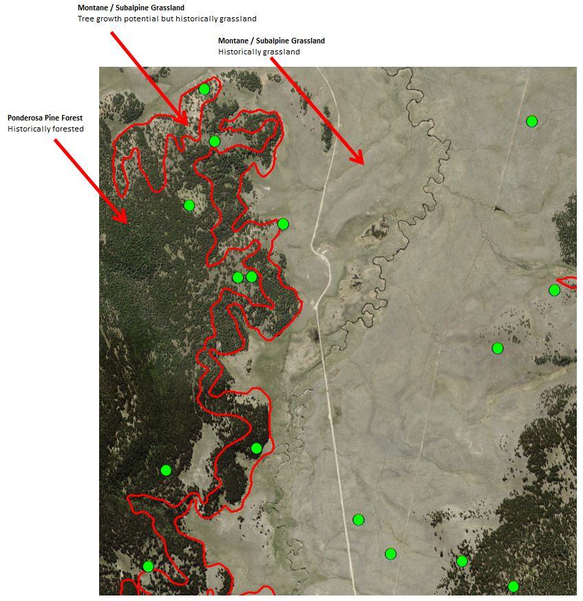
6 Ecosystem Mapping vs Existing Vegetation ERUs are used to define Historic/Reference Conditions within a mapping unit by integrating: Site potential (soil physical and chemical properties, geology, geomorphology, aspect, slope, climate variables, geographic location) Fire regime (historic and contemporary) Neighboring vegetation communities Seral state sequence Existing Vegetation = What s out there now


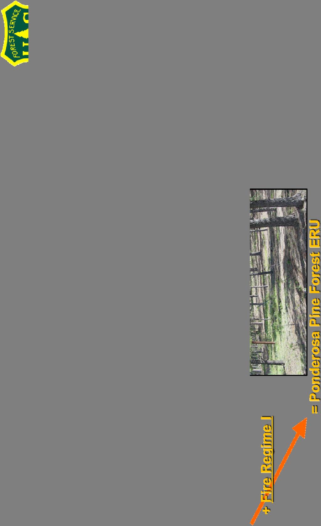
7 ERU: potential natural vegetation with disturbance
8
9
10 A collaborative project Resource Specialists from various program areas Fuels Vegetation Ecology Soil Science Geographers Specialists from various administrative levels of the Forest Service Ranger Districts Forest Supervisor s Office Regional Office Specialists from outside of the agency Universities
11 Initial Project Scope Start with previous version ERUv4 Add in new Terrestrial Ecological Unit Inventory (TEUI) survey data Add in corrected data from collaborative assessment made by University of AZ Ecologist Jim Malusa Identify anomalous attribution of ERU types using Climate Gradient and correct for most appropriate ERU type Product = ERUv5


12 Climate Gradients of the Southwest Red-High Sun Mild Orange-Low Sun Mild Blue-Low Sun Cool Green-High Sun Cool Light Yellow-Semi-Arid Pink-Sub-Humid
13 Actual Data inputs Terrestrial Ecological Unit Inventory (TEUI)-Field survey data-national Forest System (NFS) lands ERUv4 Climate Gradient Corrections-All lands Univ. of AZ Ecologist Jim Malusa ERUv4 Review-Selected lands in SE AZ ERU corrections using SW Biotic Communities and climate gradient percentagesall lands Integrated Landscape Assessment Project (ILAP)-Remote sensing product-all lands Regional Riparian Mapping Project (RMAP)-Riparian corridors in AZ and NM-all lands ERU subclass updates from ILAP grid analysis-all lands Neighbor analysis corrections
14 The need for standards
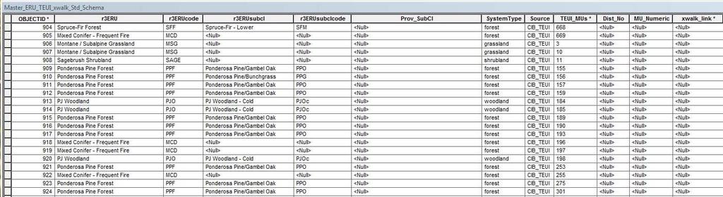
15 Data crosswalks
16 The build: A hierarchy of data layers RMAP TEUI Univ of AZ / Climate Gradient / SWBC Eval ILAP ERU Version 4
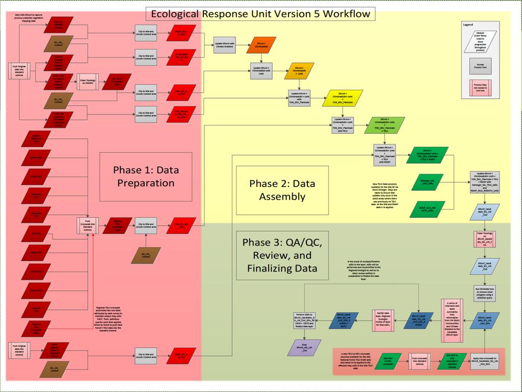
17 Workflow

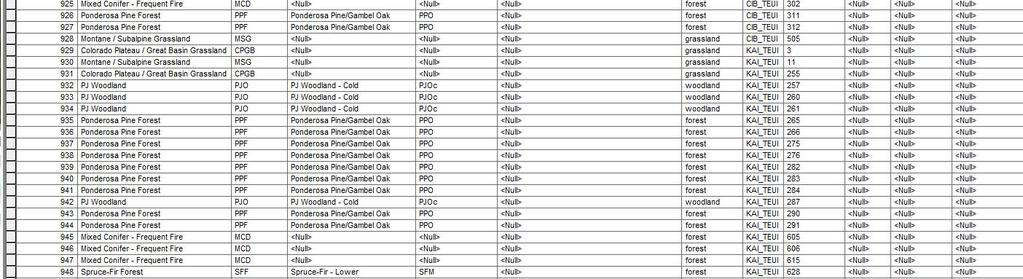
18 The product Northern and southern products developed separately and independently Each evaluated independently Joined together via load 876,000 features (Single part) Additional QA/QC performed afterward Released as Beta version Corporate version in process and release to public and partnerships coming soon Maintenance schedule to incorporate additions and edits to enhance product accuracy and to maintain relevance
19 Lessons learned Time consuming CPU/processor intensive processes 64 bit background geoprocessing Create standards early in the process Establish a master crosswalk that everyone works with Build QA/QC reviews into the process frequently Local level reviews by specialist at the forest Field going personnel with on the ground knowledge weigh in TEUI Surveyors contribution Regional level reviews by specialists at the Regional Office Special review product with analysis metrics Multiple summaries to catch inconsistencies in attribution Make no assumptions about how topologically clean your input data is If the project is on a set timeline (Forest Plan Revision), establish hard deadlines for review and edits GIS and Specialists MUST communicate and learn from one another to understand

20 Questions
Partnering with LANDFIRE, NatureServe, and Heritage Programs. Utilizing Legacy Data for Ecological Site Concept Development and Descriptions
 Partnering with LANDFIRE, NatureServe, and Heritage Programs Utilizing Legacy Data for Ecological Site Concept Development and Descriptions Content LANDFIRE: BpS vs. EVT LANDFIRE: Disturbance Models NatureServe:
Ecological Site Descriptions ESDs : NRCS Site-based Approach to Land Classification and Evaluation. Nels Barrett, NRCS Ecologist SSSSNE 20
 Ecological Site Descriptions ESDs : NRCS Site-based Approach to Land Classification and Evaluation Nels Barrett, NRCS Ecologist SSSSNE 20 Overview Definition of Ecological Sites, ES Content of Ecological
Ecological Site Description Overview
 Ecological Site Description Overview 2018 Coastal Zone Soil Survey (CZSS) Work Planning Conference Savannah, GA January 9th, 2018 Greg Taylor Senior Regional Soil Scientist USDA-NRCS Raleigh, NC j.greg.taylor@nc.usda.gov
ENVS S102 Earth and Environment (Cross-listed as GEOG 102) ENVS S110 Introduction to ArcGIS (Cross-listed as GEOG 110)
 ENVS S110 Introduction to ArcGIS (Cross-listed as GEOG 110)") ENVS S102 Earth and Environment (Cross-listed as GEOG 102) 1. Describe the fundamental workings of the atmospheric, hydrospheric, lithospheric, and oceanic systems of Earth 2. Explain the interactions
ENVS S102 Earth and Environment (Cross-listed as GEOG 102) 1. Describe the fundamental workings of the atmospheric, hydrospheric, lithospheric, and oceanic systems of Earth 2. Explain the interactions
GIS Solutions in Natural Resource Management: Balancing the Technical- Political Equation
 GIS Solutions in Natural Resource Management: Balancing the Technical- Political Equation Stan Morain, Editor SUB Gdttlngen 7 208 520 309 98 A14447 0NW0RD PRESS V? % \
VCS MODULE VMD0018 METHODS TO DETERMINE STRATIFICATION
 VMD0018: Version 1.0 VCS MODULE VMD0018 METHODS TO DETERMINE STRATIFICATION Version 1.0 16 November 2012 Document Prepared by: The Earth Partners LLC. Table of Contents 1 SOURCES... 2 2 SUMMARY DESCRIPTION
Geospatial Data, Services, and Products. National Surveying, mapping and geospatial conference
 Geospatial Data, Services, and Products Federal Programs -- USDA NRCS National Surveying, mapping and geospatial conference March 15, 2016 NRCS Applications using Geosaptial Products & Services Field
Building a National Data Repository
 Building a National Data Repository Mladen Stojic, Vice President - Geospatial 1/30/2013 2012 Intergraph Corporation 1 Information has meaning and gives power only when shared and distributed. Information,
United States Department of the Interior NATIONAL PARK SERVICE Northeast Region
 United States Department of the Interior NATIONAL PARK SERVICE Northeast Region June 17, 2017 REQUEST FOR STATEMENTS OF INTEREST and QUALIFICATIONS Project Title: ASSESSMENT OF NATURAL RESOURCE CONDITION
Wetlands and Riparian Mapping Framework Technical Meeting
 Wetlands and Riparian Mapping Framework Technical Meeting Meghan Burns Landscape Ecologist Linda Vance Senior Ecologist Why wetland and riparian mapping? Preliminary site assessment for the presence of
FOREST FIRE HAZARD MODEL DEFINITION FOR LOCAL LAND USE (TUSCANY REGION)
") FOREST FIRE HAZARD MODEL DEFINITION FOR LOCAL LAND USE (TUSCANY REGION) C. Conese 3, L. Bonora 1, M. Romani 1, E. Checcacci 1 and E. Tesi 2 1 National Research Council - Institute of Biometeorology (CNR-
FOREST FIRE HAZARD MODEL DEFINITION FOR LOCAL LAND USE (TUSCANY REGION) C. Conese 3, L. Bonora 1, M. Romani 1, E. Checcacci 1 and E. Tesi 2 1 National Research Council - Institute of Biometeorology (CNR-
Project Primary Contact: Gregg Servheen, Idaho Department of Fish and Game, PO Box 25 Boise, ID ,
 Project Title: Idaho Montana Divide Project Objective: Pilot the conceptualization and coordination of a transboundary Decision Support System(DSS) for fish, wildlife, and habitats along the Idaho Montana
SPATIAL AND TEMPORAL MODELLING OF ECOSYSTEM SERVICES
 SPATIAL AND TEMPORAL MODELLING OF ECOSYSTEM SERVICES Solen Le Clec h, T.Decaëns, S. Dufour, M. Grimaldi, N. Jégou and J. Oszwald ACES Conference 2016 Jacksonville, Florida (USA). December, 5-9th : issues
Work Group A «Core Data» Report and Update François Chirié, Dominique Laurent, France
 JOINT UN-GGIM: EUROPE ESS MEETING ON THE INTEGRATION OF STATISTICAL AND GEOSPATIAL INFORMATION LUXEMBOURG 11 MARCH 2016 Work Group A «Core Data» Report and Update François Chirié, Dominique Laurent, France
Utah UIC Geospatial Integration EIEN Project
 Utah UIC Geospatial Integration EIEN Project ESRI UC, June 2007 Bert Granberg Utah Automated Geographic Reference Center Utah Automated Geographic Reference Center (AGRC) AGRC Responsibilities Facilitate
STM Development: A Systematic Approach Focused on Quality Control
 STM Development: A Systematic Approach Focused on Quality Control A Lofty Aspiration Tamzen K. Stringham University of Nevada, Reno Multiple Approaches Dig lots of holes - I will figure this out! Hang
Ecosystem classification in the Central Rocky Mountains, Utah
 Ecosystem classification in the Central Rocky Mountains, Utah Introduction Societal demand for sustainable natural resources: Manage ecosystems rather than individual resources; ecosystem-specific approach
City of Manitou Springs
 March 2018 City of Manitou Springs Implementing Land Use tools to reduce and mitigate natural hazard risk Context & History Past Present Historic homes Older infrastructure Hillside development Creekside
Practical Uses of LiDAR in NL A Consultants Perspective
 Practical Uses of LiDAR in NL A Consultants Perspective Adam Anderson, R.P.F. President & CEO Presented by: Peter Davison, R.P.F. Photo Interpretation Specialist Introduction Resource Innovations Inc.
RESEARCH METHODOLOGY
 III. RESEARCH METHODOLOGY 3.1. Time and Research Area The field work was taken place in primary forest around Toro village in Lore Lindu National Park, Indonesia. The study area located in 120 o 2 53 120
Climate Change and Biomes
 Climate Change and Biomes Key Concepts: Greenhouse Gas WHAT YOU WILL LEARN Biome Climate zone Greenhouse gases 1. You will learn the difference between weather and climate. 2. You will analyze how climate
Natural Resource Management. Northern Tasmania. Strategy. Appendix 2
 Natural Resource Management Strategy Northern Tasmania 2015 2020 Appendix 2 Appendix 2 Appendix 2. Carbon Planting Spatial Prioritisation In support of this Strategy s development and implementation, work
Stephanie J. Connolly Forest Soil Scientist
 Stephanie J. Connolly Forest Soil Scientist Approximately 1 million acres High elevation Steep slopes Rain shadow effect Hydrologically shallow soils Sedimentary geology Acidic environments Biodiversity
Climatic and Ecological Conditions in the Klamath Basin of Southern Oregon and Northern California: Projections for the Future
 Climatic and Ecological Conditions in the Klamath Basin of Southern Oregon and Northern California: Projections for the Future A Collaborative Effort by: CLIMATE LEADERSHIP INITIATIVE INSTITUTE FOR A SUSTAINABLE
Landscape Planning and Habitat Metrics
 Landscape Planning and Habitat Metrics Frank W. Davis National Center for Ecological Analysis and Synthesis UC Santa Barbara (Tools for Landscape Biodiversity Planning) Jimmy Kagan Institute for Natural
Chapter 52: An Introduction to Ecology and the Biosphere
 AP Biology Guided Reading Name Chapter 52: An Introduction to Ecology and the Biosphere Overview 1. What is ecology? 2. Study Figure 52.2. It shows the different levels of the biological hierarchy studied
Virginia Shoreline Mapping Tools
 Virginia Shoreline Mapping Tools December 15, 2017 Karen Duhring Center for Coastal Resources Management Virginia Institute of Marine Science College of William & Mary Virginia Shoreline Mapping Tools
Development of Riparian Maps for Sonoma County Long Term Riparian Corridor Conservation. Mark Tukman & Dylan Loudon Tukman Geospatial
 L A N D F O R Development of Riparian Maps for Sonoma County Long Term Riparian Corridor Conservation Mark Tukman & Dylan Loudon Tukman Geospatial L I F E Mark Background on functional riparian mapping
An Introduction to Day Two. Linking Conservation and Transportation Planning Lakewood, Colorado August 15-16, 16, 2006
 An Introduction to Day Two Linking Conservation and Transportation Planning Lakewood, Colorado August 15-16, 16, 2006 1 Agenda Day One Transportation Planning Heritage Program State Wildlife Action Plan
A Regional Database Tracking Fire Footprint Each Year within the South Atlantic Region: Current Database Description and Future Directions
 A Regional Database Tracking Fire Footprint Each Year within the South Atlantic Region: Current Database Description and Future Directions Last Updated on September 30, 2018 Contributors: NatureServe,
Case Study: Ecological Integrity of Grasslands in the Apache Highlands Ecoregion
 Standard 9: Screen all target/biodiversity element occurrences for viability or ecological integrity. Case Study: Ecological Integrity of Grasslands in the Apache Highlands Ecoregion Summarized from: Marshall,
BC s Terrestrial Ecosystem Information
 BC s Terrestrial Ecosystem Information Deepa Spaeth Filatow, PGeo Provincial Bioterrain Specialist BC Ministry of Environment Introduction to Terrestrial Ecosystem Information 2012 03 02 TEI Data Access
NATIONAL HYDROGRAPHY DATASET (NHD) UPDATE PROJECT FOR US FOREST SERVICE REGION 3
 UPDATE PROJECT FOR US FOREST SERVICE REGION 3") NATIONAL HYDROGRAPHY DATASET (NHD) UPDATE PROJECT FOR US FOREST SERVICE REGION 3 Allison Moncada California State University, Northridge February 2018 July 2018 Advisor: Joel Osuna Center for Geospatial
NATIONAL HYDROGRAPHY DATASET (NHD) UPDATE PROJECT FOR US FOREST SERVICE REGION 3 Allison Moncada California State University, Northridge February 2018 July 2018 Advisor: Joel Osuna Center for Geospatial
Summary Description Municipality of Anchorage. Anchorage Coastal Resource Atlas Project
 Summary Description Municipality of Anchorage Anchorage Coastal Resource Atlas Project By: Thede Tobish, MOA Planner; and Charlie Barnwell, MOA GIS Manager Introduction Local governments often struggle
5/15/ Use of Geographic Information System (GIS) in Grazing Management Muhammad Farooq Hussain Faisal 12-Arid-604 (M.
 in Grazing Management Muhammad Farooq Hussain Faisal 12-Arid-604 (M.") 5/15/218 1 Use of Geographic Information ystem (GI) in Grazing Management Muhammad Farooq Hussain Faisal 12-Arid-64 (M.phill LM) 1 Contents History Back Ground Information Introduction of GI Who use GI?
5/15/218 1 Use of Geographic Information ystem (GI) in Grazing Management Muhammad Farooq Hussain Faisal 12-Arid-64 (M.phill LM) 1 Contents History Back Ground Information Introduction of GI Who use GI?
SEEA Experimental Ecosystem Accounting
 SEEA Experimental Ecosystem Accounting Sokol Vako United Nations Statistics Division Training for the worldwide implementation of the System of Environmental Economic Accounting 2012 - Central Framework
of a landscape to support biodiversity and ecosystem processes and provide ecosystem services in face of various disturbances.
 L LANDSCAPE ECOLOGY JIANGUO WU Arizona State University Spatial heterogeneity is ubiquitous in all ecological systems, underlining the significance of the pattern process relationship and the scale of
System of Environmental-Economic Accounting. Advancing the SEEA Experimental Ecosystem Accounting. Extent Account (Levels 1 and 2)
") Advancing the SEEA Experimental Ecosystem Accounting Extent Account (Levels 1 and 2) Overview: The Extent Account 1. Learning objectives 2. Review of Level 0 (5m) What is it? Why do we need it? What does
Advancing the SEEA Experimental Ecosystem Accounting Extent Account (Levels 1 and 2) Overview: The Extent Account 1. Learning objectives 2. Review of Level 0 (5m) What is it? Why do we need it? What does
The Road to Data in Baltimore
 Creating a parcel level database from high resolution imagery By Austin Troy and Weiqi Zhou University of Vermont, Rubenstein School of Natural Resources State and local planning agencies are increasingly
EcoServ-GIS. EcoServ GIS Stage I. Why EcoServ GIS? 17/12/2012
 EcoServ-GIS Ecosystem Services Mapping: A Wildlife Trust GIS Toolkit to map ecosystem services at a county scale Dr Jonathan Winn Living Landscape Coordinator Durham Wildlife Trust Dr Chloe Bellamy Ecosystem
Mapping and Modeling for Regional Planning
 Mapping and Modeling for Regional Planning Carol W. Witham Sacramento Valley Chapter California Native Plant Society contributors: David Ackerly John Dittes Julie Evens Josephine Guardino Robert F. Holland
EcoServ-GIS. Ecosystem Services Mapping: A Wildlife Trust GIS Toolkit to map ecosystem services at a county scale
 EcoServ-GIS Ecosystem Services Mapping: A Wildlife Trust GIS Toolkit to map ecosystem services at a county scale Dr Jonathan Winn Living Landscape Coordinator Durham Wildlife Trust Dr Chloe Bellamy Ecosystem
The Environmental Classification of Europe, a new tool for European landscape ecologists
 The Environmental Classification of Europe, a new tool for European landscape ecologists De Environmental Classification of Europe, een nieuw gereedschap voor Europese landschapsecologen Marc Metzger Together
ESRM 441 Landscape Ecology
 ESRM 441 Landscape Ecology Dr. James A Freund jafchen@uw.edu Website: http://courses.washington.edu/esrm441 What is a landscape? Landscape: an area composed of multiple distinct elements that create pattern
Biology. Slide 1 of 39. End Show. Copyright Pearson Prentice Hall
 Biology 1 of 39 4-2 What Shapes an Ecosystem? 2 of 39 Biotic and Abiotic Factors Biotic and Abiotic Factors Ecosystems are influenced by a combination of biological and physical factors. Biotic biological
The Future of Soil Mapping using LiDAR Technology
 The Future of Soil Mapping using LiDAR Technology Jessica Philippe Soil Scientist/GIS Specialist March 24, 2016 Natural Resources Conservation Service Helping People Help the Land Area 12-STJ covers parts
IMPERIAL COUNTY PLANNING AND DEVELOPMENT
 IMPERIAL COUNTY PLANNING AND DEVELOPMENT GEODATABASE USER MANUAL FOR COUNTY BUSINESS DEVELOPMENT GIS June 2010 Prepared for: Prepared by: County of Imperial Planning and Development 801 Main Street El
INTRODUCTION Landslides are bad but good
 Mapping Current and Future Landslide Susceptibility with GIS for the Tualatin Mountains, Oregon, USA Ian Cogar Jesse Roper INTRODUCTION Landslides are bad but good Avg. Annual Cost $2 billion and 20 50
Changing Ecoregional Map Boundaries
 February 12, 2004 By Robert G. Bailey, USDA Forest Service, Inventory & Monitoring Institute Changing Ecoregional Map Boundaries The Forest Service has developed a mapping framework to help managers better
TEMPLATE FOR CMaP PROJECT
 TEMPLATE FOR CMaP PROJECT Project Title: Native Utah Plants Created by: Anna Davis Class: Box Elder 2008 Project Description Community Issue or Problem Selected -How project evolved? Community Partner(s)
EuroGEOSS Protected Areas Pilot
 EuroGEOSS Protected Areas Pilot Max Craglia European Commission Joint Research Centre Part 1: the present MyNatura2000 Mobile app. Awareness raising & volunteered data collection. Natura2000 covers 18%
Classification of ecosystem types: Experiences and perspectives from Statistics Canada
 Classification of ecosystem types: Experiences and perspectives from Statistics Canada Jennie Wang, François Soulard, Mark Henry, Marcelle Grenier Environmental Accounts and Statistics Program Statistics
Spatial Planning for Protected Areas in Response to Climate Change (SPARC)
") Spatial Planning for Protected Areas in Response to Climate Change (SPARC) CI-GEF and Conservation International PROJECT SUMMARY Protected areas are the centerpiece of place-based conservation. The Convention
Spatial Planning for Protected Areas in Response to Climate Change (SPARC) CI-GEF and Conservation International PROJECT SUMMARY Protected areas are the centerpiece of place-based conservation. The Convention
BIOS 230 Landscape Ecology. Lecture #32
 BIOS 230 Landscape Ecology Lecture #32 What is a Landscape? One definition: A large area, based on intuitive human scales and traditional geographical studies 10s of hectares to 100s of kilometers 2 (1
The UN-GGIM: Europe core data initiative to encourage Geographic information supporting Sustainable Development Goals Dominique Laurent, France
 INSPIRE conference Strasbourg 6 September 2017 The UN-GGIM: Europe core data initiative to encourage Geographic information supporting Sustainable Development Goals Dominique Laurent, France Introduction
Progress of UN-GGIM: Europe Working Group A on Core Data
 INSPIRE KEN 13 December 2016 Progress of UN-GGIM: Europe Working Group A on Core Data François Chirié, Dominique Laurent, IGN France Plan Introduction Objectives of the working group with respect to INSPIRE
Data Collection and GIS Applications
 Data Collection and GIS Applications Governor s s Conference on the Management of the Illinois River System Jeff Jack of all Trades Boeckler, IDNR Introduction Collecting available GIS data sets Creating
STEREO ANALYST FOR ERDAS IMAGINE Stereo Feature Collection for the GIS Professional
 STEREO ANALYST FOR ERDAS IMAGINE Stereo Feature Collection for the GIS Professional STEREO ANALYST FOR ERDAS IMAGINE Has Your GIS Gone Flat? Hexagon Geospatial takes three-dimensional geographic imaging
Opportunities to Improve Ecological Functions of Floodplains and Reduce Flood Risk along Major Rivers in the Puget Sound Basin
 Opportunities to Improve Ecological Functions of Floodplains and Reduce Flood Risk along Major Rivers in the Puget Sound Basin Christopher Konrad, US Geological Survey Tim Beechie, NOAA Fisheries Managing
European Topic Centre on Land Urban and Soil Systems. Green Infrastructure at EEA
 Green Infrastructure at EEA A SPATIAL APPROACH TO MAPPING GI Stefan Kleeschulte, ETC ULS GI and territorial cohesion 2011 first EEA report on Green Infrastructure Underlining the need to develop tools
READING GUIDE CHAPTERS 3-4. Name Class Date
 READING GUIDE CHAPTERS 3-4 Name Class Date Levels of Organization 1. Come up with a thinking map or other visual representation that shows the relationships between the terms BIOSPHERE, ECOSYSTEM, COMMUNITY,
Environments and Ecosystems
 Environments and Ecosystems A habitat is a place where organisms naturally live and grow. Habitats include biotic, living factors, such as plants and animals and abiotic, non-living factors, such as rocks,
Route to Biotope Data Standardization for the Protected Areas in Turkey
 INSPIRE 2016 CONFERENCE Directorate General for Protection of Natural Assets Directorate General of Geographical Information Systems Route to Biotope Data Standardization for the Protected Areas in Turkey
GIS FOR MAZOWSZE REGION - GENERAL OUTLINE
 GIS FOR MAZOWSZE REGION - GENERAL OUTLINE S. Bialousz 1), K Mączewski 2), E. Janczar 2), K. Osinska-Skotak 1) 1) Warsaw University of Technology, Warsaw, Poland 2) Office of the Surveyor of the Mazowieckie
Concept of Scale in Landscape Ecology. Puzzling findings Scale defined Scale vs levels of organization Hierarchy theory Implications for management
 Concept of Scale in Landscape Ecology Topics Puzzling findings Scale defined Scale vs levels of organization Hierarchy theory Implications for management Puzzling Findings Question: how important is competition
Technical Drafting, Geographic Information Systems and Computer- Based Cartography
 Technical Drafting, Geographic Information Systems and Computer- Based Cartography Project-Specific and Regional Resource Mapping Services Geographic Information Systems - Spatial Analysis Terrestrial
Ecosystems. Component 3: Contemporary Themes in Geography 32% of the A Level
 Ecosystems Component 3: Contemporary Themes in Geography 32% of the A Level Component 3 Written exam: 2hrs 15mins Section A Tectonic Hazards One compulsory extended response question 38 marks Section B
Data Dictionary for Network of Conservation Areas Transcription Reports from the Colorado Natural Heritage Program
 Data Dictionary for Network of Conservation Areas Transcription Reports from the Colorado Natural Heritage Program This Data Dictionary defines terms used in Network of Conservation Areas (NCA) Reports
Directorate E: Sectoral and regional statistics Unit E-4: Regional statistics and geographical information LUCAS 2018.
 EUROPEAN COMMISSION EUROSTAT Directorate E: Sectoral and regional statistics Unit E-4: Regional statistics and geographical information Doc. WG/LCU 52 LUCAS 2018 Eurostat Unit E4 Working Group for Land
USING HYPERSPECTRAL IMAGERY
 USING HYPERSPECTRAL IMAGERY AND LIDAR DATA TO DETECT PLANT INVASIONS 2016 ESRI CANADA SCHOLARSHIP APPLICATION CURTIS CHANCE M.SC. CANDIDATE FACULTY OF FORESTRY UNIVERSITY OF BRITISH COLUMBIA CURTIS.CHANCE@ALUMNI.UBC.CA
USGS National Geospatial Program Understanding User Needs. Dick Vraga National Map Liaison for Federal Agencies July 2015
 + USGS National Geospatial Program Understanding User Needs Dick Vraga National Map Liaison for Federal Agencies July 2015 + Topics 2 Background Communities of Use User Surveys National Map Liaisons Partnerships
Project Leader: Project Partners:
 UTILIZING LIDAR TO MAP HIGH PRIORITY WOODLAND HABITAT IN ARKANSAS DEVELOPING METHODOLOGY AND CONDUCTING A PILOT PROJECT IN THE OZARK HIGHLANDS TO MAP CURRENT EXTENT, SIZE AND CONDITION Project Summary
Kyoto and Carbon Initiative - the Ramsar / Wetlands International perspective
 Kyoto and Carbon Initiative - the Ramsar / Wetlands International perspective (the thoughts of Max Finlayson, as interpreted by John Lowry) Broad Requirements Guideline(s) for delineating wetlands (specifically,
Assessing state-wide biodiversity in the Florida Gap analysis project
 University of Nebraska - Lincoln DigitalCommons@University of Nebraska - Lincoln Nebraska Cooperative Fish & Wildlife Research Unit -- Staff Publications Nebraska Cooperative Fish & Wildlife Research Unit
Our Living Planet. Chapter 15
 Our Living Planet Chapter 15 Learning Goals I can describe the Earth s climate and how we are affected by the sun. I can describe what causes different climate zones. I can describe what makes up an organisms
Biodiversity Blueprint Overview
 Biodiversity Blueprint Overview Climate Variability Climate projections for the Glenelg Hopkins Regions suggest that the weather will be hotter and drier in the coming years which will impact on land use,
How to make the European landscape climate-change proof for biodiversity? Prof. Paul Opdam
 How to make the European landscape climate-change proof for biodiversity? Prof. Paul Opdam Notions Habitat fragmentation and land use prevent species to respond to climate change Adaptation of the landscape
4-2 What Shapes an Ecosystem?
 4-2 What Shapes an Ecosystem? Biotic and Abiotic Factors Ecosystems are influenced by a combination of biological and physical factors. Biotic biological factors predation competition resources Biotic
Locational business intelligence in the U.S. Forest Service: Geospatial Accomplishment Reporting ESRI USER CONFERENCE 2015 JULY 21, 2015
 Locational business intelligence in the U.S. Forest Service: Geospatial Accomplishment Reporting ESRI USER CONFERENCE 2015 JULY 21, 2015 Agenda Introduction to the US Forest Service Why geo-enable Performance
Fig 1. Steps in the EcoValue Project
 Assessing the Social and Economic Value of Ecosystem Services in the Northern Forest Region: A Geographic Information System (GIS) Approach to Landscape Valuation Principal Investigator(s): Dr. Matthew
Utility of National Spatial Data for Conservation Design Projects
 Utility of National Spatial Data for Conservation Design Projects Steve Williams Biodiversity and Spatial Information Center North Carolina State University PIF CDW St. Louis, MO April 11, 2006 Types of
Native species (Forbes and Graminoids) Less than 5% woody plant species. Inclusions of vernal pools. High plant diversity
 Less than 5% woody plant species. Inclusions of vernal pools. High plant diversity") WILLAMETTE VALLEY WET-PRAIRIE RESTORATION MODEL WHAT IS A WILLAMETTE VALLEY WET-PRAIRIE Hot Spot s Native species (Forbes and Graminoids) Rare plant species Less than 5% woody plant species Often dominated
WILLAMETTE VALLEY WET-PRAIRIE RESTORATION MODEL WHAT IS A WILLAMETTE VALLEY WET-PRAIRIE Hot Spot s Native species (Forbes and Graminoids) Rare plant species Less than 5% woody plant species Often dominated
Improvement of the National Hydrography Dataset for Parts of the Lower Colorado Region and Additional Areas of Importance to the DLCC
 Improvement of the National Hydrography Dataset for Parts of the Lower Colorado Region and Additional Areas of Importance to the DLCC Carlos Reyes-Andrade California State University, Northridge September
Landscape Dynamics: Natural Range of Variability
 Landscape Dynamics: Natural Range of Variability Origins of Natural Range of Variability The backdrop Shifting ecological paradigms: from the equilibrium to dynamic view Disturbance and succession processes
Spatial units (Levels 0 and 1)
") Spatial units (Levels 0 and 1) Project: Advancing the SEEA Experimental Ecosystem Accounting Overview: Spatial units 1. Learning objectives 2. Level 1: Presentation & group exercise Spatial units (10m
Spatial units (Levels 0 and 1) Project: Advancing the SEEA Experimental Ecosystem Accounting Overview: Spatial units 1. Learning objectives 2. Level 1: Presentation & group exercise Spatial units (10m
INVESTIGATING GEOGRAPHICAL ISSUES SAMPLE ASSESSMENT MATERIALS
 GCSE GEOGRAPHY B Sample Assessment Materials 5 GCSE GEOGRAPHY B COMPONENT 1 INVESTIGATING GEOGRAPHICAL ISSUES SAMPLE ASSESSMENT MATERIALS 1 hour 45 minutes For examiner s use only Q.1 32 SPaG 4 Q.2 32
Bryan F.J. Manly and Andrew Merrill Western EcoSystems Technology Inc. Laramie and Cheyenne, Wyoming. Contents. 1. Introduction...
 Comments on Statistical Aspects of the U.S. Fish and Wildlife Service's Modeling Framework for the Proposed Revision of Critical Habitat for the Northern Spotted Owl. Bryan F.J. Manly and Andrew Merrill
06/04/2015. Overview: Spatial units. Advancing the SEEA Experimental Ecosystem Accounting Spatial units (Level 1)
") Advancing the SEEA Experimental Ecosystem Accounting Spatial units (Level 1) Advancing the SEEA-EEA Project Overview: Spatial units 1. Learning objectives 2. Level 1: Presentation & group exercise Spatial
Advancing the SEEA Experimental Ecosystem Accounting Spatial units (Level 1) Advancing the SEEA-EEA Project Overview: Spatial units 1. Learning objectives 2. Level 1: Presentation & group exercise Spatial
Esri s Living Atlas of the World Community Maps
 Esri s Living Atlas of the World Community Maps Seth Sarakaitis Wednesday May 7, 2014 ArcGIS Living Atlas Concept Living Atlas Content Tour Contributing to the Living Atlas (Community Maps) Seth Sarakaitis
Geography (GEOG) Courses
 Courses") Geography (GEOG) 1 Geography (GEOG) Courses GEOG 100. Introduction to Human Geography. 4 (GE=D4) Introduction to the global patterns and dynamics of such human activities as population growth and movements,
Geography (GEOG) 1 Geography (GEOG) Courses GEOG 100. Introduction to Human Geography. 4 (GE=D4) Introduction to the global patterns and dynamics of such human activities as population growth and movements,
Land Accounts - The Canadian Experience
 Land Accounts - The Canadian Experience Development of a Geospatial database to measure the effect of human activity on the environment Who is doing Land Accounts Statistics Canada (national) Component
Oak Ridge Environmental Information System (OREIS): Formalizing the Shapes of Things on the Oak Ridge Reservation 15393
: Formalizing the Shapes of Things on the Oak Ridge Reservation 15393") Oak Ridge Environmental Information System (OREIS): Formalizing the Shapes of Things on the Oak Ridge Reservation 15393 Patricia J. Halsey, Lacey Wicks (OREM Summer Intern) U.S. Department of Energy Peter
Oak Ridge Environmental Information System (OREIS): Formalizing the Shapes of Things on the Oak Ridge Reservation 15393 Patricia J. Halsey, Lacey Wicks (OREM Summer Intern) U.S. Department of Energy Peter
Least-Cost Transportation Corridor Analysis Using Raster Data.
 Least-Cost Transportation Corridor Analysis Using Raster Data What is GeoMedia Grid: Key Grid Concepts Vector Model Vector based systems show data by means of a series of points, lines, and polygons. Each
Digitization in a Census
 Topics Connectivity of Geographic Data Sketch Maps Data Organization and Geodatabases Managing a Digitization Project Quality and Control Topology Metadata 1 Topics (continued) Interactive Selection Snapping
Atlas of the Upper Gila River Watershed
 Atlas of the Upper Gila River Watershed Katie Banister, David Chan, Jessica M. Driscoll, Christopher Fullerton, Aaron Lien and Kelly Mott Lacroix January 2014 The University of Arizona Water Resources
Chitra Sood, R.M. Bhagat and Vaibhav Kalia Centre for Geo-informatics Research and Training, CSK HPKV, Palampur , HP, India
 APPLICATION OF SPACE TECHNOLOGY AND GIS FOR INVENTORYING, MONITORING & CONSERVATION OF MOUNTAIN BIODIVERSITY WITH SPECIAL REFERENCE TO MEDICINAL PLANTS Chitra Sood, R.M. Bhagat and Vaibhav Kalia Centre
Ecogeographic Analysis A Guide to the Ecological Division of Land for Planning and Management
 Slide 1 Ecogeographic Analysis A Guide to the Ecological Division of Land for Planning and Management Robert G. Bailey USDA Forest Service Ecoregions, Ecosystem Geography and Sustainability rgbailey@fs.fed.us
Ecosystems Chapter 4. What is an Ecosystem? Section 4-1
 Ecosystems Chapter 4 What is an Ecosystem? Section 4-1 Ecosystems Key Idea: An ecosystem includes a community of organisms and their physical environment. A community is a group of various species that
Land Cover Classification Mapping & its uses for Planning
 Land Cover Classification Mapping & its uses for Planning What is Land Cover Classification Mapping? Examples of an actual product Why use Land Cover Classification Mapping for planning? Possible uses
Using Grassland Vegetation Inventory Data
 Adam Moltzahn Eastern Short-Horned Lizard Using Grassland Vegetation Inventory Data The GVI represents the Government of Alberta s comprehensive biophysical, anthropogenic and land-use inventory of the