SPATIAL AND TEMPORAL MODELLING OF ECOSYSTEM SERVICES
|
|
|
- Charla Bridges
- 5 years ago
- Views:
Transcription
1 SPATIAL AND TEMPORAL MODELLING OF ECOSYSTEM SERVICES Solen Le Clec h, T.Decaëns, S. Dufour, M. Grimaldi, N. Jégou and J. Oszwald ACES Conference 2016 Jacksonville, Florida (USA). December, 5-9th


2 : issues in ES mapping Ecosystem service (ES) as a key concept in environmental governance Crucial component for justification & implementation of environmental policies Most of the work dedicated to ethical or economical issues Yet, accuracy and usefulness of maps depend on the spatial and temporal scales How to take different spatial and temporal scales into account in ES maps?

3 Spatial scales and study sites Deforestation dynamics Regional and local scales


4 Temporal scales Current situation (2007) Evolution over one decade ( )
5 General approach Remote sensing data Statistics GIS ES maps Field data Five steps methodology: 1. Local-scale ES maps, from statistical methods (2007) 2. Validation of the current ES map from sampling data 3. Temporal ES mapping ( ) 4. Regional-scale ES maps, from a statistical method 5. Validation of ES regional maps from sampling data and local ES maps.


6 Data: ES indicators Indicators of ES: field mesurements Vegetation carbon stocks 1. Climate regulation Soil biophysical processes 2. Primary production support 3. Control of soil erosion Biodiversity 4. Food web support
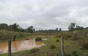
7 Current state -
8 Methodology At the local scale, how to map ES?

 - DEM ASTER (elevation, slope, topography and")
9 Methodology At the local scale, how to map ES? Field data: - ES indicators Remote sensing data: - Landsat TM (current and temporal landcover, NDVI and NDWI) - DEM ASTER (elevation, slope, topography and distance to water)
10 Results Respond variable R² Main predictive variables Vegetation carbon stocks 0.71 Current land cover, site Rates of water infiltration into the soil 0.57 Historical land cover trajectory, land cover Soil chemical quality index 0.67 NDWI, land cover, site Biodiversity index 0.65 NDVI, Site, distance to rivers
11 Results Respond variable R² Main predictive variables Vegetation carbon stocks 0.71 Current land cover, site Rates of water infiltration into the soil 0.57 Historical land cover trajectory, land cover Soil chemical quality index 0.67 NDWI, land cover, site Biodiversity index 0.65 NDVI, Site, distance to rivers

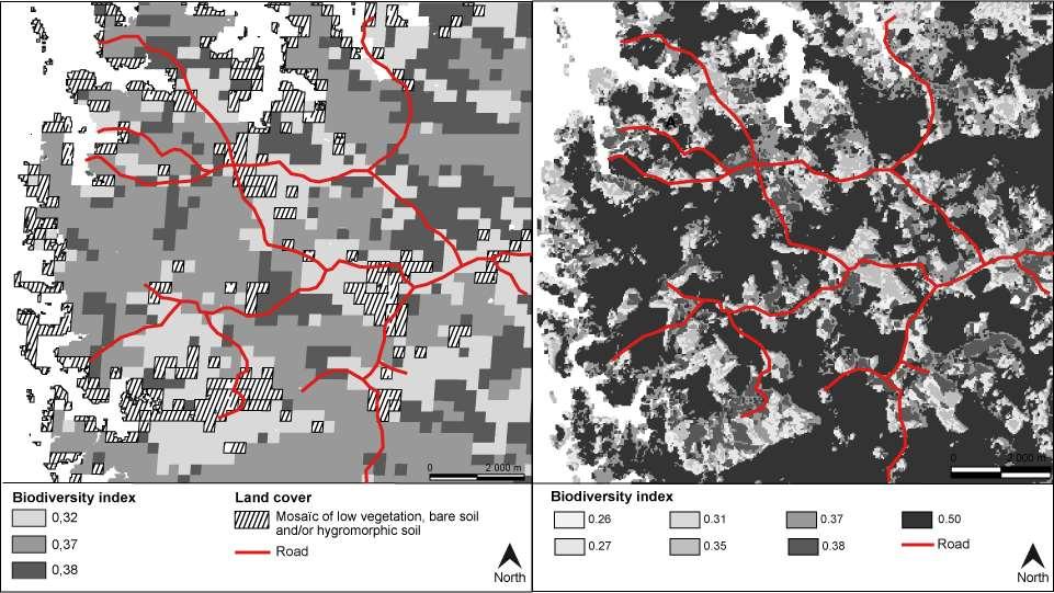
12 Results Biodiversity index Complexity of the phenomenum Importance of land cover changes Effects of other factors

13 Results Biodiversity index Patch of forest Pastures Effect of topography High values Low values
14 Current state -
15 Methodology At the regional scale, how to map ES?
16 Methodology At the regional scale, how to map ES? Field & High spatial resolution remote sensing data Statistical model Local ES maps
17 Methodology At the regional scale, how to map ES? Field & High spatial resolution remote sensing data Field & Moderate resolution remote sensing data Statistical model Mean for each ES per land cover type Local ES maps Regional ES maps
18 Methodology At the regional scale, how to map ES? Field & High spatial resolution remote sensing data Field & Moderate resolution remote sensing data Validation Statistical model Mean for each ES per land cover type Validation Local ES maps Validation Regional ES maps

19 Methodology At the regional scale, how to map ES? Field & High spatial resolution remote sensing data Field & Moderate resolution remote sensing data Field data: - ES indicators Remote sensing data: Validation - MODIS time-serie (250 x 250m) Statistical model Mean for each ES per land cover type Validation Maçaranduba Local ES maps Validation Regional ES maps
20 Results Carbon

21 Results Carbon Biodiversity
22 Results Prediction variability Carbon


23 Gradient in the landscape Results Transition areas Carbon Soil


24 - local scale
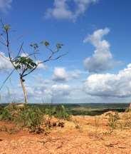
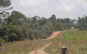
25 Methodology Stock or storage? Example of the vegetation carbon stocks Maçaranduba study site Stock: static state, applicable at a specific time Storage/destorage: dynamic process

26 Methodology Stock or storage? Example of the vegetation carbon stocks Maçaranduba study site Transect with an agricutural opening

27 Results Stock or storage? Example of the vegetation carbon stocks Maçaranduba study site dynamics
28 , conclusions
29 Unequal capacity to map ES, whatever the spatial scale they are represented at Simplification due to the lack of available data However, spatialized information at two decision levels + uncertainty estimation Low cost and highly reproducible methodology
30 Regional information to get a general overview Accurate local information to complete it ES temporal evolution to facilitate the implementation of environmental mitigation policies
31 Educational Understanding the social dependance to ecosystems Heuristic Reflexion on the exercice of mapping and on the notion itself Ecosystem services and their mapping All maps Political /policies Operational Quantitativist approach : tool to evaluate policies Qualitative approach : tool to bring and lead public debate and temporal analyses


32 Spatial and temporal modelling of ecosystem services Thanks for your attention! ACES Conference 2016 Jacksonville, Florida (USA). December, 5-9 th
Mapping ecosystem services trade-offs and synergies in a pioneer front context (Brazil)
") Mapping ecosystem services trade-offs and synergies in a pioneer front context (Brazil) Solen Le Clec h, Johan Oszwald, Thibaud Decaens, Simon Dufour, Michel Grimaldi, Nicolas Jégou, and Patrick Lavelle
Mapping ecosystem services trade-offs and synergies in a pioneer front context (Brazil) Solen Le Clec h, Johan Oszwald, Thibaud Decaens, Simon Dufour, Michel Grimaldi, Nicolas Jégou, and Patrick Lavelle
«Desertification and Drought Monitoring in Arid Tunisia based on Remote Sensing Imagery» Research Undertaken & Case-Studies.
 «Desertification and Drought Monitoring in Arid Tunisia based on Remote Sensing Imagery» Research Undertaken & Case-Studies EU COST Action September 2015, Antalya Turkey Bouajila ESSIFI INSTITUT DES REGIONS
Update ecosystem services analysis in SEEA Experimental Ecosystem Accounting
 Update ecosystem services analysis in SEEA Experimental Ecosystem Accounting Prof. Dr Lars Hein, Wageningen University With materials produced by or in collaboration with CBS, Statistics the Netherlands
Millennium Ecosystem Assessment
 Millennium Ecosystem Assessment Global Data Challenges from an MA perspective Global Spatial Data and Information User Workshop 21-23 September 2004! What is the MA?! How and what kinds of data does it
Lesson 4b Remote Sensing and geospatial analysis to integrate observations over larger scales
 Lesson 4b Remote Sensing and geospatial analysis to integrate observations over larger scales We have discussed static sensors, human-based (participatory) sensing, and mobile sensing Remote sensing: Satellite
Advanced Image Analysis in Disaster Response
 Advanced Image Analysis in Disaster Response Creating Geographic Knowledge Thomas Harris ITT The information contained in this document pertains to software products and services that are subject to the
Applications of GIS and Remote Sensing for Analysis of Urban Heat Island
 Chuanxin Zhu Professor Peter V. August Professor Yeqiao Wang NRS 509 December 15, 2016 Applications of GIS and Remote Sensing for Analysis of Urban Heat Island Since the last century, the global mean surface
GEO 874 Remote Sensing. Zihan Lin, Nafiseh Hagtalab, Ranjeet John
 GEO 874 Remote Sensing Zihan Lin, Nafiseh Hagtalab, Ranjeet John http://onlinelibrary.wiley.com/doi/10.1002/wat2.1147/full Landscape Heterogeneity S-I: homogeneous landscape using only cropland for the
Transboundary water management with Remote Sensing. Oluf Jessen DHI Head of Projects, Water Resources Technical overview
 Transboundary water management with Remote Sensing Oluf Jessen DHI Head of Projects, Water Resources Technical overview ozj@dhigroup.com Transboundary water management Water management across national
World Geography. WG.1.1 Explain Earth s grid system and be able to locate places using degrees of latitude and longitude.
 Standard 1: The World in Spatial Terms Students will use maps, globes, atlases, and grid-referenced technologies, such as remote sensing, Geographic Information Systems (GIS), and Global Positioning Systems
Global Land Project: major scientific questions for coupled modelling
 Global Land Project: major scientific questions for coupled modelling Richard Aspinall Macaulay Land Use Research Institute and GLP Nodal Office on Integration and Modelling Aberdeen, Scotland NATO Advanced
Data sources and classification for ecosystem accounting g
 Data sources and classification for ecosystem accounting Ken Bagstad 23 February 2015 Wealth Accounting and the Valuation of Ecosystem Services www.wavespartnership.org Data sources and classification
Ecological Site Description Overview
 Ecological Site Description Overview 2018 Coastal Zone Soil Survey (CZSS) Work Planning Conference Savannah, GA January 9th, 2018 Greg Taylor Senior Regional Soil Scientist USDA-NRCS Raleigh, NC j.greg.taylor@nc.usda.gov
Assessment and valuation of Ecosystem Services for decision-makers
 Assessment and valuation of Ecosystem Services for decision-makers An introduction to the ARIES approach Ferdinando Villa *, Ken Bagstad Gary Johnson, Marta Ceroni *Basque Center for Climate Change, Bilbao,
Land Accounts - The Canadian Experience
 Land Accounts - The Canadian Experience Development of a Geospatial database to measure the effect of human activity on the environment Who is doing Land Accounts Statistics Canada (national) Component
Global SoilMappingin a Changing World
 Global SoilMappingin a Changing World Sabine Grunwald Acknowledgements: GIS-Pedometrics Team, UF Soil Story My soil story. Your soil story Digital Soil Mapping in a Changing World Global climate change,
1 INTRODUCTION. 1.1 Context
 1 INTRODUCTION 1.1 Context During the last 30 years ski run construction has been one of the major human activities affecting the Alpine environment. The impact of skiing on environmental factors and processes,
New Frameworks for Urban Sustainability Assessments: Linking Complexity, Information and Policy
 New Frameworks for Urban Sustainability Assessments: Linking Complexity, Information and Policy Moira L. Zellner 1, Thomas L. Theis 2 1 University of Illinois at Chicago, Urban Planning and Policy Program
CLIMATE RESILIENT ALTITUDINAL GRADIENTS (CRAGs)
") CLIMATE RESILIENT ALTITUDINAL GRADIENTS (CRAGs) BUILDING CLIMATE CHANGE RESILIENCE IN THE KIVU- RUSIZI WATERSHEDS Great Lake Conference Entebbe 2017 Chris Magero WHAT ARE CRAGs? Climate-Resilient Altitudinal
CLIMATE RESILIENT ALTITUDINAL GRADIENTS (CRAGs) BUILDING CLIMATE CHANGE RESILIENCE IN THE KIVU- RUSIZI WATERSHEDS Great Lake Conference Entebbe 2017 Chris Magero WHAT ARE CRAGs? Climate-Resilient Altitudinal
INDIANA ACADEMIC STANDARDS FOR SOCIAL STUDIES, WORLD GEOGRAPHY. PAGE(S) WHERE TAUGHT (If submission is not a book, cite appropriate location(s))
 WHERE TAUGHT (If submission is not a book, cite appropriate location(s))") Prentice Hall: The Cultural Landscape, An Introduction to Human Geography 2002 Indiana Academic Standards for Social Studies, World Geography (Grades 9-12) STANDARD 1: THE WORLD IN SPATIAL TERMS Students
Prentice Hall: The Cultural Landscape, An Introduction to Human Geography 2002 Indiana Academic Standards for Social Studies, World Geography (Grades 9-12) STANDARD 1: THE WORLD IN SPATIAL TERMS Students
Fig 1. Steps in the EcoValue Project
 Assessing the Social and Economic Value of Ecosystem Services in the Northern Forest Region: A Geographic Information System (GIS) Approach to Landscape Valuation Principal Investigator(s): Dr. Matthew
Mapping for a Changing California
 Mapping for a Changing California Spatial Data Science: - the 21 st century mapping toolkit - case studies in remote sensing and participatory informatics -where to get more information Maggi Kelly, University
DEVELOPMENT AND APPLICATION OF HIGH- RESOLUTION GIS-BASED ATLAS TO ENHANCE WATERSHED MANAGEMENT IN THE PHILIPPINES
 DEVELOPMENT AND APPLICATION OF HIGH- RESOLUTION GIS-BASED ATLAS TO ENHANCE WATERSHED MANAGEMENT IN THE PHILIPPINES Nathaniel C. Bantayan Institute of Renewable Natural Resources College of Forestry and
Framework for the Basin-Wide Socio-Economic Analysis of Four Proposed Sediment Diversions. August 4, 2015
 Framework for the Basin-Wide Socio-Economic Analysis of Four Proposed Sediment Diversions August 4, 2015 Proposed Sediment Diversions Mid-Breton Mid-Barataria Lower Barataria Lower Breton Overview of Presentation
COMMON CONCEPTUAL AND OPERATIONAL FRAMEWORKS FOR RESEARCH AND SUSTAINABLE MANAGEMENT OF NESTED SOCIO-ECOLOGICAL SYSTEMS ACROSS LARGE WATERSHEDS
 COMMON CONCEPTUAL AND OPERATIONAL FRAMEWORKS FOR RESEARCH AND SUSTAINABLE MANAGEMENT OF NESTED SOCIO-ECOLOGICAL SYSTEMS ACROSS LARGE WATERSHEDS Angheluta VADINEANU 1 & Nusret KARAKAYA 2 1 Department of
Land Account : Indonesia
 Land Account : Indonesia Outline Environmental concerns Approach in compiling land account Results: Sumatera Land Account, Experimental Estimates Challenges Policy applications Further work Environmental
Training on national land cover classification systems. Toward the integration of forest and other land use mapping activities.
 Training on national land cover classification systems Toward the integration of forest and other land use mapping activities. Guiana Shield 9 to 13 March 2015, Paramaribo, Suriname Background Sustainable
Spatial Modeling Approaches & Considerations Class #12. Major Elements: Complexity Theory. Complexity Theory: Theoretical Context
 Spatial Modeling Approaches & Considerations Class #12 Complexity theory Non linear system dynamics Emergence Complex adaptive systems Spatial simulations What if scenarios Extend in space & time and conditions
THE EFFECTS OF CLIMATE CHANGE ON THE TOURISM INDUSTRY IN SOUTHEAST ASIA WITH A SPECIFIC ANALYSIS OF THE CASE OF PATTAYA, THAILAND
 i THE EFFECTS OF CLIMATE CHANGE ON THE TOURISM INDUSTRY IN SOUTHEAST ASIA WITH A SPECIFIC ANALYSIS OF THE CASE OF PATTAYA, THAILAND Name School Course Date ii Abstract Climate change has already made an
Modeling the Change of Mangrove Forests in Irrawaddy Delta, South Myanmar
 International Journal of Sciences: Basic and Applied Research (IJSBAR) ISSN 2307-4531 (Print & Online) http://gssrr.org/index.php?journal=journalofbasicandapplied ---------------------------------------------------------------------------------------------------------------------------
Georeferencing and Satellite Image Support: Lessons learned, Challenges and Opportunities
 Georeferencing and Satellite Image Support: Lessons learned, Challenges and Opportunities Shirish Ravan shirish.ravan@unoosa.org UN-SPIDER United Nations Office for Outer Space Affairs (UNOOSA) UN-SPIDER
EcoServ-GIS. Ecosystem Services Mapping: A Wildlife Trust GIS Toolkit to map ecosystem services at a county scale
 EcoServ-GIS Ecosystem Services Mapping: A Wildlife Trust GIS Toolkit to map ecosystem services at a county scale Dr Jonathan Winn Living Landscape Coordinator Durham Wildlife Trust Dr Chloe Bellamy Ecosystem
A land management decision support tool and ecosystem process modelling framework
 A land management decision support tool and ecosystem process modelling framework Bethanna Jackson, Bridget Emmett, David Cooper, Lindsay Maskell, + more Services currently modelled by LUCI Service Production
GIS Solutions in Natural Resource Management: Balancing the Technical- Political Equation
 GIS Solutions in Natural Resource Management: Balancing the Technical- Political Equation Stan Morain, Editor SUB Gdttlngen 7 208 520 309 98 A14447 0NW0RD PRESS V? % \
Greening of Arctic: Knowledge and Uncertainties
 Greening of Arctic: Knowledge and Uncertainties Jiong Jia, Hesong Wang Chinese Academy of Science jiong@tea.ac.cn Howie Epstein Skip Walker Moscow, January 28, 2008 Global Warming and Its Impact IMPACTS
Spatial information in strategic city planning - Zagreb experience. Darko Šiško City office for strategic planning, Zagreb
 Spatial information in strategic city planning - Zagreb experience Darko Šiško City office for strategic planning, Zagreb Overview Strategic city planning GI tools and trends Spatial data for strategic
Thomas Koellner 1, Adrienne Grét-Regamey 1, Miguel Marchamalo 2, and Raffaele Vignola 3. ETH Zurich, Switzerland. Polytecnica Madrid, Spain
 Thomas Koellner 1, Adrienne Grét-Regamey 1, Miguel Marchamalo 2, and Raffaele Vignola 3 1 ETH Zurich, Switzerland 2 Polytecnica Madrid, Spain 3 CATIE, Costa Rica Our concept of human-environment systems
Tropics & Sub-Tropics. How can predictive approaches be improved: Data Sparse Situations
 Tropics & Sub-Tropics How can predictive approaches be improved: Data Sparse Situations 1. Protocol for catchment function diagnostics and model setup. Use of a decision tree as a preliminary stage to
Dynamic Land Cover Dataset Product Description
 Dynamic Land Cover Dataset Product Description V1.0 27 May 2014 D2014-40362 Unclassified Table of Contents Document History... 3 A Summary Description... 4 Sheet A.1 Definition and Usage... 4 Sheet A.2
1. Introduction. Jai Kumar, Paras Talwar and Krishna A.P. Department of Remote Sensing, Birla Institute of Technology, Ranchi, Jharkhand, India
 Cloud Publications International Journal of Advanced Remote Sensing and GIS 2015, Volume 4, Issue 1, pp. 1026-1032, Article ID Tech-393 ISSN 2320-0243 Research Article Open Access Forest Canopy Density
Progress Report Year 2, NAG5-6003: The Dynamics of a Semi-Arid Region in Response to Climate and Water-Use Policy
 Progress Report Year 2, NAG5-6003: The Dynamics of a Semi-Arid Region in Response to Climate and Water-Use Policy Principal Investigator: Dr. John F. Mustard Department of Geological Sciences Brown University
Overview of Remote Sensing in Natural Resources Mapping
 Overview of Remote Sensing in Natural Resources Mapping What is remote sensing? Why remote sensing? Examples of remote sensing in natural resources mapping Class goals What is Remote Sensing A remote sensing
Term Knowledge Using and applying Grade Criteria Autumn 1 Assessment window October Natural hazards pose major risks to people and property.
 Assessment Schedule Year 9 2015/6 Term Knowledge Using and applying Grade Criteria Autumn 1 Assessment window October 2015 3.1.1.2 Tectonic Natural hazards pose major risks to people and property. Definition
Landuse and Landcover change analysis in Selaiyur village, Tambaram taluk, Chennai
 Landuse and Landcover change analysis in Selaiyur village, Tambaram taluk, Chennai K. Ilayaraja Department of Civil Engineering BIST, Bharath University Selaiyur, Chennai 73 ABSTRACT The synoptic picture
DC Educational Standards Science Grade: 6 - Adopted: Matter and Its Interactions
 Main Criteria: DC Educational Standards Secondary Criteria: Subjects: Science, Social Studies Grade: 6 Correlation Options: Show Correlated ESSENTIAL DC.MS-PS. MS-PS1. DC Educational Standards Science
An Automated Object-Oriented Satellite Image Classification Method Integrating the FAO Land Cover Classification System (LCCS).
.") An Automated Object-Oriented Satellite Image Classification Method Integrating the FAO Land Cover Classification System (LCCS). Ruvimbo Gamanya Sibanda Prof. Dr. Philippe De Maeyer Prof. Dr. Morgan De
An Automated Object-Oriented Satellite Image Classification Method Integrating the FAO Land Cover Classification System (LCCS). Ruvimbo Gamanya Sibanda Prof. Dr. Philippe De Maeyer Prof. Dr. Morgan De
2013 Esri Europe, Middle East and Africa User Conference October 23-25, 2013 Munich, Germany
 2013 Esri Europe, Middle East and Africa User Conference October 23-25, 2013 Munich, Germany Environmental and Disaster Management System in the Valles Altos Region in Carabobo / NW-Venezuela Prof.Dr.habil.Barbara
Mapping of ecosystems and their services in the EU and its Member States
 Mapping of ecosystems and their services in the EU and its Member States Leon C. Braat, Alterra, Wageningen, The Netherlands MESEU Brussels, July 1, 2015 MESEU FINAL REPORT OCTOBER 2015 The Objective :
EcoServ-GIS. EcoServ GIS Stage I. Why EcoServ GIS? 17/12/2012
 EcoServ-GIS Ecosystem Services Mapping: A Wildlife Trust GIS Toolkit to map ecosystem services at a county scale Dr Jonathan Winn Living Landscape Coordinator Durham Wildlife Trust Dr Chloe Bellamy Ecosystem
Biodiversity Blueprint Overview
 Biodiversity Blueprint Overview Climate Variability Climate projections for the Glenelg Hopkins Regions suggest that the weather will be hotter and drier in the coming years which will impact on land use,
Ecological Response Units Ecosystem Mapping System for the Southwest US
 Ecological Response Units Ecosystem Mapping System for the Southwest US J. C. Moreland, W. A. Robbie, F. J. Triepke, E. H. Muldavin, and J. R. Malusa Objectives What are Ecological Response Units? What
Spatio-temporal models
 Spatio-temporal models Involve a least a three dimensional representation of one or more key attribute variation in planar (X-Y) space and through time. (a 4 th dimension could also be use, like Z for
Snow processes and their drivers in Sierra Nevada (Spain), and implications for modelling.
, and implications for modelling.") Snow processes and their drivers in Sierra Nevada (Spain), and implications for modelling. M.J. Polo, M.J. Pérez-Palazón, R. Pimentel, J. Herrero Granada,02 de November 2016 SECTIONS 1. 2. 3. 4. 5. Introduction
Snow processes and their drivers in Sierra Nevada (Spain), and implications for modelling. M.J. Polo, M.J. Pérez-Palazón, R. Pimentel, J. Herrero Granada,02 de November 2016 SECTIONS 1. 2. 3. 4. 5. Introduction
Indices and Indicators for Drought Early Warning
 Indices and Indicators for Drought Early Warning ADRIAN TROTMAN CHIEF, APPLIED METEOROLOGY AND CLIMATOLOGY CARIBBEAN INSTITUTE FOR METEOROLOGY AND HYDROLOGY IN COLLABORATION WITH THE NATIONAL DROUGHT MITIGATION
VISUALIZATION URBAN SPATIAL GROWTH OF DESERT CITIES FROM SATELLITE IMAGERY: A PRELIMINARY STUDY
 CO-439 VISUALIZATION URBAN SPATIAL GROWTH OF DESERT CITIES FROM SATELLITE IMAGERY: A PRELIMINARY STUDY YANG X. Florida State University, TALLAHASSEE, FLORIDA, UNITED STATES ABSTRACT Desert cities, particularly
Soil Erosion Calculation using Remote Sensing and GIS in Río Grande de Arecibo Watershed, Puerto Rico
 Soil Erosion Calculation using Remote Sensing and GIS in Río Grande de Arecibo Watershed, Puerto Rico Alejandra M. Rojas González Department of Civil Engineering University of Puerto Rico at Mayaguez.
Land Accounts in Canada
 Land Accounts in Canada 22 nd meeting of the London Group September 29 th, 2016 Statistics Norway, Oslo Gabriel Gagnon Statistics Canada Land accounts in Canada OVERVIEW Context Strategic direction Latest
GCOS High Resolution Land Cover ECV. Slide 11
 GCOS High Resolution Land Cover ECV Slide 11 Detailed Land Cover and Climate Land cover and its changes modify the goods and services provided to human society force climate by altering water and energy
Eco-hydromorphic Characterization of the Louisiana Coastal Region Using Multiple Remotely Sensed Data Sources and Analyses
 National Wetlands Research Center Eco-hydromorphic Characterization of the Louisiana Coastal Region Using Multiple Remotely Sensed Data Sources and Analyses 1Holly Beck, 2 Brady Couvillion, 1 Nadine Trahan
GGY 301: Research Methods
 GGY 301: Research Methods Course No GGY 301 Course Title Research Methods Core/Optional Core for Special Degree :This course provides students with a basic knowledge and understanding of the research methodology
DEVELOP National Program
 DEVELOP National Program GLSLCI 2015 Annual Meeting and Conference Sarnia, Ontario 19 June 2015 DEVELOP National Program NASA GLSLCI 2015 June 2015 NASA Earth observations NASA Earth observations include
OSS MISSION.
 GEO-CRADLE COORDINATING AND INTEGRATING STATE-OF-THE-ART EARTH OBSERVATION ACTIVITIES IN THE REGION OF NORTH OF AFRICA, MIDDLE EAST, AND BALKANS AND DEVELOPING LINKS WITH GEO RELATED INITIATIVES TOWARD
AGOG 485/585 /APLN 533 Spring Lecture 5: MODIS land cover product (MCD12Q1). Additional sources of MODIS data
. Additional sources of MODIS data") AGOG 485/585 /APLN 533 Spring 2019 Lecture 5: MODIS land cover product (MCD12Q1). Additional sources of MODIS data Outline Current status of land cover products Overview of the MCD12Q1 algorithm Mapping
AGOG 485/585 /APLN 533 Spring 2019 Lecture 5: MODIS land cover product (MCD12Q1). Additional sources of MODIS data Outline Current status of land cover products Overview of the MCD12Q1 algorithm Mapping
Biodiversität und Fernerkundung im Skalierungskontext des BrahmaTWinn-Projektes
 Biodiversität und Fernerkundung im Skalierungskontext des BrahmaTWinn-Projektes Norbert Exler - Iris Wagner - Georg Janauer 6th EU Framework Programme Priority: Global Change and Ecosystems Contract: No.
Pacemaker World Geography and Cultures. correlated to. Louisiana Social Studies Grade Level Expectations: World Geography Geography Grades 9-12
 Pacemaker World and Cultures correlated to Louisiana Social Studies Grade Level Expectations: World Grades 9-12 Pacemaker World and Cultures Pearson Learning Group correlated to Louisiana Social Studies
Transactions on Information and Communications Technologies vol 18, 1998 WIT Press, ISSN
 STREAM, spatial tools for river basins, environment and analysis of management options Menno Schepel Resource Analysis, Zuiderstraat 110, 2611 SJDelft, the Netherlands; e-mail: menno.schepel@resource.nl
The UN-GGIM: Europe core data initiative to encourage Geographic information supporting Sustainable Development Goals Dominique Laurent, France
 INSPIRE conference Strasbourg 6 September 2017 The UN-GGIM: Europe core data initiative to encourage Geographic information supporting Sustainable Development Goals Dominique Laurent, France Introduction
Delineation of Groundwater Potential Zone on Brantas Groundwater Basin
 Delineation of Groundwater Potential Zone on Brantas Groundwater Basin Andi Rachman Putra 1, Ali Masduqi 2 1,2 Departement of Environmental Engineering, Sepuluh Nopember Institute of Technology, Indonesia
Seymour Centre 2017 Education Program 2071 CURRICULUM LINKS
 Suitable for: Stage 5 Stage 6 HSC Subject Links: Seymour Centre 2017 Education Program 2071 CURRICULUM LINKS Science Stage Content Objective Outcomes Stage 5 Earth and Space ES3: People use scientific
Regional Plan 4: Integrating Ecosystem Services Mapping into Regional Land Use Planning
 Rural-Urban Outlooks: Unlocking Synergies (ROBUST) ROBUST receives funding from the European Union s Horizon 2020 research and innovation programme under grant agreement No 727988.* October 2018 Natural
The Role of Wilderness in Climate Change Adaptation
 The Role of Wilderness in Climate Change Adaptation A Case Study of the Northern Rockies Greg Aplet, Bo Wilmer Goal: Sustaining Ecosystem Services Sustaining the full suite of benefits we receive from
CHANGE DETECTION USING REMOTE SENSING- LAND COVER CHANGE ANALYSIS OF THE TEBA CATCHMENT IN SPAIN (A CASE STUDY)
") CHANGE DETECTION USING REMOTE SENSING- LAND COVER CHANGE ANALYSIS OF THE TEBA CATCHMENT IN SPAIN (A CASE STUDY) Sharda Singh, Professor & Programme Director CENTRE FOR GEO-INFORMATICS RESEARCH AND TRAINING
CHANGE DETECTION USING REMOTE SENSING- LAND COVER CHANGE ANALYSIS OF THE TEBA CATCHMENT IN SPAIN (A CASE STUDY) Sharda Singh, Professor & Programme Director CENTRE FOR GEO-INFORMATICS RESEARCH AND TRAINING
Environmental Changes, Migration, and Remittances Affect Pastoralist Communities in Montane Central Asia
 Environmental Changes, Migration, and Remittances Affect Pastoralist Communities in Montane Central Asia Geoffrey M. Henebry * Hannah Visiting Professor Center for Global Change & Earth Observations &
Droughts are normal recurring climatic phenomena that vary in space, time, and intensity. They may affect people and agriculture at local scales for
 I. INTRODUCTION 1.1. Background Droughts are normal recurring climatic phenomena that vary in space, time, and intensity. They may affect people and agriculture at local scales for short periods or cover
Jim Fox. copyright UNC Asheville's NEMAC
 Decisions and System Thinking Jim Fox November, 2012 1 UNC Asheville s s NEMAC National Environmental Modeling and Analysis Center Applied Research and technology development on integration of environmental
16540/14 EE/cm 1 DG E 1A
 Council of the European Union Brussels, 5 December 2014 (OR. en) 16540/14 ENV 965 CULT 139 NOTE From: To: Subject: General Secretariat of the Council Delegations Charter of Rome on Natural and Cultural
Scientific registration n : 2180 Symposium n : 35 Presentation : poster MULDERS M.A.
 Scientific registration n : 2180 Symposium n : 35 Presentation : poster GIS and Remote sensing as tools to map soils in Zoundwéogo (Burkina Faso) SIG et télédétection, aides à la cartographie des sols
Note on Definition of Socio-Ecological Landscape Unit, SELU Classification and its Policy Application
 Note on Definition of Socio-Ecological Landscape Unit, SELU Classification and its Policy Application Alessandra Alfieri, Daniel Clarke and Ivo Havinga, United Nations Statistics Division and Jean Louis
Rural Sociology (RU_SOC)
") Rural Sociology (RU_SOC) 1 Rural Sociology (RU_SOC) RU_SOC 1000: Rural Sociology Introduction to basic concepts and principles of sociology with a focus on rural populations and places. The course explores
Rural Sociology (RU_SOC) 1 Rural Sociology (RU_SOC) RU_SOC 1000: Rural Sociology Introduction to basic concepts and principles of sociology with a focus on rural populations and places. The course explores
Canadian Geo Course Introduction
 Canadian Geo 1202 Course Introduction Course Overview Unit 1 Natural and Human Systems (SCO 1.0 and SCO 2.0) - What happens when systems interact? In this unit students are challenged to reflect on the
Spatial Disaggregation of Land Cover and Cropping Information: Current Results and Further steps
 CAPRI CAPRI Spatial Disaggregation of Land Cover and Cropping Information: Current Results and Further steps Renate Koeble, Adrian Leip (Joint Research Centre) Markus Kempen (Universitaet Bonn) JRC-AL
Shared Knowledge for Decision-Making on Environment and Health Issues in the Arctic
 Shared Knowledge for Decision-Making on Environment and Health Issues in the Arctic RADARSAT Global View of the Arctic Ocean Credit : NASA JPL, University of Alaska - Fairbanks Nancy G. Maynard, Ph.D.
Geography General Course Year 12. Selected Unit 3 syllabus content for the. Externally set task 2019
 Geography General Course Year 12 Selected Unit 3 syllabus content for the Externally set task 2019 This document is an extract from the Geography General Course Year 12 syllabus, featuring all of the content
VCS MODULE VMD0018 METHODS TO DETERMINE STRATIFICATION
 VMD0018: Version 1.0 VCS MODULE VMD0018 METHODS TO DETERMINE STRATIFICATION Version 1.0 16 November 2012 Document Prepared by: The Earth Partners LLC. Table of Contents 1 SOURCES... 2 2 SUMMARY DESCRIPTION
Plenary Session 2, part 2 A European shared information system
 3 rd GMES Forum 5 6 June 2003 Athens Plenary Session 2, part 2 A European shared information system Gordon McInnes Deputy Director European Environment Agency 1 I keep six honest serving men. They taught
Mapping Ecosystem Services: Current Trends
 Mapping Ecosystem Services: Current Trends Ignacio Palomo, Berta Martín-López, Carlos Montes Social Ecological Systems Laboratory Department of Ecology Universidad Autónoma de Madrid ACES 2008: A Conference
Minnesota K-12 Academic Standards in Social Studies. Grade 4: Geography of North America
 Minnesota K-12 Academic s in Social Studies Grade 4: Geography of North America 4 Describe how people take 1. Democratic government action to influence a depends on informed and decision on a specific
European Space Agency
 Guidelines - Guidelines how/when to interact during the WebEx session: - Due to the number of attendees, please keep always your webcam and microphone switched-off - You can use anytime the chat to all
The Influence of Historical and Projected Land Use and Land Cover Changes on Land Surface Hydrology and Regional Weather and Climate Variability
 The Influence of Historical and Projected Land Use and Land Cover Changes on Land Surface Hydrology and Regional Weather and Climate Variability Research Hypothesis: Land use and land cover changes are
Arctic Tundra land cover and biomass change on the Central Yamal peninsula, Russia
 Arctic Tundra land cover and biomass change on the Central Yamal peninsula, Russia ArcticBiomass Workshop, 20-23 Ocrobertember 2015, Svalbard Kumpula, T.*, Verdonen, M*., Macias-Fauria, M***, Skarin A.****
Uses of free satellite imagery for Disaster Risk Reduction (DRR)
") Centre of Applied Geoscience, Disaster Risk Reduction Research Group, School of Earth and Environmental Science, University of Portsmouth, UK Uses of free satellite imagery for Disaster Risk Reduction
Centre of Applied Geoscience, Disaster Risk Reduction Research Group, School of Earth and Environmental Science, University of Portsmouth, UK Uses of free satellite imagery for Disaster Risk Reduction
Comparing the Land Use and Land Cover Changes Between the North and South Louisiana Using Data Mining
 Comparing the Land Use and Land Cover Changes Between the North and South Louisiana Using Data Mining Yi Qiang and Nina Lam Department of Environmental Sciences Louisiana State University yqiang1@lsu.edu,
National Disaster Management Centre (NDMC) Republic of Maldives. Location
 Republic of Maldives. Location") National Disaster Management Centre (NDMC) Republic of Maldives Location Country Profile 1,190 islands. 198 Inhabited Islands. Total land area 300 sq km Islands range b/w 0.2 5 sq km Population approx.
National Disaster Management Centre (NDMC) Republic of Maldives Location Country Profile 1,190 islands. 198 Inhabited Islands. Total land area 300 sq km Islands range b/w 0.2 5 sq km Population approx.
Signal, Noise, and Recognition: Changing Weather Patterns in Oklahoma
 Signal, Noise, and Recognition: Changing Weather Patterns in Oklahoma Hank Jenkins-Smith, Carol Silva, and Joseph Ripberger National Institute for Risk and Resilience University of Oklahoma What do we
DROUGHT ASSESSMENT USING SATELLITE DERIVED METEOROLOGICAL PARAMETERS AND NDVI IN POTOHAR REGION
 DROUGHT ASSESSMENT USING SATELLITE DERIVED METEOROLOGICAL PARAMETERS AND NDVI IN POTOHAR REGION Researcher: Saad-ul-Haque Supervisor: Dr. Badar Ghauri Department of RS & GISc Institute of Space Technology
Existing NWS Flash Flood Guidance
 Introduction The Flash Flood Potential Index (FFPI) incorporates physiographic characteristics of an individual drainage basin to determine its hydrologic response. In flash flood situations, the hydrologic
Drought Estimation Maps by Means of Multidate Landsat Fused Images
 Remote Sensing for Science, Education, Rainer Reuter (Editor) and Natural and Cultural Heritage EARSeL, 2010 Drought Estimation Maps by Means of Multidate Landsat Fused Images Diego RENZA, Estíbaliz MARTINEZ,
REMOTE SENSING FOR MEGACITIES RESEARCH
 1st EARSeL Workshop of the SIG Urban Remote Sensing 1 REMOTE SENSING FOR MEGACITIES RESEARCH Maik Netzband 1, Ellen Banzhaf 1 and Ulrike Weiland 1 1. Center for Environmental Research Leipzig-Halle GmbH,
Kyoto and Carbon Initiative - the Ramsar / Wetlands International perspective
 Kyoto and Carbon Initiative - the Ramsar / Wetlands International perspective (the thoughts of Max Finlayson, as interpreted by John Lowry) Broad Requirements Guideline(s) for delineating wetlands (specifically,
GIS and Remote Sensing
 Spring School Land use and the vulnerability of socio-ecosystems to climate change: remote sensing and modelling techniques GIS and Remote Sensing Katerina Tzavella Project Researcher PhD candidate Technology