The Role of Wilderness in Climate Change Adaptation
|
|
|
- Joan Paul
- 5 years ago
- Views:
Transcription
1 The Role of Wilderness in Climate Change Adaptation A Case Study of the Northern Rockies Greg Aplet, Bo Wilmer
2 Goal: Sustaining Ecosystem Services Sustaining the full suite of benefits we receive from wildlands. provisioning services (e.g., food, drug precursors, renewable energy) regulating services (e.g., carbon sequestration, waste decomposition, nutrient cycling) supporting services (e.g., water purification, crop pollination, pest control) cultural services (e.g., recreation, scientific discovery, spiritual inspiration) preserving services (e.g., biodiversity protection, hedging against uncertainty)
3 Sustainability: Old problem, new urgency Sustainability, by my definition, refers to maintenance of the potential for our land and water ecosystems to produce the same quantity and quality of goods and services in perpetuity. Preventing degradation of productive capacity. Preventing loss of biodiversity. J. F. Franklin (1993)
4 What do we mean by wildlands? Controlled Self-willed Urban Novel Wilderness Backcountry Frontcountry Rural Ecological Condition Pristine
5 The Land Use Gradient Controlled Self-willed C&O Canal Vacant Lot Downtown Chesapeake Bay Fire-excluded Ponderosa Pine Forest Pine Plantation Arctic Refuge Everglades Curtis Prairie Novel Pristine Ecological Condition
6 Directions of Management Controlled Self-willed Novel Pristine
7 Management Options Under Global Change Controlled Self-willed Novel Ecological Condition Pristine Pressure of Global Change Climate Change Invasive Species Pollution Fragmentation/Land-use
8 Adaptation One goal: Sustaining ecosystem services by maintaining productive capacity and biodiversity. A diversity of approaches: Resist Change Guide Change Accept Change A portfolio of adaptation and mitigation measures can diminish the risks associated with climate change. IPCC Adaptation Report
9 A Portfolio of Approaches: IUCN Protected Area Categories Category Ia: Category Ib: Category II: Category III: Category IV: Category V: Category VI: Strict nature reserve Wilderness area National park Natural monument Habitat / species management area Protected land/seascape Managed resource protected area
10 Treatment Constraints
11 A Balanced Allocation Ia. Strict Nature Preserve Ib. Wilderness Area II. National Park III. Natural Monument IV. Habitat Mgmt. Area V. Land/Seascape VI. Managed Resource Protected Area Unprotected
12 The Ideal Experimental Landscape Well balanced in area Evenly distributed across environmental gradients Well connected across environmental gradients Acres (1000s) >11000 Elevation (feet) VI V IV III III I
13 So, how balanced is our portfolio?

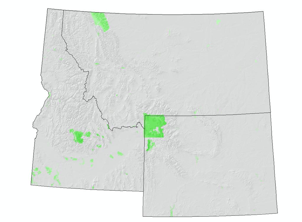
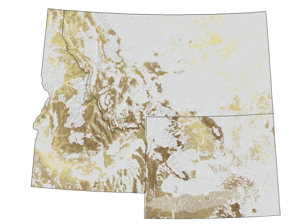
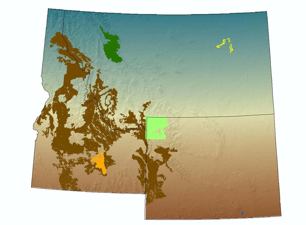
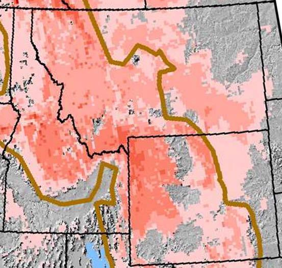
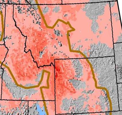
14 What about the Northern Rockies?

15 The Northern Rockies: A relative wealth of protected areas
16

17 Protected Area Balance in the Northern Rockies
18 Elevational Representation 18,000,000 16,000,000 14,000,000 12,000,000 Acres 10,000,000 8,000,000 Ia Ib II III IV V VI NA 6,000,000 4,000,000 2,000, Elevation
19 Ia
20 30.0% Category Ia. Strict Nature Reserves 25.0% 20.0% Full Range Ia 15.0% Best Connected Patch 10.0% 5.0% 0.0%
21 Ib
22 30.0% Category Ib. Wilderness Areas 25.0% 20.0% Full Range Ib 15.0% Best Connected Patch 10.0% 5.0% 0.0%
23 II
24 30.0% Category II: National Parks 25.0% 20.0% Full Range II 15.0% Best Connected Patch 10.0% 5.0% 0.0%
25 VI
26 Latitudinal Representation Acres Ia Ib II III IV V VI NA Latitude (degrees)
27
28
29 Conclusion: Northern Rockies Case Study A relative wealth of protected areas Not well balanced Some classes connect well across elevation All classes need latitudinal connectivity
30 Climate Change Adaptation and Wilderness An experimental approach with wilderness as one part One goal: Sustaining ecosystem services by preventing the loss of productive capacity and biodiversity Wilderness will play a critical role Humility, health, high elevation Better connectivity needed for all protected areas
WELCOME & INTRODUCTION
 MPA Management Capacity Building Training Module 1: WELCOME & INTRODUCTION Participants Distinguished Guests Welcome Site Overviews of MPAs represented Overview of Training Program What are Today s Objectives?
Most people used to live like this
 Urbanization Most people used to live like this Increasingly people live like this. For the first time in history, there are now more urban residents than rural residents. Land Cover & Land Use Land cover
Together towards a Sustainable Urban Agenda
 Together towards a Sustainable Urban Agenda The City We (Youth) Want Preliminary findings from youth consultations Areas Issue Papers Policy Units 1.Social Cohesion and Equity - Livable Cities 2.Urban
EcoServ-GIS. Ecosystem Services Mapping: A Wildlife Trust GIS Toolkit to map ecosystem services at a county scale
 EcoServ-GIS Ecosystem Services Mapping: A Wildlife Trust GIS Toolkit to map ecosystem services at a county scale Dr Jonathan Winn Living Landscape Coordinator Durham Wildlife Trust Dr Chloe Bellamy Ecosystem
Rainforests and Deserts: Distribution, Uses, and Human Influences. Teacher s Masters California Education and the Environment Initiative
 E Teacher s Masters California Education and the Environment Initiative Earth Science Standard E.5.e. Rainforests and Deserts: Distribution, Uses, and Human Influences California Education and the Environment
EcoServ-GIS. EcoServ GIS Stage I. Why EcoServ GIS? 17/12/2012
 EcoServ-GIS Ecosystem Services Mapping: A Wildlife Trust GIS Toolkit to map ecosystem services at a county scale Dr Jonathan Winn Living Landscape Coordinator Durham Wildlife Trust Dr Chloe Bellamy Ecosystem
European Topic Centre on Land Urban and Soil Systems. Green Infrastructure at EEA
 Green Infrastructure at EEA A SPATIAL APPROACH TO MAPPING GI Stefan Kleeschulte, ETC ULS GI and territorial cohesion 2011 first EEA report on Green Infrastructure Underlining the need to develop tools
3.3 Threats to Biodiversity
 Name: Date: Class: IB Environmental Systems and Societies 3.3 Threats to Biodiversity Significant ideas: While global biodiversity is difficult to quantify, it is decreasing rapidly due to human activity.
Framework for the Basin-Wide Socio-Economic Analysis of Four Proposed Sediment Diversions. August 4, 2015
 Framework for the Basin-Wide Socio-Economic Analysis of Four Proposed Sediment Diversions August 4, 2015 Proposed Sediment Diversions Mid-Breton Mid-Barataria Lower Barataria Lower Breton Overview of Presentation
The Sixth Extinction? Community effects on ecosystem processes CMM Chap The context: altered biodiversity. 2a. Loss of Global Biodiveristy:
 Community effects on ecosystem processes CMM Chap. 12 A.1. State factors and interactive controls: Species effects on interactive controls determine ecosystem consequences I. Introduction A. The context
Exploring the provision of ecosystem services through rural landscape management: a development of conceptual framework
 Exploring the provision of ecosystem services through rural landscape management: a development of conceptual framework Rovai M., Bartolini F., Fastelli L., Brunori G. Department of Agriculture, Food and
Landscape Planning and Habitat Metrics
 Landscape Planning and Habitat Metrics Frank W. Davis National Center for Ecological Analysis and Synthesis UC Santa Barbara (Tools for Landscape Biodiversity Planning) Jimmy Kagan Institute for Natural
Developing urban ecosystem accounts for Great Britain. Emily Connors Head of Natural Capital Accounting Office for National Statistics (UK)
") Developing urban ecosystem accounts for Great Britain Emily Connors Head of Natural Capital Accounting Office for National Statistics (UK) UN 2014 UN 2014 ONS 2017 UK motivation 54% 82% 5,900 Of the world
Developing urban ecosystem accounts for Great Britain Emily Connors Head of Natural Capital Accounting Office for National Statistics (UK) UN 2014 UN 2014 ONS 2017 UK motivation 54% 82% 5,900 Of the world
Unit 2: Ecology. Big Idea...
 Name: Block: Unit 2: Ecology Big Idea... The natural world is defined by organisms and life processes which conform to principles regarding conservation and transformation of matter and energy. Knowledge
Mapping and Assessment of Ecosystems and their Services
 Mapping and Assessment of Ecosystems and their Services ALTER-Net Conference 2013: Science underpinning the EU 2020 Biodiversity Strategy. April 2013 Gent Joachim MAES 1 This presentation is based on the
Goals: Be able to. Basic conflict: Economic opportunity vs. Environmental quality. Human population is growing exponentially
 Goals: Be able to Describe the general history of biodiversity and extinctions on Earth. Discuss why species go extinct. Explain why predators generally need larger land area than herbivores. Describe
SEEA Experimental Ecosystem Accounting
 SEEA Experimental Ecosystem Accounting Sokol Vako United Nations Statistics Division Training for the worldwide implementation of the System of Environmental Economic Accounting 2012 - Central Framework
The Diversity of Living Things
 The Diversity of Living Things Biodiversity When scientists speak of the variety of organisms (and their genes) in an ecosystem, they refer to it as biodiversity. A biologically diverse ecosystem, such
Local Area Key Issues Paper No. 13: Southern Hinterland townships growth opportunities
 Draft Sunshine Coast Planning Scheme Review of Submissions Local Area Key Issues Paper No. 13: Southern Hinterland townships growth opportunities Key Issue: Growth opportunities for Southern Hinterland
Mapping Ecosystem Services: Current Trends
 Mapping Ecosystem Services: Current Trends Ignacio Palomo, Berta Martín-López, Carlos Montes Social Ecological Systems Laboratory Department of Ecology Universidad Autónoma de Madrid ACES 2008: A Conference
A Comparison of the Social Valuation of Ecosystem Services in Urban and Rural Contexts
 A Comparison of the Social Valuation of Ecosystem Services in Urban and Rural Contexts Jarrod L. Loerzel College of Charleston Zachary D. Cole University of Florida Presentation Map 1. What is SolVES?
16540/14 EE/cm 1 DG E 1A
 Council of the European Union Brussels, 5 December 2014 (OR. en) 16540/14 ENV 965 CULT 139 NOTE From: To: Subject: General Secretariat of the Council Delegations Charter of Rome on Natural and Cultural
Assessment and valuation of Ecosystem Services for decision-makers
 Assessment and valuation of Ecosystem Services for decision-makers An introduction to the ARIES approach Ferdinando Villa *, Ken Bagstad Gary Johnson, Marta Ceroni *Basque Center for Climate Change, Bilbao,
U.S. Department of the Interior U.S. Geological Survey. Krista Karstensen Mark Drummond
 USGS Land-Cover Trends: A focus on contemporary land-use and land-cover change within the LCCs U.S. Department of the Interior U.S. Geological Survey Krista Karstensen Mark Drummond The Challenge Land
Suriname. January About this Report and the World Database on Protected Areas (WDPA)
") WDPA Data Status Report About this Report and the World Database on Protected Areas (WDPA) Map showing protected areas in the WDPA Suriname January 2015 The WDPA is the most comprehensive global dataset
WDPA Data Status Report About this Report and the World Database on Protected Areas (WDPA) Map showing protected areas in the WDPA Suriname January 2015 The WDPA is the most comprehensive global dataset
Ethiopia. January About this Report and the World Database on Protected Areas (WDPA)
") WDPA Data Status Report About this Report and the World Database on Protected Areas (WDPA) Map showing protected areas in the WDPA Ethiopia January 2015 The WDPA is the most comprehensive global dataset
WDPA Data Status Report About this Report and the World Database on Protected Areas (WDPA) Map showing protected areas in the WDPA Ethiopia January 2015 The WDPA is the most comprehensive global dataset
Land Accounts - The Canadian Experience
 Land Accounts - The Canadian Experience Development of a Geospatial database to measure the effect of human activity on the environment Who is doing Land Accounts Statistics Canada (national) Component
Tanzania. January About this Report and the World Database on Protected Areas (WDPA)
") WDPA Data Status Report About this Report and the World Database on Protected Areas (WDPA) Map showing protected areas in the WDPA Tanzania January 2015 The WDPA is the most comprehensive global dataset
WDPA Data Status Report About this Report and the World Database on Protected Areas (WDPA) Map showing protected areas in the WDPA Tanzania January 2015 The WDPA is the most comprehensive global dataset
Announcements. Lecture Outline 10/10/11. Geog 2412: October 11, Social Construction of Nature
 Geog 2412: October 11, 2011 Social Construction of Nature Announcements! WHAT IS ENVIRONMENTAL JUSTICE? THURSDAY, OCT. 13, 12-1 P.M, UMC 35 Join the Assembly for Sustainability & Equity for an informal
Regional Plan 4: Integrating Ecosystem Services Mapping into Regional Land Use Planning
 Rural-Urban Outlooks: Unlocking Synergies (ROBUST) ROBUST receives funding from the European Union s Horizon 2020 research and innovation programme under grant agreement No 727988.* October 2018 Natural
Maria Andrzejewska UNEP/GRID Warsaw Centre
 Maria Andrzejewska UNEP/GRID Warsaw Centre Agenda 1. Environment matters! 2. Spatial data to benefit environment 3. Environment management with cadastral data 4. Cadaster in spatial planning 5. Conclusions
Describe how ecosystems recover from a disturbance. Compare succession after a natural disturbance with succession after a human-caused disturbance.
 1 2 Objectives Describe how ecosystems recover from a disturbance. Compare succession after a natural disturbance with succession after a human-caused disturbance. 3 Succesion Cartoon Guide to the Environment
Foundation Geospatial Information to serve National and Global Priorities
 Foundation Geospatial Information to serve National and Global Priorities Greg Scott Inter-Regional Advisor Global Geospatial Information Management United Nations Statistics Division UN-GGIM: A global
Fig 1. Steps in the EcoValue Project
 Assessing the Social and Economic Value of Ecosystem Services in the Northern Forest Region: A Geographic Information System (GIS) Approach to Landscape Valuation Principal Investigator(s): Dr. Matthew
Is Ignoring Evolution Intelligent Design for Conservation? Mark Reynolds, Gretchen LeBuhn, Dick Cameron, and Rebecca Shaw
 Is Ignoring Evolution Intelligent Design for Conservation? Mark Reynolds, Gretchen LeBuhn, Dick Cameron, and Rebecca Shaw Outline Evolution and Conservation Practice Biodiversity Pattern and Process Global
GIS AND REMOTE SENSING FOR OPEN SPACE PROTECTION ENVIRONMENTAL MANAGEMENT DEPARTMENT
 GIS AND REMOTE SENSING FOR OPEN SPACE PROTECTION ENVIRONMENTAL MANAGEMENT DEPARTMENT 22 nd May 2009 1 Introduction It is said that more than 80% of the City s activities throughout the world are spatially
Ghana. January About this Report and the World Database on Protected Areas (WDPA)
") WDPA Data Status Report About this Report and the World Database on Protected Areas (WDPA) Map showing protected areas in the WDPA Ghana January 2015 The WDPA is the most comprehensive global dataset on
WDPA Data Status Report About this Report and the World Database on Protected Areas (WDPA) Map showing protected areas in the WDPA Ghana January 2015 The WDPA is the most comprehensive global dataset on
Natural Resource Management Strategy. Southern Tasmania. Summary. Natural Resource Management Strategy for Southern Tasmania Summary
 Natural Resource Management Strategy Summary Southern Tasmania 2015 2020 Natural Resource Management Strategy for Southern Tasmania 2015 2020 - Summary i Disclaimer In developing this Strategy, every effort
Belize. January About this Report and the World Database on Protected Areas (WDPA)
") WDPA Data Status Report About this Report and the World Database on Protected Areas (WDPA) Map showing protected areas in the WDPA Belize January 2015 The WDPA is the most comprehensive global dataset
WDPA Data Status Report About this Report and the World Database on Protected Areas (WDPA) Map showing protected areas in the WDPA Belize January 2015 The WDPA is the most comprehensive global dataset
2017 HSC Geography Marking Guidelines
 2017 HSC Geography Marking Guidelines Section I Multiple-choice Answer Key Question Answer 1 D 2 D 3 B 4 A 5 D 6 B 7 B 8 A 9 C 10 C 11 D 12 C 13 C 14 D 15 B 16 D 17 A 18 C 19 A 20 C 1 Section II Question
Spatial Decision-Support for National Marine Conservation Areas in the Southern Strait of Georgia and Gwaii Haanas
 Spatial Decision-Support for National Marine Conservation Areas in the Southern Strait of Georgia and Gwaii Haanas Lindsay McBlane Krista Royle Greg MacMillan Photo: Mark Hiebert Western and Northern Service
Florida Friendly Landscapes?
 Florida Friendly Landscapes? Backyards as Habitats Ecology Concepts Ecosystem interacting network of living and non-living components Community association of different species living and interacting in
Fiji. January About this Report and the World Database on Protected Areas (WDPA)
") WDPA Data Status Report About this Report and the World Database on Protected Areas (WDPA) Map showing protected areas in the WDPA Fiji January 2015 The WDPA is the most comprehensive global dataset on
WDPA Data Status Report About this Report and the World Database on Protected Areas (WDPA) Map showing protected areas in the WDPA Fiji January 2015 The WDPA is the most comprehensive global dataset on
EXPERT ANALYSIS ON GEOGRAPHICAL SPECIFICITIES
 EXPERT ANALYSIS ON GEOGRAPHICAL SPECIFICITIES Mountains, Islands and Sparsely Populated Areas Dr. Gilda Carbone 9 Oct 2018 Objectives: to gather basic information from relevant programming documents (PAs,
APES Chapter 9 Study Guide. 1. Which of the following statements about sea otters is false?
 APES Chapter 9 Study Guide 1. Which of the following statements about sea otters is false? They use tools, They have the thickest fur of any mammal. They can eat 25% of their weight per day in sea urchins
Ecosystem Accounting in Canada
 Ecosystem Accounting in Canada François Soulard Environment, Energy and Transportation Statistics Division Statistics Canada A Community on Ecosystem Services: Linking Science, Practice and Decision Making
Geodiversity, Geoheritage & Geoconservation
 Geodiversity, Geoheritage & Geoconservation Geodiversity what is its place within nature diversity? Geodiversity is the variety of nature elements, such as minerals, rocks, fossils, landforms and their
Ecosystems Chapter 4. What is an Ecosystem? Section 4-1
 Ecosystems Chapter 4 What is an Ecosystem? Section 4-1 Ecosystems Key Idea: An ecosystem includes a community of organisms and their physical environment. A community is a group of various species that
FOOD WEB. WHY IS THE SUN AT THE BOTTOM? IS THE ALLIGATOR THE LAST LIVING BEING IN THE WEB?
 FOOD WEB http://trinityeverglades.weebly.com WHY IS THE SUN AT THE BOTTOM? IS THE ALLIGATOR THE LAST LIVING BEING IN THE WEB? www.emaze.com FOOD CHAINS (SIMPLER AND LINEAR) AIR (N 2, O 2, CO 2 ) FUNGI
Community based approaches to natural resource management governance and the role of government
 Community based approaches to natural resource management governance and the role of government Hugh Govan LMMA Network Content A challenge An opportunity Recent progress in (M)PA development A workable
CLLD Cooperation OFFER
 Title of the proposed project (English) CLLD Cooperation OFFER PARKS PROTECTION III - Management, Protection and Economic Development in Protected Areas Type of project (select as many as you want) Cooperation
Natural Resource Condition Assessments. Everglades National Park and Big Cypress National Preserve 2015
 Natural Resource Condition Assessments Everglades National Park and Big Cypress National Preserve 2015 Greater Everglades Ecosystem Restoration Conference- 4/23/2015 The Information Pyramid. Data and information
Bahamas. January About this Report and the World Database on Protected Areas (WDPA)
") WDPA Data Status Report About this Report and the World Database on Protected Areas (WDPA) Map showing protected areas in the WDPA Bahamas January 15 The WDPA is the most comprehensive global dataset on
WDPA Data Status Report About this Report and the World Database on Protected Areas (WDPA) Map showing protected areas in the WDPA Bahamas January 15 The WDPA is the most comprehensive global dataset on
Overview of Methods. Terrestrial areas that are most important for conservation Conservation
 Overview of Methods The goal of the Western Lake Erie Coastal Conservation Vision project (WLECCV) is to define where we should be working locally to optimally achieve regional conservation impact. The
Millennium Ecosystem Assessment
 Millennium Ecosystem Assessment Global Data Challenges from an MA perspective Global Spatial Data and Information User Workshop 21-23 September 2004! What is the MA?! How and what kinds of data does it
COURSES OUTSIDE THE JOURNALISM SCHOOL
 COURSES OUTSIDE THE JOURNALISM SCHOOL Students are not limited to the science courses on this list and may select classes from additional specialties. In accordance with University policy, 400-level courses
Resolution XIII.23. Wetlands in the Arctic and sub-arctic
 13th Meeting of the Conference of the Contracting Parties to the Ramsar Convention on Wetlands Wetlands for a Sustainable Urban Future Dubai, United Arab Emirates, 21-29 October 2018 Resolution XIII.23
Cameroon. January About this Report and the World Database on Protected Areas (WDPA)
") WDPA Data Status Report About this Report and the World Database on Protected Areas (WDPA) Map showing protected areas in the WDPA Cameroon January 2015 The WDPA is the most comprehensive global dataset
WDPA Data Status Report About this Report and the World Database on Protected Areas (WDPA) Map showing protected areas in the WDPA Cameroon January 2015 The WDPA is the most comprehensive global dataset
Ecological Land Cover Classification For a Natural Resources Inventory in the Kansas City Region, USA
 Ecological Land Cover Classification For a Natural Resources Inventory in the Kansas City Region, USA by Applied Ecological Services, Inc. In cooperation with the Mid-America Regional Council 600 Broadway,
Linking the value of ocean space and marine ecosystem to coastal reclamation planning: A case study of Xiamen
 Linking the value of ocean space and marine ecosystem to coastal reclamation planning: A case study of Xiamen Benrong Peng, PhD Coastal and Ocean Management Institute, Xiamen University (COMI) Nov. 20,
Coastal Environment. Introduction. 4.1 Coastal Environment. Extent of Coastal Environment
 4 The primary objective (set out in Chapter 2) to be implemented by this Chapter is Objective 2.4 ; the following objectives are also relevant due to the objectives integrated nature: 2.1 Tāngata whenua
The UN-GGIM: Europe core data initiative to encourage Geographic information supporting Sustainable Development Goals Dominique Laurent, France
 INSPIRE conference Strasbourg 6 September 2017 The UN-GGIM: Europe core data initiative to encourage Geographic information supporting Sustainable Development Goals Dominique Laurent, France Introduction
Ecology is studied at several levels
 Ecology is studied at several levels Ecology and evolution are tightly intertwined Biosphere = the total living things on Earth and the areas they inhabit Ecosystem = communities and the nonliving material
Linking Tourism & Conservation
 Linking Tourism & Conservation Pasvik, October 14, 2014 Peter Prokosch 1 The Green Belt is an Important Part of the Global Protected Area Network 2 The CBD Aichi 2020 target 11 By 2020, at least 17 per
South Africa. January About this Report and the World Database on Protected Areas (WDPA)
") WDPA Data Status Report About this Report and the World Database on Protected Areas (WDPA) Map showing protected areas in the WDPA South Africa January 2015 The WDPA is the most comprehensive global dataset
WDPA Data Status Report About this Report and the World Database on Protected Areas (WDPA) Map showing protected areas in the WDPA South Africa January 2015 The WDPA is the most comprehensive global dataset
The Road to Data in Baltimore
 Creating a parcel level database from high resolution imagery By Austin Troy and Weiqi Zhou University of Vermont, Rubenstein School of Natural Resources State and local planning agencies are increasingly
Computational Ecology Introduction to Ecological Science. Sonny Bleicher Ph.D.
 Computational Ecology Introduction to Ecological Science Sonny Bleicher Ph.D. Ecos Logos Defining Ecology Interactions: Organisms: Plants Animals: Bacteria Fungi Invertebrates Vertebrates The physical
SPATIAL AND TEMPORAL MODELLING OF ECOSYSTEM SERVICES
 SPATIAL AND TEMPORAL MODELLING OF ECOSYSTEM SERVICES Solen Le Clec h, T.Decaëns, S. Dufour, M. Grimaldi, N. Jégou and J. Oszwald ACES Conference 2016 Jacksonville, Florida (USA). December, 5-9th : issues
An Introduction to Day Two. Linking Conservation and Transportation Planning Lakewood, Colorado August 15-16, 16, 2006
 An Introduction to Day Two Linking Conservation and Transportation Planning Lakewood, Colorado August 15-16, 16, 2006 1 Agenda Day One Transportation Planning Heritage Program State Wildlife Action Plan
PROGRAM OF THE RUSSIAN FEDERATION CHAIRMANSHIP OF THE ARCTIC COUNCIL IN
 PROGRAM OF THE RUSSIAN FEDERATION CHAIRMANSHIP OF THE ARCTIC COUNCIL IN 2004-2006 The Arctic Council is a unique forum for interaction between the governments of the Arctic States, the Permanent Participants
Asia Protected Areas Charter
 資料 3-1 Asia Protected Areas Charter The Asia Challenge Asia is the world s most rapidly growing region as well as one of the most bio-diverse. This dynamic development has led to unprecedented growth,
How to make the European landscape climate-change proof for biodiversity? Prof. Paul Opdam
 How to make the European landscape climate-change proof for biodiversity? Prof. Paul Opdam Notions Habitat fragmentation and land use prevent species to respond to climate change Adaptation of the landscape
Policies and implemented tools for digitalization of Natural heritage in Gorenjska region (Slovenia)
") Policies and implemented tools for digitalization of Natural heritage in Gorenjska region (Slovenia) Barbara Špehar, Regional Development Agency of Gorenjska dr. Mirjam Dular, Tadeja Šubic, Institute of
Policies and implemented tools for digitalization of Natural heritage in Gorenjska region (Slovenia) Barbara Špehar, Regional Development Agency of Gorenjska dr. Mirjam Dular, Tadeja Šubic, Institute of
Cook Islands. January About this Report and the World Database on Protected Areas (WDPA)
") WDPA Data Status Report About this Report and the World Database on Protected Areas (WDPA) Map showing protected areas in the WDPA Cook Islands January 215 The WDPA is the most comprehensive global dataset
WDPA Data Status Report About this Report and the World Database on Protected Areas (WDPA) Map showing protected areas in the WDPA Cook Islands January 215 The WDPA is the most comprehensive global dataset
Strategies for biodiversity conservation
 Institute of Earth Systems University of Malta Strategies for biodiversity conservation Louis F. Cassar PhD Elisabeth Conrad PhD The conservation imperative: perspective Biodiversity hotspot High endemism
CLIMATE RESILIENT ALTITUDINAL GRADIENTS (CRAGs)
") CLIMATE RESILIENT ALTITUDINAL GRADIENTS (CRAGs) BUILDING CLIMATE CHANGE RESILIENCE IN THE KIVU- RUSIZI WATERSHEDS Great Lake Conference Entebbe 2017 Chris Magero WHAT ARE CRAGs? Climate-Resilient Altitudinal
CLIMATE RESILIENT ALTITUDINAL GRADIENTS (CRAGs) BUILDING CLIMATE CHANGE RESILIENCE IN THE KIVU- RUSIZI WATERSHEDS Great Lake Conference Entebbe 2017 Chris Magero WHAT ARE CRAGs? Climate-Resilient Altitudinal
PAD-US (CBI Edition) Version 2: Standards and Procedures
 Version 2: Standards and Procedures") PAD-US (CBI Edition) Version 2: Standards and Procedures October 31, 2012 Prepared by: The Conservation Biology Institute Kai Henifin 1 Table of Contents INTRODUCTION TO PAD-US (CBI EDITION) VERSION 2...3
PAD-US (CBI Edition) Version 2: Standards and Procedures October 31, 2012 Prepared by: The Conservation Biology Institute Kai Henifin 1 Table of Contents INTRODUCTION TO PAD-US (CBI EDITION) VERSION 2...3
Setting ground rules in changing systems
 Setting ground rules in changing systems Trees take time and are linked to their surrounding environment when healthy, and will grow in response to their environment as possible. If the environment changes
AP Environmental Science I. Unit 1-2: Biodiversity & Evolution
 NOTE/STUDY GUIDE: Unit 1-2, Biodiversity & Evolution AP Environmental Science I, Mr. Doc Miller, M.Ed. North Central High School Name: ID#: NORTH CENTRAL HIGH SCHOOL NOTE & STUDY GUIDE AP Environmental
Establishment of the Hellenic Ecosystem Services Partnership (HESP) research group: Drafting the national agenda for the implementation of the
 research group: Drafting the national agenda for the implementation of the") Establishment of the Hellenic Ecosystem Services Partnership (HESP) research group: Drafting the national agenda for the implementation of the ES concept in Greece Establishment of the Hellenic Ecosystem
Establishment of the Hellenic Ecosystem Services Partnership (HESP) research group: Drafting the national agenda for the implementation of the ES concept in Greece Establishment of the Hellenic Ecosystem
Interregional Cooperation in the Apennines
 INTERNATIONAL WORKSHOP THE ALPS AND THE ARDENNES: SHARING EXPERIENCES AMONG TRANSBOUNDARY MOUNTAIN AREAS Interregional Cooperation in the Apennines Massimo Sargolini, professor at the University of Camerino,
PACIFIC ISLANDS REGIONAL OCEAN POLICY. A healthy Ocean that sustains the livelihoods and aspirations of Pacific Island communities.
 PACIFIC ISLANDS REGIONAL OCEAN POLICY VISION A healthy Ocean that sustains the livelihoods and aspirations of Pacific Island communities. THIS IS OUR OCEAN 1. The care of the ocean is the responsibility
Sustainability Science: The State of the Field
 Sustainability Science: The State of the Field Presented to The Sustainability Science Fellows Seminar Harvard University Sept. 17, 2012 by William C. Clark Sustainable Development Sustainable Development:
Ecosystems at Risk Case Study 1 Coastal Sand Dunes- Stockton Bight Introduction
 Ecosystems at Risk Case Study 1 Coastal Sand Dunes- Stockton Bight Introduction 1. What are Coastal Sand Dune ecosystems? 2. What are the natural functions of Coastal Sand Dunes? 3. Why are the Stockton
Mapping ecosystem services provided by benthic habitats in the European Atlantic Ocean
 Mapping and Assessment Ecosystem Services and Links to Good Environmental Status Mapping ecosystem services provided by benthic habitats in the European Atlantic Ocean Ibon Galparsoro, Angel Borja and
Climate Change Scenario Planning: A Tool for Managing Resources in an Era of Uncertainty
 Climate Change Scenario Planning: A Tool for Managing Resources in an Era of Uncertainty Leigh Welling Climate Change Coordinator National Park Service Natural Resource Stewardship & Science Mount Rainier
PROMOTING NATURE CONSERVATION AND SUSTAINABLE AGRICULTURAL DEVELOPMENT IN THE RURAL AREAS OF HONG KONG
 1 PROMOTING NATURE CONSERVATION AND SUSTAINABLE AGRICULTURAL DEVELOPMENT IN THE RURAL AREAS OF HONG KONG Director of Agriculture, Fisheries and Conservation Dr. LEUNG Siu-fai A STONE S THROW AWAY FROM
Vanuatu. January About this Report and the World Database on Protected Areas (WDPA)
") WDPA Data Status Report About this Report and the World Database on Protected Areas (WDPA) Map showing protected areas in the WDPA Vanuatu January 2015 The WDPA is the most comprehensive global dataset
WDPA Data Status Report About this Report and the World Database on Protected Areas (WDPA) Map showing protected areas in the WDPA Vanuatu January 2015 The WDPA is the most comprehensive global dataset
Personalised Learning Checklist
 Edexcel A Level Geography 1. Tectonic activity and hazards Know the major tectonic hazards Personalised Learning Checklist Explain and earthquake hazards Explain volcanic hazards Apply and know event profiles-
Mali. January About this Report and the World Database on Protected Areas (WDPA)
") WDPA Data Status Report About this Report and the World Database on Protected Areas (WDPA) Map showing protected areas in the WDPA Mali January 2015 The WDPA is the most comprehensive global dataset on
WDPA Data Status Report About this Report and the World Database on Protected Areas (WDPA) Map showing protected areas in the WDPA Mali January 2015 The WDPA is the most comprehensive global dataset on
Section 1: What Is Biodiversity?
 Section 1: What Is Biodiversity? Preview Classroom Catalyst Objectives A World Rich in Biodiversity Unknown Diversity Levels of Diversity Benefits of Biodiversity Species Are Connected to Ecosystems Section
Data Dictionary for Network of Conservation Areas Transcription Reports from the Colorado Natural Heritage Program
 Data Dictionary for Network of Conservation Areas Transcription Reports from the Colorado Natural Heritage Program This Data Dictionary defines terms used in Network of Conservation Areas (NCA) Reports
THE ROLE OF GEOSPATIAL AT THE WORLD BANK
 THE ROLE OF GEOSPATIAL AT THE WORLD BANK INSPIRE Conference Barcelona, Spain September 26, 2016 Kathrine Kelm Senior Land Administration Specialist Global Land and Geospatial Unit The World Bank Group
Assessment of Sustainable Land Use within the Town Planning Process Experiences with a Multi Criteria Approach (MCA)
") Assessment of Sustainable Land Use within the Town Planning Process Experiences with a Multi Criteria Approach (MCA) Dipl.-Geogr. Sophie Schetke Dipl.-Ing. Benedikt Frielinghaus, University of Bonn, Germany
Assessment of Sustainable Land Use within the Town Planning Process Experiences with a Multi Criteria Approach (MCA) Dipl.-Geogr. Sophie Schetke Dipl.-Ing. Benedikt Frielinghaus, University of Bonn, Germany
Assessing Cultural Ecosystem Services using GIS-Based Landscape Values Mapping. Case Study: Olympic Peninsula Human Ecology Mapping Project
 Portland State University PDXScholar Institute for Sustainable Solutions Publications and Presentations Institute for Sustainable Solutions 10-25-2013 Assessing Cultural Ecosystem Services using GIS-Based
BIO 111: Biological Diversity and Evolution
 BIO 111: Biological Diversity and Evolution Varsha 2017 Ullasa Kodandaramaiah & Hema Somanathan School of Biology MODULE: BIODIVERSITY AND CONSERVATION BIOLOGY Part I - FUNDAMENTAL CONCEPTS OF BIODIVERSITY
2 nd Semester. Core Courses. C 2.1 City and Metropolitan Planning. Module 1: Urban Structure and Growth Implications
 2 nd Semester Core Courses C 2.1 City and Metropolitan Planning Module 1: Urban Structure and Growth Implications Growth of cities; cities as engine of growth; urban sprawl; land value, economic attributes
THREAT CATEGORIES Level 1 Level 1 Level 2 Level 2 Level 3 Level Residential development. Commercial and.
 NJ's 2015 SWAP Update THREAT CATEGORIES Level 1 Level 1 Focal Threat Assessment: MAMMALS 1. Residential commercial development 1.1 Housing urban areas 1.1.1 L conversion from nat'l habitat to urban & other
Possibilities for applying ES assessment results in spatial planning in Latvia
 Possibilities for applying ES assessment results in spatial planning in Latvia Inga Hoņavko LIFE EcosystemServices project manager LIFE Viva Grass seminar, Sigulda, 17.05.2018 Projekts LIFE EcosystemServices,
Natural Resource Management. Northern Tasmania. Strategy. Appendix 2
 Natural Resource Management Strategy Northern Tasmania 2015 2020 Appendix 2 Appendix 2 Appendix 2. Carbon Planting Spatial Prioritisation In support of this Strategy s development and implementation, work