CHANGE DETECTION USING REMOTE SENSING- LAND COVER CHANGE ANALYSIS OF THE TEBA CATCHMENT IN SPAIN (A CASE STUDY)
|
|
|
- Darren Moore
- 6 years ago
- Views:
Transcription
1 CHANGE DETECTION USING REMOTE SENSING- LAND COVER CHANGE ANALYSIS OF THE TEBA CATCHMENT IN SPAIN (A CASE STUDY) Sharda Singh, Professor & Programme Director CENTRE FOR GEO-INFORMATICS RESEARCH AND TRAINING CSK Himachal Pradesh Agricultural University Palampur , H.P. India Tel: (o)/ (ext.682), Fax: /230406; 1. Introduction 1.1 Background: Periodic and precise change detection of Earth s surface features is extremely important for understanding relationships and interactions between human and natural phenomena in order to promote better decision making. Remote sensing data are primary sources extensively used for change detection in recent decades. Many change detection techniques have been developed. In this paper the Normalized Difference Vegetation Index (NDVI) 1 which is a simple numerical indicator that can be used to analyze remote sensing measurements, and assess whether the target being observed contains live green vegetation is being used. Land use land cover change study is a diagnostic tool for determining sustainability and hence its precise and proper execution is important for sustainable development of mountainous region 2.Though land cover change detection for a region with complex topography and geology is an important challenge, use of Geographical Information System (GIS) and satellite imageries provide reliable data for such study 3. Use of remote sensing involves the application of multi-temporal datasets to quantitatively analyse the temporal effects of the phenomenon. Because of the advantages of repetitive data acquisition, its synoptic view, and digital format suitable for computer processing, remotely sensed data, such as Thematic Mapper (TM), Satellite Probatoired Observation de la Terre (SPOT), radar and Advanced Very High Resolution Radiometer (AVHRR), have become the major data sources for different change detection applications during the past decades.this study presents a simple repeatable methodology for land cover change detection using high multispectral Landsat TM satellite data. 1.2 Objectives: To delineate the land cover changes spatially and quantitatively To derive temporal and spatial rainfall trends To delineate suitable agriculture areas and relate the areas to NDVI differences with changing rainfall patterns. 217
2 1.3 Aim: The aim of this study was to derive suitable agriculture areas in the Taba area of Spain working in a GIS environment and relate these delineated areas to vegetation index differences due to climatic variations especially in rainfall. 2. Materials and Methods 2.1. Study Area: The Taba area of Spain had been taken as study area as it had witnessed radical changes in crop yield from the year 91 to DataSource: 7 bands of LANDSAT TM image of 91 and 94 Location of the rainfall gauging stations Rainfall data for the period Classified land cover map Terrain Mapping Units Contour lines Catchment boundaries 2.3 Methodology 2.3.1Analysis of Satellite Imageries: Multispectral Landsat data for the two years 91 and 94 was selected to derive NDVIfor the years 91 and 94 using the Red (VIS) and NIR bands 4 of the data using the following formula After getting these differences, change detection 5 was carried out as NDVI_94 - NDVI_91. (Flowchart 1) Analysis of Rainfall Data: The rainfall data was statistically fittedthrough linear curve best fit (y= ax +b) using the weather data and gaps in the data were filled. Then data was analysed graphically (Time versus average rainfall)to derive the temporal changes from the year Next the rainfall data was also spatially analysed using the orographic method 6 (Flowchart 2) Delineation of Suitable Agriculture Areas: Different geographical layers could be combined to delineate production areas through framing suitable decision rules 7.In this case six layers (Lithology, Soil Depth, Runoff, Erosion Signs, Slope percentage, and Aspect) were generated through terrain characteristics and topographic characteristics. These were further classified by assigning scores to sub categories. 218
.")
3 Then suitability analysis was performed using Index Overlay technique of digitally processed layers by the formula where Map i (i=1 to 6) are the six maps and W i are the six weights (Wight is directly proportional to agriculture suitability). Agriculture suitable areas were delineated which were further subdivided into three categories as Not suitable, Moderately suitable and Most suitable (1-9, higher the value higher the suitability) (Flowchart 3). 219
4 Step-wise three flowcharts for the methodology are as follows: 220
5 3. Results and Discussion: 3.1 Land Cover (Vegetation) Changes: NDVI changes derived were visualized as in Map 1 and the change statistics are presented in Table 2.These changes were observed within -1 to 1 (values). Threshold values were selected for decreasing, no change and increasing vegetation index Table 2 NDVI decreased 65% NDVI No Change 6% NDVI increased 29% 3. 2 Rainfall Temporal and Spatial Trends: This data when fitted through linear curve, provided the fill in values for the missing data (table 2) and significant decrease trend was observed graphically in the rainfall from the year 90 to 95 (Graph 1). The spatial variation of the average rainfall within the entire catchment for the period derived through interpolation indicates trend change in increase of rainfall pattern from north east to south west in the study area (Map 2) Sr. No. ALTITUDE Year Year Year Year Year Table 2: Rainfall data (with Fill in Values): 221

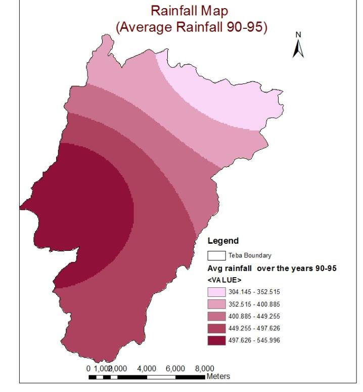
6 Graph 1 Map1 Map2 222

7 3.3 Agriculture Suitable Areas: Agriculture suitable areas delineated were presented as in Map 3. When compared to NDVI Map, agriculture suitable areas were observed only in those areas where NDVI increase was also seen (Map 1). Map 3 223
8 4. Conclusions Significant NDVI differences (decreasing trends) were observed from the year 91 to 94 through the multispectral satellite imageries. Temporal decreasing trends from the year were also seen in the rainfall data which is the main source of biomass. It was seen that decreasing trends of rainfall has directly affected the crop areas in the decreasing of biomass (NDVI). Suitable agriculture areas were delineated based upon available terrain and topographic characteristics. Most suitable areas were found to be those areas where NDVI had also increased which authenticates the People/farmers can focus on these areas while investing for agriculture for better yield This approach to satellite-image based change detection and delineation of suitable agricultural areas based upon terrain characteristics addresses several related challenges in areas with complex topography and geology. Acknowledgements The author is indebted to FACULTY FOR GEO-INFORMATION SCIENCE AND EARTH OBSERVATION (ITC), University of Twente, Hengelosestraat 99 P.O. Box 6, 7500 AA ENSCHEDE for carrying out this case study while in Three Months Training Course in Principles and Applications of Remote Sensing and GIS at ITC. Financial Support provided by NAIP, ICAR, New Delhi for this training is thankfully acknowledged. References Pradhan, S., 2002, Regional land cover mapping of the Hindu Kush Himalayan (HKH) Region: an approach to understand the dynamics of land use and land cover change using satellite image. GIS devleopment.net-application-natural Resource Management, Baban, S. M. J., and Luke, C., 2003, Mapping agricultural land use using retrospective ground referenced data, satellite sensor imagery and GIS. International Journal of Remote Sensing, 21, D. Lu, P Mausal, E. Brondizio and E. Moran, 2004, Change Detection Techniques. International Journal of Remote Sensing, 25, R.M. Bhagat. Sharda Singh. C. Sood. R.S. Rana. V. Kalia. S. Pradhan. W. Immerzeel. B. Shrestha, Land Suitability Analysis for Cereal Production in Himachal Pradesh (India) using Geographical Information System, J. Indian Soc. Remote Sens. (June 2009) 37:
Chitra Sood, R.M. Bhagat and Vaibhav Kalia Centre for Geo-informatics Research and Training, CSK HPKV, Palampur , HP, India
 APPLICATION OF SPACE TECHNOLOGY AND GIS FOR INVENTORYING, MONITORING & CONSERVATION OF MOUNTAIN BIODIVERSITY WITH SPECIAL REFERENCE TO MEDICINAL PLANTS Chitra Sood, R.M. Bhagat and Vaibhav Kalia Centre
Vegetation Change Detection of Central part of Nepal using Landsat TM
 Vegetation Change Detection of Central part of Nepal using Landsat TM Kalpana G. Bastakoti Department of Geography, University of Calgary, kalpanagb@gmail.com Abstract This paper presents a study of detecting
Landuse and Landcover change analysis in Selaiyur village, Tambaram taluk, Chennai
 Landuse and Landcover change analysis in Selaiyur village, Tambaram taluk, Chennai K. Ilayaraja Department of Civil Engineering BIST, Bharath University Selaiyur, Chennai 73 ABSTRACT The synoptic picture
Outline. Remote Sensing, GIS and DEM Applications for Flood Monitoring. Introduction. Satellites and their Sensors used for Flood Mapping
 Outline Remote Sensing, GIS and DEM Applications for Flood Monitoring Prof. D. Nagesh Kumar Chairman, Centre for Earth Sciences Professor, Dept. of Civil Engg. Indian Institute of Science Bangalore 560
Wastelands Analysis and Mapping of Bhiwani District, Haryana
 Wastelands Analysis and Mapping of Bhiwani District, Haryana Virender Sihag Research Scholar, Department of Geography, OPJS University, Churu, Rajasthan ABSTRACT This study aimed at monitoring, mapping,
Scientific registration n : 2180 Symposium n : 35 Presentation : poster MULDERS M.A.
 Scientific registration n : 2180 Symposium n : 35 Presentation : poster GIS and Remote sensing as tools to map soils in Zoundwéogo (Burkina Faso) SIG et télédétection, aides à la cartographie des sols
Investigation of Relationship Between Rainfall and Vegetation Index by Using NOAA/AVHRR Satellite Images
 World Applied Sciences Journal 14 (11): 1678-1682, 2011 ISSN 1818-4952 IDOSI Publications, 2011 Investigation of Relationship Between Rainfall and Vegetation Index by Using NOAA/AVHRR Satellite Images
DROUGHT ASSESSMENT USING SATELLITE DERIVED METEOROLOGICAL PARAMETERS AND NDVI IN POTOHAR REGION
 DROUGHT ASSESSMENT USING SATELLITE DERIVED METEOROLOGICAL PARAMETERS AND NDVI IN POTOHAR REGION Researcher: Saad-ul-Haque Supervisor: Dr. Badar Ghauri Department of RS & GISc Institute of Space Technology
Land Use/Land Cover Mapping in and around South Chennai Using Remote Sensing and GIS Techniques ABSTRACT
 Land Use/Land Cover Mapping in and around South Chennai Using Remote Sensing and GIS Techniques *K. Ilayaraja, Abhishek Singh, Dhiraj Jha, Kriezo Kiso, Amson Bharath institute of Science and Technology
SPECTRAL DISCRIMINATION OF ROCK TYPES IN THE ARAVALLI MOUNTAIN RANGES OF RAJASTHAN (INDIA) USING LANDSAT THEMATIC MAPPER DATA
 USING LANDSAT THEMATIC MAPPER DATA") SPECTRAL DISCRIMINATION OF ROCK TYPES IN THE ARAVALLI MOUNTAIN RANGES OF RAJASTHAN (INDIA) USING LANDSAT THEMATIC MAPPER DATA Dr. Nilanchal Patel Reader, Department of Remote Sensing Birla Institute of
SPECTRAL DISCRIMINATION OF ROCK TYPES IN THE ARAVALLI MOUNTAIN RANGES OF RAJASTHAN (INDIA) USING LANDSAT THEMATIC MAPPER DATA Dr. Nilanchal Patel Reader, Department of Remote Sensing Birla Institute of
Land Use and Land Cover Mapping and Change Detection in Jind District of Haryana Using Multi-Temporal Satellite Data
 Land Use and Land Cover Mapping and Change Detection in Jind District of Haryana Using Multi-Temporal Satellite Data Ravindra Prawasi, M.P. Sharma, T. P. Babu, Om Pal, Saroj, Kirti Yadav, R.S.Hooda Abstract
MONITORING OF SEASONAL SNOW COVER IN YAMUNA BASIN OF UTTARAKAHND HIMALAYA USING REMOTE SENSING TECHNIQUES
 MONITORING OF SEASONAL SNOW COVER IN YAMUNA BASIN OF UTTARAKAHND HIMALAYA USING REMOTE SENSING TECHNIQUES Anju Panwar, Devendra Singh Uttarakhand Space Application Centre, Dehradun, India ABSTRACT Himalaya
CHAPTER VII FULLY DISTRIBUTED RAINFALL-RUNOFF MODEL USING GIS
 80 CHAPTER VII FULLY DISTRIBUTED RAINFALL-RUNOFF MODEL USING GIS 7.1GENERAL This chapter is discussed in six parts. Introduction to Runoff estimation using fully Distributed model is discussed in first
MAPPING LAND USE/ LAND COVER OF WEST GODAVARI DISTRICT USING NDVI TECHNIQUES AND GIS Anusha. B 1, Sridhar. P 2
 MAPPING LAND USE/ LAND COVER OF WEST GODAVARI DISTRICT USING NDVI TECHNIQUES AND GIS Anusha. B 1, Sridhar. P 2 1 M. Tech. Student, Department of Geoinformatics, SVECW, Bhimavaram, A.P, India 2 Assistant
International Journal of Scientific & Engineering Research, Volume 6, Issue 7, July ISSN
 International Journal of Scientific & Engineering Research, Volume 6, Issue 7, July-2015 1428 Accuracy Assessment of Land Cover /Land Use Mapping Using Medium Resolution Satellite Imagery Paliwal M.C &.
CSK Himachal Pradesh Krishi Vishvavidyalaya
 CSK Himachal Pradesh Krishi Vishvavidyalaya (CSK HP Agricultural University) COLLEGE OF BASIC SCIENCES Palampur (H.P.) 176062, India Tel. 01894-230311(Off),230438(Resi) Fax: 01894-230311;Mob.9418193799
Geography Class XI Fundamentals of Physical Geography Section A Total Periods : 140 Total Marks : 70. Periods Topic Subject Matter Geographical Skills
 Geography Class XI Fundamentals of Physical Geography Section A Total Periods : 140 Total Marks : 70 Sr. No. 01 Periods Topic Subject Matter Geographical Skills Nature and Scope Definition, nature, i)
Application of Remote Sensing Techniques for Change Detection in Land Use/ Land Cover of Ratnagiri District, Maharashtra
 IOSR Journal of Applied Geology and Geophysics (IOSR-JAGG) e-issn: 2321 0990, p-issn: 2321 0982.Volume 3, Issue 6 Ver. II (Nov. - Dec. 2015), PP 55-60 www.iosrjournals.org Application of Remote Sensing
URBAN WATERSHED RUNOFF MODELING USING GEOSPATIAL TECHNIQUES
 URBAN WATERSHED RUNOFF MODELING USING GEOSPATIAL TECHNIQUES DST Sponsored Research Project (NRDMS Division) By Prof. M. GOPAL NAIK Professor & Chairman, Board of Studies Email: mgnaikc@gmail.com Department
This is trial version
 Journal of Rangeland Science, 2012, Vol. 2, No. 2 J. Barkhordari and T. Vardanian/ 459 Contents available at ISC and SID Journal homepage: www.rangeland.ir Full Paper Article: Using Post-Classification
Delineation of Groundwater Potential Zone on Brantas Groundwater Basin
 Delineation of Groundwater Potential Zone on Brantas Groundwater Basin Andi Rachman Putra 1, Ali Masduqi 2 1,2 Departement of Environmental Engineering, Sepuluh Nopember Institute of Technology, Indonesia
Influence of Micro-Climate Parameters on Natural Vegetation A Study on Orkhon and Selenge Basins, Mongolia, Using Landsat-TM and NOAA-AVHRR Data
 Cloud Publications International Journal of Advanced Remote Sensing and GIS 2013, Volume 2, Issue 1, pp. 160-172, Article ID Tech-102 ISSN 2320-0243 Research Article Open Access Influence of Micro-Climate
Abstract. TECHNOFAME- A Journal of Multidisciplinary Advance Research. Vol.2 No. 2, (2013) Received: Feb.2013; Accepted Oct.
 Received: Feb.2013; Accepted Oct.") Vol.2 No. 2, 83-87 (2013) Received: Feb.2013; Accepted Oct. 2013 Landuse Pattern Analysis Using Remote Sensing: A Case Study of Morar Block, of Gwalior District, M.P. Subhash Thakur 1 Akhilesh Singh 2
Vol.2 No. 2, 83-87 (2013) Received: Feb.2013; Accepted Oct. 2013 Landuse Pattern Analysis Using Remote Sensing: A Case Study of Morar Block, of Gwalior District, M.P. Subhash Thakur 1 Akhilesh Singh 2
International Journal of Advance Engineering and Research Development
 Scientific Journal of Impact Factor (SJIF): 4.72 International Journal of Advance Engineering and Research Development Volume 4, Issue 5, May -2017 Watershed Delineation of Purna River using Geographical
INTERNATIONAL JOURNAL OF ENVIRONMENTAL SCIENCES Volume 5, No 1, Copyright by the authors - Licensee IPA- Under Creative Commons license 3.
 INTERNATIONAL JOURNAL OF ENVIRONMENTAL SCIENCES Volume 5, No 1, 2014 Copyright by the authors - Licensee IPA- Under Creative Commons license 3.0 Research article ISSN 0976 4402 Manual and automated delineation
Use of Corona, Landsat TM, Spot 5 images to assess 40 years of land use/cover changes in Cavusbasi
 New Strategies for European Remote Sensing, Olui (ed.) 2005 Millpress, Rotterdam, ISBN 90 5966 003 X Use of Corona, Landsat TM, Spot 5 images to assess 40 years of land use/cover changes in Cavusbasi N.
LANDSLIDE SUSCEPTIBILITY MAPPING USING INFO VALUE METHOD BASED ON GIS
 LANDSLIDE SUSCEPTIBILITY MAPPING USING INFO VALUE METHOD BASED ON GIS ABSTRACT 1 Sonia Sharma, 2 Mitali Gupta and 3 Robin Mahajan 1,2,3 Assistant Professor, AP Goyal Shimla University Email: sonia23790@gmail.com
GROUNDWATER CONFIGURATION IN THE UPPER CATCHMENT OF MEGHADRIGEDDA RESERVOIR, VISAKHAPATNAM DISTRICT, ANDHRA PRADESH
 GROUNDWATER CONFIGURATION IN THE UPPER CATCHMENT OF MEGHADRIGEDDA RESERVOIR, VISAKHAPATNAM DISTRICT, ANDHRA PRADESH Prof.P.Jagadeesara Rao Department of Geo-Engineering and Centre for Remote Sensing, College
Preparation of LULC map from GE images for GIS based Urban Hydrological Modeling
 International Conference on Modeling Tools for Sustainable Water Resources Management Department of Civil Engineering, Indian Institute of Technology Hyderabad: 28-29 December 2014 Abstract Preparation
DROUGHT RISK EVALUATION USING REMOTE SENSING AND GIS : A CASE STUDY IN LOP BURI PROVINCE
 DROUGHT RISK EVALUATION USING REMOTE SENSING AND GIS : A CASE STUDY IN LOP BURI PROVINCE K. Prathumchai, Kiyoshi Honda, Kaew Nualchawee Asian Centre for Research on Remote Sensing STAR Program, Asian Institute
Fundamentals of Remote Sensing
 Division of Spatial Information Science Graduate School Life and Environment Sciences University of Tsukuba Fundamentals of Remote Sensing Prof. Dr. Yuji Murayama Surantha Dassanayake 10/6/2010 1 Fundamentals
Study of Land Use and Land Cover of Chaksu block, Jaipur through Remote Sensing and GIS
 Study of Land Use and Land Cover of Chaksu block, Jaipur through Remote Sensing and GIS Ruchi Middha *, Sonal Jain* and Shelja K.Juneja ** *RESEARCH SCHOLAR, ENVIRONMENTAL SCIENCE, THE IIS UNIVERSITY,
Digital Change Detection Using Remotely Sensed Data for Monitoring Green Space Destruction in Tabriz
 Int. J. Environ. Res. 1 (1): 35-41, Winter 2007 ISSN:1735-6865 Graduate Faculty of Environment University of Tehran Digital Change Detection Using Remotely Sensed Data for Monitoring Green Space Destruction
An experience with ILWIS in connection with National Geochemical Mapping by Geological Survey of India
 An experience with ILWIS in connection with National Geochemical Mapping by Geological Survey of India 1 S. Ramamurthy Geodata Division, Eastern Region, Geological Survey of India, Dk-6, Sector-2, Kolkata-91(ramasoma@yahoo.com)
Spanish national plan for land observation: new collaborative production system in Europe
 ADVANCE UNEDITED VERSION UNITED NATIONS E/CONF.103/5/Add.1 Economic and Social Affairs 9 July 2013 Tenth United Nations Regional Cartographic Conference for the Americas New York, 19-23, August 2013 Item
Plantations Mapping of Dabwali, Rania and Ellenabad blocks of Sirsa District Using on Screen Visual Interpretation Approach on WV-2 Data
 s Mapping of Dabwali, Rania and Ellenabad blocks of Sirsa District Using on Screen Visual Interpretation Approach on WV-2 Data Savita 1, Veena 2, Reetu Sharma 3 Haryana Space Applications Centre (HARSAC),
REVIEW MAPWORK EXAM QUESTIONS 31 JULY 2014
 REVIEW MAPWORK EXAM QUESTIONS 31 JULY 2014 Lesson Description In this lesson we: Focus on key concepts and exam questions relating to GIS. Question 1 Test Yourself The most important component of a GIS
Assessing Vulnerability to Soil Erosion of a Watershed of Tons River Basin in Madhya Pradesh using Remote Sensing and GIS
 International Journal of Environmental Research and Development. ISSN 2249-3131 Volume 4, Number 2 (2014), pp. 153-164 Research India Publications http://www.ripublication.com/ijerd.htm Assessing Vulnerability
Watershed Development Prioritization by Applying WERM Model and GIS Techniques in Takoli Watershed of District Tehri (Uttarakhand)
") Watershed Development Prioritization by Applying WERM Model and GIS Techniques in Takoli Watershed of District Tehri (Uttarakhand) Anju Panwar Uttarakhand Space Application Centre Dehradun, Uttarkhand
Watershed Development Prioritization by Applying WERM Model and GIS Techniques in Takoli Watershed of District Tehri (Uttarakhand) Anju Panwar Uttarakhand Space Application Centre Dehradun, Uttarkhand
GLOBAL/CONTINENTAL LAND COVER MAPPING AND MONITORING
 GLOBAL/CONTINENTAL LAND COVER MAPPING AND MONITORING Ryutaro Tateishi, Cheng Gang Wen, and Jong-Geol Park Center for Environmental Remote Sensing (CEReS), Chiba University 1-33 Yayoi-cho Inage-ku Chiba
Monitoring Vegetation Growth of Spectrally Landsat Satellite Imagery ETM+ 7 & TM 5 for Western Region of Iraq by Using Remote Sensing Techniques.
 Monitoring Vegetation Growth of Spectrally Landsat Satellite Imagery ETM+ 7 & TM 5 for Western Region of Iraq by Using Remote Sensing Techniques. Fouad K. Mashee, Ahmed A. Zaeen & Gheidaa S. Hadi Remote
Existing GIS Resources on the Indus Basin
 Existing GIS Resources on the Indus Basin Workshop on Spatial Information Analysis for the Sustainable Management of the Indus Basin in Pakistan May 26-27, 2003 Elements of Existing GIS Resources Data
Drought risk assessment using GIS and remote sensing: A case study of District Khushab, Pakistan
 15 th International Conference on Environmental Science and Technology Rhodes, Greece, 31 August to 2 September 2017 Drought risk assessment using GIS and remote sensing: A case study of District Khushab,
«Desertification and Drought Monitoring in Arid Tunisia based on Remote Sensing Imagery» Research Undertaken & Case-Studies.
 «Desertification and Drought Monitoring in Arid Tunisia based on Remote Sensing Imagery» Research Undertaken & Case-Studies EU COST Action September 2015, Antalya Turkey Bouajila ESSIFI INSTITUT DES REGIONS
investment decisions
 Climate modelling: A guide to investment decisions Vicky Pope Met Office Hadley Centre This is not an ADB material. The views expressed in this document are the views of the author/s and/or their organizations
Project title. Evaluation of MIR data from SPOT4/VEGETATION for the monitoring of climatic phenomena impact on vegetation
 Project title 1 Evaluation of MIR data from SPOT4/VEGETATION for the monitoring of climatic phenomena impact on vegetation Principal investigator: M-Christine IMBERTI Co-investigator: Frédéric BIARD Stockholm
Drought Estimation Maps by Means of Multidate Landsat Fused Images
 Remote Sensing for Science, Education, Rainer Reuter (Editor) and Natural and Cultural Heritage EARSeL, 2010 Drought Estimation Maps by Means of Multidate Landsat Fused Images Diego RENZA, Estíbaliz MARTINEZ,
VISUALIZATION URBAN SPATIAL GROWTH OF DESERT CITIES FROM SATELLITE IMAGERY: A PRELIMINARY STUDY
 CO-439 VISUALIZATION URBAN SPATIAL GROWTH OF DESERT CITIES FROM SATELLITE IMAGERY: A PRELIMINARY STUDY YANG X. Florida State University, TALLAHASSEE, FLORIDA, UNITED STATES ABSTRACT Desert cities, particularly
The Importance of Snowmelt Runoff Modeling for Sustainable Development and Disaster Prevention
 The Importance of Snowmelt Runoff Modeling for Sustainable Development and Disaster Prevention Muzafar Malikov Space Research Centre Academy of Sciences Republic of Uzbekistan Water H 2 O Gas - Water Vapor
Remote Sensing and GIS Applications for Hilly Watersheds SUBASHISA DUTTA DEPARTMENT OF CIVIL ENGINEERING IIT GUWAHATI
 Remote Sensing and GIS Applications for Hilly Watersheds SUBASHISA DUTTA DEPARTMENT OF CIVIL ENGINEERING IIT GUWAHATI Deciding Alternative Land Use Options in a Watershed Using GIS Source: Anita Prakash
Shalaby, A. & Gad, A.
 Urban Sprawl Impact Assessment on the Fertile Agricultural Land of Egypt Using Remote Sensing and Digital Soil Database, Case study: Qalubiya Governorate Shalaby, A. & Gad, A. National Authority for Remote
Review Using the Geographical Information System and Remote Sensing Techniques for Soil Erosion Assessment
 Polish J. of Environ. Stud. Vol. 19, No. 5 (2010), 881-886 Review Using the Geographical Information System and Remote Sensing Techniques for Soil Erosion Assessment Nuket Benzer* Landscape Architecture
International Journal of Intellectual Advancements and Research in Engineering Computations
 ISSN:2348-2079 Volume-5 Issue-2 International Journal of Intellectual Advancements and Research in Engineering Computations Agricultural land investigation and change detection in Coimbatore district by
A Method to Improve the Accuracy of Remote Sensing Data Classification by Exploiting the Multi-Scale Properties in the Scene
 Proceedings of the 8th International Symposium on Spatial Accuracy Assessment in Natural Resources and Environmental Sciences Shanghai, P. R. China, June 25-27, 2008, pp. 183-188 A Method to Improve the
International Journal of Scientific Research and Reviews
 Case Study Available online www.ijsrr.org ISSN: 2279 0543 International Journal of Scientific Research and Reviews Study on the Pattern of Land Use /Land Cover Change in Sonipat District of NCR, A Block
GEOGRAPHY (029) CLASS XI ( ) Part A: Fundamentals of Physical Geography. Map and Diagram 5. Part B India-Physical Environment 35 Marks
 CLASS XI ( ) Part A: Fundamentals of Physical Geography. Map and Diagram 5. Part B India-Physical Environment 35 Marks") GEOGRAPHY (029) CLASS XI (207-8) One Theory Paper 70 Marks 3 Hours Part A Fundamentals of Physical Geography 35 Marks Unit-: Geography as a discipline Unit-3: Landforms Unit-4: Climate Unit-5: Water (Oceans)
GEOGRAPHY (029) CLASS XI (207-8) One Theory Paper 70 Marks 3 Hours Part A Fundamentals of Physical Geography 35 Marks Unit-: Geography as a discipline Unit-3: Landforms Unit-4: Climate Unit-5: Water (Oceans)
Copyright is owned by the Author of the thesis. Permission is given for a copy to be downloaded by an individual for the purpose of research and
 Copyright is owned by the Author of the thesis. Permission is given for a copy to be downloaded by an individual for the purpose of research and private study only. The thesis may not be reproduced elsewhere
Fig. 1: Test area the Municipality of Mali Idjos, Cadastral Municipality Feketic
 Remote Sensing Application for Agricultural Land Value Classification Integrated in the Land Consolidation Survey Stojanka Brankovic, Ljiljana Parezanovic Republic Geodetic Authority, Belgrade, Serbia
A MODEL FOR RISES AND DOWNS OF THE GREATEST LAKE ON EARTH
 A MODEL FOR RISES AND DOWNS OF THE GREATEST LAKE ON EARTH Parviz Tarikhi Iranian Remote Sensing Center, Iran May 2005 1 Figure 1: West of Novshahr in the Iranian coast of Caspian; the dam constructed to
Civil Engineering Journal
 Available online at www.civilejournal.org Civil Engineering Journal Vol. 1, No. 2, December, 2015 Comparative Study of Landsat and Aster Data by Morphometric Analysis Sujit Kumar a*, Tapasi Bhandary b
Hendra Pachri, Yasuhiro Mitani, Hiro Ikemi, and Ryunosuke Nakanishi
 21 2nd International Conference on Geological and Civil Engineering IPCBEE vol. 8 (21) (21) IACSIT Press, Singapore DOI: 1.7763/IPCBEE. 21. V8. 2 Relationships between Morphology Aspect and Slope Failure
Monitoring Urban Space Expansion Using Remote Sensing Data in Ha Long City, Quang Ninh Province in Vietnam
 Monitoring Urban Space Expansion Using Remote Sensing Data in Ha Long City, Quang Ninh Province in Vietnam MY Vo Chi, LAN Pham Thi, SON Tong Si, Viet Key words: VSW index, urban expansion, supervised classification.
Landslide hazard assessment in the Khelvachauri area, Georgia
 Report on the project of AES Geohazards Stream Landslide hazard assessment in the Khelvachauri area, Georgia May 2010 George Jianping Panisara Gaprindashvili Guo Daorueang Institute of Geo-Information
KEY WORDS: Palmer Meteorological Drought Index, SWAP, Kriging spatial analysis and Digital Map.
 PALMER METEOROLOGICAL DROUGHT CLASSIFICATION USING TECHNIQUES OF GEOGRAPHIC INFORMATION SYSTEM IN THAILAND S. Baimoung, W. Waranuchit, S. Prakanrat, P. Amatayakul, N. Sukhanthamat, A. Yuthaphan, A. Pyomjamsri,
Monitoring and Temporal Study of Mining Area of Jodhpur City Using Remote Sensing and GIS
 Monitoring and Temporal Study of Mining Area of Jodhpur City Using Remote Sensing and GIS S. K Yadav 1, S. L Borana 2 1,2 Scientist, Remote Sensing Group, DL, Jodhpur-342011, Rajasthan, India ---------------------------------------------------------------------***---------------------------------------------------------------------
Droughts are normal recurring climatic phenomena that vary in space, time, and intensity. They may affect people and agriculture at local scales for
 I. INTRODUCTION 1.1. Background Droughts are normal recurring climatic phenomena that vary in space, time, and intensity. They may affect people and agriculture at local scales for short periods or cover
Dr. S.SURIYA. Assistant professor. Department of Civil Engineering. B. S. Abdur Rahman University. Chennai
 Hydrograph simulation for a rural watershed using SCS curve number and Geographic Information System Dr. S.SURIYA Assistant professor Department of Civil Engineering B. S. Abdur Rahman University Chennai
7.1 INTRODUCTION 7.2 OBJECTIVE
 7 LAND USE AND LAND COVER 7.1 INTRODUCTION The knowledge of land use and land cover is important for many planning and management activities as it is considered as an essential element for modeling and
CHAPTER-7 INTERFEROMETRIC ANALYSIS OF SPACEBORNE ENVISAT-ASAR DATA FOR VEGETATION CLASSIFICATION
 147 CHAPTER-7 INTERFEROMETRIC ANALYSIS OF SPACEBORNE ENVISAT-ASAR DATA FOR VEGETATION CLASSIFICATION 7.1 INTRODUCTION: Interferometric synthetic aperture radar (InSAR) is a rapidly evolving SAR remote
Abstract 1. The challenges facing Cartography in the new era.
 Geo-Informatic Tupu the New development of Cartography Qin Jianxin Ph. D. The Research Center of Geographic Information System (GIS), Hunan Normal University. Changsha, Hunan, 410081 E-Mail: qjxzxd@sina.com
CHAPTER 4 METHODOLOGY
 71 CHAPTER 4 METHODOLOGY 4.1 GENERAL Drought, a vague phenomenon, has been defined and analyzed in various ways. Drought assessment involves analysis of spatially and temporally varying water related data.
EFFECT OF ANCILLARY DATA ON THE PERFORMANCE OF LAND COVER CLASSIFICATION USING A NEURAL NETWORK MODEL. Duong Dang KHOI.
 EFFECT OF ANCILLARY DATA ON THE PERFORMANCE OF LAND COVER CLASSIFICATION USING A NEURAL NETWORK MODEL Duong Dang KHOI 1 10 Feb, 2011 Presentation contents 1. Introduction 2. Methods 3. Results 4. Discussion
Quantifying Land Use/Cover Dynamics of Nainital Town (India) Using Remote Sensing and GIS Techniques
 Using Remote Sensing and GIS Techniques") Quantifying Land Use/Cover Dynamics of Nainital Town (India) Using Remote Sensing and GIS Techniques Jiwan Rawat 1*, Vivekananda Biswas 1 and Manish Kumar 1 1 Centre of Excellence for NRDMS in Uttarakhand,
Quantifying Land Use/Cover Dynamics of Nainital Town (India) Using Remote Sensing and GIS Techniques Jiwan Rawat 1*, Vivekananda Biswas 1 and Manish Kumar 1 1 Centre of Excellence for NRDMS in Uttarakhand,
Abstract: About the Author:
 REMOTE SENSING AND GIS IN LAND USE PLANNING Sathees kumar P 1, Nisha Radhakrishnan 2 1 1 Ph.D Research Scholar, Department of Civil Engineering, National Institute of Technology, Tiruchirappalli- 620015,
Identifying Audit, Evidence Methodology and Audit Design Matrix (ADM)
") 11 Identifying Audit, Evidence Methodology and Audit Design Matrix (ADM) 27/10/2012 Exercise XXX 2 LEARNING OBJECTIVES At the end of this session participants will be able to: 1. Identify types and sources
11 Identifying Audit, Evidence Methodology and Audit Design Matrix (ADM) 27/10/2012 Exercise XXX 2 LEARNING OBJECTIVES At the end of this session participants will be able to: 1. Identify types and sources
DEM-based Ecological Rainfall-Runoff Modelling in. Mountainous Area of Hong Kong
 DEM-based Ecological Rainfall-Runoff Modelling in Mountainous Area of Hong Kong Qiming Zhou 1,2, Junyi Huang 1* 1 Department of Geography and Centre for Geo-computation Studies, Hong Kong Baptist University,
ABSTRACT. 2. Location : 31 o 04'16'' to 32 o 31'27'' North Latitudes and 74 o 30'38'' to 76 o 08'45'' East Longitudes
 ABSTRACT 1. Surveyed Area : Prioritization of Microwatersheds of Beas Catchment (1B1) of Districts-Amritsar, Firozpur, Gurdaspur, Hoshiarpur, Jalandhar, Kapurthala, Tarntaran, Punjab State and Districts-
1. Introduction. Chaithanya, V.V. 1, Binoy, B.V. 2, Vinod, T.R. 2. Publication Date: 8 April DOI: https://doi.org/ /cloud.ijarsg.
 Cloud Publications International Journal of Advanced Remote Sensing and GIS 2017, Volume 6, Issue 1, pp. 2088-2096 ISSN 2320 0243, Crossref: 10.23953/cloud.ijarsg.112 Research Article Open Access Estimation
ESTIMATING SNOWMELT CONTRIBUTION FROM THE GANGOTRI GLACIER CATCHMENT INTO THE BHAGIRATHI RIVER, INDIA ABSTRACT INTRODUCTION
 ESTIMATING SNOWMELT CONTRIBUTION FROM THE GANGOTRI GLACIER CATCHMENT INTO THE BHAGIRATHI RIVER, INDIA Rodney M. Chai 1, Leigh A. Stearns 2, C. J. van der Veen 1 ABSTRACT The Bhagirathi River emerges from
About the Author: Abstract:
 Temporal Analysis of Land use Pattern Changes of Noida, NCR Using Geospatial Tools Noyingbeni Kikon & Prafull Singh Amity Institute of Geo-informatics and Remote Sensing Amity University, Sector-125, Noida,
An Internet-based Agricultural Land Use Trends Visualization System (AgLuT)
") An Internet-based Agricultural Land Use Trends Visualization System (AgLuT) Prepared for Missouri Department of Natural Resources Missouri Department of Conservation 07-01-2000-12-31-2001 Submitted by
An Internet-based Agricultural Land Use Trends Visualization System (AgLuT) Prepared for Missouri Department of Natural Resources Missouri Department of Conservation 07-01-2000-12-31-2001 Submitted by
A GIS approach to generation of thematic maps to monitor tea plantations: A case study
 Two and a Bud 59(2):41-45, 2012 RESEARCH PAPER. A GIS approach to generation of thematic maps to monitor tea plantations: A case study Minerva Saiki a I and R.M. Bhagat Department of Soils, Tocklai Experimental
MODULE 8 LECTURE NOTES 2 REMOTE SENSING APPLICATIONS IN RAINFALL-RUNOFF MODELLING
 MODULE 8 LECTURE NOTES 2 REMOTE SENSING APPLICATIONS IN RAINFALL-RUNOFF MODELLING 1. Introduction The most common application of the remote sensing techniques in the rainfall-runoff studies is the estimation
Spatial Data Science. Soumya K Ghosh
 Workshop on Data Science and Machine Learning (DSML 17) ISI Kolkata, March 28-31, 2017 Spatial Data Science Soumya K Ghosh Professor Department of Computer Science and Engineering Indian Institute of Technology,
Geospatial Data Mining to Explore Watershed Development in Rainfed Regions
 Geospatial Data Mining to Explore Watershed Development in Rainfed Regions S. Nallan 1, L. Armstrong 1, Andreas Neuhaus 1,2, B. Croke 3, N. Dunstan 1,4 1 School of Computer and Security Science, Edith
A Basic Introduction to Geographic Information Systems (GIS) ~~~~~~~~~~
 ~~~~~~~~~~") A Basic Introduction to Geographic Information Systems (GIS) ~~~~~~~~~~ Rev. Ronald J. Wasowski, C.S.C. Associate Professor of Environmental Science University of Portland Portland, Oregon 3 September
A Basic Introduction to Geographic Information Systems (GIS) ~~~~~~~~~~ Rev. Ronald J. Wasowski, C.S.C. Associate Professor of Environmental Science University of Portland Portland, Oregon 3 September
Soil Erosion Calculation using Remote Sensing and GIS in Río Grande de Arecibo Watershed, Puerto Rico
 Soil Erosion Calculation using Remote Sensing and GIS in Río Grande de Arecibo Watershed, Puerto Rico Alejandra M. Rojas González Department of Civil Engineering University of Puerto Rico at Mayaguez.
EVALUATION AND MONITORING OF SNOWCOVER WATER RESOURCES IN CARPATHIAN BASINS USING GEOGRAPHIC INFORMATION AND SATELLITE DATA
 EVALUATION AND MONITORING OF SNOWCOVER WATER RESOURCES IN CARPATHIAN BASINS USING GEOGRAPHIC INFORMATION AND SATELLITE DATA Gheorghe Stancalie, Simona Catana, Anisoara Iordache National Institute of Meteorology
A NORMALIZED DIFFERENCE VEGETATION INDEX (NDVI) TIME-SERIES OF IDLE AGRICULTURE LANDS: A PRELIMINARY STUDY
 TIME-SERIES OF IDLE AGRICULTURE LANDS: A PRELIMINARY STUDY") A NORMALIZED DIFFERENCE VEGETATION INDEX (NDVI) TIME-SERIES OF IDLE AGRICULTURE LANDS: A PRELIMINARY STUDY Chaichoke Vaiphasa 1*, Supawee Piamduaytham 2, Tanasak Vaiphasa 3, and Andrew K. Skidmore 4 1
A NORMALIZED DIFFERENCE VEGETATION INDEX (NDVI) TIME-SERIES OF IDLE AGRICULTURE LANDS: A PRELIMINARY STUDY Chaichoke Vaiphasa 1*, Supawee Piamduaytham 2, Tanasak Vaiphasa 3, and Andrew K. Skidmore 4 1
Assessing Drought in Agricultural Area of central U.S. with the MODIS sensor
 Assessing Drought in Agricultural Area of central U.S. with the MODIS sensor Di Wu George Mason University Oct 17 th, 2012 Introduction: Drought is one of the major natural hazards which has devastating
23 in Watershed Management
 Module 6 (L22 L26): Use of Modern Techniques es in Watershed Management Applications of Geographical Information System and Remote Sensing in Watershed Management, Role of Decision Support System in Watershed
Lesson 4b Remote Sensing and geospatial analysis to integrate observations over larger scales
 Lesson 4b Remote Sensing and geospatial analysis to integrate observations over larger scales We have discussed static sensors, human-based (participatory) sensing, and mobile sensing Remote sensing: Satellite
Overview of Remote Sensing in Natural Resources Mapping
 Overview of Remote Sensing in Natural Resources Mapping What is remote sensing? Why remote sensing? Examples of remote sensing in natural resources mapping Class goals What is Remote Sensing A remote sensing
Site Suitability Analysis for Urban Development: A Review
 Site Suitability Analysis for Urban Development: A Review Santanu Kumar Misra Associate Professor (Dept. of CSE) Sikkim Manipal Institute of Technology Majitar, Sikkim misra_santanu@rediffmail.com Shrijana
Generation and analysis of Digital Elevation Model (DEM) using Worldview-2 stereo-pair images of Gurgaon district: A geospatial approach
 using Worldview-2 stereo-pair images of Gurgaon district: A geospatial approach") 186 Generation and analysis of Digital Elevation Model (DEM) using Worldview-2 stereo-pair images of Gurgaon district: A geospatial approach Arsad Khan 1, Sultan Singh 2 and Kaptan Singh 2 1 Department
186 Generation and analysis of Digital Elevation Model (DEM) using Worldview-2 stereo-pair images of Gurgaon district: A geospatial approach Arsad Khan 1, Sultan Singh 2 and Kaptan Singh 2 1 Department
Effect of land use/land cover changes on runoff in a river basin: a case study
 Water Resources Management VI 139 Effect of land use/land cover changes on runoff in a river basin: a case study J. Letha, B. Thulasidharan Nair & B. Amruth Chand College of Engineering, Trivandrum, Kerala,
PROANA A USEFUL SOFTWARE FOR TERRAIN ANALYSIS AND GEOENVIRONMENTAL APPLICATIONS STUDY CASE ON THE GEODYNAMIC EVOLUTION OF ARGOLIS PENINSULA, GREECE.
 PROANA A USEFUL SOFTWARE FOR TERRAIN ANALYSIS AND GEOENVIRONMENTAL APPLICATIONS STUDY CASE ON THE GEODYNAMIC EVOLUTION OF ARGOLIS PENINSULA, GREECE. Spyridoula Vassilopoulou * Institute of Cartography
GLL THE STUDY OF METHODS FOR CORRECTING GLOBAL DIGITAL TERRAIN MODELS USING REMOTE SENSING DATA. I. Kolb, M. Lucyshyn, M. Panek
 GLL http://dx.doi.org/10.15576/gll/2013.3.59 Geomatics, Landmanagement and Landscape No. 3 2013, 59 66 THE STUDY OF METHODS FOR CORRECTING GLOBAL DIGITAL TERRAIN MODELS USING REMOTE SENSING DATA Ihor Kolb,
Comparison of MLC and FCM Techniques with Satellite Imagery in A Part of Narmada River Basin of Madhya Pradesh, India
 Cloud Publications International Journal of Advanced Remote Sensing and GIS 013, Volume, Issue 1, pp. 130-137, Article ID Tech-96 ISS 30-043 Research Article Open Access Comparison of MLC and FCM Techniques
DEVELOPMENT OF DIGITAL CARTOGRAPHIC DATABASE FOR MANAGING THE ENVIRONMENT AND NATURAL RESOURCES IN THE REPUBLIC OF SERBIA
 DEVELOPMENT OF DIGITAL CARTOGRAPHIC BASE FOR MANAGING THE ENVIRONMENT AND NATURAL RESOURCES IN THE REPUBLIC OF SERBIA Dragutin Protic, Ivan Nestorov Institute for Geodesy, Faculty of Civil Engineering,