The Future of Soil Mapping using LiDAR Technology
|
|
|
- Justina Johnson
- 6 years ago
- Views:
Transcription
1 The Future of Soil Mapping using LiDAR Technology Jessica Philippe Soil Scientist/GIS Specialist March 24, 2016 Natural Resources Conservation Service Helping People Help the Land

2 Area 12-STJ covers parts of 5 states and dozens of traditional, non-mlra soil survey areas; about 17 million acres. Responsible for MLRA 143, Northeastern Mountains (excluding Adirondack region, NY).

3 12-STJ specialty: knowledge based raster soil mapping
4 Essential Soil Survey Procedures Delineate landforms and soil parent materials LiDAR signatures, terrain derivatives, imagery alongside extensive field reconnaissance Perform soil inference (ArcSIE) in suitable areas Lodgment till has a full catena model Ablation till and bedrock controlled areas have wet and dry components along with classic slope breaks Use other Digital Soil Mapping techniques as appropriate Slope stratification Possible traditional mapping in outwash and alluvial areas

5 Main uses of LiDAR in support of soil survey: A tool for landscape/landform/soil parent material visualization and stratification A source of terrain derivatives for soil predictive models
 courtesy of the US Geological")
6 Light Detection and Ranging System (LiDAR) courtesy of the US Geological Survey

7 LiDAR Point Cloud

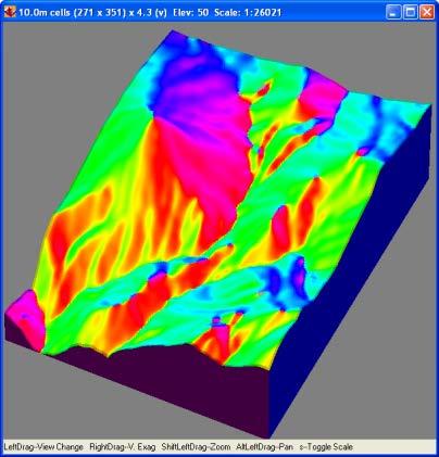
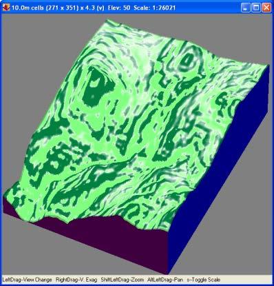
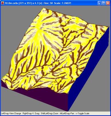
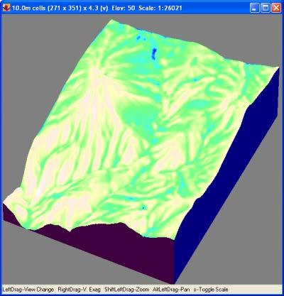
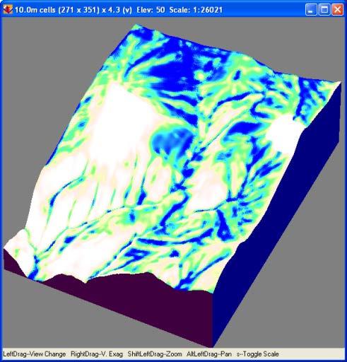
8 30-meter DEM 10-meter DEM 1-meter DEM Comparison of terrain models for Fresh Creek, Strafford County, NH: NED 30-meter and 10-meter DEMs versus 1-meter LiDAR
9 Essential Soil Survey Procedures Delineate landforms and soil parent materials LiDAR signatures, terrain derivatives, imagery alongside extensive field reconnaissance Perform soil inference (ArcSIE) in suitable areas Lodgment till has a full catena model Ablation till and bedrock controlled areas have wet and dry components along with classic slope breaks Use other Digital Soil Mapping techniques as appropriate Slope stratification Possible traditional mapping in outwash and alluvial areas


10 Visualization Prior to 2000 and the implementation of GIS in soil survey offices, landscape/landform visualization was via aerial photography and topographic maps.

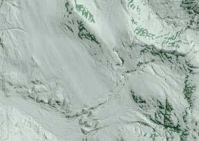
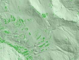
11 Now, bare-earth LiDAR elevation data, terrain derivatives, CIR (and other imagery), and GPS waypoints from reconnaissance are used for initial landscape stratification.

12 High Resolution Data (LiDAR) is Essential Hillshade from USGS 10m DEM With the implementation of GIS, spatial analysis techniques became more sophisticated. However, inadequate terrain data remains a limiting factor. Hillshade from 3m LiDAR DEM High-resolution elevation data from LiDAR overcomes this limitation.


13

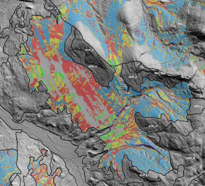
14 Parent material delineations are thoroughly critiqued and field checked. Field investigations are specifically directed.

15 Parent Material and Landform Maps Provide the Basis for all Subsequent Soil Mapping

16 Next step is to further stratify each type of parent material into appropriate soil classes. These classes could be as narrow as one soil component, but more realistically encompass multiple soil components/series that occur on similar landscape positions. The Arc Soil Inference Engine (ArcSIE) is used to model the typical soil formative environment for each class.


17 The soil classes that make up a given model generally encompass a catena. Poorly Drained Somewhat Poorly Drained Moderately Well Drained
18 Digital soil mapping (DSM) is a very broad concept. Knowledge-based Raster Soil Mapping is a specific approach to DSM
19 Raster Soil Mapping ArcSIE is a proven tool, designed for field soil scientists to implement knowledgebased raster soil mapping. We define the typical soil formative environment in the model, and the resulting fuzzy membership values represent the similarity of the soil at each pixel location to a particular soil series.
20 The focus in mapping shifts In conventional mapping, the primary question is Where is the boundary between two soils? and the focus is on those marginal areas. In fuzzy mapping, the primary question is Where is the typical soil for this type? and the focus is on those central areas.
21 Knowledge Represented as a Rule Elevation m is typical for soil A m 600m As elevation deviates from this range, the soil s similarity to type A gradually decreases. Similarity Elevation (m)


22 Soil Inference Components Soil Scientists Knowledge Soil Inference Engine Environmental Data Fuzzy Soil Membership Map

23 ArcSIE Interface Wetness index rule for poorly drained soils on moderate slopes

24 Raster Soil Mapping DEM An illustration of a basic raster soil mapping process that only uses terrain attributes. Cabot Terrain Attributes


25 Terrain Derivatives 30m slope Multi-path smoothed wetness index


26 Fuzzy membership maps are created for each soil class. We define the typical soil formative environment in the model, and the resulting fuzzy membership values represent the similarity of the soil at each pixel location to a particular soil class.
27 The fuzzy membership values represent the similarities of the pixel location to the typical soil formative environment. Typical Not Typical


28 Hardening (Defuzzification) Each pixel is assigned to the soil class with the highest fuzzy membership at that location.


29 SIE Results are Validated in the Field


30 Traditional ArcSIE Process Steps Inference by Soil Series Harden Results Integrate Slope Phases Create Logical Map Units


31 Predictive modeling by soil series Brute force modeling by landform and slope class Traditional mapping with modern enhancements --- All combined to create the SSURGO product


32 Inference by component

33 What is a raster component? Maybe better termed a soil class. Defined specifically by soil characteristics and position on the landform, such as: 11 nearly level to gently sloping wet soils on footslopes and in depressions 21 nearly level to gently sloping somewhat poorly drained soils on footslopes The model is designed to cover a catena of soils, and each modeled soil component/class is not limited in definition to a single soil series.

34 The catena models allows us to visualize where different components occur within a traditional map unit.

35 Essex County, VT is the first published raster soil survey in the country
, USFS Terrestrial Ecological Unit Inventory (TEUI), and NRCS Ecological Site Description (ESD) Right: draft soil parent")
36 Since 2010 the focus has been on joint (USFS, UNH, and NRCS) soil, site, and vegetation investigations in the 17,000 acre upper Wild Ammonoosuc River watershed in the White Mountain National Forest. This information is being used to develop models for soil survey (SSURGO), USFS Terrestrial Ecological Unit Inventory (TEUI), and NRCS Ecological Site Description (ESD) Right: draft soil parent materials in upper Wild Ammo watershed

 for the Northern Forest")
37 The St. Johnsbury Soil Survey Office is also supporting efforts to develop Ecological Site Descriptions (ESDs) for the Northern Forest Wildlife Refuges through a partnership with USFWS.


38 The St. Johnsbury Soil Survey Office is part of a team charged with mapping soils in the Boundary Waters Canoe Area Wilderness in Minnesota Knowledge-based modeling is being used in concert with logistic regression and random forests modeling to create the final raster soil map.

 implicitly represented by an existing soil")
39 Knowledge Discoverer (KD) is a module in ArcSIE for soil survey update. The approach is to discover, revise, and reuse the knowledge (soil-landscape model) implicitly represented by an existing soil map, during which it incorporates updated (better) knowledge and data.


 Soil")
40 Knowledge Discoverer Original SSURGO polygon of Dixfield sandy loam, 8-15 percent slope One typical curve was selected to represent each map unit, and edited according to new knowledge/better data (in this case LiDAR derivatives) Soil Inference Engine Updated map

41
42 Thank You! For more information, me:
Ecological Site Descriptions ESDs : NRCS Site-based Approach to Land Classification and Evaluation. Nels Barrett, NRCS Ecologist SSSSNE 20
 Ecological Site Descriptions ESDs : NRCS Site-based Approach to Land Classification and Evaluation Nels Barrett, NRCS Ecologist SSSSNE 20 Overview Definition of Ecological Sites, ES Content of Ecological
USING A KNOWLEDGE-BASED SYSTEM TO TEST THE TRANSFERABILITY OF A SOIL-LANDSCAPE MODEL IN NORTHEASTERN VERMONT
 USING A KNOWLEDGE-BASED SYSTEM TO TEST THE TRANSFERABILITY OF A SOIL-LANDSCAPE MODEL IN NORTHEASTERN VERMONT By JESSICA MCKAY A THESIS PRESENTED TO THE GRADUATE SCHOOL OF THE UNIVERSITY OF FLORIDA IN PARTIAL
Ongoing soil survey work: what and why, data revisions. The future of soil survey: new technologies
 Ongoing soil survey work: what and why, data revisions The future of soil survey: new technologies Jacob Isleib, Soil Scientist MLRA Soil Survey Office Tolland, CT USDA-NRCS Glaciated Soil Survey Region
Object Based Imagery Exploration with. Outline
 Object Based Imagery Exploration with Dan Craver Portland State University June 11, 2007 Outline Overview Getting Started Processing and Derivatives Object-oriented classification Literature review Demo
Terrain Attributes Aid Soil Mapping on Low-Relief Indiana
 Terrain Attributes Aid Soil Mapping on Low-Relief Indiana Landscapes Zamir Libohova 12 1,2 Edwin Winzeler 1 Phillip R. Owens 1 1 Agronomy, Purdue University, West Lafayette, IN 2 USDA/NRCS, Indianapolis,
ESRI GIS For Mining Seminar, 10 th August, 2016, Nairobi, Kenya. Spatial DATA Solutions for Mining
 ESRI GIS For Mining Seminar, 10 th August, 2016, Nairobi, Kenya Spatial DATA Solutions for Mining Spatial Data Solutions for Mining Spatial - Data that identifies the geographic location of features &
SoLIM: A new technology for soil survey
 SoLIM: A new technology for soil survey Soil Mapping Using GIS, Expert Knowledge & Fuzzy Logic September 25, 2002 Department of Geography, University of Wisconsin-Madison http://solim.geography.wisc.edu
Steve Pye LA /22/16 Final Report: Determining regional locations of reference sites based on slope and soil type. Client: Sonoma Land Trust
 Steve Pye LA 221 04/22/16 Final Report: Determining regional locations of reference sites based on slope and soil type. Client: Sonoma Land Trust Deliverables: Results and working model that determine
GIS APPLICATIONS IN SOIL SURVEY UPDATES
 GIS APPLICATIONS IN SOIL SURVEY UPDATES ABSTRACT Recent computer hardware and GIS software developments provide new methods that can be used to update existing digital soil surveys. Multi-perspective visualization
GIS Assessment and Modeling to Support Soil Landscape Correlation. Southern Regional Cooperative Soil Survey Conference July 17, 2008
 GIS Assessment and Modeling to Support Soil Landscape Correlation Southern Regional Cooperative Soil Survey Conference July 17, 2008 Sharon W. Waltman Soil Scientist-Spatial Data Analyst Amanda Moore Soil
Potential Restorable Wetlands (PRWs):
:") ASWM Webinar Sept. 17, 2014 Potential Restorable Wetlands (PRWs): Working definition: wetland hydrology and soils minus presently mapped wetlands for the re-establishment of wetlands Hydric Soil Query
ASWM Webinar Sept. 17, 2014 Potential Restorable Wetlands (PRWs): Working definition: wetland hydrology and soils minus presently mapped wetlands for the re-establishment of wetlands Hydric Soil Query
Remote Sensing and Geospatial Application for Wetlands Mapping, Assessment, and Mitigation
 Remote Sensing and Geospatial Application for Wetlands Mapping, Assessment, and Mitigation Hydrology Soils MSU Seminar Series Remote Sensing and Geospatial Applications September 4, 2002 Vegetation NEPA
Web Soil Survey National Cooperative Soil Survey
 122 14' 27'' W () 122 13' 37'' W 40 8' 40'' N 564700 564800 564900 565000 565100 565200 565300 565400 565500 565600 565700 565800 40 8' 40'' N 4443400 4443500 4443600 4443700 4443800 4443900 4444000 4443400
Spatial Survey of Surface Soil Moisture in a Sub-alpine Watershed
 Spatial Survey of Surface Soil Moisture in a Sub-alpine Watershed Katherine E. Williams M.S. GISc Candidate Department of Geography, University of Denver October 7, 2010 Purpose 2 Introduction to Soil
STM Development: A Systematic Approach Focused on Quality Control
 STM Development: A Systematic Approach Focused on Quality Control A Lofty Aspiration Tamzen K. Stringham University of Nevada, Reno Multiple Approaches Dig lots of holes - I will figure this out! Hang
Soil Map Boulder County Area, Colorado (Planet Blue Grass) Web Soil Survey National Cooperative Soil Survey
 Web Soil Survey National Cooperative Soil Survey") 475910 476000 476090 476180 476270 476360 105 16' 21'' W 476450 476540 476630 476720 476810 4453350 4453440 4453260 4453350 4453170 4453260 4453080 4453170 4453080 475820 475910 4452990 476000 476090 476180
475910 476000 476090 476180 476270 476360 105 16' 21'' W 476450 476540 476630 476720 476810 4453350 4453440 4453260 4453350 4453170 4453260 4453080 4453170 4453080 475820 475910 4452990 476000 476090 476180
Esri Image & Mapping Forum 9 July 2017 Geiger-Mode for Conservation Planning & Design by USDA NRCS NGCE
 Esri Image & Mapping Forum 9 July 2017 Geiger-Mode for Conservation Planning & Design by USDA NRCS NGCE For over 75 years, the Natural Resources Conservation Service has been a pioneer in conservation,
Summary Description Municipality of Anchorage. Anchorage Coastal Resource Atlas Project
 Summary Description Municipality of Anchorage Anchorage Coastal Resource Atlas Project By: Thede Tobish, MOA Planner; and Charlie Barnwell, MOA GIS Manager Introduction Local governments often struggle
Stephanie J. Connolly Forest Soil Scientist
 Stephanie J. Connolly Forest Soil Scientist Approximately 1 million acres High elevation Steep slopes Rain shadow effect Hydrologically shallow soils Sedimentary geology Acidic environments Biodiversity
Introduction. Elevation Data Strategy. Status and Next Steps
 1 2 Introduction Elevation Data Strategy Status and Next Steps 3 Canada is the 2nd largest country in the world - 9.9 million sq km Surrounded by 3 oceans with 202 000 km of coastline Population over 35
Data Quality and Uncertainty
 Data Quality and Uncertainty The power of GIS analysis is based on the assembly of layers of data, but as data layers increase, errors multiply - quality decreases. Garbage in, garbage out. High quality
12- TOL MLRA Soil Survey Area Approximately 15,000,000 Acres
 !@ 12- TOL MLRA Soil Survey Area Approximately 15,000,000 Acres Office Location: Tolland, Connecticut Staff: Donald Parizek Acting Soil Survey Office Party Leader Jacob Isleib Soil Scientist Marissa Theve
The 3D Elevation Program: Overview. Jason Stoker USGS National Geospatial Program ESRI 2015 UC
 + The 3D Elevation Program: Overview Jason Stoker USGS National Geospatial Program ESRI 2015 UC + 2 A little history USGS has a long, proud tradition of mapmaking (2009) + 3 The changing times Mapping
Ramani Geosystems. Putting Africa On The Map. Authorized Resellers
 Ramani Geosystems Putting Africa On The Map Authorized Resellers Ramani Profile Started in 1999 Aerial, Land Surveying & Mapping Solutions + 10 Countries in the region + 80 Staff working in projects Asset
Custom Soil Resource Report Soil Map
 121 3' 56'' W Custom Soil Resource Report Soil Map 121 2' 49'' W 45 16' 39'' N 5013800 5014000 5014200 5014400 5014600 5014800 5015000 5015200 5015400 5015600 651800 652000 652200 652400 652600 652800
Ecological Site Description Overview
 Ecological Site Description Overview 2018 Coastal Zone Soil Survey (CZSS) Work Planning Conference Savannah, GA January 9th, 2018 Greg Taylor Senior Regional Soil Scientist USDA-NRCS Raleigh, NC j.greg.taylor@nc.usda.gov
IMAGE AND DATA CREDITS
 Image credits All images created by Keranen and Image (figure 03_basics_a.tif) from ArcGIS Help 10.2 http://resources.arcgis.com/en/help /main/10.2/index.html#/015w0000006n000000, courtesy of Esri. Image
Mapping Your Land and Introduction to Web Soil Survey. Elizabeth Cook GIS Specialist USDA-NRCS (retired)
") Mapping Your Land and Introduction to Web Soil Survey Elizabeth Cook GIS Specialist USDA-NRCS (retired) Using Geographic Information Systems (GIS), Global Positioning System (GPS), digital aerial photography
Mapping Your Land and Introduction to Web Soil Survey Elizabeth Cook GIS Specialist USDA-NRCS (retired) Using Geographic Information Systems (GIS), Global Positioning System (GPS), digital aerial photography
Data Quality and Uncertainty. Accuracy, Precision, Data quality and Errors
 Data Quality and Uncertainty The power of GIS analysis is based on the assembly of layers of data, but as data layers increase, errors multiply (and quality decreases). Garbage in, garbage out. High quality
Spatial Survey of Surface Soil Moisture in a Sub-alpine Watershed Colloquium Presentation, University of Denver, Department of Geography
 Thank you all for coming today. I will be talking about my thesis work concerning the spatial distribution of soil moisture in an alpine catchment. But first we need some background in soil moisture. Why
Geospatial Data, Services, and Products. National Surveying, mapping and geospatial conference
 Geospatial Data, Services, and Products Federal Programs -- USDA NRCS National Surveying, mapping and geospatial conference March 15, 2016 NRCS Applications using Geosaptial Products & Services Field
RANCHO de DOS PALMAS DAVIS, California, AC +/-
 RANCHO de DOS PALMAS DAVIS, California, 507.28 AC +/- Boundary Transmission Line Pond / Tank Well SCOTT STONE P: (530) 662-4094 sastone57@gmail.com 37874 County Road 28, Woodland, Ca. 95695 The information
GEOMATICS. Shaping our world. A company of
 GEOMATICS Shaping our world A company of OUR EXPERTISE Geomatics Geomatics plays a mayor role in hydropower, land and water resources, urban development, transport & mobility, renewable energy, and infrastructure
GIS feature extraction tools in diverse landscapes
 CE 394K.3 GIS in Water Resources GIS feature extraction tools in diverse landscapes Final Project Anna G. Kladzyk M.S. Candidate, Expected 2015 Department of Environmental and Water Resources Engineering
GeoWEPP Tutorial Appendix
 GeoWEPP Tutorial Appendix Chris S. Renschler University at Buffalo - The State University of New York Department of Geography, 116 Wilkeson Quad Buffalo, New York 14261, USA Prepared for use at the WEPP/GeoWEPP
GIS Mapping for Hubbard Brook Experimental Forest A Service Learning Project for Plymouth Regional High School Environmental Science
 GIS Mapping for Hubbard Brook Experimental Forest A Service Learning Project for Plymouth Regional High School Environmental Science Hubbard Brook Experimental Forest [External Link], established in 1955
Web Soil Survey National Cooperative Soil Survey
 121 52' 18'' W Irrigated Capability Class Sutter County, California () 121 51' 49'' W 597600 597700 597800 597900 598000 598100 598200 39 6' 27'' N 39 6' 27'' N 39 5' 57'' N 4328400 4328500 4328600 4328700
MODELING RIPARIAN ZONES UTILIZING DEMS, FLOOD HEIGHT DATA, DIGITAL SOIL DATA AND NATIONAL WETLAND INVENTORY VIA GIS INTRODUCTION
 MODELING RIPARIAN ZONES UTILIZING DEMS, FLOOD HEIGHT DATA, DIGITAL SOIL DATA AND NATIONAL WETLAND INVENTORY VIA GIS Sinan Abood, PhD Candidate Ann Maclean, Professor School of Forest Resources and Environmental
THE ROLE OF GEOCOMPUTATION IN THE HYDROLOGICAL SCIENCES
 INTERNATIONAL SYMPOSIUM ON GEOCOMPUTATION AND ANALYSIS THE ROLE OF GEOCOMPUTATION IN THE HYDROLOGICAL SCIENCES JOHN P. WILSON UNIVERSITY OF SOUTHERN CALIFORNIA GIS RESEARCH LABORATORY Outline Background
ENGRG Introduction to GIS
 ENGRG 59910 Introduction to GIS Michael Piasecki March 17, 2014 Lecture 08: Terrain Analysis Outline: Terrain Analysis Earth Surface Representation Contour TIN Mass Points Digital Elevation Models Slope
Overview and Recent Developments
 SoLIM: An Effort Moving DSM into the Digital Era Overview and Recent Developments A-Xing Zhu 1,2 1 Department of Geography University of Wisconsin-Madison azhu@wisc.edu 2 Institute of Geographical Sciences
Prediction of Soil Properties Using Fuzzy Membership
 Prediction of Soil Properties Using Fuzzy Membership Zhu, A.X. 1,2 ; Moore, A. 3 ; Burt, J. E. 2 1 State Key Lab of Resources and Environmental Information System, Institute of Geographical Sciences and
Spatial Process VS. Non-spatial Process. Landscape Process
 Spatial Process VS. Non-spatial Process A process is non-spatial if it is NOT a function of spatial pattern = A process is spatial if it is a function of spatial pattern Landscape Process If there is no
Alaska, USA. Sam Robbins
 Using ArcGIS to determine erosion susceptibility within Denali National Park, Alaska, USA Sam Robbins Introduction Denali National Park is six million acres of wild land with only one road and one road
ENGRG Introduction to GIS
 ENGRG 59910 Introduction to GIS Michael Piasecki November 17, 2017 Lecture 11: Terrain Analysis Outline: Terrain Analysis Earth Surface Representation Contour TIN Mass Points Digital Elevation Models Slope
Eagle Creek Post Fire Erosion Hazard Analysis Using the WEPP Model. John Rogers & Lauren McKinney
 Eagle Creek Post Fire Erosion Hazard Analysis Using the WEPP Model John Rogers & Lauren McKinney Columbia River Gorge at Risk: Using LiDAR and GIS-based predictive modeling for regional-scale erosion susceptibility
Introduction to Geographic Information Systems (GIS): Environmental Science Focus
: Environmental Science Focus") Introduction to Geographic Information Systems (GIS): Environmental Science Focus September 9, 2013 We will begin at 9:10 AM. Login info: Username:!cnrguest Password: gocal_bears Instructor: Domain: CAMPUS
Introduction to Geographic Information Systems (GIS): Environmental Science Focus September 9, 2013 We will begin at 9:10 AM. Login info: Username:!cnrguest Password: gocal_bears Instructor: Domain: CAMPUS
Erin Costello A comparison of Solar Radiation Modeling Tools
 Erin Costello A comparison of Solar Radiation Modeling Tools The Oregon Department of Environmental Quality uses effective shade as an indicator of water quality parameters as well as a target for restoration
Quality and Coverage of Data Sources
 Quality and Coverage of Data Sources Objectives Selecting an appropriate source for each item of information to be stored in the GIS database is very important for GIS Data Capture. Selection of quality
What Do You See? FOR 274: Forest Measurements and Inventory. Area Determination: Frequency and Cover
 What Do You See? Message of the Day: Many options exist to determine the size, area, or extent of a feature on a landscape FOR 274: Forest Measurements and Inventory Lecture 7: Measures of Land Area Frequency
What s New in Topographic Information - USGS National Map
 + What s New in Topographic Information - USGS National Map SARGIS Workshop November 14, 2016 Rob Dollison, 703-648-5724 rdollison@usgs.gov + USGS 2 National Geospatial Program The National Geospatial
Review Using the Geographical Information System and Remote Sensing Techniques for Soil Erosion Assessment
 Polish J. of Environ. Stud. Vol. 19, No. 5 (2010), 881-886 Review Using the Geographical Information System and Remote Sensing Techniques for Soil Erosion Assessment Nuket Benzer* Landscape Architecture
Custom Soil Resource Report for Victoria County, Texas
 United States Department of Agriculture Natural Resources Conservation Service A product of the National Cooperative Soil Survey, a joint effort of the United States Department of Agriculture and other
Chapter 1 Overview of Maps
 Chapter 1 Overview of Maps In this chapter you will learn about: Key points when working with maps General types of maps Incident specific maps Map legend and symbols Map sources A map is a navigational
The National Hydrography Dataset in the Pacific Region. U.S. Department of the Interior U.S. Geological Survey
 The National Hydrography Dataset in the Pacific Region U.S. Department of the Interior U.S. Geological Survey The National Map The National Map is built on partnerships and standards The National Map consists
ECOLOGICAL MODELING FOR FOREST MANAGEMENT IN THE SHAWNEE NATIONAL FOREST
 ECOLOGICAL MODELING FOR FOREST MANAGEMENT IN THE SHAWNEE NATIONAL FOREST Richard G. Thurau, J.F. Fralish, S. Hupe, B. Fitch, and A.D. Carver 1 Abstract. Land managers of the Shawnee National Forest in
Management and Use of LiDAR-derived Information. Elizabeth Cook, GIS Specialist
 Management and Use of LiDAR-derived Information Elizabeth Cook, GIS Specialist Advanced LiDAR Workshop March 15, 2012 50-100 gb/county Now What? Project Deliverables LAS mass point files, classification
Scientific registration n : 2180 Symposium n : 35 Presentation : poster MULDERS M.A.
 Scientific registration n : 2180 Symposium n : 35 Presentation : poster GIS and Remote sensing as tools to map soils in Zoundwéogo (Burkina Faso) SIG et télédétection, aides à la cartographie des sols
Custom Soil Resource Report for Clackamas County Area, Oregon
 United States Department of Agriculture Natural Resources Conservation Service A product of the National Cooperative Soil Survey, a joint effort of the United States Department of Agriculture and other
Custom Soil Resource Report for Clackamas County Area, Oregon
 United States Department of Agriculture Natural Resources Conservation Service A product of the National Cooperative Soil Survey, a joint effort of the United States Department of Agriculture and other
Land Use MTRI Documenting Land Use and Land Cover Conditions Synthesis Report
 Colin Brooks, Rick Powell, Laura Bourgeau-Chavez, and Dr. Robert Shuchman Michigan Tech Research Institute (MTRI) Project Introduction Transportation projects require detailed environmental information
An Introduction to Geographic Information System
 An Introduction to Geographic Information System PROF. Dr. Yuji MURAYAMA Khun Kyaw Aung Hein 1 July 21,2010 GIS: A Formal Definition A system for capturing, storing, checking, Integrating, manipulating,
APPLICATION OF FUZZY SETS FUNCTION FOR LAND ATTRIBUTES MAPPING. Dwi Putro Tejo Baskoro ABSTRACT
 Application Jurnal Tanah of dan fuzzy Lingkungan, sets function Vol. (D.P.T. 10 No.1, Baskoro) April 2008:20-26 ISSN 1410-7333 APPLICATION OF FUZZY SETS FUNCTION FOR LAND ATTRIBUTES MAPPING Dwi Putro Tejo
USING GIS CARTOGRAPHIC MODELING TO ANALYSIS SPATIAL DISTRIBUTION OF LANDSLIDE SENSITIVE AREAS IN YANGMINGSHAN NATIONAL PARK, TAIWAN
 CO-145 USING GIS CARTOGRAPHIC MODELING TO ANALYSIS SPATIAL DISTRIBUTION OF LANDSLIDE SENSITIVE AREAS IN YANGMINGSHAN NATIONAL PARK, TAIWAN DING Y.C. Chinese Culture University., TAIPEI, TAIWAN, PROVINCE
The Evolution of NWI Mapping and How It Has Changed Since Inception
 The Evolution of NWI Mapping and How It Has Changed Since Inception Some Basic NWI Facts: Established in 1974 Goal to create database on characteristics and extent of U.S. wetlands Maps & Statistics In
Exhibit RMP-4. Foote Creek Geology and Topography
 Exhibit RMP-4 Foote Creek Geology and Topography Memorandum To: From: CC: Travis Brown, PacifiCorp Daria Drago, P.E., PMP Dr. Deb Luchsinger Date: January 9, 2019 Re: Foote Creek Rim 1 - Geologic Conditions
Web Soil Survey National Cooperative Soil Survey
 252500 252600 252700 252800 252900 253000 253100 83 47' 15'' W 83 47' 49'' W Nonirrigated Capability Class Jackson and Owsley Counties, Kentucky (Peggy Wilson Booneville Property - ) 253200 253300 37 25'
Use of Thematic Mapper Satellite Imagery, Hemispherical Canopy Photography, and Digital Stream Lines to Predict Stream Shading
 Use of Thematic Mapper Satellite Imagery, Hemispherical Canopy Photography, and Digital Stream Lines to Predict Stream Shading David Nagel GIS Analyst Charlie Luce Research Hydrologist Bárbara Gutiérrez
Project Leader: Project Partners:
 UTILIZING LIDAR TO MAP HIGH PRIORITY WOODLAND HABITAT IN ARKANSAS DEVELOPING METHODOLOGY AND CONDUCTING A PILOT PROJECT IN THE OZARK HIGHLANDS TO MAP CURRENT EXTENT, SIZE AND CONDITION Project Summary
Fugro Geospatial: Turning Spatial Data into Knowledge
 Fugro Geospatial: Turning Spatial Data into Knowledge 2016 Fugro Geospatial, GIS and Consultants Locations Variety of Collection Platforms Traditional Mapping Traditional Mapping Imagery Photogrammetric
Watershed concepts for community environmental planning
 Purpose and Objectives Watershed concepts for community environmental planning Dale Bruns, Wilkes University USDA Rural GIS Consortium May 2007 Provide background on basic concepts in watershed, stream,
MISSOURI LiDAR Stakeholders Meeting
 MISSOURI LiDAR Stakeholders Meeting East-West Gateway June 18, 2010 Tim Haithcoat Missouri GIO Enhanced Elevation Data What s different about it? Business requirements are changing.fast New data collection
USE OF RADIOMETRICS IN SOIL SURVEY
 USE OF RADIOMETRICS IN SOIL SURVEY Brian Tunstall 2003 Abstract The objectives and requirements with soil mapping are summarised. The capacities for different methods to address these objectives and requirements
Phase One Development of a Comprehensive GIS for the Mentor Marsh and its Proximal Watershed
 FINAL REPORT Phase One Development of a Comprehensive GIS for the Mentor Marsh and its Proximal Watershed Lake Erie Protection Fund SG 120-99 Ohio State University Research Foundation RF 738027 December
Classification of Erosion Susceptibility
 GEO327G: GIS & GPS Applications in Earth Sciences Classification of Erosion Susceptibility Denali National Park, Alaska Zehao Xue 12 3 2015 2 TABLE OF CONTENTS 1 Abstract... 3 2 Introduction... 3 2.1 Universal
Pierce Cedar Creek Institute GIS Development Final Report. Grand Valley State University
 Pierce Cedar Creek Institute GIS Development Final Report Grand Valley State University Major Goals of Project The two primary goals of the project were to provide Matt VanPortfliet, GVSU student, the
Wessinger Road, Hilton Area Chapin, South Carolina
 779' For Sale 191' 182' 171'! A! B 858' 4.84 ± Acres 788' 4.25 ± Acres 60' 241' 321' Wessinger Road, Hilton Area Chapin, South Carolina 357' 115' 51' 294'! C! D 6.51 ± Acres 902' 8.35 ± Acres 246' 60'
ELEVATION IS FOUNDATIONAL. A DEM that is inaccurate or of poor resolution will pass those characteristics onto other data layers
 ELEVATION IS FOUNDATIONAL A DEM that is inaccurate or of poor resolution will pass those characteristics onto other data layers THE DEM IS FOUNDATIONAL TO ALL GIS (Geospatial Information System) LAYERS
A Help Guide for Using gssurgo to Find Potential Wetland Soil Landscapes
 A Help Guide for Using gssurgo to Find Potential Wetland Soil Landscapes Wetland Mapping Consortium Webinar September 17, 2014 Dr. John M. Galbraith Crop & Soil Environmental Sciences Virginia Tech Wetland
Existing NWS Flash Flood Guidance
 Introduction The Flash Flood Potential Index (FFPI) incorporates physiographic characteristics of an individual drainage basin to determine its hydrologic response. In flash flood situations, the hydrologic
UPDATING THE MINNESOTA NATIONAL WETLAND INVENTORY
 UPDATING THE MINNESOTA NATIONAL WETLAND INVENTORY An Integrated Approach Using Object-Oriented Image Analysis, Human Air-Photo Interpretation and Machine Learning AARON SMITH EQUINOX ANALYTICS INC. FUNDING
CRUM RANCH AREA MAP YOLO COUNTY, California, AC +/-
 CRUM RANCH AREA MAP YOLO COUNTY, California, 235.59 AC +/- Map data 2016 Google Imagery 2016, CAPCOG, DigitalGlobe, Texas Orthoimagery Program, U.S. Geological Survey, USDA Farm Service Agency Boundary
Soil Surveys. What are the most important properties to consider in a taxonomic system used for making a soil survey?
 Soil Surveys What are the most important properties to consider in a taxonomic system used for making a soil survey? What is a Soil Survey? Inventory of soil resources Delineation of spatial distribution
Hydric Rating by Map Unit Harrison County, Mississippi. Web Soil Survey National Cooperative Soil Survey
 89 9' 7'' W 89 8' 38'' W 30 34' 13'' N 30 33' 57'' N 3383480 3383560 3383640 3383720 3383800 3383880 3383960 293640 293720 293800 293880 293960 294040 294120 294200 294280 294360 3383480 3383560 3383640
identify tile lines. The imagery used in tile lines identification should be processed in digital format.
 Question and Answers: Automated identification of tile drainage from remotely sensed data Bibi Naz, Srinivasulu Ale, Laura Bowling and Chris Johannsen Introduction: Subsurface drainage (popularly known
Outcrop suitability analysis of blueschists within the Dry Lakes region of the Condrey Mountain Window, North-central Klamaths, Northern California
 Outcrop suitability analysis of blueschists within the Dry Lakes region of the Condrey Mountain Window, North-central Klamaths, Northern California (1) Introduction: This project proposes to assess the
Cripps Ranch 76+/- Acres Orchard Development Opportunity Dixon, CA. Presented By:
 Cripps Ranch 76+/- Acres Orchard Development Opportunity Dixon, CA Presented By: Cripps Ranch 76+/- Acres Orchard Development Opportunity Dixon, CA Location: This property is located at 5663 Dally Road
Soil Map Polk County, Florida
 Soil Map Polk County, Florida 28 9' 21'' 28 8' 23'' 3113000 3113200 3113400 3113600 3113800 3114000 3114200 3114400 3114600 81 51' 19'' 81 51' 19'' 416000 416000 ± 416200 416200 68 416400 68 416400 7 13
Abstracts - Technical Presentations 1 st Joint LiDAR Workshop 29 June 2016
 Abstracts - Technical Presentations 1 st Joint LiDAR Workshop 29 June 2016 10:30 AM Title: The Finer details: Processing algorithm adjustment and point cloud/survey data statistics in wetlands. Authors:
Appendix 2b. NRCS Soil Survey
 Appendix 2b NRCS Soil Survey 118 19' 25'' W Nonirrigated Capability Class Antelope Valley Area, California (Del Sur Solar Site) 118 17' 28'' W 378900 379200 379500 379800 380100 380400 380700 381000 381300
Custom Soil Resource Report for Forrest County, Mississippi
 United States Department of Agriculture Natural Resources Conservation Service A product of the National Cooperative Soil Survey, a joint effort of the United States Department of Agriculture and other
Automatic Change Detection from Remote Sensing Stereo Image for Large Surface Coal Mining Area
 doi: 10.14355/fiee.2016.05.003 Automatic Change Detection from Remote Sensing Stereo Image for Large Surface Coal Mining Area Feifei Zhao 1, Nisha Bao 2, Baoying Ye 3, Sizhuo Wang 4, Xiaocui Liu 5, Jianyan
Crystal Moncada. California State University San Bernardino. January- July Brett R. Goforth- Department of Geography and Environmental Studies
 A Geographical Information System (GIS) Based Evaluation of Landslide Susceptibility Mapped on the Harrison Mountain Quadrangle of the Santa Ana River Watershed Crystal Moncada California State University
Urban Tree Canopy Assessment Purcellville, Virginia
 GLOBAL ECOSYSTEM CENTER www.systemecology.org Urban Tree Canopy Assessment Purcellville, Virginia Table of Contents 1. Project Background 2. Project Goal 3. Assessment Procedure 4. Economic Benefits 5.
GIS Changing the World GIS Day November 15, 2017
 + GIS Changing the World GIS Day November 15, 2017 + Growing Up On The Farm 3 Geographic Information in DNR A 75 year history of mapping and GIS. Forest type map from 1944. State of Washington - Division
Workshops funded by the Minnesota Environment and Natural Resources Trust Fund
 Workshops funded by the Minnesota Environment and Natural Resources Trust Fund Conservation Applications of LiDAR Data Workshops funded by: Minnesota Environment and Natural Resources Trust Fund Presented
Tracy Fuller U. S. Geological Survey. February 24, 2016
 U. S. Geological Survey Arctic Elevation Data Involvement Statewide Alaska IfSAR Radar Collection Program Pan-Arctic Digital Elevation Map International Coordination Tracy Fuller U. S. Geological Survey
Custom Soil Resource Report for Multnomah County Area, Oregon
 United States Department of Agriculture Natural Resources Conservation Service A product of the National Cooperative Soil Survey, a joint effort of the United States Department of Agriculture and other
Custom Soil Resource Report Soil Map
 77 35' 22'' W Custom Soil Resource Report Soil Map 77 35' 0'' W 282170 282220 282270 282320 282370 282420 282470 282520 282570 282620 40 59' 2'' N 40 58' 52'' N 4539900 4539950 4540000 4540050 4540100
Watershed Delineation in GIS Environment Rasheed Saleem Abed Lecturer, Remote Sensing Centre, University of Mosul, Iraq
 Watershed Delineation in GIS Environment Rasheed Saleem Abed Lecturer, Remote Sensing Centre, University of Mosul, Iraq Abstract: The management and protection of watershed areas is a major issue for human