GEOMATICS. Shaping our world. A company of
|
|
|
- Dwight Barber
- 5 years ago
- Views:
Transcription


1 GEOMATICS Shaping our world A company of


.")
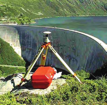
2 OUR EXPERTISE Geomatics Geomatics plays a mayor role in hydropower, land and water resources, urban development, transport & mobility, renewable energy, and infrastructure projects of all types. Geomatics is mainly concerned with the acquisition, analysis, processing, modelling and presentation of geospatial information. This is an essential requirement for solid economic development. Lahmeyer International s worldwide projects require a wide range of approaches to integrate different types of spatial information. Our experts of the Geomatics Department are professionals for advanced technologies in geospatial data acquisition and management. They have extensive experience both in developed and developing countries, working with a wide range of software and hardware products according to the type of project involved. We focus on land administration and cadaster, surveying and mapping, remote sensing and Geographical Information Systems (GIS). Land Administration and Cadastre In a world with growing economic and social challenges the relation between land ownership and a country s sustainable economic development increases in importance. Customised and future-oriented land development currently depends on the establishment of land information systems, where land titles, rights and other relevant land information, are registered together with their geographical reference data. Lahmeyer International has been involved in multiple land administration, cadastre, land use and land resources projects during the last decades. The main focus has been on the implementation of a coherent and complete cadastre and land register, including public awareness campaigns, training measures and strengthening of administrative capacity. Consulting for land register and cadastre systems Introduction of modern information technology infrastructure Implementation of standards, routines and procedures Management and procurement of equipment and services Cadastral surveys and pilot projects Customisation and training Dissemination of information for broad use Multipurpose cadastre Land use planning Land resources management Land valuation, taxation Political, legal and institutional framework Consideration of socio-economic impacts Quality management Training for local professionals


, orthophoto production and the generation of topographic and thematic maps.")
3 OUR PORTFOLIO Surveying and Mapping In all stages of project development, from preliminary studies to final implementation and operation control, extensive surveying tasks are essential for the success of the project. Our Geomatics Department consists of experts in engineering survey, geodetic and topographic survey, airborne survey, bathymetric survey, photogrammetry, and cartography. For more than five decades, Lahmeyer International has gained extensive experience in engineering surveying mainly for hydropower projects of varying size and in all phases of construction. Lahmeyer s experienced experts have conducted various geodetic and topographic surveys including bathymetric survey campaigns, which form the basis for a successful project development, implementation and monitoring. Lahmeyer International has over the last decades conducted various airborne data acquisition missions based on camera, laser and radar sensors. The services comprise the processing of digital terrain model and digital surface models (DTM/ DSM), orthophoto production and the generation of topographic and thematic maps. The use of unmaned aerial vehicles (UAV), or drones, in the field of surveying has increased significantly in the last years. In certain applications UAVs have many advantages compared to conventional airborne and terrestrial surveys. Lahmeyer International offers these services for project development, in particular, aerial videos and photographs of remote project areas, fast and reliable topographic survey data, and post processed DSM, DTM and orthophoto imagery. Implementation of large scale geodetic networks Precise project control networks Geodetic deformation measurements Design and implementation of monitoring systems Management of quantity surveys Underground surveys Construction surveys Bathymetric surveys Airborne data acquisition (camera, laser, radar) UAV surveys, drone surveys Terrestrial and airborne mapping at small and large scales Topographic mapping Orthophoto mapping 3-D modelling Training of local professionals Drone on mission Orthophoto map Bathymetric survey


4 OUR PORTFOLIO Remote Sensing Remote sensing technology plays a fundamental role for primary data collection. Satellite platforms are increasing tremendously and offer a large variety of earth observation data with different ground resolutions, swath width and spectral parameters. We frequently use remote sensing data and image analyses techniques which is an economic solution for up-to-date information and long-term monitoring surveillance at different scales and for various applications. Whether for topographic or thematic mapping, land use planning, forest inventories, environmental monitoring or disaster management, we customise our approach according to the project requirements. Adapted to the client s project requirements computer-aided visual interpretation, automatic classifications or knowledge based techniques are used. Our remote sensing and GIS experts organise and execute several different remote sensing projects. These include data acquisition and capture, field surveys and ground truthing through all phases of image processing and analyses, the extraction and presentation of information in geographic information systems and professional maps. Accuracy assessment, quality control, training and information dissemination through internet and other media are further services that we provide. Acquisition and analysis of various remote sensing data (satellite data, aerial photography. LIDAR, UAV etc.) Ground Control Point (GCP) surveys and ground truthing Provision and update of topographic information at different scales Map production Natural resources management Urban and rural mapping Soil and geological surveys Forest inventories Applications for agriculture, irrigation and hydrology Land cover and land use inventories Image classification and change detection Topographic and thematic cartography at different scales Modelling simulations Training of local professionals Multispectral imagery Landuse analysis Hillshaded digital terrain model High resolution orthophoto


5 OUR PORTFOLIO Geographic Information Systems Engineering services for studies, tender preparation and construction projects strongly rely on the availability of accurate spatial information about the projects and the terrain on which they are being built. Geospatial and analytic products processed and made available by a Geographic Information Systems (GIS) allow for more effective planning, construction, and maintenance of engineering and construction projects. Geographic Information Systems are an effective tool for integrated geographic analyses of vector and raster data, professional map production and long-term data management, modelling and monitoring. The spatial analytical capabilities of GIS are used for a variety of applications. Applications Land suitability analysis Site selection Distance and proximity calculations Multi-criteria analysis Digital Elevation Model (DEM) processing and modelling Volume calculations River basin modelling Flood control and water management Hydrological and hydraulic modelling Hydropower project analyses and evaluation Environmental mapping and monitoring Environmental impact studies Erosion analysis Natural hazard risk management Damage documentation and assessment Disaster management solutions Consulting for GIS solutions Development of document and spatial data management systems Set-up of complex land information systems and software applications Set-up of web-based geodata portals using open-source solutions Web-based data management Application building and customising Training of local professionals Environmental analysis Typical GIS-layer
6 OUR COMPANY w Lahmeyer A Company of Tractebel At the helm of the Energy Transition, Tractebel provides a full range of engineering and consulting services throughout the life cycle of its clients projects, including design and project management. As one of the world s largest engineering consultancy companies and with more than 150 years of experience, it s our mission to actively shape the world of tomorrow. With about 4,500 experts and offices in 33 countries, we are able to offer our customers multidisciplinary solutions in energy, water and infrastructure. Since December 2014, Lahmeyer belongs to Tractebel and thus is part of the international ENGIE group headquartered in Paris. Tractebel, which is based in Brussels, and Lahmeyer, which is based in Bad Vilbel near Frankfurt, cooperate on numerous international projects and keep growing closer as one company. Lahmeyer International GmbH Friedberger Str Bad Vilbel, Germany Phone: Fax: info@de.lahmeyer.com blog-tractebel.lahmeyer.de 2,800 1,000 4,500 employees 150 years of experience 33 offices worldwide > 10 projects projects projects projects > 1000 projects Offices Lahmeyer International 07/18
Land Administration and Cadastre
 Geomatics play a major role in hydropower, land and water resources and other infrastructure projects. Lahmeyer International s (LI) worldwide projects require a wide range of approaches to the integration
State of Israel Ministry of Housing and Construction Survey of Israel. The Hydrological project case
 State of Israel Ministry of Housing and Construction Survey of Israel The Hydrological project case Survey of Israel Content Introduction To the Survey of Israel The operation assumptions The main responsibilities
SUSTAINABLE SEDIMENT MANAGEMENT
 SUSTAINABLE SEDIMENT MANAGEMENT Shaping our world A company of OUR EXPERTISE Sediments can make or break a Project Numerous examples of dams and reservoirs can be found throughout the world whose live
Building a National Data Repository
 Building a National Data Repository Mladen Stojic, Vice President - Geospatial 1/30/2013 2012 Intergraph Corporation 1 Information has meaning and gives power only when shared and distributed. Information,
THE USE OF GEOMATICS IN CULTURAL HERITAGE AND ARCHAEOLOGY FOR VARIOUS PURPOSES
 THE USE OF GEOMATICS IN CULTURAL HERITAGE AND ARCHAEOLOGY FOR VARIOUS PURPOSES FEBRUARY 2013 AL BEIDA GEOPLAN CONTENT Company Profile Concept Objectives and Strategies Data Production Methods Data Samples
Sustainable and Harmonised Development for Smart Cities The Role of Geospatial Reference Data. Peter Creuzer
 Sustainable and Harmonised Development for Smart Cities The Role of Geospatial Reference Data Peter Creuzer 1. Introduction - Smart Cities and Geodata 2. Geodata in Germany 3. Examples 4. Data and Service
GIS and Remote Sensing
 Spring School Land use and the vulnerability of socio-ecosystems to climate change: remote sensing and modelling techniques GIS and Remote Sensing Katerina Tzavella Project Researcher PhD candidate Technology
Ramani Geosystems. Putting Africa On The Map. Authorized Resellers
 Ramani Geosystems Putting Africa On The Map Authorized Resellers Ramani Profile Started in 1999 Aerial, Land Surveying & Mapping Solutions + 10 Countries in the region + 80 Staff working in projects Asset
Spanish national plan for land observation: new collaborative production system in Europe
 ADVANCE UNEDITED VERSION UNITED NATIONS E/CONF.103/5/Add.1 Economic and Social Affairs 9 July 2013 Tenth United Nations Regional Cartographic Conference for the Americas New York, 19-23, August 2013 Item
Georeferencing and Satellite Image Support: Lessons learned, Challenges and Opportunities
 Georeferencing and Satellite Image Support: Lessons learned, Challenges and Opportunities Shirish Ravan shirish.ravan@unoosa.org UN-SPIDER United Nations Office for Outer Space Affairs (UNOOSA) UN-SPIDER
Global UAV-based solutions for the industry and agriculture.
 Global UAV-based solutions for the industry and agriculture. Remote sensing of vegetation from drones (UAS). The example of the Trimble Unmanned Aerial Solution Emmanuel de Maistre, co-founder & CEO demaistre@redbird.fr
Imagery and the Location-enabled Platform in State and Local Government
 Imagery and the Location-enabled Platform in State and Local Government Fred Limp, Director, CAST Jim Farley, Vice President, Leica Geosystems Oracle Spatial Users Group Denver, March 10, 2005 TM TM Discussion
CARTOGRAPHIC INFORMATION MANAGEMENT IN COLOMBIA REACH A LEVEL OF PERFECTION
 CARTOGRAPHIC INFORMATION MANAGEMENT IN COLOMBIA REACH A LEVEL OF PERFECTION Jaime Alberto Duarte Castro 1 Carrera 30 No. 48 51 Bogotá - Colombia, jduarte@igac.gov.co Claudia Inés Sepúlveda Fajardo 2 Carrera
VISUALIZING THE SMART CITY 3D SPATIAL INFRASTRUCTURE GEOSMART ASIA- 30 SEP, 2015
 www.aamgroup.com VISUALIZING THE SMART CITY 3D SPATIAL INFRASTRUCTURE GEOSMART ASIA- 30 SEP, 2015 Agenda AAM What is a Smart City? Data Acquisition 3D Modelling Benefits Questions AAM AAM is a Geospatial
Excel Geomatics: Offering Excellence with Unique Consultancy & Services
 Excel Geomatics: Offering Excellence with Unique Consultancy & Services Providing consultancy and value Added Services using Remote Sensing, Photogrammetry and LiDAR in areas such as Agriculture, Forestry,
Airborne Corridor-Mapping. Planning and documentation of company infrastructure: precise, rapid, and cost effective
 Airborne Corridor-Mapping Planning and documentation of company infrastructure: precise, rapid, and cost effective Technology Airborne Laser-Scanning, digital orthophotos and thermal imaging: one flight
Yrd. Doç. Dr. Saygın ABDİKAN Öğretim Yılı Güz Dönemi
 Yabancı Dil III (YDL285) Introduction to Geomatics Yrd. Doç. Dr. Saygın ABDİKAN 2017-2018 Öğretim Yılı Güz Dönemi 1 géomatique Geo (Earth) + informatics Geodesy + Geoinformatics Geomatics: The mathematics
To achieve these Global Sustainable Development Goals, geospatial data are crucial.
 To achieve these Global Sustainable Development Goals, geospatial data are crucial. 2 http://www.globalgoals.org/ HIGH INCOME NATION SUSTAINABLE GROWTH SOCIALLY INCLUSIVE 3 http://etp.pemandu.gov.my/ 12
Geotechnical Engineering and Dams
 Geotechnical Engineering and Dams Solving Geotechnical Challenges for Hydropower and Water Resources Projects Geological and geotechnical challenges are often very demanding when planning hydraulic structures.
Exploring the boundaries of your built and natural world. Geomatics
 Exploring the boundaries of your built and natural world Geomatics Before the Luxor brought magic to the Las Vegas strip and before the South LRT extension in Edmonton gave residents a new route to travel,
QUESTIONNAIRE THE CURRENT STATUS OF MAPPING IN THE WORLD
 QUESTIONNAIRE ON THE CURRENT STATUS OF MAPPING IN THE WORLD The questionnaire is intended to take stock of the current status of mapping in the world. The information collected will eventually be used
Statewide Topographic Mapping Program
 Statewide Topographic Mapping Program February 28, 2018 www.dotd.la.gov Outline Purpose of the Statewide Topographic Mapping Program History Breakdown of R.S. 48:36 - Topographic Mapping Statewide Topographic
Cutting Edge Engineering for Modern Geospatial Systems Rear Admiral Dr. S Kulshrestha, retd
 Cutting Edge Engineering for Modern Geospatial Systems Rear Admiral Dr. S Kulshrestha, retd 11 Jun 2015 GeoIntelligence Asia 2015 The technology would become so pervasive that it becomes a part of you
Case Study microdrones in Geomatics Remote Sensing
 Case Study microdrones in Geomatics Remote Sensing Version 1.0 Presented by: Carlos Espadas (INGECOR Geomática SL) & Michael Thoss (microdrones GmbH) Profiles: microdrones / Ingecor Geomática Contact information
Country Report of Spain *
 Committee of Experts on Global Geospatial Information Management Second Session New York, United Nations (UN), 13 15 de August de 2012 Country Report of Spain * * Submitted by: Mr. Antonio Arozarena, Deputy
Themes for Geomatics Conference. Geodesy Themes
 Themes for Geomatics Conference Geodesy Themes Geodynamics o Modeling the Deformation of the Earth s Crust o Recent Advances in Geometric Approaches to Deformation Analysis o Monitoring Systems (Sensors
CLICK HERE TO KNOW MORE
 CLICK HERE TO KNOW MORE GENERALIZATION OF TOPOGRAPHIC DATABASE FOR SERVING GEOSPATIAL DATA FOR MILITARY AND SOCIO-ECONOMIC TASKS IN VIETNAM Speaker: Lieutenant Colonel, Nguyen Dinh Minh GENERAL STAFF -
NSDI Policy Framework of Japan - Roles of the Private Sector in SDI -
 NSDI Policy Framework of Japan - Roles of the Private Sector in SDI - Hiroshi Murakami (GSI) Geospatial World Forum 2012 Amsterdam Background Survey Act (1949) mandates the (GSI) to develop and provide
Technical Drafting, Geographic Information Systems and Computer- Based Cartography
 Technical Drafting, Geographic Information Systems and Computer- Based Cartography Project-Specific and Regional Resource Mapping Services Geographic Information Systems - Spatial Analysis Terrestrial
Data Origin. Ron van Lammeren CGI-GIRS 0910
 Data Origin Ron van Lammeren CGI-GIRS 0910 How to obtain geodata? Geo data initiative Executive Order 12906, "Coordinating Geographic Data Acquisition and Access: The National Spatial Data Infrastructure,"
Disaster Management in Mongolia
 The Third UN-GGIM-AP Plenary Meeting Disaster Management in Mongolia ~Coordination among NGIA & Other Related Organizations and Recommendations~ Bali Indonesia 10 November 2014 Khurelshagai Ayurzana, Director
Geo-hazard Potential Mapping Using GIS and Artificial Intelligence
 Geo-hazard Potential Mapping Using GIS and Artificial Intelligence Theoretical Background and Uses Case from Namibia Andreas Knobloch 1, Dr Andreas Barth 1, Ellen Dickmayer 1, Israel Hasheela 2, Andreas
European Spatial Data Research. EuroSDR. Prof. Dr. Ir. Joep Crompvoets. General Assembly CLGE Tirana 18 March
 EuroSDR Prof. Dr. Ir. Joep Crompvoets General Assembly CLGE - 2016 Tirana 18 March 2016 INTRODUCTORY QUESTIONS Who knows what is EuroSDR? Who does NOT know what is EuroSDR? Who is employed at mapping agencies?
MALDIVES. Regional Expert Workshop On Land Accounting For SDG Monitoring & Reporting (25-27 th Sept 2017) - Fathimath Shanna, Aishath Aniya -
 - Fathimath Shanna, Aishath Aniya -") MALDIVES Regional Expert Workshop On Land Accounting For SDG Monitoring & Reporting (25-27 th Sept 2017) - Fathimath Shanna, Aishath Aniya - ABOUT MALDIVES Approximately 860 km long and 120 km wide Consists
MALDIVES Regional Expert Workshop On Land Accounting For SDG Monitoring & Reporting (25-27 th Sept 2017) - Fathimath Shanna, Aishath Aniya - ABOUT MALDIVES Approximately 860 km long and 120 km wide Consists
GIS = Geographic Information Systems;
 What is GIS GIS = Geographic Information Systems; What Information are we talking about? Information about anything that has a place (e.g. locations of features, address of people) on Earth s surface,
Roles of NGII in successful disaster management
 The Second UN-GGIM-AP Plenary Meeting Roles of NGII in successful disaster management Republic of Korea Teheran Iran 28 October 2013 Sanghoon Lee, Ph.D. NGII Outline Type of Disasters Occur in Korea Practical
Adding value to Copernicus services with member states reference data
 www.eurogeographics.org Adding value to Copernicus services with member states reference data Neil Sutherland neil.sutherland@os.uk GIS in the EU 10 November 2016 Copyright 2016 EuroGeographics 61 member
CENSUS MAPPING WITH GIS IN NAMIBIA. BY Mrs. Ottilie Mwazi Central Bureau of Statistics Tel: October 2007
 CENSUS MAPPING WITH GIS IN NAMIBIA BY Mrs. Ottilie Mwazi Central Bureau of Statistics E-mail: omwazi@npc.gov.na Tel: + 264 61 283 4060 October 2007 Content of Presentation HISTORICAL BACKGROUND OF CENSUS
Part : General Situation of Surveying and Mapping. The Development of Surveying and Mapping in China. The contents
 The Development of Surveying and Mapping in China Dr. Ping Xiao China.P.R The contents Part : General Situation of Surveying and Mapping 1. The legal systems of surveying and mapping 2. The technologies
Disaster Management in Republic of Korea
 The Third UN-GGIM-AP Plenary Meeting Disaster Management in Republic of Korea ~Coordination among NGIA & Other Related Organizations and Recommendations~ Bali Indonesia 10 November 2014 Sanghoon Lee, Ph.D.
Syllabus Reminders. Geographic Information Systems. Components of GIS. Lecture 1 Outline. Lecture 1 Introduction to Geographic Information Systems
 Syllabus Reminders Geographic Information s Lecture Introduction to Geographic Information s. Class Info: www.saigis.com/class/ 2. Office T / TH (8:00-9:30 a.m.) and (2:30 3:30pm) or Appt 3. Email: burgerpr@unk.edu
SDI Development in Georgia. Mari Khardziani Head of International Relations Unit National Agency of Public Registry
 SDI Development in Georgia Mari Khardziani Head of International Relations Unit National Agency of Public Registry Kehl, Germany September 5, 2017 2 National Agency of Public Registry Legal Entity of Public
Land Use / Land Cover Mapping in
 Land Use / Land Cover Mapping in Eastern and Southern African Regions RCMRD Experience by 6/24/2013, Nairobi Kenya Dr. Tesfaye Korme Director of RS, GIS and Mapping, RCMRD I. About RCMRD, Its Vision and
UNITED NATIONS E/CONF.96/CRP. 5
 UNITED NATIONS E/CONF.96/CRP. 5 ECONOMIC AND SOCIAL COUNCIL Eighth United Nations Regional Cartographic Conference for the Americas New York, 27 June -1 July 2005 Item 5 of the provisional agenda* COUNTRY
Unmanned Aerial Systems (UAS) Innovation for affordable, improved and accelerated spatial data acquisition
 Innovation for affordable, improved and accelerated spatial data acquisition") Unmanned Aerial Systems (UAS) Innovation for affordable, improved and accelerated spatial data acquisition Kathrine Kelm, The World Bank Rumyana Tonchovska, FAO Walter Volkmann, Micro Aerial Projects,
Unmanned Aerial Systems (UAS) Innovation for affordable, improved and accelerated spatial data acquisition Kathrine Kelm, The World Bank Rumyana Tonchovska, FAO Walter Volkmann, Micro Aerial Projects,
Manitoba s Elevation (LiDAR) & Imagery Datasets. Acquisition Plans & Opportunities for Collaboration
 & Imagery Datasets. Acquisition Plans & Opportunities for Collaboration") Manitoba s Elevation (LiDAR) & Imagery Datasets Acquisition Plans & Opportunities for Collaboration Manitoba Planning Conference May 2017 Presentation Outline Manitoba s Elevation (LiDAR) and Imagery Datasets
Manitoba s Elevation (LiDAR) & Imagery Datasets Acquisition Plans & Opportunities for Collaboration Manitoba Planning Conference May 2017 Presentation Outline Manitoba s Elevation (LiDAR) and Imagery Datasets
Disaster Management & Recovery Framework: The Surveyors Response
 Disaster Management & Recovery Framework: The Surveyors Response Greg Scott Inter-Regional Advisor Global Geospatial Information Management United Nations Statistics Division Department of Economic and
STEREO ANALYST FOR ERDAS IMAGINE Stereo Feature Collection for the GIS Professional
 STEREO ANALYST FOR ERDAS IMAGINE Stereo Feature Collection for the GIS Professional STEREO ANALYST FOR ERDAS IMAGINE Has Your GIS Gone Flat? Hexagon Geospatial takes three-dimensional geographic imaging
GIS FOR MAZOWSZE REGION - GENERAL OUTLINE
 GIS FOR MAZOWSZE REGION - GENERAL OUTLINE S. Bialousz 1), K Mączewski 2), E. Janczar 2), K. Osinska-Skotak 1) 1) Warsaw University of Technology, Warsaw, Poland 2) Office of the Surveyor of the Mazowieckie
Introduction. Elevation Data Strategy. Status and Next Steps
 1 2 Introduction Elevation Data Strategy Status and Next Steps 3 Canada is the 2nd largest country in the world - 9.9 million sq km Surrounded by 3 oceans with 202 000 km of coastline Population over 35
Data Origin. How to obtain geodata? Ron van Lammeren CGI-GIRS 0910
 Data Origin How to obtain geodata? Ron van Lammeren CGI-GIRS 0910 Spatial Data interest Improvement of policy making. ± 90% of all information used by government has spatial characteristics SPATIAL INFORMATION
Status & Challengers of Cook Islands GEO DRM. Cook Islands GEO S/GIS History
 Status & Challengers of Cook Islands GEO DRM By Patrick A. ARIOKA Planning & Advisory Officer EMERGENCY MANAGEMENT COOK ISLANDS Cook Islands GEO S/GIS History 1990 NZODA/MFAT trained by Landcare Research
P R O U D LY C A N A D I A N
 P R O U D LY C A N A D I A N 1.855.423.3185 info@rmegeomatics.com AERIAL SURVEYING IMAGING TERRAIN ANALYSIS WHO WE ARE HSE & REGULATORY CLIENT INDUSTRIES RME Geomatics (formerly NGF Geomatics) was founded
BANGLADESH SURVEY OF BANGLADESH PREMISES
 BANGLADESH SURVEY OF BANGLADESH PREMISES Survey of Bangladesh (SOB) is the National Mapping organization of Bangladesh SOB is carrying out all Geodetic activities of Bangladesh SOB is responsible for taking
Application of high-resolution (10 m) DEM on Flood Disaster in 3D-GIS
 DEM on Flood Disaster in 3D-GIS") Risk Analysis V: Simulation and Hazard Mitigation 263 Application of high-resolution (10 m) DEM on Flood Disaster in 3D-GIS M. Mori Department of Information and Computer Science, Kinki University, Japan
Risk Analysis V: Simulation and Hazard Mitigation 263 Application of high-resolution (10 m) DEM on Flood Disaster in 3D-GIS M. Mori Department of Information and Computer Science, Kinki University, Japan
Geographical Information System (GIS) Prof. A. K. Gosain
 Prof. A. K. Gosain") Geographical Information System (GIS) Prof. A. K. Gosain gosain@civil.iitd.ernet.in Definition of GIS GIS - Geographic Information System or a particular information system applied to geographical data
Geographical Information System (GIS) Prof. A. K. Gosain gosain@civil.iitd.ernet.in Definition of GIS GIS - Geographic Information System or a particular information system applied to geographical data
Innovation in mapping and photogrammetry at the Survey of Israel
 16, October, 2017 Innovation in mapping and photogrammetry at the Survey of Israel Yaron Felus and Ronen Regev Contents Why HD mapping? Government requirements Mapping regulations o Quality requirements
THE NEW CHALLENGES FOR THE HIGHER EDUCATION OF GEODESY IN UACEG SOFIA
 THE NEW CHALLENGES FOR THE HIGHER EDUCATION OF GEODESY IN UACEG SOFIA Ivan Kunchev University of Architecture, Civil Engineering and Geodesy, 1 Hristo Smirnenski Blvd., Sofia 1046, Bulgaria Abstract Report
Geographic information for Strasbourg : from historical land register to 3D GIS city modelling 09/07/2017
 Geographic information for Strasbourg : from historical land register to 3D GIS city modelling 09/07/2017 Table of contents 1. Introduction of Strasbourg 2. A century of land surveying and cadastre 3.
Contemporary Data Collection and Spatial Information Management Techniques to support Good Land Policies
 Contemporary Data Collection and Spatial Information Management Techniques to support Good Land Policies Ch. Ioannidis Associate Professor FIG Commission 3 Workshop Paris, 25-28 October 2011 Introduction
DEPARTMENT OF GEOGRAPHY B.A. PROGRAMME COURSE DESCRIPTION
 DEPARTMENT OF GEOGRAPHY B.A. PROGRAMME COURSE DESCRIPTION (3 Cr. Hrs) (2340100) Geography of Jordan (University Requirement) This Course pursues the following objectives: - The study the physical geographical
Space Application in Support of Land Management for SDG Implementation
 Space Application in Support of Land Management for SDG Implementation Regional Expert Workshop on Land Accounting for SDG Monitoring and Reporting 26 September 2017 Space Application Section Information
Brazil Paper for the. Second Preparatory Meeting of the Proposed United Nations Committee of Experts on Global Geographic Information Management
 Brazil Paper for the Second Preparatory Meeting of the Proposed United Nations Committee of Experts on Global Geographic Information Management on Data Integration Introduction The quick development of
GIS in Weather and Society
 GIS in Weather and Society Olga Wilhelmi Institute for the Study of Society and Environment National Center for Atmospheric Research WAS*IS November 8, 2005 Boulder, Colorado Presentation Outline GIS basic
EuroSDR (European Spatial Data Research)
") EuroSDR (European Spatial Data Research) ROLLING RESEARCH PLAN 2015-2018 EuroSDR Secretariat Public Governance Institute KU Leuven Parkstraat 45 bus 3609 3000 Leuven Belgium Tel.: +32 16 32 31 80 Fax:
EuroSDR (European Spatial Data Research) ROLLING RESEARCH PLAN 2015-2018 EuroSDR Secretariat Public Governance Institute KU Leuven Parkstraat 45 bus 3609 3000 Leuven Belgium Tel.: +32 16 32 31 80 Fax:
Challenges and Potentials of Place Based Information Management in Nepal"
 Nineteenth United Nations Regional Cartographic Conference for Asia and the Pacific, Bangkok, Thailand, 29 October 1 November 2012 Challenges and Potentials of Place Based Information Management in Nepal"
Philippines NSDI Foundation Data Program. Andrew Bashfield
 Philippines NSDI Foundation Data Program Andrew Bashfield 1 Overview Part 1: Building the NSDI Framework Part 2: Collecting Foundation Datasets 2 Building the NSDI Framework Background & NDSI Overview
March 2007 The Survey Department of Sri Lanka
 Contribution of Survey Department of Sri Lanka for Mitigation of Disasters in Sri Lanka K.A.U.N.Kasthuri Deputy Surveyor General (Information Technology) March 2007 The Survey Department of Sri Lanka 1
XXIII CONGRESS OF ISPRS RESOLUTIONS
 XXIII CONGRESS OF ISPRS RESOLUTIONS General Resolutions Resolution 0: Thanks to the Czech Society commends: To congratulate The Czech Society, its president and the Congress Director Lena Halounová, the
Portfolio of karteco Cadastral Survey Department
 Portfolio of karteco Cadastral Survey Department 01-2016 Who we are? karteco Environmental & Energy Engineering Consultancy Founding members: Apostolos Karteris Dr. Environmental Engineer Marinos Karteris
SURVEYING Chapter 1 Introduction
 PHILADELPHIA UNIVERSITY Faculty of Engineering. Department of Civil Engineering. SURVEYING Chapter 1 Introduction Surveying : the art or science of measuring and representing natural and artificial features
Remote Sensing and EO activities at the University of Turku
 Remote Sensing and EO activities at the University of Turku Niina Käyhkö Associate Professor Department of Geography and Geology GEO meeting/syke May 23rd, 2018 Geospatial competence at the University
BOTSWANA-TOWARDS A NATIONAL GEO-SPATIAL DATA INFRASTRUCTURE
 BOTSWANA-TOWARDS A NATIONAL GEO-SPATIAL DATA INFRASTRUCTURE Bryson B. H. MOREBODI, Botswana Key words: ABSTRACT The paper will review geo-spatially-related work over the last ten years with particular
Determination of flood risks in the yeniçiftlik stream basin by using remote sensing and GIS techniques
 Determination of flood risks in the yeniçiftlik stream basin by using remote sensing and GIS techniques İrfan Akar University of Atatürk, Institute of Social Sciences, Erzurum, Turkey D. Maktav & C. Uysal
Country Report on SDI Activities in Singapore *
 UNITED NATIONS E/CONF.100/CRP.9 ECONOMIC AND SOCIAL COUNCIL Eighteenth United Nations Regional Cartographic Conference for Asia and the Pacific Bangkok, 26-29 October 2009 Item 7(a) of the provisional
THE CURRENT STATUS OF MAPPING IN THE WORLD - SPOTLIGHT ON PACIFIC ISLANDS
 THE CURRENT STATUS OF MAPPING IN THE WORLD - SPOTLIGHT ON PACIFIC ISLANDS John C. Trinder School of Civil and Environmental Engineering, UNSW SYDNEY NSW 2052, Australia (j.trinder@unsw.edu.au) Commission
ESRI GIS For Mining Seminar, 10 th August, 2016, Nairobi, Kenya. Spatial DATA Solutions for Mining
 ESRI GIS For Mining Seminar, 10 th August, 2016, Nairobi, Kenya Spatial DATA Solutions for Mining Spatial Data Solutions for Mining Spatial - Data that identifies the geographic location of features &
Towards National Geographic Information System in Nepal
 2 nd High Level Forum on Global Geospatial Information Management, Qatar National Convention Centre, Doha, Qatar, 4 6 February, 2013 Towards National Geographic Information System in Nepal Krishna Raj
QUALITY CONTROL ROLE IN PROCESS OF ESTABLISHMENT OF NSDI
 QUALITY CONTROL ROLE IN PROCESS OF ESTABLISHMENT OF NSDI S. Lemajić a,lj. Rašić b a Croatian Geodetic Institute, Savska 41/XVI, Zagreb, Croatia slavko.lemajic@cgi.hr b State Geodetic Administration, Lastovska
UAV APPLICATIONS IN ENGINEERING. Presented By Wohnrade Civil Engineers, Inc.
 UAV APPLICATIONS IN ENGINEERING Presented By Wohnrade Civil Engineers, Inc. UAV BUSINESS STARTUP March 31, 2015 - Obtained DJI Inspire 1 Unmanned Aerial Vehicle (UAV) FAA requires Certificate of Authorization
I&CLC2000 in support to new policy initiatives (INSPIRE, GMES,..)
") I&CLC2000 in support to new policy initiatives (INSPIRE, GMES,..) Manfred Grasserbauer, Director Joint Research Centre Institute for Environment and Sustainability 1 IMAGE 2000 European mosaic of satellite
I&CLC2000 in support to new policy initiatives (INSPIRE, GMES,..) Manfred Grasserbauer, Director Joint Research Centre Institute for Environment and Sustainability 1 IMAGE 2000 European mosaic of satellite
National Geographic Institute (IGN)
") (IGN) National Centre of Geographic Information (CNIG) Tenth United Nations Regional Cartographic Conference of the Americas New York, 19-23 August 2013 Spanish National Land Observation Program (PNOT)
(IGN) National Centre of Geographic Information (CNIG) Tenth United Nations Regional Cartographic Conference of the Americas New York, 19-23 August 2013 Spanish National Land Observation Program (PNOT)
a national geological survey perspective François ROBIDA BRGM (French Geological Survey)
") a national geological survey perspective François ROBIDA BRGM (French Geological Survey) Pre-Conference Seminar on Socio-Economic Value of Geospatial for National and Regional Development 21 August 2017,
a national geological survey perspective François ROBIDA BRGM (French Geological Survey) Pre-Conference Seminar on Socio-Economic Value of Geospatial for National and Regional Development 21 August 2017,
Trimble s ecognition Product Suite
 Trimble s ecognition Product Suite Dr. Waldemar Krebs October 2010 Trimble Geospatial in the Image Processing Chain Data Acquisition Pre-processing Manual/Pixel-based Object-/contextbased Interpretation
"GIS-Sofia" Ltd. geospatial data integration in SOFCAR geographic information system and providing services March 2018, Sofia
 "GIS-Sofia" Ltd. geospatial data integration in SOFCAR geographic information system and providing services Geographical Information System Sofia " Ltd....the beginning... Established in 1999, as a Sofia
Stay of play in the Serbian geo-sector
 Stay of play in the Serbian geo-sector Republic Geodetic Authority, Serbia IGN France International, France INSPIRE Conference Florence, 27 th June 2013 Outline NSDI status Institutional framework Technical
Preparation of Database for Urban Development
 Preparation of Database for Urban Development By PunyaP OLI, 1. Chairman, ERMC (P) Ltd., Kathmandu, Nepal. Email: punyaoli@ermcnepal.com 2. Coordinator, Himalayan College of Geomatic Engineering and Land
Funding systems used in Mexico to support institutional arrangements: INEGI case
 Funding systems used in Mexico to support institutional arrangements: INEGI case Sistemas de financiamiento usados en México, para soportar arreglos institucionales: Caso INEGI United Nations Committee
Government GIS and its Application for Decision Support
 Government GIS and its Application for Decision Support Zhang Qingpu (Chinese Academy of Surveying and Mapping, Email: zhangqp@casm.ac.cn) Abstract: Application of GIS in government agencies is called
RECTAS
 RECTAS www.rectas.org RECTAS: Capacity Building in Space Technology and Geospatial Data Applications Isi A. Ikhuoria Executive Director, RECTAS, Ile-Ife, Nigeria e-mail: edrectas@rectas.org +234 803 373
THAILAND NSDI DVELOPMENT PROGRAM: ThaiSDI
 THAILAND NSDI DVELOPMENT PROGRAM: ThaiSDI Dr.Chaowalit Silapathong Director of Geo-informatics Office Geo-Informatics and Space Technology Development Agency (Public Organization): GISTDA chaow@gistda.or.th
GEOGRAPHY (GE) Courses of Instruction
 Courses of Instruction") GEOGRAPHY (GE) GE 102. (3) World Regional Geography. The geographic method of inquiry is used to examine, describe, explain, and analyze the human and physical environments of the major regions of the
GEOGRAPHY (GE) GE 102. (3) World Regional Geography. The geographic method of inquiry is used to examine, describe, explain, and analyze the human and physical environments of the major regions of the
SOLUTIONS ADVANCED GIS. TekMindz are developing innovative solutions that integrate geographic information with niche business applications.
 ADVANCED GIS SOLUTIONS TekMindz are developing innovative solutions that integrate geographic information with niche business applications. TEK INDZ TM GIS Services Overview At the leading edge of geospatial
GEOMATICS SURVEYING AND MAPPING EXPERTS FOR OVER 35 YEARS
 GEOMATICS SURVEYING AND MAPPING EXPERTS FOR OVER 35 YEARS 2 GEOMATICS AND SURVEYING SOLUTIONS SPANNING THE ENTIRE PROJECT LIFECYCLE 1,000+ 250+ 24 Surveying professionals Active field crews Geomatics offices
INFORMATION SYSTEMS AND DIGITAL CARTOGRAPHY FOR SPATIAL PLANNING IN POLAND
 INFORMATION SYSTEMS AND DIGITAL CARTOGRAPHY FOR SPATIAL PLANNING IN POLAND Krzysztof Koreleski, Faculty of Environmental Engineering and Geodesy, University of Agriculture in Kraków, Poland Abstract There
ABSTRACT The first chapter Chapter two Chapter three Chapter four
 ABSTRACT The researches regarding this doctoral dissertation have been focused on the use of modern techniques and technologies of topography for the inventory and record keeping of land reclamation. The
An Introduction to Geographic Information System
 An Introduction to Geographic Information System PROF. Dr. Yuji MURAYAMA Khun Kyaw Aung Hein 1 July 21,2010 GIS: A Formal Definition A system for capturing, storing, checking, Integrating, manipulating,
Compact guides GISCO. Geographic information system of the Commission
 Compact guides GISCO Geographic information system of the Commission What is GISCO? GISCO, the Geographic Information System of the COmmission, is a permanent service of Eurostat that fulfils the requirements
History & Scope of Remote Sensing FOUNDATIONS
 History & Scope of Remote Sensing FOUNDATIONS Lecture Overview Introduction Overview of visual information Power of imagery Definition What is remote sensing? Definition standard for class History of Remote
FYROM A BRIEF HISTORICAL OVERVIEW ON EARTH OBSERVATION ACTIVITIES
 A BRIEF HISTORICAL OVERVIEW ON EARTH OBSERVATION ACTIVITIES The analog publication of the spatial data contents in the former Yugoslavian Republic of Macedonia dated from the end of the 19th century and