Fugro Geospatial: Turning Spatial Data into Knowledge
|
|
|
- Alexander Freeman
- 6 years ago
- Views:
Transcription

1 Fugro Geospatial: Turning Spatial Data into Knowledge 2016

2 Fugro Geospatial, GIS and Consultants Locations

3 Variety of Collection Platforms
4 Traditional Mapping


5 Traditional Mapping Imagery Photogrammetric Aerial Imagery Products All Major Satellite Providers Leica Push-broom Sensors DMC Frame Based Sensors Digital Oblique Sensors Orthoimagery Topographic and Planimetric Mapping Land Use Land Cover Mapping Habitat Mapping Change Detection Environmental Studies GeoHazard Mapping Imperviousness Mapping Benthic Mapping


 View sheds")

6 Traditional Mapping - Lidar Typical LiDAR Products Include: LAS Point Cloud Hydro Flattened DEM Hydro Enforced DEM Intensity Imagery Contours Hillshades GeoHazard Mapping Fault Line Delineation Change Detection Slope Analysis Lidar-grammetry (Mapping) View sheds Fire Fuel Analysis Biomass Calculation Aviation Obstruction Communication Tower Placement 3D Modeling Power line Assessment

7 Traditional Mapping - Geohazards Identify, characterize and map geohazards Slope instability Active tectonics Landscape evolution Slope processes Sedimentology Surface fault rupture hazards Liquefaction Lateral Spread

8 Land and Property
9 Oblique Technology
10 Oblique Technology
11 Oblique Technology

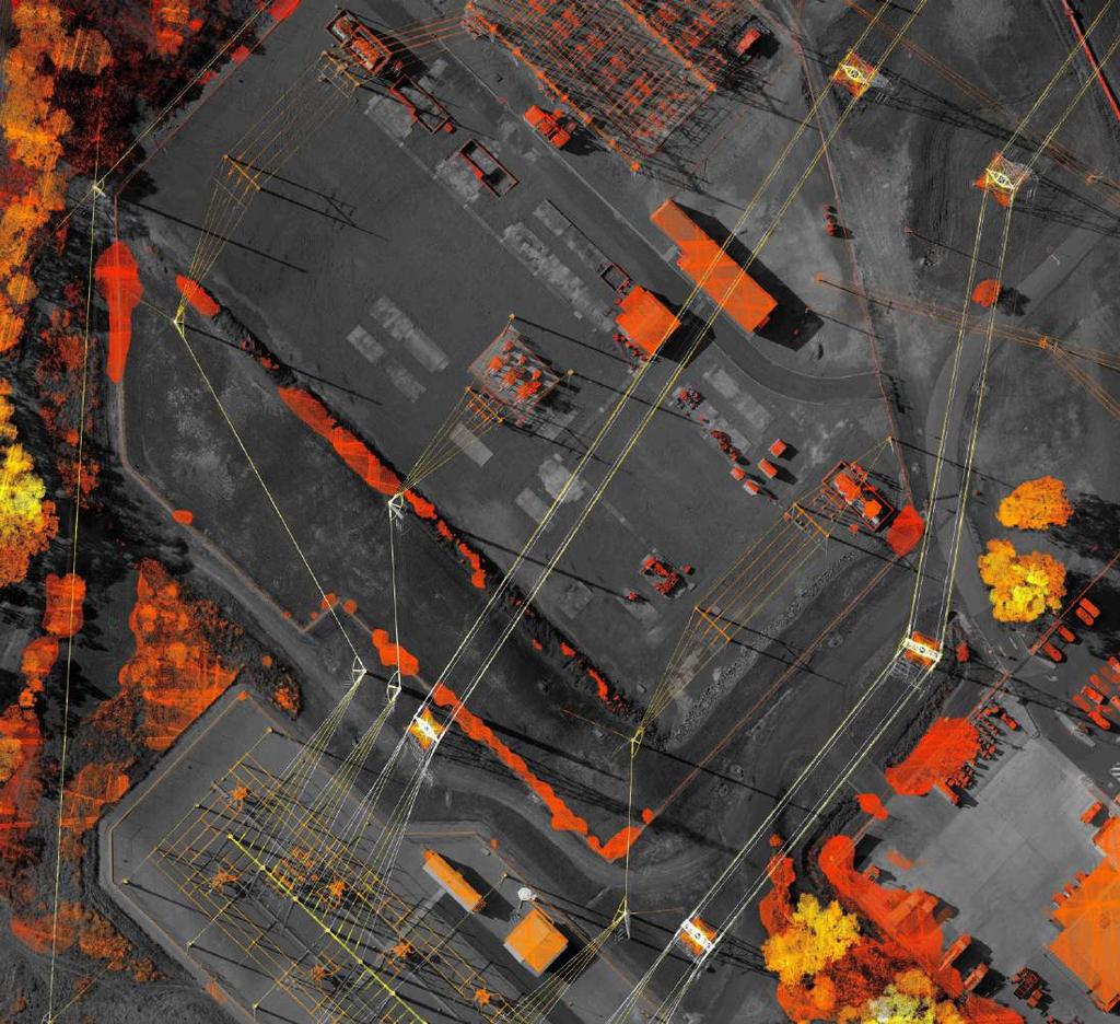
12 Oblique Imagery Digital Surface Models

13 Viewshed Analysis
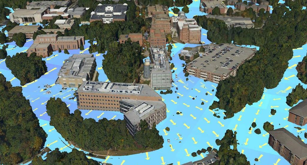
14 Flood Management

15 Coastal Monitoring with Oblique Imagery Technology
16 Roames


17 Roames Overview Roames maintains a 3-D virtual world repository from which it produces asset and environmental assessments. raw Data Roames observations are guaranteed to contain the complete electrical network and surrounding environment including all vegetation, buildings, street-level features and objects. Automatically extract and process data into a 3-D engineering quality model with feature and object detection at a high level of accuracy, timeless and functionality than current available in market. Automatically model and simulate asset conditions and risk, e.g. vegetation management, network faults, and defects. Web-based reporting and visualization tools enable users to visually inspect and assess features of interest. Work program optimization achieved through a complete picture of the network and its condition. raw Data Patent Pending Acquisition Technology Patented Processing and Algorithms Roames internal processes Asset and Risk Reports 3-D Virtual World Visualization Tool Deliver knowledge and solutions
18 Detailed Elevation Data for Mapping Networks

19 Detailed Modeling for Change Analysis

20 GeoSAR
 that operates in two frequency bands. Employed from Fugro s Gulfstream G-II aircraft, it is a one-of-a-kind system, operational since 2003.")
21 The GeoSAR System X-band antennas Antenna positioning measurement unit P-band antennas GeoSAR is an Interferometric Synthetic Aperture Radar System (IFSAR) that operates in two frequency bands. Employed from Fugro s Gulfstream G-II aircraft, it is a one-of-a-kind system, operational since 2003.

 penetrates vegetation, ice, dry soil, to collect terrain")

22 GeoSAR X- and P-band Description X-band (yellow) reflects off of the first surface Produces DSM and magnitude image of surface features (vegetation, houses, roadways) P-band X-band P-band (green) penetrates vegetation, ice, dry soil, to collect terrain features Basis for DTM and magnitude image of underlying features (paths, cultural features, fences, geologic features, most metallic features, wetlands)


 Digital Terrain Model (DTM) X/P Hybrid")
23 GeoSAR Data Products Orthorectified Radar Imagery (ORI) Radar surface reflectance Visualization, mapping, Digital Surface Model (DSM) X-band Orthorectified intensity model Surface reflectance elevation Detailed visualization and analysis Digital Elevation Model (DEM) P-band Represents near bare-earth Derived layers (e.g., slope, contours) Digital Terrain Model (DTM) X/P Hybrid Represents bare-earth
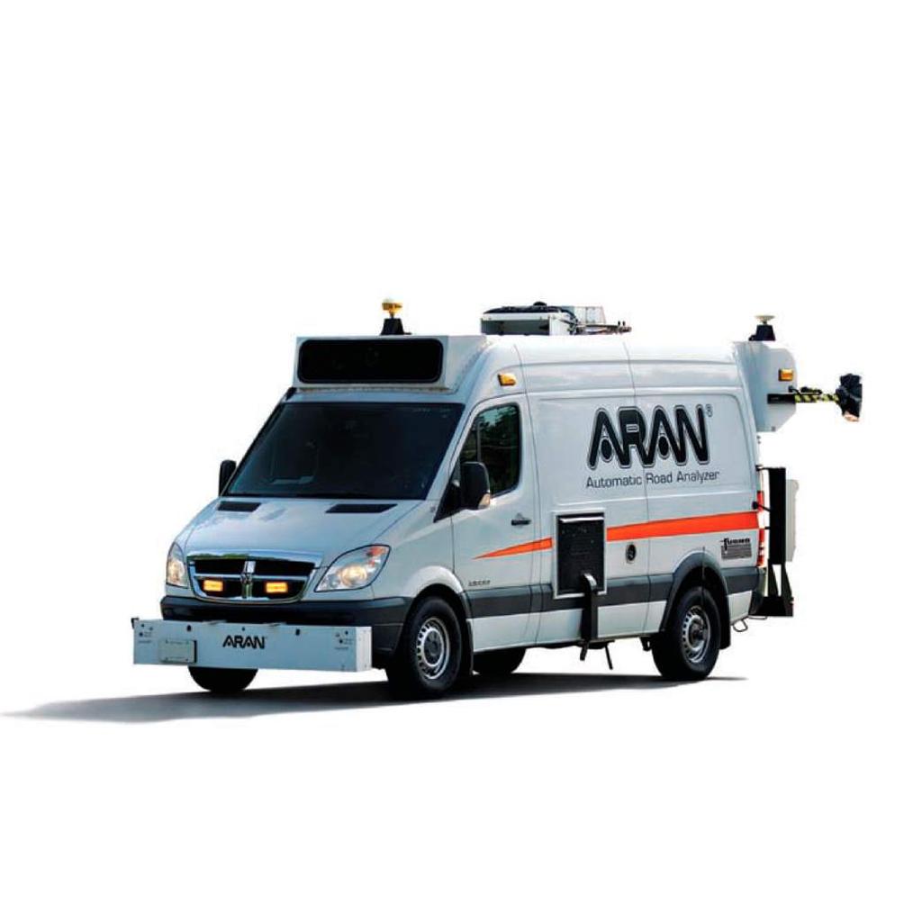
24 Roadware

25 A This is the first ARAN to implement a 4K broadcast quality camera as the primary right-of-way imaging system, providing the clearest views of the highway.

26 Off-shore Survey


27 Example Projects High Resolution Orthoimagery - CAPCOG - FL DOR - USGS - USACE QL2/QL1 Lidar Data - TNRIS - Rapid City, SD - USGS 3DEP - USACE Planimetric Mapping - City of Austin - City of North Myrtle Beach - CAPCOG - City of Edmond (COAGA)


28 Example Projects PG&E Power Distribution Line Mapping PanoramiX High Resolution Oblique Imagery Program Vegetation Related Mapping Projects USDA FIA Plots Fort Bragg Tree Classification


29 Example Projects California Coast Coastal Data Merge Sea grass Mapping


30 Example Projects Search for MH370 ROCIS Ocean Current Monitoring Remote Ocean Current Imaging System Alaska GeoSAR
31 Thank you! Keith Owens Technical and Business Development Manager (301)
Tracy Fuller U. S. Geological Survey. February 24, 2016
 U. S. Geological Survey Arctic Elevation Data Involvement Statewide Alaska IfSAR Radar Collection Program Pan-Arctic Digital Elevation Map International Coordination Tracy Fuller U. S. Geological Survey
3D Elevation Program The Industry Perspective. Amar Nayegandhi, CP, CMS, GISP Vice President, Dewberry Engineers Inc.
 3D Elevation Program The Industry Perspective Amar Nayegandhi, CP, CMS, GISP Vice President, Dewberry Engineers Inc. Dewberry s Geospatial and Technology Services (GTS) Industry-recognized thought leaders,
ELEVATION IS FOUNDATIONAL. A DEM that is inaccurate or of poor resolution will pass those characteristics onto other data layers
 ELEVATION IS FOUNDATIONAL A DEM that is inaccurate or of poor resolution will pass those characteristics onto other data layers THE DEM IS FOUNDATIONAL TO ALL GIS (Geospatial Information System) LAYERS
The 3D Elevation Program: Overview. Jason Stoker USGS National Geospatial Program ESRI 2015 UC
 + The 3D Elevation Program: Overview Jason Stoker USGS National Geospatial Program ESRI 2015 UC + 2 A little history USGS has a long, proud tradition of mapmaking (2009) + 3 The changing times Mapping
MISSOURI LiDAR Stakeholders Meeting
 MISSOURI LiDAR Stakeholders Meeting East-West Gateway June 18, 2010 Tim Haithcoat Missouri GIO Enhanced Elevation Data What s different about it? Business requirements are changing.fast New data collection
NCTCOG Regional GIS Meeting 6-Years and Going Strong. May 15, 2018 hosted by: Tarrant County
 NCTCOG Regional GIS Meeting 6-Years and Going Strong May 15, 2018 hosted by: Tarrant County Woolpert at a Glance 1911 Founded in Dayton, Ohio 25+ Offices across the nation 800+ Global employees 25+ OFFICES
Ramani Geosystems. Putting Africa On The Map. Authorized Resellers
 Ramani Geosystems Putting Africa On The Map Authorized Resellers Ramani Profile Started in 1999 Aerial, Land Surveying & Mapping Solutions + 10 Countries in the region + 80 Staff working in projects Asset
GIS and Remote Sensing
 Spring School Land use and the vulnerability of socio-ecosystems to climate change: remote sensing and modelling techniques GIS and Remote Sensing Katerina Tzavella Project Researcher PhD candidate Technology
ENGRG Introduction to GIS
 ENGRG 59910 Introduction to GIS Michael Piasecki March 17, 2014 Lecture 08: Terrain Analysis Outline: Terrain Analysis Earth Surface Representation Contour TIN Mass Points Digital Elevation Models Slope
STEREO ANALYST FOR ERDAS IMAGINE Stereo Feature Collection for the GIS Professional
 STEREO ANALYST FOR ERDAS IMAGINE Stereo Feature Collection for the GIS Professional STEREO ANALYST FOR ERDAS IMAGINE Has Your GIS Gone Flat? Hexagon Geospatial takes three-dimensional geographic imaging
Use of Elevation Data in NOAA Coastal Mapping Shoreline Products. Coastal GeoTools April 1, 2015
 Use of Elevation Data in NOAA Coastal Mapping Shoreline Products Coastal GeoTools April 1, 2015 - NOAA s Coastal Mapping Program & CUSP - Shoreline Uses, Delineation Issues, Definitions - Current Extraction
3D Elevation Program, Lidar in Missouri. West Central Regional Advanced LiDAR Workshop Ray Fox
 3D Elevation Program, Lidar in Missouri West Central Regional Advanced LiDAR Workshop Ray Fox National Enhanced Elevation Assessment (Dewberry, 2011) Sponsored by the National Digital Elevation Program
GEOMATICS. Shaping our world. A company of
 GEOMATICS Shaping our world A company of OUR EXPERTISE Geomatics Geomatics plays a mayor role in hydropower, land and water resources, urban development, transport & mobility, renewable energy, and infrastructure
ENGRG Introduction to GIS
 ENGRG 59910 Introduction to GIS Michael Piasecki November 17, 2017 Lecture 11: Terrain Analysis Outline: Terrain Analysis Earth Surface Representation Contour TIN Mass Points Digital Elevation Models Slope
VISUALIZING THE SMART CITY 3D SPATIAL INFRASTRUCTURE GEOSMART ASIA- 30 SEP, 2015
 www.aamgroup.com VISUALIZING THE SMART CITY 3D SPATIAL INFRASTRUCTURE GEOSMART ASIA- 30 SEP, 2015 Agenda AAM What is a Smart City? Data Acquisition 3D Modelling Benefits Questions AAM AAM is a Geospatial
Emergency Planning. for the. Democratic National. Convention. imaging notes // Spring 2009 //
 Emergency Planning for the Democratic National Convention The DRAPP Demonstrates Partnership among Local, Regional, State, Utility and Federal Governments 14 imaging notes // Spring 2009 // www.imagingnotes.com
Use of remote sensing for proactive management of geotechnical assets on the strategic road network in England
 Use of remote sensing for proactive management of geotechnical assets on the strategic road network in England Áine Ní Bhreasail Ground Related Risk to Transportation Infrastructure October 26 th -27 th
EMERGENCY PLANNING IN NORTHERN ALGERIA BASED ON REMOTE SENSING DATA IN RESPECT TO TSUNAMI HAZARD PREPAREDNESS
 EMERGENCY PLANNING IN NORTHERN ALGERIA BASED ON REMOTE SENSING DATA IN RESPECT TO TSUNAMI HAZARD PREPAREDNESS Barbara Theilen-Willige Technical University of Berlin, Institute of Applied Geosciences Department
QUESTIONNAIRE THE CURRENT STATUS OF MAPPING IN THE WORLD
 QUESTIONNAIRE ON THE CURRENT STATUS OF MAPPING IN THE WORLD The questionnaire is intended to take stock of the current status of mapping in the world. The information collected will eventually be used
ESRI GIS For Mining Seminar, 10 th August, 2016, Nairobi, Kenya. Spatial DATA Solutions for Mining
 ESRI GIS For Mining Seminar, 10 th August, 2016, Nairobi, Kenya Spatial DATA Solutions for Mining Spatial Data Solutions for Mining Spatial - Data that identifies the geographic location of features &
Technical Drafting, Geographic Information Systems and Computer- Based Cartography
 Technical Drafting, Geographic Information Systems and Computer- Based Cartography Project-Specific and Regional Resource Mapping Services Geographic Information Systems - Spatial Analysis Terrestrial
THE USE OF GEOMATICS IN CULTURAL HERITAGE AND ARCHAEOLOGY FOR VARIOUS PURPOSES
 THE USE OF GEOMATICS IN CULTURAL HERITAGE AND ARCHAEOLOGY FOR VARIOUS PURPOSES FEBRUARY 2013 AL BEIDA GEOPLAN CONTENT Company Profile Concept Objectives and Strategies Data Production Methods Data Samples
Comparison of Intermap 5 m DTM with SRTM 1 second DEM. Jenet Austin and John Gallant. May Report to the Murray Darling Basin Authority
 Comparison of Intermap 5 m DTM with SRTM 1 second DEM Jenet Austin and John Gallant May 2010 Report to the Murray Darling Basin Authority Water for a Healthy Country Flagship Report series ISSN: 1835-095X
DATA APPLIANCE FOR ARCGIS
 DATA APPLIANCE FOR ARCGIS Data Appliance for ArcGIS Provides Access to Multi-Scale Basemaps Down to Medium Scale Levels Worldwide And Large Scale for Most of the World The Data Appliance includes Several
USING GIS CARTOGRAPHIC MODELING TO ANALYSIS SPATIAL DISTRIBUTION OF LANDSLIDE SENSITIVE AREAS IN YANGMINGSHAN NATIONAL PARK, TAIWAN
 CO-145 USING GIS CARTOGRAPHIC MODELING TO ANALYSIS SPATIAL DISTRIBUTION OF LANDSLIDE SENSITIVE AREAS IN YANGMINGSHAN NATIONAL PARK, TAIWAN DING Y.C. Chinese Culture University., TAIPEI, TAIWAN, PROVINCE
Abstracts - Technical Presentations 1 st Joint LiDAR Workshop 29 June 2016
 Abstracts - Technical Presentations 1 st Joint LiDAR Workshop 29 June 2016 10:30 AM Title: The Finer details: Processing algorithm adjustment and point cloud/survey data statistics in wetlands. Authors:
Object Based Imagery Exploration with. Outline
 Object Based Imagery Exploration with Dan Craver Portland State University June 11, 2007 Outline Overview Getting Started Processing and Derivatives Object-oriented classification Literature review Demo
Imagery and the Location-enabled Platform in State and Local Government
 Imagery and the Location-enabled Platform in State and Local Government Fred Limp, Director, CAST Jim Farley, Vice President, Leica Geosystems Oracle Spatial Users Group Denver, March 10, 2005 TM TM Discussion
Yrd. Doç. Dr. Saygın ABDİKAN Öğretim Yılı Güz Dönemi
 Yabancı Dil III (YDL285) Introduction to Geomatics Yrd. Doç. Dr. Saygın ABDİKAN 2017-2018 Öğretim Yılı Güz Dönemi 1 géomatique Geo (Earth) + informatics Geodesy + Geoinformatics Geomatics: The mathematics
Background Unified Mapping Project of NAMRIA Mapping of Typhoon-Affected Areas Final Output Conclusion
 www.namria.gov.ph Background Unified Mapping Project of NAMRIA Mapping of Typhoon-Affected Areas Final Output Conclusion Typhoon Haiyan (local name Yolanda) the deadliest most destructive typhoon in recorded
Geospatial Data, Services, and Products. National Surveying, mapping and geospatial conference
 Geospatial Data, Services, and Products Federal Programs -- USDA NRCS National Surveying, mapping and geospatial conference March 15, 2016 NRCS Applications using Geosaptial Products & Services Field
USGS Hydrography Overview. May 9, 2018
 + 1 USGS Hydrography Overview May 9, 2018 + 2 The National Geospatial Program Provides the geospatial baseline of the Nation s topography, natural landscape and built environment through The National Map,
Chapter 1 Overview of Maps
 Chapter 1 Overview of Maps In this chapter you will learn about: Key points when working with maps General types of maps Incident specific maps Map legend and symbols Map sources A map is a navigational
Introduction. Elevation Data Strategy. Status and Next Steps
 1 2 Introduction Elevation Data Strategy Status and Next Steps 3 Canada is the 2nd largest country in the world - 9.9 million sq km Surrounded by 3 oceans with 202 000 km of coastline Population over 35
MONITORING AND MODELING NATURAL AND ANTHROPOGENIC TERRAIN CHANGE
 MONITORING AND MODELING NATURAL AND ANTHROPOGENIC TERRAIN CHANGE Spatial analysis and simulations of impact on landscape processess Helena MITASOVA, Russell S. HARMON, David BERNSTEIN, Jaroslav HOFIERKA,
Southwestern Ontario Orthophotography Project (SWOOP) 2015 Digital Elevation Model
 2015 Digital Elevation Model") Southwestern Ontario Orthophotography Project (SWOOP) 2015 Digital Elevation Model User Guide Provincial Mapping Unit Mapping and Information Resources Branch Corporate Management and Information Division
Southwestern Ontario Orthophotography Project (SWOOP) 2015 Digital Elevation Model User Guide Provincial Mapping Unit Mapping and Information Resources Branch Corporate Management and Information Division
Esri Image & Mapping Forum 9 July 2017 Geiger-Mode for Conservation Planning & Design by USDA NRCS NGCE
 Esri Image & Mapping Forum 9 July 2017 Geiger-Mode for Conservation Planning & Design by USDA NRCS NGCE For over 75 years, the Natural Resources Conservation Service has been a pioneer in conservation,
Philippines NSDI Foundation Data Program. Andrew Bashfield
 Philippines NSDI Foundation Data Program Andrew Bashfield 1 Overview Part 1: Building the NSDI Framework Part 2: Collecting Foundation Datasets 2 Building the NSDI Framework Background & NDSI Overview
Lesson 4b Remote Sensing and geospatial analysis to integrate observations over larger scales
 Lesson 4b Remote Sensing and geospatial analysis to integrate observations over larger scales We have discussed static sensors, human-based (participatory) sensing, and mobile sensing Remote sensing: Satellite
Lidar-derived Hydrography as a Source for the National Hydrography Dataset
 Lidar-derived Hydrography as a Source for the National Hydrography Dataset Lidar-Derived Hydrography, Bathymetry, and Topobathymetry in the National Hydrography Dataset and 3-Dimensional Elevation Program
Spatial Planning Platform Meeting
 Spatial Planning Platform Meeting August 1 st 2018 Part II Session 1 Design and Implementation of National and Regional Planning for Inclusive Growth Spatial info from space based technologies RESTEC (Remote
Large Scale Elevation Data Assessment of SCOOP 2013 Deliverables. Version 1.1 March 2015
 Large Scale Elevation Data Assessment of SCOOP 2013 Deliverables Version 1.1 March 2015 ACKNOWLEDGEMENTS... 2 EXECUTIVE SUMMARY... 2 1.0 INTRODUCTION... 3 2.0 BACKGROUND... 4 2.1 SOUTH CENTRAL ONTARIO
What s New in Topographic Information - USGS National Map
 + What s New in Topographic Information - USGS National Map SARGIS Workshop November 14, 2016 Rob Dollison, 703-648-5724 rdollison@usgs.gov + USGS 2 National Geospatial Program The National Geospatial
STATE-WIDE HIGH-DENSITY LIDAR IS NOW AVAILABLE GEIGER-MODE LIDAR AND THE MULTI-USE BENEFITS
 Place image here (13.33 x 3.5 ) STATE-WIDE HIGH-DENSITY LIDAR IS NOW AVAILABLE GEIGER-MODE LIDAR AND THE MULTI-USE BENEFITS SCOTT BENNETT Director of Strategic Growth - Geospatial Solutions scott.a.bennett@harris.com
Current and Future Technology Applications for Coastal Zone Management. Bruce K. Carlisle, Acting Director Office of Coastal Zone Management
 Current and Future Technology Applications for Coastal Zone Management Bruce K. Carlisle, Acting Director Office of Coastal Zone Management The Massachusetts Coastal Zone Management Program Approved in
Potential and Accuracy of Digital Landscape Analysis based on high resolution remote sensing data
 'Spatial Information for Sustainable Management of Urban Areas' Mainz, 2-4 February 2009, Germany Potential and Accuracy of Digital Landscape Analysis based on high resolution remote sensing data Dr. Matthias
Integrating LiDAR data into the workflow of cartographic representation.
 Integrating LiDAR data into the workflow of cartographic representation. Cartographic Workflow I. 1 2 3 4 5 Surveying Vector (Nat. GDB) GPS, Laser Range Finder Yes/ No Scanning old maps LiDARflights Capture
State of Israel Ministry of Housing and Construction Survey of Israel. The Hydrological project case
 State of Israel Ministry of Housing and Construction Survey of Israel The Hydrological project case Survey of Israel Content Introduction To the Survey of Israel The operation assumptions The main responsibilities
Mapping Coastal Change Using LiDAR and Multispectral Imagery
 Mapping Coastal Change Using LiDAR and Multispectral Imagery Contributor: Patrick Collins, Technical Solutions Engineer Presented by TABLE OF CONTENTS Introduction... 1 Coastal Change... 1 Mapping Coastal
Summary Visualizations for Coastal Spatial Temporal Dynamics
 Summary Visualizations for Coastal Spatial Temporal Dynamics October 24 2011 Providence, RI Sidharth Thakur 1, Laura Tateosian 2, Helena Mitasova, Eric Hardin, and Margery Overton 1. sthakur@renci.org,
GIS APPLICATIONS IN SOIL SURVEY UPDATES
 GIS APPLICATIONS IN SOIL SURVEY UPDATES ABSTRACT Recent computer hardware and GIS software developments provide new methods that can be used to update existing digital soil surveys. Multi-perspective visualization
IMAGE AND DATA CREDITS
 Image credits All images created by Keranen and Image (figure 03_basics_a.tif) from ArcGIS Help 10.2 http://resources.arcgis.com/en/help /main/10.2/index.html#/015w0000006n000000, courtesy of Esri. Image
LiDAR APPLICATIONS REMS6090. Assignment 2 HYDROLOGICAL APPLICATIONS of LiDAR DATA Due Date April 8, Venessa Bennett W
 LiDAR APPLICATIONS REMS6090 Assignment 2 HYDROLOGICAL APPLICATIONS of LiDAR DATA Due Date April 8, 2015 Venessa Bennett W0279429 1.0 Introduction High accuracy Digital Elevation Models (DEM) derived from
AN EVALUATION OF SRTM, ASTER, AND CONTOUR BASED DEMS IN THE CARIBBEAN REGION
 Peter G. Chirico Geographer USGS, Earth Surface Processes Team 12201 Sunrise Valley Drive National Center, MS926A Reston VA, 20192 pchirico@usgs.gov AN EVALUATION OF SRTM, ASTER, AND CONTOUR BASED DEMS
USING LIDAR MEASUREMENTS FOR IMPROVING OR UP-DATING A DEM
 JAES_1(14)_3_2011 VAIS M. et. all, pp.123-128 SECTION Geodesic Engineering USING LIDAR MEASUREMENTS FOR IMPROVING OR UP-DATING A DEM VAIS Manuel*, IOSIF Gheorghe, Bucharest University, *e-mail: manuel.vais@sipg.ro
Quick Response Report #126 Hurricane Floyd Flood Mapping Integrating Landsat 7 TM Satellite Imagery and DEM Data
 Quick Response Report #126 Hurricane Floyd Flood Mapping Integrating Landsat 7 TM Satellite Imagery and DEM Data Jeffrey D. Colby Yong Wang Karen Mulcahy Department of Geography East Carolina University
Coastal Zone Mapping and Imaging Lidar (CZMIL)
") Coastal Zone Mapping (CZMIL) Shallow Survey 2012 Wellington, New Zealand Christopher L. Macon U.S. Army Corps of Engineers, Mobile District Joint Airborne Lidar Bathymetry Technical Center of expertise
Coastal Zone Mapping (CZMIL) Shallow Survey 2012 Wellington, New Zealand Christopher L. Macon U.S. Army Corps of Engineers, Mobile District Joint Airborne Lidar Bathymetry Technical Center of expertise
Land Use MTRI Documenting Land Use and Land Cover Conditions Synthesis Report
 Colin Brooks, Rick Powell, Laura Bourgeau-Chavez, and Dr. Robert Shuchman Michigan Tech Research Institute (MTRI) Project Introduction Transportation projects require detailed environmental information
This module presents remotely sensed assessment (choice of sensors and resolutions; airborne or ground based sensors; ground truthing)
") This module presents remotely sensed assessment (choice of sensors and resolutions; airborne or ground based sensors; ground truthing) 1 In this presentation you will be introduced to approaches for using
This module presents remotely sensed assessment (choice of sensors and resolutions; airborne or ground based sensors; ground truthing) 1 In this presentation you will be introduced to approaches for using
Overview of Remote Sensing in Natural Resources Mapping
 Overview of Remote Sensing in Natural Resources Mapping What is remote sensing? Why remote sensing? Examples of remote sensing in natural resources mapping Class goals What is Remote Sensing A remote sensing
Workshops funded by the Minnesota Environment and Natural Resources Trust Fund
 Workshops funded by the Minnesota Environment and Natural Resources Trust Fund Conservation Applications of LiDAR Data Workshops funded by: Minnesota Environment and Natural Resources Trust Fund Presented
MAPPS/USGS Liaison Meeting U.S. Department of the Interior U.S. Geological Survey
 MAPPS/USGS Liaison Meeting U.S. Department of the Interior U.S. Geological Survey Kevin Gallagher, Associate Director, Core Science Systems Greg Stensaas, Earth Resources and Observation Science Center
Landslide Mapping and Hazard Analysis for a Natural Gas Pipeline Project
 CIVIL GOVERNMENT SERVICES MINING & METALS OIL, GAS & CHEMICALS POWER Albert Kottke, Mark Lee, & Matthew Waterman Landslide Mapping and Hazard Analysis for a Natural Gas Pipeline Project Technical Innovation
P R O U D LY C A N A D I A N
 P R O U D LY C A N A D I A N 1.855.423.3185 info@rmegeomatics.com AERIAL SURVEYING IMAGING TERRAIN ANALYSIS WHO WE ARE HSE & REGULATORY CLIENT INDUSTRIES RME Geomatics (formerly NGF Geomatics) was founded
Presented by: Ki r k Cont r ucci, CP Ayres Associates. Andy Faust, GISP North Central Wisconsin Regional Planning Commission.
 Andy Faust, GISP North Central Wisconsin Regional Planning Commission Presented by: Ki r k Cont r ucci, CP Ayres Associates Zach Nienow Ayres Associates Adam Derringer, GISP Ayres Associates Type questions
Applying Hazard Maps to Urban Planning
 Applying Hazard Maps to Urban Planning September 10th, 2014 SAKAI Yuko Disaster Management Expert JICA Study Team for the Metro Cebu Roadmap Study on the Sustainable Urban Development 1 Contents 1. Outline
Radar Remote Sensing: Monitoring Ground Deformations and Geohazards from Space
 Radar Remote Sensing: Monitoring Ground Deformations and Geohazards from Space Xiaoli Ding Department of Land Surveying and Geo-Informatics The Hong Kong Polytechnic University A Question 100 km 100 km
To achieve these Global Sustainable Development Goals, geospatial data are crucial.
 To achieve these Global Sustainable Development Goals, geospatial data are crucial. 2 http://www.globalgoals.org/ HIGH INCOME NATION SUSTAINABLE GROWTH SOCIALLY INCLUSIVE 3 http://etp.pemandu.gov.my/ 12
Lecture 9: Reference Maps & Aerial Photography
 Lecture 9: Reference Maps & Aerial Photography I. Overview of Reference and Topographic Maps There are two basic types of maps? Reference Maps - General purpose maps & Thematic Maps - maps made for a specific
Algorithms for GIS csci3225
 Algorithms for GIS csci3225 Laura Toma Bowdoin College Spatial analysis: the beginnings Finding: nb. cholera deaths aer spatially clustered around the Broad St pump 1848, London, John Snow Claim: Cholera
DRAPE 2014 Digital Elevation Model
 DRAPE 2014 Digital Elevation Model User Guide Spatial Data Infrastructure Mapping and Information Resources Branch Corporate Management and Information Division Ministry of Natural Resources and Forestry
Copernicus Overview. Major Emergency Management Conference Athlone 2017
 Copernicus Overview Major Emergency Management Conference Athlone 2017 Copernicus is a European programme implemented by the European Commission. The services address six thematic areas: land, marine,
Applications of GIS in assessing Coastal Change Rachel Hehre November 30, 2004 NRS 509 OVERVIEW
 Applications of GIS in assessing Coastal Change Rachel Hehre November 30, 2004 NRS 509 OVERVIEW ITRODUCTION Due to the dynamic nature of coastal systems, representing coastal change with precision and
Creating Watersheds and Stream Networks. Steve Kopp
 Creating Watersheds and Stream Networks Steve Kopp Workshop Overview Demo Data Understanding the tools Elevation Data Types DEM : Digital Elevation Model bare Earth DSM : Digital Surface Model Data Structure
How to Construct Urban Three Dimensional GIS Model based on ArcView 3D Analysis
 How to Construct Urban Three Dimensional GIS Model based on ArcView 3D Analysis Ko Ko Lwin Division of Spatial Information Science Graduate School of Life and Environmental Sciences University of Tsukuba
Papua New Guinea LiDAR Factsheet. Pacific-Australia Climate Change Science and Adaptation Planning. Vanimo. Bismark Sea. Wewak
 Pacific-Australia Climate Change Science and Adaptation Planning INDONESIA Vanimo Ninigo Group Wewak Madang Mount Hagen Kundiawa Goroka Mendi Daru AUSTRALIA Kerema Gulf of Papua Admiralty Islands Mussau
Remote Sensing and Geospatial Application for Wetlands Mapping, Assessment, and Mitigation
 Remote Sensing and Geospatial Application for Wetlands Mapping, Assessment, and Mitigation Hydrology Soils MSU Seminar Series Remote Sensing and Geospatial Applications September 4, 2002 Vegetation NEPA
U.S. Geological Survey Agency Briefing for MAPPS Mark L. DeMulder Director, National Geospatial Program. March 12, 2013
 + U.S. Geological Survey Agency Briefing for MAPPS Mark L. DeMulder Director, National Geospatial Program March 12, 2013 + 3D Elevation Program (3DEP) National Leadership The National Enhanced Elevation
Remote Sensing and Incident Support. Department of Homeland Security February 22, 2013
 Remote Sensing and Incident Support Department of Homeland Security February 22, 2013 Introductions and Goals Today s Webcast will be Presented by: Chris Barnard DHS Remote Sensing Advisor Chris Vaughan
Spanish national plan for land observation: new collaborative production system in Europe
 ADVANCE UNEDITED VERSION UNITED NATIONS E/CONF.103/5/Add.1 Economic and Social Affairs 9 July 2013 Tenth United Nations Regional Cartographic Conference for the Americas New York, 19-23, August 2013 Item
GERSVIEW: A New Database for Web Mapping
 GERSVIEW: A New Database for Web Mapping William J. Hernández, M.S. Graduate Student Department of Marine Sciences-UPRM Fernando Gilbes, Ph.D. Associate Professor Department of Geology-UPRM Overview Introduction
Module 2 Educator s Guide Investigation 2
 Module 2 Educator s Guide Investigation 2 How does remote sensing help us to observe human activities on Earth? Investigation Overview Landscapes that are influenced by human activities are found nearly
THE ESTABLISHMENT OF DIGITAL HIGH RESOLUTION GEODATABASES FOR WEBGIS: FROM DIGITAL CAMPUS TO DIGITAL NATIONAL PARK
 THE ESTABLISHMENT OF DIGITAL HIGH RESOLUTION GEODATABASES FOR WEBGIS: FROM DIGITAL CAMPUS TO DIGITAL NATIONAL PARK Y. C. Ding a, *, C. C. Huang a a Digital Earth Research Center (DERC), Chinese Culture
The Future of Soil Mapping using LiDAR Technology
 The Future of Soil Mapping using LiDAR Technology Jessica Philippe Soil Scientist/GIS Specialist March 24, 2016 Natural Resources Conservation Service Helping People Help the Land Area 12-STJ covers parts
JALBTCX AND THE USACE NATIONAL COASTAL MAPPING PROGRAM
 JALBTCX AND THE USACE NATIONAL COASTAL MAPPING PROGRAM 237 237 237 217 217 217 200 200 200 80 119 27 252 174.59 1 255 255 255 0 0 0 163 163 163 131 132 122 239 65 53 110 135 120 112 92 56 62 102 130 102
RADAR Remote Sensing Application Examples
 RADAR Remote Sensing Application Examples! All-weather capability: Microwave penetrates clouds! Construction of short-interval time series through cloud cover - crop-growth cycle! Roughness - Land cover,
Remote Sensing / GIS Conference. The Louisiana Proposed Elevation for the Nation Business Plan Components
 Remote Sensing / GIS Conference 08 April 2008 The Louisiana Proposed Elevation for the Nation Business Plan Components David Gisclair, Louisiana Oil Spill Coordinators Office, Office of the Governor david.gisclair@la.gov
GIS Techniques for Floodplain Delineation. Dean Djokic
 GIS Techniques for Floodplain Delineation Dean Djokic (ddjokic@esri.com) Content What is a floodplain? How to get a floodplain? What can GIS do for floodplain modeling? Simple GIS techniques for floodplain
Using Remote Piloted Aircraft for Seawall Condition Assessment
 Using Remote Piloted Aircraft for Seawall Condition Assessment Moreton Bay Regional Council Shamim Yazdani Senior Engineer - Stormwater Planning DJI Industries Phantom FC-40 remotely-piloted aircraft 1
Great Lakes Update. Geospatial Technologies for Great Lakes Water Management. Volume 149 October 4, US Army Corps of Engineers Detroit District
 Volume 149 October 4, 2002 US Army Corps of Engineers Detroit District Great Lakes Update Geospatial Technologies for Great Lakes Water Management The U.S. Army Corps of Engineers (USACE) serves an important
Effective Utilization of Synthetic Aperture Radar (SAR) Imagery in Rapid Damage Assessment
 Imagery in Rapid Damage Assessment") Effective Utilization of Synthetic Aperture Radar (SAR) Imagery in Rapid Damage Assessment Case Study Pakistan Floods SUPARCO M. Maisam Raza, Ahmad H. Rabbani SEQUENCE Flood Monitoring using Satellite
Effective Utilization of Synthetic Aperture Radar (SAR) Imagery in Rapid Damage Assessment Case Study Pakistan Floods SUPARCO M. Maisam Raza, Ahmad H. Rabbani SEQUENCE Flood Monitoring using Satellite
NEEA Refresh aka 3D Nation Requirements and Benefits Study. Allyson Jason, Carol Ostergren, Xan Fredericks and Lou Driber November 9, 2017
 + NEEA Refresh aka 3D Nation Requirements and Benefits Study Allyson Jason, Carol Ostergren, Xan Fredericks and Lou Driber November 9, 2017 + 2 Study Context Background The National Enhanced Elevation
Graduate Courses Meteorology / Atmospheric Science UNC Charlotte
 Graduate Courses Meteorology / Atmospheric Science UNC Charlotte In order to inform prospective M.S. Earth Science students as to what graduate-level courses are offered across the broad disciplines of
DAMAGE DETECTION OF THE 2008 SICHUAN, CHINA EARTHQUAKE FROM ALOS OPTICAL IMAGES
 DAMAGE DETECTION OF THE 2008 SICHUAN, CHINA EARTHQUAKE FROM ALOS OPTICAL IMAGES Wen Liu, Fumio Yamazaki Department of Urban Environment Systems, Graduate School of Engineering, Chiba University, 1-33,
Background. Points of Discussion. Hydrographic Models
 Airborne Laser Remote Sensing Technology: Providing Essential Hydrologic Information in the 21 st Century Warwick Hadley, Optech Incorporated Presented by: Warwick Hadley Sales Manager, Middle East and
2 nd Japan and Republic of Korea LiDAR Survey Symposium
 2 nd Japan and Republic of Korea LiDAR Survey Symposium 2010 年 9 月 20 日 Prof. Woosug Cho wcho@inha.ac.kr Spacematics Lab Department of Civil Engineering Inha University Presentation on Current Status in
Mapping for a Changing California
 Mapping for a Changing California Spatial Data Science: - the 21 st century mapping toolkit - case studies in remote sensing and participatory informatics -where to get more information Maggi Kelly, University
Detection of Slope Instability using 3D LiDAR Modelling
 Detection of Slope Instability using 3D LiDAR Modelling Duffell CG 1, Rudrum DM 2 and Willis MR 3 1 Technical Adviser (Geotechnics), Highways Agency. City Tower, Piccadilly Plaza, Manchester, M1 4BE, United
USGS National Geospatial Program Understanding User Needs. Dick Vraga National Map Liaison for Federal Agencies July 2015
 + USGS National Geospatial Program Understanding User Needs Dick Vraga National Map Liaison for Federal Agencies July 2015 + Topics 2 Background Communities of Use User Surveys National Map Liaisons Partnerships
Application of high-resolution (10 m) DEM on Flood Disaster in 3D-GIS
 DEM on Flood Disaster in 3D-GIS") Risk Analysis V: Simulation and Hazard Mitigation 263 Application of high-resolution (10 m) DEM on Flood Disaster in 3D-GIS M. Mori Department of Information and Computer Science, Kinki University, Japan
Risk Analysis V: Simulation and Hazard Mitigation 263 Application of high-resolution (10 m) DEM on Flood Disaster in 3D-GIS M. Mori Department of Information and Computer Science, Kinki University, Japan