Manitoba s Elevation (LiDAR) & Imagery Datasets. Acquisition Plans & Opportunities for Collaboration
|
|
|
- Marylou Rose
- 6 years ago
- Views:
Transcription

1 Manitoba s Elevation (LiDAR) & Imagery Datasets Acquisition Plans & Opportunities for Collaboration Manitoba Planning Conference May 2017
2 Presentation Outline Manitoba s Elevation (LiDAR) and Imagery Datasets GOM Planning and Applications Acquisition Plan(s) to Update Datasets Examples of Collaboration Questions
3 Elevation Information

4 Current Digital Elevation Model Datasets Shuttle Radar Topography Mission (SRTM): 90m DEM Collected in 2000 Horizontal accuracy <=20m Vertical accuracy Absolute <=16m Relative <=10m

5 Current Digital Elevation Model Datasets Southern Manitoba 100m DEM Published 2002 Derived from 2m Orthos, supplemented with NTS contour lines Horizontal accuracy <=100m Vertical accuracy <=3m
6 Current Digital Elevation Model Datasets Ortho Refresh derived 15m DEM Collected Horizontal accuracy <=1.5m Vertical accuracy <=1.5m
7 7 Needs and requirements Elevation data is essential for many applications: Flood Plain Mapping and Mitigation Strategies, Surface Water Management, Infrastructure Development/Management, Disaster Management and Recovery Most of these applications now require base data with greater resolution, (starting with imagery and elevation information).

8 2011 Flood Demonstrated Need for Enhanced Elevation Information Lake St. Martin LiDAR will enable: Mapping of sites for land exchange with First Nation Investigation into emergency reduction of Lake Manitoba and Lake St. Martin levels Flood mitigation Hydraulic modelling Defining the Lake St. Martin and Dauphin River Financial Assistance Program area Lake St. Martin First Nation: June 23, 2011.

9 LiDAR-Elevation Information Light Detection And Ranging Laser pulse emitted and the time it takes to strike an object and return is measured.
10 LiDAR Advantages High accuracy Fast acquisition and processing Minimum human dependence Light independence: day/night collection Canopy penetration High data density (3D data)

11 LiDAR Data-GOM Applications


12 Potential Retention Storage Assessments using Lidar data


13 Potential Water Retention Sites in Roseau River

14 Potential Water Retention Sites in Cooks Creek Watershed
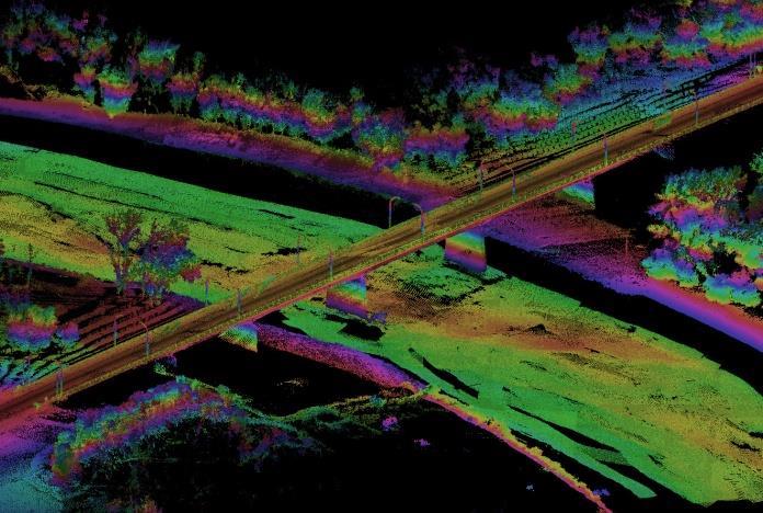
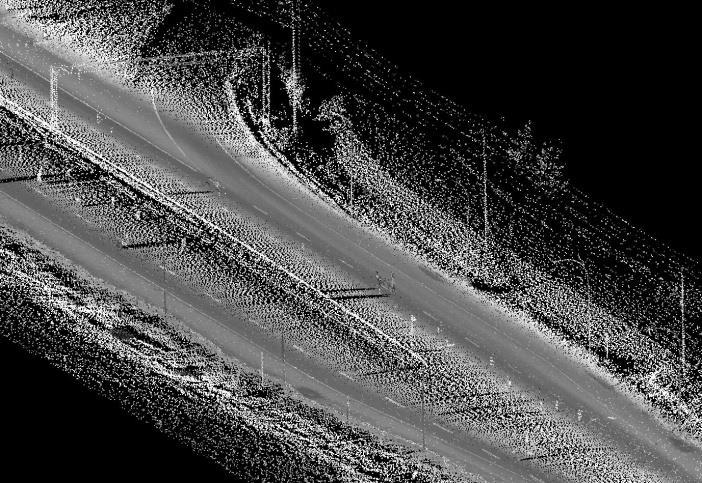
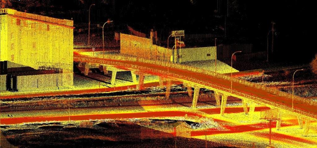
15 Transportation


16 Forestry

17 Community Planning-Subdivisions The long-term embankment movement , has, at its most extreme, averaged 5 feet per year.


18 Traverse Bay: Lake Winnipeg November 2009

19 Flood Extent 1950, 1997, 2009 & 2011
20
21
22
23

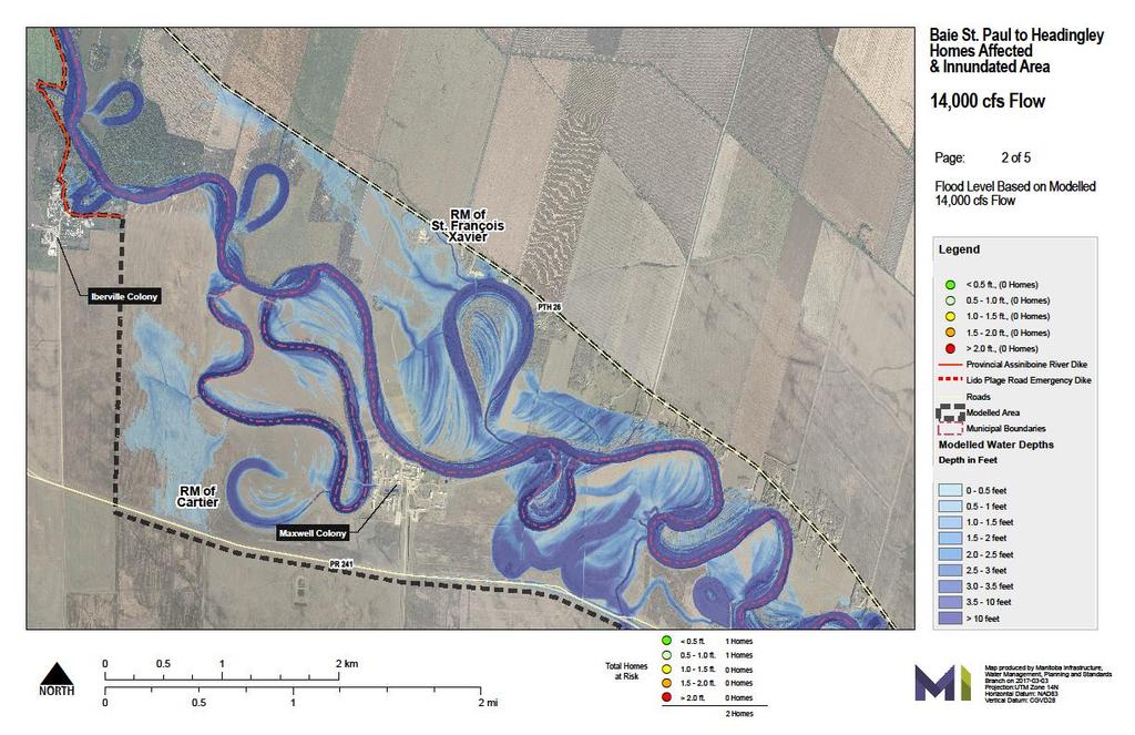
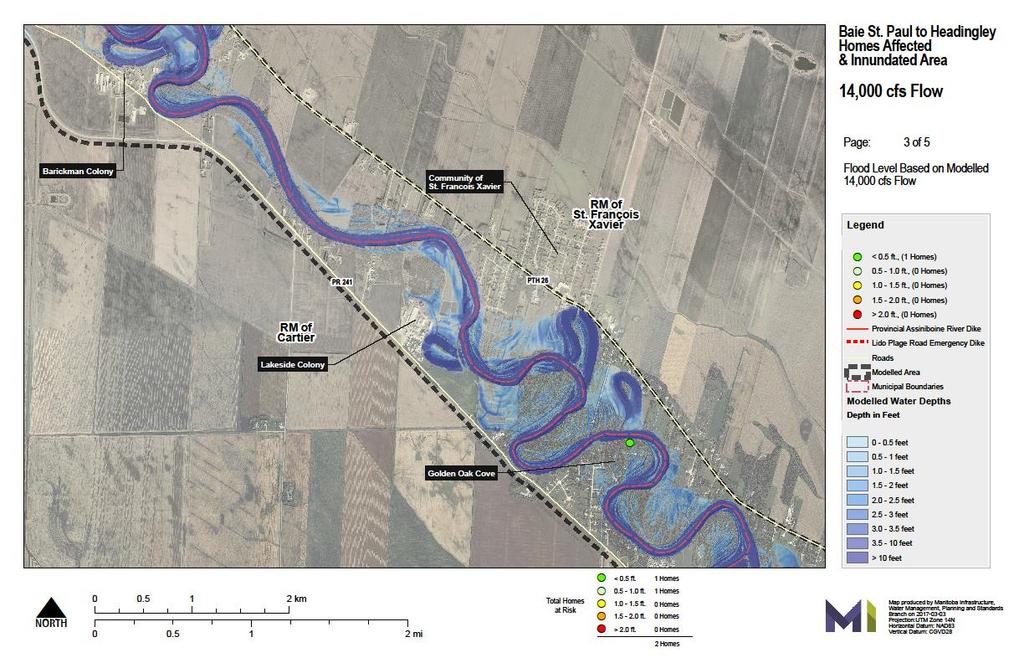
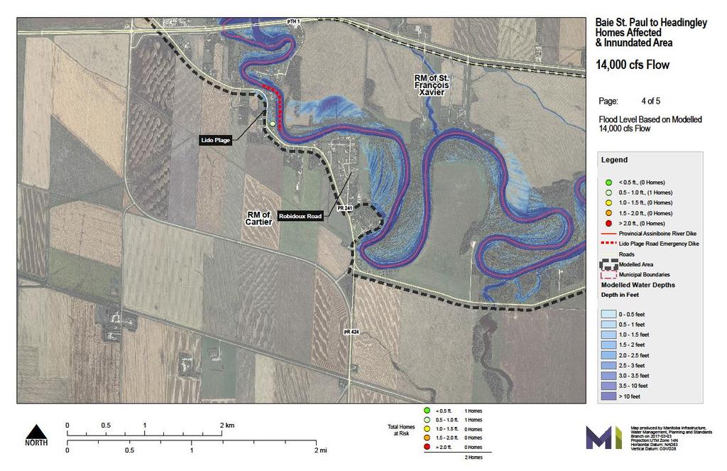
24 Aerial Photography + LiDAR = Powerful Tool in Flood Preparedness Sample of information provided to landowners via Flood Liaison Offices 2009 flood imagery 1997 flood level
25
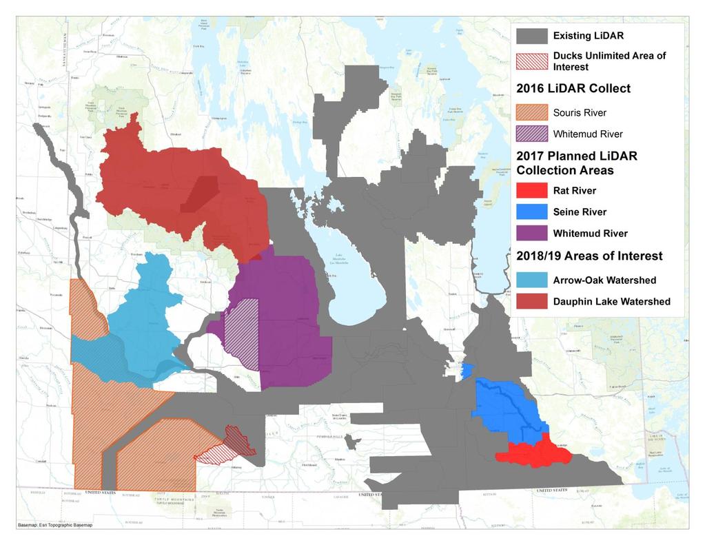
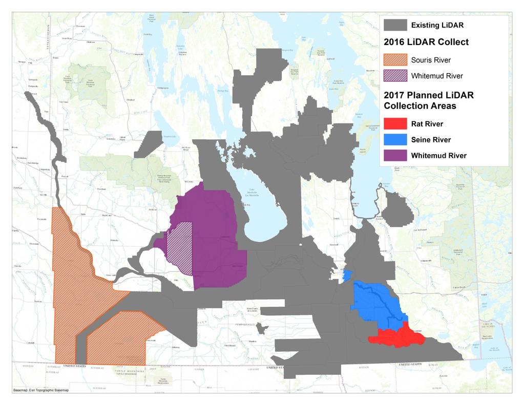
26

27

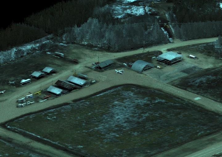
28 Opportunities for Collaboration

29 LiDAR Capture Partnership Cooks-Devils Creek Watershed RM Springfield RM Tache Cooks Creek Conservation District Province of Manitoba

30 Public Safety Canada s National Disaster Mitigation Program 50/50 Federal/Provincial funding to reduce the impacts of natural disasters on Canadians. Under this program there are 4 funding streams; risk assessment, flood mapping, mitigation planning and non-structural and small scale mitigation projects. Currently there is a signed Contribution Agreement for flood risk mapping which includes hydrologic and hydraulic analysis, data capture.
31 2 yr LiDAR Contribution Agreement
32

33 2017 Proposed LiDAR Acquisition Seine and Rat River Watersheds
34 Seine and Rat River Watersheds-Possible RM & CD Partnerships Model 1: Municipality Area Based Calculation Model 2: Crown vs Private Assessment on Total Cost Model 3: Crown vs Private Assessment where province pays 100% on crown lands plus 50% on private
35 Imagery Datasets-Ortho-Photography


36 Air Photo Library Past and Future Prevents deterioration of negatives and photos from handling and age Decreases search time Increases staff efficiency Georeferencing photos Negatives scanned at 1200 dpi. Each roll takes a minimum 30 hours scanning time up to 7 days rolls of negatives in storage

37 Manitoba Orthophoto Program Grey scale 2 metre resolution
38 Manitoba Ortho Refresh Program $1.2 Million True colour 50 cm resolution Partnership- 6 Departments, Crown Corporation, Federal Government and Forestry Industry
39 Manitoba Ortho-Photography

40 Imagery Acquisition- 2 Options Under Consideration


41 High Resolution Optical Imagery Acquisition

42 Satellite Imagery Benefits Coverage Cost Frequency of data capture
43

44 44 High Resolution Satellite Imagery-Next Steps Confirm and Finalize Imagery Specifications Finalize RFP and Tender Assessment Criteria Confirm Funding Possible Fall Release Her Majesty the Queen in Right of Canada, as represented by the Minister of Natural Resources, 2016
45 Option 2 Multi-Year Ortho Photography Program
46 Option 2 Orthophotography Renewal Project- Southern Manitoba Manitoba Geospatial Information Committee (MaGIC) Determined Area of Interest & Target Start FY 2018-? Updating Ortho Specifications Communication-Preparing Orthophotography Fact Sheet Investigate Collaboration and Partnership Opportunities Develop Acquisition Strategy, Determine Costs, RFP, etc.

47 Summer/Fall Decision

48 Manitoba Land Initiative-Open Data Cross-department partnership project Database of government s land related information Accessible by public and government agencies Over 20,000 registrants

49 Manitoba Land Initiative-Open Data


50 MLI Sample Datasets Provincial Boundary Municipal Boundaries Parks and Park Reserves Protected Areas Soils Forest Inventory Cadastral Quarter Section Grids Digital Orthophotos LiDAR Soils Agricultural Interpretation Database
51 Questions? Imagery Acquisition LiDAR Acquisition
Introduction. Elevation Data Strategy. Status and Next Steps
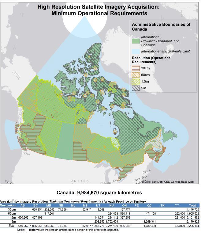
 1 2 Introduction Elevation Data Strategy Status and Next Steps 3 Canada is the 2nd largest country in the world - 9.9 million sq km Surrounded by 3 oceans with 202 000 km of coastline Population over 35
USGS Hydrography Overview. May 9, 2018
 + 1 USGS Hydrography Overview May 9, 2018 + 2 The National Geospatial Program Provides the geospatial baseline of the Nation s topography, natural landscape and built environment through The National Map,
Emergency Planning. for the. Democratic National. Convention. imaging notes // Spring 2009 //
 Emergency Planning for the Democratic National Convention The DRAPP Demonstrates Partnership among Local, Regional, State, Utility and Federal Governments 14 imaging notes // Spring 2009 // www.imagingnotes.com
Pierce Cedar Creek Institute GIS Development Final Report. Grand Valley State University
 Pierce Cedar Creek Institute GIS Development Final Report Grand Valley State University Major Goals of Project The two primary goals of the project were to provide Matt VanPortfliet, GVSU student, the
Impact Policies Enabling Value Enhancement of Geospatial Information in Canadian Economy and Society
 1 Impact Policies Enabling Value Enhancement of Geospatial Information in Canadian Economy and Society May 26, 2015 Prashant Shukle, Director General Canada Centre for Mapping and Earth Observation Increased
DRAPE 2014 Digital Elevation Model
 DRAPE 2014 Digital Elevation Model User Guide Spatial Data Infrastructure Mapping and Information Resources Branch Corporate Management and Information Division Ministry of Natural Resources and Forestry
GEOMATICS. Shaping our world. A company of
 GEOMATICS Shaping our world A company of OUR EXPERTISE Geomatics Geomatics plays a mayor role in hydropower, land and water resources, urban development, transport & mobility, renewable energy, and infrastructure
3D Elevation Program, Lidar in Missouri. West Central Regional Advanced LiDAR Workshop Ray Fox
 3D Elevation Program, Lidar in Missouri West Central Regional Advanced LiDAR Workshop Ray Fox National Enhanced Elevation Assessment (Dewberry, 2011) Sponsored by the National Digital Elevation Program
GIS Changing the World GIS Day November 15, 2017
 + GIS Changing the World GIS Day November 15, 2017 + Growing Up On The Farm 3 Geographic Information in DNR A 75 year history of mapping and GIS. Forest type map from 1944. State of Washington - Division
Statewide Topographic Mapping Program
 Statewide Topographic Mapping Program February 28, 2018 www.dotd.la.gov Outline Purpose of the Statewide Topographic Mapping Program History Breakdown of R.S. 48:36 - Topographic Mapping Statewide Topographic
Community Discovery Data Questionnaire
 Region III Community Discovery Data Questionnaire Thank you for taking the time to complete this questionnaire. It will provide important information to help FEMA understand flood risk issues in the Conococheague-Opequon
Exploring GIS Potential for Northwestern Ontario Land Information Ontario
 Exploring GIS Potential for Northwestern Ontario Land Information Ontario May 13, 2015 The LIO Vision LIO Vision: That all geographic information about Ontario is fully integrated and accessible LIO Goal:
NEEA Refresh aka 3D Nation Requirements and Benefits Study. Allyson Jason, Carol Ostergren, Xan Fredericks and Lou Driber November 9, 2017
 + NEEA Refresh aka 3D Nation Requirements and Benefits Study Allyson Jason, Carol Ostergren, Xan Fredericks and Lou Driber November 9, 2017 + 2 Study Context Background The National Enhanced Elevation
Challenges and Potentials of Place Based Information Management in Nepal"
 Nineteenth United Nations Regional Cartographic Conference for Asia and the Pacific, Bangkok, Thailand, 29 October 1 November 2012 Challenges and Potentials of Place Based Information Management in Nepal"
GIS and Remote Sensing
 Spring School Land use and the vulnerability of socio-ecosystems to climate change: remote sensing and modelling techniques GIS and Remote Sensing Katerina Tzavella Project Researcher PhD candidate Technology
Hydrologic Forecast Centre. Manitoba Infrastructure. Winnipeg, Manitoba FEBRUARY FLOOD OUTLOOK REPORT FOR MANITOBA.
 Page 1 of 20 Hydrologic Forecast Centre Manitoba Infrastructure Winnipeg, Manitoba FEBRUARY FLOOD OUTLOOK REPORT FOR MANITOBA February 28, 2019 Overview The February Outlook Report prepared by the Hydrologic
1 Complementary Access Tools
 ENERGY IHS AccuMap Shaped by industry and powered by IHS Markit information, AccuMap is a powerful and intuitive interpretation solution for the Canadian Energy Industry. 1 Complementary Access Tools AccuLogs
The 3D Elevation Program: Overview. Jason Stoker USGS National Geospatial Program ESRI 2015 UC
 + The 3D Elevation Program: Overview Jason Stoker USGS National Geospatial Program ESRI 2015 UC + 2 A little history USGS has a long, proud tradition of mapmaking (2009) + 3 The changing times Mapping
1. Which agency in your state is PRIMARILY responsible for archiving geospatial data and managing archived geo records? (choose one) nmlkj.
 nmlkj.") Survey Intro Kentucky, North Carolina, and Utah are partnering with the Library of Congress as part of the National Digital Information Infrastructure and Preservation Program (NDIIPP) to examine the current
Survey Intro Kentucky, North Carolina, and Utah are partnering with the Library of Congress as part of the National Digital Information Infrastructure and Preservation Program (NDIIPP) to examine the current
Discovery Data Questionnaire
 Region III Discovery Data Questionnaire Thank you for taking the time to complete this Discovery Data questionnaire. It will provide important information to help FEMA better understand flood risk issues
Hydrologic Forecast Centre Manitoba Infrastructure, Winnipeg, Manitoba. FEBRUARY OUTLOOK REPORT FOR MANITOBA February 23, 2018
 Page 1 of 17 Hydrologic Forecast Centre Manitoba Infrastructure, Winnipeg, Manitoba FEBRUARY OUTLOOK REPORT FOR MANITOBA February 23, 2018 Overview The February Outlook Report prepared by the Hydrologic
Sustainable and Harmonised Development for Smart Cities The Role of Geospatial Reference Data. Peter Creuzer
 Sustainable and Harmonised Development for Smart Cities The Role of Geospatial Reference Data Peter Creuzer 1. Introduction - Smart Cities and Geodata 2. Geodata in Germany 3. Examples 4. Data and Service
Roles of NGII in successful disaster management
 The Second UN-GGIM-AP Plenary Meeting Roles of NGII in successful disaster management Republic of Korea Teheran Iran 28 October 2013 Sanghoon Lee, Ph.D. NGII Outline Type of Disasters Occur in Korea Practical
EO Information Services. Assessing Vulnerability in the metropolitan area of Rio de Janeiro (Floods & Landslides) Project
 Project") EO Information Services in support of Assessing Vulnerability in the metropolitan area of Rio de Janeiro (Floods & Landslides) Project Ricardo Armas, Critical Software SA Haris Kontoes, ISARS NOA World
EO Information Services in support of Assessing Vulnerability in the metropolitan area of Rio de Janeiro (Floods & Landslides) Project Ricardo Armas, Critical Software SA Haris Kontoes, ISARS NOA World
08/01/2012. LiDAR. LiDAR Benefits. LiDAR-BASED DELINEATION OF WETLAND BORDERS. CCFFR-2012 Society for Canadian Limnologists:
 LiDAR CCFFR-2012 Society for Canadian Limnologists: Science for Wetland Policy and Management LiDAR-BASED DELINEATION OF WETLAND BORDERS Distance from laser to ground and back again: Determined as laser-pulse
3D Elevation Program- Status and Updates. Oklahoma GI Council Meeting November 2, 2018 Claire DeVaughan US Geological Survey
 + 1 3D Elevation Program- Status and Updates Oklahoma GI Council Meeting November 2, 2018 Claire DeVaughan US Geological Survey + 2 3D Elevation Program (3DEP) Goals Complete acquisition in 8 years Address
Georeferencing and Satellite Image Support: Lessons learned, Challenges and Opportunities
 Georeferencing and Satellite Image Support: Lessons learned, Challenges and Opportunities Shirish Ravan shirish.ravan@unoosa.org UN-SPIDER United Nations Office for Outer Space Affairs (UNOOSA) UN-SPIDER
LIDAR: Statutory Compliance Benefits for Nebraska Natural Resources
 LIDAR: Statutory Compliance Benefits for Nebraska Natural Resources 2011 Nebraska GIS Symposium La Vista, NE April 21, 2011 Doug Hallum, P.G. Integrated Water Management Coordinator Nebraska Department
MISSOURI LiDAR Stakeholders Meeting
 MISSOURI LiDAR Stakeholders Meeting East-West Gateway June 18, 2010 Tim Haithcoat Missouri GIO Enhanced Elevation Data What s different about it? Business requirements are changing.fast New data collection
USGS National Geospatial Program Understanding User Needs. Dick Vraga National Map Liaison for Federal Agencies July 2015
 + USGS National Geospatial Program Understanding User Needs Dick Vraga National Map Liaison for Federal Agencies July 2015 + Topics 2 Background Communities of Use User Surveys National Map Liaisons Partnerships
DEPARTMENT OF GEOLOGY AND MINERAL INDUSTRIES WAYS & MEANS SUBCOMMITTEE ON NATURAL RESOURCES MARCH 2, 2017
 DEPARTMENT OF GEOLOGY AND MINERAL INDUSTRIES WAYS & MEANS SUBCOMMITTEE ON NATURAL RESOURCES MARCH 2, 2017 1 ABOUT DOGAMI AGENCY MISSION, VISION & GOALS 2 Lidar image of a stream network along the Umpqua
U.S. Geological Survey Agency Briefing for MAPPS Mark L. DeMulder Director, National Geospatial Program. March 12, 2013
 + U.S. Geological Survey Agency Briefing for MAPPS Mark L. DeMulder Director, National Geospatial Program March 12, 2013 + 3D Elevation Program (3DEP) National Leadership The National Enhanced Elevation
What s New in Topographic Information - USGS National Map
 + What s New in Topographic Information - USGS National Map SARGIS Workshop November 14, 2016 Rob Dollison, 703-648-5724 rdollison@usgs.gov + USGS 2 National Geospatial Program The National Geospatial
Uses of free satellite imagery for Disaster Risk Reduction (DRR)
") Centre of Applied Geoscience, Disaster Risk Reduction Research Group, School of Earth and Environmental Science, University of Portsmouth, UK Uses of free satellite imagery for Disaster Risk Reduction
Centre of Applied Geoscience, Disaster Risk Reduction Research Group, School of Earth and Environmental Science, University of Portsmouth, UK Uses of free satellite imagery for Disaster Risk Reduction
NC Geospatial Data Archiving Project
 NC Geospatial Data Archiving Project 1. Frequency of Capture of Geospatial Data We seek your advice and experience in creating geospatial data snapshots for your archives -- versions of vector data and
Summary Description Municipality of Anchorage. Anchorage Coastal Resource Atlas Project
 Summary Description Municipality of Anchorage Anchorage Coastal Resource Atlas Project By: Thede Tobish, MOA Planner; and Charlie Barnwell, MOA GIS Manager Introduction Local governments often struggle
ISO Swift Current LiDAR Project 2009 Data Product Specifications. Revision: A
 ISO 19131 Swift Current LiDAR Project 2009 Data Product Specifications Revision: A Data product specifications: Swift Current LiDAR Project 2009 - Table of Contents- 1. Overview... 4 1.1. Informal description...
Summary of Available Datasets that are Relevant to Flood Risk Characterization
 Inter-Agency Characterization Workshop February 25-27, 2014 USACE Institute for Water Resources, Alexandria, VA, IWR Classroom Summary of Available Datasets that are Relevant to Characterization National
Flood Hazard Inundation Mapping. Presentation. Flood Hazard Mapping
 Flood Hazard Inundation Mapping Verne Schneider, James Verdin, and JeradBales U.S. Geological Survey Reston, VA Presentation Flood Hazard Mapping Requirements Practice in the United States Real Time Inundation
McHenry County Property Search Sources of Information
 Disclaimer: The information in this system may contain inaccuracies or typographical errors. The information in this system is a digital representation of information derived from original documents; as
Chesapeake Bay Remote Sensing Pilot Executive Briefing
 Chesapeake Bay Remote Sensing Pilot Executive Briefing Introduction In his Executive Order 13506 in May 2009, President Obama stated The Chesapeake Bay is a national treasure constituting the largest estuary
Hydrologic Forecast Centre Manitoba Infrastructure, Winnipeg, Manitoba. MARCH OUTLOOK REPORT FOR MANITOBA March 23, 2018
 Page 1 of 21 Hydrologic Forecast Centre Manitoba Infrastructure, Winnipeg, Manitoba MARCH OUTLOOK REPORT FOR MANITOBA March 23, 2018 Overview The March Outlook Report prepared by the Hydrologic Forecast
Large Scale Mapping Policy for the Province of Nova Scotia
 Large Scale Mapping Policy for the Province of Nova Scotia December, 2005 Version 1.0 TABLE OF CONTENTS PAGE BACKGROUND...3 POLICY...5 Policy 1.0 Large Scale Mapping Program...5 Policy 2.0 Service Offering...5
QUESTIONNAIRE THE CURRENT STATUS OF MAPPING IN THE WORLD
 QUESTIONNAIRE ON THE CURRENT STATUS OF MAPPING IN THE WORLD The questionnaire is intended to take stock of the current status of mapping in the world. The information collected will eventually be used
Distinct landscape features with important biologic, hydrologic, geomorphic, and biogeochemical functions.
 1 Distinct landscape features with important biologic, hydrologic, geomorphic, and biogeochemical functions. Have distinguishing characteristics that include low slopes, well drained soils, intermittent
ESRI GIS For Mining Seminar, 10 th August, 2016, Nairobi, Kenya. Spatial DATA Solutions for Mining
 ESRI GIS For Mining Seminar, 10 th August, 2016, Nairobi, Kenya Spatial DATA Solutions for Mining Spatial Data Solutions for Mining Spatial - Data that identifies the geographic location of features &
The Use of Geographic Information Systems (GIS) by Local Governments. Giving municipal decision-makers the power to make better decisions
 by Local Governments. Giving municipal decision-makers the power to make better decisions") The Use of Geographic Information Systems (GIS) by Local Governments Giving municipal decision-makers the power to make better decisions Case Study: Examples of GIS Usage by Local Governments in North
The Use of Geographic Information Systems (GIS) by Local Governments Giving municipal decision-makers the power to make better decisions Case Study: Examples of GIS Usage by Local Governments in North
Southwestern Ontario Orthophotography Project (SWOOP) 2015 Digital Elevation Model
 2015 Digital Elevation Model") Southwestern Ontario Orthophotography Project (SWOOP) 2015 Digital Elevation Model User Guide Provincial Mapping Unit Mapping and Information Resources Branch Corporate Management and Information Division
Southwestern Ontario Orthophotography Project (SWOOP) 2015 Digital Elevation Model User Guide Provincial Mapping Unit Mapping and Information Resources Branch Corporate Management and Information Division
2017 January Conditions Report Manitoba Hydrologic Forecasting and Coordination Branch Manitoba Infrastructure
 2017 January Conditions Report Manitoba Hydrologic Forecasting and Coordination Branch Manitoba Infrastructure 1/30/2017 Page 1 of 22 Hydrologic Forecast Centre Manitoba Infrastructure and Transportation
Esri Image & Mapping Forum 9 July 2017 Geiger-Mode for Conservation Planning & Design by USDA NRCS NGCE
 Esri Image & Mapping Forum 9 July 2017 Geiger-Mode for Conservation Planning & Design by USDA NRCS NGCE For over 75 years, the Natural Resources Conservation Service has been a pioneer in conservation,
To achieve these Global Sustainable Development Goals, geospatial data are crucial.
 To achieve these Global Sustainable Development Goals, geospatial data are crucial. 2 http://www.globalgoals.org/ HIGH INCOME NATION SUSTAINABLE GROWTH SOCIALLY INCLUSIVE 3 http://etp.pemandu.gov.my/ 12
Data Quality and Uncertainty
 Data Quality and Uncertainty The power of GIS analysis is based on the assembly of layers of data, but as data layers increase, errors multiply - quality decreases. Garbage in, garbage out. High quality
Kentucky Collaborates in GeoMAPP Project: The Advantages and Challenges of Archiving in a State with a Centralized GIS
 Kentucky Collaborates in GeoMAPP Project: The Advantages and Challenges of Archiving in a State with a Centralized GIS Geospatial Multistate Archive and Preservation Partnership By Glen McAninch Best Practices
NGIAs' roles in successful disaster response
 The Second UN-GGIM-AP Plenary Meeting NGIAs' roles in successful disaster response Japan Teheran Iran 28 October 2013 Shin-ichi SAKABE, Director of International Affairs Division Geospatial Information
ENGRG Introduction to GIS
 ENGRG 59910 Introduction to GIS Michael Piasecki March 17, 2014 Lecture 08: Terrain Analysis Outline: Terrain Analysis Earth Surface Representation Contour TIN Mass Points Digital Elevation Models Slope
Examples of How Aerial Imagery Is Used in North Carolina. October 2007
 Examples of How Aerial Imagery Is Used in North Carolina October 2007 Table of Contributors Asheville Stormwater Utility Billing Camden County Tracking Permit Violations on Land Clearings CGIA Delineating
NAVAJO NATION PROFILE
 NAVAJO NATION PROFILE Largest land based area and federally recognized tribe in the United States Over 27,000 square miles (or 17.2 million acres with a population of over 300,000 people. Covers Arizona,
Effective Utilization of Synthetic Aperture Radar (SAR) Imagery in Rapid Damage Assessment
 Imagery in Rapid Damage Assessment") Effective Utilization of Synthetic Aperture Radar (SAR) Imagery in Rapid Damage Assessment Case Study Pakistan Floods SUPARCO M. Maisam Raza, Ahmad H. Rabbani SEQUENCE Flood Monitoring using Satellite
Effective Utilization of Synthetic Aperture Radar (SAR) Imagery in Rapid Damage Assessment Case Study Pakistan Floods SUPARCO M. Maisam Raza, Ahmad H. Rabbani SEQUENCE Flood Monitoring using Satellite
A Comprehensive Inventory of the Number of Modified Stream Channels in the State of Minnesota. Data, Information and Knowledge Management.
 A Comprehensive Inventory of the Number of Modified Stream Channels in the State of Minnesota Data, Information and Knowledge Management Glenn Skuta Environmental Analysis and Outcomes Division Minnesota
Great Lakes Update. Geospatial Technologies for Great Lakes Water Management. Volume 149 October 4, US Army Corps of Engineers Detroit District
 Volume 149 October 4, 2002 US Army Corps of Engineers Detroit District Great Lakes Update Geospatial Technologies for Great Lakes Water Management The U.S. Army Corps of Engineers (USACE) serves an important
Waterborne Environmental, Inc., Leesburg, VA, USA 2. Syngenta Crop Protection, LLC, North America 3. Syngenta Crop Protection, Int.
 Application of High Resolution Elevation Data (LiDAR) to Assess Natural and Anthropogenic Agricultural Features Affecting the Transport of Pesticides at Multiple Spatial Scales Josh Amos 1, Chris Holmes
Ramani Geosystems. Putting Africa On The Map. Authorized Resellers
 Ramani Geosystems Putting Africa On The Map Authorized Resellers Ramani Profile Started in 1999 Aerial, Land Surveying & Mapping Solutions + 10 Countries in the region + 80 Staff working in projects Asset
Regional GIS Initiatives Geospatial Technology Center
 Regional GIS Initiatives Geospatial Technology Center Mr. Bobby Lear GIS Coordinator St. James Parish & Dr. Balaji Ramachandran Contractors Educational Trust Fund Endowed Professor Geomatics Program, Department
Digital Elevation Models (DEM) / DTM
 / DTM") Digital Elevation Models (DEM) / DTM Uses in remote sensing: queries and analysis, 3D visualisation, classification input Fogo Island, Cape Verde Republic ASTER DEM / image Banks Peninsula, Christchurch,
Digital Elevation Models (DEM) / DTM Uses in remote sensing: queries and analysis, 3D visualisation, classification input Fogo Island, Cape Verde Republic ASTER DEM / image Banks Peninsula, Christchurch,
Digital Elevation Models (DEM) / DTM
 / DTM") Digital Elevation Models (DEM) / DTM Uses in remote sensing: queries and analysis, 3D visualisation, layers in classification Fogo Island, Cape Verde Republic ASTER DEM / image Banks Peninsula, Christchurch,
Digital Elevation Models (DEM) / DTM Uses in remote sensing: queries and analysis, 3D visualisation, layers in classification Fogo Island, Cape Verde Republic ASTER DEM / image Banks Peninsula, Christchurch,
GIS Data and Technology to Support Transportation & MPO Decision-Making & Planning. using an Eco-Logical* Approach within the Kansas City Region
 GIS Data and Technology to Support Transportation & MPO Decision-Making & Planning using an Eco-Logical* Approach within the Kansas City Region Authors (in alphabetical order): Tom Gerend, Tom Jacobs,
Progress Report. Flood Hazard Mapping in Thailand
 Progress Report Flood Hazard Mapping in Thailand Prepared By: Mr. PAITOON NAKTAE Chief of Safety Standard sub-beuro Disaster Prevention beuro Department of Disaster Prevention and Mitigation THAILAND E-mail:
State of Israel Ministry of Housing and Construction Survey of Israel. The Hydrological project case
 State of Israel Ministry of Housing and Construction Survey of Israel The Hydrological project case Survey of Israel Content Introduction To the Survey of Israel The operation assumptions The main responsibilities
2018 NASCIO Award Submission Category: Cross-Boundary Collaboration and Partnerships. Project Title: Tennessee Wildfires: A Coordinated GIS Response
 2018 NASCIO Award Submission Category: Cross-Boundary Collaboration and Partnerships Project Title: Tennessee Wildfires: A Coordinated GIS Response Sevier County, Tennessee State of Tennessee, Emergency
Integration of Geo spatial and Statistical Information: The Nepelese Experience
 Integration of Geo spatial and Statistical Information: The Nepelese Experience Krishna Raj B.C. Joint Secretary Ministry of Land Reform and Management, Nepal 11 June, 2014 Presentation Outline The Country
Mapping Water Resources and Reservoirs for Climate Resilience in Zambezi River Basin
 Mapping Water Resources and Reservoirs for Climate Resilience in Zambezi River Basin Corné van der Sande, NEO BV Senior Advisor Earth Observation Services for Monitoring Drought and Water Resources in
Data Origin. Ron van Lammeren CGI-GIRS 0910
 Data Origin Ron van Lammeren CGI-GIRS 0910 How to obtain geodata? Geo data initiative Executive Order 12906, "Coordinating Geographic Data Acquisition and Access: The National Spatial Data Infrastructure,"
Background Unified Mapping Project of NAMRIA Mapping of Typhoon-Affected Areas Final Output Conclusion
 www.namria.gov.ph Background Unified Mapping Project of NAMRIA Mapping of Typhoon-Affected Areas Final Output Conclusion Typhoon Haiyan (local name Yolanda) the deadliest most destructive typhoon in recorded
DRRM in the Philippines: DRRM Projects, Geoportals and Socio-Economic Integration
 Regional workshop on Geo-referenced information system for improving disaster risk preparedness and management in Asia and the Pacific 26-27 June 2014, UNCC, Bangkok, Thailand DRRM in the Philippines:
Norwegian spatial data infrastructure supporting disaster risk management Norwegian Mapping Authority
 Norwegian spatial data infrastructure supporting disaster risk management Norwegian Mapping Authority Arvid Lillethun, Norwegian Mapping Authority Land and Poverty 2018 Conference, World Bank 19.-23. March
Internet Mapping Framework 1 (IMF) to Common Web Mapping (CWM) Legend Comparison
 to Common Web Mapping (CWM) Legend Comparison") Internet Mapping Framework 1 (IMF) to Common Web Mapping () Legend Comparison IMF Legend Legend Folders Titles (MTO) - Mineral, Placer, Coal Map Viewers.. 3 Coal Grid - Coal Map Viewer. 4 Tenure History
Internet Mapping Framework 1 (IMF) to Common Web Mapping () Legend Comparison IMF Legend Legend Folders Titles (MTO) - Mineral, Placer, Coal Map Viewers.. 3 Coal Grid - Coal Map Viewer. 4 Tenure History
Spanish national plan for land observation: new collaborative production system in Europe
 ADVANCE UNEDITED VERSION UNITED NATIONS E/CONF.103/5/Add.1 Economic and Social Affairs 9 July 2013 Tenth United Nations Regional Cartographic Conference for the Americas New York, 19-23, August 2013 Item
DATA SOURCES AND INPUT IN GIS. By Prof. A. Balasubramanian Centre for Advanced Studies in Earth Science, University of Mysore, Mysore
 DATA SOURCES AND INPUT IN GIS By Prof. A. Balasubramanian Centre for Advanced Studies in Earth Science, University of Mysore, Mysore 1 1. GIS stands for 'Geographic Information System'. It is a computer-based
Land Accounts - The Canadian Experience
 Land Accounts - The Canadian Experience Development of a Geospatial database to measure the effect of human activity on the environment Who is doing Land Accounts Statistics Canada (national) Component
Risk Identification using Hazus
 Risk Identification using Hazus City of Boston, Suffolk County, MA Dave Shortman, GISP, CFM 6/21/2016 Agenda Objective Project Location Hazus Overview Hazus Level 2 Risk Assessment Comparison and Reporting
Towards National Geographic Information System in Nepal
 2 nd High Level Forum on Global Geospatial Information Management, Qatar National Convention Centre, Doha, Qatar, 4 6 February, 2013 Towards National Geographic Information System in Nepal Krishna Raj
ENVIRONMENT AND NATURAL RESOURCES 3700 Introduction to Spatial Information for Environment and Natural Resources. (2 Credit Hours) Semester Syllabus
 Semester Syllabus") ENVIRONMENT AND NATURAL RESOURCES 3700 Introduction to Spatial Information for Environment and Natural Resources COURSE INSTRUCTOR: Dr. Kris Jaeger Assistant Professor 359 Kottman Hall (Mondays and Tuesdays)
ENVIRONMENT AND NATURAL RESOURCES 3700 Introduction to Spatial Information for Environment and Natural Resources COURSE INSTRUCTOR: Dr. Kris Jaeger Assistant Professor 359 Kottman Hall (Mondays and Tuesdays)
Using MAGIC to Access Spatial Imagery: Putting ER Mapper Image Web Server, ArcIMS and MrSID to work in your Library
 Using MAGIC to Access Spatial Imagery: Putting ER Mapper Image Web Server, ArcIMS and MrSID to work in your Library Patrick McGlamery Shirley Quintero University of Connecticut Libraries Building the Connecticut
ENGRG Introduction to GIS
 ENGRG 59910 Introduction to GIS Michael Piasecki November 17, 2017 Lecture 11: Terrain Analysis Outline: Terrain Analysis Earth Surface Representation Contour TIN Mass Points Digital Elevation Models Slope
LONG POINT REGION CONSERVATION AUTHORITY
 LONG POINT REGION CONSERVATION AUTHORITY Reference Manual DETERMINATION OF REGULATION LIMITS L o n g P o i n t R e g i o n C o n s e r v a t i o n A u t h o r i t y D e t e r m i n a t i o n o f R e g
The International Society for Photogrammetry and Remote Sensing Study on the Status of Mapping on the World
 Joint ISPRS Project with the United Nations Committee of Experts on Geospatial Information Management UN-GGIM Secretariat, New York The International Society for Photogrammetry and Remote Sensing Study
E Geographic Information System. Created By: Freda Rocker Pearl River County Mapping
 E-9-1-1 Geographic Information System Created By: Freda Rocker Pearl River County Mapping frocker@pearlrivercounty.net Overview of Pearl River County E-9-1-1 Communications District GIS In 1998 the Pearl
Technical Drafting, Geographic Information Systems and Computer- Based Cartography
 Technical Drafting, Geographic Information Systems and Computer- Based Cartography Project-Specific and Regional Resource Mapping Services Geographic Information Systems - Spatial Analysis Terrestrial
Digital Elevation Models. Using elevation data in raster format in a GIS
 Digital Elevation Models Using elevation data in raster format in a GIS What is a Digital Elevation Model (DEM)? Digital representation of topography Model based on scale of original data Commonly a raster
Base Level Engineering FEMA Region 6
 Base Level Engineering Over the past five years, has been evaluating its investment approach and data preparation work flow to establish an efficient and effective change in operation, generating an approach
CAN THO URBAN DEVELOPMENT AND RESILIENCE PROJECT
 CAN THO URBAN DEVELOPMENT AND RESILIENCE PROJECT 1 Phnom Penh Can Tho City HCM City EAST SEA 2 1 3 Highest Water Level WATER LEVEL RAISE IN CAN THO DURING LAST 40 YEARS 4 2 Land subsidence a threat that
Flood Hazard Mapping for Canada based on Spatial Data Integration and Modeling
 Flood Hazard Mapping for Canada based on Spatial Data Integration and Modeling Qiaoping Zhang 1, Michael Wollersheim 1, Natalie Findlay 1, Stephen Griffiths 1 1 Intermap Technologies Corp., Calgary, AB,
EMERGENCY PLANNING IN NORTHERN ALGERIA BASED ON REMOTE SENSING DATA IN RESPECT TO TSUNAMI HAZARD PREPAREDNESS
 EMERGENCY PLANNING IN NORTHERN ALGERIA BASED ON REMOTE SENSING DATA IN RESPECT TO TSUNAMI HAZARD PREPAREDNESS Barbara Theilen-Willige Technical University of Berlin, Institute of Applied Geosciences Department
Imagery and the Location-enabled Platform in State and Local Government
 Imagery and the Location-enabled Platform in State and Local Government Fred Limp, Director, CAST Jim Farley, Vice President, Leica Geosystems Oracle Spatial Users Group Denver, March 10, 2005 TM TM Discussion
THE DIGITAL TERRAIN MAP LIBRARY: AN EXPLORATIONIST S RESOURCE
 THE DIGITAL TERRAIN MAP LIBRARY: AN EXPLORATIONIST S RESOURCE By I.C.L. Webster, P.J. Desjardins and W.E. Kilby KEYWORDS: digital terrain maps, digital terrain stability maps, surficial geology, GIS, raster
Country Report Nepal Geospatial Data Sharing Initiatives of Survey Department Supporting Disaster Management
 Third JPTM Step 2 for Sentinel Asia 6-8 July, 2010 Manila, The Philippines Country Report Nepal Geospatial Data Sharing Initiatives of Survey Department Supporting Disaster Management Durgendra M Kayastha
THE CURRENT STATUS OF MAPPING IN THE WORLD - SPOTLIGHT ON PACIFIC ISLANDS
 THE CURRENT STATUS OF MAPPING IN THE WORLD - SPOTLIGHT ON PACIFIC ISLANDS John C. Trinder School of Civil and Environmental Engineering, UNSW SYDNEY NSW 2052, Australia (j.trinder@unsw.edu.au) Commission
IMPERIAL COUNTY PLANNING AND DEVELOPMENT
 IMPERIAL COUNTY PLANNING AND DEVELOPMENT GEODATABASE USER MANUAL FOR COUNTY BUSINESS DEVELOPMENT GIS June 2010 Prepared for: Prepared by: County of Imperial Planning and Development 801 Main Street El
Tracy Fuller U. S. Geological Survey. February 24, 2016
 U. S. Geological Survey Arctic Elevation Data Involvement Statewide Alaska IfSAR Radar Collection Program Pan-Arctic Digital Elevation Map International Coordination Tracy Fuller U. S. Geological Survey
Interpretive Map Series 24
 Oregon Department of Geology and Mineral Industries Interpretive Map Series 24 Geologic Hazards, and Hazard Maps, and Future Damage Estimates for Six Counties in the Mid/Southern Willamette Valley Including