Kentucky Collaborates in GeoMAPP Project: The Advantages and Challenges of Archiving in a State with a Centralized GIS
|
|
|
- Colleen Greene
- 5 years ago
- Views:
Transcription

1 Kentucky Collaborates in GeoMAPP Project: The Advantages and Challenges of Archiving in a State with a Centralized GIS Geospatial Multistate Archive and Preservation Partnership By Glen McAninch Best Practices Exchange - Albany, NY September 3, 2009
 Kentucky Division of")
 North Carolina State Archives NC State University Libraries")
2 Who is GeoMAPP? Kentucky Department of Libraries and Archives (KDLA) Kentucky Division of Geographic Information (DGI) NC Center for Geographic Information and Analysis (CGIA) North Carolina State Archives NC State University Libraries Utah Automated Geographic Reference Center (AGRC) Utah State Archives
3 The GeoMAPP Way Learn By Doing: Have to Start Somewhere! Can t Do it Alone: Collaboration is KEY Speak New Languages Don t Reinvent the Wheel: Leverage Existing Infrastructure(s) When To Preserve?: New Approaches to Workflow


4 Why Archive Geospatial Data? Commonly Understood Processes Show change in the following kinds of studies over time: Land use change analysis Site Location analysis Real estate trends Disaster response Meet legal challenges Historical trends
5 What is GeoMAPP? Preservation of at risk superseded geospatial content Building the relationship between State GIS and Archives staff Interstate partnerships Exploration of business case drivers Data replication among several states Implementation of a geographically disperse content-exchange network Local, state and national outreach
6 Desired Outcomes Model best practices within a distributed digital preservation network INTERSTATE and INTRASTATE content movement Catalyze collaboration among/between state CIOs, librarians, archivists, as well as other partners, stakeholder associations, and industry (ESRI, OGC) Demonstrate and document concrete, repeatable results Broad sharing of lessons learned Provide a focus for stewardship of state and local government digital information within a larger national context Collect and provide access to important information for Congress, others

7 Identify the Risks to Investment in Geospatial Information: Unique geospatial data formats Spatial database complexity Fragility and uncertainty surrounding digital cartographic representation Approaches to dataset and attribute naming, and attribute classification schemes Issues related to time-versioned content Metadata unavailability or inconsistency No generally supported content packaging design for complex geospatial data
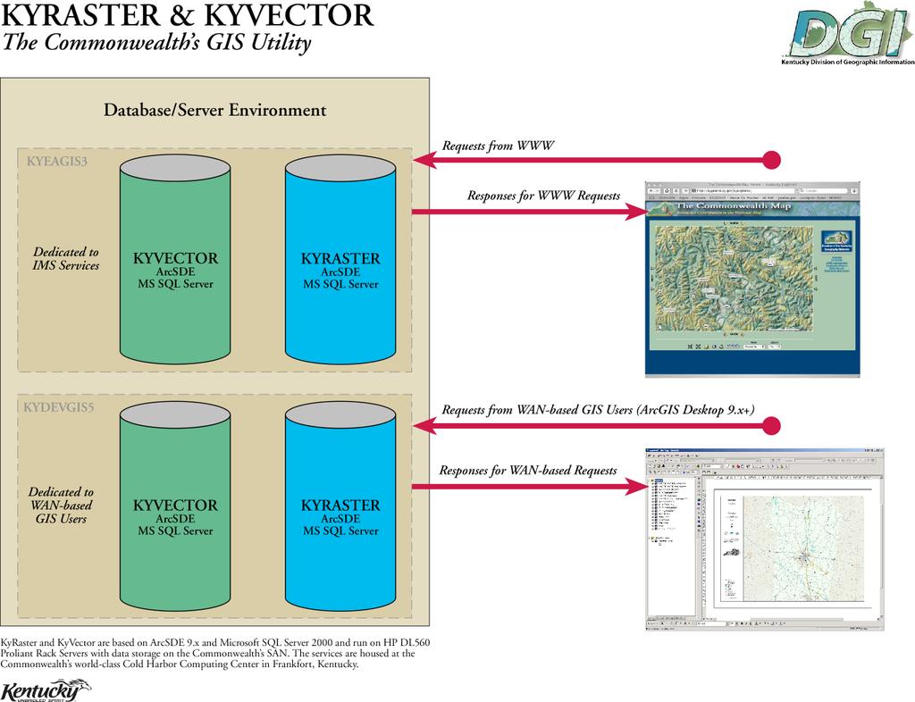
8 Kentucky Geo-Architecture
 and")
9 Centralized KYGEONET Facts KYGEONET has 487 Published Items! KYGEONET and associated state web sites received 7.5 million hits a month from over 32,000 Unique Visitors! This resource is maintained by over a dozen Responsible Publishers Over 25 Layers Published to the National Map Full Integration with National Geospatial one Stop (GOS) and Geography Network


10 KyGeonet Portal Offers Search & Display Place Name Type Theme Keyword
 Georeferenced image files (ortho imagery, aerial etc.")
11 Geospatial Data Formats Requiring ESRI GIS Software to Read SDE and File Geo Databases Shape Files sets of configured output data that can be reconfigured for research (usually combines easily read image, XML, and spreadsheet data) Georeferenced image files (ortho imagery, aerial etc.) Static formats not requiring GIS software to read GeoPDF or PDF Image files (JPEG and TIF) including scanned maps

12 Dataflow for Kentucky s Archival System
 Utah 339 Biota")
 Biota (wildlife) 1 (16)")
 41 Boundaries 30")
13 Layers per State and Sample ISO Categories State - Layers Central (local) Utah 339 Biota (wildlife) 29 Boundaries 24 Transportation 17 North Carolina 40 (2047) Biota (wildlife) 1 (16) Boundaries 4 (410) Transportation 35 (203) Kentucky 286 Biota (wildlife) 41 Boundaries 30 Transportation 9

14 Appraisal of Dynamic Geospatial Data Traditional appraisal applied to images & databases Identifying & describing official record Setting retention Non-traditional factors in GIS records management Inventory of data by GIS category/theme and layer Point of capture selection Frequency of capture determined Determining format for preservation
15 Frequency of Capture of Layers for Long Term Retention? Layer names Month Quarter Annual State government (KYGEONET) All database layers 100% Images (when funds are obtained) Local government (small sample of those archiving) Address Points 44.4% 11.1% 27.8% Utilities (water/sewer lines) 33.3% 5.6% 27.8% Airports & Airfields 5.6% 5.6% 27.8% Railroad Lines 5.6% 0.0% 27.8% Schools (districts, locations) 11.1% 16.7% 27.8% Emergency/911 (police/ fire) 22.2% 11.1% 27.8% Hydrography/Watershed 0.0% 0.0% 22.2%
16 Records Retention Schedule The system is scheduled as a permanent record and all image files are saved permanently. Copies come to the archive even when they are still in the system. Selected vector (data) files which are either: vital for special backup procedures archival for periodic capture and transfer to archive Vector data from each contributing agency is evaluated in the context of all agency records and captured through periodic snapshots

17 Retention Schedule State GIS agency

18 Schedules for GIS Records Division of Geographic Information The centralized system fed by multiple agencies State agencies with GIS series not in KYGEONET University model schedule One general series that covers static and dynamic maps Kentucky Geological Survey separate General schedule for state agencies One general series that covers static and dynamic maps Local records One general series that covers static and dynamic maps whether for a county or for a consortium
19 Local Retention Schedule & Archiving Desire to control information as a revenue source Project created MOA where archived data sent to the state Consortiums contain private utility data Some counties rely on Area Development Districts to create maps for them Property Value Administrators (PVA) are paid by the state, but want to maintain local control of data Archiving is seldom uniform and may not contain full metadata


20 Geospatial Metadata within Database tures in the image caused by terrain relief and sensor orientation have been reduc cteristics of a photograph with the geometric qualities of a map ERSI ARCCatalog view of layers in a database

21 DSpace Entry for Static GIS Records

22 Archiving Projects that Document Activities - Disaster Response Analysis Winter Ice Storm Service outage Winter Ice Storm Service Outage


23 Archival Web Services as Access Tools Services with configurable public viewers that could be used to demonstrate change using archived files and/or allow downloading of archived files

24 Stewardship: Repository as Catalyst Repository Goal Identify and protect at-risk (emergency management and archival) data Explore technical and organizational challenges Project End Goal Data Producers: Improved temporal data practices and risk management Archives: More efficient means of acquiring and preserving data
25 Advantages and Challenges of Centralized State GIS Systems Advantages Easily capture the most important GIS layers at once Researchers can easily select and use appropriate layers from a single source if they have access to ERSI software Access tools can to be constructed to show uniform views over time based on the web service configuration Records schedule is relatively simple and scheduled by agency Challenges Files that are locally controlled have to be appraised and accessioned separately or stored locally Technical meta data of archived files stays within the geospatial files not in the archival system The record is defined by the way the archived files (databases) are displayed to the public not as separate outputs
Geoarchiving Kentucky State Government Data. Glen McAninch Kentucky Department for Libraries and Archives
 Geoarchiving Kentucky State Government Data Glen McAninch (glen.mcaninch@ky.gov) Kentucky Department for Libraries and Archives KY GIS Day University of Kentucky November 17 th, 2011 GeoMAPP Project Overview
GeoMAPP: Using Metadata to Help Preserve Geospatial Content
 GeoMAPP: Using Metadata to Help Preserve Geospatial Content Matt Peters, Utah s Automated Geographic Reference Center Glen McAninch, Kentucky Department for Libraries and Archives Alec Bethune, North Carolina
Megan Durden, North Carolina State Archives Butch Lazorchak, Library of Congress Mark Myers, Kentucky State Archives Best Practices Exchange, Helena,
 GIS are from Mars, Archivists are from Venus: Linking State Government Geospatial Professionals and their Cultural l Heritage Counterparts Megan Durden, North Carolina State Archives Butch Lazorchak, Library
Moving from Keeping Stuff to Geoarchiving: Developing Dynamic Geospatial Data Archives
 Moving from Keeping Stuff to Geoarchiving: Developing Dynamic Geospatial Data Archives Alec Bethune- NC Center for Geographic Information and Analysis Kelly Eubank- North Carolina State Archives North
1. Which agency in your state is PRIMARILY responsible for archiving geospatial data and managing archived geo records? (choose one) nmlkj.
 nmlkj.") Survey Intro Kentucky, North Carolina, and Utah are partnering with the Library of Congress as part of the National Digital Information Infrastructure and Preservation Program (NDIIPP) to examine the current
Survey Intro Kentucky, North Carolina, and Utah are partnering with the Library of Congress as part of the National Digital Information Infrastructure and Preservation Program (NDIIPP) to examine the current
Geospatial Preservation: State of the Landscape. A Quick Overview. Steve Morris NCSU Libraries
 Geospatial Preservation: State of the Landscape A Quick Overview Steve Morris NCSU Libraries SAA 2011 August 26, 2011 14 Brief Overview of the Problem 15 Variety of Geospatial Data Types Variety of producers
NC Geospatial Data Archiving Project
 NC Geospatial Data Archiving Project 1. Frequency of Capture of Geospatial Data We seek your advice and experience in creating geospatial data snapshots for your archives -- versions of vector data and
Managing and Preserving Geospatial Records. Jennifer O Neill Scheduling and State Agency Services Supervisor October 2017
 Managing and Preserving Geospatial Records Jennifer O Neill Scheduling and State Agency Services Supervisor October 2017 Agenda Identify records retention period Organize and label files well Use widely
Safe to Save? Archive Options for Geodatabases. Jeff Essic North Carolina State University Libraries
 Safe to Save? Archive Options for Geodatabases Jeff Essic North Carolina State University Libraries 2011 ESRI International Users Conference July 13, 2011 GeoMAPP Geospatial Multistate Archive and Preservation
Spatial Data Availability Energizes Florida s Citizens
 NASCIO 2016 Recognition Awards Nomination Spatial Data Availability Energizes Florida s Citizens State of Florida Agency for State Technology & Department of Environmental Protection Category: ICT Innovations
Data Origin. Ron van Lammeren CGI-GIRS 0910
 Data Origin Ron van Lammeren CGI-GIRS 0910 How to obtain geodata? Geo data initiative Executive Order 12906, "Coordinating Geographic Data Acquisition and Access: The National Spatial Data Infrastructure,"
STATE GEOGRAPHIC INFORMATION DATABASE
 STATE GEOGRAPHIC INFORMATION DATABASE Data Information and Knowledge Management STATE GEOGRAPHIC INFORMATION DATABASE EXECUTIVE SUMMARY Utah has developed one of the most comprehensive statewide GIS resources
Data Origin. How to obtain geodata? Ron van Lammeren CGI-GIRS 0910
 Data Origin How to obtain geodata? Ron van Lammeren CGI-GIRS 0910 Spatial Data interest Improvement of policy making. ± 90% of all information used by government has spatial characteristics SPATIAL INFORMATION
Information. Information Technology. Geographic. Services (GIS) 119 W Indiana Ave Deland, FL 32720
 119 W Indiana Ave Deland, FL 32720") Information Technology Geographic Information Services (GIS) 119 W Indiana Ave Deland, FL 32720 A GIS consists of 5 primary components: Hardware Software People Data Methods or Business Processes --- Hardware
Information Technology Geographic Information Services (GIS) 119 W Indiana Ave Deland, FL 32720 A GIS consists of 5 primary components: Hardware Software People Data Methods or Business Processes --- Hardware
Large Scale Mapping Policy for the Province of Nova Scotia
 Large Scale Mapping Policy for the Province of Nova Scotia December, 2005 Version 1.0 TABLE OF CONTENTS PAGE BACKGROUND...3 POLICY...5 Policy 1.0 Large Scale Mapping Program...5 Policy 2.0 Service Offering...5
INSPIREd solutions for Air Quality problems Alexander Kotsev
 INSPIREd solutions for Air Quality problems Alexander Kotsev www.jrc.ec.europa.eu Serving society Stimulating innovation Supporting legislation The European data puzzle The European data puzzle 24 official
The Indiana Data Sharing Initiative and the IndianaMap. Cross-Boundary Collaboration and Partnerships. State of Indiana
 The Indiana Data Sharing Initiative and the IndianaMap Cross-Boundary Collaboration and Partnerships State of Indiana Brian Arrowood, CIO James Sparks, GIO EXECUTIVE SUMMARY Under the collaboration oriented
UTAH S STATEWIDE GEOGRAPHIC INFORMATION DATABASE
 UTAH S STATEWIDE GEOGRAPHIC INFORMATION DATABASE Data Information and Knowledge Management NASCIO Awards 2009 STATE GEOGRAPHIC INFORMATION DATABASE B. EXECUTIVE SUMMARY Utah has developed one of the most
ArcGIS Enterprise: What s New. Philip Heede Shannon Kalisky Melanie Summers Sam Williamson
 ArcGIS Enterprise: What s New Philip Heede Shannon Kalisky Melanie Summers Sam Williamson ArcGIS Enterprise is the new name for ArcGIS for Server What is ArcGIS Enterprise ArcGIS Enterprise is powerful
Spatial Data Infrastructure Concepts and Components. Douglas Nebert U.S. Federal Geographic Data Committee Secretariat
 Spatial Data Infrastructure Concepts and Components Douglas Nebert U.S. Federal Geographic Data Committee Secretariat August 2009 What is a Spatial Data Infrastructure (SDI)? The SDI provides a basis for
Exploring GIS Potential for Northwestern Ontario Land Information Ontario
 Exploring GIS Potential for Northwestern Ontario Land Information Ontario May 13, 2015 The LIO Vision LIO Vision: That all geographic information about Ontario is fully integrated and accessible LIO Goal:
USEPA's Comprehensive Geospatial Information Sharing Framework
 USEPA's Comprehensive Geospatial Information Sharing Framework An Overview ESRI Federal User Conference February 22, 2008 Agenda Background What is EPA s Geospatial Information Sharing Framework? Why was
U.S. Army Topographic Engineering Center (TEC) Alexandria, VA. Army Geo-Referenced PDF (GeoPDF) Project
 Alexandria, VA. Army Geo-Referenced PDF (GeoPDF) Project") U.S. Army Topographic Engineering Center (TEC) Alexandria, VA Army Geo-Referenced PDF (GeoPDF) Project June 2006 Ray Caputo Geospatial Information and Imagery Requirements Branch Operations Division The
U.S. Army Topographic Engineering Center (TEC) Alexandria, VA Army Geo-Referenced PDF (GeoPDF) Project June 2006 Ray Caputo Geospatial Information and Imagery Requirements Branch Operations Division The
GIS-T 2010 Building a Successful Geospatial Data Sharing Framework: A Ohio DOT Success Story
 GIS-T 2010 Building a Successful Geospatial Data Sharing Framework: A Ohio DOT Success Story ODOT District 2 GIS John Puente District 1 GIS Coordinator\ Planning Administrator 2 Interoperability 3 District
GEOGRAPHIC INFORMATION SYSTEMS Session 8
 GEOGRAPHIC INFORMATION SYSTEMS Session 8 Introduction Geography underpins all activities associated with a census Census geography is essential to plan and manage fieldwork as well as to report results
Geographical Collections in Greek Academic Libraries: current situation and perspectives
 Ionian University Department of Archives and Library Science Laboratory on Digital Libraries and Electronic Publishing Geographical Collections in Greek Academic Libraries: current situation and perspectives
Imagery and the Location-enabled Platform in State and Local Government
 Imagery and the Location-enabled Platform in State and Local Government Fred Limp, Director, CAST Jim Farley, Vice President, Leica Geosystems Oracle Spatial Users Group Denver, March 10, 2005 TM TM Discussion
OGC GEOPACKAGE AND HOW OPEN SOURCE IS CHANGING THE WAY GOVERNMENTS THINK ABOUT STANDARDS. Nathan Frantz Geospatial Research Lab
 OGC GEOPACKAGE AND HOW OPEN SOURCE IS CHANGING THE WAY GOVERNMENTS THINK ABOUT STANDARDS Nathan Frantz Geospatial Research Lab Dr. Ben Tuttle National Geospatial-Intelligence Agency FOSS4G 2015 Geospatial
Geospatial natural disaster management
 Geospatial natural disaster management disasters happen. are you ready? Natural disasters can strike almost anywhere at any time, with no regard to a municipality s financial resources. These extraordinarily
GIS at UCAR. The evolution of NCAR s GIS Initiative. Olga Wilhelmi ESIG-NCAR Unidata Workshop 24 June, 2003
 GIS at UCAR The evolution of NCAR s GIS Initiative Olga Wilhelmi ESIG-NCAR Unidata Workshop 24 June, 2003 Why GIS? z z z z More questions about various climatological, meteorological, hydrological and
CHAPTER 22 GEOGRAPHIC INFORMATION SYSTEMS
 CHAPTER 22 GEOGRAPHIC INFORMATION SYSTEMS PURPOSE: This chapter establishes the administration and use of to improve the quality and accessibility of Department s spatial information and support graphical
Report from the Geographic Information Coordinating Council
 Report from the Geographic Information Coordinating Council Presented by: Dr. Lee Mandell, Chair North Carolina Geographic Information Coordinating Council What is GIS? Geography plays a role in nearly
Internet GIS Sites. 2 OakMapper webgis Application
 Internet GIS Sites # Name URL Description 1 City of Sugar Land http://www.sugarlandtx.gov/index.htm It is a city in Texas with 65,000 Residents. The City of Sugar Land, Texas, provides ArcIMS-based maps
Kentucky s Geography Network
 Title of Nomination: Kentucky's Geography Network: "Sharing GIS data with the People" Project/System Manager: Kent Anness Title: GIS Manager Agency: Kentucky Infrastructure Authority Department: Address:
Nomination Form. Clearinghouse. New York State Office for Technology. Address: State Capitol-ESP, PO Box
 NASIRE 2001 RECOGNITION AWARDS Recognizing Outstanding Achievement in the Field of Innovative Use of Technology Nomination Form Title of Nomination: Manager/Job Title: Agency: NYS Geographic Information
The 3D Elevation Program: Overview. Jason Stoker USGS National Geospatial Program ESRI 2015 UC
 + The 3D Elevation Program: Overview Jason Stoker USGS National Geospatial Program ESRI 2015 UC + 2 A little history USGS has a long, proud tradition of mapmaking (2009) + 3 The changing times Mapping
GIS Visualization: A Library s Pursuit Towards Creative and Innovative Research
 GIS Visualization: A Library s Pursuit Towards Creative and Innovative Research Justin B. Sorensen J. Willard Marriott Library University of Utah justin.sorensen@utah.edu Abstract As emerging technologies
Digital Weft. InterPARES as common thread in Vancouver s Digital Preservation Programme. CITRA Oslo Sept 15, 2010
 Digital Weft InterPARES as common thread in Vancouver s Digital Preservation Programme CITRA Oslo Sept 15, 2010 Presentation Structure Context and Background City of Vancouver Archives and Records Programmes
Finding Common Ground Through GIS
 Finding Common Ground Through GIS Matthew Stone, MPH Special Unit for Technical Assistance Chronic Disease and Injury Control California Department of Public Health ESRI Health GIS Conference Scottsdale,
Modular Web Framework for the BRANDENBURGVIEWER
 Modular Web Framework for the BRANDENBURGVIEWER Geoinformation System (GIS) 2 GIS = geo + information + system + + Survey of data Organization of data Processing and Analysis Presentation geodata infrastructure
INSPIRE Basics. Vlado Cetl European Commission Joint Research Centre. https://ec.europa.eu/jrc/
 INSPIRE Basics Vlado Cetl European Commission Joint Research Centre https://ec.europa.eu/jrc/ Serving society Stimulating innovation Supporting legislation Outline SDI? Why European SDI? INSPIRE Policy
Manitoba s Elevation (LiDAR) & Imagery Datasets. Acquisition Plans & Opportunities for Collaboration
 & Imagery Datasets. Acquisition Plans & Opportunities for Collaboration") Manitoba s Elevation (LiDAR) & Imagery Datasets Acquisition Plans & Opportunities for Collaboration Manitoba Planning Conference May 2017 Presentation Outline Manitoba s Elevation (LiDAR) and Imagery Datasets
Manitoba s Elevation (LiDAR) & Imagery Datasets Acquisition Plans & Opportunities for Collaboration Manitoba Planning Conference May 2017 Presentation Outline Manitoba s Elevation (LiDAR) and Imagery Datasets
Building a national spatial data infrastructure. Thorben Hansen, Head of Division Danish Agency for Data Supply and Efficiency
 Building a national spatial data infrastructure Thorben Hansen, Head of Division Danish Agency for Data Supply and Efficiency About Spatial Data Infrastructure Spatial data come from many sources and is
Utah UIC Geospatial Integration EIEN Project
 Utah UIC Geospatial Integration EIEN Project ESRI UC, June 2007 Bert Granberg Utah Automated Geographic Reference Center Utah Automated Geographic Reference Center (AGRC) AGRC Responsibilities Facilitate
Norwegian spatial data infrastructure supporting disaster risk management Norwegian Mapping Authority
 Norwegian spatial data infrastructure supporting disaster risk management Norwegian Mapping Authority Arvid Lillethun, Norwegian Mapping Authority Land and Poverty 2018 Conference, World Bank 19.-23. March
Regional EGM on Community of Practice of Georeferenced Information System. for Disaster Risk Management (Geo-DRM) April 2014, Bangkok, Thailand
 April 2014, Bangkok, Thailand") Regional EGM on Community of Practice of Georeferenced Information System for Disaster Risk Management (Geo-DRM) 23-25 April 2014, Bangkok, Thailand Presented By Mukesh Kumar Keshari Ministry of Home Affairs
Regional EGM on Community of Practice of Georeferenced Information System for Disaster Risk Management (Geo-DRM) 23-25 April 2014, Bangkok, Thailand Presented By Mukesh Kumar Keshari Ministry of Home Affairs
Brian D. George. GIMS Specialist Ohio Coastal Atlas Project Coordinator and Cartographer. Impacts and Outcomes of Mature Coastal Web Atlases
 Ohio Coastal Atlas Project Brian D. George GIMS Specialist Ohio Coastal Atlas Project Coordinator and Cartographer Ohio Department of Natural Resources Office of Coastal Management Sandusky, OH Impacts
GEOGRAPHIC INFORMATION SYSTEMS
 GEOGRAPHIC INFORMATION SYSTEMS 4-H Round-Up Community Transitions Workshop Daniel Hanselka June 14, 2011 Goals of the Workshop Answer the question: What is GIS? Uses of GIS. Some of the Common Terminology
Brazil Paper for the. Second Preparatory Meeting of the Proposed United Nations Committee of Experts on Global Geographic Information Management
 Brazil Paper for the Second Preparatory Meeting of the Proposed United Nations Committee of Experts on Global Geographic Information Management on Data Integration Introduction The quick development of
Charter for the. Information Transfer and Services Architecture Focus Group
 for the Information Transfer and Services Architecture Focus Group 1. PURPOSE 1.1. The purpose of this charter is to establish the Information Transfer and Services Architecture Focus Group (ITSAFG) as
5A.10 A GEOSPATIAL DATABASE AND CLIMATOLOGY OF SEVERE WEATHER DATA
 5A.10 A GEOSPATIAL DATABASE AND CLIMATOLOGY OF SEVERE WEATHER DATA Steve Ansari * and Stephen Del Greco NOAA National Climatic Data Center, Asheville, North Carolina Mark Phillips University of North Carolina
Title: Storm of the Century: Documenting the 1993 Superstorm
 A. PAIIF 2011 Cover Page Title: Storm of the Century: Documenting the 1993 Superstorm Point of Contact: Name: Alex Granger Email: alex.granger@noaa.gov Phone Number: 571-555-9278 Mailing Address: Research
Pushing the Standards Edge: Collaborative Testbeds to Accelerate Standards Development and Implementation
 Pushing the Standards Edge: Collaborative Testbeds to Accelerate Standards Development and Implementation Mark E. Reichardt President mreichardt@opengeospatial.org 31 October 2006 2006 Open Geospatial
DEPARTMENT OF GEOLOGY AND MINERAL INDUSTRIES WAYS & MEANS SUBCOMMITTEE ON NATURAL RESOURCES MARCH 2, 2017
 DEPARTMENT OF GEOLOGY AND MINERAL INDUSTRIES WAYS & MEANS SUBCOMMITTEE ON NATURAL RESOURCES MARCH 2, 2017 1 ABOUT DOGAMI AGENCY MISSION, VISION & GOALS 2 Lidar image of a stream network along the Umpqua
SUPPORTS SUSTAINABLE GROWTH
 DDSS BBUUN NDDLLEE G E O S P AT I A L G O V E R N A N C E P A C K A G E SUPPORTS SUSTAINABLE GROWTH www.digitalglobe.com BRISBANE, AUSTRALIA WORLDVIEW-3 30 CM International Civil Government Programs US
The Use of Geographic Information Systems (GIS) by Local Governments. Giving municipal decision-makers the power to make better decisions
 by Local Governments. Giving municipal decision-makers the power to make better decisions") The Use of Geographic Information Systems (GIS) by Local Governments Giving municipal decision-makers the power to make better decisions Case Study: Examples of GIS Usage by Local Governments in North
The Use of Geographic Information Systems (GIS) by Local Governments Giving municipal decision-makers the power to make better decisions Case Study: Examples of GIS Usage by Local Governments in North
Introduction. Elevation Data Strategy. Status and Next Steps
 1 2 Introduction Elevation Data Strategy Status and Next Steps 3 Canada is the 2nd largest country in the world - 9.9 million sq km Surrounded by 3 oceans with 202 000 km of coastline Population over 35
Standards in Action: The Canadian Geospatial Data Infrastructure (CGDI)
") Standards in Action: The Canadian Geospatial Data Infrastructure (CGDI) Craig Stewart ISO/TC211 Standards in Action Workshop, September 14, 2005 Presentation Outline Overview of SDIs Overview of Canada
Standards in Action: The Canadian Geospatial Data Infrastructure (CGDI) Craig Stewart ISO/TC211 Standards in Action Workshop, September 14, 2005 Presentation Outline Overview of SDIs Overview of Canada
THE SPATIAL DATA WAREHOUSE OF SEOUL
 THE SPATIAL DATA WAREHOUSE OF SEOUL Jae-Ho Han The Seoul Metropolitan Government Seoul City Hall, Taepyeongno 1(il)-ga, Jung-gu, Seoul 100-744, Korea djhjha@hanmail.net Impyeong Lee Dept. of Geoinformatics,
GIS Resources for Local Governments
 ISSUE PAPER SERIES GIS Resources for Local Governments February 2018 NEW YORK STATE TUG HILL COMMISSION DULLES STATE OFFICE BUILDING 317 WASHINGTON STREET WATERTOWN, NY 13601 (315) 785-2380 WWW.TUGHILL.ORG
The Process of Spatial Data Harmonization in Italy. Geom. Paola Ronzino
 The Process of Spatial Data Harmonization in Italy Geom. Paola Ronzino ISSUES Geospatial Information in Europe: lack of data harmonization the lack of data duplication of data CHALLENGES Challenge of INSPIRE:
Establishing the National Spatial Data Infrastructure (NSDI) for Norway a joint effort by many stakeholders SPATIAL DATA FOR BENEFIT OF THE SOCIETY
 for Norway a joint effort by many stakeholders SPATIAL DATA FOR BENEFIT OF THE SOCIETY") Establishing the National Spatial Data Infrastructure (NSDI) for Norway a joint effort by many stakeholders SPATIAL DATA FOR THE BENEFIT OF SOCIETY OUTLINE Political background Norway digital - The Norwegian
Establishing the National Spatial Data Infrastructure (NSDI) for Norway a joint effort by many stakeholders SPATIAL DATA FOR THE BENEFIT OF SOCIETY OUTLINE Political background Norway digital - The Norwegian
ArcGIS is Advancing. Both Contributing and Integrating many new Innovations. IoT. Smart Mapping. Smart Devices Advanced Analytics
 ArcGIS is Advancing IoT Smart Devices Advanced Analytics Smart Mapping Real-Time Faster Computing Web Services Crowdsourcing Sensor Networks Both Contributing and Integrating many new Innovations ArcGIS
Geospatial SDI Portal for effective Governance of Pune METROPOLIS region
 Geospatial SDI Portal for effective Governance of Pune METROPOLIS region Mr. Praveen Gautam Senior Manager 19 th January 2018 PMRDA Overview Provide a Spatial Framework for the entire region with various
Technical Specifications. Form of the standard
 Used by popular acceptance Voluntary Implementation Mandatory Legally enforced Technical Specifications Conventions Guidelines Form of the standard Restrictive Information System Structures Contents Values
ArcGIS Enterprise: What s New. Philip Heede Shannon Kalisky Melanie Summers Shreyas Shinde
 ArcGIS Enterprise: What s New Philip Heede Shannon Kalisky Melanie Summers Shreyas Shinde ArcGIS Enterprise is the new name for ArcGIS for Server ArcGIS Enterprise Software Components ArcGIS Server Portal
Coastal Response Research Center. Nancy Kinner University of New Hampshire (UNH) Michele Jacobi NOAA ORR. September 27, 2007
 Michele Jacobi NOAA ORR. September 27, 2007") Coastal Response Research Center Nancy Kinner University of New Hampshire (UNH) Michele Jacobi NOAA ORR September 27, 2007 1 Coastal Response Research Center (CRRC) CRRC is partnership between NOAA s Office
Coastal Response Research Center Nancy Kinner University of New Hampshire (UNH) Michele Jacobi NOAA ORR September 27, 2007 1 Coastal Response Research Center (CRRC) CRRC is partnership between NOAA s Office
State Geographic Information Consolidation Implementation Plan
 State Geographic Information Consolidation Implementation Plan As Directed by Session Law 2008-0107 Section 6.13 Prepared By: State Chief Information Officer Geographic Information Coordinating Council
NOKIS - Information Infrastructure for the North and Baltic Sea
 NOKIS - Information Infrastructure for the North and Baltic Sea Carsten Heidmann 1 and Jörn Kohlus 2 Abstract 1. General The initial motivation for the project NOKIS (German title: Nord- und Ostsee-Küsteninformationssystem)
OC Enterprise GIS. Kevin Hills, PLS Cameron Smith, GISP. OC Survey
 OC Enterprise GIS Kevin Hills, PLS Cameron Smith, GISP OC Survey Discussion Points Background & Organizational Structure of OCPW Past practices prior to Enterprise Wide GIS License (ELA) Participating
GIS for Integrated Pest Management. Christina Hailey. Abstract:
 GIS for Integrated Pest Management Christina Hailey Abstract: At its formation in 1965, Harris County Mosquito Control (Houston, Texas) (HCMC) was primarily involved in the prevention and control of mosquito-borne
Overview. Project Background Project Approach: Content and Application Development Application Demonstration Future Developments
 Overview Project Background Project Approach: Content and Application Development Application Demonstration Future Developments Southeast Pressures: Continued Population Growth Transportation Corridors
Digital Wetlands. Bringing the Field into the Office Through GIS
 Digital Wetlands Bringing the Field into the Office Through GIS Maryland Department of the Environment Wetlands and Waterways Program MDE's Wetlands and Waterways Program seeks to conserve valuable aquatic
NDIIPP: The National Digital Information Infrastructure and Preservation Program
 NDIIPP: The National Digital Information Infrastructure and Preservation Program Julie Sweetkind-Singer Head, Branner Earth Sciences Library & Map Collections, Stanford University GIS & Map Librarian The
2013 NASCIO Award Submission Category: Cross-Boundary Collaboration and Partnerships. Project Title: Public Safety and Enterprise GIS in Tennessee
 2013 NASCIO Award Submission Category: Cross-Boundary Collaboration and Partnerships Project Title: Public Safety and Enterprise GIS in Tennessee State of Tennessee, Board of Parole State of Tennessee,
Keeping Maps Safe and Accessible: Digitization and Preservation at the Library of Congress
 Keeping Maps Safe and Accessible: Digitization and Preservation at the Library of Congress September 27, 2017 p.1 Agenda Jacqueline Nolan, Cartographer Colleen Cahill, Digital Conversion Coordinator Geography
DP Project Development Pvt. Ltd.
 Dear Sir/Madam, Greetings!!! Thanks for contacting DP Project Development for your training requirement. DP Project Development is leading professional training provider in GIS technologies and GIS application
The 2020 Census Geographic Partnership Opportunities
 The 2020 Census Geographic Partnership Opportunities Web Adams Geographer, U.S. Census Bureau New York Regional Office 1 Geographic Partnership Opportunities The 2020 Census Local Update of Census Addresses
GIS and Community Health. GIS and Community Health. Institutional Context and Interests in GIS Development. GIS and Community Health
 GIS and Community Health GIS and Community Health Some critiques of GIS emphasize the potentially harmful social consequences of the diffusion of GIS technology, including reinforcing the power of state
Portals: Standards in Action
 Portals: Standards in Action David Danko ISO TC 211 Metadata Project Leader GIS Standards Consultant-ESRI. Metadata Portals Portal gateway, place of entry Producers Advertise, expose products Share information
Navigating to Success: Finding Your Way Through the Challenges of Map Digitization
 Library Faculty Presentations Library Faculty/Staff Scholarship & Research 10-15-2011 Navigating to Success: Finding Your Way Through the Challenges of Map Digitization Cory K. Lampert University of Nevada,
Phase One Development of a Comprehensive GIS for the Mentor Marsh and its Proximal Watershed
 FINAL REPORT Phase One Development of a Comprehensive GIS for the Mentor Marsh and its Proximal Watershed Lake Erie Protection Fund SG 120-99 Ohio State University Research Foundation RF 738027 December
Innovation. The Push and Pull at ESRI. September Kevin Daugherty Cadastral/Land Records Industry Solutions Manager
 Innovation The Push and Pull at ESRI September 2004 Kevin Daugherty Cadastral/Land Records Industry Solutions Manager The Push and The Pull The Push is the information technology that drives research and
NOAA Surface Weather Program
 NOAA Surface Weather Program Maintenance Decision Support System Stakeholder Meeting #9 Jim O Sullivan NOAA Surface Weather Program Manager NWS Office of Climate, Water, and Weather Services September
An Alternate Career Choice for the Geography Major: Map, GIS, or Geographic Information Librarianship
 An Alternate Career Choice for the Geography Major: Map, GIS, or Geographic Information Librarianship Katherine H. Weimer Texas A&M University Libraries SWAAG 2007 - Bryan, Texas Overview of today s talk
GIS Building Communities beyond National Borders (Building Successful Spatial Data Infrastructures) Nick Land, ESRI Europe
 Nick Land, ESRI Europe") GIS Building Communities beyond National Borders (Building Successful Spatial Data Infrastructures) Nick Land, ESRI Europe UK worst flooding in the last 60 years 350,000 households without drinking water
GIS Building Communities beyond National Borders (Building Successful Spatial Data Infrastructures) Nick Land, ESRI Europe UK worst flooding in the last 60 years 350,000 households without drinking water
Open Data meets Big Data
 Open Data meets Big Data Max Craglia, Sven Schade, Anders Friis European Commission Joint Research Centre www.jrc.ec.europa.eu Serving society Stimulating innovation Supporting legislation JRC is Technical
Using MAGIC to Access Spatial Imagery: Putting ER Mapper Image Web Server, ArcIMS and MrSID to work in your Library
 Using MAGIC to Access Spatial Imagery: Putting ER Mapper Image Web Server, ArcIMS and MrSID to work in your Library Patrick McGlamery Shirley Quintero University of Connecticut Libraries Building the Connecticut
Office of Technology Partnerships GIS Collaboration
 Office of Technology Partnerships GIS Collaboration State GIS Update April 21, 2017 Mark Holmes, GISP Outline MGF Upgrade Project Census Programs Imagery Update LiDAR Update Open Discussion 2 MGF Background
To: Ross Martin, Lisa Stapleton From: Brad Lind Subject: Joint Funding Agreement with USGS for 2012 Imagery Date: March 14, 2012.
 To: Ross Martin, Lisa Stapleton From: Brad Lind Subject: Joint Funding Agreement with USGS for 2012 Imagery Date: March 14, 2012 Attached are two copies of the Joint Funding Agreement (JFA) between SanGIS
Enhancing Parcel Data In Colleton County. February 10, 2009
 Enhancing Parcel Data In Colleton County GIS & CAMA Conference February 10, 2009 Introductions Bruce T. Harper Technology Director Colleton County, SC Bill Wetzel National GIS Account Manager The Sidwell
Overview of Geospatial Open Source Software which is Robust, Feature Rich and Standards Compliant
 Overview of Geospatial Open Source Software which is Robust, Feature Rich and Standards Compliant Cameron SHORTER, Australia Key words: Open Source Geospatial Foundation, OSGeo, Open Standards, Open Geospatial
Exploit your geodata to enable smart cities and countries
 Exploit your geodata to enable smart cities and countries Carsten Rönsdorf, Head of Advisory Services Middle East Practice Manager Future Cities, standards and 3D 24 November 2014 Importance of Standards
Demonstration of a local SDI solution with several stakeholders in pilot areas in line with EU best practices
 EU Twinning project for the Agency of Land Relations and Cadaster (ALRC)- Organization, Streamlining and Computerization Process in Mapping in the Republic of Moldova. Demonstration of a local SDI solution
Open spatial data infrastructure
 Open spatial data infrastructure a backbone for digital government Thorben Hansen Geomatikkdagene 2018 Stavanger 13.-15. mars Spatial Data Infrastructure definition the technology, policies, standards,
Reducing Complex Spatial Data Management Needs in and Upstream Oil and Gas Operations Team. Jason Wilson GIS Business Analyst SM Energy
 Reducing Complex Spatial Data Management Needs in and Upstream Oil and Gas Operations Team Jason Wilson GIS Business Analyst SM Energy Agenda About Myself and SM Energy The Challenge The Goal Solution
A New National Flood Inundation Mapping Science Initiative
 A New National Flood Inundation Mapping Science Initiative William Guertal, PhD. Director, USGS Indiana and Kentucky Water Science Centers U.S. Department of the Interior U.S. Geological Survey Courtesy
Who has the data? Results of Maryland s 3-Week Statewide GIS Inventory Challenge. This is your state. This is your inventory.
 Who has the data? Results of Maryland s 3-Week Statewide GIS Inventory Challenge This is your state. This is your inventory. Maryland s Need for GIS Inventory Maryland had no central repository for its
A Global Approach to Building a GIS Strategy Esri UC July 15th, 2014
 Scott Sitzman and Paloma Urbano A Global Approach to Building a GIS Strategy Esri UC July 15th, 2014 1 METHODOLOGY 2 GIS Strategy Study Methodology Maturity Model by Carnegie Mellon Current State Review
Experiences and Directions in National Portals"
 FIG Seminar on e-land Administration Innsbruck/Austria 2-4 June 2004 "ESRI's Experiences and Directions in National Portals" Kevin Daugherty Cadastral/Land Records Manager ESRI Topic Points Technology