Restoration Goals TFG Meeting. Agenda
|
|
|
- Kelly Stewart
- 5 years ago
- Views:
Transcription
 Interim Flows b) EIS/EIR 4.")
 Analytical Tools for Alts.")
1 San Joaquin River Restoration Program Restoration Goals TFG Meeting Reach 2B Update April 28, 2010 Agenda 1. Introductions 2. Program Restoration Goal Context 3. Program Update a) Interim Flows b) EIS/EIR 4. Mendota Pool Bypass/Reach 2B Project a) Existing Conditions Review b) Schedule & Upcoming Milestones c) Initial Options i. Objective and Focus Explanation ii. Floodplain Options iii. Pool Bypass Options iv. Pool Bifurcation Structure Options d) Analytical Tools for Alts. Evaluation i. Objective and Focus Explanation ii. Fisheries iii. Geomorphology iv. Groundwater Draft. For Discussion Purposes Only. 1
2 Program Restoration Goal Context Settlement Restoration Goal Restore and maintain fish populations in good condition in the main stem San Joaquin River below Friant Dam to the confluence of the Merced River, including naturally-reproducing and self-sustaining populations of salmon and other fish Foundation of all of the site-specific projects Focus is currently on spring-run and fall-run Chinook salmon and Central Valley steelhead Likely surrogates for other native species Each site-specific project contributes to meeting the fundamental life-history needs of these species Program Update Program EIS/R Draft PEIS/R under preparation Public Release targeted for June day comment period Public hearings (dates/locations to be determined) Final PEIS/R Late 2010 Record of Decision i Early 2011 Check the website at for updates. Draft. For Discussion Purposes Only. 2
3 Program Update Interim Flows Flow Rate (cfs) Gravelly Ford Flows (cfs) Friant Dam Releases (cfs) Sack Dam Flows (cfs) Feb. 1 Mar. 1 Apr. 1 May. 1 Reach 2B Update Mendota Pool Bypass & Reach 2B Improvements a) Existing Conditions Review b) Schedule & Upcoming Milestones c) Initial Options i. Objective and Focus Explanation ii. Floodplain Options iii. Pool Bypass Options iv. Pool Bifurcation Structure Options d) Analytical Tools for Alts. Evaluation i. Objective and Focus Explanation ii. Fisheries iii. Geomorphology iv. Groundwater Draft. For Discussion Purposes Only. 3
 Upstream Chowchilla Bifurcation")

 Primarily dry")

4 Existing Conditions Review Existing Conditions Review 1. Project Extents (Phase 1 ) Upstream Chowchilla Bifurcation Structure D stream Bypass Connection 2. Ex. Structures Chowchilla Bifurcation San Mateo Crossing Mendota Dam Water Supply Infrastructure 3. Ex. Conditions Limited capacity (1,300 cfs 2,500 cfs) Primarily dry upstream Pool backup to San Mateo Ave. Shallow Groundwater 4. Settlement Req. Channel/Floodplain capacity up to 4,500 cfs Pool Bypass Floodplain & related riparian habitat Draft. For Discussion Purposes Only. 4
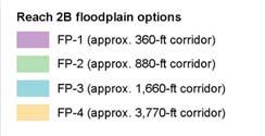
5 Schedule & Upcoming Milestones Initial Options TM complete Data Needs TM complete Field Surveys to start in May Refinement to Initial Alternatives ti ongoing Evaluation of Initial Alternatives projected for summer 2010 Alternatives Evaluation TM projected for fall 2010 Reach 2B Public Documents can be downloaded here: Initial Options Initial Options» Objective & Focus» Floodplain Options» Mendota Pool Bypass Options» Pool Bifurcation Structure Challenges Draft. For Discussion Purposes Only. 5


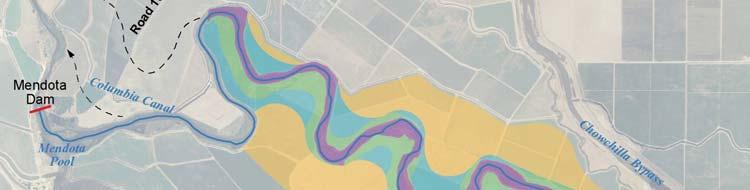

6 Initial Options - Focus Pool Bypass Options Pool Bifurcation Structure Initial Options - Floodplain Draft. For Discussion Purposes Only. 6


7 Initial Options - Floodplain Typical Floodplain Depth Typical Floodplain Depth Typical Floodplain Depth Initial Options Pool Bypass Draft. For Discussion Purposes Only. 7
 Screen overtopping issues % Survival through Pool Analytical Tools for Alts. Evaluation Analytical Tools for Alts.")
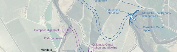
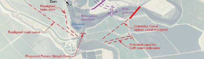
8 Initial Options Pool Bifurcation Structure Objectives: Convey 4,500 cfs to Bypass Ability to divert 2,500 cfs to Pool Direct fish to Bypass Minimize fish entrainment (screening) Challenges Flow split evaluation Screen design flow (% of capacity) Screen overtopping issues % Survival through Pool Analytical Tools for Alts. Evaluation Analytical Tools for Alts. Evaluation» Objective & Focus» Fish Passage and Habitat» Geomorphology» Groundwater Draft. For Discussion Purposes Only. 8


9 Analytical Tools for Alts. Evaluation Process Analytical Tools for Alts. Evaluation - Objective Analytical tools needed to evaluate the initial alternatives formulate a final set of alternatives, and evaluate those alternatives in the EIS/R Tools should assess: relative ability of the alternatives to meet the Project s purpose p and need, goals and objectives; the physical, economic, and environmental effects of the alternatives; and the fisheries impacts and benefits of each alternative Draft. For Discussion Purposes Only. 9
10 Analytical Tools for Alts. Evaluation Fish Passage and Habitat» Approach» Evaluation Criteria» Tools to Quantify Criteria Fish Passage and Habitat Approach Objectives: Address migration and habitat use goals of the Reach 2B Project Compare passage and habitat conditions between initial alternatives using specific criteria Evaluate initial alternatives based upon: Fish passage conditions Within San Joaquin River channel At artificial structures Mendota Pool Bypass drop structures t San Mateo Ave crossing Chowchilla and Mendota Pool bifurcation structures Rearing habitat conditions for spring- and fall-chinook, CV steelhead and other native fishes In-channel rearing habitat Floodplain rearing habitat Draft. For Discussion Purposes Only. 10
11 Fish Passage and Habitat Passage Evaluation Criteria In San Joaquin River channel Passage velocity: percent of range of flows meeting passage criteria Passage depth: length and width of channel meeting depth passage criteria Temperature: # of days of suitable water temperature At artificial structures Minimum fish passage requirements (NMFS 2008) Evaluate structure ability to meet jump, velocity, depth, and entrance and exit conditions Total number of structures fish must pass Fish Passage and Habitat Passage Criteria Thresholds Spring-run Chinook Salmon Life Stage Oct Nov Dec Jan Feb Mar Apr May Jun Jul Aug Sep Adult Migration D: 0.8 ft (min) V: 8 f/s (max) T: 64 F (max) Juvenile out migration D: ft (range) V: f/s (range) T: 64 F (max) Fall-run Chinook Salmon Life Stage Oct Nov Dec Jan Feb Mar Apr May Jun Jul Aug Sep Adult Migration D:08ft(min) 0.8 V: 8 f/s (max) T: 64 F (max) Juvenile outmigration D: ft (range) V: f/s (range) T: 64 F (max) Draft. For Discussion Purposes Only. 11
12 In-channel rearing Fish Passage and Habitat Rearing Habitat Evaluation Criteria Channel dimension: width and depth Habitat features: pools and bars Length of bordering riparian vegetation Floodplain rearing Depth: area within specified range Floodplain area: width per channel length Inundation duration and periodicity (# floods/yr) Potential for floodplain features: ponds, secondary channels, vegetation types Fish Passage and Habitat Rearing Habitat Evaluation In-channel rearing Physical habitat criteria from literature (depth, velocity, temperature) Qualitative evaluation of channel condition using literature description/values compared to expected habitat conditions Floodplain rearing Physical habitat criteria from literature (depth, velocity, temperature) Area of frequently activated floodplain Smallest flood pulse that initiates beneficial ecological processes (Williams et al. 2009) River stage that occurs 2/3 years, 7 day duration, mid-march to mid-may Qualitative evaluation based upon Area of potentially beneficial floodplain features Area of inundated riparian vegetation and vegetation types Draft. For Discussion Purposes Only. 12


13 Fish Passage and Habitat Example aquatic habitat features from 1937 aerial photograph, downstream end of Reach 2A Off Channel Pond Flood Plain Point Bar Riparian Vegetation Secondary Channel Sand Splay Pool Fish Passage and Habitat Analytical Tools for Criteria Quantification Tool Descriptions: HEC-RAS with daily flow data SRH1-DV: vegetation model HEC-5Q: Temperature model Geomorphic analyses Draft. For Discussion Purposes Only. 13
14 Fish passage: Fish Passage and Habitat Analytical Tools for Criteria Quantification In-channel HEC-RAS Flow depth and velocity at cross-sections Length of channel meeting depth and velocity criteria HEC-5Q: water temperature during migration Structures HEC-RAS Flow depth and velocity at structure NMFS (2008) criteria Ground surveys and literature review: # of structures along migration route Rearing habitat: In-channel Fish Passage and Habitat Analytical Tools for Criteria Quantification HEC-RAS: channel width and depth SRH-1DV: length of vegetated bank Geomorphic analyses: potential habitat Floodplain HEC-RAS and daily flow data: acreage by depth, inundation duration and periodicity it SRH-1DV: acreage of vegetation types LiDAR & Geomorph analyses: area of floodplain features Draft. For Discussion Purposes Only. 14
15 Fish Passage and Habitat Summary Criteria Metric Tools Passage conditions in the channel Length of proposed channel HEC-RAS Water temperature during migration Days meeting criteria during HEC-5Q migration periods Passage conditions at structures Jump height, velocity, depth of Fish passage criteria flow Number of artificial structures in migratory path In-channel habitat including riparian habitat Floodplain inundation depth, area, duration and periodicity Floodplain habitat based on floodplain features Number of structures in migratory path Pool: bars, average width and depth of active channel, average depth of flow, length of banks with woody riparian vegetation Floodplain acreage by depth range Floodplain inundation duration Floodplain inundation periodicity (average number of events per year, period between events) Acreage of different features Acreage of riparian types HEC-RAS, geomorphic analyses, SRH-1DV HEC-RAS, daily flow data, frequency duration curves SRH-1DV, geomorphic analyses SRH-1DV Analytical Tools for Alts. Evaluation Geomorphology» Approach» Evaluation Criteria» Tools to Quantify Criteria Draft. For Discussion Purposes Only. 15
16 Geomorphology General Approach What is the Expected Response of the River to Restoration Flows? How do the Initial Alternatives Interact with Expected River s Response? Refine the initial alternatives such that long-term channel stability is encouraged and the required habitat features are supported Geomorphology General Approach Application of Geomorphic Principles Application of Analytical Models Predict River s response to restoration flows. Evaluate Interaction of Initial Alternatives with Expected River Response Alternative Refinement Process Draft. For Discussion Purposes Only. 16
17 Geomorphology Approach Apply Geomorphic Principles Analog Historical aerials River s response to Interim flows Empirical Geomorphically significant flows and the most effective discharge Active channel width, equilibrium slope and depth Planform geometry Bed forms Predict the Expected Future Stable Channel Configuration Including range of variance Geomorphology Approach Perform Analytical Assessment Evaluate sediment continuity: Predict river s response to sediment load from Reach 2A Evaluate meander development and lateral migration tendencies Evaluate meander cutoff potential Evaluate erosion potential of outer banks at meander bend Evaluate Long-Term Stability Incorporates vegetation growth Draft. For Discussion Purposes Only. 17
18 Geomorphology Approach Predict River s response to Restoration Flows Combine results from geomorphic and analytical assessment Overlay initial alternatives With proposed structures Evaluate how the initial alternatives interact with the expected River s response Allow or inhibit geomorphic process Allow or inhibit fish habitat features Geomorphology Evaluation Criteria Potential to reach a stable channel configuration in dynamic equilibrium Potential to accommodate meander migration Potential for pool/bar formation Potential to develop floodplain topographic features Draft. For Discussion Purposes Only. 18
19 Geomorphology Analytical Tools for Criteria Quantification Geomorphic Tools Effective discharge Analog data Empirical relationships Analytical Tools HEC-RAS SRH-1D SRH-1DV Bank stability equations Geomorphology Summary Criteria Metric Tools Potential to reach a stable channel configuration in dynamic equilibrium Potential to accommodate meander migration Potential for pool/bar formation Potential to develop floodplain features Qualitative scale Flow duration curve from 1 to 10 HEC-RAS SRH-1D Geomorphic principals Bank stability indices Qualitative scale from 1 to 10 Qualitative scale from 1 to 10 Qualitative scale from 1 to 10 Flow duration curve HEC-RAS SRH-1D Geomorphic principals Bank stability indices Flow duration curve HEC-RAS SRH-1D Geomorphic principals Bank stability indices Geomorphic principals HEC-RAS Draft. For Discussion Purposes Only. 19
20 Analytical Tools for Alts. Evaluation Groundwater» Approach» Evaluation Criteria» Tools to Quantify Criteria Groundwater Approach & Evaluation Criteria Approach (Draft Seepage Management Plan 12/09) Issues Water logging of crops Draft thresholds in Seepage Mgmt Plan (depth to water that would impact crops) Reach 2B is losing reach Mendota Pool portion may have less seepage if pool is drained Root Zone Salinity (thresholds established, but doesn t require modeling) Levee Instability (design criteria) Mitigation: measures are identified in SMP for postconstruction problems Evaluation Criteria - Impacts Acres of waterlogging (indicator of root zone salinity) Draft. For Discussion Purposes Only. 20
 GW level data (monitoring wells) Well drilling")
 O HEC-RAS input/output Draft.")
21 Groundwater Analytical Tools Data/Tools to Support Alts Evaluation Preliminary USGS CVHM output (MODFLOW) HEC-RAS input/output Topography (LiDAR/Bathymetry) GW level data (monitoring wells) Well drilling lithologic and construction logs (USGS) Land Use Groundwater Summary Criteria Metric Tools Acres of Waterlogging acres Preliminary USGS CVHM output (MODFLOW) O HEC-RAS input/output Draft. For Discussion Purposes Only. 21
22 Wrap Up & Questions Draft. For Discussion Purposes Only. 22
Hydraulic and Sediment Transport Modeling Strategy
 Appendix B Hydraulic and Sediment Transport Modeling Strategy May 2014 Technical Memorandum Channel Capacity Report January 2015 San Joaquin River Restoration Program Hydraulic and Sediment Transport Modeling
SRH Group Facies Mapping
 Study 37 SRH Group Facies Mapping Public Draft 2014 Monitoring and Analysis Plan September 2013 Project Management Plan (PMP) Job Name: San Joaquin River Restoration Program Date Submitted: 8-1-13 Hydraulic
Folsom Dam Water Control Manual Update Joint Federal Project, Folsom Dam
 Folsom Dam Water Control Manual Update Joint Federal Project, Folsom Dam Public Workshop May 25, 2016 Sacramento Library Galleria 828 I Street, Sacramento, CA US Army Corps of Engineers BUILDING STRONG
DRAFT Geomorphic Analysis for the San Joaquin River Reach 2B Alternative Evaluation
 DRAFT Geomorphic Analysis for the San Joaquin River Reach 2B Alternative Evaluation April 25, 2011 A geomorphic analysis was performed by Tetra Tech, Inc., dba Mussetter Engineering (Tt-MEI) to assist
Influence of Paleochannels on Seepage
 Study 4 Influence of Paleochannels on Seepage Public Draft 2014 Monitoring and Analysis Plan September 2013 August 2012 Influence of Paleochannels on Seepage 1. Statement of Need Historical maps, aerial
60 PERCENT DESIGN REPORT HABITAT RESTORATION OF THE CHELAN RIVER REACH 4 AND TAILRACE
 60 PERCENT DESIGN REPORT HABITAT RESTORATION OF THE CHELAN RIVER REACH 4 AND TAILRACE Prepared for Public Utility District Number 1 of Chelan County 327 North Wenatchee Avenue Wenatchee, Washington 98801
Appendix G. Meso-Habitat Surveys. DRAFT Annual Technical Report
 Appendix G Meso-Habitat Surveys DRAFT Annual Technical Report Draft March 2010 1.0 Introduction 1 2 3 4 5 6 1.0 Introduction The following appendix includes a report provided by the California Department
PRELIMINARY DRAFT FOR DISCUSSION PURPOSES
 Memorandum To: David Thompson From: John Haapala CC: Dan McDonald Bob Montgomery Date: February 24, 2003 File #: 1003551 Re: Lake Wenatchee Historic Water Levels, Operation Model, and Flood Operation This
ADDRESSING GEOMORPHIC AND HYDRAULIC CONTROLS IN OFF-CHANNEL HABITAT DESIGN
 ADDRESSING GEOMORPHIC AND HYDRAULIC CONTROLS IN OFF-CHANNEL HABITAT DESIGN Conor Shea - Hydrologist U.S. Fish and Wildlife Service Conservation Partnerships Program Arcata, CA Learning Objectives Examine
REDWOOD VALLEY SUBAREA
 Independent Science Review Panel Conceptual Model of Watershed Hydrology, Surface Water and Groundwater Interactions and Stream Ecology for the Russian River Watershed Appendices A-1 APPENDIX A A-2 REDWOOD
Spring Run Spawning Habitat Assessment Sediment Mobility
 Study 47 Spring Run Spawning Habitat Assessment Sediment Mobility Final 2015 Monitoring and Analysis Plan January 2015 1.0 Spring Run Spawning Habitat Assessment Sediment Mobility Theme(s): Flow management
DISCUSSION PURPOSES ONLY C A L I F O R N I A S T A T E L A N D S C O M M I S S I O N
 C A L I F O R N I A S T A T E L A N D S C O M M I S S I O N SAN JOAQUIN RIVER REACH 2B OVERVIEW OF THE CALIFORNIA STATE LANDS COMMISSION ADMINISTRATIVE MAPS PRESENTATION Water Boundary Principles Best
3.0 TECHNICAL FEASIBILITY
 3.0 TECHNICAL FEASIBILITY 3.1 INTRODUCTION To enable seasonal storage and release of water from Lake Wenatchee, an impoundment structure would need to be constructed on the lake outlet channel. The structure
Solutions to Flooding on Pescadero Creek Road
 Hydrology Hydraulics Geomorphology Design Field Services Photo courtesy Half Moon Bay Review Solutions to Flooding on Pescadero Creek Road Prepared for: San Mateo County Resource Conservation District
San Joaquin River Tributary Sediment Transport and Geomorphology Study
 Study 22 San Joaquin River Tributary Sediment Transport and Geomorphology Study Public Draft 2013 Monitoring and Analysis Plan September 2012 22.0 San Joaquin River Tributary Sediment Transport and Geomorphology
Tom Ballestero University of New Hampshire. 1 May 2013
 Tom Ballestero University of New Hampshire 1 May 2013 1 Hydrology 2 Basic Hydrology Low flows most common Flows that fill the stream to the banks and higher are much less common Filling the stream to the
Updated 2018 Restoration Allocation & Default Flow Schedule February 16, 2018
 Updated 2018 Restoration Allocation & Default Schedule February 16, 2018 Bureau of Reclamation 2800 Cottage Way, MP-170 Sacramento, California 95825 Introduction The following transmits the updated 2018
Technical Memorandum No Sediment Model
 Pajaro River Watershed Study in association with Technical Memorandum No. 1.2.9 Sediment Model Task: Development of Sediment Model To: PRWFPA Staff Working Group Prepared by: Gregory Morris and Elsie Parrilla
Lower South Fork McKenzie River Floodplain Enhancement Project
 Lower South Fork McKenzie River Floodplain Enhancement Project McKenzie River Ranger District Willamette National Forest Project Location The project is located in the South Fork McKenzie River Watershed,
Opportunities to Improve Ecological Functions of Floodplains and Reduce Flood Risk along Major Rivers in the Puget Sound Basin
 Opportunities to Improve Ecological Functions of Floodplains and Reduce Flood Risk along Major Rivers in the Puget Sound Basin Christopher Konrad, US Geological Survey Tim Beechie, NOAA Fisheries Managing
Upper Truckee River Restoration Lake Tahoe, California Presented by Brendan Belby Sacramento, California
 Upper Truckee River Restoration Lake Tahoe, California Presented by Brendan Belby Sacramento, California Mike Rudd (Project Manager), Charley Miller & Chad Krofta Declines in Tahoe s Water Clarity The
Island Design. UMRS EMP Regional Workshop. Presentation for the
 Island Design Presentation for the UMRS EMP Regional Workshop by Jon Hendrickson Hydraulic Engineer Regional Technical Specialist, Water Quality and Habitat Restoration August 17 19, 2005 Project Delivery
Project (Project No. US-CA-62-2) Maintenance Inspection and Reports (Subtask 14.1) Inspection Report No.2
 Maintenance Inspection and Reports (Subtask 14.1) Inspection Report No.2") MEMORANDUM TO: FROM: Jim Well, Ducks Unlimited Mike Harvey, PhD, PG SUBJECT: M&T/ Llano Seco Fish Screen Project (Project No. US-CA-62-2) Maintenance Inspection and Reports (Subtask 14.1) Inspection Report
MEMORANDUM TO: FROM: Jim Well, Ducks Unlimited Mike Harvey, PhD, PG SUBJECT: M&T/ Llano Seco Fish Screen Project (Project No. US-CA-62-2) Maintenance Inspection and Reports (Subtask 14.1) Inspection Report
Riverine Modeling Proof of Concept
 Technical Team Meeting Riverine Modeling Proof of Concept Version 2 HEC-RAS Open-water Flow Routing Model April 15-17, 2014 Prepared by R2 Resource Consultants, Brailey Hydrologic, Geovera, Tetra Tech,
Folsom Dam Water Control Manual Update Joint Federal Project, Folsom Dam
 Folsom Dam Water Control Manual Update Joint Federal Project, Folsom Dam Public Workshop May 28, 2015 Library Galleria 828 I Street, Sacramento, CA US Army Corps of Engineers BUILDING STRONG WELCOME &
-- Lessons from a successful salmon stream and estuary relocation on Gravina Island
 Re-inventing Government Creek -- Lessons from a successful salmon stream and estuary relocation on Gravina Island Jon Houghton, Ph.D. and Derek Ormerod, M.S., P.E. - Pentec Environmental/Hart Crowser,
TECHNICAL MEMORANDUM: MADERA SUBBASIN. Sustainable Groundwater Management Act (SGMA) DRAFT PRELIMINARY BASIN BOUNDARY WATER BUDGET.
 DRAFT PRELIMINARY BASIN BOUNDARY WATER BUDGET.") TECHNICAL MEMORANDUM: MADERA SUBBASIN Sustainable Groundwater Management Act (SGMA) DRAFT PRELIMINARY BASIN BOUNDARY WATER BUDGET Prepared by February 2018 DRAFT PRELIMINARY Technical Memorandum: Madera
TECHNICAL MEMORANDUM: MADERA SUBBASIN Sustainable Groundwater Management Act (SGMA) DRAFT PRELIMINARY BASIN BOUNDARY WATER BUDGET Prepared by February 2018 DRAFT PRELIMINARY Technical Memorandum: Madera
Aquifer an underground zone or layer of sand, gravel, or porous rock that is saturated with water.
 Aggradation raising of the streambed by deposition that occurs when the energy of the water flowing through a stream reach is insufficient to transport sediment conveyed from upstream. Alluvium a general
Updated 2018 Restoration Allocation & Default Flow Schedule May 22, 2018
 Updated 2018 Restoration Allocation & Default Schedule May 22, 2018 Bureau of Reclamation 2800 Cottage Way, MP-170 Sacramento, California 95825 Introduction The following transmits the updated 2018 Restoration
Stream Geomorphology. Leslie A. Morrissey UVM July 25, 2012
 Stream Geomorphology Leslie A. Morrissey UVM July 25, 2012 What Functions do Healthy Streams Provide? Flood mitigation Water supply Water quality Sediment storage and transport Habitat Recreation Transportation
Deriving Vegetation Characteristics from LIDAR Data and Two-Dimensional Hydraulic Modeling of the San Joaquin River Floodplain
 Study 50 Deriving Vegetation Characteristics from LIDAR Data and Two-Dimensional Hydraulic Modeling of the San Joaquin River Floodplain Final 2015 Monitoring and Analysis Plan January 2015 1.0 Deriving
Opportunity for Spill Management on the Dolores River in 2017: A Collaboration of 'Spill Science. Dolores River Downstream of McPhee Reservoir
 Opportunity for Spill Management on the Dolores River in 2017: A Collaboration of 'Spill Science Dolores River Downstream of McPhee Reservoir Opportunity for Spill Management on the Dolores River in 2017:
The River Restoration Centre therrc.co.uk. Understanding Fluvial Processes: supporting River Restoration. Dr Jenny Mant
 The River Restoration Centre therrc.co.uk Understanding Fluvial Processes: supporting River Restoration Dr Jenny Mant Jenny@therrc.co.uk Understanding your catchment Hydrology Energy associated with the
Illinois State Water Survey Division
 Illinois State Water Survey Division SURFACE WATER SECTION SWS Miscellaneous Publication 108 SEDIMENT YIELD AND ACCUMULATION IN THE LOWER CACHE RIVER by Misganaw Demissie Champaign, Illinois June 1989
Stream Restoration and Environmental River Mechanics. Objectives. Pierre Y. Julien. 1. Peligre Dam in Haiti (deforestation)
") Stream Restoration and Environmental River Mechanics Pierre Y. Julien Malaysia 2004 Objectives Brief overview of environmental river mechanics and stream restoration: 1. Typical problems in environmental
Stream Restoration and Environmental River Mechanics Pierre Y. Julien Malaysia 2004 Objectives Brief overview of environmental river mechanics and stream restoration: 1. Typical problems in environmental
Hydraulics of bendway weirs
 River Basin Management IV 389 Hydraulics of bendway weirs C. Thornton 1, S. Abt 1, D. Baird 2 & R. Padilla 3 1 Colorado State University, Fort Collins, CO, USA 2 U.S. Bureau of Reclamation, Denver, CO,
Summary of Hydraulic and Sediment-transport. Analysis of Residual Sediment: Alternatives for the San Clemente Dam Removal/Retrofit Project,
 Appendix N SUMMARY OF HYDRAULIC AND SEDIMENT-TRANSPORT ANALYSIS OF RESIDUAL SEDIMENT: ALTERNATIVES FOR THE SAN CLEMENTE DAM REMOVAL/RETROFIT PROJECT, CALIFORNIA the San Clemente Dam Removal/Retrofit Project,
FORECAST-BASED OPERATIONS AT FOLSOM DAM AND LAKE
 FORECAST-BASED OPERATIONS AT FOLSOM DAM AND LAKE 255 237 237 237 217 217 217 200 200 200 0 163 131 Bridging the Gap163Conference 255 0 132 255 0 163 122 The Dana on Mission Bay San Diego, CA January 28,
Jeff Opperman Final Report for Fellowship R/SF-4
 Jeff Opperman Final Report for Fellowship R/SF-4 My CALFED fellowship (R/SF-4) had three primary research areas: (1) how native fish use California floodplains; (2) developing a method to identify and
Conceptual Model of Stream Flow Processes for the Russian River Watershed. Chris Farrar
 Conceptual Model of Stream Flow Processes for the Russian River Watershed Chris Farrar Several features of creeks affect the interactions between surface and groundwater. This conceptual model uses the
3/3/2013. The hydro cycle water returns from the sea. All "toilet to tap." Introduction to Environmental Geology, 5e
 Introduction to Environmental Geology, 5e Running Water: summary in haiku form Edward A. Keller Chapter 9 Rivers and Flooding Lecture Presentation prepared by X. Mara Chen, Salisbury University The hydro
Earth Science Chapter 6 Section 2 Review
 Name: Class: Date: Earth Science Chapter 6 Section Review Multiple Choice Identify the choice that best completes the statement or answers the question. 1. Most streams carry the largest part of their
Sedimentation in the Nile River
 Advanced Training Workshop on Reservoir Sedimentation Sedimentation in the Nile River Prof. Dr. Abdalla Abdelsalam Ahmed 10-16 Oct. 2007, IRTCES, Beijing, China CWR,Sudan 1 Water is essential for mankind
FUTURE MEANDER BEND MIGRATION AND FLOODPLAIN DEVELOPMENT PATTERNS NEAR RIVER MILES 200 TO 191 OF THE SACRAMENTO RIVER PHASE III REPORT
 FUTURE MEANDER BEND MIGRATION AND FLOODPLAIN DEVELOPMENT PATTERNS NEAR RIVER MILES 200 TO 191 OF THE SACRAMENTO RIVER PHASE III REPORT Eric W. Larsen REPORT FOR DUCKS UNLIMITED March 31, 2006-1 - Contents
GAMINGRE 8/1/ of 7
 FYE 09/30/92 JULY 92 0.00 254,550.00 0.00 0 0 0 0 0 0 0 0 0 254,550.00 0.00 0.00 0.00 0.00 254,550.00 AUG 10,616,710.31 5,299.95 845,656.83 84,565.68 61,084.86 23,480.82 339,734.73 135,893.89 67,946.95
Appendix D. Sediment Texture and Other Soil Data
 5 6 7 8 Appendix D. Sediment Texture and Other Soil Data This appendix describes the sediment texture of the aquifer system in the Restoration Area. The contents of this appendix describe the: Importance
Fluvial Driven Alluvial Fans
 Fluvial Driven Alluvial Fans Restoration Project Evaluations - Examples from the Russian and Napa River Watersheds Mia Docto Masters Thesis UC Berkeley 1. Basic Fan Description 2. Fluvial Driven Fan Characteristics
Watershed Assessment of River Stability and Sediment Supply: Advancing the Science of Watershed Analysis
 Watershed Assessment of River Stability and Sediment Supply: Advancing the Science of Watershed Analysis 2009 MWEA Annual Conference Rob Myllyoja, CET rmyllyoja@hrc-engr.com Watershed Assessment of River
How Do Human Impacts and Geomorphological Responses Vary with Spatial Scale in the Streams and Rivers of the Illinois Basin?
 How Do Human Impacts and Geomorphological Responses Vary with Spatial Scale in the Streams and Rivers of the Illinois Basin? Bruce Rhoads Department of Geography University of Illinois at Urbana-Champaign
May Creek Canyon LWD Stream Restoration Project. Helicopter Placement of LWD in an Urban Stream. By Kathryn Neal, P.E.
 Helicopter Placement of LWD in an Urban Stream By Kathryn Neal, P.E. May Creek Canyon LWD Stream Restoration Project By Kathryn Neal, P.E. Project proponents: King County City of Renton City of Newcastle
Fish Passage at Road Crossings
 Fish Passage at Road Crossings 1 Crossing Design Workshop Outline 1:00 to 2:00 Intro, Design Overview, Channel Width 2:00 to 2:15 Break 2:15 to 3:15 No-Slope, Stream Simulation Design 3:15 to 3:30 Break
Technical Review of Pak Beng Hydropower Project (1) Hydrology & Hydraulics and (2) Sediment Transport & River Morphology
 Hydrology & Hydraulics and (2) Sediment Transport & River Morphology") Technical Review of Pak Beng Hydropower Project (1) Hydrology & Hydraulics and (2) Sediment Transport & River Morphology The 2 nd Regional Stakeholder Forum The Pak Beng Hydropower Project 5 th May 2017
Technical Review of Pak Beng Hydropower Project (1) Hydrology & Hydraulics and (2) Sediment Transport & River Morphology The 2 nd Regional Stakeholder Forum The Pak Beng Hydropower Project 5 th May 2017
GLG362/GLG598 Geomorphology K. Whipple October, 2009 I. Characteristics of Alluvial Channels
 I. Characteristics of Alluvial Channels Self-formed morphology set by entrainment, transport, and deposition They move unconsolidated sedimentary materials present in the valley fill flood plain/bank flow
Why Geomorphology for Fish Passage
 Channel Morphology - Stream Crossing Interactions An Overview Michael Love Michael Love & Associates mlove@h2odesigns.com (707) 476-8938 Why Geomorphology for Fish Passage 1. Understand the Scale of the
Case Study 2: Twenty-mile Creek Rock Fords
 Case Study : Twenty-mile Creek Rock Fords Location Crossing Description Washington. Okanagan National Forest. Methow Valley Ranger District. Chewuch river basin, East Chewuch Road. The Twenty-mile Creek
EAGLES NEST AND PIASA ISLANDS
 EAGLES NEST AND PIASA ISLANDS HABITAT REHABILITATION AND ENHANCEMENT PROJECT MADISON AND JERSEY COUNTIES, ILLINOIS ENVIRONMENTAL MANAGEMENT PROGRAM ST. LOUIS DISTRICT FACT SHEET I. LOCATION The proposed
1 INTRODUCTION AND MAJOR FINDINGS... 1
 Memorandum To: Lindsey Clark, Stillwater Valley Watershed Council Coordinator From: Chad Raisland, Pioneer Technical Services, Inc. and Karin Boyd, Applied Geomorphology, Inc. CC: Tanya Lester, Stillwater
Gully Erosion Part 1 GULLY EROSION AND ITS CAUSES. Introduction. The mechanics of gully erosion
 Gully Erosion Part 1 GULLY EROSION AND ITS CAUSES Gully erosion A complex of processes whereby the removal of soil is characterised by incised channels in the landscape. NSW Soil Conservation Service,
Historical channel change on the Upper Gila River, Arizona and New Mexico in response to anthropogenic modifications and extreme floods
 Historical channel change on the Upper Gila River, Arizona and New Mexico in response to anthropogenic modifications and extreme floods www.archives.gov www.paztcn.wr.usgs.gov wrh.noaa.gov Upper Gila River
Climate also has a large influence on how local ecosystems have evolved and how we interact with them.
 The Mississippi River in a Changing Climate By Paul Lehman, P.Eng., General Manager Mississippi Valley Conservation (This article originally appeared in the Mississippi Lakes Association s 212 Mississippi
Unconventional Wisdom and the Effects of Dams on Downstream Coarse Sediment Supply. Byron Amerson, Jay Stallman, John Wooster, and Derek Booth
 Unconventional Wisdom and the Effects of Dams on Downstream Coarse Sediment Supply 3 February 2009 Byron Amerson, Jay Stallman, John Wooster, and Derek Booth Sultan River, WA OBJECTIVE Consider the landscape
Sediment Transport Analysis for Stream Restoration Design: The Good, the Bad, and the Ugly.
 Sediment Transport Analysis for Stream Restoration Design: The Good, the Bad, and the Ugly. Brett Jordan Phd, PE HydroGeo Designs LLC. Land and Water Services Inc. THE GOOD THE BAD THE UGLY THE GOOD THE
Mississippi River and Tributaries Project Mississippi River Geomorphology and Potamology Program
 Mississippi River and Tributaries Project Mississippi River Geomorphology and Potamology Program Barb Kleiss, Mississippi Valley Division Freddie Pinkard, Vicksburg District June, 2016 Program Objectives
Learning Objectives: I can identify and interpret river flows and directions.
 Learning Objectives: I can identify and interpret river flows and directions. Bellringer Review: Check for Understanding Questions: 1 2 What Are The Key Parts Of A River s Anatomy? In your data notebooks
River floodplain regime and stratigraphy. Drs. Nanette C. Kingma.
 River floodplain regime and stratigraphy. Drs. Nanette C. Kingma. Formation of floodplain. Formation of floodplains: lateral channel migration in channel deposition suspended-load fall out during higher
7.3 Sediment Delivery Analysis
 7.3 Sediment Delivery Analysis In order to evaluate potential changes in sedimentation patterns that could occur due to impacts from the FCP and LPP alignments, sediment assessment models were constructed
ERDC/LAB TR-0X-X 100. Figure 7-3 Maximum velocity magnitudes for existing conditions for 100-year flood event
 ERDC/LAB TR-0X-X 100 Figure 7-3 Maximum velocity magnitudes for existing conditions for 100-year flood event ERDC/LAB TR-0X-X 101 Figure 7-4 Model schematization of Option 1 Figure 7-5 Bed displacement
CR AAO Bridge. Dead River Flood & Natural Channel Design. Mitch Koetje Water Resources Division UP District
 CR AAO Bridge Dead River Flood & Natural Channel Design Mitch Koetje Water Resources Division UP District Old County Road AAO Bridge Map courtesy of Marquette County Silver Lake Basin McClure Basin
SCOPE OF PRESENTATION STREAM DYNAMICS, CHANNEL RESTORATION PLANS, & SEDIMENT TRANSPORT ANALYSES IN RELATION TO RESTORATION PLANS
 DESIGN METHODS B: SEDIMENT TRANSPORT PROCESSES FOR STREAM RESTORATION DESIGN PETER KLINGEMAN OREGON STATE UNIVERSITY CIVIL ENGINEERING DEPT., CORVALLIS 2 ND ANNUAL NORTHWEST STREAM RESTORATION DESIGN SYMPOSIUM
Step 5: Channel Bed and Planform Changes
 Step 5: Channel Bed and Planform Changes When disturbed, streams go through a series of adjustments to regain equilibrium with the flow and sediment supply of their watersheds. These adjustments often
Technical Memorandum No
 Pajaro River Watershed Study in association with Technical Memorandum No. 1.2.10 Task: Evaluation of Four Watershed Conditions - Sediment To: PRWFPA Staff Working Group Prepared by: Gregory Morris and
Evaluation of Geomorphic Effects of Removal of Marmot and Little Sandy Dams and Potential Impacts on Anadromous Salmonids
 PRELIMINARY FINAL Evaluation of Geomorphic Effects of Removal of Marmot and Little Sandy Dams and Potential Impacts on Anadromous Salmonids Prepared for: Portland General Electric 121 SW Salmon Street
Mobrand to Jones and Stokes. Sustainable Fisheries Management Use of EDT
 Sustainable Fisheries Management Use of EDT Ecosystem Diagnosis and Treatment EDT EDT designed to provide a practical, science-based approach for developing and implementing watershed plans. Provides decision
Ways To Identify Background Verses Accelerated Erosion
 Ways To Identify Background Verses Accelerated Erosion Establish Background Condition From Old Ground Photos, Aerial Photos, and Maps Compare Rate Over Time At the Same Location, or for Reaches Channel
Session C1 - Applying the Stream Functions Pyramid to Geomorphic Assessments and Restoration Design
 University of Massachusetts - Amherst ScholarWorks@UMass Amherst International Conference on Engineering and Ecohydrology for Fish Passage International Conference on Engineering and Ecohydrology for Fish
THE STATE OF SURFACE WATER GAUGING IN THE NAVAJO NATION
 THE STATE OF SURFACE WATER GAUGING IN THE NAVAJO NATION Aregai Tecle Professor of Hydrology Northern Arizona University Flagstaff, AZ Acknowledgement Many thanks to my research team mates and Elisabeth
Water Temperature Monitoring of the Klamath River Mainstem
 Water Temperature Monitoring of the Klamath River Mainstem Progress Report #3 Prepared by Robert Rohde and Leaf Hillman with assistance provided by Susan Smith and William Tripp Karuk Tribe of California
The Danube River. Hydrological Connectivity and Human Influence. By: Pat O Connell, Pat Wilkins, Tiana Royer, and Kevin Gaitsch
 The Danube River Hydrological Connectivity and Human Influence By: Pat O Connell, Pat Wilkins, Tiana Royer, and Kevin Gaitsch Danube River Characteristics Length: 2860 km Drainage Area: 816,000 km 2 Peak
Potential Restorable Wetlands (PRWs):
:") ASWM Webinar Sept. 17, 2014 Potential Restorable Wetlands (PRWs): Working definition: wetland hydrology and soils minus presently mapped wetlands for the re-establishment of wetlands Hydric Soil Query
ASWM Webinar Sept. 17, 2014 Potential Restorable Wetlands (PRWs): Working definition: wetland hydrology and soils minus presently mapped wetlands for the re-establishment of wetlands Hydric Soil Query
Strategies for managing sediment in dams. Iwona Conlan Consultant to IKMP, MRCS
 Strategies for managing sediment in dams Iwona Conlan Consultant to IKMP, MRCS 1 Sediment trapping by dams Active storage capacity Dead storage coarse material (bed load) Fine materials (suspension) Francis
Coarse Sediment Augmentation on Regulated Rivers. Scott McBain McBain & Trush, Inc.
 Coarse Sediment Augmentation on Regulated Rivers Scott McBain McBain & Trush, Inc. scott@mcbaintrush.com Components Some geomorphic and ecological considerations Conceptual approach at understanding augmentation
Do you think sediment transport is a concern?
 STREAM RESTORATION FRAMEWORK AND SEDIMENT TRANSPORT BASICS Pete Klingeman 1 What is Your Restoration Project Like? k? Do you think sediment transport is a concern? East Fork Lewis River, WA Tidal creek,
UPPER COSUMNES RIVER FLOOD MAPPING
 UPPER COSUMNES RIVER FLOOD MAPPING DRAFT BASIC DATA NARRATIVE FLOOD INSURANCE STUDY SACRAMENTO COUTY, CALIFORNIA Community No. 060262 November 2008 Prepared By: CIVIL ENGINEERING SOLUTIONS, INC. 1325 Howe
Implementing a Project with 319 Funds: The Spring Brook Meander Project. Leslie A. Berns
 Implementing a Project with 319 Funds: The Spring Brook Meander Project Leslie A. Berns "...to acquire... and hold lands... for the purpose of protecting and preserving the flora, fauna and scenic beauties...
Rapid Geomorphic Assessments: RGA s
 Establishing Current Reference Conditions Rates and concentrations of suspended-sediment transport vary over time and space due to factors such as precipitation characteristics and discharge, geology,
Stop 1: Marmot Dam Stop 1: Marmot Dam
 Stop 1: Marmot Dam Stop 1: Marmot Dam Following the removal of Marmot Dam in 2007, the fate of the reservoir sediments has been monitored through a series of surveys and sediment transport measurements.
Restoring Meanders to Straightened Rivers 1.7 Reconnecting remnant meanders
 .7 Reconnecting remnant meanders River Little Ouse Location - Thetford, Norfolk TL87082 Date of construction - 994 Length 900m Cost 5,000 Maximum extent of flooding during winter floods BTO boundary Small
Technical Memorandum. To: From: Copies: Date: 10/19/2017. Subject: Project No.: Greg Laird, Courtney Moore. Kevin Pilgrim and Travis Stroth
 Technical Memorandum To: From: Greg Laird, Courtney Moore Kevin Pilgrim and Travis Stroth 5777 Central Avenue Suite 228 Boulder, CO 80301 www.otak.com Copies: [Electronic submittal] Date: 10/19/2017 Subject:
Terms of Reference for the Comparative Environmental Review (CER) of. Options for the Mactaquac Project, Mactaquac, New Brunswick
 of. Options for the Mactaquac Project, Mactaquac, New Brunswick") Terms of Reference for the Comparative Environmental Review (CER) of Options for the Mactaquac Project, Mactaquac, New Brunswick Preamble The New Brunswick Power Corporation ( NB Power ) operates the Mactaquac
Terms of Reference for the Comparative Environmental Review (CER) of Options for the Mactaquac Project, Mactaquac, New Brunswick Preamble The New Brunswick Power Corporation ( NB Power ) operates the Mactaquac
Technical Memorandum
 f 15250 NE 95th Street Redmond, WA 98052-2518 Phone: (425) 556-1288 Fax: (425) 556-1290 e-mail: mail@r2usa.com Technical Memorandum Date: March 22, 2010 Project Number: 1771.01/MM101 To: Bob Aldrich, Snohomish
Hydrogeology and Simulated Effects of Future Water Use and Drought in the North Fork Red River Alluvial Aquifer: Progress Report
 Hydrogeology and Simulated Effects of Future Water Use and Drought in the North Fork Red River Alluvial Aquifer: Progress Report Developed in partnership with the Oklahoma Water Resources Board S. Jerrod
Restoring the Napa River:
 Restoring the Napa River: lessons learned from a long term private-public project Andy Collison Environmental Science Associates acollison@esassoc.com 1 Napa River Restoration Projects Rutherford Reach
Nitrogen and phosphorus dynamics in restored riverine floodplains in intensively managed watersheds
 Nitrogen and phosphorus dynamics in restored riverine floodplains in intensively managed watersheds Sara McMillan 1, Alex Johnson 1, Celena Alford 1, Greg Noe 2, Venkatesh Merwade 1, Sayan Dey, 1 Siddharth
Final Report for TWDB Contract No
 Final Report for TWDB Contract No. 1004831127 Sediment Transport Modeling of Channel Scale Geomorphic Processes J.K. Haschenburger University of Texas at San Antonio July 31, 2012 1 Introduction This study
Degradation Concerns related to Bridge Structures in Alberta
 Degradation Concerns related to Bridge Structures in Alberta Introduction There has been recent discussion regarding the identification and assessment of stream degradation in terms of how it relates to
Start of Presentation: No notes (Introductory Slide 1) 1) Salmonid Habitat Intrinsic Potential (IP) models are a type of habitat potential
 1) Salmonid Habitat Intrinsic Potential (IP) models are a type of habitat potential") The What and How of Salmonid Habitat Intrinsic Potential Modeling Start of Presentation: No notes (Introductory Slide 1) 1) Salmonid Habitat Intrinsic Potential (IP) models are a type of habitat potential
The What and How of Salmonid Habitat Intrinsic Potential Modeling Start of Presentation: No notes (Introductory Slide 1) 1) Salmonid Habitat Intrinsic Potential (IP) models are a type of habitat potential
Three main areas of work:
 Task 2: Climate Information 1 Task 2: Climate Information Three main areas of work: Collect historical and projected weather and climate data Conduct storm surge and wave modeling, sea-level rise (SLR)
Birch Creek Geomorphic Assessment and Action Plan
 Birch Creek Geomorphic Assessment and Action Plan Jim Webster Tim Hanrahan, PhD, CFM Jesse Schwartz, PhD Zach Hill January 22, 2015 White Eagle Grange This Project is a First Step in Strategy Planning
Modeling Post-Development Runoff and Channel Impacts from Hydromodification: Practical Tools for Hydromodification Assessment
 Modeling Post-Development Runoff and Channel Impacts from Hydromodification: Practical Tools for Hydromodification Assessment Chris Bowles, Ph.D. Andy Collison, Ph.D. Matt Wickland, M.S. c.bowles@pwa-ltd.com
Dam Removal Analysis Guidelines for Sediment
 A review of: Dam Removal Analysis Guidelines for Sediment Joe Rathbun (Retired) rathbunj@sbcglobal.net Some Potential Sediment Issues Reservoir restoration Downstream water quality Downstream deposition