Jeff Opperman Final Report for Fellowship R/SF-4
|
|
|
- Judith Charles
- 5 years ago
- Views:
Transcription
1 Jeff Opperman Final Report for Fellowship R/SF-4 My CALFED fellowship (R/SF-4) had three primary research areas: (1) how native fish use California floodplains; (2) developing a method to identify and quantify a particular type of floodplain in the Sacramento Valley; and (3) a white paper for CALFED that reviews, summarizes, and synthesizes research on floodplains generally, and Central Valley floodplains specifically. 1. Native fish and floodplains. For this research I collaborated with Carson Jeffres, a graduate student at UC Davis (this research was his Master s thesis). We compared the growth rates of juvenile Chinook salmon between various floodplain and riverine habitats. This study built on previous work; (1) in the Yolo Bypass that found that juvenile Chinook grew faster in the flooded Bypass than in the nearby Sacramento River and; (2) in the Cosumnes Preserve which showed that native, wild juvenile Chinook salmon appeared to use the Cosumnes floodplain for rearing when it was inundated. Juvenile salmon were obtained from a hatchery on the Mokelumne River and placed in enclosures within the Cosumnes River and floodplain (ten fish per enclosure). For two flood seasons (2004 and 2005), six enclosures were placed in each of three different habitat types in the floodplain and two locations in the river (30 enclosures total). Floodplain habitats included an ephemeral pond, flooded terrestrial herbaceous vegetation, and a pond that was permanent during the first year of the study and ephemeral during the second. The river locations were the river channel above the floodplain and the river channel below the floodplain. The fish were measured at one week intervals, although measurement frequency declined during large flood events that made access difficult. In 2004 fish were measured three times over 4.5 weeks and in 2005 they were measured four times over 8 weeks. After the final measurement the fish were sacrificed and a sub-set were saved for a gut-content analysis. In general, fish had faster growth rates in floodplain habitats than in the river. During periods of low, clear water, fish growth rates in the river site above the floodplain were comparable to those in the floodplain. However, during higher flows, with more turbid water, growth in the river above the floodplain was significantly lower than on the floodplain. Fish in the river below the floodplain, which was representative of intertidal delta habitat, were consistently low. The main channel of the Cosumnes River, like those of many Central Valley rivers, is incised and lacks complexity. There are few side channels, backwaters, or accessible floodplain habitats (other than the Cosumnes Preserve). Thus, juvenile fish will tend to be displaced downstream during high flow events. In the Cosumnes, juvenile fish will be flushed downstream to either the intertidal delta or the floodplain. Among these two 1

2 habitats, the floodplain appears to provide significantly better habitat for rearing (Figure 1). Figure 1. Juvenile Chinook on the right were reared within an enclosure within the Cosumnes River floodplain while those on the left were reared within an enclosure in the river below the floodplain (intertidal Delta habitat). This study confirms that juvenile Chinook benefit from access to floodplain habitats. While river habitats comparable to those above the floodplain can support similar growth rates as the floodplain, this habitat is more variable. During high flows the river offers poor habitat and fish living in this type of habitat will tend to be displaced downstream. The floodplain can provide optimal growing conditions during such floods and likely offers superior habitat conditions to the downstream Delta. The risk of fish stranding on the floodplain merits further research. However, initial research on the Cosumnes suggests that native fish tend to respond to cues that facilitate emigration from the floodplain during draining and that primarily non-native fish become stranded. This work further supports the concept that floodplain restoration can be an important strategy for restoring Central Valley salmon populations. This research is summarized in: Jeffres, C., J. Opperman, and P. B. Moyle. Submitted. Ephemeral floodplain habitats provide best growth conditions for juvenile Chinook salmon in a California river. Submitted to Environmental Biology of Fishes. This work has also been presented at the following conferences: 1. Floodplain Management Association Society for Ecological Restoration Riverine Hydroecology (Stirling, Scotland)
3 2. Identifying and mapping the floodplain inundated by the Floodplain Activation Flood. Working in collaboration with Phil Williams and Associates (PWA), we worked to define, identify, and quantify a particular type of floodplain: that which is inundated by a Floodplain Activation Flood (FAF). The FAF is a relatively frequent, long duration, spring-time flood that has particular value for native fish and food web productivity (see text on floodplain conceptual model below for further description of a Floodplain Activation Flood). The FAF was defined as follows: 1. occurs in two out of three years (67% exceedance probability) 2. duration of at least one week 3. occurs between March 15 and May 15. These criteria were applied to a series of paired gauges along the Sacramento River and within the Yolo Bypass. This process derived a flood stage elevation that corresponded to the FAF criteria. This flood stage was then used to develop a water surface that was applied to topography for the Sacramento River and surrounding floodplain (from US Army Corps of Engineers Sacramento-San Joaquin Comprehensive Study), estimating the area of floodplain inundated during the FAF. We found that there is very little floodplain area inundated by the FAF in the current Sacramento Valley. Nearly all floodplain that corresponds to the FAF is found within the Yolo Bypass. This work is further described in: Philip Williams & Associates, L., and J. J. Opperman The frequently activated floodplain: quantifying a remnant landcape in the Sacramento Valley, San Francisco, CA. Williams, P., J. Opperman, E. Andrews, S. Bozkurt, and P. Moyle. Quantifying activated floodplain on a lowland regulated river. In preparation for San Francisco Estuary and Watershed Science. 3. The Central Valley Floodplain White Paper I am continuing to work on the floodplain white paper along with my co-author, Peter Moyle. A central part of the white paper is a conceptual model for Central Valley floodplains, briefly described below. This work has been presented at the following conferences: 1. Floodplain Management Association, American Geophysical Union and the North American Benthological Society, Society for Ecological Restoration,
4 4. State of the Estuary Conference, CALFED Science Conference, Riverine Hydroecology (Stirling, Scotland), State of Washington, the Ecological Value of High Flows, 2006 Brief overview of conceptual model: Floodplains support high levels of biodiversity and are among the most productive ecosystems in the world. They provide a range of ecosystem services to human society, including storage and conveyance of flood flows, groundwater recharge, open space, recreational opportunities, and habitat for a diversity of species, many of them of economic importance. Among the world s ecosystem types, Costanza et al. (1997) ranked floodplains second only to estuaries in terms of the ecosystem services provided to society. In the Central Valley, the most important ecosystem services provided by floodplains include reduction of flood risk and habitat for numerous species, including commercially and recreationally valuable species (e.g., chinook salmon and waterfowl) and for endangered species. Recent research has demonstrated that floodplains provide necessary spawning habitat for the Sacramento splittail, an endemic minnow (Sommer et al. 1997) and that juvenile chinook salmon grow faster on floodplains than in main-stem river channels (Sommer et al. 2001b) (Figure 1). Productivity from floodplains can be exported to the Sacramento-San Joaquin Delta, where food limitation is likely one of the factors contributing to the decline of fish species (Jassby and Cloern 2000, Schemel et al. 2004). Further, in places such as the Yolo Bypass, ecologically valuable floodplains can be compatible with productive agriculture (Sommer et al. 2001a). Recognizing these valuable services, state and federal agencies have expressed policy goals to restore floodplains in the Central Valley (CALFED Bay-Delta Program 2000). Further, flood management projects in the Central Valley now generally include a floodplain restoration component. To guide these restoration efforts, we convened a floodplain working group, composed of floodplain experts drawn from academia, agencies, NGOs, and the private sector, to define ecologically functional floodplains. This group described three primary components of ecologically functional floodplains: Connectivity between river and floodplain. Hydrological variability Sufficient geographic scale for associated ecological benefits to be meaningful on a system- or population-scale. We developed a conceptual model of floodplain processes based on the scientific literature, our collective experiences studying floodplains, and guidance from the floodplain working group (Figure 2). This conceptual model illustrates the linkages between physical and biological processes in floodplains and can be used to inform floodplain restoration projects. 4
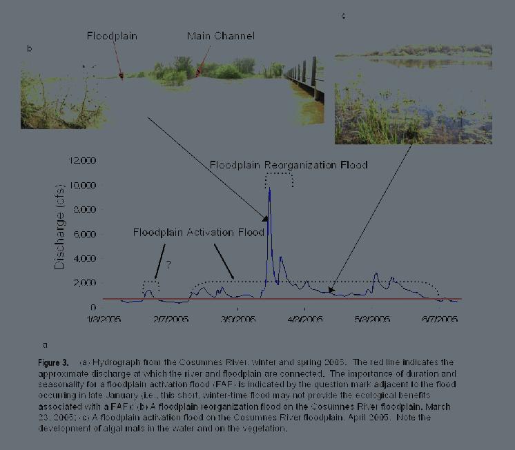
5 Organization of the conceptual model. A diverse range of flows influence floodplain geomorphic and ecological processes, ranging from flows below bankfull to large, rare, and highly erosive floods. Numerous aspects of these flows have geomorphic and ecological significance, including magnitude, frequency, duration, rates of change, and seasonality, as well as antecedent conditions on the floodplain. To simplify, our conceptual model focuses on three types of representative floods, characterized by their frequency and magnitude, which are found in the blue boxes in the Hydrology portion of the model. These floods perform geomorphic work, described in the brown-outline boxes in the Geomorphology portion of the model. Hydrologic and geomorphic processes create the conditions for Ecosystem Responses and Processes to occur (green-outlined boxes). The Ecosystem Responses and Processes produce Ecological Benefits, the magnitudes of which are influenced by the geographic scale of floodplain. Two representative floods, the Floodplain Activation Flood and the Floodplain Reorganization Flood are illustrated in Figures 2 and 3 and described below. Two representative floods Floodplain Activation Flood. The floodplain activation flood (FAF) is a smallmagnitude flood that occurs relatively frequently (e.g., almost every year) (Figure 3). The FAF can be further defined in terms of seasonality and duration for example a flood that lasts at least one week and occurs in the Spring. The following article by Betty Andrews defines a FAF in terms of frequency, season, and duration and then describes a process to map the floodplain that corresponds to the FAF in the Sacramento Valley. A long duration flood produces characteristic ecological benefits such as habitat for native fish spawning and rearing (Figure 1) and food web productivity. The duration of the flood is important as these processes cannot occur during a short event. The seasonality of the flood also influences which ecological processes occur (see the temporal scale bar (Winter Late spring) in one of the ecological process boxes). The importance of duration and seasonality for a FAF is indicated by the question mark adjacent to the flood occurring in late January on the hydrograph in Figure 2 (a short, winter-time flood). Because floodplains can remain inundated for a period of time after the loss of direct connection with river flows, a series of short connections can also function as a floodplain activation flood. Floodplain Reorganization Flood. The floodplain reorganization flood is a greater magnitude flood that occurs less frequently (Figure 3). This higher energy flood produces geomorphic work including extensive erosion and deposition on the floodplain which creates heterogeneous floodplain topography. In turn, these dynamic events and heterogeneous topography create a diverse ecosystem with vegetation patches of varying age, species composition and structure, and floodplain water bodies of varying successional stage and connectivity to the river. The ecosystem processes that occur during a Floodplain Activation Flood take place within the mosaic of habitat features created during Floodplain Reorganization Floods. Conclusions The model illustrates the importance of hydrological variability for an ecologically functional floodplain. For example, a floodplain that rarely is inundated by a Floodplain 5
6 Activation Flood will not produce the ecological benefits of food web productivity or spawning and rearing habitat for native fish. A floodplain that is not subject to Floodplain Reorganization Floods will not maintain the mosaic of habitats (e.g., vegetation and water bodies of varying successional stages) that help support floodplain biodiversity. Therefore, floodplain restoration projects should not only focus on reintroducing connectivity between rivers and floodplains. Floodplain managers should also ask the following questions about this connectivity: how often, for how long, in what season, and of what magnitude? The answers to these questions will strongly influence the range of ecological benefits that the restored floodplain can provide. CALFED Bay-Delta Program Ecosystem restoration program plan. Volume I: Ecological attributes of the San Francisco Bay-Delta watershed. Pages 532 pp. CALFED. Costanza, R., R. darge, R. degroot, S. Farber, M. Grasso, B. Hannon, K. Limburg, S. Naeem, R. V. Oneill, J. Paruelo, R. G. Raskin, P. Sutton, and M. vandenbelt The value of the world's ecosystem services and natural capital. Nature 387: Jassby, A. D., and J. E. Cloern Organic matter sources and rehabilitation of the Sacramento - San Joaquin Delta (California, USA). Aquatic Conservation: Marine and Freshwater Ecosystems 10: Schemel, L. E., T. R. Sommer, A. B. Muller-Solger, and W. C. Harrell Hydrological variability, water chemistry, and phytoplankton biomass in a large floodplain of the Sacramento River, CA, USA. Hydrobiologia 513: Sommer, T., R. Baxter, and B. Herbold Resilience of splittail in the Sacramento- San Joaquin estuary. Trans. Am. Fish. Soc. 126: Sommer, T., B. Harrell, M. Nobriga, R. Brown, P. Moyle, W. Kimmerer, and L. Schemel. 2001a. California's Yolo Bypass: evidence that flood control can be compatible with fisheries, wetlands, wildlife, and agriculture. Fisheries 26: Sommer, T. R., M. L. Nobriga, W. C. Harrell, W. Batham, and W. J. Kimmerer. 2001b. Floodplain rearing of juvenile chinook salmon: evidence of enhanced growth and survival. Canadian Journal of Fisheries and Aquatic Sciences 58:

7 Figure 2. Floodplain Conceptual Model 7
8 8
Lower South Fork McKenzie River Floodplain Enhancement Project
 Lower South Fork McKenzie River Floodplain Enhancement Project McKenzie River Ranger District Willamette National Forest Project Location The project is located in the South Fork McKenzie River Watershed,
Hydrologic Analysis for Ecosystem Restoration
 Hydrologic Analysis for Ecosystem Restoration Davis, California Objectives: To provide participants with: 1) an understanding of the issues in restoration studies; 2) an overview of Corps policies and
Opportunities to Improve Ecological Functions of Floodplains and Reduce Flood Risk along Major Rivers in the Puget Sound Basin
 Opportunities to Improve Ecological Functions of Floodplains and Reduce Flood Risk along Major Rivers in the Puget Sound Basin Christopher Konrad, US Geological Survey Tim Beechie, NOAA Fisheries Managing
Restoration Goals TFG Meeting. Agenda
 San Joaquin River Restoration Program Restoration Goals TFG Meeting Reach 2B Update April 28, 2010 Agenda 1. Introductions 2. Program Restoration Goal Context 3. Program Update a) Interim Flows b) EIS/EIR
Mobrand to Jones and Stokes. Sustainable Fisheries Management Use of EDT
 Sustainable Fisheries Management Use of EDT Ecosystem Diagnosis and Treatment EDT EDT designed to provide a practical, science-based approach for developing and implementing watershed plans. Provides decision
Changing Climate, Changing Watersheds
 Spring 2005 Watershed Management Council Networker Advancing the art & science of watershed management Changing Climate, Changing Watersheds This spectacular blue marble image is the most detailed true-color
ADDRESSING GEOMORPHIC AND HYDRAULIC CONTROLS IN OFF-CHANNEL HABITAT DESIGN
 ADDRESSING GEOMORPHIC AND HYDRAULIC CONTROLS IN OFF-CHANNEL HABITAT DESIGN Conor Shea - Hydrologist U.S. Fish and Wildlife Service Conservation Partnerships Program Arcata, CA Learning Objectives Examine
Columbia Estuary Province
 Rolling Provincial Review: Implementation 2001-2004 Province 73 Columbia Basin Fish & Wildlife Authority Province FY 2001-2004 Spending Summaries NPCC Recommendations and BPA Spending by Project Category,
Solutions to Flooding on Pescadero Creek Road
 Hydrology Hydraulics Geomorphology Design Field Services Photo courtesy Half Moon Bay Review Solutions to Flooding on Pescadero Creek Road Prepared for: San Mateo County Resource Conservation District
The Ecosystem Functions Model: A Tool for Restoration Planning
 The Ecosystem Functions Model: A Tool for Restoration Planning by John T. Hickey and Chris N. Dunn PURPOSE: The Ecosystem Functions Model (EFM) is a planning tool that analyzes ecosystem response to changes
Appendix 12J Winter-Run Chinook Salmon Life Cycle Modeling
 Appendix 12J Winter-Run Chinook Salmon Life Cycle Modeling Line items and numbers identified or noted as No Action Alternative represent the Existing Conditions/No Project/No Action Condition (described
Deriving Vegetation Characteristics from LIDAR Data and Two-Dimensional Hydraulic Modeling of the San Joaquin River Floodplain
 Study 50 Deriving Vegetation Characteristics from LIDAR Data and Two-Dimensional Hydraulic Modeling of the San Joaquin River Floodplain Final 2015 Monitoring and Analysis Plan January 2015 1.0 Deriving
How Do Human Impacts and Geomorphological Responses Vary with Spatial Scale in the Streams and Rivers of the Illinois Basin?
 How Do Human Impacts and Geomorphological Responses Vary with Spatial Scale in the Streams and Rivers of the Illinois Basin? Bruce Rhoads Department of Geography University of Illinois at Urbana-Champaign
EAGLES NEST AND PIASA ISLANDS
 EAGLES NEST AND PIASA ISLANDS HABITAT REHABILITATION AND ENHANCEMENT PROJECT MADISON AND JERSEY COUNTIES, ILLINOIS ENVIRONMENTAL MANAGEMENT PROGRAM ST. LOUIS DISTRICT FACT SHEET I. LOCATION The proposed
Ecosystem response during the removal of the Elwha River Dams
 Ecosystem response during the removal of the Elwha River Dams Presentation Prepared by George Pess - NOAA Photo by John McMillan December 2015 Elwha The Elwha River Basin Olympic Natl. Park > 90% of habitat
Sprague River Basin Restoration Post Project Evaluations: Lessons Learned and Future Applications
 River Restoration Northwest, 2015 Sprague River Basin Restoration Post Project Evaluations: Lessons Learned and Future Applications Mark R. Tompkins, P.E., Ph.D. ACKNOWLEDGEMENTS The Klamath Tribes Larry
Folsom Dam Water Control Manual Update Joint Federal Project, Folsom Dam
 Folsom Dam Water Control Manual Update Joint Federal Project, Folsom Dam Public Workshop May 25, 2016 Sacramento Library Galleria 828 I Street, Sacramento, CA US Army Corps of Engineers BUILDING STRONG
Assessment. Assessment
 2001 SPRINGBROOK CREEK RESTORATION - THREE YEAR POST-CONSTRUCTION REVIEW - Presented by Bruce Henderson and Andy Harris 2005 River Restoration Northwest Symposium Skamania Lodge, Washington www.hendersonlandservices.com
Elwha River response to dam removals through four years and a big flood:
 Elwha River response to dam removals through four years and a big flood: Lessons learned, channel response, and sediment effects from the world s largest engineered dam removal Andy Ritchie NPS Elwha Restoration
Dam Removal Analysis Guidelines for Sediment
 A review of: Dam Removal Analysis Guidelines for Sediment Joe Rathbun (Retired) rathbunj@sbcglobal.net Some Potential Sediment Issues Reservoir restoration Downstream water quality Downstream deposition
Birch Creek Geomorphic Assessment and Action Plan
 Birch Creek Geomorphic Assessment and Action Plan Jim Webster Tim Hanrahan, PhD, CFM Jesse Schwartz, PhD Zach Hill January 22, 2015 White Eagle Grange This Project is a First Step in Strategy Planning
Island Design. UMRS EMP Regional Workshop. Presentation for the
 Island Design Presentation for the UMRS EMP Regional Workshop by Jon Hendrickson Hydraulic Engineer Regional Technical Specialist, Water Quality and Habitat Restoration August 17 19, 2005 Project Delivery
Coastal Impacts of Climate Change in the Northwest: A Summary of the Findings of the upcoming National Climate Assessment
 Western Washington University Western CEDAR Salish Sea Ecosystem Conference 2014 Salish Sea Ecosystem Conference (Seattle, Wash.) May 1st, 3:30 PM - 5:00 PM Coastal Impacts of Climate Change in the Northwest:
The Refugia Concept: Using Watershed Analysis to Prioritize Salmonid Habitat for Conservation and Restoration
 The Refugia Concept: Using Watershed Analysis to Prioritize Salmonid Habitat for Conservation and Restoration Christopher May Battelle & UW Cumulative Impacts of Urbanization Landscape Alterations Loss
Hydraulic and Sediment Transport Modeling Strategy
 Appendix B Hydraulic and Sediment Transport Modeling Strategy May 2014 Technical Memorandum Channel Capacity Report January 2015 San Joaquin River Restoration Program Hydraulic and Sediment Transport Modeling
What is a watershed or landscape perspective?
 What is a watershed or landscape perspective? -remove sediment -add sediment -add wood, riparian manipulation -alter (engineer) channel/floodplain morphology -restore/abandon roads You are here What is
Conceptual Model of Stream Flow Processes for the Russian River Watershed. Chris Farrar
 Conceptual Model of Stream Flow Processes for the Russian River Watershed Chris Farrar Several features of creeks affect the interactions between surface and groundwater. This conceptual model uses the
Evaluation of Geomorphic Effects of Removal of Marmot and Little Sandy Dams and Potential Impacts on Anadromous Salmonids
 PRELIMINARY FINAL Evaluation of Geomorphic Effects of Removal of Marmot and Little Sandy Dams and Potential Impacts on Anadromous Salmonids Prepared for: Portland General Electric 121 SW Salmon Street
Ecosystems Chapter 4. What is an Ecosystem? Section 4-1
 Ecosystems Chapter 4 What is an Ecosystem? Section 4-1 Ecosystems Key Idea: An ecosystem includes a community of organisms and their physical environment. A community is a group of various species that
Physical modeling to guide river restoration projects: An Overview
 Physical modeling to guide river restoration projects: An Overview Scott Dusterhoff¹, Leonard Sklar², William Dietrich³, Frank Ligon¹, Yantao Cui¹, and Peter Downs¹ ¹Stillwater Sciences, 2855 Telegraph
The Effects of Geomorphology and Watershed Land Use on Spawning Habitat
 The Effects of Geomorphology and Watershed Land Use on Spawning Habitat By Evan Buckland INTRODUCTION The distribution and frequency of large geomorphic features in a watershed govern where suitable spawning
Fig 1. Steps in the EcoValue Project
 Assessing the Social and Economic Value of Ecosystem Services in the Northern Forest Region: A Geographic Information System (GIS) Approach to Landscape Valuation Principal Investigator(s): Dr. Matthew
Heather Schlosser Army Corps of Engineers Coastal Studies Group August 28, 2008
 Got sand? Regional Sediment Management in Orange County Heather Schlosser Army Corps of Engineers Coastal Studies Group August 28, 2008 Regional Sediment Management Regional sediment management recognizes
Great California Delta Trail Blueprint for Contra Costa and Solano Counties GIS AND MAPPING MEMORANDUM JULY 2010
 Great California Delta Trail Blueprint for Contra Costa and Solano Counties GIS AND MAPPING MEMORANDUM JULY 2010 {DRAFT} July 2010 Introduction Geographic Information Systems (GIS) are computer-based
Restoring the Napa River:
 Restoring the Napa River: lessons learned from a long term private-public project Andy Collison Environmental Science Associates acollison@esassoc.com 1 Napa River Restoration Projects Rutherford Reach
Why Stabilizing the Stream As-Is is Not Enough
 Why Stabilizing the Stream As-Is is Not Enough Several examples of alternatives to the County s design approach have been suggested. A common theme of these proposals is a less comprehensive effort focusing
Overview of Methods. Terrestrial areas that are most important for conservation Conservation
 Overview of Methods The goal of the Western Lake Erie Coastal Conservation Vision project (WLECCV) is to define where we should be working locally to optimally achieve regional conservation impact. The
Beaver Dam Influence on Wet Meadow Habitat
 Beaver Dam Influence on Wet Meadow Habitat HOPE FISHER WRITER S COMMENT: I ve always been fascinated by the natural world. This deep appreciation for nature and passion for conservation inspired me to
Restoring Rivers in Cumbria Online Story Map of a case study on the River Lyvennet
 Restoring Rivers in Cumbria Online Story Map of a case study on the River Lyvennet Summary This Story Map presents a river restoration case study for the River Eden Catchment, Cumbria. Students can learn
Upper Truckee River Restoration Lake Tahoe, California Presented by Brendan Belby Sacramento, California
 Upper Truckee River Restoration Lake Tahoe, California Presented by Brendan Belby Sacramento, California Mike Rudd (Project Manager), Charley Miller & Chad Krofta Declines in Tahoe s Water Clarity The
Restoration of Dynamic Flood Plain Topography and Riparian Vegetation Establishment Through Engineered Levee Breaching
 Restoration of Dynamic Flood Plain Topography and Riparian Vegetation Establishment Through Engineered Levee Breaching JEFFREY F. MOUNT, JOAN L. FLORSHEIM AND WENDY B. TROWBRIDGE Center for Integrated
Introduction Fluvial Processes in Small Southeastern Watersheds
 Introduction Fluvial Processes in Small Southeastern Watersheds L. Allan James Scott A. Lecce Lisa Davis Southeastern Geographer, Volume 50, Number 4, Winter 2010, pp. 393-396 (Article) Published by The
Spatial Units (Level 1)
") Spatial Units (Level 1) Project: Advancing the SEEA Experimental Ecosystem Accounting Overview: Spatial Units 1. Learning objectives 2. Review of Level 0 (5m) 3. Level 1 (Compilers): Presentation & group
Spatial Units (Level 1) Project: Advancing the SEEA Experimental Ecosystem Accounting Overview: Spatial Units 1. Learning objectives 2. Review of Level 0 (5m) 3. Level 1 (Compilers): Presentation & group
Thank you to all of our 2015 sponsors: Media Partner
 Thank you to all of our 2015 sponsors: Media Partner Fluvial System Concepts and Their Application in Greenfield Stream Corridor Realignment Dr. Paul Villard, P.Geo. GEO Morphix Ltd. Overview Major realignment
Wetland & Floodplain Functional Assessments and Mapping To Protect and Restore Riverine Systems in Vermont. Mike Kline and Laura Lapierre Vermont DEC
 Wetland & Floodplain Functional Assessments and Mapping To Protect and Restore Riverine Systems in Vermont Mike Kline and Laura Lapierre Vermont DEC NWI+ Hydro-Geomorphic Characterization of Wetlands and
Use of benthic invertebrate biological indicators in evaluating sediment deposition impairment on the Middle Truckee River, California
 Use of benthic invertebrate biological indicators in evaluating sediment deposition impairment on the Middle Truckee River, California David B. Herbst Sierra Nevada Aquatic Research Laboratory University
Start of Presentation: No notes (Introductory Slide 1) 1) Salmonid Habitat Intrinsic Potential (IP) models are a type of habitat potential
 1) Salmonid Habitat Intrinsic Potential (IP) models are a type of habitat potential") The What and How of Salmonid Habitat Intrinsic Potential Modeling Start of Presentation: No notes (Introductory Slide 1) 1) Salmonid Habitat Intrinsic Potential (IP) models are a type of habitat potential
The What and How of Salmonid Habitat Intrinsic Potential Modeling Start of Presentation: No notes (Introductory Slide 1) 1) Salmonid Habitat Intrinsic Potential (IP) models are a type of habitat potential
Framework for the Basin-Wide Socio-Economic Analysis of Four Proposed Sediment Diversions. August 4, 2015
 Framework for the Basin-Wide Socio-Economic Analysis of Four Proposed Sediment Diversions August 4, 2015 Proposed Sediment Diversions Mid-Breton Mid-Barataria Lower Barataria Lower Breton Overview of Presentation
Case Study 2: Twenty-mile Creek Rock Fords
 Case Study : Twenty-mile Creek Rock Fords Location Crossing Description Washington. Okanagan National Forest. Methow Valley Ranger District. Chewuch river basin, East Chewuch Road. The Twenty-mile Creek
Modeling Post-Development Runoff and Channel Impacts from Hydromodification: Practical Tools for Hydromodification Assessment
 Modeling Post-Development Runoff and Channel Impacts from Hydromodification: Practical Tools for Hydromodification Assessment Chris Bowles, Ph.D. Andy Collison, Ph.D. Matt Wickland, M.S. c.bowles@pwa-ltd.com
MISSOURI LiDAR Stakeholders Meeting
 MISSOURI LiDAR Stakeholders Meeting East-West Gateway June 18, 2010 Tim Haithcoat Missouri GIO Enhanced Elevation Data What s different about it? Business requirements are changing.fast New data collection
1.1 What is Site Fingerprinting?
 Site Fingerprinting Utilizing GIS/GPS Technology 1.1 What is Site Fingerprinting? Site fingerprinting is a planning tool used to design communities where protection of natural resources is the primary
RIVER RESEARCH AND APPLICATIONS
 RIVER RESEARCH AND APPLICATIONS Published online in Wiley InterScience (www.interscience.wiley.com). DOI: 10.1002/rra.911 A GEOMORPHIC MONITORING AND ADAPTIVE ASSESSMENT FRAMEWORK TO ASSESS THE EFFECT
Savannah District s Revised SOP: Moving Towards A Functional Approach. US Army Corps of Engineers BUILDING STRONG
 Savannah District s Revised SOP: Moving Towards A Functional Approach US Army Corps of Engineers Agenda SOP Revision Concept New Aquatic Resource Credit Types New Urban Mitigation Service Area Filter Background
Natural Shoreline Landscapes on Michigan Inland Lakes
 Natural Shoreline Landscapes on Michigan Inland Lakes Excerpts from Chapters 2 and 3 Photo Photo by Jane by Jane Herbert Herbert Did you know? Twenty-four species of amphibians, 25 species of reptiles,
Aquifer an underground zone or layer of sand, gravel, or porous rock that is saturated with water.
 Aggradation raising of the streambed by deposition that occurs when the energy of the water flowing through a stream reach is insufficient to transport sediment conveyed from upstream. Alluvium a general
A NEW GIS-BASED RIVER BASIN FRAMEWORK
 A NEW GIS-BASED RIVER BASIN FRAMEWORK FOR AQUATIC ECOSYSTEM CONSERVATION IN THE AMAZON www.amazonwaters.org info@amazonwaters.org 2 3 Introduction The Amazon Waters Initiative is a call to action to conceptualize
Geographic Information Systems (GIS) and inland fishery management
 and inland fishery management") THEMATIC REPORT Geographic Information Systems (GIS) and inland fishery management Stratified inland fisheries monitoring using GIS Gertjan DE GRAAF Nefisco, Amsterdam, the Netherlands Felix MARTTIN and
THEMATIC REPORT Geographic Information Systems (GIS) and inland fishery management Stratified inland fisheries monitoring using GIS Gertjan DE GRAAF Nefisco, Amsterdam, the Netherlands Felix MARTTIN and
Subcommittee on Sedimentation Draft Sediment Analysis Guidelines for Dam Removal
 Subcommittee on Sedimentation Draft Sediment Analysis Guidelines for Dam Removal August 4, 2011 Jennifer Bountry, M.S., P.E. Tim Randle, M.S., P.E., D.WRE. Blair Greimann, Ph.D., P.E. Sedimentation and
Final Report for the Green Valley Creek Winter Refugia Enhancement Project Monitoring December 2016
 Final Report for the Green Valley Creek Winter Refugia Enhancement Project Monitoring December 2016 Prepared by: Mariska Obedzinski and Sarah Nossaman University of California Cooperative Extension & California
3.3 CLIMATE, GEOLOGY, TOPOGRAPHY, AND SOILS CLIMATE GEOLOGY TOPOGRAPHY
 3.3 CLIMATE, GEOLOGY, TOPOGRAPHY, AND SOILS This section describes the climate, geology, topography, and soil resource characteristics of the Yolo Bypass Wildlife Area (Wildlife Area). Agricultural soil
Spatial units (Levels 0 and 1)
") Spatial units (Levels 0 and 1) Project: Advancing the SEEA Experimental Ecosystem Accounting Overview: Spatial units 1. Learning objectives 2. Level 1: Presentation & group exercise Spatial units (10m
Spatial units (Levels 0 and 1) Project: Advancing the SEEA Experimental Ecosystem Accounting Overview: Spatial units 1. Learning objectives 2. Level 1: Presentation & group exercise Spatial units (10m
06/04/2015. Overview: Spatial units. Advancing the SEEA Experimental Ecosystem Accounting Spatial units (Level 1)
") Advancing the SEEA Experimental Ecosystem Accounting Spatial units (Level 1) Advancing the SEEA-EEA Project Overview: Spatial units 1. Learning objectives 2. Level 1: Presentation & group exercise Spatial
Advancing the SEEA Experimental Ecosystem Accounting Spatial units (Level 1) Advancing the SEEA-EEA Project Overview: Spatial units 1. Learning objectives 2. Level 1: Presentation & group exercise Spatial
MESM Track. Environmental Policy and Management
 MESM Track Environmental Policy and Management Overview This interdisciplinary track prepares students for positions requiring an ability to integrate natural science into policy development and implementation
Changes in Texas Ecoregions
 Comment On Lesson Changes in Texas Ecoregions The state of Texas can be divided into 10 distinct areas based on unique combinations of vegetation, topography, landforms, wildlife, soil, rock, climate,
The Danube River. Hydrological Connectivity and Human Influence. By: Pat O Connell, Pat Wilkins, Tiana Royer, and Kevin Gaitsch
 The Danube River Hydrological Connectivity and Human Influence By: Pat O Connell, Pat Wilkins, Tiana Royer, and Kevin Gaitsch Danube River Characteristics Length: 2860 km Drainage Area: 816,000 km 2 Peak
United States Department of the Interior NATIONAL PARK SERVICE Northeast Region
 United States Department of the Interior NATIONAL PARK SERVICE Northeast Region June 17, 2017 REQUEST FOR STATEMENTS OF INTEREST and QUALIFICATIONS Project Title: ASSESSMENT OF NATURAL RESOURCE CONDITION
Coastal Environment. Introduction. 4.1 Coastal Environment. Extent of Coastal Environment
 4 The primary objective (set out in Chapter 2) to be implemented by this Chapter is Objective 2.4 ; the following objectives are also relevant due to the objectives integrated nature: 2.1 Tāngata whenua
3.1 Regional Physical Setting
 Chapter 3 Hydrogeomorphic Setting This chapter describes the physical setting of the inventory area and the four physiographic regions used to categorize the geomorphology of the inventory area. The overview
VEGETATION EVA BOEHRINGER
 VEGETATION EVA BOEHRINGER April 2, 2014 WUP CONSULTATIVE COMMITTEE WUP Consultative Committee (WUP CC) recognized that riparian and wetland vegetation in the reservoir drawdown zone is valuable for fish,
Restoring Entrenched Rivers: lessons learned from the
 Restoring Entrenched Rivers: lessons learned from the N i PProject j Napa Ri River RRestoration Andy Collison Geomorphologist ESA PWA acollison@esassoc.com Napa County Flood Control and Water Conservation
Tom Ballestero University of New Hampshire. 1 May 2013
 Tom Ballestero University of New Hampshire 1 May 2013 1 Hydrology 2 Basic Hydrology Low flows most common Flows that fill the stream to the banks and higher are much less common Filling the stream to the
Conserving freshwater ecosystem values in Tasmania, Australia: identification and application of freshwater conservation management priority areas
 Conserving freshwater ecosystem values in Tasmania, Australia: identification and application of freshwater conservation management priority areas Danielle Hardie 1 and Peter Davies 2 1 Department of Primary
Kootenai River Habitat Restoration Program Update
 Kootenai River Habitat Restoration Program Update Kootenai Tribe of Idaho Kootenai Valley Resource Initiative November 19, 2012 Bonners Ferry, Idaho Changes to Kootenai Basin Beaver trapping Floodplain
Why Geomorphology for Fish Passage
 Channel Morphology - Stream Crossing Interactions An Overview Michael Love Michael Love & Associates mlove@h2odesigns.com (707) 476-8938 Why Geomorphology for Fish Passage 1. Understand the Scale of the
UC Berkeley Technical Completion Reports
 UC Berkeley Technical Completion Reports Title Hydrodynamics of shallow water habitats in the Sacramento-San Joaquin Delta Permalink https://escholarship.org/uc/item/3j77h7t6 Author Stacey, Mark T Publication
SAN FRANCISCO DISTRICT INFORMATION REQUESTED FOR VERIFICATION OF CORPS JURISDICTION
 DEPARTMENT OF THE ARMY SAN FRANCISCO DISTRICT, U.S. ARMY CORPS OF ENGINEERS 1455 MARKET STREET SAN FRANCISCO, CALIFORNIA 94103-1398 SAN FRANCISCO DISTRICT INFORMATION REQUESTED FOR VERIFICATION OF CORPS
3.11 Floodplains Existing Conditions
 Other stormwater control practices may be needed to mitigate water quality impacts. In addition to detention facilities, other practices such as vegetated basins/buffers, infiltration basins, and bioswales
We are interconnected, we are resilient As air temperatures warm forests change, fires increase glaciers retreat, snowpack diminishes sediment
 We are interconnected, we are resilient As air temperatures warm forests change, fires increase glaciers retreat, snowpack diminishes sediment increases rivers change, salmon respond base sea level rises
Investigating the contribution of allochthonous subsidies to kelp forests in central California
 Investigating the contribution of allochthonous subsidies to kelp forests in central California melissa m foley UCSC Institute of Marine Science and Center for Ocean Solutions system connectivity rivers
Types of Wetlands. Tidal Systems
 Types of Wetlands Tidal Systems 1 COASTAL WETLAND ECOSYSTEMS Tidal Salt Marshes Tidal Freshwater Marshes Mangrove Wetlands 2 Tidal Estuarine Wetland 3 Definition and Formation of Estuaries Estuary: : partially
Geomorphology Of The Chilliwack River Watershed Landform Mapping At North Cascades National Park Service Complex, Washington By National Park Service
 Geomorphology Of The Chilliwack River Watershed Landform Mapping At North Cascades National Park Service Complex, Washington By National Park Service READ ONLINE Snowshed contributions to the Nooksack
Subtidal permanently flooded with tidal water. Irregularly exposed surface exposed by tides less often than daily
 Types of Wetlands Tidal Systems COASTAL WETLAND ECOSYSTEMS Tidal Salt Marshes Tidal Freshwater Marshes Mangrove Wetlands Tidal Estuarine Wetland 1 Definition and Formation of Estuaries u Estuary : partially
Four Mile Run Levee Corridor Stream Restoration
 Four Mile Run Levee Corridor Stream Restoration 30% Design Summary U.S. Army Corps of Engineers, Baltimore District Presentation Outline Four Mile Run 1.) Historic Perspective 2.) Existing Conditions 3.)
COLUSA BASIN WATERSHED ASSESSMENT. Final. Prepared by: H. T. Harvey & Associates. In Collaboration With:
 COLUSA BASIN WATERSHED ASSESSMENT Prepared by: In Collaboration With: G. Mathias Kondolf Geomorph Blankinship & Associates Prepared for: Colusa County Resource Conservation District 100 Sunrise Boulevard,
Best Management Practices for Coldwater Fisheries Enhancement and Restoration
 Best Management Practices for Coldwater Fisheries Enhancement and Restoration MACC Annual Environmental Conference 2017 March 3, 2017 Tim Dexter, MassDOT Highway Division 1 Leading the Nation in Transportation
Landscape Planning Framework
 Landscape Planning Framework Fish Habitat Catena Geodatabase Methodology Mary Ramirez 1 Charles Simenstad 1 Phil Trask 2 Allan Whiting 2 Alex McManus 2 Funding provided by the Bonneville Power Administration
BASIS FOR RIVER RESTORATION PROJECT
 The FLUVIO FCT-Doctoral Program Hydromorphological and Habitat Restoration Course Diego García de Jalón and Marta González del Tánago, UPM Madrid BASIS FOR RIVER RESTORATION PROJECT Throughout the course,
Georgia Performance Standards for Urban Watch Restoration Field Trips
 Georgia Performance Standards for Field Trips 6 th grade S6E3. Students will recognize the significant role of water in earth processes. a. Explain that a large portion of the Earth s surface is water,
Hannah Moore CEE Juvenile Bull Trout Distribution in the South Fork Walla Walla River, Oregon
 Hannah Moore CEE 6440 Juvenile Bull Trout Distribution in the South Fork Walla Walla River, Oregon Introduction Bull trout (Salvelinus confluentus) are an endangered species historically found throughout
Betsy Stevenson and Allison Mohrs (Skagit County Planning and Development Services) Jenny Baker, The Nature Conservancy
 Jenny Baker, The Nature Conservancy") TC Fisher Slough Final Design and Permitting Subject: Well Review Memorandum To: From: Betsy Stevenson and Allison Mohrs (Skagit County Planning and Development Services) Jenny Baker, The ature Conservancy
TC Fisher Slough Final Design and Permitting Subject: Well Review Memorandum To: From: Betsy Stevenson and Allison Mohrs (Skagit County Planning and Development Services) Jenny Baker, The ature Conservancy
HISTORICAL DELTA LANDSCAPES Conceptual models for building a diverse and resilient future
 HISTORICAL DELTA LANDSCAPES ITEM REMOVED DUE TO COPYRIGHT STATUS Conceptual models for building a diverse and resilient future Robin Grossinger and Alison Whipple San Francisco Estuary Institute/Aquatic
Relatively little hard substrate occurs naturally in the
 CHAPTER FIVE Rock Habitats Relatively little hard substrate occurs naturally in the estuary, owing mainly to the vast quantities of fine sediment that have been deposited by the rivers. Rock habitat is
May 7, Roger Leventhal, P.E. Marin County Public Works Laurel Collins Watershed Sciences
 May 7, 2013 Roger Leventhal, P.E. Marin County Public Works Laurel Collins Watershed Sciences Background Funded in 2009 under EPA 2100 Grant for $30k and managed by SFEP Project Goals: Update original
ANIMAL ECOLOGY (A ECL)
") Animal Ecology (A ECL) 1 ANIMAL ECOLOGY (A ECL) Courses primarily for undergraduates: A ECL 312: Ecology (Cross-listed with BIOL, ENSCI). (3-3) Cr. 4. SS. Prereq: BIOL 211, BIOL 211L, BIOL 212, and BIOL
Animal Ecology (A ECL) 1 ANIMAL ECOLOGY (A ECL) Courses primarily for undergraduates: A ECL 312: Ecology (Cross-listed with BIOL, ENSCI). (3-3) Cr. 4. SS. Prereq: BIOL 211, BIOL 211L, BIOL 212, and BIOL
Land Accounts - The Canadian Experience
 Land Accounts - The Canadian Experience Development of a Geospatial database to measure the effect of human activity on the environment Who is doing Land Accounts Statistics Canada (national) Component
COURSES OUTSIDE THE JOURNALISM SCHOOL
 COURSES OUTSIDE THE JOURNALISM SCHOOL Students are not limited to the science courses on this list and may select classes from additional specialties. In accordance with University policy, 400-level courses
An Introduction to Day Two. Linking Conservation and Transportation Planning Lakewood, Colorado August 15-16, 16, 2006
 An Introduction to Day Two Linking Conservation and Transportation Planning Lakewood, Colorado August 15-16, 16, 2006 1 Agenda Day One Transportation Planning Heritage Program State Wildlife Action Plan
Southwest LRT Habitat Analysis. May 2016 Southwest LRT Project Technical Report
 Southwest LRT Habitat Analysis Southwest LRT Project Technical Report This page intentionally blank. Executive Summary This technical report describes the habitat analysis that was performed to support
Welcome to NetMap Portal Tutorial
 Welcome to NetMap Portal Tutorial Potential Applications What Can you do with the Portal? At least 25 things! 1) Locate the best potential fish habitats. 2) Identify biological hotspots. 3) Map floodplain