May Creek Canyon LWD Stream Restoration Project. Helicopter Placement of LWD in an Urban Stream. By Kathryn Neal, P.E.
|
|
|
- Conrad Barnett
- 6 years ago
- Views:
Transcription
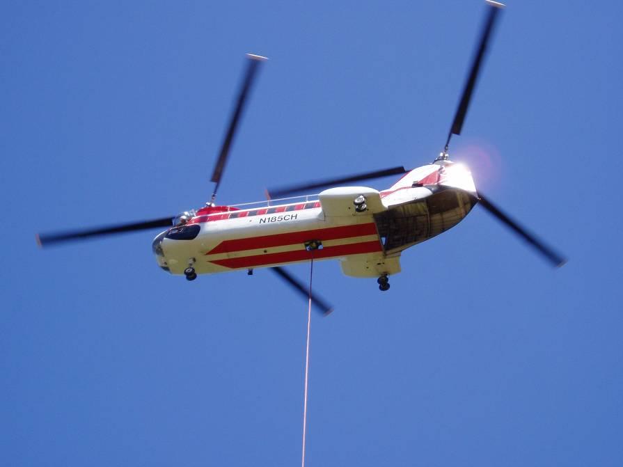
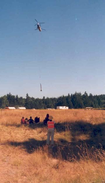
1 Helicopter Placement of LWD in an Urban Stream By Kathryn Neal, P.E. May Creek Canyon LWD Stream Restoration Project By Kathryn Neal, P.E. Project proponents: King County City of Renton City of Newcastle King Conservation District 1


2 Overview of May Creek Basin Lake Washington Watershed Basin overlaps three jurisdictions: King County - 68% Renton - 12% Newcastle - 20% Basin divided by Urban Growth Boundary May Creek is 7 miles long, 22cfs mean annual flow May Creek Canyon wooded ravine between suburbs 2


3 Design Goals Salmon Habitat 3


4 Add Large Woody Debris Improve Riparian Vegetation Improve Aquatic Habitat Stream Channel Protection Reduce Sediment Delivery 4

5 May Canyon Stream Restoration PROJECT DESIGN SUMMARY Mobility of unanchored wood was analyzed Flow data was readily available Construction feasibility Safety Public communication Unanchored LWD, placed in clusters 20 clusters along 1.2 miles of May Creek canyon Helicopter placement 100 logs with rootwads, some with branches Plant 2000 conifers in 2003, more later 5


6 May Creek Canyon LWD Placement Locations 6

7 7

8 Construction Preparation For Helicopter Work in an Urban Setting Buy and stage the LWD Harvest donated trees Coordinate with Utilities especially BPA and PSE Plan flight patterns Contract for helicopter, pilot, and crew Plan for Safety construction workers and public at large Notify the public Secure the work site Prepare the LWD drop sites in the stream 8

9 2003 Project Team Hours 2003 Labor Hours for May Canyon Stream Restoration Wood Placement Day Hours JAN FEB MAR APR MAY JUN JUL AUG SEP OCT NOV DEC Month 9

10 10

11 11

12 Benefits of LWD What can we expect? Increase hydraulic complexity Add roughness Increase habitat complexity Create scour pools and slow water habitat Affect sediment storage and movement Provide nutrients and woody substrate for aquatic life Refuge hiding and thermal cover 12


13 Typical LWD Placement All unanchored Aggressive in-channel placement Most placed in clusters of 2-3 logs Some individual Key pieces placed Primarily targeted homogenous reaches with minimal LWD or hydraulic complexity Also in incised reaches upstream of Newcastle Creek Relatively High Costs 13


14 Many Participants Working Together High Benefits? 14


15 Monitoring of the May Canyon Stream Restoration Project Purpose of this Monitoring Project To inform design teams and improve the design of LWD placement projects in the future. To document the effects of this and other similar LWD placement projects in urbanizing regions. by Dan Eastman CIP Monitoring and Maintenance Program To generate graphics that can be easily interpreted and presented to various audiences To demonstrate King County s overall commitment to monitoring and understanding the effects of our restoration projects. 15
16 Goals and Objectives of Monitoring Primary Goal To understand & document geomorphic response & aquatic habitat changes in small streams where Large Woody Debris is added as a restorative measure Objectives: To understand and document: Type and degree of physical changes. Type and degree of changes in aquatic habitat. Mobility of placed LWD. How far does it move and under what flow conditions? If particular LWD configurations are more effective. How LWD placement affects sediment transport and storage? Aerial Photo of project reach showing T1, T2, T3 and C2 Surveyed 4, 60 meter reaches 3 with placed LWD, one without. 16
")
17 High Resolution Topographic Survey High density of survey shots throughout reaches Extensive permanent control points established Surveyed beyond immediate stream channel LWD position and size surveyed and recorded Edge of water surveyed during low flow Additional Data Collected Habitat Surveys - boundaries between slow and fast water habitats Fish Abundance Survey - (2003 baseline only) Substrate Composition - (2003 baseline only) 17
18 CFS /1/2003 LWD placement July, 2003 Monitoring Timeline Figure 6: Maximum Daily Discharge at Study Reach Relative to Project and Survey Dates The highest flows betweent the two survey dates was between a 2.5 and 3 year (annual series) recurrence interval flow. 7/31/2003 8/30/2003 9/29/ /29/ /28/2003 Baseline Survey Sept, /28/2003 1/27/2004 Date 2/26/2004 3/27/2004 ~2.5 yr. flood event Jan Construction July 2003 Baseline Survey September 2003 Survey of 10/21 High Water Mark Final Survey Septeber 2004 Max. Daily Flow at Study Reach 4/26/2004 5/26/2004 6/25/2004 7/25/2004 8/24/2004 9/23/2004 Repeat Survey Sept No Survey Activity in 2005 or 2006 Geomorphic and Aquatic Habitat Parameters all four surveyed reaches in 2003 and Total pool & riffle volume and surface area. 2. % pool and riffle habitat per unit volume 3. Residual pool depth and volume 4. Total # of Habitat Units and # of pools 5. Total thalweg length 6. Quantity of scour/deposition (net) 7. Distance LWD moved between survey dates 8. Change in parameters 1-6 between survey dates can be compared between treatment reaches and control reach. 18


19 Graphics Generated From Surveys Plan view, color graphic showing water depth, LWD position/size, location of pools and riffles, etc. in each of the 4 reaches for each survey date. Results to Date The Unreadable Data Table Corresponding thalweg profiles with stationing. Plan view graphic showing the amount and location of scour and deposition throughout each reach between survey dates. Plan view graphic showing LWD movement between survey dates. 19
20 T water depth, wood position, habitat units and longitudinal profile T water depth, wood position, habitat units and longitudinal profile Focus on this Log 20
21 T water depth, wood position, habitat units and longitudinal profile T water depth, wood position, habitat units and longitudinal profile Focus on this area 21
22 T water depth, wood position, habitat units and longitudinal profile T water depth, wood position, habitat units and longitudinal profile Focus on the stream profile 22
23 T water depth, wood position, habitat units and longitudinal profile T water depth, wood position, habitat units and longitudinal profile Focus on the edge of water here 23

24 T1 Scour and Deposition Experienced Between Survey Dates T Lower reach looking upstream 24


25 T Lower Jam looking downstream T upper pool looking downstream 25

26 T upper pool looking downstream T water depth, wood position, habitat units and longitudinal profile Focus on this Log 26
27 T water depth, wood position, habitat units and longitudinal profile T water depth, wood position, habitat units and longitudinal profile Focus on the edge of water here 27
28 T2 Scour and Deposition Experienced Between Survey Dates T water depth, wood position, habitat units and longitudinal profile Focus on this area 28
29 T water depth, wood position, habitat units and longitudinal profile T water depth, wood position, habitat units and longitudinal profile Focus on this area 29
30 T3 Scour and Deposition Experienced Between Survey Dates C water depth, wood position, habitat units and longitudinal profile Focus on this area 30
31 C water depth, wood position, habitat units and longitudinal profile C water depth, wood position, habitat units and longitudinal profile Focus on this log 31
32 C2 Scour and Deposition Experienced Between Survey Dates LWD Movement Throughout Entire Project Reach ( Observations) No placed LWD moved beyond downstream structure Moderate flood events in 2003/2004 water year resulted in substantial LWD movement 64 of the 89 (72%) tracked logs moved < 30 feet Of the 25 logs that moved > 30 feet downstream 13 moved only 30 to 100 feet downstream 10 moved 100 to 200 feet downstream - some were large pieces (e.g. a 24 dbh x 26 long x 3.5 rootwad moved 160 downstream) 2 moved more than 300 feet downstream Minimal movement during 2004/2005 water year 32
33 Conclusions to Date Deposition and scour around LWD increased the physical complexity of the streambed in treatment reaches There was a corresponding increase in aquatic habitat complexity and quality in treatment reaches. Substantial change was also observed in control reach, but the end result was simplification of the aquatic habitat More To Come!!! Only presented results of several moderate floods Is LWD still stable under highest flows and after some decay? How persistent are habitat improvements? Daily Max flows 1991 thru Coal Creek Rd Most LWD pieces were somewhat mobile even under moderate flow conditions during the 1 st winter, but movement was negligible during the 2 nd winter. c.f.s Project Construction/ First Survey (9/2003) Second Survey (9/2004) This methodology is an effective means of communicating the effects of these projects to other professionals, landowners, clients, etc Date (1991-1/3/2006) 33
34 Acknowledgements May Canyon Project Team Kathryn Neal, John Bethel, Kerry Bauman, Ingrid Haynes, Paul Adler, Abel Eckhardt and WCC crews May Canyon Monitoring Team John Bethel, Kathryn Neal, Laird O Rollins, Laura Hartema, Meredith Radella, Lucy Traxinger, Beth Carpenter, Larry Goulet, Hans Berge ESM Civil Engineers Stephen Phillips and survey crews King County Management For supporting this and other monitoring projects THE END 34
35 May Canyon LWD life to Date Expeditures compared with Original 2003 estimate last updated 1/18/2005 Proposed and Approved by management prior to project initiation Phase 1 - Baseline Survey (2003) 2003 Actual Expenditure Original 2003 estimate ESM Baseline survey - 4 reaches $ 31,500 CPOSA Contract set-up (1), and mgt (lydna) $ 2,500 CPOSA Project management and senior ecologist $ 13,000 $64,000 Original estimate for detailed topo, habitat and fish CPOSA support staff $ 7,500 abundance surveys with no substantial analysis this subtotal $ 54,500 year. Phase 2-2nd survey & analysis/presentation of 1st and 2nd survey results (2004, 2005 and 1st qtr 2006) 2004 Actual Expenditure Original 2003 estimate ESM Repeat Survey of 4 reaches $ 10,900 CPOSA Project manager and senior ecologist $ 5,500 CPOSA support staff $ 1,500 CPOSA Contract set-up (2), and mgt (lydna) $ 3,000 subtotal $ 20, ESM Data Processing and graphics production $ 13,400 $61,000 Original estimate for detailed topo, habitat and fish CPOSA Project management $ 1,900 abundance surveys and interim analysis and CPOSA staff support in analysis and poster production $ 15,600 presentation of results showing changes between CPOSA Contract set-up (1), and mgt (lydna) $ 1,000 survey dates subtotal $ 31, ESM Final Data processing and graphics production $ 6,200 CPOSA presentation preparation $ 8,700 subtotal $ 14,900 Actual Expenditure Original 2003 estimate TOTAL Life to Date $ 122,200 $125,000 orginal estimate for first two phases. Summary stats. CPOSA labor $ 60,200 ESM survey, compilation, analysis and graphics $ 62,000 ESM survey alone $ 42,400 ESM data compilation and graphics $ 19,600 Phase 3 = 3rd survey after very large event (>10 yr) Actual Expenditure Original 2003 estimate PHASE 3 not initiated yet - possibility in 2006 after large storm on Jan 11th $70,000 original estimate for 3rd survey, analysis of 3rd survey and final analysis and presentation of results of all three surveys. Preliminary Results Sediment balance Potential bias towards underestimating deposition due to survey methodology Initial review suggests bias is minimal Will reduce this bias during the final survey by extending survey limits to include all affected areas Scour may be greater initially with immediate response to roughness elements, while deposition may occur over a longer period of time during every flood event. 35
36 T talking points 10 LWD pieces scattered throughout 2 existing pools + 1 dammed pool 6 total units Long, wide, shallow riffle in lower ½ of site Straight channel Several existing pieces of LWD in channel margins T talking points Most placed LWD in large jam at downsteam end Recruited LWD also formed jam Log E Substantial racked debris from upstream complex Deep, complex pool habitat in lower ½ of site 4 pools, 8 habitat units Increase in sinuosity in lower end Long, narrow, slightly deeper riffle in upper ½ of site T2 Scour Deposition talking points Large influx of gravel/sand into upper ½ of site LWD appears to have temporarily trapped sediment Bars of sediment result in a narrower, deeper channel LWD jam caused extensive scour of right bank Backwater areas formed downstream of jam in old bed In general - much more complex topography and habitat 36
37 T talking points 12 LWD pieces scattered throughout 2 existing pools + 1 dammed pool 6 total units Long, wide, shallow riffle in upper ½ of site Much courser substrate than other reaches w/ cobbles dominant and numerous boulders T talking points Most LWD moved and jammed at downstream end 4 pools 8 habitat units Deeper, more complex pools in lower portion of reach Backwater areas along margins with LWD Little change in upper portion of reach No apparent change in sinuosity or overall channel width T3 Scour Deposition talking points Extensive scour on right bank due to jam Little or no deposition throughout reach lower bar only Very little change in bed elevation in upper ½ of reach Slightly steeper reach, upstream of Newcastle sediment source and closer to May Valley. 37
38 C talking points Some existing LWD (small) and boulders 3 existing shallow pools, 7 total habitat units No LWD added C talking points Increase in pool depth around rocks similar to LWD Lost at least 1 piece of small woody debris Change in sinuosity apparent, but not directly caused by LWD 6 units, 2 pools possible simplification of habitat C2 scour deposition talking points Extensive deposition on right top cause??? Related scour on left bank possibly due to deposition Channel movement has downstream effect on hydraulics and associated sediment transport Inside meander bend bar Scour around boulders 38
Dan Miller + Kelly Burnett, Kelly Christiansen, Sharon Clarke, Lee Benda. GOAL Predict Channel Characteristics in Space and Time
 Broad-Scale Models Dan Miller + Kelly Burnett, Kelly Christiansen, Sharon Clarke, Lee Benda GOAL Predict Channel Characteristics in Space and Time Assess Potential for Fish Use and Productivity Assess
Carmel River Bank Stabilization at Rancho San Carlos Road Project Description and Work Plan March 2018
 Carmel River Bank Stabilization at Rancho San Carlos Road Project Description and Work Plan March 2018 EXISTING CONDITION The proposed Carmel River Bank Stabilization at Rancho San Carlos Road Project
Assessment. Assessment
 2001 SPRINGBROOK CREEK RESTORATION - THREE YEAR POST-CONSTRUCTION REVIEW - Presented by Bruce Henderson and Andy Harris 2005 River Restoration Northwest Symposium Skamania Lodge, Washington www.hendersonlandservices.com
Fish Passage at Road Crossings
 Fish Passage at Road Crossings 1 Crossing Design Workshop Outline 1:00 to 2:00 Intro, Design Overview, Channel Width 2:00 to 2:15 Break 2:15 to 3:15 No-Slope, Stream Simulation Design 3:15 to 3:30 Break
ADDRESSING GEOMORPHIC AND HYDRAULIC CONTROLS IN OFF-CHANNEL HABITAT DESIGN
 ADDRESSING GEOMORPHIC AND HYDRAULIC CONTROLS IN OFF-CHANNEL HABITAT DESIGN Conor Shea - Hydrologist U.S. Fish and Wildlife Service Conservation Partnerships Program Arcata, CA Learning Objectives Examine
Geomorphic Importance of Winter Peak Flows and Annual Snowmelt Hydrographs in a Sierra Nevada Boulder-Bedrock River
 Geomorphic Importance of Winter Peak Flows and Annual Snowmelt Hydrographs in a Sierra Nevada Boulder-Bedrock River Scott McBain and Bill Trush McBain & Trush, Inc. Clavey River and Cherry Creek vicinity
Why Geomorphology for Fish Passage
 Channel Morphology - Stream Crossing Interactions An Overview Michael Love Michael Love & Associates mlove@h2odesigns.com (707) 476-8938 Why Geomorphology for Fish Passage 1. Understand the Scale of the
EAGLES NEST AND PIASA ISLANDS
 EAGLES NEST AND PIASA ISLANDS HABITAT REHABILITATION AND ENHANCEMENT PROJECT MADISON AND JERSEY COUNTIES, ILLINOIS ENVIRONMENTAL MANAGEMENT PROGRAM ST. LOUIS DISTRICT FACT SHEET I. LOCATION The proposed
Little Blackfoot TPA 2009 Sediment and Habitat Assessment QAQC Review March 9, 2010
 Little Blackfoot TPA 2009 Sediment and Habitat Assessment QAQC Review March 9, 2010 1.0 PROJECT OVERVIEW Sediment and habitat monitoring in the Little Blackfoot TPA was conducted in July of 2009 as outlined
DETAILED DESCRIPTION OF STREAM CONDITIONS AND HABITAT TYPES IN REACH 4, REACH 5 AND REACH 6.
 DETAILED DESCRIPTION OF STREAM CONDITIONS AND HABITAT TYPES IN REACH 4, REACH 5 AND REACH 6. The Eklutna River was divided into study reaches (figure 1) prior to this site visit. Prominent geologic or
SCOPE OF PRESENTATION STREAM DYNAMICS, CHANNEL RESTORATION PLANS, & SEDIMENT TRANSPORT ANALYSES IN RELATION TO RESTORATION PLANS
 DESIGN METHODS B: SEDIMENT TRANSPORT PROCESSES FOR STREAM RESTORATION DESIGN PETER KLINGEMAN OREGON STATE UNIVERSITY CIVIL ENGINEERING DEPT., CORVALLIS 2 ND ANNUAL NORTHWEST STREAM RESTORATION DESIGN SYMPOSIUM
Restoration Goals TFG Meeting. Agenda
 San Joaquin River Restoration Program Restoration Goals TFG Meeting Reach 2B Update April 28, 2010 Agenda 1. Introductions 2. Program Restoration Goal Context 3. Program Update a) Interim Flows b) EIS/EIR
Upper Mississippi River Basin Environmental Management Program Workshop
 Presentation to the Upper Mississippi River Basin Environmental Management Program Workshop by Michael Rodgers River Engineer US Army Corps of Engineers, St. Louis District August 17, 2007 Engineering
Implementing a Project with 319 Funds: The Spring Brook Meander Project. Leslie A. Berns
 Implementing a Project with 319 Funds: The Spring Brook Meander Project Leslie A. Berns "...to acquire... and hold lands... for the purpose of protecting and preserving the flora, fauna and scenic beauties...
CR AAO Bridge. Dead River Flood & Natural Channel Design. Mitch Koetje Water Resources Division UP District
 CR AAO Bridge Dead River Flood & Natural Channel Design Mitch Koetje Water Resources Division UP District Old County Road AAO Bridge Map courtesy of Marquette County Silver Lake Basin McClure Basin
Riparian Assessment. Steps in the right direction... Drainage Basin/Watershed: Start by Thinking Big. Riparian Assessment vs.
 Riparian Assessment vs. Monitoring Riparian Assessment What is a healthy stream? Determine stream/riparian health Determine change or trend, especially in response to mgmt Classification = designation
60 PERCENT DESIGN REPORT HABITAT RESTORATION OF THE CHELAN RIVER REACH 4 AND TAILRACE
 60 PERCENT DESIGN REPORT HABITAT RESTORATION OF THE CHELAN RIVER REACH 4 AND TAILRACE Prepared for Public Utility District Number 1 of Chelan County 327 North Wenatchee Avenue Wenatchee, Washington 98801
ODFW AQUATIC INVENTORY PROJECT OREGON PLAN FOR SALMON & WATERSHEDS STREAM RESTORATION HABITAT REPORT
 ODFW AQUATIC INVENTORY PROJECT OREGON PLAN FOR SALMON & WATERSHEDS STREAM RESTORATION HABITAT REPORT STREAM: BASIN: SURVEY TYPE: South Sister Creek (U-5) Smith River Pre-Tx DATE: January 7, 4 SURVEY CREW:
State of the River: Geomorphic Structure. Josh Wyrick, Ph.D. UC Davis
 State of the River: Geomorphic Structure Josh Wyrick, Ph.D. UC Davis 1 Geomorphic Structure Methodology Data Collection (topography, rating curve, hydraulics, substrate, vegetation & cover) GIS-Based Analyses
HAW CREEK, PIKE COUNTY, MISSOURI-TRIB TO SALT RIVER ERODING STREAM THREATHENING COUNTY ROAD #107, FOURTEEN FT TALL ERODING BANK WITHIN 4 FT OF THE
 HAW CREEK, PIKE COUNTY, MISSOURI-TRIB TO SALT RIVER ERODING STREAM THREATHENING COUNTY ROAD #107, FOURTEEN FT TALL ERODING BANK WITHIN 4 FT OF THE ROAD, PROJECT CONSTRUCTED IN 1 DAY, MARCH 10, 2009 BY
Stream Geomorphology. Leslie A. Morrissey UVM July 25, 2012
 Stream Geomorphology Leslie A. Morrissey UVM July 25, 2012 What Functions do Healthy Streams Provide? Flood mitigation Water supply Water quality Sediment storage and transport Habitat Recreation Transportation
Kootenai River Habitat Restoration Program Update
 Kootenai River Habitat Restoration Program Update Kootenai Tribe of Idaho Kootenai Valley Resource Initiative November 19, 2012 Bonners Ferry, Idaho Changes to Kootenai Basin Beaver trapping Floodplain
Gravel Transport Study Report for Energy Northwest's Packwood Lake Hydroelectric Project FERC No Lewis County, Washington
 Final Gravel Transport Study Report for Energy Northwest's Packwood Lake Hydroelectric Project FERC No. 2244 Lewis County, Washington Submitted to P.O. Box 968 Richland, Washington 99352-0968 Submitted
ODFW AQUATIC INVENTORY PROJECT RESTORATION MONITORING STREAM HABITAT REPORT. Peggy Kavanagh, Trevan Cornwell TOLEDO SOUTH Coast Range Lora Tennant
 ODFW AQUATIC INVENTORY PROJECT RESTORATION MONITORING STREAM HABITAT REPORT STREAM: GCG: 2-MC SITE ID: 489 BASIN: YAQUINA TREATMENT DATE: 24 SURVEY DATE: 2/27/24 SURVEY CREW: USGS MAPS: ECOREGION: REPORT
Unconventional Wisdom and the Effects of Dams on Downstream Coarse Sediment Supply. Byron Amerson, Jay Stallman, John Wooster, and Derek Booth
 Unconventional Wisdom and the Effects of Dams on Downstream Coarse Sediment Supply 3 February 2009 Byron Amerson, Jay Stallman, John Wooster, and Derek Booth Sultan River, WA OBJECTIVE Consider the landscape
May 7, Roger Leventhal, P.E. Marin County Public Works Laurel Collins Watershed Sciences
 May 7, 2013 Roger Leventhal, P.E. Marin County Public Works Laurel Collins Watershed Sciences Background Funded in 2009 under EPA 2100 Grant for $30k and managed by SFEP Project Goals: Update original
Assignment 1. Measuring River Characteristics- Vernon Creek. Applied Fluvial Geomorphology Field Techniques EESc 435
 Assignment 1 Measuring River Characteristics- Vernon Creek Applied Fluvial Geomorphology Field Techniques EESc 435 Amanda Jardine 30100093 Jaime McDonald 14177083 Erica Massey 50870088 April 28, 2012 Introduction
Tom Ballestero University of New Hampshire. 1 May 2013
 Tom Ballestero University of New Hampshire 1 May 2013 1 Hydrology 2 Basic Hydrology Low flows most common Flows that fill the stream to the banks and higher are much less common Filling the stream to the
Technical Memorandum No
 Pajaro River Watershed Study in association with Technical Memorandum No. 1.2.10 Task: Evaluation of Four Watershed Conditions - Sediment To: PRWFPA Staff Working Group Prepared by: Gregory Morris and
Important Copyright Information
 Important Copyright Information The following content is provided for educational purposes by the workshop presenter. This content may or may not have been peer reviewed. Information, opinions and recommendations
How Do Human Impacts and Geomorphological Responses Vary with Spatial Scale in the Streams and Rivers of the Illinois Basin?
 How Do Human Impacts and Geomorphological Responses Vary with Spatial Scale in the Streams and Rivers of the Illinois Basin? Bruce Rhoads Department of Geography University of Illinois at Urbana-Champaign
Project (Project No. US-CA-62-2) Maintenance Inspection and Reports (Subtask 14.1) Inspection Report No.2
 Maintenance Inspection and Reports (Subtask 14.1) Inspection Report No.2") MEMORANDUM TO: FROM: Jim Well, Ducks Unlimited Mike Harvey, PhD, PG SUBJECT: M&T/ Llano Seco Fish Screen Project (Project No. US-CA-62-2) Maintenance Inspection and Reports (Subtask 14.1) Inspection Report
MEMORANDUM TO: FROM: Jim Well, Ducks Unlimited Mike Harvey, PhD, PG SUBJECT: M&T/ Llano Seco Fish Screen Project (Project No. US-CA-62-2) Maintenance Inspection and Reports (Subtask 14.1) Inspection Report
Do you think sediment transport is a concern?
 STREAM RESTORATION FRAMEWORK AND SEDIMENT TRANSPORT BASICS Pete Klingeman 1 What is Your Restoration Project Like? k? Do you think sediment transport is a concern? East Fork Lewis River, WA Tidal creek,
MISSION CREEK WATERSHED (2002 Report Year 4)
") Stream Channel Monitoring Program for the MISSION CREEK WATERSHED (2002 Report Year 4) (Penticton Forest District) Prepared for RIVERSIDE FOREST PRODUCTS LTD. Prepared by DOBSON ENGINEERING LTD. #4, 1960
Stream Channel Monitoring Program for the MISSION CREEK WATERSHED (2002 Report Year 4) (Penticton Forest District) Prepared for RIVERSIDE FOREST PRODUCTS LTD. Prepared by DOBSON ENGINEERING LTD. #4, 1960
Best Management Practices for Coldwater Fisheries Enhancement and Restoration
 Best Management Practices for Coldwater Fisheries Enhancement and Restoration MACC Annual Environmental Conference 2017 March 3, 2017 Tim Dexter, MassDOT Highway Division 1 Leading the Nation in Transportation
ODFW AQUATIC INVENTORY PROJECT OREGON PLAN FOR SALMON & WATERSHEDS STREAM RESTORATION HABITAT REPORT
 ODFW AQUATIC INVENTORY PROJECT OREGON PLAN FOR SALMON & WATERSHEDS STREAM RESTORATION HABITAT REPORT STREAM: BASIN: SURVEY TYPE: Munson Creek (NC-342) Tillamook River Post-Tx DATE: February 2, 28 SURVEY
Elwha River response to dam removals through four years and a big flood:
 Elwha River response to dam removals through four years and a big flood: Lessons learned, channel response, and sediment effects from the world s largest engineered dam removal Andy Ritchie NPS Elwha Restoration
Upper Truckee River Restoration Lake Tahoe, California Presented by Brendan Belby Sacramento, California
 Upper Truckee River Restoration Lake Tahoe, California Presented by Brendan Belby Sacramento, California Mike Rudd (Project Manager), Charley Miller & Chad Krofta Declines in Tahoe s Water Clarity The
Aquifer an underground zone or layer of sand, gravel, or porous rock that is saturated with water.
 Aggradation raising of the streambed by deposition that occurs when the energy of the water flowing through a stream reach is insufficient to transport sediment conveyed from upstream. Alluvium a general
NORTHUMBERLAND COUNTY, PA
 QUAKER RUN Stream and Wetland Restoration As-Built Completion Report and First Year Monitoring Data Coal Township NORTHUMBERLAND COUNTY, PA Upstream Before Upstream After Prepared for: COAL TOWNSHIP 805
Opportunity for Spill Management on the Dolores River in 2017: A Collaboration of 'Spill Science. Dolores River Downstream of McPhee Reservoir
 Opportunity for Spill Management on the Dolores River in 2017: A Collaboration of 'Spill Science Dolores River Downstream of McPhee Reservoir Opportunity for Spill Management on the Dolores River in 2017:
Illinois State Water Survey Division
 Illinois State Water Survey Division SURFACE WATER SECTION SWS Miscellaneous Publication 108 SEDIMENT YIELD AND ACCUMULATION IN THE LOWER CACHE RIVER by Misganaw Demissie Champaign, Illinois June 1989
GEOMORPHIC CHANGES IN LOWER CACHE CREEK 2012
 GEOMORPHIC CHANGES IN LOWER CACHE CREEK 2012 Eric W. Larsen Technical Memorandum Prepared for Cache Creek Technical Advisory Committee Natural Resources Program Yolo County Board of Supervisors 2012 Prepared
Stop 1: Marmot Dam Stop 1: Marmot Dam
 Stop 1: Marmot Dam Stop 1: Marmot Dam Following the removal of Marmot Dam in 2007, the fate of the reservoir sediments has been monitored through a series of surveys and sediment transport measurements.
APPENDIX A REACH DECRIPTIONS. Quantico Creek Watershed Assessment April 2011
 APPENDIX A REACH DECRIPTIONS Basin 615, South Fork of Quantico Creek - Project Reach Descriptions Reach Name: 615-A Coordinates (NAD 83, Virginia State Plane North): 11796510.57, 6893938.95 to 11801555.79,
PolyMet NorthMet Project
 RS 26 Draft-01 December 8, 2005 RS26 Partridge River Level 1 Rosgen Geomorphic Survey Rosgen Classification Partridge River from Headwaters to Colby Lake Prepared for PolyMet NorthMet Project December
SELBY CREEK STREAM HABITAT RESTORATION AND RIPARIAN REVEGETATION PROJECT: GEOMORPHIC ANALYSIS AND REVIEW
 SELBY CREEK STREAM HABITAT RESTORATION AND RIPARIAN REVEGETATION PROJECT: GEOMORPHIC ANALYSIS AND REVIEW Submitted to Bioengineering Institute P.O. Box 1554 Laytonville, CA 95454 By Matthew O Connor, PhD,
Habitat Assessment. Peggy Compton UW-Extension Water Action Volunteers Program Coordinator
 Habitat Assessment Peggy Compton UW-Extension Water Action Volunteers Program Coordinator Adapted from a presentation by Jean Unmuth, Water Quality Biologist, WI DNR dnr.wi.gov www.uwex.edu erc.cals.wisc.edu
Technical Memorandum. To: From: Copies: Date: 10/19/2017. Subject: Project No.: Greg Laird, Courtney Moore. Kevin Pilgrim and Travis Stroth
 Technical Memorandum To: From: Greg Laird, Courtney Moore Kevin Pilgrim and Travis Stroth 5777 Central Avenue Suite 228 Boulder, CO 80301 www.otak.com Copies: [Electronic submittal] Date: 10/19/2017 Subject:
RAILWAYS AND FISH: HOW TO PROTECT AND ENHANCE FISH HABITAT VALUES AT STREAM CROSSINGS THROUGH PROJECT DESIGN AND CONSTRUCTION
 RAILWAYS AND FISH: HOW TO PROTECT AND ENHANCE FISH HABITAT VALUES AT STREAM CROSSINGS THROUGH PROJECT DESIGN AND CONSTRUCTION Rail Environment Conference November 2016 AGENDA Objective Background Benefits
FORECAST-BASED OPERATIONS AT FOLSOM DAM AND LAKE
 FORECAST-BASED OPERATIONS AT FOLSOM DAM AND LAKE 255 237 237 237 217 217 217 200 200 200 0 163 131 Bridging the Gap163Conference 255 0 132 255 0 163 122 The Dana on Mission Bay San Diego, CA January 28,
Step 5: Channel Bed and Planform Changes
 Step 5: Channel Bed and Planform Changes When disturbed, streams go through a series of adjustments to regain equilibrium with the flow and sediment supply of their watersheds. These adjustments often
GAMINGRE 8/1/ of 7
 FYE 09/30/92 JULY 92 0.00 254,550.00 0.00 0 0 0 0 0 0 0 0 0 254,550.00 0.00 0.00 0.00 0.00 254,550.00 AUG 10,616,710.31 5,299.95 845,656.83 84,565.68 61,084.86 23,480.82 339,734.73 135,893.89 67,946.95
Integrating Weather Forecasts into Folsom Reservoir Operations
 Integrating Weather Forecasts into Folsom Reservoir Operations California Extreme Precipitation Symposium September 6, 2016 Brad Moore, PE US Army Corps of Engineers Biography Brad Moore is a Lead Civil
Why Stabilizing the Stream As-Is is Not Enough
 Why Stabilizing the Stream As-Is is Not Enough Several examples of alternatives to the County s design approach have been suggested. A common theme of these proposals is a less comprehensive effort focusing
Design and Construction
 Design and Construction Stream Simulation With power point slides shamelessly stolen from: Forest Service AOP Training Course Bob Gubernick Paul Anderson John Kattell USDA Forest Service Interim Directive
Session 1 Healthy Streams Stream Hydraulics Natural Channel Design
 Session 1 Healthy Streams Stream Hydraulics Natural Channel Design Bill Brant Heart of America Flyfishers Black & Veatch Kansas City, MO February 21, 2014 http://www.bobswebspace.com Audience? What do
Summary of Hydraulic and Sediment-transport. Analysis of Residual Sediment: Alternatives for the San Clemente Dam Removal/Retrofit Project,
 Appendix N SUMMARY OF HYDRAULIC AND SEDIMENT-TRANSPORT ANALYSIS OF RESIDUAL SEDIMENT: ALTERNATIVES FOR THE SAN CLEMENTE DAM REMOVAL/RETROFIT PROJECT, CALIFORNIA the San Clemente Dam Removal/Retrofit Project,
Field Methods to Determine/ Verify Bankfull Elevation, XS Area & Discharge
 Module # 6 Field Methods to Determine/ Verify Bankfull Elevation, XS Area & Discharge Iowa s River Restoration Toolbox Level 1 / Base Training Overview of Basic Field Data Collection Site Map Cross Sections
Case Study 2: Twenty-mile Creek Rock Fords
 Case Study : Twenty-mile Creek Rock Fords Location Crossing Description Washington. Okanagan National Forest. Methow Valley Ranger District. Chewuch river basin, East Chewuch Road. The Twenty-mile Creek
Solutions to Flooding on Pescadero Creek Road
 Hydrology Hydraulics Geomorphology Design Field Services Photo courtesy Half Moon Bay Review Solutions to Flooding on Pescadero Creek Road Prepared for: San Mateo County Resource Conservation District
Stream Restoration and Environmental River Mechanics. Objectives. Pierre Y. Julien. 1. Peligre Dam in Haiti (deforestation)
") Stream Restoration and Environmental River Mechanics Pierre Y. Julien Malaysia 2004 Objectives Brief overview of environmental river mechanics and stream restoration: 1. Typical problems in environmental
Stream Restoration and Environmental River Mechanics Pierre Y. Julien Malaysia 2004 Objectives Brief overview of environmental river mechanics and stream restoration: 1. Typical problems in environmental
Tom Glass, B.S. Whitman College Sarah Wasssmund, B.S. Humboldt State University Edgar Verdin, B.S. Portland State University Kelsi Lakey, B.S.
 Tom Glass, B.S. Whitman College Sarah Wasssmund, B.S. Humboldt State University Edgar Verdin, B.S. Portland State University Kelsi Lakey, B.S. Washington State University Overview 1. Background 2. History
REDWOOD VALLEY SUBAREA
 Independent Science Review Panel Conceptual Model of Watershed Hydrology, Surface Water and Groundwater Interactions and Stream Ecology for the Russian River Watershed Appendices A-1 APPENDIX A A-2 REDWOOD
Wetland & Floodplain Functional Assessments and Mapping To Protect and Restore Riverine Systems in Vermont. Mike Kline and Laura Lapierre Vermont DEC
 Wetland & Floodplain Functional Assessments and Mapping To Protect and Restore Riverine Systems in Vermont Mike Kline and Laura Lapierre Vermont DEC NWI+ Hydro-Geomorphic Characterization of Wetlands and
Island Design. UMRS EMP Regional Workshop. Presentation for the
 Island Design Presentation for the UMRS EMP Regional Workshop by Jon Hendrickson Hydraulic Engineer Regional Technical Specialist, Water Quality and Habitat Restoration August 17 19, 2005 Project Delivery
Flood and Stream Restoration
 2 3 4 Pedestrian bridge under construction 3 CSPs perched on DS side Large area of sand deposition Bottom layer of gabions has been scoured out large bar of gabion stone Gabions slumping bank slope failure
Avoiding Geohazards in the Mid-Atlantic Highlands by Using Natural Stream Principles
 Avoiding Geohazards in the Mid-Atlantic Highlands by Using Natural Stream Principles J. Steven Kite, WVU Neal Carte, WVDOT Will Harman, Michael Baker Corp. Donald D. Gray, WVU Photo: W. Gillespie North
Appendix G. Meso-Habitat Surveys. DRAFT Annual Technical Report
 Appendix G Meso-Habitat Surveys DRAFT Annual Technical Report Draft March 2010 1.0 Introduction 1 2 3 4 5 6 1.0 Introduction The following appendix includes a report provided by the California Department
Appendix F Channel Grade Control Structures
 Stream Simulation Appendix F Channel Grade Control Structures This appendix briefly describes permanent grade control structures that are sometimes needed in the upstream and/or downstream reaches adjacent
Field Observations and One-Dimensional Flow Modeling of Summit Creek in Mack Park, Smithfield, Utah
 Intermountain Center for River Rehabilitation and Restoration, Utah State University 31 July 2018 Field Observations and One-Dimensional Flow Modeling of Summit Creek in Mack Park, Smithfield, Utah I.
Project Proposal. Lyme Brook. Newcastle-under-Lyme. 3 rd July 2015
 Project Proposal Lyme Brook Newcastle-under-Lyme 3 rd July 2015 Contents Page 1.0 Introduction... 1.0 2.0 Background and rationale... 2.0 3.0 Proposed measures... 5 4.0 Summary of Recommendations... 10
River Restoration and Rehabilitation. Pierre Y. Julien
 River Restoration and Rehabilitation Pierre Y. Julien Department of Civil and Environmental Engineering Colorado State University Fort Collins, Colorado River Mechanics and Sediment Transport Lima Peru
Stream Simulation: A Simple Example
 Stream Simulation: A Simple Example North Thompson Creek, CO Paul T. Anderson U.S.D.A. Forest Service Here s How We Started May 2011 2-1 USDA-Forest Service Here s How We Finished Forest Service Aquatic
1 INTRODUCTION AND MAJOR FINDINGS... 1
 Memorandum To: Lindsey Clark, Stillwater Valley Watershed Council Coordinator From: Chad Raisland, Pioneer Technical Services, Inc. and Karin Boyd, Applied Geomorphology, Inc. CC: Tanya Lester, Stillwater
SECTION G SEDIMENT BUDGET
 SECTION G SEDIMENT BUDGET INTRODUCTION A sediment budget has been constructed for the for the time period 1952-2000. The purpose of the sediment budget is to determine the relative importance of different
Integrating flood mitigation, sediment management and habitat enhancement on coastal rivers of British Columbia
 River Basin Management VII 301 Integrating flood mitigation, sediment management and habitat enhancement on coastal rivers of British Columbia D. McLean 1, V. Galay 1, B. Wright 2 & W. Fleenor 3 1 Northwest
Long Valley Meadow Restoration Project
 Long Valley Meadow Restoration Project USDA Forest Service Mogollon Rim Ranger District Coconino National Forest Coconino County, Arizona T13N, R9E, Section 12 and T13N, R10E, Sections 6 and 7 Gila and
PENNSYLVANIA DEPARTMENT OF TRANSPORTATION ENGINEERING DISTRICT 3-0
 PENNSYLVANIA DEPARTMENT OF TRANSPORTATION ENGINEERING DISTRICT 3-0 LYCOMING COUNTY S.R.15, SECTION C41 FINAL HYDROLOGIC AND HYDRAULIC REPORT STEAM VALLEY RUN STREAM RELOCATION DATE: June, 2006 REVISED:
Fluvial Driven Alluvial Fans
 Fluvial Driven Alluvial Fans Restoration Project Evaluations - Examples from the Russian and Napa River Watersheds Mia Docto Masters Thesis UC Berkeley 1. Basic Fan Description 2. Fluvial Driven Fan Characteristics
DESCHUTES RIVER BANK STABILIZATION PROJECTS ASSESSMENT
 DESCHUTES RIVER BANK STABILIZATION PROJECTS ASSESSMENT Prepared for: Deschutes River Conservancy 700 NW Hill Street Bend, Oregon 97701 Prepared by: River Design Group, Inc. 6029 SW 33 rd Place Portland,
State Water Survey Division SURFACE WATER SECTION
 State Water Survey Division SURFACE WATER SECTION AT THE UNIVERSITY OF ILLINOIS Illinois Department of Energy and Natural Resources SWS Miscellaneous Publication 88 SEDIMENTATION OF POOL 19 ON THE MISSISSIPPI
Assessment of the Hood River Delta Hood River, Oregon
 Assessment of the Hood River Delta Hood River, Oregon Pacific Northwest Waterways Association Annual Meeting October 13, 2010 Michael McElwee, Executive Director Port of Hood River Overview U.S. Army Corps
Geomorphic Assessment of the Middle and Lower Swan Lake Watershed, Calhoun Division of Two Rivers National Wildlife Refuge.
 Geomorphic Assessment of the Middle and Lower Swan Lake Watershed, Calhoun Division of Two Rivers National Wildlife Refuge Report Figures 33 34 Figure 1. Location of Middle and Lower Swan Lake watersheds
Griswold Creek August 22, 2013
 Creek August 22, 2013 1 Lake Erie Protection Fund Creek Study ver Evaluate the overall condition of Creek Determine stable channel dimensions & appropriate restoration techniques Starting Stat gpoint for
3.0 TECHNICAL FEASIBILITY
 3.0 TECHNICAL FEASIBILITY 3.1 INTRODUCTION To enable seasonal storage and release of water from Lake Wenatchee, an impoundment structure would need to be constructed on the lake outlet channel. The structure
Channel responses to the removal of Gold Ray and Savage Rapids Dam. Prepared by Desirée Tullos and Cara Water
 Channel responses to the removal of Gold Ray and Savage Rapids Dam Prepared by Desirée Tullos and Cara Water Introduction. As the results of extensive efforts over several decades, the Rogue River is now
River Nith restoration, cbec UK Ltd, October 2013 APPENDIX A
 APPENDIX A FLUVIAL AUDIT METHOD STATEMENT Fluvial Audit Methodology INTRODUCTION The procedure used to characterize the geomorphic and sedimentary regimes of the River Till is an adaptation of the Fluvial
Gully Erosion Part 1 GULLY EROSION AND ITS CAUSES. Introduction. The mechanics of gully erosion
 Gully Erosion Part 1 GULLY EROSION AND ITS CAUSES Gully erosion A complex of processes whereby the removal of soil is characterised by incised channels in the landscape. NSW Soil Conservation Service,
PRELIMINARY DRAFT FOR DISCUSSION PURPOSES
 Memorandum To: David Thompson From: John Haapala CC: Dan McDonald Bob Montgomery Date: February 24, 2003 File #: 1003551 Re: Lake Wenatchee Historic Water Levels, Operation Model, and Flood Operation This
Geomorphology Geology 450/750 Spring Fluvial Processes Project Analysis of Redwood Creek Field Data Due Wednesday, May 26
 Geomorphology Geology 450/750 Spring 2004 Fluvial Processes Project Analysis of Redwood Creek Field Data Due Wednesday, May 26 This exercise is intended to give you experience using field data you collected
GEOL 652. Poudre River Fieldtrip
 GEOL 652. Poudre River Fieldtrip One of the more difficult variables to measure and/or estimate when studying flow in natural channels is that of roughness. Roughness, usually approximated with Manning
Options looking forward for sediment management in the Alameda Creek Flood Control Channel
 Options looking forward for sediment management in the Alameda Creek Flood Control Channel Lester McKee Alameda Watershed Council Annual Conference 1 Alameda Creek Flood Channel Large alluvial fan and
Addressing the Impact of Road-Stream Crossing Structures on the Movement of Aquatic Organisms
 Scott Jackson University of Massachusetts Amherst Addressing the Impact of Road-Stream Crossing Structures on the Movement of Aquatic Organisms Dams Sub-standard Culverts Excessive Velocities Inlet Drop
Appendix III-A Descriptions of Channel Habitat Types
 Appendix III-A Descriptions of Channel Habitat Types Table of Contents Channel Habitat Typing Background... 3 Small Estuarine Channel (ES)... 7 Large Estuarine Channel (EL)... 9 Low Gradient Large Floodplain
Ways To Identify Background Verses Accelerated Erosion
 Ways To Identify Background Verses Accelerated Erosion Establish Background Condition From Old Ground Photos, Aerial Photos, and Maps Compare Rate Over Time At the Same Location, or for Reaches Channel
Four Mile Run Levee Corridor Stream Restoration
 Four Mile Run Levee Corridor Stream Restoration 30% Design Summary U.S. Army Corps of Engineers, Baltimore District Presentation Outline Four Mile Run 1.) Historic Perspective 2.) Existing Conditions 3.)
Natural Shoreline Landscapes on Michigan Inland Lakes
 Natural Shoreline Landscapes on Michigan Inland Lakes Excerpts from Chapters 2 and 3 Photo Photo by Jane by Jane Herbert Herbert Did you know? Twenty-four species of amphibians, 25 species of reptiles,
Forest Service AOP Meeting Objectives of Stream Simulation: Examples and Talking Points
 Forest Service AOP Meeting Objectives of Stream Simulation: Examples and Talking Points Traci Sylte, P.E. Hydrology/Fluvial Geomorphology Lolo National Forest Is It True? Are Road Crossings a Dam with
Rosgen Classification Unnamed Creek South of Dunka Road
 Rosgen Classification Unnamed Creek South of Dunka Road Prepared for Poly Met Mining Inc. September 2013 Rosgen Classification Unnamed Creek South of Dunka Road Prepared for Poly Met Mining Inc. September