Appendix G. Meso-Habitat Surveys. DRAFT Annual Technical Report
|
|
|
- Bryce Flynn
- 5 years ago
- Views:
Transcription

1 Appendix G Meso-Habitat Surveys DRAFT Annual Technical Report Draft March 2010
2
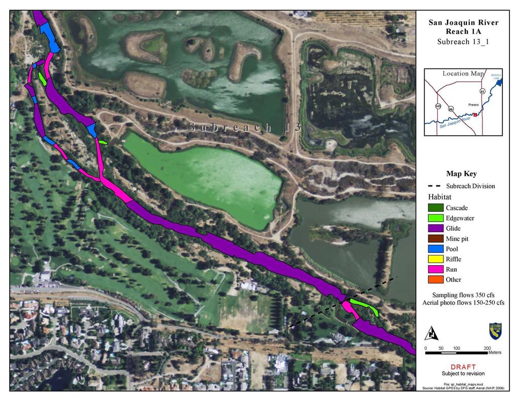
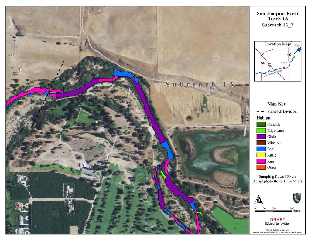
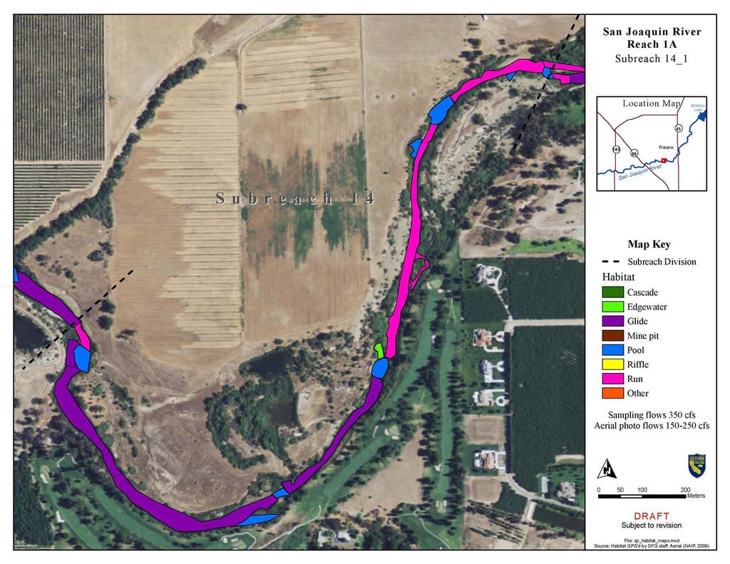
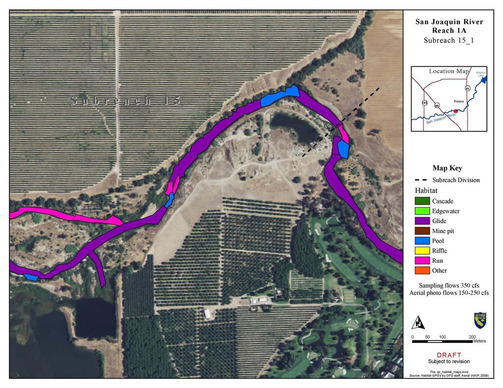
3 1.0 Introduction Introduction The following appendix includes a report provided by the California Department of Fish and Game, Summary of Pilot Study for Reach 1A Meso-Habitat Monitoring during the fall Interim Flow Period for the San Joaquin Restoration Program. This report details monitoring methodology and results from monitoring surveys conducted during the fall Water Year 2010 Interim Flows period. Macrohabitat Surveys Draft Appendix G-1 March 2010
4 San Joaquin River Restoration Program 1 This page left blank intentionally.
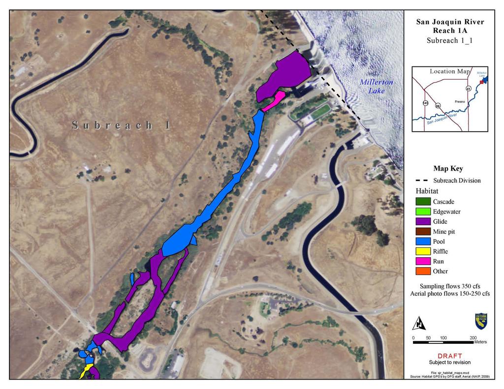
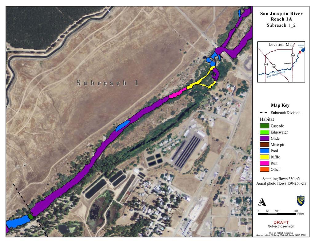
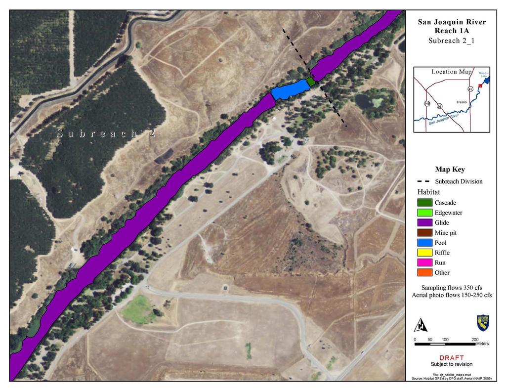
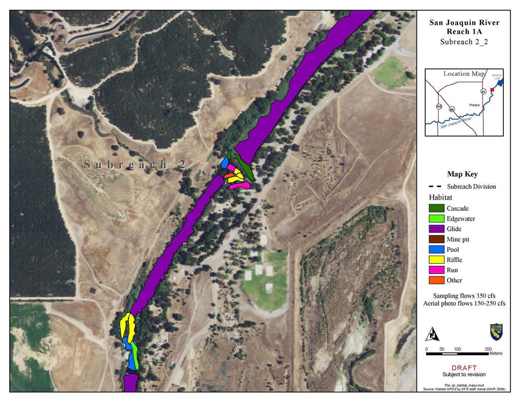
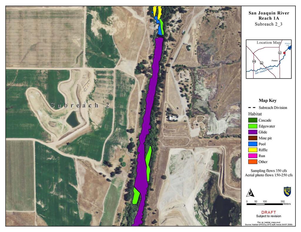
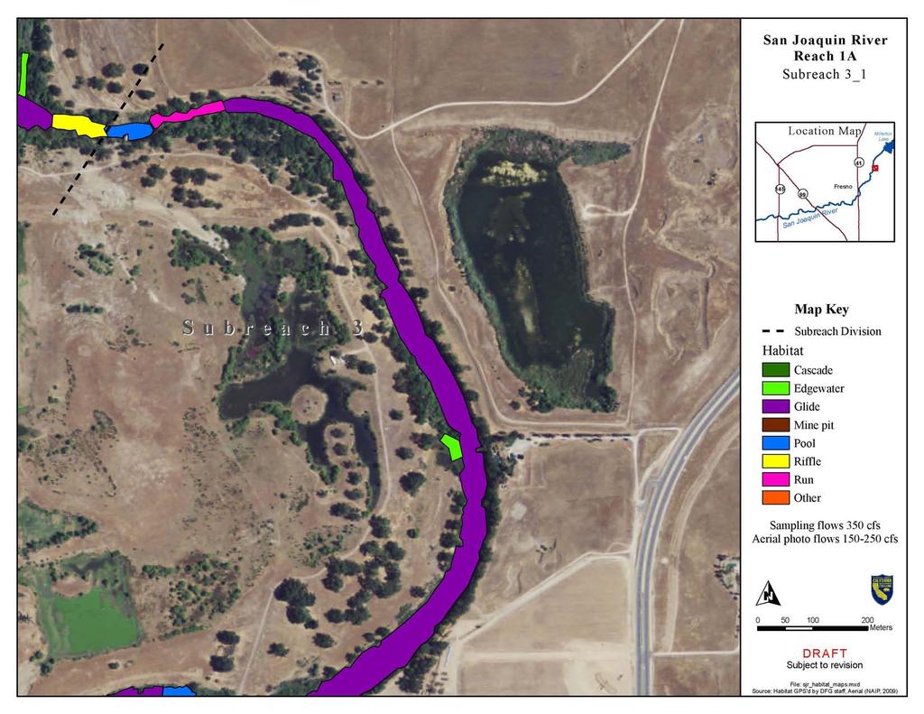
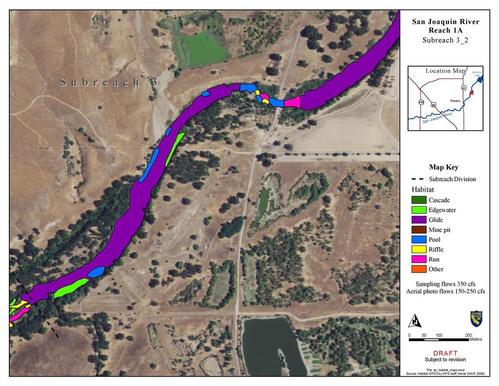
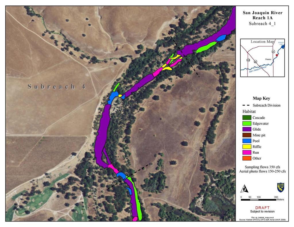
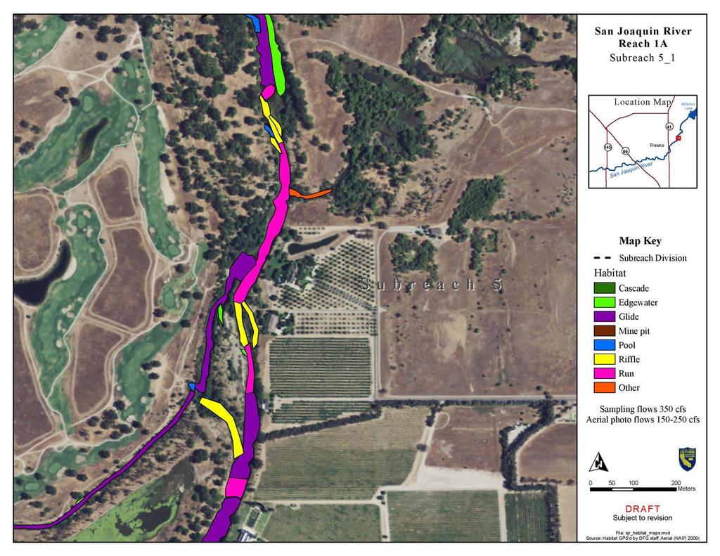
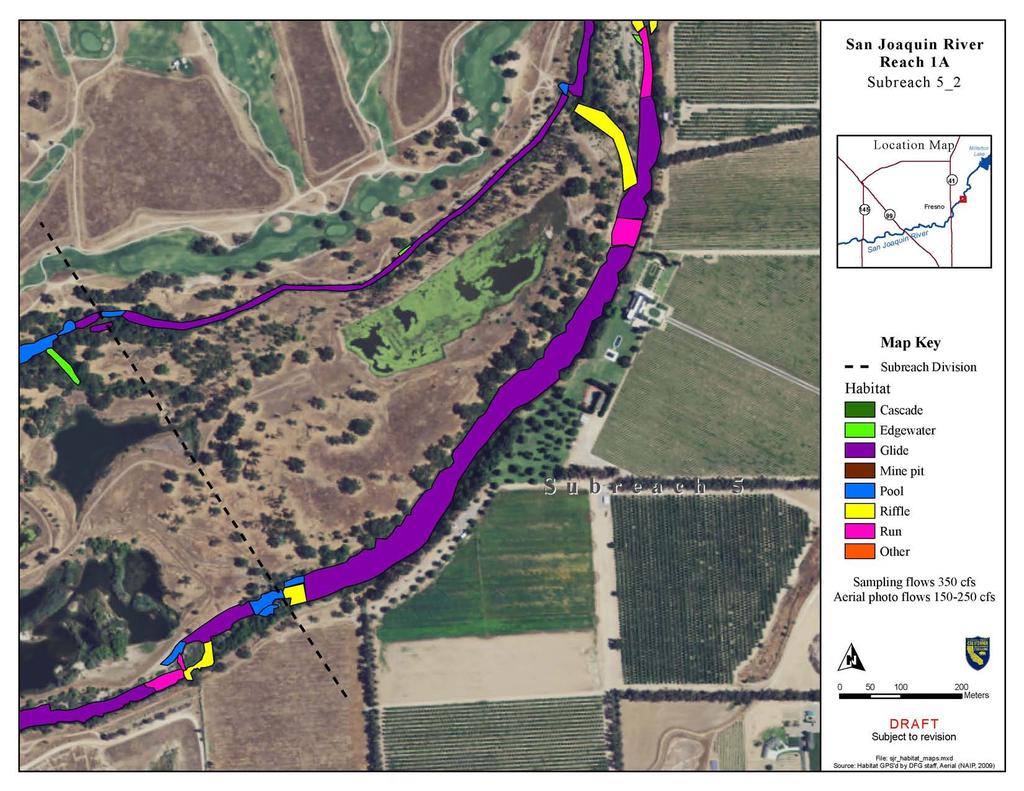
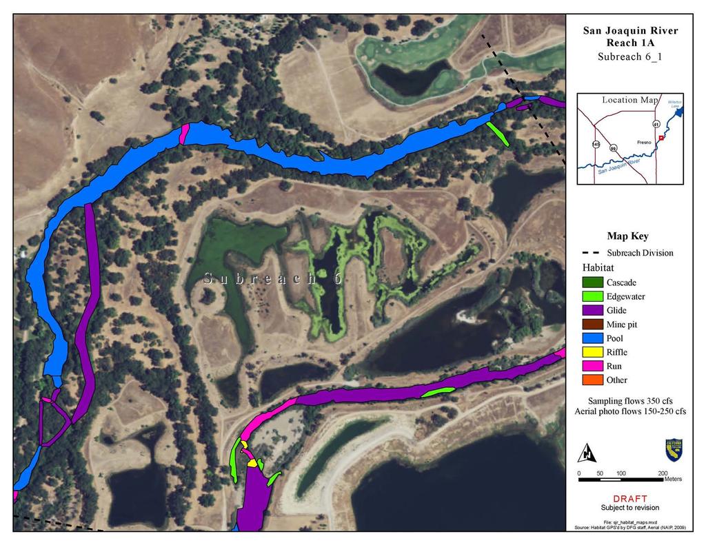
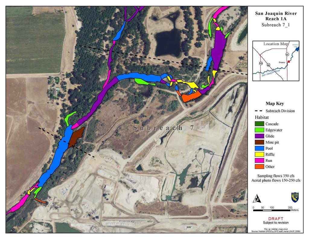
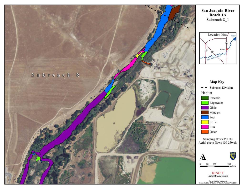
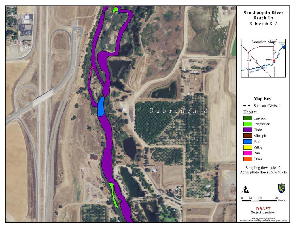
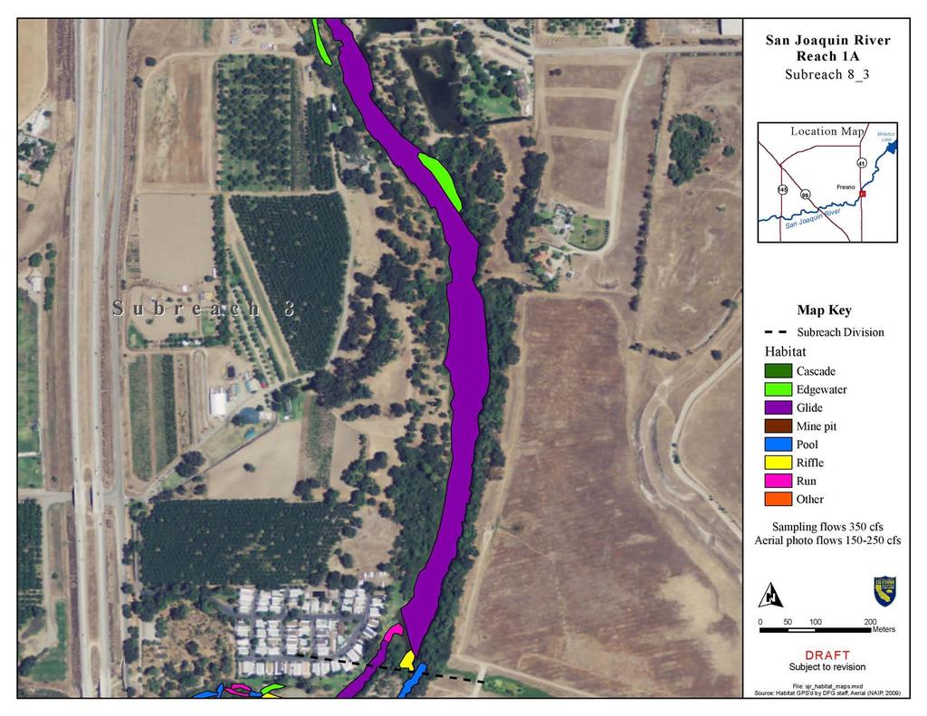
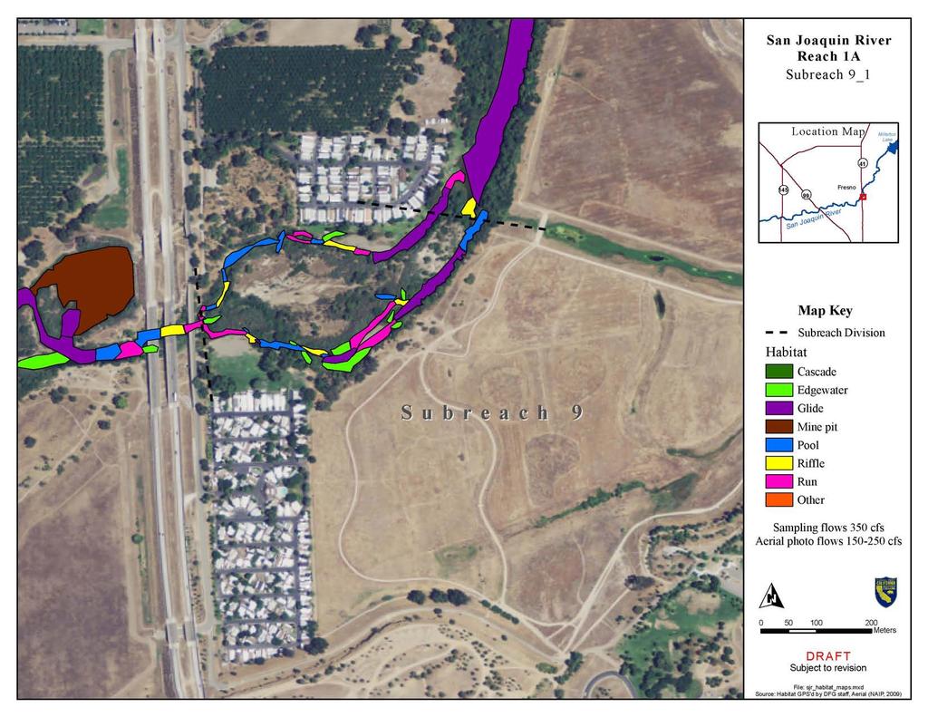
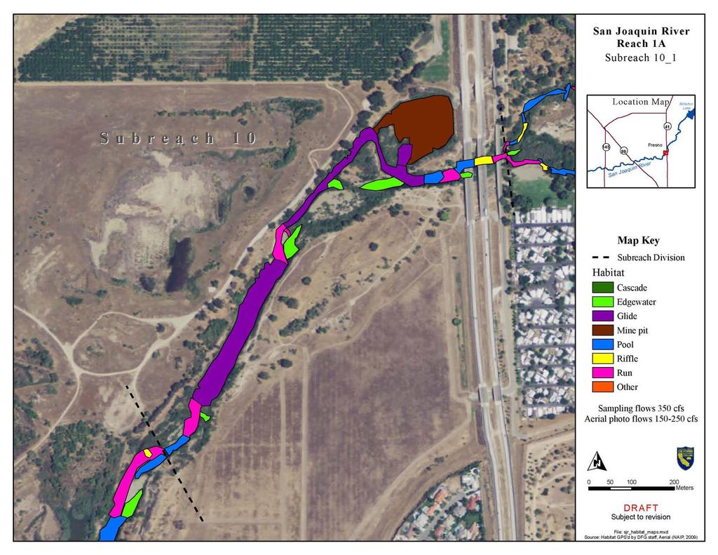
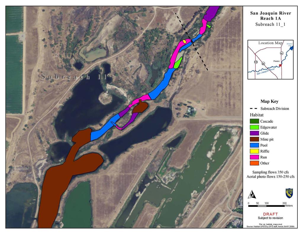
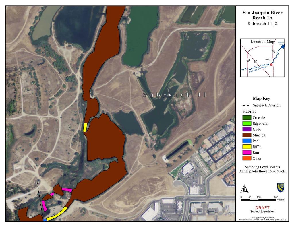
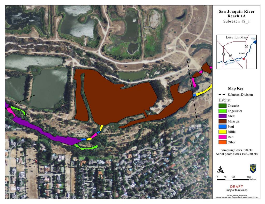
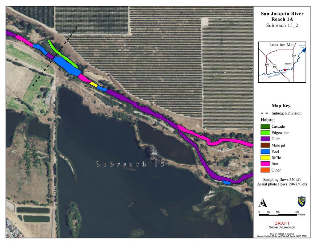
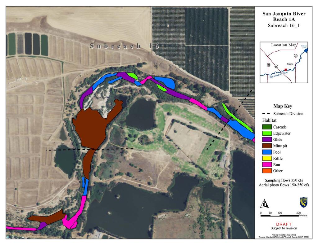
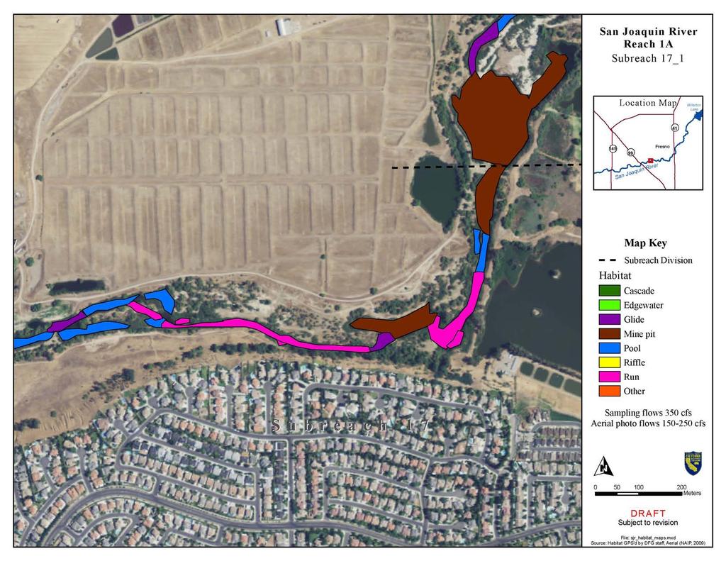
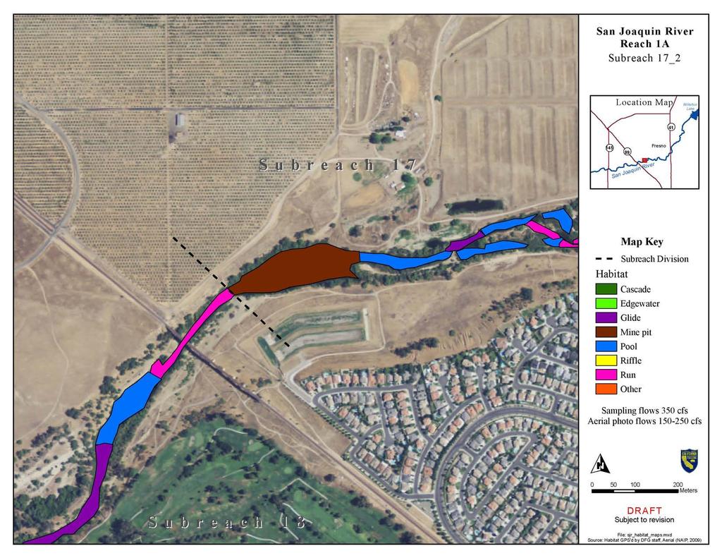
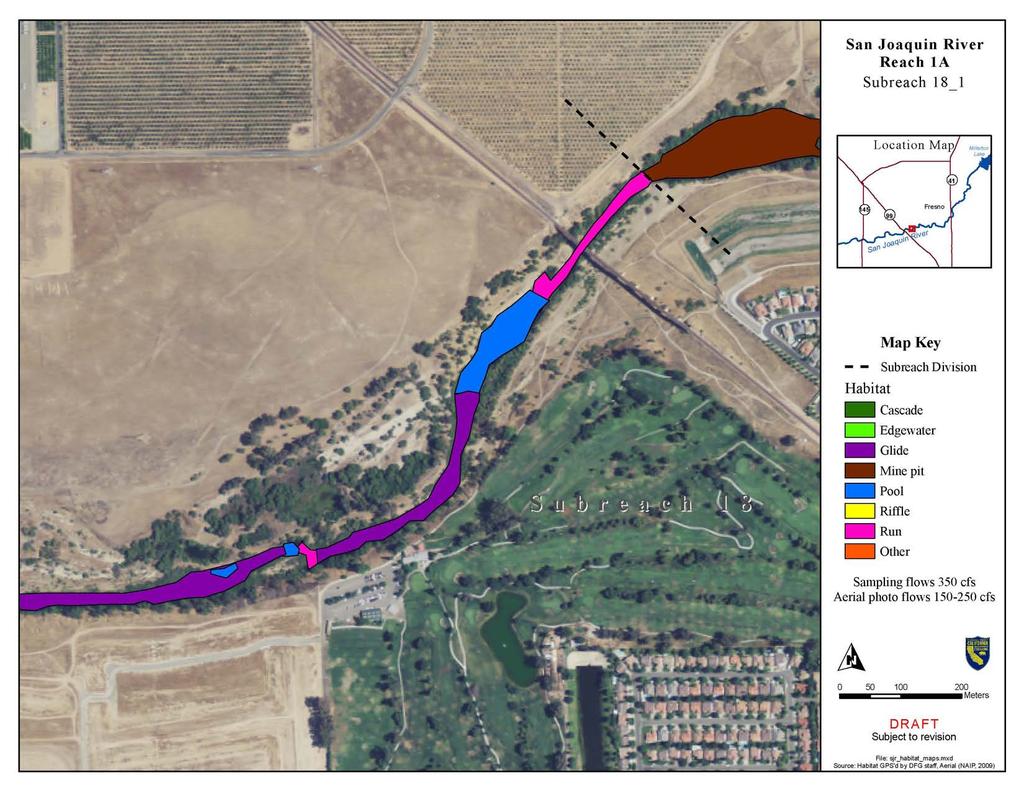
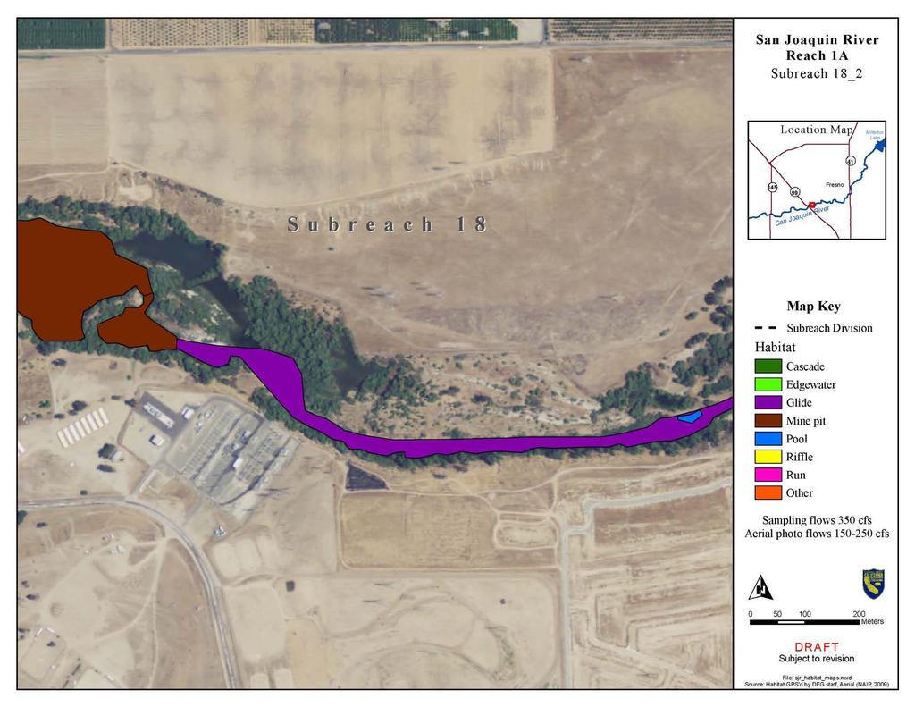
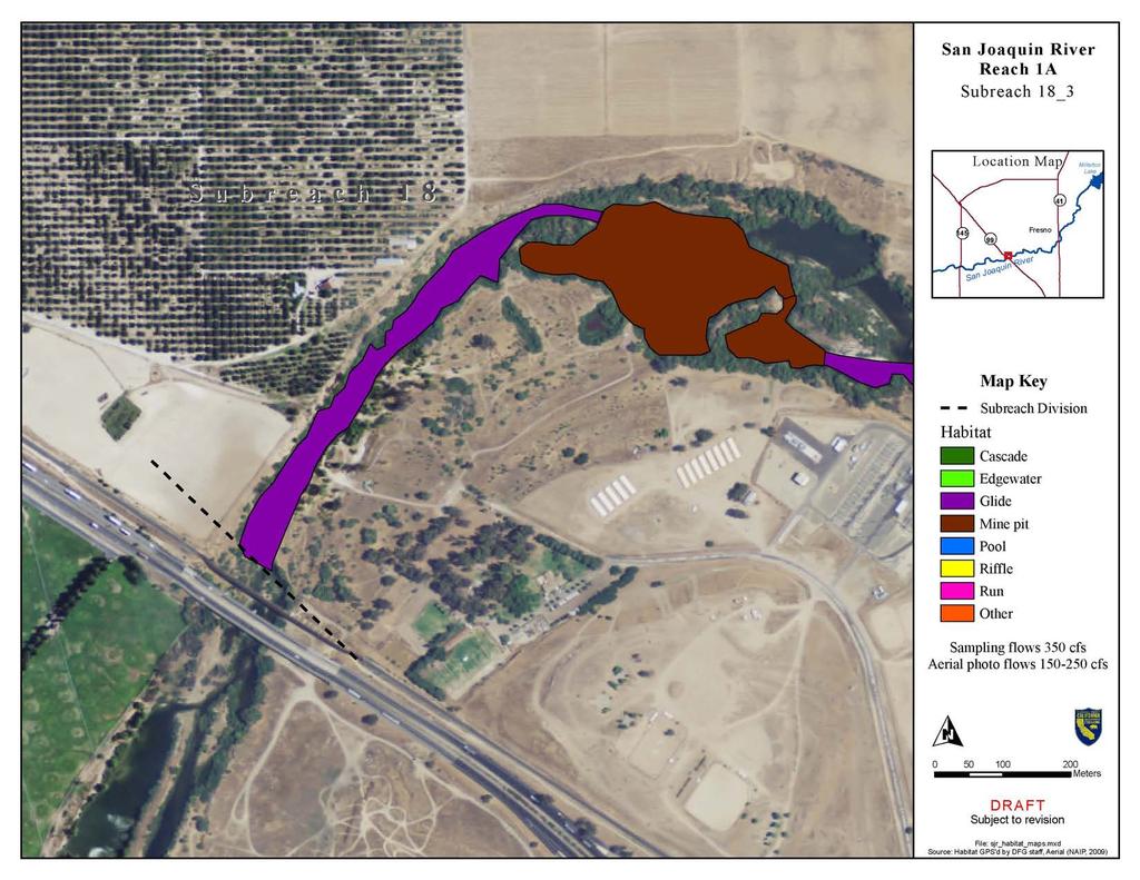
5 Summary of Pilot Study for Reach 1A Meso Habitat Monitoring during the fall Interim Flow Period Eric Guzman, California Department of Fish and Game, San Joaquin River Restoration Fisheries Management Work Group Introduction. This report summarizes the San Joaquin River (SJR) Meso Habitat Monitoring Pilot Study related to the 2009 Interim Flow Period (IFP) for the San Joaquin River Restoration Program (SJRRP). The IFP started October 1, 2009 and ended November 20, See Table 1 for time periods of flow release magnitudes and volumes. Meso habitat monitoring consisted of mapping and characterizing SJR Habitat Units (HU) from Friant Dam to the end of Reach 1A (Highway 99). Meso habitat mapping began on October 1, 2009 and ended October 31, Recent aerial photographs were used to refine and expand GPS data points into map polygons in GIS depicting habitat units. The aerial photographs were estimated to be taken at cfs (cubic feet per second) releases from Friant Dam (Appendix A: SJR Habitat Maps). This report summarizes the data collection methods, periods of data collection, San Joaquin River (SJR) conditions. The purpose of this habitat monitoring is to document the longitudinal distribution of HU in an effort to plan for other studies (microhabitat, holding, and spawning) HU are relatively homogenous areas and are coarse in scale. Data collected for this Pilot Study will be used to refine and inform design and data collection activities and will be used to determine sampling locations for subsequent microhabitat measurements. All data contained within this report and appendices are preliminary and subject to revision. Table 1: IFP Flow Release Magnitudes and Volumes Time window Riparian Release Interim Flow Release Total Friant Dam Release Oct 1 31, cfs 190 cfs 350 cfs Nov 1 10, cfs 570 cfs 700 cfs Nov 11 20, cfs 230 cfs 350 cfs Total Release Volume: 14,800 ac ft 27,500 ac ft 42,300 ac ft Methods. Crews of 2 6 individuals from the Department of Fish and Game floated the river in kayaks or waded in shallow habitats while taking measurements at each habitat unit. HU were identified utilizing a classification system based upon those developed by Flosi and Reynolds (1998) and P.A. Bisson, et al. (1982). A main HU was identified when its length was equal to or greater than the width of the river. A
6 side channel HU (sub habitat adjacent to the main channel HU) was identified when its length was equal to or greater than half the width of the river. If the area being sampled appeared to have some features that were not entirely consistent with the dominant HU but did not meet the above criteria (i.e. its channel length was less than the width), that area was lumped in with the dominant mid channel HU. Table 2 displays all of the potential habitat types that were considered likely to be present in the study area. Table 2: Potential Habitat Unit Types Within The SJR Restoration Area RIFFLE Low Gradient Riffle High Gradient Riffle (LGR) (HGR) CASCADE Cascade Bedrock Sheet (CAS) (BRS) FLATWATER Pocket Water Glide Run Step Run Edgewater (POW) (GLD) (RUN) (SRN) (EDW)* MAIN CHANNEL POOL Trench Pool Mid Channel Pool Channel Confluence Pool Step Pool (TRP) (MCP) (CCP) (STP) SCOUR POOL Corner Pool (CRP)* L. Scour Pool Log Enhanced (LSL)* L. Scour Pool Root Wad Enhanced (LSR)*
7 L. Scour Pool Bedrock Formed (LSBk) * L. Scour Pool Boulder Formed (LSBo)* Plunge Pool (PLP) BACKWATER POOLS Secondary Channel Pool Backwater Pool Boulder Formed Backwater Pool Root Wad Formed Backwater Pool Log Formed Dammed Pool (SCP)* (BPB)* (BPR)* (BPL)* (DPL) ADDITIONAL UNIT DESIGNATIONS Dry Culvert Not Surveyed Not Surveyed due to a marsh In Channel Mine Pit Captured Mine Pit (DRY) (CUL) (NS) (MAR) (ICMP) (CMP) * indicate side HU type Visual estimation of flow, depth, and substrate were criteria used to identify and delineate a HU. HU are discrete characterizations for relative estimations of continuous conditions and therefore difficult to quantify using qualitative criteria. It is common for smaller habitat patches to be present, especially in reaches with more complex channel features (riffle, run, pools complex), therefore, it was difficult to be objective and accurate when delineating HU boundary points. The complex transitional nature of channel features does not easily accommodate subjective decisions made by a group of surveyors. When a defined HU was encountered, average wetted width, length, mean depth, and HU type were recorded. The boundaries of each HU were recorded using a Garmin E Trex Global Positioning System (GPS) and a range finder. A range finder was used to measure wetted widths and shorter HU lengths (typically runs, riffles, and pools). GPS points were used to measure longer HU lengths (typically long glides and large mine pits). GPS points were recorded at three equidistant points (top, middle, and bottom) throughout the length of the HU when the length of the unit was shorter than 8 times the average wetted width of the river. When habitat units were longer than 8 times the average wetted width of the river, points were recorded at five equidistant points (top, top/middle, middle, middle/bottom, and bottom) throughout the length of the HU. To better capture the variation in widths, GPS points were taken at more locations (top/middle, middle, and middle/bottom) when bends were
8 located within a HU sampled. Depth was measured using several methods, but a meter stick was found to be more effective in shallower units and a SpeedTech SM 5 Depthmate Portable Sounder and Depth Meter was more effective in deeper water. Discharge was recorded based upon the CDEC station records closest to the survey point (i.e. upstream of Hwy 41 bridge sites recorded Mil station data). Polygons were created on aerial photographs taken in the summer of 2009 (Appendix A: SJR Habitat Maps). Width measurements were averaged and used to ground truth GIS polygon to obtain a more accurate measure of HU area. The starting and ending GPS points from the survey provided the upstream and down stream boundary. The polygon was connected by following the wetted edge of the river on either the left or right bank and connecting the upstream to the downstream boundary. The area from each HU was calculated from the GIS polygons. Reach 1A was divided into 18 sub reaches. Sub reach 1A.1 was the first ten HU encountered in Reach 1A, the next ten were 1A.2. This system continued through the entire Reach and ended at sub reach 1A.18. Each HU (including main and side channel) within each sub reach were identified and recorded. A photograph was also taken, looking downstream and is recorded on the data sheet as the corresponding photo number displayed on the camera and the camera ID. Side habitats (such as edgewater, backwater, etc.) were determined to be distinct HU, and were recorded as distinct features associated within the HU. Likewise, if a secondary channel HU had side channel habitat, then the side channel habitat would be recorded similarly. If the river was divided into two or more channels (braided channels), the dominant channel (the one with the highest discharge) was assigned the main HU number. Each secondary channel habitat was given a separate HU identifier (provided it met the minimum length criteria for side and main channel HU). Additionally, some secondary channels contained multiple HU before reconnecting with the main channel and were recorded as well. Mine pits that have the river flowing directly through them were classified as in channel mine pits and were included in the survey. Mine pits that have connectivity to the river but the main channel does not flow through them were classified as off channel mine pits and were not included in the survey. A GPS point was taken at the entrance point of off channel mine pits. Mine pits that may be adjacent to the SJR but do not have connectivity were not identified in this study. Results. Results from this SJR Meso Habitat Monitoring Pilot Study indicate that in Reach 1A [Friant Dam (RM 267) to Highway 99 Bridge (RM 243)] 378 distinct habitat units were encountered (see Table 3: Reach 1A Habitat Units). There were 21 different habitat types that include 179 main channel habitat units, 93 side habitat units, and 108 secondary channel habitat units (see Table 4: Habitat Units by Sub Reach). Pools were the most frequently encountered habitat type ( 27.8%), whereas glides consume most (54.0%) of the area of the river that was surveyed. A bar graph showing distribution of habitat types is provided in Figure 1.
9 Table 3: Reach 1A Habitat Units Type of Habitat Quantity % Encountered Total Area (sq m) % Total Area Total Length (m) % Total Length Pool % 222, % 8, % Run % 132, % 8, % Glide % 988, % 28, % Edgewater % 54, % 3, % Riffle % 37, % 2, % Mine Pit % 386, % 3, % Other 4 1.1% 5, % % Cascade 3 0.8% 2, % % Pocket Water 1 0.3% % % Total 378 1,829, ,541.9
10 Table 4: Habitat Units by Sub Reach Reach Number of Main Channel Habitat Units Number of Side Habitat Units Number of Secondary Channel Habitat Units Combined Total of Habitat Units 1A A A A A A A A A A A A A A A A A A TOTAL
11 Figure 1: Distribution of Habitat Types Distribution of Habitat Types 60.0% 50.0% 40.0% 30.0% 20.0% 10.0% 0.0% Pocket Water Cascade Other Mine Pit Riffle Edgewater Glide Run Pool % Encountered % Toatal Area % Total Length Types of Habitat Literature Cited Bisson, P.A., J.L. Nielsen, R.A. Palmson, and L.E. Grove A system of naming habitat types in small streams with examples of habitat utilization by salmonids during low stream flow. Symposium on acquisition and utilization of aquatic habitat inventory information. Western Division, American Fisheries Society. Bethesda, Maryland. Flosi, G., and F.L. Reynolds California Salmonid Stream Habitat Restoration Manual. California Department of Fish and Game, Technical Report, Sacramento.
12
13
14
15
16

17
18
19
20
21
22
23
24
25
26
27
28
29
30
31
32
33
34
35
36
37
38
39
40
41
42
43
Restoration Goals TFG Meeting. Agenda
 San Joaquin River Restoration Program Restoration Goals TFG Meeting Reach 2B Update April 28, 2010 Agenda 1. Introductions 2. Program Restoration Goal Context 3. Program Update a) Interim Flows b) EIS/EIR
STREAM INVENTORY REPORT PENNINGTON CREEK
 STREAM INVENTORY REPORT PENNINGTON CREEK INTRODUCTION A stream inventory was conducted during the summer of 2001 on Pennington Creek. The survey began at the confluence with Chorro Creek and extended up
MORRO BAY WATERSHED STEELHEAD RESTORATION PLANNING PROJECT
 MORRO BAY WATERSHED STEELHEAD RESTORATION PLANNING PROJECT STREAM INVENTORY REPORT DAIRY CREEK, 2001 Prepared to: Coastal San Luis Resource Conservation District MORRO BAY WATERSHED STEELHEAD RESTORATION
SALMONID HABITAT ASSESSMENT UPPER MILLER CREEK
 SALMONID HABITAT ASSESSMENT UPPER MILLER CREEK GRADY RANCH, MARIN COUNTY, CALIFORNIA July 2011 Prepared for: Skywalker Properties Ltd. 5858 Lucas Valley Road Nicasio, California 94946 Prepared by: WRA,
YUBA COUNTY WATER AGENCY
 YUBA COUNTY WATER AGENCY Representative Site Selection Above Englebright Reservoir Stream Fish, Aquatic BMI, Aquatic Mollusks Yuba County Water Agency Yuba River Development Project FERC Project No. 2246
DETAILED DESCRIPTION OF STREAM CONDITIONS AND HABITAT TYPES IN REACH 4, REACH 5 AND REACH 6.
 DETAILED DESCRIPTION OF STREAM CONDITIONS AND HABITAT TYPES IN REACH 4, REACH 5 AND REACH 6. The Eklutna River was divided into study reaches (figure 1) prior to this site visit. Prominent geologic or
ODFW AQUATIC INVENTORY PROJECT OREGON PLAN FOR SALMON & WATERSHEDS STREAM RESTORATION HABITAT REPORT
 ODFW AQUATIC INVENTORY PROJECT OREGON PLAN FOR SALMON & WATERSHEDS STREAM RESTORATION HABITAT REPORT STREAM: BASIN: SURVEY TYPE: Munson Creek (NC-342) Tillamook River Post-Tx DATE: February 2, 28 SURVEY
San Joaquin River Tributary Sediment Transport and Geomorphology Study
 Study 22 San Joaquin River Tributary Sediment Transport and Geomorphology Study Public Draft 2013 Monitoring and Analysis Plan September 2012 22.0 San Joaquin River Tributary Sediment Transport and Geomorphology
Influence of Paleochannels on Seepage
 Study 4 Influence of Paleochannels on Seepage Public Draft 2014 Monitoring and Analysis Plan September 2013 August 2012 Influence of Paleochannels on Seepage 1. Statement of Need Historical maps, aerial
ODFW AQUATIC INVENTORY PROJECT OREGON PLAN FOR SALMON & WATERSHEDS STREAM RESTORATION HABITAT REPORT
 ODFW AQUATIC INVENTORY PROJECT OREGON PLAN FOR SALMON & WATERSHEDS STREAM RESTORATION HABITAT REPORT STREAM: BASIN: SURVEY TYPE: South Sister Creek (U-5) Smith River Pre-Tx DATE: January 7, 4 SURVEY CREW:
Vermont Stream Geomorphic Assessment. Appendix J. Vermont Regional Hydraulic Geometry Curves
 Vermont Stream Geomorphic Assessment Appendix J Vermont Regional Hydraulic Geometry Curves River Management Program Vermont Water Quality Division November, 2001 Natural Resources - J0 - VT Agency of Background
ODFW AQUATIC INVENTORY PROJECT RESTORATION MONITORING STREAM HABITAT REPORT. Peggy Kavanagh, Trevan Cornwell TOLEDO SOUTH Coast Range Lora Tennant
 ODFW AQUATIC INVENTORY PROJECT RESTORATION MONITORING STREAM HABITAT REPORT STREAM: GCG: 2-MC SITE ID: 489 BASIN: YAQUINA TREATMENT DATE: 24 SURVEY DATE: 2/27/24 SURVEY CREW: USGS MAPS: ECOREGION: REPORT
Hydraulic and Sediment Transport Modeling Strategy
 Appendix B Hydraulic and Sediment Transport Modeling Strategy May 2014 Technical Memorandum Channel Capacity Report January 2015 San Joaquin River Restoration Program Hydraulic and Sediment Transport Modeling
Why Geomorphology for Fish Passage
 Channel Morphology - Stream Crossing Interactions An Overview Michael Love Michael Love & Associates mlove@h2odesigns.com (707) 476-8938 Why Geomorphology for Fish Passage 1. Understand the Scale of the
Little Blackfoot TPA 2009 Sediment and Habitat Assessment QAQC Review March 9, 2010
 Little Blackfoot TPA 2009 Sediment and Habitat Assessment QAQC Review March 9, 2010 1.0 PROJECT OVERVIEW Sediment and habitat monitoring in the Little Blackfoot TPA was conducted in July of 2009 as outlined
Rosgen Classification Unnamed Creek South of Dunka Road
 Rosgen Classification Unnamed Creek South of Dunka Road Prepared for Poly Met Mining Inc. September 2013 Rosgen Classification Unnamed Creek South of Dunka Road Prepared for Poly Met Mining Inc. September
ADDRESSING GEOMORPHIC AND HYDRAULIC CONTROLS IN OFF-CHANNEL HABITAT DESIGN
 ADDRESSING GEOMORPHIC AND HYDRAULIC CONTROLS IN OFF-CHANNEL HABITAT DESIGN Conor Shea - Hydrologist U.S. Fish and Wildlife Service Conservation Partnerships Program Arcata, CA Learning Objectives Examine
Estimated Sediment Volume: Bridge Street Dam Impoundment, Royal River, Yarmouth, Maine
 University of Southern Maine USM Digital Commons Publications Casco Bay Estuary Partnership (CBEP) 2015 Estimated Sediment Volume: Bridge Street Dam Impoundment, Royal River, Yarmouth, Maine Stantec Follow
Spring Run Spawning Habitat Assessment Sediment Mobility
 Study 47 Spring Run Spawning Habitat Assessment Sediment Mobility Final 2015 Monitoring and Analysis Plan January 2015 1.0 Spring Run Spawning Habitat Assessment Sediment Mobility Theme(s): Flow management
SRH Group Facies Mapping
 Study 37 SRH Group Facies Mapping Public Draft 2014 Monitoring and Analysis Plan September 2013 Project Management Plan (PMP) Job Name: San Joaquin River Restoration Program Date Submitted: 8-1-13 Hydraulic
PolyMet NorthMet Project
 RS 26 Draft-01 December 8, 2005 RS26 Partridge River Level 1 Rosgen Geomorphic Survey Rosgen Classification Partridge River from Headwaters to Colby Lake Prepared for PolyMet NorthMet Project December
Gravel Extraction Annual Monitoring Report
 P.O. Box 712 Scotia, CA 95565 Phone (707) 764-4392 Fax (707) 764-4118 www.hrcllc.com Gravel Extraction Annual Monitoring Report Middle Reach of the Eel River Humboldt County CA Encompassing gravel bars:
Fish Passage at Road Crossings
 Fish Passage at Road Crossings 1 Crossing Design Workshop Outline 1:00 to 2:00 Intro, Design Overview, Channel Width 2:00 to 2:15 Break 2:15 to 3:15 No-Slope, Stream Simulation Design 3:15 to 3:30 Break
REACH 1 T37S-R14W-S07NW
 OREGON DEPT. FISH AND WILDLIFE HABITAT INVENTORY Report Date: 3//3 Survey Date: 7/3/ REACH T37S-R4W-S7NW REACH Valley and Channel Summary Narrow Valley Floor Steep V-shape Moderate V-shape Open V-shape
17-20 November 2007 Incidental Take Monitoring Methodology and Results
 Sample Site Selection Protocol 17-20 November 2007 Incidental Take Monitoring Methodology and Results On 16 November 2007, the U.S. Fish and Wildlife Service (USFWS) provided the USACE Mobile District
Habitat Assessment. Peggy Compton UW-Extension Water Action Volunteers Program Coordinator
 Habitat Assessment Peggy Compton UW-Extension Water Action Volunteers Program Coordinator Adapted from a presentation by Jean Unmuth, Water Quality Biologist, WI DNR dnr.wi.gov www.uwex.edu erc.cals.wisc.edu
UPPER COSUMNES RIVER FLOOD MAPPING
 UPPER COSUMNES RIVER FLOOD MAPPING DRAFT BASIC DATA NARRATIVE FLOOD INSURANCE STUDY SACRAMENTO COUTY, CALIFORNIA Community No. 060262 November 2008 Prepared By: CIVIL ENGINEERING SOLUTIONS, INC. 1325 Howe
ODFW AQUATIC INVENTORY PROJECT STREAM REPORT
 ODFW AQUATIC INVENTORY PROJECT STREAM REPORT STREAM: BASIN: Basin Creek Willow Creek DATE: July 9 3, 9 SURVEY CREW: REPORT PREPARED BY: USGS MAPS: ECOREGION: Nicole Bushey / Emily Zimmermann Staci Stein
!"#$%&&'()*+#$%(,-./0*)%(!
*+#$%(,-./0*)%(!") 8:30 Sign in Hoosic River Revival Coalition!"#$%&&'()*+#$%(,-./0*)%(! 12-#30+4/#"5-(60 9:00 Welcome and Introductions 9:15 Goals for Today s Program: A Description of the Planning Process 9:30 First Session:
8:30 Sign in Hoosic River Revival Coalition!"#$%&&'()*+#$%(,-./0*)%(! 12-#30+4/#"5-(60 9:00 Welcome and Introductions 9:15 Goals for Today s Program: A Description of the Planning Process 9:30 First Session:
CR AAO Bridge. Dead River Flood & Natural Channel Design. Mitch Koetje Water Resources Division UP District
 CR AAO Bridge Dead River Flood & Natural Channel Design Mitch Koetje Water Resources Division UP District Old County Road AAO Bridge Map courtesy of Marquette County Silver Lake Basin McClure Basin
ODFW AQUATIC INVENTORY PROJECT STREAM REPORT
 ODFW AQUATIC INVENTORY PROJECT STREAM REPORT STREAM: BASIN: South Fork Mill Creek Mill Creek / Columbia River DATES: September 7 9, 5 SURVEY CREW: REPORT PREPARED BY: Brian Bangs / LaNoah Babcock Staci
May Creek Canyon LWD Stream Restoration Project. Helicopter Placement of LWD in an Urban Stream. By Kathryn Neal, P.E.
 Helicopter Placement of LWD in an Urban Stream By Kathryn Neal, P.E. May Creek Canyon LWD Stream Restoration Project By Kathryn Neal, P.E. Project proponents: King County City of Renton City of Newcastle
Addressing the Impact of Road-Stream Crossing Structures on the Movement of Aquatic Organisms
 Scott Jackson University of Massachusetts Amherst Addressing the Impact of Road-Stream Crossing Structures on the Movement of Aquatic Organisms Dams Sub-standard Culverts Excessive Velocities Inlet Drop
1.0 Appendix. Appendix A In-stream LWD Data Collection Sheet In Stream LWD Data Collection Stream Site: Coordinates:x y Crew: Date: Dia-4.
 1.0 Appendix Appendix A In-stream LWD Data Collection Sheet In Stream LWD Data Collection Stream Site: Coordinates:x y Crew: Date: Shot ID-1 Shot Id-2 Shot Id-3 Shot Id-4 Tagid LWD Criteria Dia-1 (cm)
60 PERCENT DESIGN REPORT HABITAT RESTORATION OF THE CHELAN RIVER REACH 4 AND TAILRACE
 60 PERCENT DESIGN REPORT HABITAT RESTORATION OF THE CHELAN RIVER REACH 4 AND TAILRACE Prepared for Public Utility District Number 1 of Chelan County 327 North Wenatchee Avenue Wenatchee, Washington 98801
REDWOOD VALLEY SUBAREA
 Independent Science Review Panel Conceptual Model of Watershed Hydrology, Surface Water and Groundwater Interactions and Stream Ecology for the Russian River Watershed Appendices A-1 APPENDIX A A-2 REDWOOD
7.1 COMPONENTS OF THE HABITAT CHARACTERIZATION 7.2 HABITAT SAMPLING LOCATIONS WITHIN THE SAMPLING REACH 7.3 LOGISTICS AND WORK FLOW 7
 7 PHYSICAL HABITAT CHARACTERIZATION...97 7.1 COMPONENTS OF THE HABITAT CHARACTERIZATION...101 7.2 HABITAT SAMPLING LOCATIONS WITHIN THE SAMPLING REACH...103 7.3 LOGISTICS AND WORK FLOW...105 7.4 THALWEG
Reach 1A Spawning Area Bed Mobility
 Study Reach 1A Spawning Area Bed Mobility Public Draft 0 Monitoring and Analysis Plan September 0 1 1 1 1 1 1 0 1 0 1.0 Reach 1A Spawning Area Bed Mobility.1 Statement of Need The Problem Statement for
River Nith restoration, cbec UK Ltd, October 2013 APPENDIX A
 APPENDIX A FLUVIAL AUDIT METHOD STATEMENT Fluvial Audit Methodology INTRODUCTION The procedure used to characterize the geomorphic and sedimentary regimes of the River Till is an adaptation of the Fluvial
STUDY PERFORMANCE REPORT
 STUDY PERFORMANCE REPORT State: Michigan Project No.: F-80-R-8 Study No.: 230702 Title: Effects of sediment traps on Michigan river channels Period Covered: October 1, 2006 to September 30, 2007 Study
Sessom Creek Sand Bar Removal HCP Task 5.4.6
 Sessom Creek Sand Bar Removal HCP Task 5.4.6 Prepared by: Dr. Thomas Hardy Texas State University Dr. Nolan Raphelt Texas Water Development Board January 6, 2013 DRAFT 1 Introduction The confluence of
Appendix 12J Winter-Run Chinook Salmon Life Cycle Modeling
 Appendix 12J Winter-Run Chinook Salmon Life Cycle Modeling Line items and numbers identified or noted as No Action Alternative represent the Existing Conditions/No Project/No Action Condition (described
DISCUSSION PURPOSES ONLY C A L I F O R N I A S T A T E L A N D S C O M M I S S I O N
 C A L I F O R N I A S T A T E L A N D S C O M M I S S I O N SAN JOAQUIN RIVER REACH 2B OVERVIEW OF THE CALIFORNIA STATE LANDS COMMISSION ADMINISTRATIVE MAPS PRESENTATION Water Boundary Principles Best
Gravel Transport Study Report for Energy Northwest's Packwood Lake Hydroelectric Project FERC No Lewis County, Washington
 Final Gravel Transport Study Report for Energy Northwest's Packwood Lake Hydroelectric Project FERC No. 2244 Lewis County, Washington Submitted to P.O. Box 968 Richland, Washington 99352-0968 Submitted
SACRAMENTO MUNICIPAL UTILITY DISTRICT UPPER AMERICAN RIVER PROJECT (FERC Project No. 2101) and
 and") SACRAMENTO MUNICIPAL UTILITY DISTRICT UPPER AMERICAN RIVER PROJECT (FERC Project No. 2101) and PACIFIC GAS AND ELECTRIC COMPANY CHILI BAR PROJECT (FERC Project No. 2155) STREAM HABITAT MAPPING TECHNICAL
SACRAMENTO MUNICIPAL UTILITY DISTRICT UPPER AMERICAN RIVER PROJECT (FERC Project No. 2101) and PACIFIC GAS AND ELECTRIC COMPANY CHILI BAR PROJECT (FERC Project No. 2155) STREAM HABITAT MAPPING TECHNICAL
SCOPE OF PRESENTATION STREAM DYNAMICS, CHANNEL RESTORATION PLANS, & SEDIMENT TRANSPORT ANALYSES IN RELATION TO RESTORATION PLANS
 DESIGN METHODS B: SEDIMENT TRANSPORT PROCESSES FOR STREAM RESTORATION DESIGN PETER KLINGEMAN OREGON STATE UNIVERSITY CIVIL ENGINEERING DEPT., CORVALLIS 2 ND ANNUAL NORTHWEST STREAM RESTORATION DESIGN SYMPOSIUM
Technical Memorandum. To: From: Copies: Date: 10/19/2017. Subject: Project No.: Greg Laird, Courtney Moore. Kevin Pilgrim and Travis Stroth
 Technical Memorandum To: From: Greg Laird, Courtney Moore Kevin Pilgrim and Travis Stroth 5777 Central Avenue Suite 228 Boulder, CO 80301 www.otak.com Copies: [Electronic submittal] Date: 10/19/2017 Subject:
Important Copyright Information
 Important Copyright Information The following content is provided for educational purposes by the workshop presenter. This content may or may not have been peer reviewed. Information, opinions and recommendations
Technical Memorandum No Sediment Model
 Pajaro River Watershed Study in association with Technical Memorandum No. 1.2.9 Sediment Model Task: Development of Sediment Model To: PRWFPA Staff Working Group Prepared by: Gregory Morris and Elsie Parrilla
Woodstock, Route 26 Stream Relocation Project
 MAINE DEPARTMENT OF TRANSPORTATION 2006 POST - CONSTRUCTION MONITORING REPORT: Woodstock, Route 26 Stream Relocation Project Year 1 of 5 Compensation for the Woodstock, Route 26 Highway Reconstruction
PENNSYLVANIA DEPARTMENT OF TRANSPORTATION ENGINEERING DISTRICT 3-0
 PENNSYLVANIA DEPARTMENT OF TRANSPORTATION ENGINEERING DISTRICT 3-0 LYCOMING COUNTY S.R.15, SECTION C41 FINAL HYDROLOGIC AND HYDRAULIC REPORT STEAM VALLEY RUN STREAM RELOCATION DATE: June, 2006 REVISED:
Appendix I Feasibility Study for Vernal Pool and Swale Complex Mapping
 Feasibility Study for Vernal Pool and Swale Complex Mapping This page intentionally left blank. 0 0 0 FEASIBILITY STUDY BY GIC AND SAIC FOR MAPPING VERNAL SWALE COMPLEX AND VERNAL POOLS AND THE RESOLUTION
Folsom Dam Water Control Manual Update Joint Federal Project, Folsom Dam
 Folsom Dam Water Control Manual Update Joint Federal Project, Folsom Dam Public Workshop May 25, 2016 Sacramento Library Galleria 828 I Street, Sacramento, CA US Army Corps of Engineers BUILDING STRONG
Case Study 8. North Fork Nooksack River In-channel Project
 Case Study 8 Project Overview The North Fork Nooksack In-channel project was developed cooperatively between the USDA Forest Service and the Nooksack Salmon Enhancement Association (NSEA), with the objectives
Strategies for managing sediment in dams. Iwona Conlan Consultant to IKMP, MRCS
 Strategies for managing sediment in dams Iwona Conlan Consultant to IKMP, MRCS 1 Sediment trapping by dams Active storage capacity Dead storage coarse material (bed load) Fine materials (suspension) Francis
B-1. Attachment B-1. Evaluation of AdH Model Simplifications in Conowingo Reservoir Sediment Transport Modeling
 Attachment B-1 Evaluation of AdH Model Simplifications in Conowingo Reservoir Sediment Transport Modeling 1 October 2012 Lower Susquehanna River Watershed Assessment Evaluation of AdH Model Simplifications
State of the River: Geomorphic Structure. Josh Wyrick, Ph.D. UC Davis
 State of the River: Geomorphic Structure Josh Wyrick, Ph.D. UC Davis 1 Geomorphic Structure Methodology Data Collection (topography, rating curve, hydraulics, substrate, vegetation & cover) GIS-Based Analyses
Elevation (ft) Slope ( ) County CONDITION CATEGORY. Parameter Natural Condition Slightly impacted Moderately Impacted Heavily Impacted
 Slope ( ) County CONDITION CATEGORY. Parameter Natural Condition Slightly impacted Moderately Impacted Heavily Impacted") Version: 8/25/14 Meadow Name Date : / / MM DD YYYY GPS Location:. N. W GPS Datum (e.g., WGS 84, NAD 27) Elevation (ft) Slope ( ) County Watershed (HUC8) Landowner USGS Quad Name Observers: 7.5 or 15 (circle
Version: 8/25/14 Meadow Name Date : / / MM DD YYYY GPS Location:. N. W GPS Datum (e.g., WGS 84, NAD 27) Elevation (ft) Slope ( ) County Watershed (HUC8) Landowner USGS Quad Name Observers: 7.5 or 15 (circle
Appendix E Rosgen Classification
 Appendix E Stream Type s Using the morphometric parameters described above, stream reaches are classified into 7 major stream types (Aa+ through G) based on s (1996) criteria. The relevant stream classifications
Innovative Technologies and Methodologies to Help Solve Complex Problems in Spatial River Studies
 Innovative Technologies and Methodologies to Help Solve Complex Problems in Spatial River Studies John V. Sloat Chief Technical officer WaterCube, LLC Overview Water depth, water-velocity, and water-surface
THE STATE OF SURFACE WATER GAUGING IN THE NAVAJO NATION
 THE STATE OF SURFACE WATER GAUGING IN THE NAVAJO NATION Aregai Tecle Professor of Hydrology Northern Arizona University Flagstaff, AZ Acknowledgement Many thanks to my research team mates and Elisabeth
Methuen Falls Hydroelectric Project: Bypass Flow Study
 Methuen Falls Hydroelectric Project: Bypass Flow Study Prepared For: Olson Electric Development Co., Inc. 30r Hampshire Street Methuen, MA 01844 Submitted By: Normandeau Associates, Inc. 25 Nashua Road
Stream Classification
 Stream Classification Why Classify Streams? Communication Tool Describe Existing Conditions & Trends Describe Restoration Goals Research Tool Morphologic Stream Classification Systems Schumm (1977) Alluvial
Minimum Standards for Wetland Delineations
 Minimum Standards for Wetland Delineations Jason Gipson Chief, Utah/Nevada Regulatory Branch Sacramento District Regulatory Program Workshop 16 Mar 2016 US Army Corps of Engineers Delineation Report Minimum
APPENDIX 4B FOOTHILL YELLOW-LEGGED FROG SURVEY DATASHEETS AND STANDARD OPERATING PROCEDURES (BASED ON SELTENRICH AND POOL,
 APPENDIX 4B FOOTHILL YELLOW-LEGGED FROG SURVEY DATASHEETS AND STANDARD OPERATING PROCEDURES (BASED ON SELTENRICH AND POOL, 2002) February 2004 PacifiCorp Foothill Yellow-Legged Frog Klamath River Visual
PRELIMINARY DRAFT FOR DISCUSSION PURPOSES
 Memorandum To: David Thompson From: John Haapala CC: Dan McDonald Bob Montgomery Date: February 24, 2003 File #: 1003551 Re: Lake Wenatchee Historic Water Levels, Operation Model, and Flood Operation This
Mobrand to Jones and Stokes. Sustainable Fisheries Management Use of EDT
 Sustainable Fisheries Management Use of EDT Ecosystem Diagnosis and Treatment EDT EDT designed to provide a practical, science-based approach for developing and implementing watershed plans. Provides decision
Stop 1: Marmot Dam Stop 1: Marmot Dam
 Stop 1: Marmot Dam Stop 1: Marmot Dam Following the removal of Marmot Dam in 2007, the fate of the reservoir sediments has been monitored through a series of surveys and sediment transport measurements.
Table E1. Site details for reaches selected for PHABSIM surveys in 2007
 SURVEY DATA The relationships between available trout habitat and stream flow were investigated during the 2007, 2008 and 2009 field seasons in 21 locations using the PHABSIM (Physical Habitat Simulation)
Chapter Five. Synopsis
 Chapter Five Synopsis .0 Proposed Level Assessments. Prioritization of Level Assessments. Recommended Level P Locations.3 Level RAPP Locations 5 & Mosley Creek & RA.0 Proposed Level Assessments Based on
HYDROLOGIC AND WATER RESOURCES EVALUATIONS FOR SG. LUI WATERSHED
 HYDROLOGIC AND WATER RESOURCES EVALUATIONS FOR SG. LUI WATERSHED 1.0 Introduction The Sg. Lui watershed is the upper part of Langat River Basin, in the state of Selangor which located approximately 20
Black Gore Creek 2013 Sediment Source Monitoring and TMDL Sediment Budget
 Black Gore Creek 2013 Sediment Source Monitoring and TMDL Sediment Budget Prepared for: Prepared By: - I. Introduction The Black Gore Creek Total Maximum Daily Load (TMDL) was developed in collaboration
Susitna-Watana Hydroelectric Project (FERC No ) Geomorphology Study Study Plan Section Study Implementation Report.
 Geomorphology Study Study Plan Section Study Implementation Report.") (FERC No. 14241) Geomorphology Study Study Plan Section 6.5 2014-2015 Study Implementation Report Prepared for Prepared by Tetra Tech Watershed GeoDynamics October 2015 TABLE OF CONTENTS 1. Introduction...
(FERC No. 14241) Geomorphology Study Study Plan Section 6.5 2014-2015 Study Implementation Report Prepared for Prepared by Tetra Tech Watershed GeoDynamics October 2015 TABLE OF CONTENTS 1. Introduction...
Fluvial Driven Alluvial Fans
 Fluvial Driven Alluvial Fans Restoration Project Evaluations - Examples from the Russian and Napa River Watersheds Mia Docto Masters Thesis UC Berkeley 1. Basic Fan Description 2. Fluvial Driven Fan Characteristics
CE415L Applied Fluid Mechanics Laboratory
 Applied Fluid Mechanics Laboratory Learning Objective Following completion of this experiment and the analysis of the data, you should be able to 1. generalize results of introducing changes to a natural
Tom Glass, B.S. Whitman College Sarah Wasssmund, B.S. Humboldt State University Edgar Verdin, B.S. Portland State University Kelsi Lakey, B.S.
 Tom Glass, B.S. Whitman College Sarah Wasssmund, B.S. Humboldt State University Edgar Verdin, B.S. Portland State University Kelsi Lakey, B.S. Washington State University Overview 1. Background 2. History
Photo 1: Assen Brothers Splash Dam in 1912, Middle Creek Oregon. Photo courtesy of Coos County Historical Society
 Spatial Correlation of Historical Salmon Spawning Sites to Historical Splash Dam Locations in the Oregon Coast Range By Rebecca Miller Geo 565 Option 2 Final Introduction Photo 1: Assen Brothers Splash
APPENDIX A REACH DECRIPTIONS. Quantico Creek Watershed Assessment April 2011
 APPENDIX A REACH DECRIPTIONS Basin 615, South Fork of Quantico Creek - Project Reach Descriptions Reach Name: 615-A Coordinates (NAD 83, Virginia State Plane North): 11796510.57, 6893938.95 to 11801555.79,
Waterbury Dam Disturbance Mike Fitzgerald Devin Rowland
 Waterbury Dam Disturbance Mike Fitzgerald Devin Rowland Abstract The Waterbury Dam was completed in October 1938 as a method of flood control in the Winooski Valley. The construction began in April1935
Solutions to Flooding on Pescadero Creek Road
 Hydrology Hydraulics Geomorphology Design Field Services Photo courtesy Half Moon Bay Review Solutions to Flooding on Pescadero Creek Road Prepared for: San Mateo County Resource Conservation District
Office of Structures Manual for Hydrologic and Hydraulic Design. Chapter 14: Stream Morphology and Channel Crossings
 Office of Structures Manual for Hydrologic and Hydraulic Design Chapter 14: Stream Morphology and Channel Crossings August 2007 Preface Federal and state policies and practices that apply to the hydraulic
Limitation to qualitative stability indicators. the real world is a continuum, not a dichotomy ~ 100 % 30 % ~ 100 % ~ 40 %
 Stream Stability Assessment & BEHI Surveys Joe Rathbun MDEQ Water Resources Division rathbunj@michigan.gov 517--373 517 373--8868 Stability Stream can transport its water and sediment inputs without changing
Gully Erosion Part 1 GULLY EROSION AND ITS CAUSES. Introduction. The mechanics of gully erosion
 Gully Erosion Part 1 GULLY EROSION AND ITS CAUSES Gully erosion A complex of processes whereby the removal of soil is characterised by incised channels in the landscape. NSW Soil Conservation Service,
Physical modeling to guide river restoration projects: An Overview
 Physical modeling to guide river restoration projects: An Overview Scott Dusterhoff¹, Leonard Sklar², William Dietrich³, Frank Ligon¹, Yantao Cui¹, and Peter Downs¹ ¹Stillwater Sciences, 2855 Telegraph
Final Report for the Green Valley Creek Winter Refugia Enhancement Project Monitoring December 2016
 Final Report for the Green Valley Creek Winter Refugia Enhancement Project Monitoring December 2016 Prepared by: Mariska Obedzinski and Sarah Nossaman University of California Cooperative Extension & California
Stream Geomorphology. Leslie A. Morrissey UVM July 25, 2012
 Stream Geomorphology Leslie A. Morrissey UVM July 25, 2012 What Functions do Healthy Streams Provide? Flood mitigation Water supply Water quality Sediment storage and transport Habitat Recreation Transportation
Tom Ballestero University of New Hampshire. 1 May 2013
 Tom Ballestero University of New Hampshire 1 May 2013 1 Hydrology 2 Basic Hydrology Low flows most common Flows that fill the stream to the banks and higher are much less common Filling the stream to the
EAGLES NEST AND PIASA ISLANDS
 EAGLES NEST AND PIASA ISLANDS HABITAT REHABILITATION AND ENHANCEMENT PROJECT MADISON AND JERSEY COUNTIES, ILLINOIS ENVIRONMENTAL MANAGEMENT PROGRAM ST. LOUIS DISTRICT FACT SHEET I. LOCATION The proposed
2012 AQUATIC HABITAT AND GEOMORPHIC MAPPING OF THE MIDDLE RIVER USING AERIAL PHOTOGRAPHY
 2012 AQUATIC HABITAT AND GEOMORPHIC MAPPING OF THE MIDDLE RIVER USING AERIAL PHOTOGRAPHY INTRODUCTION The (AEA) is preparing a License Application that will be submitted to the Federal Energy Regulatory
NORTHUMBERLAND COUNTY, PA
 QUAKER RUN Stream and Wetland Restoration As-Built Completion Report and First Year Monitoring Data Coal Township NORTHUMBERLAND COUNTY, PA Upstream Before Upstream After Prepared for: COAL TOWNSHIP 805
Conceptual Model of Stream Flow Processes for the Russian River Watershed. Chris Farrar
 Conceptual Model of Stream Flow Processes for the Russian River Watershed Chris Farrar Several features of creeks affect the interactions between surface and groundwater. This conceptual model uses the
Estimating Stream Gradient Using NHD Stream Lines and DEM Data
 Estimating Stream Gradient Using NHD Stream Lines and DEM Data David Nagel, John M. Buffington, and Daniel Isaak U.S. Forest Service, Rocky Mountain Research Station Boise Aquatic Sciences Lab Boise, ID
FUTURE MEANDER BEND MIGRATION AND FLOODPLAIN DEVELOPMENT PATTERNS NEAR RIVER MILES 200 TO 191 OF THE SACRAMENTO RIVER PHASE III REPORT
 FUTURE MEANDER BEND MIGRATION AND FLOODPLAIN DEVELOPMENT PATTERNS NEAR RIVER MILES 200 TO 191 OF THE SACRAMENTO RIVER PHASE III REPORT Eric W. Larsen REPORT FOR DUCKS UNLIMITED March 31, 2006-1 - Contents
RAILWAYS AND FISH: HOW TO PROTECT AND ENHANCE FISH HABITAT VALUES AT STREAM CROSSINGS THROUGH PROJECT DESIGN AND CONSTRUCTION
 RAILWAYS AND FISH: HOW TO PROTECT AND ENHANCE FISH HABITAT VALUES AT STREAM CROSSINGS THROUGH PROJECT DESIGN AND CONSTRUCTION Rail Environment Conference November 2016 AGENDA Objective Background Benefits
Lower Tuolumne River Accretion (La Grange to Modesto) Estimated daily flows ( ) for the Operations Model Don Pedro Project Relicensing
 Estimated daily flows ( ) for the Operations Model Don Pedro Project Relicensing") Lower Tuolumne River Accretion (La Grange to Modesto) Estimated daily flows (1970-2010) for the Operations Model Don Pedro Project Relicensing 1.0 Objective Using available data, develop a daily time series
Lower Tuolumne River Accretion (La Grange to Modesto) Estimated daily flows (1970-2010) for the Operations Model Don Pedro Project Relicensing 1.0 Objective Using available data, develop a daily time series
Summary of Hydraulic and Sediment-transport. Analysis of Residual Sediment: Alternatives for the San Clemente Dam Removal/Retrofit Project,
 Appendix N SUMMARY OF HYDRAULIC AND SEDIMENT-TRANSPORT ANALYSIS OF RESIDUAL SEDIMENT: ALTERNATIVES FOR THE SAN CLEMENTE DAM REMOVAL/RETROFIT PROJECT, CALIFORNIA the San Clemente Dam Removal/Retrofit Project,
Appendix F Channel Grade Control Structures
 Stream Simulation Appendix F Channel Grade Control Structures This appendix briefly describes permanent grade control structures that are sometimes needed in the upstream and/or downstream reaches adjacent
LAKE SURVEY REPORT. Fisheries Management. DOW Number: Survey ID Date: 07/31/2017. Lake Identification. Lake Location. Legal Descriptions
 Fisheries Management LAKE SURVEY REPORT Lake Name: Kroon Survey Type: Targeted Survey DOW Number: 13-0013-00 Survey ID Date: 07/31/2017 Lake Identification Alternate Lake Name: N/A Primary Lake Class ID:
Design and Construction
 Design and Construction Stream Simulation With power point slides shamelessly stolen from: Forest Service AOP Training Course Bob Gubernick Paul Anderson John Kattell USDA Forest Service Interim Directive
Geomorphology Studies
 Geomorphology Studies Technical Workgroup Meeting February 14, 2012 Prepared by: Tetra Tech Prepared for: Alaska Energy Authority Overall Goal Geomorphology Studies Two studies Geomorphology Study (RSP