APPENDIX A REACH DECRIPTIONS. Quantico Creek Watershed Assessment April 2011
|
|
|
- Annabella Clark
- 5 years ago
- Views:
Transcription
1 APPENDIX A REACH DECRIPTIONS
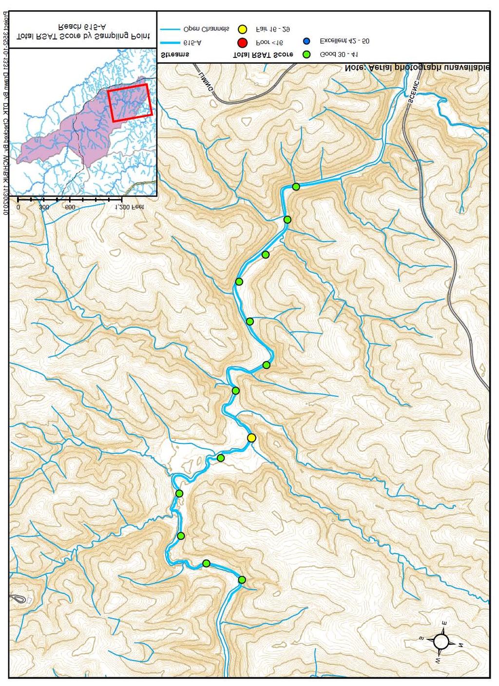
2 Basin 615, South Fork of Quantico Creek - Project Reach Descriptions Reach Name: 615-A Coordinates (NAD 83, Virginia State Plane North): , to , Average RSAT Score: 36 General Description: Reach 615-A begins at a marked transition in channel morphology, from the steeply-sloped, bedrock and boulder dominated reaches located immediately upstream, to a gently meandering channel composed of predominantly gravel and cobble substrate. An average score of 6 points (based on thirteen sample locations) for channel stability, scouring/deposition, and physical in-stream habitat indicate a good quality stream that is geomorphically stable. Approximately 80% of streambanks are stable, with only minor bank scouring, occurring opposite of gravel point bars. Approximately 25-49% of bed material is embedded gravel and cobble, with well-formed pools and riffles, and depositional point bars comprised of coarse gravel with minimal sand deposits. Riparian habitat is in excellent condition along this reach, with a wide forested buffer in excess of 200ft on either side of the channel. Canopy cover is dense, providing greater than 80% shading over the stream. In addition, the biological indicator scores are excellent, corresponding to the rich diversity and large quantities of macroinvertebrates, including mayflies, stoneflies, and caddisflies. Water quality along Reach 615-A is good, with an average score of 5, indicative of light substrate fouling, low TDS, and visibility to depths greater than 1.5ft, despite large amounts of leaf litter and organic debris from the surrounding riparian forest. Problem Areas: None Recommendations: None A-1
3 A-2
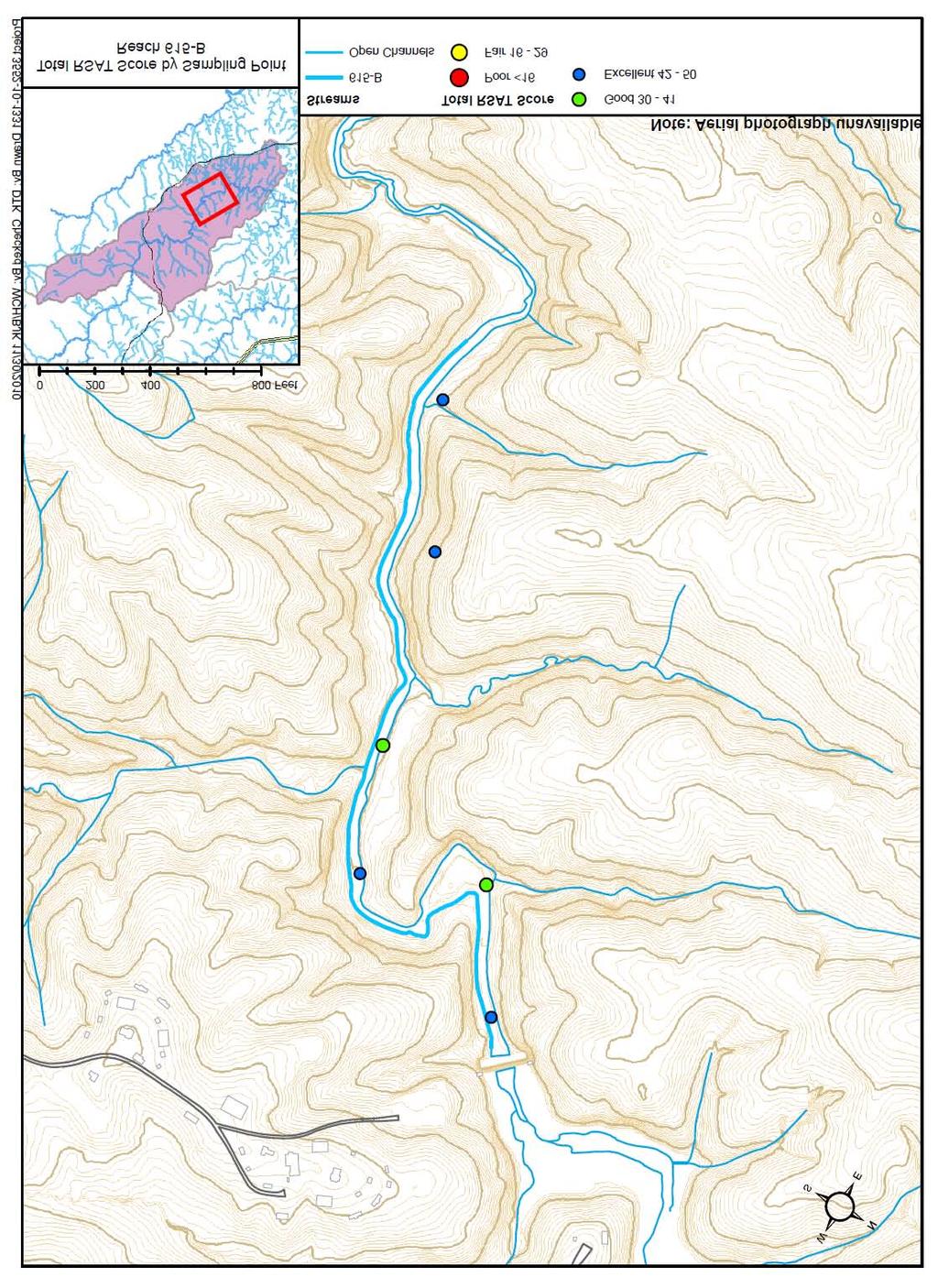
4 Reach Name: 615-B Coordinates (NAD 83, Virginia State Plane North): , to , Average RSAT Score: 43 General Description: Reach 615-B received the highest RSAT scoring of all the reaches included in the Quantico Creek Watershed Assessment, with an average total score of 43. Reach 615-B is characterized by stable, well-vegetated streambanks, a lack of bank sloughing or erosion, and highly resistant bed and bank materials, giving the reach an excellent channel stability rating. In addition, the boulder and cobble dominated stream provides a varied depth and velocity regime, few depositional features, low embeddness of riffle material, and deep pools (providing refugia for fish and other aquatic organisms); all features that are representative of excellent scouring/deposition and physical instream habitat scores. Riparian habitat remains in excellent condition, with a wide forested buffer in excess of 200ft on either side of the channel. Canopy cover is dense, providing greater than 80% shading over the stream. In addition, the biological indicator scores are excellent, corresponding to the rich diversity and large quantities of macroinvertebrates. Water quality along Reach 615-A is good, with an average score of 5, indicative of light substrate fouling, low TDS, and visibility to depths greater than 1.5ft, despite large amounts of leaf litter and organic debris from the surrounding riparian forest. Problem Areas: None Recommendations: None A-3
5 A-4

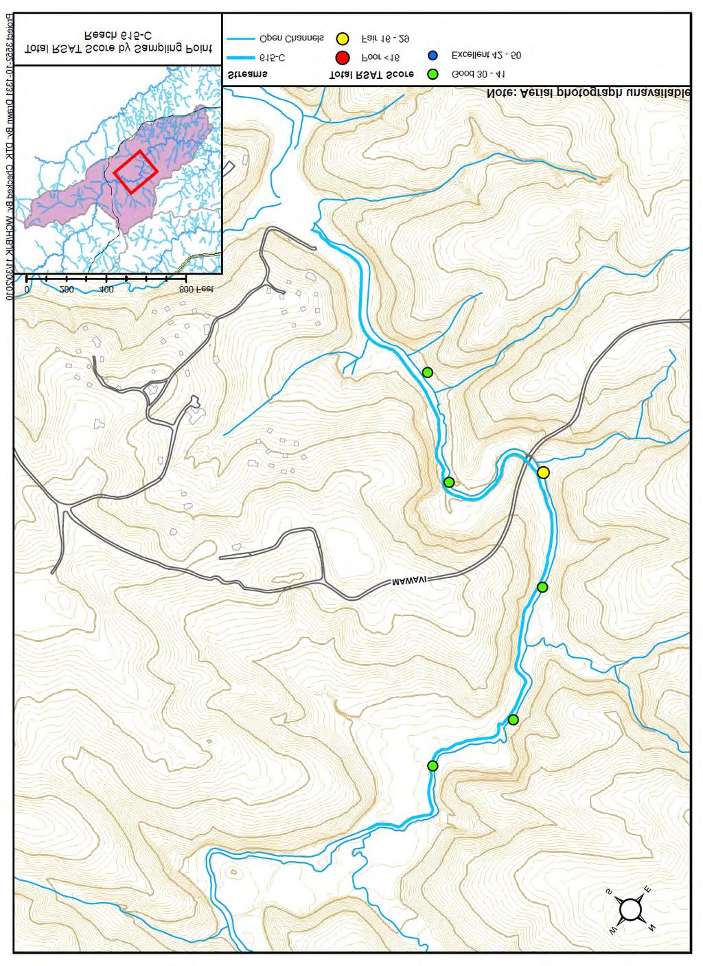
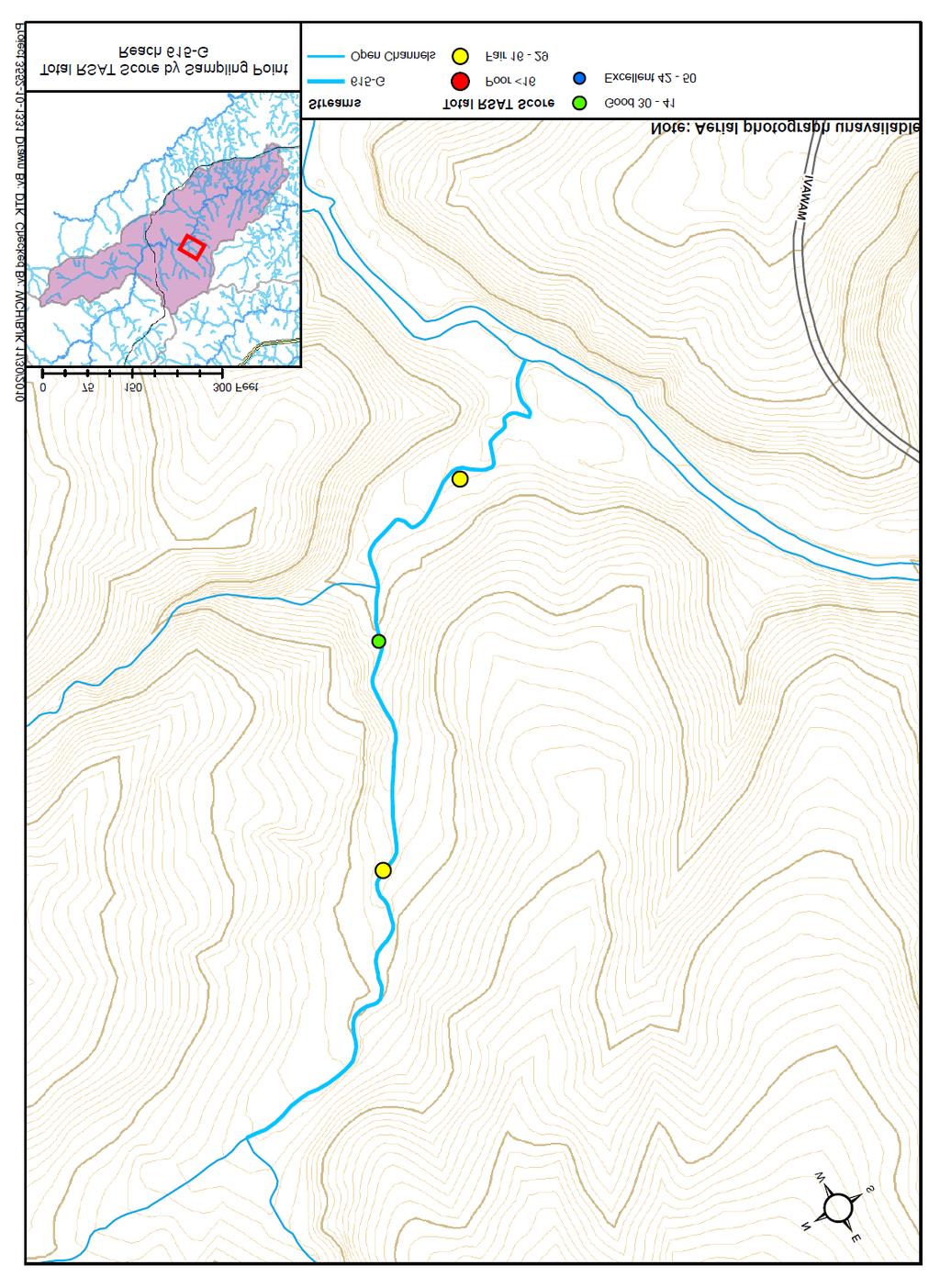
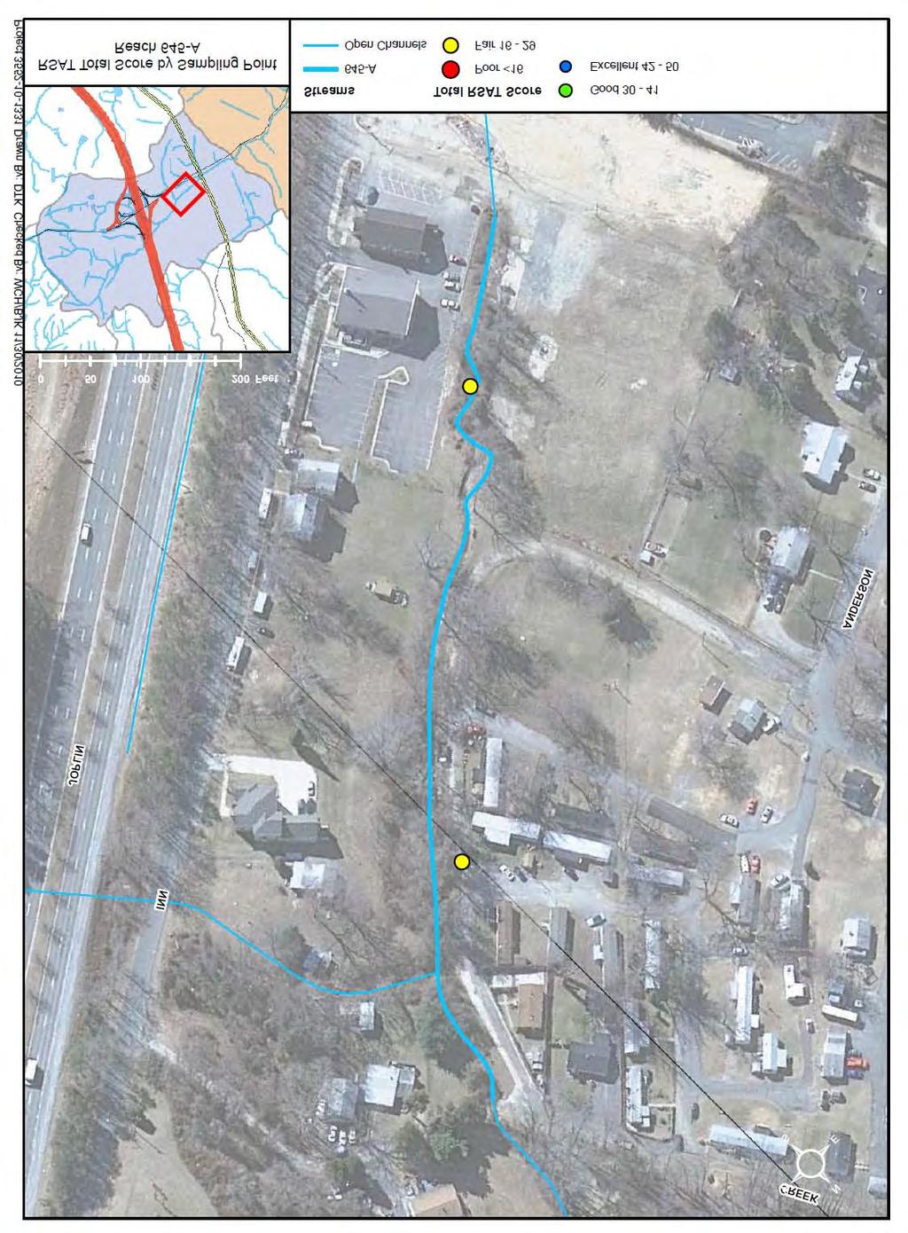
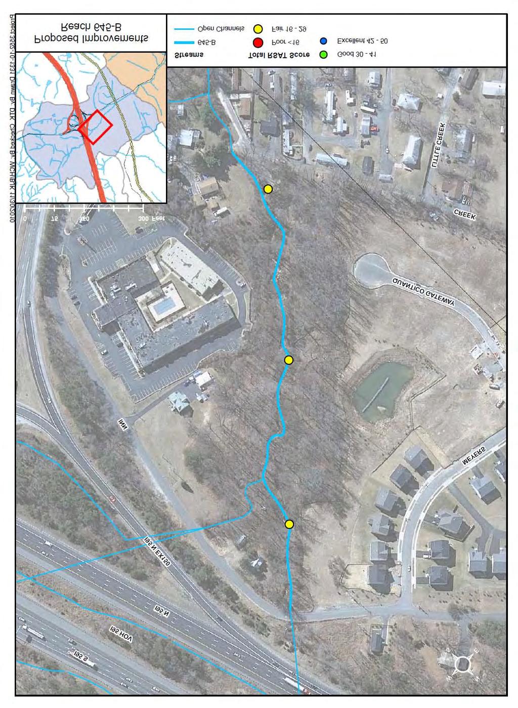
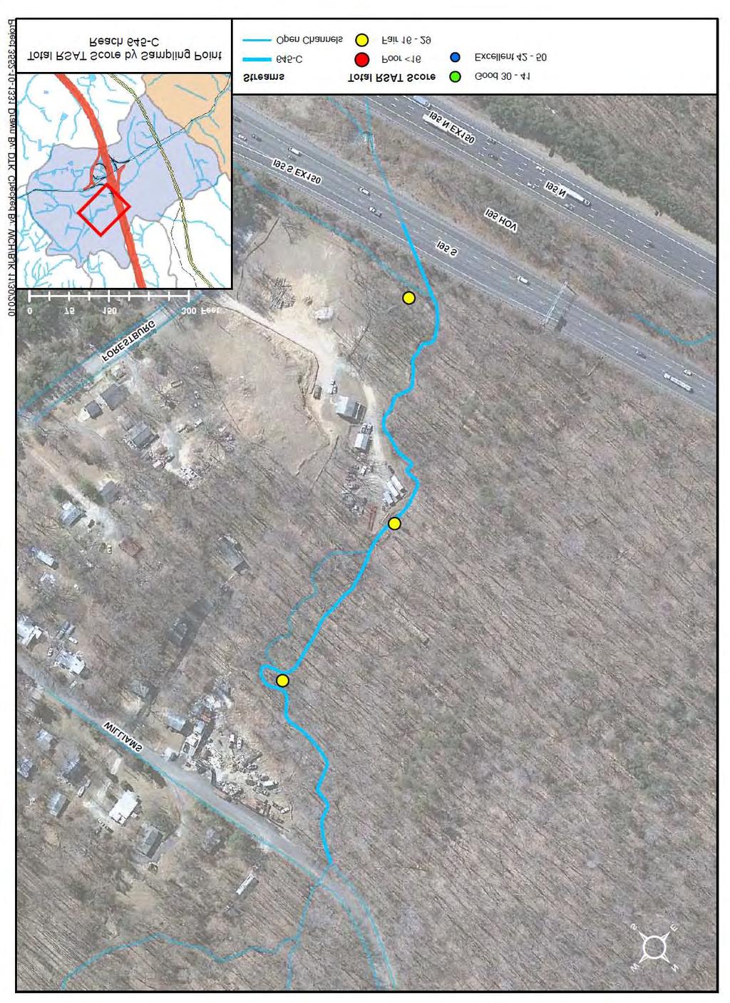
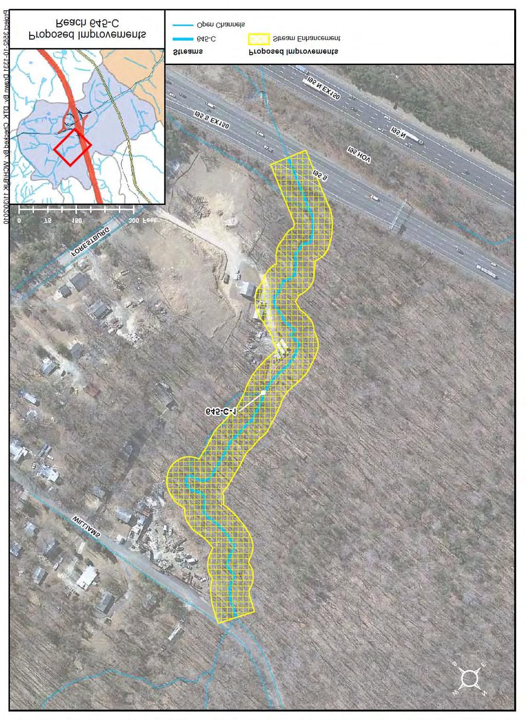
6 Reach Name: 615-C Coordinates (NAD 83, Virginia State Plane North): , to , Average RSAT Score: 33 General Description: Reach 615-C received an average total RSAT score of 33, indicating a good quality stream that is geomorphically stable. Overall, Reach 615-C has excellent channel stability, with approximately 80% of the streambanks stable, a general lack of bank sloughing or erosion, and highly resistant bed and bank materials. Channel scouring/ deposition scores were good, with only 25-49% of the gravel and cobble bed material embedded, well-formed pools and riffles, and depositional point bars comprised of coarse gravel with minimal sand deposits. Physical instream habitat was also good, with a varied velocity and depth regime, and a mix of riffles, runs, and pools. Riparian habitat remains in excellent condition, with a wide forested buffer in excess of 200ft on either side of the channel. Canopy cover is dense, providing greater than 80% shading over the stream. However, biological indicator and water quality ranked fair, corresponding to a reduced diversity and quantity of macroinvertebrates, coupled with an increase in substrate fouling, TDS, and reduced depth of visibility. Problem Areas: None Recommendations: None A-5
7 A-6
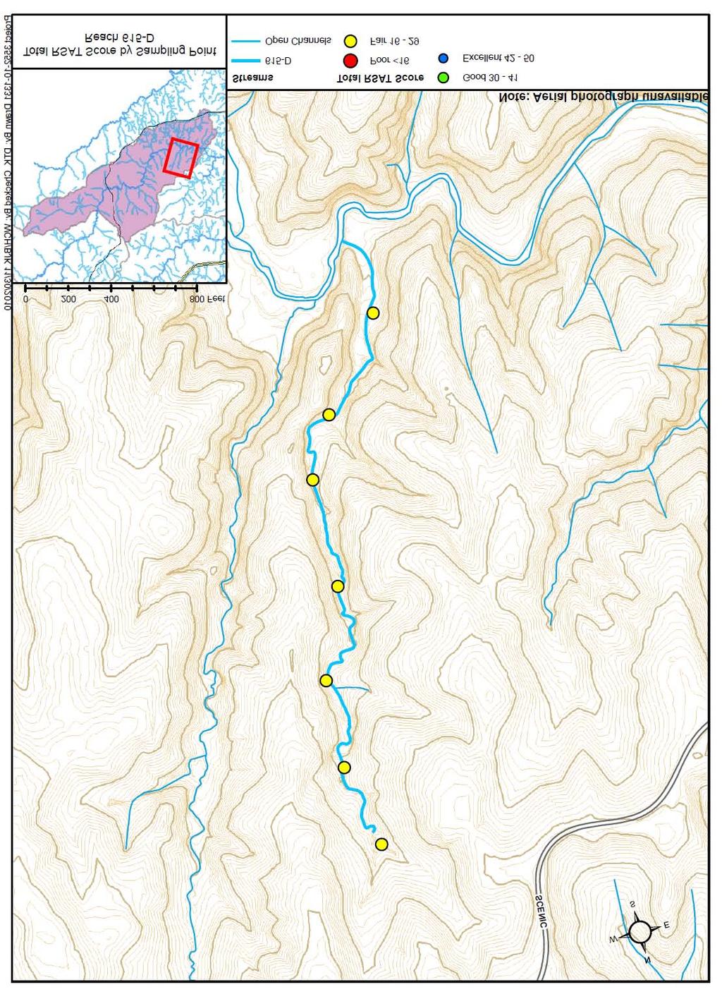
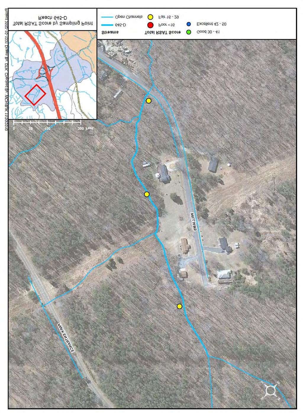
8 Reach Name: 615-D Coordinates (NAD 83, Virginia State Plane North): , to , Average RSAT Score: 23 General Description: Reach 615-D is a fair quality stream, with an average total RSAT score of 23. In general, Reach 615-D has good channel stability, with 71-80% of the streambanks stable, relatively little bank sloughing or erosion, and resistant bed and bank materials. Channel scouring/deposition and physical instream habitat scores were fair, with increased embeddness of riffle material, few deep pools and a shallow riffle and run dominated morphology. Riparian habitat is in excellent condition, with a wide forested buffer in excess of 200ft on either side of the channel, and canopy cover is dense, providing greater than 80% shading. Biological indicators are absent along this reach (resulting in a score of 0), as the flow is shallow and intermittent. Water quality is fair, with a moderate level of substrate fouling (21-50%), increased TDS, and reduced depth of visibility. Problem Areas: None Recommendations: None A-7
9 A-8
10 Reach Name: 615-E Coordinates (NAD 83, Virginia State Plane North): , to , Average RSAT Score: 28 General Description: Reach 615-E is a fair quality stream, with an average total RSAT score of 28. Reach 615-E has good channel stability, with 71-80% of the streambanks stable, relatively little bank sloughing or erosion, and resistant bed and bank materials. Channel scouring/deposition and physical instream habitat scores were fair, with increased embeddness of riffle material, few deep pools and a shallow riffle and run dominated morphology. Riparian habitat is in excellent condition, with a wide forested buffer in excess of 200ft on either side of the channel, and canopy cover is dense, providing greater than 80% shading. Biological indicators are poor, with a nearly depauperate population of midgeflies and snails. Water quality is fair, with a moderate level of substrate fouling, increased TDS, and reduced depth of visibility. Problem Areas: None Recommendations: None A-9
11 A-10
12 Reach Name: 615-F Coordinates (NAD 83, Virginia State Plane North): , to , Average RSAT Score: 30 General Description: Reach 615-F is a good quality stream, with an average total RSAT score of 30. Reach 615-F has good channel stability and scouring/deposition scores, due to stable streambanks, very little bank sloughing or erosion, and resistant bed and bank materials. Physical instream habitat scores were fair, with increased embeddness of riffle material, few deep pools and a shallow riffle and run dominated morphology. Riparian habitat is in excellent condition, with a wide forested buffer in excess of 200ft on either side of the channel, and canopy cover is dense, providing greater than 80% shading. Biological indicators are fair, with a few pollution-tolerant species, such as caddisfly and midgefly. Water quality is fair, with a moderate level of substrate fouling, increased TDS, and reduced depth of visibility. Problem Areas: None Recommendations: None A-11
13 A-12
14 Reach Name: 615-G Coordinates (NAD 83, Virginia State Plane North): , to , Average RSAT Score: 28 General Description: Reach 615-G is a fair quality stream, with an average total RSAT score of 28. Reach 615-G has good channel stability, with stable streambanks, little bank sloughing or erosion, and resistant bed and bank materials. Channel scouring/deposition and physical instream habitat scores were fair, with increased embeddness of riffle material, few deep pools and a shallow riffle and run dominated morphology. Riparian habitat is in excellent condition, with a wide forested buffer in excess of 200ft on either side of the channel, and canopy cover is dense, providing greater than 80% shading. Biological indicators are fair, with a few pollution-tolerant species, such as caddisfly and midgefly. Water quality is fair, with a moderate level of substrate fouling, increased TDS, and reduced depth of visibility. Problem Areas: None Recommendations: None A-13
15 A-14
16 Reach Name: 615-H Coordinates (NAD 83, Virginia State Plane North): , to , Average RSAT Score: 25 General Description: Reach 615-H is a fair quality stream, with an average total RSAT score of 25. Reach 615-H has good channel stability, with 71-80% of the streambanks stable, relatively little bank sloughing or erosion, and resistant bed and bank materials. Channel scouring/deposition and physical instream habitat scores were fair, with increased embeddness of riffle material, few deep pools and a shallow riffle and run dominated morphology. Riparian habitat is in excellent condition, with a wide forested buffer in excess of 200ft on either side of the channel, and canopy cover is dense, providing greater than 80% shading. Biological indicators are poor, with a depauperate population of midgeflies. Water quality is fair, with a moderate level of substrate fouling, increased TDS, and reduced depth of visibility. Problem Areas: None Recommendations: None A-15
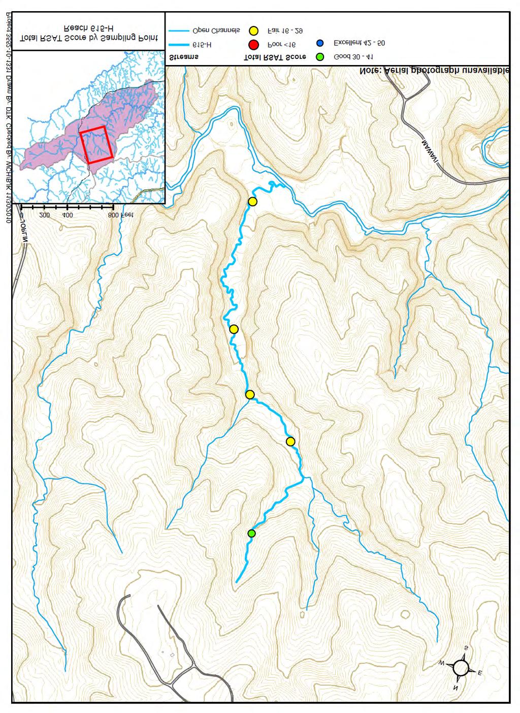
17 A-16
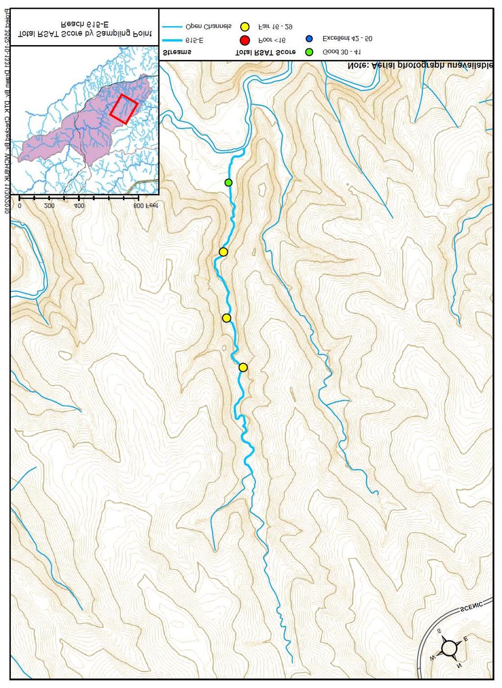
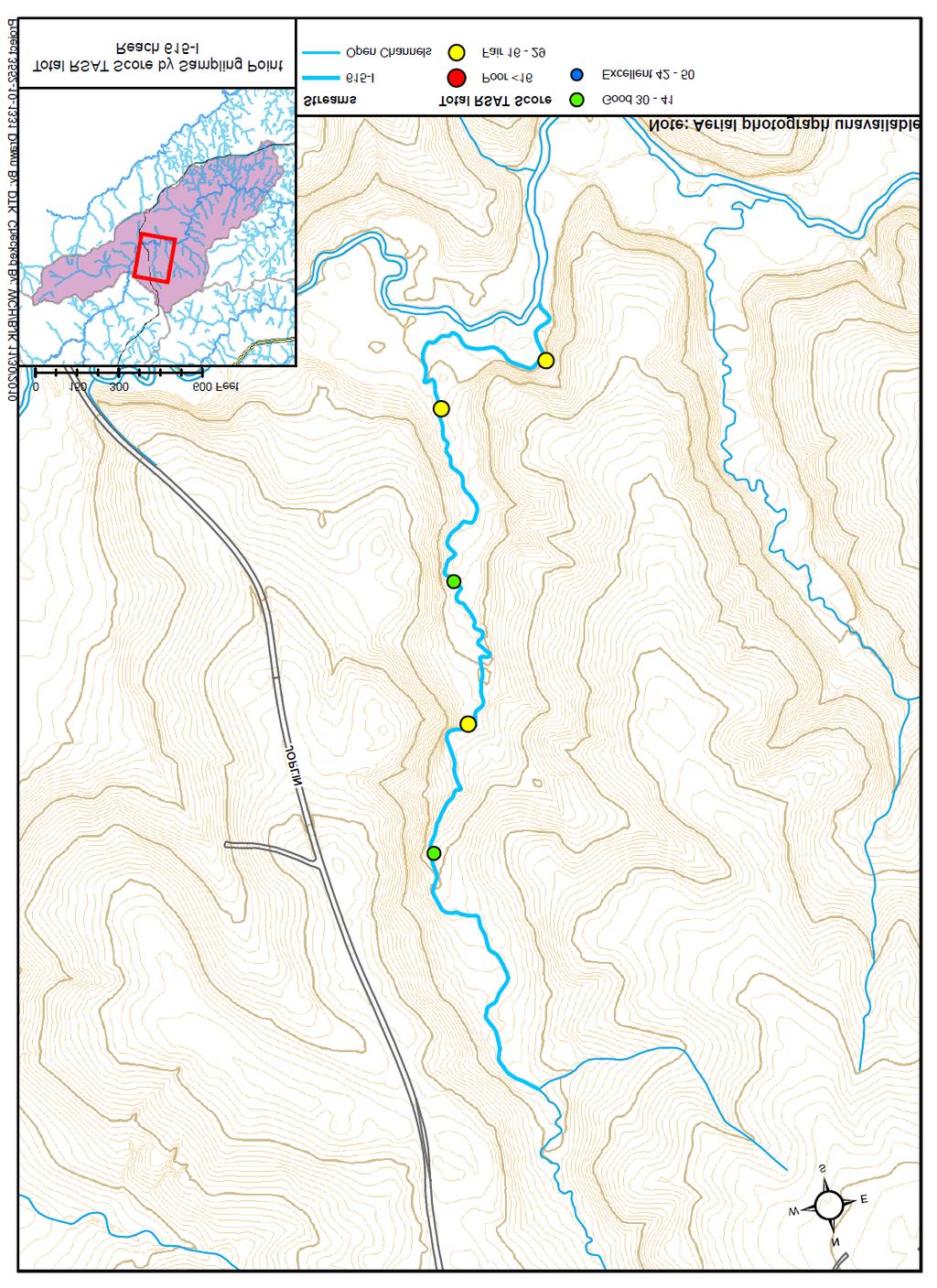
18 Reach Name: 615-I Coordinates (NAD 83, Virginia State Plane North): , to , Average RSAT Score: 28 General Description: Reach 615-I is a fair quality stream, with an average total RSAT score of 28. Reach 615-I has good channel stability, with stable streambanks, little bank sloughing or erosion, and resistant bed and bank materials. Channel scouring/deposition and physical instream habitat scores were fair, with increased embeddness of riffle material, few deep pools and a shallow riffle and run dominated morphology. Riparian habitat is in excellent condition, with a wide forested buffer in excess of 200ft on either side of the channel, and canopy cover is dense, providing greater than 80% shading. Biological indicators are fair, with a few pollution-tolerant species, such as caddisfly and midgefly. Water quality is fair, with a moderate level of substrate fouling, increased TDS, and reduced depth of visibility. Problem Areas: None Recommendations: None A-17
19 A-18

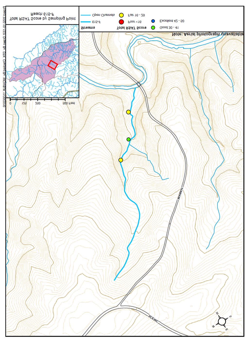
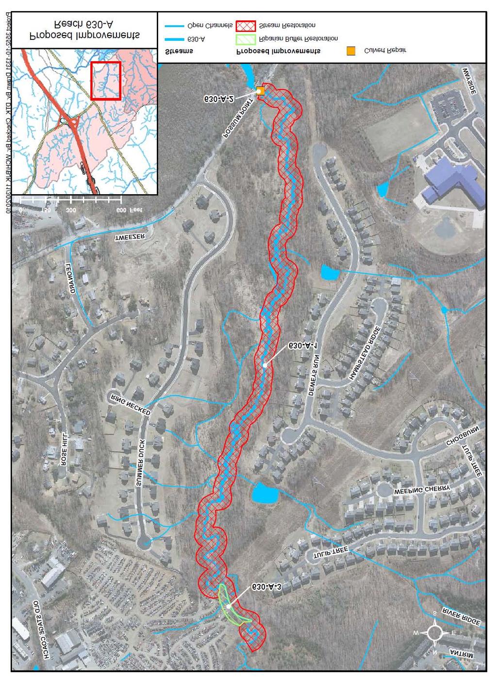
20 Basin 630, Dewey s Creek - Project Reach Descriptions Reach Name: 630-A Coordinates (NAD 83, Virginia State Plane North): , to , Average RSAT Score: 15 General Description: Reach 630-A is an example of a Reach 630-A poor quality stream, with an 100% average total RSAT score of only 80% 15. The low score is due mainly to 60% widespread, systemic channel erosion, coupled with large 40% Excellent Good amounts of sand and sediment 20% Fair deposition, and no available 0% Poor biological indicators. Channel stability along Reach 630-A had an average score of 2, with more than 50% of the streambanks experiencing sloughing or scour, undercut streambanks, and frequent tree falls, with streambanks consisting of highly erodible, sandy soils. Bank erosion is particularly severe on the outside of bends, in areas where riparian vegetation is sparse, and alongside freshly deposited sand bars. Channel scouring/deposition and physical instream habitat scores were fair, with an increasing number of depositional features, nearly 75% embeddness of riffle material, few pools (most appeared to have been filled in with sediment). Riparian habitat is in fair condition, with a predominantly wooded corridor, but with large gaps in woody vegetation and canopy coverage. Biological indicators are absent along this reach (resulting in a score of 0). Water quality is fair, with a moderate level of substrate fouling, increased TDS, and a depth of visibility no more than 1ft. Problem Areas: Channel incision and widening along the lower portion of the basin, from Tulip Tree Place to Possum Point Road, has resulted in widespread, systemic bank erosion. o Removal of the riparian forest, encroachment on the stream corridor, and dumping of debris has left streambanks susceptible to overbank runoff, gully erosion and localized bank erosion, behind Skip s Auto Parts at the intersection of Jefferson Davis Highway and Old Stage Coach Road. A-19
21 o Sediment and debris (resulting from channel erosion upstream) has been deposited at the Possum Point Road culvert, severely restricting flow, reducing flood capacity, and posing a risk to public safety and infrastructure. Recommendations: Restore more than 4300ft of stream, from Tulip Tree Place to Possum Point Road, using fabric and plant bank treatment with live fascines or brush mattress to provide immediate vegetative cover, and up to 14 rock riffles for permanent grade stabilization. o Remove debris and rubble from the streambanks behind Skip s Auto Parts (at the intersection of Jefferson Davis Highway and Old Stage Coach Road) and restore the riparian buffer zone with seed, straw and container plants (at a planting density of up to 1200 stems/acre) along 250 linear feet of channel. Establish a conservation easement, or permanent deed restriction area, to protect the buffer zone to a minimum of 100ft from the channel. o Repair or retrofit the culvert at Possum Point Road with up to 4 rock weirs or wing deflectors and a floating trash rack to focus the flow, enhance sediment transport, trap woody debris, and prevent siltation of the culverts. A-20
22 A-21
23 A-22


24 Reach Name: 630-B Coordinates (NAD 83, Virginia State Plane North): , to , Average RSAT Score: 22 General Description: Reach 630-B is a fair quality Reach 630-B stream, with an average total 100% RSAT score of 22. Channel 80% widening is responsible for low 60% channel stability scores (with an average value of 4) and widespread 40% Excellent Good bank erosion along approximately 20% Fair 50% of the reach. Channel 0% Poor scouring/deposition scores were fair, with increased deposition of sand and sediment and increased embeddness of riffle material. Physical instream habitat was in good condition, despite systemic erosion and subsequent deposition downstream. A good mix of riffles, runs and pools is present, along with a heterogeneous mix of bed materials, consisting of cobbles, gravel, sand and sediment. Riparian habitat is in good condition, with a forested buffer of at least 100ft on either side of the channel, and dense canopy cover, providing approximately 60-79% shading. Biological indicators are poor, with a small population of the most pollution-tolerant macroinvertebrates. Water quality is fair, with a moderate level of substrate fouling, increased TDS, and reduced depth of visibility. Problem Areas: Channel incision and widening has resulted in systemic streambank erosion, downstream from Jefferson Davis Highway to the upstream end of Reach 630-A. o A large woody debris jam, approximately 100 feet downstream from Jefferson Davis Highway, has resulted in localized bank erosion, which threatens to undermine an existing utility pole on the left descending (north) bank. o Channel incision along an unnamed tributary, south of Wayside Drive and west of Mountain Laurel Loop, has undermined an existing concrete pipe outfall and headwall along the left descending bank, creating a vertical drop of more than 8 feet. A-23
25 Recommendations: Restore more than 2300ft of stream, from Jefferson Davis Highway to Tulip Tree Place, using fabric and plant bank treatment with rock toe to stabilize eroding streambanks, and up to 6 rock riffles for permanent grade stabilization. o Relocate an undermined utility pole along the left descending (north) bank, remove a large woody debris jam, and restore approximately 100 feet of eroded streambank downstream from Jefferson Davis Highway. o Stabilize 200ft of tributary, south of Wayside Drive and west of Mountain Laurel Loop, using fabric and plant bank treatment with rock toe, and replace the undermined pipe outfall and headwall. A-24
26 A-25
27 A-26


28 Reach Name: 630-C Coordinates (NAD 83, Virginia State Plane North): , to , Average RSAT Score: 26 General Description: Reach 630-C is a fair quality Reach 630-C stream, with an average total 100% RSAT score of 26. Reach 630-C 80% has good channel stability, with relatively stable streambanks, little 60% bank sloughing or erosion, and 40% Excellent resistant bed and bank materials. Good 20% Fair Channel scouring/deposition scores 0% Poor were fair, with increased deposition of sand and sediment and increased embeddness of riffle material. Physical instream habitat was in good condition, with a mix of riffles, runs and deep pools present, along with a heterogeneous mix of bed materials, consisting of cobbles, gravel, sand and sediment. Riparian habitat is in good condition, with a forested buffer of at least 100ft on either side of the channel, and dense canopy cover, providing approximately 60-79% shading. Biological indicators are poor, with only a small population of pollution-tolerant macroinvertebrates. Water quality is good, with a low level of substrate fouling, moderate TDS, and visibility to a depth of nearly 3ft. Problem Areas: Localized bank erosion and subsequent deposition of coarse gravel and sediments threaten adjacent properties between Interstate I-95 and Jefferson Davis Highway. o Streambank erosion is particularly severe in the vicinity of the apartment/condominium complex at Briarwood and Interstate Drives. o Removal of riparian vegetation and loss of associated root mass has left the streambank vulnerable to continued erosion and mass wasting, along a temporary access road on the right descending bank, downstream of Interstate Drive to Dry Powder Circle. Recommendations: Enhance nearly 3800ft of degraded stream, from Interstate 1-95 to Jefferson Davis Highway, using fabric and plant bank treatment and up to 12 rock weirs or wing deflectors to reduce bank scouring. A-27
29 o Restore the riparian buffer zone with seed, straw and container plants (at a planting density of up to 1200 stems/acre) along 1000 linear feet of channel, downstream of Interstate Drive to Dry Powder Circle. Establish a conservation easement, or permanent deed restriction area, to protect the buffer zone to a minimum of 100ft from the channel. A-28
30 A-29
31 A-30

32 Reach Name: 630-D Coordinates (NAD 83, Virginia State Plane North): , to , Average RSAT Score: 21 General Description: Reach 630-D is a fair quality stream, with an average total RSAT score of 21. Channel incision and widening is responsible for low channel stability scores and bed and bank erosion along nearly 50% of the reach. Channel scouring/deposition and physical instream habitat scores were fair, with an increase in deposition, increased embeddness of riffle material, and a low number of deep pools. 100% 80% 60% 40% 20% 0% Reach 630-D Excellent Good Fair Poor Riparian habitat is in good condition, with a forested buffer of at least 100ft on either side of the channel, and dense canopy cover, providing approximately 60-79% shading. Biological indicators are fair, with a few pollution-tolerant species, such as caddisfly and midgefly. Water quality is fair, with a moderate level of substrate fouling, increased TDS, and reduced depth of visibility. Problem Areas: Channel incision and widening has resulted in systemic streambank erosion, and exposure of a previously buried sewer line parallel to the stream, south of Four Seasons Drive to the culvert at Interstate I-95. o Illegal dumping of concrete rubble, tires and other debris (via an access road from Old Stage Road) has created and impoundment in the channel, interfering with the flow of water and sediment. Recommendations: Realign and restore more than 2800ft of stream channel, along the sewer line south of Four Seasons Drive to the culvert at Interstate I-95, using fabric and plant bank treatment with rock toe to stabilize eroding streambanks, and up to 7 rock riffles for permanent grade stabilization. o Remove dumped rubble, tires and other debris, creating an impoundment near the access road from Old Stage Road, prior to restoration. A-31
33 A-32
34 A-33


35 Reach Name: 630-E Coordinates (NAD 83, Virginia State Plane North): , to , Average RSAT Score: 34 General Description: Reach 630-E is a good quality stream, with an average total RSAT score of 36. Reach 630-E has excellent channel stability and scouring/deposition scores, due to stable streambanks, few signs of bank sloughing or erosion, and resistant bed and bank materials. Physical instream habitat scores are good, with a mix of riffle, run and pool habitat, and a varied velocity and depth regime. 100% 80% 60% 40% 20% 0% Reach 630-E Excellent Good Fair Poor Riparian habitat is in excellent condition, with a wide forested buffer in excess of 200ft on either side of the channel, and canopy cover is dense, providing greater than 80% shading. However, biological indicators are poor, with a limited population of pollution-tolerant midgeflies and snails. Water quality is fair, with a moderate level of substrate fouling, increased TDS, and reduced depth of visibility. Problem Areas: None Recommendations: None A-34
36 A-35

37 Reach Name: 630-F Coordinates (NAD 83, Virginia State Plane North): , to , Average RSAT Score: 24 General Description: Reach 630-F is a fair quality stream, with an average total RSAT score of 24. Channel incision is responsible for low channel stability scores and bed and bank erosion along nearly 50% of the reach. Channel scouring/deposition and physical instream habitat scores were fair, with an increase in deposition, increased embeddness of riffle material, and few deep pools. 100% 80% 60% 40% 20% 0% Reach 630-F Excellent Good Fair Poor Riparian habitat is in good condition, with a forested buffer of at least 100ft on either side of the channel, and dense canopy cover, providing more than 60% shading. Biological indicators are poor, with only a few midgeflies found throughout the reach. Water quality is fair, with a moderate level of substrate fouling, increased TDS, and reduced depth of visibility. Problem Areas: Moderate channel incision has been slowed by woody debris jams (that act as natural de facto grade control) and bank stabilization provided by a wide riparian forest buffer, from the upstream end of the reach at Telescope Lane, to the confluence with Reach 630-C near Dry Powder Circle. Recommendations: Purchase, preserve and monitor the existing riparian corridor with a permanent deed restriction or conservation easement, along more than 5300ft of stream, from the upstream end of the reach at Telescope Lane, to the confluence with Reach 630-C near Dry Powder Circle. A-36
38 A-37
39 A-38

40 Basin 645, Upper Little Creek - Project Reach Descriptions Reach Name: 645-A Coordinates (NAD 83, Virginia State Plane North): , to , Average RSAT Score: 18 General Description: Reach 645-A is a fair quality Reach 645-A stream, with an average total score 100% of 18. Channel stability scores 80% along this reach are influenced significantly by localized bank 60% erosion, with approximately 50-40% Excellent 70% of the streambanks Good 20% Fair experiencing sloughing or scour. 0% Poor Bank erosion is particularly severe near Creek Road, where residential development has encroached on the stream corridor and riparian vegetation has been removed. Channel scouring/deposition and physical instream habitat scores were fair, with an increasing number of depositional features, increased embeddness of riffle material, and few deep pools. Riparian habitat is in poor condition, with only a narrow band of trees and very little woody vegetation near Creek Road and adjacent to the parking lot at First Assembly of God Church. Biological indicators are poor, with only a few midgeflies found throughout the reach. Water quality is fair, with a moderate level of substrate fouling, increased TDS, and a depth of visibility no more than 1ft. Problem Areas: Removal of riparian forest and encroachment on the stream corridor has prompted localized bank erosion and mass wasting from Creek Road to the parking lot at First Assembly of God Church. Recommendations: Enhance approximately 950ft of degraded stream, from Creek Road to the parking lot at First Assembly of God Church, using fabric and plant bank treatment and up to 3 rock weirs or wing deflectors to reduce bank scouring. A-39
41 A-40
42 A-41

43 Reach Name: 645-B Coordinates (NAD 83, Virginia State Plane North): , to , Average RSAT Score: 22 General Description: Reach 645-B is a fair quality Reach 645-B stream, with an average total score 100% of 22. Channel stability scores 80% along this reach are influenced 60% significantly by localized bank erosion and channel widening, with 40% Excellent Good approximately 50% of the 20% Fair streambanks experiencing 0% Poor sloughing or scour. Bank erosion is particularly severe along the lower portion of this reach, approaching Creek Road, where residential development has encroached on the stream corridor and riparian vegetation has been removed. Channel scouring/deposition and scores were fair, with an increasing number of depositional features and increased embeddness of riffle material. Physical instream habitat scores are good, with a mix of riffle, run and pool habitat, and a varied velocity and depth regime. Riparian habitat is in fair condition, with a predominantly wooded corridor, but with large gaps in woody vegetation and canopy coverage. Biological indicators are poor, with only a few midgeflies found throughout the reach. Water quality is fair, with a moderate level of substrate fouling, increased TDS, and a depth of visibility to approximately 1.5ft. Problem Areas: Removal of riparian forest and encroachment on the stream corridor continues upstream of Creek Road, to the culvert at Interstate I-95, accelerating localized streambank erosion. Recommendations: Enhance nearly 1300ft of degraded stream, upstream from Creek Road to the culvert at Interstate I-95, using fabric and plant bank treatment and up to 4 rock weirs or wing deflectors. A-42
44 A-43
45 A-44
46 Reach Name: 645-C Coordinates (NAD 83, Virginia State Plane North): , to , Average RSAT Score: 19 General Description: Reach 645-C is a fair quality stream, with an average total score of 19. Reach 645-C has fair channel stability, with approximately 50% stable streambanks, and scour concentrated on the outside bends of the stream. Channel scouring/deposition and physical instream habitat scores were fair, with an increasing number of depositional features, increased embeddness of riffle material, and few deep pools. 100% 80% 60% 40% 20% 0% Reach 645-C Excellent Good Fair Poor Riparian habitat is in fair condition, with large gaps in woody vegetation and canopy coverage. Biological indicators are poor, with only a handful of pollution tolerant species found throughout the reach. Water quality is fair, with a moderate level of substrate fouling, increased TDS, and a depth of visibility to approximately 1.5ft. Problem Areas: Removal of riparian forest, followed by mowing to the top of the streambank, has left the channel susceptible to localized bank erosion and prompted mass wasting, upstream from Interstate I-95 to Williams Road. Recommendations: Enhance approximately 1500ft of degraded stream, upstream from Interstate I-95 to Williams Road, using fabric and plant bank treatment and up to 5 rock weirs or wing deflectors. A-45
47 A-46
48 A-47

49 Reach Name: 645-D Coordinates (NAD 83, Virginia State Plane North): , to , Average RSAT Score: 24 General Description: Reach 645-D is a fair quality stream, with an average total RSAT score of 24. Reach 645-D has good channel stability, with relatively stable streambanks, little bank sloughing or erosion, and resistant bed and bank materials. Channel scouring/deposition and physical instream habitat scores were fair, with an increasing number of depositional features, increased embeddness of riffle material, and few deep pools. 100% 80% 60% 40% 20% 0% Reach 645-D Excellent Good Fair Poor Riparian habitat is in fair condition, with large gaps in woody vegetation and canopy coverage. Biological indicators are poor, with only a handful of pollution tolerant species found throughout the reach. Water quality is fair, with a moderate level of substrate fouling, increased TDS, and a depth of visibility to approximately 1ft. Problem Areas: Moderate channel incision has been slowed by woody debris jams and bank stabilization provided by the existing riparian forest, from Park Entrance Road to Williams Road. Recommendations: Purchase, preserve and monitor the existing riparian corridor with a permanent deed restriction or conservation easement, along nearly 1300ft of stream, from Park Entrance Road to Williams Road. A-48
50 A-49
Why Geomorphology for Fish Passage
 Channel Morphology - Stream Crossing Interactions An Overview Michael Love Michael Love & Associates mlove@h2odesigns.com (707) 476-8938 Why Geomorphology for Fish Passage 1. Understand the Scale of the
C. STUDENT FIELD DATA SHEETS
 C. STUDENT FIELD DATA SHEETS Student Name Date Time Stream Location Parameter to find Your Group s Results Units trial trial average Transparency cm Water Temperature Air Temperature Weather N sunny N
Assessment. Assessment
 2001 SPRINGBROOK CREEK RESTORATION - THREE YEAR POST-CONSTRUCTION REVIEW - Presented by Bruce Henderson and Andy Harris 2005 River Restoration Northwest Symposium Skamania Lodge, Washington www.hendersonlandservices.com
DETAILED DESCRIPTION OF STREAM CONDITIONS AND HABITAT TYPES IN REACH 4, REACH 5 AND REACH 6.
 DETAILED DESCRIPTION OF STREAM CONDITIONS AND HABITAT TYPES IN REACH 4, REACH 5 AND REACH 6. The Eklutna River was divided into study reaches (figure 1) prior to this site visit. Prominent geologic or
Flood and Stream Restoration
 2 3 4 Pedestrian bridge under construction 3 CSPs perched on DS side Large area of sand deposition Bottom layer of gabions has been scoured out large bar of gabion stone Gabions slumping bank slope failure
Fluvial Driven Alluvial Fans
 Fluvial Driven Alluvial Fans Restoration Project Evaluations - Examples from the Russian and Napa River Watersheds Mia Docto Masters Thesis UC Berkeley 1. Basic Fan Description 2. Fluvial Driven Fan Characteristics
Carmel River Bank Stabilization at Rancho San Carlos Road Project Description and Work Plan March 2018
 Carmel River Bank Stabilization at Rancho San Carlos Road Project Description and Work Plan March 2018 EXISTING CONDITION The proposed Carmel River Bank Stabilization at Rancho San Carlos Road Project
GENERAL SUMMARY BIG WOOD RIVER GEOMORPHIC ASSESSMENT BLAINE COUNTY, IDAHO
 GENERAL SUMMARY BIG WOOD RIVER GEOMORPHIC ASSESSMENT BLAINE COUNTY, IDAHO Prepared For Trout Unlimited 300 North Main Street, Hailey, Idaho, 83333 Prepared By P. O. Box 8578, 140 E. Broadway, Suite 23,
HAW CREEK, PIKE COUNTY, MISSOURI-TRIB TO SALT RIVER ERODING STREAM THREATHENING COUNTY ROAD #107, FOURTEEN FT TALL ERODING BANK WITHIN 4 FT OF THE
 HAW CREEK, PIKE COUNTY, MISSOURI-TRIB TO SALT RIVER ERODING STREAM THREATHENING COUNTY ROAD #107, FOURTEEN FT TALL ERODING BANK WITHIN 4 FT OF THE ROAD, PROJECT CONSTRUCTED IN 1 DAY, MARCH 10, 2009 BY
Riparian Assessment. Steps in the right direction... Drainage Basin/Watershed: Start by Thinking Big. Riparian Assessment vs.
 Riparian Assessment vs. Monitoring Riparian Assessment What is a healthy stream? Determine stream/riparian health Determine change or trend, especially in response to mgmt Classification = designation
CASE STUDIES. Introduction
 Introduction The City of Winston-Salem faces the challenge of maintaining public infrastructure (e.g., water and sewer lines, storm drains, roads, culverts and bridges) while minimizing the potential impacts
Stream Geomorphology. Leslie A. Morrissey UVM July 25, 2012
 Stream Geomorphology Leslie A. Morrissey UVM July 25, 2012 What Functions do Healthy Streams Provide? Flood mitigation Water supply Water quality Sediment storage and transport Habitat Recreation Transportation
Upper Mississippi River Basin Environmental Management Program Workshop
 Presentation to the Upper Mississippi River Basin Environmental Management Program Workshop by Michael Rodgers River Engineer US Army Corps of Engineers, St. Louis District August 17, 2007 Engineering
Habitat Assessment. Peggy Compton UW-Extension Water Action Volunteers Program Coordinator
 Habitat Assessment Peggy Compton UW-Extension Water Action Volunteers Program Coordinator Adapted from a presentation by Jean Unmuth, Water Quality Biologist, WI DNR dnr.wi.gov www.uwex.edu erc.cals.wisc.edu
Fish Passage at Road Crossings
 Fish Passage at Road Crossings 1 Crossing Design Workshop Outline 1:00 to 2:00 Intro, Design Overview, Channel Width 2:00 to 2:15 Break 2:15 to 3:15 No-Slope, Stream Simulation Design 3:15 to 3:30 Break
Stony Creek Drain System Geomorphic Maintenance Assessment
 Stony Creek Drain System Geomorphic Maintenance Assessment Prepared for: Clinton County Drain Commissioner January 26, 2010 Project No. G090723 STONY CREEK DRAIN SYSTEM GEOMORPHIC MAINTENANCE ASSESSMENT
Step 6: Rapid Habitat Assessment (RHA)
") Step 6: Rapid Habitat Assessment (RHA) Background Physical processes, combined with chemical constituents and biological interactions, are what determine biological productivity and diversity; and, in
Step 6: Rapid Habitat Assessment (RHA) Background Physical processes, combined with chemical constituents and biological interactions, are what determine biological productivity and diversity; and, in
SELBY CREEK STREAM HABITAT RESTORATION AND RIPARIAN REVEGETATION PROJECT: GEOMORPHIC ANALYSIS AND REVIEW
 SELBY CREEK STREAM HABITAT RESTORATION AND RIPARIAN REVEGETATION PROJECT: GEOMORPHIC ANALYSIS AND REVIEW Submitted to Bioengineering Institute P.O. Box 1554 Laytonville, CA 95454 By Matthew O Connor, PhD,
Rosgen Classification Unnamed Creek South of Dunka Road
 Rosgen Classification Unnamed Creek South of Dunka Road Prepared for Poly Met Mining Inc. September 2013 Rosgen Classification Unnamed Creek South of Dunka Road Prepared for Poly Met Mining Inc. September
BUREAU OF CLEAN WATER. Appendix C Biological Field Methods C1. Habitat Assessment DECEMBER 2013
 BUREAU OF CLEAN WATER Appendix C Biological Field Methods C1. Assessment DECEMBER 2013 HABITAT ASSESSMENT The Department has adopted the habitat assessment methods outlined in EPA s Rapid Bioassessment
APPENDIX E. GEOMORPHOLOGICAL MONTORING REPORT Prepared by Steve Vrooman, Keystone Restoration Ecology September 2013
 APPENDIX E GEOMORPHOLOGICAL MONTORING REPORT Prepared by Steve Vrooman, Keystone Restoration Ecology September 2 Introduction Keystone Restoration Ecology (KRE) conducted geomorphological monitoring in
GEOL 652. Poudre River Fieldtrip
 GEOL 652. Poudre River Fieldtrip One of the more difficult variables to measure and/or estimate when studying flow in natural channels is that of roughness. Roughness, usually approximated with Manning
CR AAO Bridge. Dead River Flood & Natural Channel Design. Mitch Koetje Water Resources Division UP District
 CR AAO Bridge Dead River Flood & Natural Channel Design Mitch Koetje Water Resources Division UP District Old County Road AAO Bridge Map courtesy of Marquette County Silver Lake Basin McClure Basin
6.11 Naas River Management Unit
 6.11 Naas River Management Unit 6.11.1 Site 41 Issue: Bed and bank erosion Location: E 0685848 N 6058358 Waterway: Naas River Management Unit: Naas River Facing downstream from Bobeyan Rd bridge Facing
Aquifer an underground zone or layer of sand, gravel, or porous rock that is saturated with water.
 Aggradation raising of the streambed by deposition that occurs when the energy of the water flowing through a stream reach is insufficient to transport sediment conveyed from upstream. Alluvium a general
ADDRESSING GEOMORPHIC AND HYDRAULIC CONTROLS IN OFF-CHANNEL HABITAT DESIGN
 ADDRESSING GEOMORPHIC AND HYDRAULIC CONTROLS IN OFF-CHANNEL HABITAT DESIGN Conor Shea - Hydrologist U.S. Fish and Wildlife Service Conservation Partnerships Program Arcata, CA Learning Objectives Examine
NATURE OF RIVERS B-1. Channel Function... ALLUVIAL FEATURES. ... to successfully carry sediment and water from the watershed. ...dissipate energy.
 1 2 Function... Sevier River... to successfully carry sediment and water from the watershed....dissipate energy. 3 ALLUVIAL FEATURES 4 CHANNEL DIMENSION The purpose of a stream is to carry water and sediment
Project (Project No. US-CA-62-2) Maintenance Inspection and Reports (Subtask 14.1) Inspection Report No.2
 Maintenance Inspection and Reports (Subtask 14.1) Inspection Report No.2") MEMORANDUM TO: FROM: Jim Well, Ducks Unlimited Mike Harvey, PhD, PG SUBJECT: M&T/ Llano Seco Fish Screen Project (Project No. US-CA-62-2) Maintenance Inspection and Reports (Subtask 14.1) Inspection Report
MEMORANDUM TO: FROM: Jim Well, Ducks Unlimited Mike Harvey, PhD, PG SUBJECT: M&T/ Llano Seco Fish Screen Project (Project No. US-CA-62-2) Maintenance Inspection and Reports (Subtask 14.1) Inspection Report
Gully Erosion Part 1 GULLY EROSION AND ITS CAUSES. Introduction. The mechanics of gully erosion
 Gully Erosion Part 1 GULLY EROSION AND ITS CAUSES Gully erosion A complex of processes whereby the removal of soil is characterised by incised channels in the landscape. NSW Soil Conservation Service,
Step 5: Channel Bed and Planform Changes
 Step 5: Channel Bed and Planform Changes When disturbed, streams go through a series of adjustments to regain equilibrium with the flow and sediment supply of their watersheds. These adjustments often
Conceptual Model of Stream Flow Processes for the Russian River Watershed. Chris Farrar
 Conceptual Model of Stream Flow Processes for the Russian River Watershed Chris Farrar Several features of creeks affect the interactions between surface and groundwater. This conceptual model uses the
Instream Erosion Control General
 Instream Erosion Control General EROSION CONTROL TECHNIQUES Revegetation Temperate Climates Short-Term Non Vegetation Wet Tropics Long-Term Weed Control [1] Semi-Arid Zones Permanent [1] Weed control attributes
Why Stabilizing the Stream As-Is is Not Enough
 Why Stabilizing the Stream As-Is is Not Enough Several examples of alternatives to the County s design approach have been suggested. A common theme of these proposals is a less comprehensive effort focusing
UPPER KETTLE CREEK FISH HABITAT CONSERVATION PLAN TRIBUTARIES ADDENDUM
 UPPER KETTLE CREEK FISH HABITAT CONSERVATION PLAN TRIBUTARIES ADDENDUM For: Kettle Creek Watershed Association and Trout Unlimited March 2005 1000 Commerce Park Drive Williamsport, PA 17701 Phone (570)
Best Management Practices for Coldwater Fisheries Enhancement and Restoration
 Best Management Practices for Coldwater Fisheries Enhancement and Restoration MACC Annual Environmental Conference 2017 March 3, 2017 Tim Dexter, MassDOT Highway Division 1 Leading the Nation in Transportation
Stream Classification
 Stream Classification Why Classify Streams? Communication Tool Describe Existing Conditions & Trends Describe Restoration Goals Research Tool Morphologic Stream Classification Systems Schumm (1977) Alluvial
Limitation to qualitative stability indicators. the real world is a continuum, not a dichotomy ~ 100 % 30 % ~ 100 % ~ 40 %
 Stream Stability Assessment & BEHI Surveys Joe Rathbun MDEQ Water Resources Division rathbunj@michigan.gov 517--373 517 373--8868 Stability Stream can transport its water and sediment inputs without changing
!"#$%&&'()*+#$%(,-./0*)%(!
*+#$%(,-./0*)%(!") 8:30 Sign in Hoosic River Revival Coalition!"#$%&&'()*+#$%(,-./0*)%(! 12-#30+4/#"5-(60 9:00 Welcome and Introductions 9:15 Goals for Today s Program: A Description of the Planning Process 9:30 First Session:
8:30 Sign in Hoosic River Revival Coalition!"#$%&&'()*+#$%(,-./0*)%(! 12-#30+4/#"5-(60 9:00 Welcome and Introductions 9:15 Goals for Today s Program: A Description of the Planning Process 9:30 First Session:
Project Proposal. Lyme Brook. Newcastle-under-Lyme. 3 rd July 2015
 Project Proposal Lyme Brook Newcastle-under-Lyme 3 rd July 2015 Contents Page 1.0 Introduction... 1.0 2.0 Background and rationale... 2.0 3.0 Proposed measures... 5 4.0 Summary of Recommendations... 10
Appendix F Channel Grade Control Structures
 Stream Simulation Appendix F Channel Grade Control Structures This appendix briefly describes permanent grade control structures that are sometimes needed in the upstream and/or downstream reaches adjacent
Four Mile Run Levee Corridor Stream Restoration
 Four Mile Run Levee Corridor Stream Restoration 30% Design Summary U.S. Army Corps of Engineers, Baltimore District Presentation Outline Four Mile Run 1.) Historic Perspective 2.) Existing Conditions 3.)
Long Valley Meadow Restoration Project
 Long Valley Meadow Restoration Project USDA Forest Service Mogollon Rim Ranger District Coconino National Forest Coconino County, Arizona T13N, R9E, Section 12 and T13N, R10E, Sections 6 and 7 Gila and
Upper Truckee River Restoration Lake Tahoe, California Presented by Brendan Belby Sacramento, California
 Upper Truckee River Restoration Lake Tahoe, California Presented by Brendan Belby Sacramento, California Mike Rudd (Project Manager), Charley Miller & Chad Krofta Declines in Tahoe s Water Clarity The
Ways To Identify Background Verses Accelerated Erosion
 Ways To Identify Background Verses Accelerated Erosion Establish Background Condition From Old Ground Photos, Aerial Photos, and Maps Compare Rate Over Time At the Same Location, or for Reaches Channel
Stream Restoration and Environmental River Mechanics. Objectives. Pierre Y. Julien. 1. Peligre Dam in Haiti (deforestation)
") Stream Restoration and Environmental River Mechanics Pierre Y. Julien Malaysia 2004 Objectives Brief overview of environmental river mechanics and stream restoration: 1. Typical problems in environmental
Stream Restoration and Environmental River Mechanics Pierre Y. Julien Malaysia 2004 Objectives Brief overview of environmental river mechanics and stream restoration: 1. Typical problems in environmental
In-channel coarse sediment trap Best Management Practice
 In-channel coarse sediment trap Best Management Practice By Henry R. Hudson July 2002 Environmental Management Associates Ltd., Christchurch Complexity Environmental Value Cost Low Moderate High Low Moderate
Fish Passage and Abundance around Grade Control Structures on Incised Streams in Western Iowa
 Fish Passage and Abundance around Grade Control Structures on Incised Streams in Western Iowa John Thomas Hungry Canyons Alliance Mary Culler Iowa State University / Missouri DNR Dimitri Dermisis IIHR
PENNSYLVANIA DEPARTMENT OF TRANSPORTATION ENGINEERING DISTRICT 3-0
 PENNSYLVANIA DEPARTMENT OF TRANSPORTATION ENGINEERING DISTRICT 3-0 LYCOMING COUNTY S.R.15, SECTION C41 FINAL HYDROLOGIC AND HYDRAULIC REPORT STEAM VALLEY RUN STREAM RELOCATION DATE: June, 2006 REVISED:
Do you think sediment transport is a concern?
 STREAM RESTORATION FRAMEWORK AND SEDIMENT TRANSPORT BASICS Pete Klingeman 1 What is Your Restoration Project Like? k? Do you think sediment transport is a concern? East Fork Lewis River, WA Tidal creek,
Addressing the Impact of Road-Stream Crossing Structures on the Movement of Aquatic Organisms
 Scott Jackson University of Massachusetts Amherst Addressing the Impact of Road-Stream Crossing Structures on the Movement of Aquatic Organisms Dams Sub-standard Culverts Excessive Velocities Inlet Drop
HYDROLOGIC AND HYDRAULIC REPORT FOR SR. 0522, SECTION 5BN ALONG BLACKLOG CREEK CROMWELL TOWNSHIP HUNTINGDON COUNTY. Prepared for:
 HYDROLOGIC AND HYDRAULIC REPORT FOR SR. 0522, SECTION 5BN ALONG BLACKLOG CREEK CROMWELL TOWNSHIP Prepared for: KCI Technologies, Inc. Mechanicsburg, PA and Pennsylvania Department of Transportation Engineering
SCOPE OF PRESENTATION STREAM DYNAMICS, CHANNEL RESTORATION PLANS, & SEDIMENT TRANSPORT ANALYSES IN RELATION TO RESTORATION PLANS
 DESIGN METHODS B: SEDIMENT TRANSPORT PROCESSES FOR STREAM RESTORATION DESIGN PETER KLINGEMAN OREGON STATE UNIVERSITY CIVIL ENGINEERING DEPT., CORVALLIS 2 ND ANNUAL NORTHWEST STREAM RESTORATION DESIGN SYMPOSIUM
Case Study 2: Twenty-mile Creek Rock Fords
 Case Study : Twenty-mile Creek Rock Fords Location Crossing Description Washington. Okanagan National Forest. Methow Valley Ranger District. Chewuch river basin, East Chewuch Road. The Twenty-mile Creek
Geomorphic Importance of Winter Peak Flows and Annual Snowmelt Hydrographs in a Sierra Nevada Boulder-Bedrock River
 Geomorphic Importance of Winter Peak Flows and Annual Snowmelt Hydrographs in a Sierra Nevada Boulder-Bedrock River Scott McBain and Bill Trush McBain & Trush, Inc. Clavey River and Cherry Creek vicinity
NORTHUMBERLAND COUNTY, PA
 QUAKER RUN Stream and Wetland Restoration As-Built Completion Report and First Year Monitoring Data Coal Township NORTHUMBERLAND COUNTY, PA Upstream Before Upstream After Prepared for: COAL TOWNSHIP 805
The last three sections of the main body of this report consist of:
 Threatened and Endangered Species Geological Hazards Floodplains Cultural Resources Hazardous Materials A Cost Analysis section that provides comparative conceptual-level costs follows the Environmental
Birch Creek Geomorphic Assessment and Action Plan
 Birch Creek Geomorphic Assessment and Action Plan Jim Webster Tim Hanrahan, PhD, CFM Jesse Schwartz, PhD Zach Hill January 22, 2015 White Eagle Grange This Project is a First Step in Strategy Planning
Important Copyright Information
 Important Copyright Information The following content is provided for educational purposes by the workshop presenter. This content may or may not have been peer reviewed. Information, opinions and recommendations
RAILWAYS AND FISH: HOW TO PROTECT AND ENHANCE FISH HABITAT VALUES AT STREAM CROSSINGS THROUGH PROJECT DESIGN AND CONSTRUCTION
 RAILWAYS AND FISH: HOW TO PROTECT AND ENHANCE FISH HABITAT VALUES AT STREAM CROSSINGS THROUGH PROJECT DESIGN AND CONSTRUCTION Rail Environment Conference November 2016 AGENDA Objective Background Benefits
Dolores River Watershed Study
 CHAPTER 4: RIVER AND FLOODPLAIN ISSUES The Dolores River falls into a category of streams in Colorado that share some unique characteristics. Like some other mountain streams in the state, it has a steep
PolyMet NorthMet Project
 RS 26 Draft-01 December 8, 2005 RS26 Partridge River Level 1 Rosgen Geomorphic Survey Rosgen Classification Partridge River from Headwaters to Colby Lake Prepared for PolyMet NorthMet Project December
Rapid Geomorphic Assessments: RGA s
 Establishing Current Reference Conditions Rates and concentrations of suspended-sediment transport vary over time and space due to factors such as precipitation characteristics and discharge, geology,
EFFECTS OF RIPARIAN RETENTION (IN WATERSHEDS) ON ALLUVIAL FANS
 ON ALLUVIAL FANS") EFFECTS OF RIPARIAN RETENTION (IN WATERSHEDS) ON ALLUVIAL FANS TIM GILES GEOMORPHOLOGIST FLNRO EFFECTS OF RIPARIAN RETENTION (IN WATERSHEDS) ON ALLUVIAL FANS Description of alluvial fans Three case studies
EFFECTS OF RIPARIAN RETENTION (IN WATERSHEDS) ON ALLUVIAL FANS TIM GILES GEOMORPHOLOGIST FLNRO EFFECTS OF RIPARIAN RETENTION (IN WATERSHEDS) ON ALLUVIAL FANS Description of alluvial fans Three case studies
ODFW AQUATIC INVENTORY PROJECT STREAM REPORT
 ODFW AQUATIC INVENTORY PROJECT STREAM REPORT STREAM: BASIN: South Fork Mill Creek Mill Creek / Columbia River DATES: September 7 9, 5 SURVEY CREW: REPORT PREPARED BY: Brian Bangs / LaNoah Babcock Staci
Appendix E Rosgen Classification
 Appendix E Stream Type s Using the morphometric parameters described above, stream reaches are classified into 7 major stream types (Aa+ through G) based on s (1996) criteria. The relevant stream classifications
Clinton and Potter Counties, Pennsylvania
 Clinton and Potter Counties, Pennsylvania Prepared For: Trout Unlimited & Kettle Creek Watershed Association Prepared By: LARSON DESIGN GROUP, INC. 1000 COMMERCE PARK DRIVE WILLIAMSPORT, PA 17703-0487
Stream Simulation: A Simple Example
 Stream Simulation: A Simple Example North Thompson Creek, CO Paul T. Anderson U.S.D.A. Forest Service Here s How We Started May 2011 2-1 USDA-Forest Service Here s How We Finished Forest Service Aquatic
Channel Assessments of Selected Watersheds within TFL 52
 Channel Assessments of Selected Watersheds within TFL 52 prepared for: West Fraser Mills Ltd. Quesnel, BC prepared by: John Berry, M.Sc., R.P.F. Victoria, BC Channel Assessments TFL 52 Summary SUMMARY
PHASE 1 STREAM GEOMORPHIC ASSESSMENT. Castleton River, Rutland County Vermont. Final Report
 PHASE 1 STREAM GEOMORPHIC ASSESSMENT Castleton River, Rutland County Vermont Final Report September 15, 2005 TABLE OF CONTENTS INTRODUCTION.. 3 STUDY AREA BACKGROUND... 5 METHODOLOGY 5 DATA INPUTS/STUDY
December 11, 2006 File:
 December 11, 2006 File: 15-85-38 Alberta Infrastructure and Transportation Room 301, Provincial Building 9621-96 Avenue Peace River, Alberta T8S 1T4 Attention: Mr. Ed Szmata PEACE REGION (SWAN HILLS AREA)
Bank Erosion and Morphology of the Kaskaskia River
 Bank Erosion and Morphology of the Kaskaskia River US Army Corps Of Engineers St. Louis District Fayette County Soil and Water Conservation District Team Partners : Carlyle Lake Ecosystem Partnership Vicinity
1.0 INSPECTION ANNUAL INSPECTION, JUNE 29, 2011 CARMACKS COPPER PROJECT, CARMACKS, YUKON. Dear Mr. West-Sells,
 Doc. No. 162 Rev. 0 Mr. Paul West-Sells President & Chief Operating Officer Western Copper Corporation 2060-1111 West Georgia Street Vancouver, BC V6E 4M3 ANNUAL INSPECTION, JUNE 29, 2011 CARMACKS COPPER
Tom Ballestero University of New Hampshire. 1 May 2013
 Tom Ballestero University of New Hampshire 1 May 2013 1 Hydrology 2 Basic Hydrology Low flows most common Flows that fill the stream to the banks and higher are much less common Filling the stream to the
Design and Construction
 Design and Construction Stream Simulation With power point slides shamelessly stolen from: Forest Service AOP Training Course Bob Gubernick Paul Anderson John Kattell USDA Forest Service Interim Directive
1 INTRODUCTION AND MAJOR FINDINGS... 1
 Memorandum To: Lindsey Clark, Stillwater Valley Watershed Council Coordinator From: Chad Raisland, Pioneer Technical Services, Inc. and Karin Boyd, Applied Geomorphology, Inc. CC: Tanya Lester, Stillwater
Technical Memorandum. To: From: Copies: Date: 10/19/2017. Subject: Project No.: Greg Laird, Courtney Moore. Kevin Pilgrim and Travis Stroth
 Technical Memorandum To: From: Greg Laird, Courtney Moore Kevin Pilgrim and Travis Stroth 5777 Central Avenue Suite 228 Boulder, CO 80301 www.otak.com Copies: [Electronic submittal] Date: 10/19/2017 Subject:
GEOMORPHIC CHANGES IN LOWER CACHE CREEK 2012
 GEOMORPHIC CHANGES IN LOWER CACHE CREEK 2012 Eric W. Larsen Technical Memorandum Prepared for Cache Creek Technical Advisory Committee Natural Resources Program Yolo County Board of Supervisors 2012 Prepared
The River Restoration Centre therrc.co.uk. Understanding Fluvial Processes: supporting River Restoration. Dr Jenny Mant
 The River Restoration Centre therrc.co.uk Understanding Fluvial Processes: supporting River Restoration Dr Jenny Mant Jenny@therrc.co.uk Understanding your catchment Hydrology Energy associated with the
Dam Removal Analysis Guidelines for Sediment
 A review of: Dam Removal Analysis Guidelines for Sediment Joe Rathbun (Retired) rathbunj@sbcglobal.net Some Potential Sediment Issues Reservoir restoration Downstream water quality Downstream deposition
River Nith restoration, cbec UK Ltd, October 2013 APPENDIX A
 APPENDIX A FLUVIAL AUDIT METHOD STATEMENT Fluvial Audit Methodology INTRODUCTION The procedure used to characterize the geomorphic and sedimentary regimes of the River Till is an adaptation of the Fluvial
Natural Shoreline Landscapes on Michigan Inland Lakes
 Natural Shoreline Landscapes on Michigan Inland Lakes Excerpts from Chapters 2 and 3 Photo Photo by Jane by Jane Herbert Herbert Did you know? Twenty-four species of amphibians, 25 species of reptiles,
Appendix C. Greater Cardinal Creek Subwatershed Management Plan. Conceptual Channel Naturalization Design at Old Montreal Road (under separate cover)
") Appendix C Greater Cardinal Creek Subwatershed Management Plan Conceptual Channel Naturalization Design at Old Montreal Road (under separate cover) CARDINAL CREEK CONCEPTUAL CHANNEL NATURALIZATION DESIGN
Appendix C Greater Cardinal Creek Subwatershed Management Plan Conceptual Channel Naturalization Design at Old Montreal Road (under separate cover) CARDINAL CREEK CONCEPTUAL CHANNEL NATURALIZATION DESIGN
Case Study 14. Rocky Creek Vented Box Culvert Ford
 Case Study. Rocky Creek Vented Box Culvert Ford Location West Central Arkansas. Ouachita National Forest; Oden Ranger District. Rocky Creek crossing on Forest Road 887 (Muddy Gibbs Road). Crossing Description
Rock Sizing for Small Dam Spillways
 Rock Sizing for Small Dam Spillways STORMWATER MANAGEMENT PRACTICES Photo 1 Rock-lined spillway on a construction site sediment basin Photo 2 Rock-lined spillway on a small farm dam 1. Introduction A chute
Fact sheet: Glacial rivers (all Europe)
") Fact sheet: Glacial rivers (all Europe) General description Valleyplanform Hydrology and The valley form varies from a gorge to a V-shaped valley and the single-thread channel is mainly characterized by
Fact sheet: Glacial rivers (all Europe) General description Valleyplanform Hydrology and The valley form varies from a gorge to a V-shaped valley and the single-thread channel is mainly characterized by
Dan Miller + Kelly Burnett, Kelly Christiansen, Sharon Clarke, Lee Benda. GOAL Predict Channel Characteristics in Space and Time
 Broad-Scale Models Dan Miller + Kelly Burnett, Kelly Christiansen, Sharon Clarke, Lee Benda GOAL Predict Channel Characteristics in Space and Time Assess Potential for Fish Use and Productivity Assess
ALDERON IRON ORE CORP. ENVIRONMENTAL IMPACT STATEMENT KAMI IRON ORE MINE AND RAIL INFRASTRUCTURE, LABRADOR. Appendix P
 ALDERON IRON ORE CORP. ENVIRONMENTAL IMPACT STATEMENT KAMI IRON ORE MINE AND RAIL INFRASTRUCTURE, LABRADOR Appendix P Additional Monitoring Station Details of Stream Gauging Stations S1, S2, S3, S4, and
Use of benthic invertebrate biological indicators in evaluating sediment deposition impairment on the Middle Truckee River, California
 Use of benthic invertebrate biological indicators in evaluating sediment deposition impairment on the Middle Truckee River, California David B. Herbst Sierra Nevada Aquatic Research Laboratory University
Restoring Meanders to Straightened Rivers 1.7 Reconnecting remnant meanders
 .7 Reconnecting remnant meanders River Little Ouse Location - Thetford, Norfolk TL87082 Date of construction - 994 Length 900m Cost 5,000 Maximum extent of flooding during winter floods BTO boundary Small
SECTION G SEDIMENT BUDGET
 SECTION G SEDIMENT BUDGET INTRODUCTION A sediment budget has been constructed for the for the time period 1952-2000. The purpose of the sediment budget is to determine the relative importance of different
Black Gore Creek 2013 Sediment Source Monitoring and TMDL Sediment Budget
 Black Gore Creek 2013 Sediment Source Monitoring and TMDL Sediment Budget Prepared for: Prepared By: - I. Introduction The Black Gore Creek Total Maximum Daily Load (TMDL) was developed in collaboration
3.12 Geology and Topography Affected Environment
 3 Affected Environment and Environmental Consequences 3.12 Geology and Topography 3.12.1 Affected Environment 3.12.1.1 Earthquakes Sterling Highway MP 45 60 Project Draft SEIS The Kenai Peninsula is predisposed
DESCHUTES RIVER BANK STABILIZATION PROJECTS ASSESSMENT
 DESCHUTES RIVER BANK STABILIZATION PROJECTS ASSESSMENT Prepared for: Deschutes River Conservancy 700 NW Hill Street Bend, Oregon 97701 Prepared by: River Design Group, Inc. 6029 SW 33 rd Place Portland,
Woodstock, Route 26 Stream Relocation Project
 MAINE DEPARTMENT OF TRANSPORTATION 2006 POST - CONSTRUCTION MONITORING REPORT: Woodstock, Route 26 Stream Relocation Project Year 1 of 5 Compensation for the Woodstock, Route 26 Highway Reconstruction
Rock Sizing for Waterway & Gully Chutes
 Rock Sizing for Waterway & Gully Chutes WATERWAY MANAGEMENT PRACTICES Photo 1 Rock-lined waterway chute Photo 2 Rock-lined gully chute 1. Introduction A waterway chute is a stabilised section of channel
HYDROLOGY AND HYDRAULICS MUSKEG RIVER BRIDGE
 PUBLIC WORKS CANADA HYDROLOGY AND HYDRAULICS MUSKEG RIVER BRIDGE KILOMETRE 207.9, LIARD HIGKWAY December 1978 I I f I I I I # Bolter Parish Trimble Ltd. ONLIULTINO Public Works, Canada, 9925-109 Street,
ODFW AQUATIC INVENTORY PROJECT RESTORATION MONITORING STREAM HABITAT REPORT. Peggy Kavanagh, Trevan Cornwell TOLEDO SOUTH Coast Range Lora Tennant
 ODFW AQUATIC INVENTORY PROJECT RESTORATION MONITORING STREAM HABITAT REPORT STREAM: GCG: 2-MC SITE ID: 489 BASIN: YAQUINA TREATMENT DATE: 24 SURVEY DATE: 2/27/24 SURVEY CREW: USGS MAPS: ECOREGION: REPORT
Forest Service AOP Meeting Objectives of Stream Simulation: Examples and Talking Points
 Forest Service AOP Meeting Objectives of Stream Simulation: Examples and Talking Points Traci Sylte, P.E. Hydrology/Fluvial Geomorphology Lolo National Forest Is It True? Are Road Crossings a Dam with
Wetland & Floodplain Functional Assessments and Mapping To Protect and Restore Riverine Systems in Vermont. Mike Kline and Laura Lapierre Vermont DEC
 Wetland & Floodplain Functional Assessments and Mapping To Protect and Restore Riverine Systems in Vermont Mike Kline and Laura Lapierre Vermont DEC NWI+ Hydro-Geomorphic Characterization of Wetlands and
ODFW AQUATIC INVENTORY PROJECT STREAM REPORT
 ODFW AQUATIC INVENTORY PROJECT STREAM REPORT STREAM: BASIN: Basin Creek Willow Creek DATE: July 9 3, 9 SURVEY CREW: REPORT PREPARED BY: USGS MAPS: ECOREGION: Nicole Bushey / Emily Zimmermann Staci Stein