ODFW AQUATIC INVENTORY PROJECT STREAM REPORT
|
|
|
- Anastasia Barber
- 6 years ago
- Views:
Transcription
1 ODFW AQUATIC INVENTORY PROJECT STREAM REPORT STREAM: BASIN: Basin Creek Willow Creek DATE: July 9 3, 9 SURVEY CREW: REPORT PREPARED BY: USGS MAPS: ECOREGION: Nicole Bushey / Emily Zimmermann Staci Stein Mormon Basin Blue Mountains Continental Zone Foothills BASIN AREA: 39.4km STREAM ORDER: 4 FIRST ORDER TRIBUTARIES: 5 HUC NUMBER: 759 LLID: GENERAL DESCRIPTION: The Basin Creek habitat survey began at the BLM property boundary and continued upstream 334 meters ending by Rock Springs. Two reaches were designated based on land use. The stream was constrained by hillslopes and terraces. Land use was heavy grazing and mining. Seventy five percent of the stream habitat was dry channel units. The substrate was a combination of cobble (4%), gravel (7%), fine sediments (7%), and boulder (3%). There was a very low volume of large wood observed in the stream channel. Active bank erosion ranged from 5-39 percent of the stream length. The vegetation found most frequently in the riparian zones were shrubs, grasses, and hardwoods 3-5cm dbh (based on seven riparian transects). REACH DESCRIPTIONS: Reach : Reach : (T3S-R4E-S3SE) Length 586 meters. Reach began where BLM property began. The channel was constrained alternately by terraces and hillslopes in a broad valley floor. The average valley width index was 4.7 (range:.-5.). Land use was heavy grazing and mining. The average unit gradient was 5.5 percent. The stream channel was 9 percent dry. Cobble (4%), gravel (8%), and fine sediments (%) were the primary stream substrates. There was 39 percent actively eroding stream banks and no large wood was noted in the channel. The predominant vegetation in the riparian zones were grasses and shrubs (based on three riparian transects). (T3S-R4E-S9SE) Length 648 meters. Reach began at a fence crossing the stream channel. The channel was predominately constrained by hillslopes in a moderate V-shaped narrow valley floor. The average valley width index was 3. (range:.5-5.). Land use was mining. The average unit gradient was 8.8 percent. The stream substrate was a combination of cobble (4%), gravel (6%), boulder (7%), and fine sediments (4%). Fifty two percent of the stream channel was dry and 7 percent was rapids. There was 5 percent actively eroding banks and.4m 3 /m large wood debris in the channel. The trees found most frequently in the riparian zones hardwood 3-5cm dbh (based on four riparian transects). Due to thick vegetation in the stream channel and along the banks, the crew estimated several units in the upper length of reach two.
2 Basin Creek (continued) COMMENTS: Reach one was heavily grazed and trampled by cattle. In addition, there were piles of old mine tailings along the stream banks. The stream channel in reach two was obscured with dense vegetation in several locations. Cattle were excluded from reach two and there was evidence of mining. An unscreened diversion near the middle of this reach diverted much of the little water that was present. Wildlife noted by the crew included rattlesnakes, chukars, and mourning doves.
3 45 BASIN CREEK (WILLOW CREEK BASIN) SUMMER-9 4 ELEVATION (meters) REACH ROAD FORD TRIBUTARY FENCE CROSSING MASS FAILURE DISTANCE (meters) 45 BASIN CREEK (WILLOW CREEK BASIN) SUMMER-9 4 ELEVATION (meters) PERCENT SHADE DISTANCE (meters)
4 45 BASIN CREEK (WILLOW CREEK BASIN) SUMMER-9 4 ELEVATION (meters) PERCENT SILT AND ORGANICS DISTANCE (meters) 45 BASIN CREEK (WILLOW CREEK BASIN) SUMMER-9 4 ELEVATION (meters) PERCENT SILT, ORGANICS, AND SAND DISTANCE (meters)
5 45 BASIN CREEK (WILLOW CREEK BASIN) SUMMER-9 4 ELEVATION (meters) PERCENT GRAVEL DISTANCE (meters) 45 BASIN CREEK (WILLOW CREEK BASIN) SUMMER-9 4 ELEVATION (meters) PERCENT BEDROCK DISTANCE (meters)
6 45 BASIN CREEK (WILLOW CREEK BASIN) SUMMER-9 4 ELEVATION (meters) NUMBER OF BOULDERS (running average per m.) DISTANCE (meters) 45 BASIN CREEK (WILLOW CREEK BASIN) SUMMER-9 POOLS > OR = TO METERS DEEP 4 ELEVATION (meters) DEPTH (meters) DISTANCE (meters)
7 45 BASIN CREEK (WILLOW CREEK BASIN) SUMMER-9 4 ELEVATION (meters) PIECES OF LARGE WOOD DISTANCE (meters) 45 BASIN CREEK (WILLOW CREEK BASIN) SUMMER-9 4 ELEVATION (meters) VOLUME OF LARGE WOOD (cubic meters) DISTANCE (meters)
8 45 BASIN CREEK (WILLOW CREEK BASIN) SUMMER-9 4 ELEVATION (meters) KEYPIECES OF LARGE WOOD DISTANCE (meters)
9 OREGON DEPARTMENT OF FISH AND WILDLIFE BASIN CREEK HABITAT INVENTORY Report Date: 3/9/ Survey Date: 7/9/9 REACH T3S-R4E-S3SE REACH Valley and Channel Summary Narrow Valley Floor Steep V-shape Moderate V-shape Open V-shape Valley Width Index Hillslope Bedrock Terrace Alt. Terrace/Hill Landuse Constrained Valley Characteristics (Percent Reach Length) % % % Broad Valley Floor Constraining Terraces Multiple Terraces Wide Floodplain 4.7 VWI Range: - 5 Channel Morphology (Percent Reach Length) % % % % % Unconstrained Single Channel Multiple Channel Braided Channel % % % % % % Channel Characteristics Type Length (m) Area (m) Dry Units Primary Secondary Channel Dimensions (m) Wetted Active Floodprone n = 5 First Terrace n = Width: Depth:.3. Width: Height:,586, ( ( ) ) ( (.7 -. ) ) W:D ratio:.4 Entrenchment (ACW:FPW ratio):.8 Stream Flow Type: Average Unit Gradient: PD 5.5% Habitat Units/m (total channel length): Habitat Units/m (primary channel length): Water temperature ( C): Land Use: Riparian Vegetation: Riparian, Bank, and Wood Summary Primary Secondary HG G MI S..4 Bank Condition and Shade Bank Status Percent Reach Length Shade (% of 8) Actively Eroding: 39% Reach avg: 43% Undercut Banks: % Range: 8-94 All pieces (>=3m x.5m): Volume (m 3): Key pieces (>=m x.6m): Large Wood Debris Total Total / m primary channel
10 OREGON DEPARTMENT OF FISH AND WILDLIFE BASIN CREEK HABITAT INVENTORY Report Date: 3/9/ Survey Date: 7/9/9 REACH T3S-R4E-S9SE REACH Valley and Channel Summary Narrow Valley Floor Steep V-shape Moderate V-shape Open V-shape Hillslope Bedrock Terrace Alt. Terrace/Hill Landuse Valley Characteristics (Percent Reach Length) Valley Width Index Constrained % % % Broad Valley Floor Constraining Terraces Multiple Terraces Wide Floodplain 3. VWI Range:.5-5 Channel Morphology (Percent Reach Length) % % % % % Unconstrained Single Channel Multiple Channel Braided Channel % % % % % % Channel Characteristics Type Length (m) Area (m) Dry Units Primary Secondary Channel Dimensions (m) Wetted Active Floodprone n = 5 First Terrace n = 3 Width: Depth:.. Width: Height:,648, ( (.4 - ) ) ( ( ) ) W:D ratio:.4 Entrenchment (ACW:FPW ratio):.8 Stream Flow Type: Average Unit Gradient: PD 8.8% Habitat Units/m (total channel length): Habitat Units/m (primary channel length): Water temperature ( C): Land Use: Riparian Vegetation: Riparian, Bank, and Wood Summary Primary Secondary MI S D3.7.8 Bank Condition and Shade Bank Status Percent Reach Length Shade (% of 8) Actively Eroding: 5% Reach avg: 89% Undercut Banks: % Range: 5 - All pieces (>=3m x.5m): Volume (m 3): Key pieces (>=m x.6m): Large Wood Debris Total Total / m primary channel 6.6.4
11 OREGON DEPARTMENT OF FISH AND WILDLIFE BASIN CREEK HABITAT INVENTORY Report Date: /8/9 Survey Date: 7/9/9 REACH T3S-R4E-S3SE REACH HABITAT DETAIL Habitat Type Number Total Avg Avg Total Large Substrate Units Length Width Depth Area Boulders Percent Wetted Area (m) (m) (m) (m ) (#>.5m) S/O Snd Grvl Cbl Bldr Bdrk DRY CHANNEL 5 7.6, POOL-DAMMED POOL-LATERAL SCOUR PUDDLED UNIT RIFFLE STEP/STRUCTURE Total: 38,7.3., Avg: HABITAT SUMMARY Habitat Group Number Total Avg Avg Units Length Width Depth Wetted Area Large Boulders (m) (m) (m) (m ) Percent Number (# / m ) Dammed & BW Pools % Scour Pools % Glides % Riffles % Rapids % Cascades % Step/Falls. 4% Dry 7,55.3,43 9.8% Culverts % POOL SUMMARY All Pools: Total 7 Total of all Channel Lengths # / Km 4. Primary Channel Length # / Km 4.4 Pools >=m deep:.6.6 Complex pools (LWD pieces>=3): Pool frequency (channel widths/pool): 89. Residual pool depth (avg):.55
12 OREGON DEPARTMENT OF FISH AND WILDLIFE BASIN CREEK HABITAT INVENTORY Report Date: /8/9 Survey Date: 7/9/9 REACH T3S-R4E-S9SE REACH HABITAT DETAIL Habitat Type Number Total Avg Avg Total Large Substrate Units Length Width Depth Area Boulders Percent Wetted Area (m) (m) (m) (m ) (#>.5m) S/O Snd Grvl Cbl Bldr Bdrk DRY CHANNEL GLIDE MIX OF HABITATS POOL-DAMMED POOL-LATERAL SCOUR POOL-PLUNGE PUDDLED UNIT RAPID/BOULDERS RIFFLE STEP/BOULDERS STEP/STRUCTURE Total: 46,7.., Avg: HABITAT SUMMARY Habitat Group Number Total Avg Avg Units Length Width Depth Wetted Area Large Boulders (m) (m) (m) (m ) Percent Number (# / m ) Dammed & BW Pools % Scour Pools % Glides % Riffles % Rapids % Cascades % Step/Falls % Dry % Culverts % POOL SUMMARY All Pools: Total Total of all Channel Lengths # / Km 7. Primary Channel Length # / Km 7.3 Pools >=m deep: Complex pools (LWD pieces>=3): Pool frequency (channel widths/pool): 5. Residual pool depth (avg):.9
13 STREAM SUMMARY BASIN CREEK Number Total Avg Avg Total Substrate Large Units Length Width Depth Area Percent Wetted Area Boulders (m) (m) (m) (m ) S/O Snd Grvl Cbl Bldr Bdrk (#>.5m) 84 3,4.. 4, Habitat Group Wetted Area (m ) Percent Dammed & BW Pools Scour Pools Glides Riffles Rapids Cascades Step/Falls Dry ,8.39%.79%.84% 5.43%.% %.5% 75.4% Culverts % Unsurveyed 6 5.3%
14 BASIN CREEK: HABITAT DISTRIBUTION 5 REACH WETTED AREA (m^) 5 5 DAM POOL SCOUR POOL GLIDE RIFFLE RAPID CASCADE STEP/FALL DRY 9 REACH 8 7 WETTED AREA (m^) DAM POOL SCOUR POOL GLIDE RIFFLE RAPID CASCADE STEP/FALL DRY
15 OREGON DEPARTMENT OF FISH AND WILDLIFE BASIN CREEK HABITAT INVENTORY Report Date: /8/9 Survey Date: 7/9/9 RIPARIAN ZONE VEGETATION SUMMARY REACH REACH Summary of Riparian Zone (-3m) 3 transects Total hardwoods/ Total conifers/ ft Total conifers >" dbh/ ft Total conifers >35" dbh/ ft Diameter class (cm) 3-5cm 5-3cm 3-5cm 5-9cm >9cm Total/m Average number of trees in a 5-meter wide band Zone Zone Zone 3 Zones -3 - meters - meters - 3 meters -3 meters Conifer Conifer Conifer Conifer Canopy closure Shrub cover Grass/forb cover Hillslope High terrace Low terrace Floodplain Wetland/meadow Stream channel Roadbed/Railroad Riprap Surface slope (%) Canopy closure and ground cover Zone Zone Zone 3 - meters - meters - 3 meters (%) (%) (%) Predominant landform in each zone Zone Zone Zone 3 - meters - meters - 3 meters (%) (%) (%)
16 OREGON DEPARTMENT OF FISH AND WILDLIFE BASIN CREEK HABITAT INVENTORY Report Date: /8/9 Survey Date: 7/9/9 RIPARIAN ZONE VEGETATION SUMMARY REACH REACH Summary of Riparian Zone (-3m) 4 transects Total hardwoods/ Total conifers/ ft Total conifers >" dbh/ ft Total conifers >35" dbh/ ft Diameter class (cm) 3-5cm 5-3cm 3-5cm 5-9cm >9cm Total/m Average number of trees in a 5-meter wide band Zone Zone Zone 3 Zones -3 - meters - meters - 3 meters -3 meters Conifer Conifer Conifer Conifer Canopy closure Shrub cover Grass/forb cover Hillslope High terrace Low terrace Floodplain Wetland/meadow Stream channel Roadbed/Railroad Riprap Surface slope (%) Canopy closure and ground cover Zone Zone Zone 3 - meters - meters - 3 meters (%) (%) (%) Predominant landform in each zone Zone Zone Zone 3 - meters - meters - 3 meters (%) (%) (%)
17 OREGON DEPARTMENT OF FISH AND WILDLIFE HABITAT INVENTORY - RIPARIAN SURVEY BASIN CREEK 7/9/9 Summary of Riparian Zone (-3m) for all reaches 7 transects Summary of riparian zone (- feet) extrapolated to, feet along stream Total hardwoods/ Total conifers/ ft Total conifers >" dbh/ ft Total conifers >35" dbh/ ft Average number of trees in a 5-m wide band Diameter class (cm) Zones -3-3 meters Conifer 3-5cm 5-3cm 3-5cm 5-9cm >9cm
18 OREGON DEPARTMENT OF FISH AND WILDLIFE BASIN CREEK HABITAT INVENTORY Report Date: /8/9 Survey Date: 7/9/9 RIPARIAN ZONE VEGETATION Reach Reach Cover (percent) Diameter class (cm) Unit Side Zone Surface Slope Canopy Shrub Grass >9 Notes 6 LF RB Conifer T / LF HT 4 Conifer 6 LF 3 HS 75 3 Conifer 6 RT RB 5 4 Conifer 6 RT HT 35 3 Conifer 6 RT 3 HS Conifer 4 LF HT 5 65 Conifer T /496 4 LF HT 35 4 Conifer 4 LF 3 HT 4 4 Conifer 4 RT HT 5 4 Conifer 4 RT HT 45 4 Conifer 4 RT 3 HS Conifer 3 LF HS Conifer T / LF HS Conifer 3 LF 3 HS Conifer 3 RT HS Conifer 3 RT HS Conifer MINE TAILINGS 3 RT 3 HS 4 45 Conifer MINE TAILINGS
19 OREGON DEPARTMENT OF FISH AND WILDLIFE BASIN CREEK HABITAT INVENTORY Report Date: /8/9 Survey Date: 7/9/9 RIPARIAN ZONE VEGETATION Reach Reach Cover (percent) Diameter class (cm) Unit Side Zone Surface Slope Canopy Shrub Grass >9 Notes 4 LF HS Conifer T45636/ LF HS Conifer 4 LF 3 HS Conifer 4 RT HT Conifer 5 4 RT HS 75 6 Conifer 4 RT 3 HS Conifer 6 LF HS Conifer T / LF HS Conifer 6 LF 3 HS Conifer 6 RT HS 5 8 Conifer 6 RT HS Conifer 6 RT 3 HS Conifer 8 LF HS 5 8 Conifer T- 4557/ LF HS Conifer 8 LF 3 HS 35 Conifer 8 RT HS 5 8 Conifer 8 RT HS 3 Conifer 8 RT 3 HS 8 3 Conifer BEDROCK 84 LF HS Conifer T L/498 8L
20 84 LF RB 5 4 Conifer 84 LF 3 HS Conifer 84 RT HS Conifer 3 84 RT HS Conifer 84 RT 3 HS Conifer
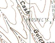
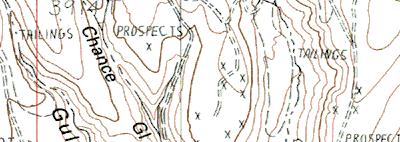
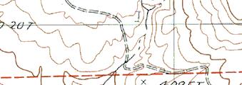
21 BASIN CREEK (WILLOW CREEK BASIN) SUMMER-9 REACH UNIT# TYPE CHAN DIST.(m) COMMENTS NOTE_ESTIMATOR NOTE_NUMERATOR DC T-4547/ DC 74 METAL PIPE PIECES IN STREAM 6 DC 469 RF,TJ/ T-45568/ TRACTOR TIRE IN STREAM 7 PD RF UNNAMED TRIB ON TOPO MAP 8 PD TRIB PUDDLING ON ROADBED MUDDY COW PATH, HEAVY USE 9 PD 69 SS/ COILED HOSES RIGHT BANK RI 698 PLASTIC PIPE IN RIGHT BANK LP 7 U OIL DRUM ON LEFT BANK 6 PD 753 WL MOURNING DOVES 8 DC (4) COWS 9 DP 78 ARTIFICIAL GRAVEL DAM SS 78 H=.3M ARTIFICIAL DAM DP 785 T=8.5C AT : DC 85 /TJ T-45649/496 3 DC UNNAMED TRIB ON TOPO MAP GRASS, CATTLE TRAILS 4 DC 933 WL T-45649/496 (4) CHUKARS 5 PD 98 WL FLOCK OF CHUKARS 3 LP 68 T-45644/ PD 48 TJ/,WL T=6.5C AT : FLOCK OF BIRDS 3 DC UNNAMED TRIB ON TOPO MAP DEAD GRASS & SAGEBRUSH 34 DC 458 METAL CRANK IN STREAM 37 PD 586 /TJ,FC T-45757/49683, CATTLE 38 PD UNNAMED TRIB ON TOPO MAP CATTLE TRAMPLED GRASS, MUD 39 PD 686 WL () RATTLESNAKES 43 RB 85 T-45636/ RB 88 LA/ PLASTIC PIPE BANK RIGHT 53 SB 978 H=.4M 56 DC PLASTIC CULVERT/PIPE BANK LEFT 6 RB 76 T-45684/ RB 3 CORRUGATED METAL IN STREAM 63 SS 6 H=.6M, DAM DIVERTING WATER ARTIFICIAL DAM 64 DP 8 UD/ T-45653L/497376L 65 RI OLD FENCE BANK LEFT 67 RB 49 /SS ESTIMATED DUE TO BRUSH 68 RI 68 T=4.5C AT : 69 MX 38 TJ/ TRIB T-45539/49756 ESTIMATED - TOO BRUSHY 7 DC UNNAMED TRIB ON MAP 7 SB 353 H=.7M 74 MX 48 CS MINE TAILINGS, ESTIMATED BRUSH 75 SB 43 H=.7M 76 GL 44 PLASTIC BARREL BANK LEFT 77 RB 53 JUNIPERS ON HILLSLOPES ESTIMATED - TOO BRUSHY 78 PD 59 TJ/ ESTIMATED - TOO BRUSHY 79 DC 66 T-45545L/49767L, GRASS 8 PD 653 T-4557/ PD 69 U8-84 ESTIMATED - TOO BRUSHY 84 MX 335 T-45558L/4988L END SURVEY BY ROCK SPRING
 Stream Habitat")


22 Basin Creek (Willow Creek Basin) Stream Habitat Survey -Summer 9 Basin Creek-Reach - View from Road Looking Downstream Basin Creek- Looking from Road at Mining Operation Basin Creek-Reach Basin Photo Basin Creek-Reach -u4- Looking Upstream Basin Creek-Reach -u-artificial Dam Basin Creek- Reach -u3-dry Tributary
 Stream Habitat")


23 Basin Creek (Willow Creek Basin) Stream Habitat Survey -Summer 9 Basin Creek-Reach -u4-looking Upstream Basin Creek-Reach -u3-eroding Bank Basin Creek-Reach -u38-cattle in Riparian Basin Creek-Reach -u4-looking Upstream Basin Creek-Reach -u64-diversion to Canal Basin Creek-Reach -u69-brushy Stream Channel


24 Basin Creek (Willow Creek Basin) Stream Habitat Survey -Summer 9 Basin Creek-Reach -u78-looking Upstream-Very Brushy Basin Creek-Reach -u84- Downstream Reach view from Road Basin Creek-Looking Upstream from Public Land- Backhoe on Bank Basin Creek-Looking Upstream Public Land- View of Mine


 STREAM")

 998,")

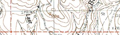

25 4 5 m 4 5 m 4 53 m 4 54 m 49 5 m 49 6 m 49 7 m 49 8 m 49 9 Reach Reach Start of Survey End of Survey unit # m 49 6 m 49 7 m 49 8 m 4 5 m 4 5 m 4 53 m 4 54 m Name: MORMON BASIN Date: /3/9 Scale: inch equals 6 feet Location: 4559 E N NAD 83 Caption: BASIN CREEK (WILLOW CREEK BASIN-SUMMER 9) STREAM HABITAT SURVEY Copyright (C) 998, Maptech, Inc.
REACH 1 T37S-R14W-S07NW
 OREGON DEPT. FISH AND WILDLIFE HABITAT INVENTORY Report Date: 3//3 Survey Date: 7/3/ REACH T37S-R4W-S7NW REACH Valley and Channel Summary Narrow Valley Floor Steep V-shape Moderate V-shape Open V-shape
ODFW AQUATIC INVENTORY PROJECT RESTORATION MONITORING STREAM HABITAT REPORT. Peggy Kavanagh, Trevan Cornwell TOLEDO SOUTH Coast Range Lora Tennant
 ODFW AQUATIC INVENTORY PROJECT RESTORATION MONITORING STREAM HABITAT REPORT STREAM: GCG: 2-MC SITE ID: 489 BASIN: YAQUINA TREATMENT DATE: 24 SURVEY DATE: 2/27/24 SURVEY CREW: USGS MAPS: ECOREGION: REPORT
ODFW AQUATIC INVENTORY PROJECT STREAM REPORT
 ODFW AQUATIC INVENTORY PROJECT STREAM REPORT STREAM: BASIN: South Fork Mill Creek Mill Creek / Columbia River DATES: September 7 9, 5 SURVEY CREW: REPORT PREPARED BY: Brian Bangs / LaNoah Babcock Staci
ODFW AQUATIC INVENTORY PROJECT STREAM REPORT. Jennifer Bock / Eric Evans / LaNoah Babcock HUC NUMBER: LLID:
 ODFW AQUATIC INVENTORY PROJECT STREAM REPORT STREAM: BASIN: South Fork Dixie Creek Burnt River DATES: July 6, September 3-7, SURVEY CREW: REPORT PREPARED BY: Jennifer Bock / Eric Evans / LaNoah Babcock
ODFW AQUATIC INVENTORY PROJECT OREGON PLAN FOR SALMON & WATERSHEDS STREAM RESTORATION HABITAT REPORT
 ODFW AQUATIC INVENTORY PROJECT OREGON PLAN FOR SALMON & WATERSHEDS STREAM RESTORATION HABITAT REPORT STREAM: BASIN: SURVEY TYPE: Munson Creek (NC-342) Tillamook River Post-Tx DATE: February 2, 28 SURVEY
ODFW AQUATIC INVENTORY PROJECT OREGON PLAN FOR SALMON & WATERSHEDS STREAM RESTORATION HABITAT REPORT
 ODFW AQUATIC INVENTORY PROJECT OREGON PLAN FOR SALMON & WATERSHEDS STREAM RESTORATION HABITAT REPORT STREAM: BASIN: SURVEY TYPE: South Sister Creek (U-5) Smith River Pre-Tx DATE: January 7, 4 SURVEY CREW:
A Guide To Interpreting Stream Survey Reports. Scott C. Foster Charles H. Stein Kim K. Jones. Edited by Patricia A. Bowers
 A Guide To Interpreting Stream Survey Reports Scott C. Foster Charles H. Stein Kim K. Jones Edited by Patricia A. Bowers Aquatic Inventories Project Natural Production Program Oregon Department of Fish
DETAILED DESCRIPTION OF STREAM CONDITIONS AND HABITAT TYPES IN REACH 4, REACH 5 AND REACH 6.
 DETAILED DESCRIPTION OF STREAM CONDITIONS AND HABITAT TYPES IN REACH 4, REACH 5 AND REACH 6. The Eklutna River was divided into study reaches (figure 1) prior to this site visit. Prominent geologic or
Appendix E Rosgen Classification
 Appendix E Stream Type s Using the morphometric parameters described above, stream reaches are classified into 7 major stream types (Aa+ through G) based on s (1996) criteria. The relevant stream classifications
APPENDIX E. GEOMORPHOLOGICAL MONTORING REPORT Prepared by Steve Vrooman, Keystone Restoration Ecology September 2013
 APPENDIX E GEOMORPHOLOGICAL MONTORING REPORT Prepared by Steve Vrooman, Keystone Restoration Ecology September 2 Introduction Keystone Restoration Ecology (KRE) conducted geomorphological monitoring in
Riparian Assessment. Steps in the right direction... Drainage Basin/Watershed: Start by Thinking Big. Riparian Assessment vs.
 Riparian Assessment vs. Monitoring Riparian Assessment What is a healthy stream? Determine stream/riparian health Determine change or trend, especially in response to mgmt Classification = designation
Rosgen Classification Unnamed Creek South of Dunka Road
 Rosgen Classification Unnamed Creek South of Dunka Road Prepared for Poly Met Mining Inc. September 2013 Rosgen Classification Unnamed Creek South of Dunka Road Prepared for Poly Met Mining Inc. September
APPENDIX A REACH DECRIPTIONS. Quantico Creek Watershed Assessment April 2011
 APPENDIX A REACH DECRIPTIONS Basin 615, South Fork of Quantico Creek - Project Reach Descriptions Reach Name: 615-A Coordinates (NAD 83, Virginia State Plane North): 11796510.57, 6893938.95 to 11801555.79,
C. STUDENT FIELD DATA SHEETS
 C. STUDENT FIELD DATA SHEETS Student Name Date Time Stream Location Parameter to find Your Group s Results Units trial trial average Transparency cm Water Temperature Air Temperature Weather N sunny N
Dan Miller + Kelly Burnett, Kelly Christiansen, Sharon Clarke, Lee Benda. GOAL Predict Channel Characteristics in Space and Time
 Broad-Scale Models Dan Miller + Kelly Burnett, Kelly Christiansen, Sharon Clarke, Lee Benda GOAL Predict Channel Characteristics in Space and Time Assess Potential for Fish Use and Productivity Assess
Fish Passage at Road Crossings
 Fish Passage at Road Crossings 1 Crossing Design Workshop Outline 1:00 to 2:00 Intro, Design Overview, Channel Width 2:00 to 2:15 Break 2:15 to 3:15 No-Slope, Stream Simulation Design 3:15 to 3:30 Break
Habitat Assessment. Peggy Compton UW-Extension Water Action Volunteers Program Coordinator
 Habitat Assessment Peggy Compton UW-Extension Water Action Volunteers Program Coordinator Adapted from a presentation by Jean Unmuth, Water Quality Biologist, WI DNR dnr.wi.gov www.uwex.edu erc.cals.wisc.edu
GEOL 652. Poudre River Fieldtrip
 GEOL 652. Poudre River Fieldtrip One of the more difficult variables to measure and/or estimate when studying flow in natural channels is that of roughness. Roughness, usually approximated with Manning
Why Geomorphology for Fish Passage
 Channel Morphology - Stream Crossing Interactions An Overview Michael Love Michael Love & Associates mlove@h2odesigns.com (707) 476-8938 Why Geomorphology for Fish Passage 1. Understand the Scale of the
GENERAL SUMMARY BIG WOOD RIVER GEOMORPHIC ASSESSMENT BLAINE COUNTY, IDAHO
 GENERAL SUMMARY BIG WOOD RIVER GEOMORPHIC ASSESSMENT BLAINE COUNTY, IDAHO Prepared For Trout Unlimited 300 North Main Street, Hailey, Idaho, 83333 Prepared By P. O. Box 8578, 140 E. Broadway, Suite 23,
Aquifer an underground zone or layer of sand, gravel, or porous rock that is saturated with water.
 Aggradation raising of the streambed by deposition that occurs when the energy of the water flowing through a stream reach is insufficient to transport sediment conveyed from upstream. Alluvium a general
PolyMet NorthMet Project
 RS 26 Draft-01 December 8, 2005 RS26 Partridge River Level 1 Rosgen Geomorphic Survey Rosgen Classification Partridge River from Headwaters to Colby Lake Prepared for PolyMet NorthMet Project December
Fluvial Driven Alluvial Fans
 Fluvial Driven Alluvial Fans Restoration Project Evaluations - Examples from the Russian and Napa River Watersheds Mia Docto Masters Thesis UC Berkeley 1. Basic Fan Description 2. Fluvial Driven Fan Characteristics
Limitation to qualitative stability indicators. the real world is a continuum, not a dichotomy ~ 100 % 30 % ~ 100 % ~ 40 %
 Stream Stability Assessment & BEHI Surveys Joe Rathbun MDEQ Water Resources Division rathbunj@michigan.gov 517--373 517 373--8868 Stability Stream can transport its water and sediment inputs without changing
Conceptual Model of Stream Flow Processes for the Russian River Watershed. Chris Farrar
 Conceptual Model of Stream Flow Processes for the Russian River Watershed Chris Farrar Several features of creeks affect the interactions between surface and groundwater. This conceptual model uses the
Rapid Geomorphic Assessments: RGA s
 Establishing Current Reference Conditions Rates and concentrations of suspended-sediment transport vary over time and space due to factors such as precipitation characteristics and discharge, geology,
Elevation (ft) Slope ( ) County CONDITION CATEGORY. Parameter Natural Condition Slightly impacted Moderately Impacted Heavily Impacted
 Slope ( ) County CONDITION CATEGORY. Parameter Natural Condition Slightly impacted Moderately Impacted Heavily Impacted") Version: 8/25/14 Meadow Name Date : / / MM DD YYYY GPS Location:. N. W GPS Datum (e.g., WGS 84, NAD 27) Elevation (ft) Slope ( ) County Watershed (HUC8) Landowner USGS Quad Name Observers: 7.5 or 15 (circle
Version: 8/25/14 Meadow Name Date : / / MM DD YYYY GPS Location:. N. W GPS Datum (e.g., WGS 84, NAD 27) Elevation (ft) Slope ( ) County Watershed (HUC8) Landowner USGS Quad Name Observers: 7.5 or 15 (circle
Case Study 14. Rocky Creek Vented Box Culvert Ford
 Case Study. Rocky Creek Vented Box Culvert Ford Location West Central Arkansas. Ouachita National Forest; Oden Ranger District. Rocky Creek crossing on Forest Road 887 (Muddy Gibbs Road). Crossing Description
!"#$%&&'()*+#$%(,-./0*)%(!
*+#$%(,-./0*)%(!") 8:30 Sign in Hoosic River Revival Coalition!"#$%&&'()*+#$%(,-./0*)%(! 12-#30+4/#"5-(60 9:00 Welcome and Introductions 9:15 Goals for Today s Program: A Description of the Planning Process 9:30 First Session:
8:30 Sign in Hoosic River Revival Coalition!"#$%&&'()*+#$%(,-./0*)%(! 12-#30+4/#"5-(60 9:00 Welcome and Introductions 9:15 Goals for Today s Program: A Description of the Planning Process 9:30 First Session:
SALMONID HABITAT ASSESSMENT UPPER MILLER CREEK
 SALMONID HABITAT ASSESSMENT UPPER MILLER CREEK GRADY RANCH, MARIN COUNTY, CALIFORNIA July 2011 Prepared for: Skywalker Properties Ltd. 5858 Lucas Valley Road Nicasio, California 94946 Prepared by: WRA,
Appendix III-A Descriptions of Channel Habitat Types
 Appendix III-A Descriptions of Channel Habitat Types Table of Contents Channel Habitat Typing Background... 3 Small Estuarine Channel (ES)... 7 Large Estuarine Channel (EL)... 9 Low Gradient Large Floodplain
Stream Classification
 Stream Classification Why Classify Streams? Communication Tool Describe Existing Conditions & Trends Describe Restoration Goals Research Tool Morphologic Stream Classification Systems Schumm (1977) Alluvial
HAW CREEK, PIKE COUNTY, MISSOURI-TRIB TO SALT RIVER ERODING STREAM THREATHENING COUNTY ROAD #107, FOURTEEN FT TALL ERODING BANK WITHIN 4 FT OF THE
 HAW CREEK, PIKE COUNTY, MISSOURI-TRIB TO SALT RIVER ERODING STREAM THREATHENING COUNTY ROAD #107, FOURTEEN FT TALL ERODING BANK WITHIN 4 FT OF THE ROAD, PROJECT CONSTRUCTED IN 1 DAY, MARCH 10, 2009 BY
CR AAO Bridge. Dead River Flood & Natural Channel Design. Mitch Koetje Water Resources Division UP District
 CR AAO Bridge Dead River Flood & Natural Channel Design Mitch Koetje Water Resources Division UP District Old County Road AAO Bridge Map courtesy of Marquette County Silver Lake Basin McClure Basin
Case Study 2: Twenty-mile Creek Rock Fords
 Case Study : Twenty-mile Creek Rock Fords Location Crossing Description Washington. Okanagan National Forest. Methow Valley Ranger District. Chewuch river basin, East Chewuch Road. The Twenty-mile Creek
Upper Mississippi River Basin Environmental Management Program Workshop
 Presentation to the Upper Mississippi River Basin Environmental Management Program Workshop by Michael Rodgers River Engineer US Army Corps of Engineers, St. Louis District August 17, 2007 Engineering
Assignment 1. Measuring River Characteristics- Vernon Creek. Applied Fluvial Geomorphology Field Techniques EESc 435
 Assignment 1 Measuring River Characteristics- Vernon Creek Applied Fluvial Geomorphology Field Techniques EESc 435 Amanda Jardine 30100093 Jaime McDonald 14177083 Erica Massey 50870088 April 28, 2012 Introduction
Little Blackfoot TPA 2009 Sediment and Habitat Assessment QAQC Review March 9, 2010
 Little Blackfoot TPA 2009 Sediment and Habitat Assessment QAQC Review March 9, 2010 1.0 PROJECT OVERVIEW Sediment and habitat monitoring in the Little Blackfoot TPA was conducted in July of 2009 as outlined
Stream Simulation: A Simple Example
 Stream Simulation: A Simple Example North Thompson Creek, CO Paul T. Anderson U.S.D.A. Forest Service Here s How We Started May 2011 2-1 USDA-Forest Service Here s How We Finished Forest Service Aquatic
Forest Service AOP Meeting Objectives of Stream Simulation: Examples and Talking Points
 Forest Service AOP Meeting Objectives of Stream Simulation: Examples and Talking Points Traci Sylte, P.E. Hydrology/Fluvial Geomorphology Lolo National Forest Is It True? Are Road Crossings a Dam with
ADDRESSING GEOMORPHIC AND HYDRAULIC CONTROLS IN OFF-CHANNEL HABITAT DESIGN
 ADDRESSING GEOMORPHIC AND HYDRAULIC CONTROLS IN OFF-CHANNEL HABITAT DESIGN Conor Shea - Hydrologist U.S. Fish and Wildlife Service Conservation Partnerships Program Arcata, CA Learning Objectives Examine
Gully Erosion Part 1 GULLY EROSION AND ITS CAUSES. Introduction. The mechanics of gully erosion
 Gully Erosion Part 1 GULLY EROSION AND ITS CAUSES Gully erosion A complex of processes whereby the removal of soil is characterised by incised channels in the landscape. NSW Soil Conservation Service,
Assessment. Assessment
 2001 SPRINGBROOK CREEK RESTORATION - THREE YEAR POST-CONSTRUCTION REVIEW - Presented by Bruce Henderson and Andy Harris 2005 River Restoration Northwest Symposium Skamania Lodge, Washington www.hendersonlandservices.com
1.0 Appendix. Appendix A In-stream LWD Data Collection Sheet In Stream LWD Data Collection Stream Site: Coordinates:x y Crew: Date: Dia-4.
 1.0 Appendix Appendix A In-stream LWD Data Collection Sheet In Stream LWD Data Collection Stream Site: Coordinates:x y Crew: Date: Shot ID-1 Shot Id-2 Shot Id-3 Shot Id-4 Tagid LWD Criteria Dia-1 (cm)
Stream Restoration and Environmental River Mechanics. Objectives. Pierre Y. Julien. 1. Peligre Dam in Haiti (deforestation)
") Stream Restoration and Environmental River Mechanics Pierre Y. Julien Malaysia 2004 Objectives Brief overview of environmental river mechanics and stream restoration: 1. Typical problems in environmental
Stream Restoration and Environmental River Mechanics Pierre Y. Julien Malaysia 2004 Objectives Brief overview of environmental river mechanics and stream restoration: 1. Typical problems in environmental
Flood and Stream Restoration
 2 3 4 Pedestrian bridge under construction 3 CSPs perched on DS side Large area of sand deposition Bottom layer of gabions has been scoured out large bar of gabion stone Gabions slumping bank slope failure
Design and Construction
 Design and Construction Stream Simulation With power point slides shamelessly stolen from: Forest Service AOP Training Course Bob Gubernick Paul Anderson John Kattell USDA Forest Service Interim Directive
Step 5: Channel Bed and Planform Changes
 Step 5: Channel Bed and Planform Changes When disturbed, streams go through a series of adjustments to regain equilibrium with the flow and sediment supply of their watersheds. These adjustments often
BUREAU OF CLEAN WATER. Appendix C Biological Field Methods C1. Habitat Assessment DECEMBER 2013
 BUREAU OF CLEAN WATER Appendix C Biological Field Methods C1. Assessment DECEMBER 2013 HABITAT ASSESSMENT The Department has adopted the habitat assessment methods outlined in EPA s Rapid Bioassessment
Stream Geomorphology. Leslie A. Morrissey UVM July 25, 2012
 Stream Geomorphology Leslie A. Morrissey UVM July 25, 2012 What Functions do Healthy Streams Provide? Flood mitigation Water supply Water quality Sediment storage and transport Habitat Recreation Transportation
SECTION G SEDIMENT BUDGET
 SECTION G SEDIMENT BUDGET INTRODUCTION A sediment budget has been constructed for the for the time period 1952-2000. The purpose of the sediment budget is to determine the relative importance of different
Business. Meteorologic monitoring. Field trip? Reader. Other?
 Business Meteorologic monitoring Field trip? Reader Other? Classification Streams Characterization Discharge measurements Why classify stream channels? Why Classify Stream Channels? Provides a common language
Session C1 - Applying the Stream Functions Pyramid to Geomorphic Assessments and Restoration Design
 University of Massachusetts - Amherst ScholarWorks@UMass Amherst International Conference on Engineering and Ecohydrology for Fish Passage International Conference on Engineering and Ecohydrology for Fish
YUBA COUNTY WATER AGENCY
 YUBA COUNTY WATER AGENCY Representative Site Selection Above Englebright Reservoir Stream Fish, Aquatic BMI, Aquatic Mollusks Yuba County Water Agency Yuba River Development Project FERC Project No. 2246
The River Restoration Centre therrc.co.uk. Understanding Fluvial Processes: supporting River Restoration. Dr Jenny Mant
 The River Restoration Centre therrc.co.uk Understanding Fluvial Processes: supporting River Restoration Dr Jenny Mant Jenny@therrc.co.uk Understanding your catchment Hydrology Energy associated with the
Carex nudata, a native sedge, as facilitator of restoration goals following passive restoration
 Carex nudata, a native sedge, as facilitator of restoration goals following passive restoration Middle Fork John Day River, Oxbow Conservation Area Confederated Tribes of the Warm Springs Matthew Goslin
Why Stabilizing the Stream As-Is is Not Enough
 Why Stabilizing the Stream As-Is is Not Enough Several examples of alternatives to the County s design approach have been suggested. A common theme of these proposals is a less comprehensive effort focusing
Natural Shoreline Landscapes on Michigan Inland Lakes
 Natural Shoreline Landscapes on Michigan Inland Lakes Excerpts from Chapters 2 and 3 Photo Photo by Jane by Jane Herbert Herbert Did you know? Twenty-four species of amphibians, 25 species of reptiles,
Field Observations and One-Dimensional Flow Modeling of Summit Creek in Mack Park, Smithfield, Utah
 Intermountain Center for River Rehabilitation and Restoration, Utah State University 31 July 2018 Field Observations and One-Dimensional Flow Modeling of Summit Creek in Mack Park, Smithfield, Utah I.
Step 6: Rapid Habitat Assessment (RHA)
") Step 6: Rapid Habitat Assessment (RHA) Background Physical processes, combined with chemical constituents and biological interactions, are what determine biological productivity and diversity; and, in
Step 6: Rapid Habitat Assessment (RHA) Background Physical processes, combined with chemical constituents and biological interactions, are what determine biological productivity and diversity; and, in
UPPER KETTLE CREEK FISH HABITAT CONSERVATION PLAN TRIBUTARIES ADDENDUM
 UPPER KETTLE CREEK FISH HABITAT CONSERVATION PLAN TRIBUTARIES ADDENDUM For: Kettle Creek Watershed Association and Trout Unlimited March 2005 1000 Commerce Park Drive Williamsport, PA 17701 Phone (570)
Black Gore Creek 2013 Sediment Source Monitoring and TMDL Sediment Budget
 Black Gore Creek 2013 Sediment Source Monitoring and TMDL Sediment Budget Prepared for: Prepared By: - I. Introduction The Black Gore Creek Total Maximum Daily Load (TMDL) was developed in collaboration
Restoring Meanders to Straightened Rivers 1.7 Reconnecting remnant meanders
 .7 Reconnecting remnant meanders River Little Ouse Location - Thetford, Norfolk TL87082 Date of construction - 994 Length 900m Cost 5,000 Maximum extent of flooding during winter floods BTO boundary Small
CASE STUDIES. Introduction
 Introduction The City of Winston-Salem faces the challenge of maintaining public infrastructure (e.g., water and sewer lines, storm drains, roads, culverts and bridges) while minimizing the potential impacts
Appendix G. Meso-Habitat Surveys. DRAFT Annual Technical Report
 Appendix G Meso-Habitat Surveys DRAFT Annual Technical Report Draft March 2010 1.0 Introduction 1 2 3 4 5 6 1.0 Introduction The following appendix includes a report provided by the California Department
Upper Truckee River Restoration Lake Tahoe, California Presented by Brendan Belby Sacramento, California
 Upper Truckee River Restoration Lake Tahoe, California Presented by Brendan Belby Sacramento, California Mike Rudd (Project Manager), Charley Miller & Chad Krofta Declines in Tahoe s Water Clarity The
Lower South Fork McKenzie River Floodplain Enhancement Project
 Lower South Fork McKenzie River Floodplain Enhancement Project McKenzie River Ranger District Willamette National Forest Project Location The project is located in the South Fork McKenzie River Watershed,
STUDY PERFORMANCE REPORT
 STUDY PERFORMANCE REPORT State: Michigan Project No.: F-80-R-8 Study No.: 230702 Title: Effects of sediment traps on Michigan river channels Period Covered: October 1, 2006 to September 30, 2007 Study
7.1 COMPONENTS OF THE HABITAT CHARACTERIZATION 7.2 HABITAT SAMPLING LOCATIONS WITHIN THE SAMPLING REACH 7.3 LOGISTICS AND WORK FLOW 7
 7 PHYSICAL HABITAT CHARACTERIZATION...97 7.1 COMPONENTS OF THE HABITAT CHARACTERIZATION...101 7.2 HABITAT SAMPLING LOCATIONS WITHIN THE SAMPLING REACH...103 7.3 LOGISTICS AND WORK FLOW...105 7.4 THALWEG
Kootenai River Habitat Restoration Program Update
 Kootenai River Habitat Restoration Program Update Kootenai Tribe of Idaho Kootenai Valley Resource Initiative November 19, 2012 Bonners Ferry, Idaho Changes to Kootenai Basin Beaver trapping Floodplain
Tom Ballestero University of New Hampshire. 1 May 2013
 Tom Ballestero University of New Hampshire 1 May 2013 1 Hydrology 2 Basic Hydrology Low flows most common Flows that fill the stream to the banks and higher are much less common Filling the stream to the
River Restoration and Rehabilitation. Pierre Y. Julien
 River Restoration and Rehabilitation Pierre Y. Julien Department of Civil and Environmental Engineering Colorado State University Fort Collins, Colorado River Mechanics and Sediment Transport Lima Peru
Geomorphic Assessment of the Middle and Lower Swan Lake Watershed, Calhoun Division of Two Rivers National Wildlife Refuge.
 Geomorphic Assessment of the Middle and Lower Swan Lake Watershed, Calhoun Division of Two Rivers National Wildlife Refuge Report Figures 33 34 Figure 1. Location of Middle and Lower Swan Lake watersheds
NORTHUMBERLAND COUNTY, PA
 QUAKER RUN Stream and Wetland Restoration As-Built Completion Report and First Year Monitoring Data Coal Township NORTHUMBERLAND COUNTY, PA Upstream Before Upstream After Prepared for: COAL TOWNSHIP 805
Fine sediment in pools: an index of how sediment is affecting a stream channel
 R-5 Fish Habitat Relationship Technical Bulletin Number 6 December 1991 O Fine sediment in pools: an index of how sediment is affecting a stream channel Tom Lisle Sue Hilton Redwood Sciences Laboratory
Appendix F Channel Grade Control Structures
 Stream Simulation Appendix F Channel Grade Control Structures This appendix briefly describes permanent grade control structures that are sometimes needed in the upstream and/or downstream reaches adjacent
Carmel River Bank Stabilization at Rancho San Carlos Road Project Description and Work Plan March 2018
 Carmel River Bank Stabilization at Rancho San Carlos Road Project Description and Work Plan March 2018 EXISTING CONDITION The proposed Carmel River Bank Stabilization at Rancho San Carlos Road Project
Historical channel change on the Upper Gila River, Arizona and New Mexico in response to anthropogenic modifications and extreme floods
 Historical channel change on the Upper Gila River, Arizona and New Mexico in response to anthropogenic modifications and extreme floods www.archives.gov www.paztcn.wr.usgs.gov wrh.noaa.gov Upper Gila River
Learning Objectives: I can identify and interpret river flows and directions.
 Learning Objectives: I can identify and interpret river flows and directions. Bellringer Review: Check for Understanding Questions: 1 2 What Are The Key Parts Of A River s Anatomy? In your data notebooks
Addressing the Impact of Road-Stream Crossing Structures on the Movement of Aquatic Organisms
 Scott Jackson University of Massachusetts Amherst Addressing the Impact of Road-Stream Crossing Structures on the Movement of Aquatic Organisms Dams Sub-standard Culverts Excessive Velocities Inlet Drop
SCOPE OF PRESENTATION STREAM DYNAMICS, CHANNEL RESTORATION PLANS, & SEDIMENT TRANSPORT ANALYSES IN RELATION TO RESTORATION PLANS
 DESIGN METHODS B: SEDIMENT TRANSPORT PROCESSES FOR STREAM RESTORATION DESIGN PETER KLINGEMAN OREGON STATE UNIVERSITY CIVIL ENGINEERING DEPT., CORVALLIS 2 ND ANNUAL NORTHWEST STREAM RESTORATION DESIGN SYMPOSIUM
APPENDIX 4B FOOTHILL YELLOW-LEGGED FROG SURVEY DATASHEETS AND STANDARD OPERATING PROCEDURES (BASED ON SELTENRICH AND POOL,
 APPENDIX 4B FOOTHILL YELLOW-LEGGED FROG SURVEY DATASHEETS AND STANDARD OPERATING PROCEDURES (BASED ON SELTENRICH AND POOL, 2002) February 2004 PacifiCorp Foothill Yellow-Legged Frog Klamath River Visual
Technical Memorandum. To: From: Copies: Date: 10/19/2017. Subject: Project No.: Greg Laird, Courtney Moore. Kevin Pilgrim and Travis Stroth
 Technical Memorandum To: From: Greg Laird, Courtney Moore Kevin Pilgrim and Travis Stroth 5777 Central Avenue Suite 228 Boulder, CO 80301 www.otak.com Copies: [Electronic submittal] Date: 10/19/2017 Subject:
-- Lessons from a successful salmon stream and estuary relocation on Gravina Island
 Re-inventing Government Creek -- Lessons from a successful salmon stream and estuary relocation on Gravina Island Jon Houghton, Ph.D. and Derek Ormerod, M.S., P.E. - Pentec Environmental/Hart Crowser,
PENNSYLVANIA DEPARTMENT OF TRANSPORTATION ENGINEERING DISTRICT 3-0
 PENNSYLVANIA DEPARTMENT OF TRANSPORTATION ENGINEERING DISTRICT 3-0 LYCOMING COUNTY S.R.15, SECTION C41 FINAL HYDROLOGIC AND HYDRAULIC REPORT STEAM VALLEY RUN STREAM RELOCATION DATE: June, 2006 REVISED:
Long Valley Meadow Restoration Project
 Long Valley Meadow Restoration Project USDA Forest Service Mogollon Rim Ranger District Coconino National Forest Coconino County, Arizona T13N, R9E, Section 12 and T13N, R10E, Sections 6 and 7 Gila and
Ways To Identify Background Verses Accelerated Erosion
 Ways To Identify Background Verses Accelerated Erosion Establish Background Condition From Old Ground Photos, Aerial Photos, and Maps Compare Rate Over Time At the Same Location, or for Reaches Channel
Avoiding Geohazards in the Mid-Atlantic Highlands by Using Natural Stream Principles
 Avoiding Geohazards in the Mid-Atlantic Highlands by Using Natural Stream Principles J. Steven Kite, WVU Neal Carte, WVDOT Will Harman, Michael Baker Corp. Donald D. Gray, WVU Photo: W. Gillespie North
Clyde River Landslide
 Clyde River Landslide Department of Geology, Perkins Hall, University of Vermont, Burlington, VT 05405 Abstract: This paper investigates a landslide on the Clyde River in Newport, Vermont. The landslide
Island Design. UMRS EMP Regional Workshop. Presentation for the
 Island Design Presentation for the UMRS EMP Regional Workshop by Jon Hendrickson Hydraulic Engineer Regional Technical Specialist, Water Quality and Habitat Restoration August 17 19, 2005 Project Delivery
APPENDIX B WORKSHEETS & EXHIBITS
 APPENDIX B WORKSHEETS & EXHIBITS A worksheet provides the designer a representation of a measure that allows for input of specific design criteria. The plan designer will be required to assess field conditions
Figure A 6. Floodplain and instream geomorphic units associated with the Bedrock-controlled, elongate discontinuous floodplain river style.
 Figure A 6. Floodplain and instream geomorphic units associated with the Bedrock-controlled, elongate discontinuous floodplain river style. This figure represents the naturally adjusting variant within
Rapid Assessment of Stream Conditions Along Length (RASCAL) Protocol
 Protocol") Draft Draft Rapid Assessment of Stream Conditions Along Length (RASCAL) Protocol Overview: The RASCAL procedure; Rapid Assessment of Stream Conditions Along Length, has been modified from the NRCS Stream
Draft Draft Rapid Assessment of Stream Conditions Along Length (RASCAL) Protocol Overview: The RASCAL procedure; Rapid Assessment of Stream Conditions Along Length, has been modified from the NRCS Stream
Waterbury Dam Disturbance Mike Fitzgerald Devin Rowland
 Waterbury Dam Disturbance Mike Fitzgerald Devin Rowland Abstract The Waterbury Dam was completed in October 1938 as a method of flood control in the Winooski Valley. The construction began in April1935
4 CHANNEL HABITAT TYPING
 Upper Williamson River Watershed Assessment 4 CHANNEL HABITAT TYPING INTRODUCTION METHODS Classification of stream channels within a watershed is an important part of understanding the inherent spatial
MORRO BAY WATERSHED STEELHEAD RESTORATION PLANNING PROJECT
 MORRO BAY WATERSHED STEELHEAD RESTORATION PLANNING PROJECT STREAM INVENTORY REPORT DAIRY CREEK, 2001 Prepared to: Coastal San Luis Resource Conservation District MORRO BAY WATERSHED STEELHEAD RESTORATION
6.11 Naas River Management Unit
 6.11 Naas River Management Unit 6.11.1 Site 41 Issue: Bed and bank erosion Location: E 0685848 N 6058358 Waterway: Naas River Management Unit: Naas River Facing downstream from Bobeyan Rd bridge Facing
Surface Water and Stream Development
 Surface Water and Stream Development Surface Water The moment a raindrop falls to earth it begins its return to the sea. Once water reaches Earth s surface it may evaporate back into the atmosphere, soak
Streams. Stream Water Flow
 CHAPTER 14 OUTLINE Streams: Transport to the Oceans Does not contain complete lecture notes. To be used to help organize lecture notes and home/test studies. Streams Streams are the major geological agents
Case Study 8. North Fork Nooksack River In-channel Project
 Case Study 8 Project Overview The North Fork Nooksack In-channel project was developed cooperatively between the USDA Forest Service and the Nooksack Salmon Enhancement Association (NSEA), with the objectives