Estimated Sediment Volume: Bridge Street Dam Impoundment, Royal River, Yarmouth, Maine
|
|
|
- Clinton Waters
- 5 years ago
- Views:
Transcription
1 University of Southern Maine USM Digital Commons Publications Casco Bay Estuary Partnership (CBEP) 2015 Estimated Sediment Volume: Bridge Street Dam Impoundment, Royal River, Yarmouth, Maine Stantec Follow this and additional works at: Recommended Citation Stantec. (2015). Estimated Sediment Volume: Bridge Street Dam Impoundment, Royal River, Yarmouth, Maine. Portland, ME: University of Southern Maine, Muskie School of Public Service, Casco Bay Estuary Partnership. This Report is brought to you for free and open access by the Casco Bay Estuary Partnership (CBEP) at USM Digital Commons. It has been accepted for inclusion in Publications by an authorized administrator of USM Digital Commons. For more information, please contact

2 Estimated Sediment Volume: Bridge Street Dam Impoundment Estimated Volume of Accumulated Sediment Bridge Street Dam Impoundment Royal River, Yarmouth, Maine Prepared for: Steven S. Johnson, P.E. Town Engineer Yarmouth, Maine Prepared by: Stantec Consulting Services Inc. 30 Park Drive Topsham, Maine 04086
 for the account of the Town of Yarmouth, Maine (the Client ). Any reliance on this document by any third party is strictly prohibited.")

3 Sign-off Sheet This document entitled Estimated Sediment Volume: Bridge Street Dam Impoundment was prepared by Stantec Consulting Services Inc. ( Stantec ) for the account of the Town of Yarmouth, Maine (the Client ). Any reliance on this document by any third party is strictly prohibited. The material in it reflects Stantec s professional judgment in light of the scope, schedule and other limitations stated in the document and in the contract between Stantec and the Client. The opinions in the document are based on conditions and information existing at the time the document was published and do not take into account any subsequent changes. In preparing the document, Stantec did not verify information supplied to it by others. Any use which a third party makes of this document is the responsibility of such third party. Such third party agrees that Stantec shall not be responsible for costs or damages of any kind, if any, suffered by it or any other third party as a result of decisions made or actions taken based on this document. Prepared by Michael Chelminski, P.E. (signature) Reviewed by David Huntress, P.E. (signature)
4 Table of Contents 1.0 INTRODUCTION BACKGROUND INFORMATION FIELD STUDY PREPARATION FOR FIELD STUDY FIELD STUDY DATA ANALYSIS SEDIMENT COMPOSITION RESULTS AND DISCUSSION SEDIMENT COMPOSITION AND DISTRIBUTION ACCUMULATION OF SEDIMENT IN YARMOUTH HARBOR LIST OF FIGURES Figure 1: Sediment Probing Transects and Probing Locations LIST OF APPENDICES APPENDIX A FIELD NOTES... A.1
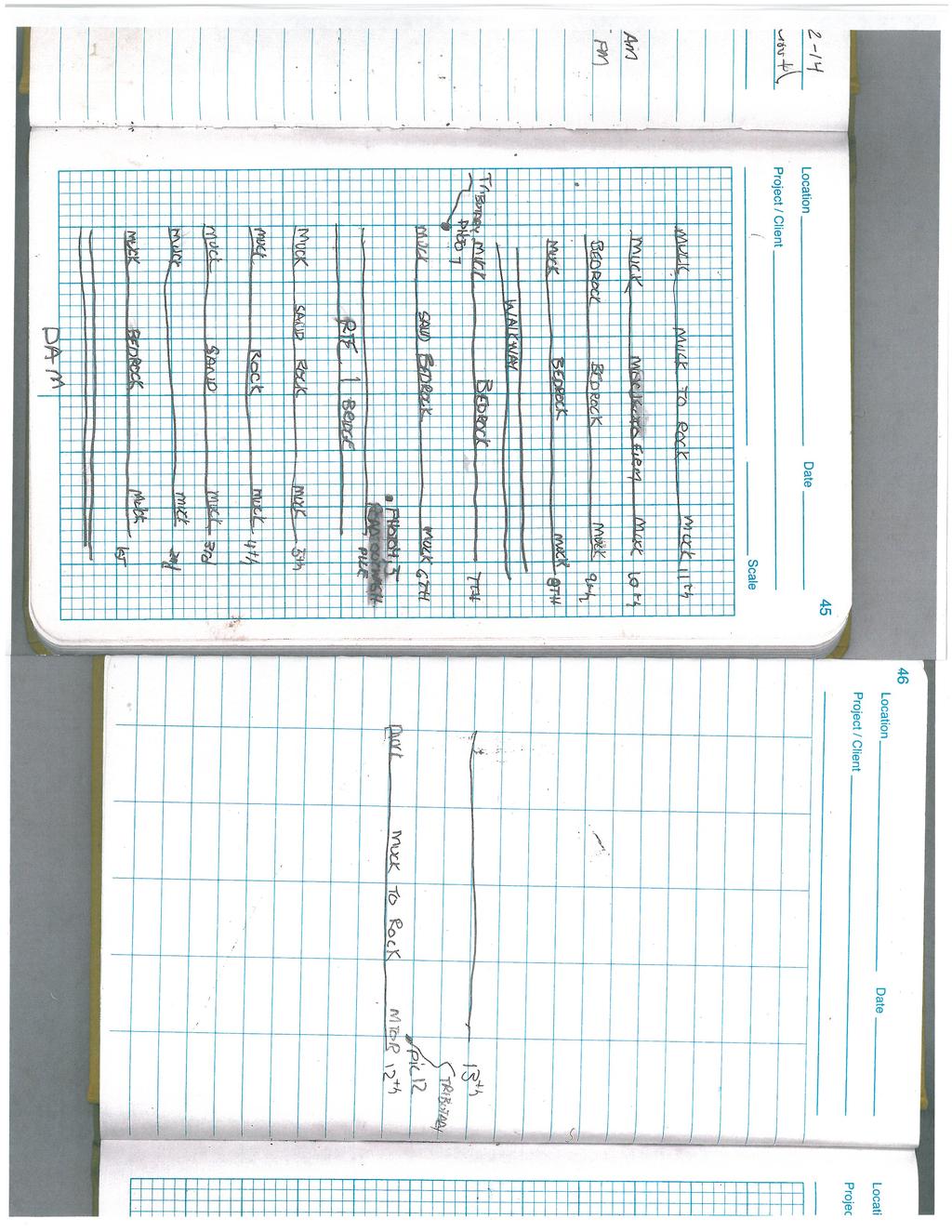
5 Introduction 1.0 INTRODUCTION This report presents information on the composition, volume, and potential mobility of accumulated sediment in the Bridge Street Dam impoundment on the Royal River in Yarmouth, Maine, and was prepared for the Town of Yarmouth, Maine (Town) by Stantec Consulting Services Inc. (Stantec). The objective of this study is to provide estimates of the volume and composition of accumulated sediment in the Bridge Street Dam impoundment. The dam impoundment, which is the area that is influenced by the backwater created by the dam, extends from the dam upstream to Middle Falls on the Royal River, and has an overall length of approximately 2,000 feet (ft). The normal pool surface area of the impoundment is approximately 9 acres, and the maximum depth of water at the normal pool water surface elevation is approximately 15 ft. 1.1 BACKGROUND INFORMATION Bridge Street Dam is owned by the Town and located approximately 2,000 feet (ft) upstream from the head-of-tide in the Royal River in the vicinity of the East Main Street (State Route 88 Bridge). The Town is evaluating potential alternatives to maintaining the dam, including removal of the dam, and has convened a group of stakeholders to address concerns related to removal of the dam. The primary identified concern to removal of the dam is the potential for remobilization of sediment from the Bridge Street Dam impoundment and transport and deposition of remobilized sediment in the tidally affected reach of the Royal River seaward from the East Main Street and Interstate 295 (I295) bridges. Specific concern associated with remobilization of sediment from the Bridge Street Dam impoundment include 1) the potential for this material to contribute to shoaling in Yarmouth Harbor, and 2) remobilization of environmental contaminants that may be present in the impoundment and deposition of this material in the harbor. Information obtained as part of previous project studies indicate that there is little accumulated sediment in the Bridge Street Dam impoundment, and that impoundment is subject to scour during high-flow events. Factors that may contribute to the apparent lack of accumulation of sediment in this impoundment appear to include: 1) limited transport of coarse sediment (i.e., gravel-size material and larger) into this impoundment, and 2) relatively high-speed flow in the impoundment during high-flow events that continually remobilize finer-grained sediments and deliver them to the downstream reach of the river. Observations during a drawdown of the impoundment appear to support the above mentioned factors, in that relatively shallow bedrock outcrops with little to no accumulated material were observed in areas of the impoundment during the prior drawdown and during a drawdown on November 12, 2014, during the field study described in this report. mrc v:\1956\active\ \report\nov 2014 sediment bridge street dam sediment probing\rpt_ _bridgestreetdam_sedestimate_fnl.docx 1.1
6 Field Study 2.0 FIELD STUDY 2.1 PREPARATION FOR FIELD STUDY Sediment probing locations were established prior to the initiation of field studies to provide approximate locations of 13 survey transects. Prior to the field study, the endpoints of each transect were loaded in into a Global Positioning System (GPS) receiver to facilitate locating the survey transects during the field study. 2.2 FIELD STUDY The field study was performed on Wednesday, November 12, 2014, and coincided with a drawdown of the Bridge Street Dam impoundment. Field surveys were performed by a twoperson crew from a small boat and wading in shallow areas. Sediments were manually probed using a fiberglass survey rod at intervals of approximately 20 ft along 13 transects spaced approximately 150 ft apart along the impoundment, and provided measurements at 109 locations in the impoundment. Sediment depths were recorded as the difference between the measured depth of water and the measured depth-to-refusal based on manually advancing the survey rod into sediment. The horizontal position of probed locations was obtained with a Wide Area Augmentation System-enabled GPS receiver. The locations of the 13 transects across the Bridge Street Dam impoundment are depicted in Figure 1. The survey transects (red lines in Figure 1) are numbered sequentially (1 13) progressing upstream from the dam, and the locations were sediment depths were measured to refusal area depicted (red dots) along each transect. Depths were recorded relative to the water surface during the field studies and not to a specific elevation. The height of the water surface below the right upstream training wall of the fishpass was measured as 4.6 ft prior to the initiation of the sediment probing work at 7:10 AM and as 4.5 ft at 15:15 pm at the completion of the sediment probing field surveys. Of note is that the impoundment drawdown result in exposure of bedrock ledge (Photo 1) upstream from the footbridge over the Royal River along the Beth Condon Memorial Trail. When exposed, this ledge forms the hydraulic control for the upstream reach of the river to the base of Middle Falls and results in higher water surface elevations relative to the reach of the impoundment downstream from the ledge. mrc v:\1956\active\ \report\nov 2014 sediment bridge street dam sediment probing\rpt_ _bridgestreetdam_sedestimate_fnl.docx 2.2

7 Field Study Photo 1: Ledge Upstream from Beth Condon Memorial Trail Footbridge (flow is from right to left) In addition to the measurements of sediment depth in the impoundment, 8 sediment probes were performed at two locations along the left 1 side of the impoundment in areas along the edge of the normal impoundment, including an area of emergent vegetation downstream from the U.S Route 1 Bridge. Probing in these locations was performed using a 4-2 steel rod. These probe locations are depicted as yellow dots in Figure 1. Sediment characteristics were estimated and recorded at selected sediment locations. The sediment characteristics were estimated based on the felt response during the sediment probe and referenced to each location in the field notes and in the codes entered into the GPS receiver at the selected locations. A copy of the field notes is included as Appendix A. Following the sediment probing on November 12, 2014, Stantec canoed the perimeter of the impoundment between Bridge Street Dam and the exposed ledge to observe apparent conditions. Observations during this cruise confirm the presence of accumulations of fine sediment along the margins of the dewatered sediment, including benches that may support emergent vegetation, and a number of areas with localized accumulations of fine sediment (sand). Localized accumulations of fine sediment were observed immediately upstream from the Sparhawk Mill hydroelectric facility trashrack and at two locations where stormwater is discharged to the impoundment. 1 Directionals left and right are based on an observer facing downstream. mrc v:\1956\active\ \report\nov 2014 sediment bridge street dam sediment probing\rpt_ _bridgestreetdam_sedestimate_fnl.docx 2.3

8 Field Study Photo 2: Accumulated Sediment at Stormwater Outfall (left side of river immediately upstream from U.S. Route 1 Bridge) mrc v:\1956\active\ \report\nov 2014 sediment bridge street dam sediment probing\rpt_ _bridgestreetdam_sedestimate_fnl.docx 2.4
9 13 12 FLO W AL ROY R E RIV 9 FL OW ROUTE 1 5 ROU TE 1 AL ROY R E RIV 4 W FLO DRAFT FOR REVIEW ONLY


10 13 12 FLO W AL ROY R E RIV 9 FL OW ROUTE 1 5 ROU TE 1 AL ROY R E RIV 4 W FLO DRAFT FOR REVIEW ONLY
11 Data Analysis 3.0 DATA ANALYSIS The sediment probing data was post-processed to provide graphical depictions of the sediment probing locations in plan and profile along each transect and to estimate the volume of probed sediment. Profiles along the 13 sediment probing transects are depicted in Figure 1 and annotated with the estimated sediment characteristics. The volume of the probed sediment was calculated using a volumetric surface defined by a triangulated irregular network with horizontal coordinates at each probed location with heights at each measurement location represented by the measured sediment depth. The estimated volume of probed material in this volumetric surface is 4,200 cubic yards (CY), which includes approximately 750 CY between Middle Falls and the exposed ledge upstream from the Beth Condon Memorial Trail footbridge and approximately 3,450 CY between the exposed ledge and the dam. Note that this estimate does not include material located outside of the wetted perimeter of the impoundment, such as those points that are depicted as yellow dots on Figure SEDIMENT COMPOSITION The sediment probing identified muck, sand, gravel/cobble/boulder, and bedrock substrate along the probed transects in the impoundment. Probing in the two areas along the left side of the impoundment in areas that are above the normal water surface elevation of the impoundment indicated that fine material is the dominant sediment in these areas. The use of manual probes does not allow for penetration through coarse-grained sediments, such as gravel, cobble, or boulder material. It is therefore estimated that most of the probed material is comprised of fine-grained material (sand or smaller). 4.0 RESULTS AND DISCUSSION Information obtained as part of the sediment probing work indicates that accumulated sediment in the Bridge Street Dam impoundment includes muck, sand, gravel/cobble/boulders, and that the bottom is scoured to bedrock in some locations. In general, depths of accumulated sediment are larger along the margins of the impoundment; this finding suggests that high-speed flows during high-flow events limit accumulation of sediment in the impoundment. As previously noted, the estimated volume of accumulated sediment based on the sediment probing in the impoundment is 4,200 CY. Based on observed localized deposits of fine sediment, it is suggested that a contingency of 20% (840 CY) be added to the estimated volume of accumulate sediment to reflect observed localized sediment deposits, including the observed mrc v:\1956\active\ \report\nov 2014 sediment bridge street dam sediment probing\rpt_ _bridgestreetdam_sedestimate_fnl.docx 4.6
12 Results and Discussion material immediately upstream from the Sparhawk Mill hydroelectric facility trashracks and adjacent to stormwater outfalls and coarse-grained sediment that was not probed. The estimated volume of material based on the 20% contingency is therefore 5,040 CY. The estimated volume of accumulated sediment does not include material located outside of the normal pool limits of the impoundment (i.e., along the margins of the impoundment), including material that was probed and denoted by yellow dots in Figure 1. Observations of the project reach of the Royal River during high-flow conditions suggest that most of the finer-grained material in the Bridge Street Dam impoundment would be remobilized during a higher flow event (e.g., 10-year return-interval flow) if the dam is removed. However, it is expected that remobilization of this material would occur over multiple high-flow events. Based on information obtained as part of previous project studies, it is expected that material that is remobilized from the Bridge Street Dam impoundment during high-flow events would be replaced by material that is delivered to the impoundment from the upstream reach of the Royal River. 4.1 SEDIMENT COMPOSITION AND DISTRIBUTION Most of the probed material in the Bridge Street Dam impoundment was located along the edges of the impoundment and is comprised of fine-grained material (sand or smaller). The apparent dominance of fine-grained material is consistent with the size of material that is expected to be regularly transported downstream at the East Elm Street Dam approximately 1,300 ft upstream from Middle Falls. It is not expected that the volume of accumulated sediment in the Bridge Street Dam may change in response to high-flow events, but it is expected that the existing volume of sediment is representative of the typical volume of sediment. The basis for this determination is that Bridge Street Dam has been in place for over 100 years. It is not expected that the volume of accumulated sediment varies seasonally. It is expected that most of the fine-grained sediment could be remobilized following removal of the dam, but the duration of time during which remobilization would occur is indeterminate. Note, however, that the sediment probing did not extend substantially landward from the edge of the impoundment. While some additional sediment along the impoundment margins may be subject to remobilization, sediment in areas which are persistently vegetated, such as the area along the left bank between the U.S Route 1 Bridge and the dam, may not be subject to ready remobilization. mrc v:\1956\active\ \report\nov 2014 sediment bridge street dam sediment probing\rpt_ _bridgestreetdam_sedestimate_fnl.docx 4.7
13 Results and Discussion 4.2 ACCUMULATION OF SEDIMENT IN YARMOUTH HARBOR Approximately 60,000 CY of material was removed from Yarmouth Harbor during dredge work in the fall of 2014, and others have estimated that the average accumulation rate of sediment in the harbor is approximately 10,000 CY per year. Based on these estimates, the estimated volume of sediment in the Bridge Street Dam impoundment constitutes approximately 10% of the volume of the recent dredge or a half-year of the average annual accumulation of sediment. Coarse grained materials, including gravel, cobble, and boulder-size material, could be remobilized from the Bridge Street Dam impoundment if the dam is removed. However, it is not expected that this material could substantially contribute to sedimentation in the harbor because the larger material is expected to accumulate in the immediate vicinity of the Interstate 295 Bridge. mrc v:\1956\active\ \report\nov 2014 sediment bridge street dam sediment probing\rpt_ _bridgestreetdam_sedestimate_fnl.docx 4.8
14 Appendices
15 Appendix A Field Notes Appendix A FIELD NOTES A.1
16
Highland Lake Bathymetric Survey
 Highland Lake Bathymetric Survey Final Report, Prepared For: The Town of Highland Lake 612 Lakeshore Drive Oneonta, AL 35121 Prepared By: Tetra Tech 2110 Powers Ferry Road SE Suite 202 Atlanta, GA 30339
MaxDepth Aquatics, Inc.
 MaxDepth Aquatics, Inc. Bathymetry of Mirror Pond From Newport Bridge to Galveston Bridge Prepared for the City of Bend By Joseph Eilers & Benn Eilers MaxDepth Aquatics, Inc. Bend, OR June 2005 INTRODUCTION
Bishopville Prong Study
 Bathymetric and Sediment Assessment in the Bishopville Prong of St. Martin River Darlene V. Wells, Richard A. Ortt, Jr., and Stephen Van Ryswick Funded by MCBP 2011-2012 Implementation Grant Objectives
STRUCTURAL STABILITY ASSESSMENT
 STRUCTURAL STABILITY ASSESSMENT CFR 257.73(d) Bottom Ash Pond Complex Cardinal Plant Brilliant, Ohio October, 2016 Prepared for: Cardinal Operating Company Cardinal Plant Brilliant, Ohio Prepared by: Geotechnical
Appendix O. Sediment Transport Modelling Technical Memorandum
 Appendix O Sediment Transport Modelling Technical Memorandum w w w. b a i r d. c o m Baird o c e a n s engineering l a k e s design r i v e r s science w a t e r s h e d s construction Final Report Don
Feasibility Study for Potential Removal of McLane & Goldman Dams Souhegan River, Milford, NH. Public Kick-off Meeting
 Feasibility Study for Potential Removal of McLane & Goldman Dams Souhegan River, Milford, NH Public Kick-off Meeting Mark Wamser Gomez and Sullivan Engineers, P.C. 603-428-4960 Aug 16, 2010 Agenda Opening
STUDY PERFORMANCE REPORT
 STUDY PERFORMANCE REPORT State: Michigan Project No.: F-80-R-8 Study No.: 230702 Title: Effects of sediment traps on Michigan river channels Period Covered: October 1, 2006 to September 30, 2007 Study
B-1. Attachment B-1. Evaluation of AdH Model Simplifications in Conowingo Reservoir Sediment Transport Modeling
 Attachment B-1 Evaluation of AdH Model Simplifications in Conowingo Reservoir Sediment Transport Modeling 1 October 2012 Lower Susquehanna River Watershed Assessment Evaluation of AdH Model Simplifications
Do you think sediment transport is a concern?
 STREAM RESTORATION FRAMEWORK AND SEDIMENT TRANSPORT BASICS Pete Klingeman 1 What is Your Restoration Project Like? k? Do you think sediment transport is a concern? East Fork Lewis River, WA Tidal creek,
Project Proposal. Lyme Brook. Newcastle-under-Lyme. 3 rd July 2015
 Project Proposal Lyme Brook Newcastle-under-Lyme 3 rd July 2015 Contents Page 1.0 Introduction... 1.0 2.0 Background and rationale... 2.0 3.0 Proposed measures... 5 4.0 Summary of Recommendations... 10
Strategies for managing sediment in dams. Iwona Conlan Consultant to IKMP, MRCS
 Strategies for managing sediment in dams Iwona Conlan Consultant to IKMP, MRCS 1 Sediment trapping by dams Active storage capacity Dead storage coarse material (bed load) Fine materials (suspension) Francis
Technical Memorandum. To: From: Copies: Date: 10/19/2017. Subject: Project No.: Greg Laird, Courtney Moore. Kevin Pilgrim and Travis Stroth
 Technical Memorandum To: From: Greg Laird, Courtney Moore Kevin Pilgrim and Travis Stroth 5777 Central Avenue Suite 228 Boulder, CO 80301 www.otak.com Copies: [Electronic submittal] Date: 10/19/2017 Subject:
Geomorphology Geology 450/750 Spring Fluvial Processes Project Analysis of Redwood Creek Field Data Due Wednesday, May 26
 Geomorphology Geology 450/750 Spring 2004 Fluvial Processes Project Analysis of Redwood Creek Field Data Due Wednesday, May 26 This exercise is intended to give you experience using field data you collected
Why Geomorphology for Fish Passage
 Channel Morphology - Stream Crossing Interactions An Overview Michael Love Michael Love & Associates mlove@h2odesigns.com (707) 476-8938 Why Geomorphology for Fish Passage 1. Understand the Scale of the
Seagrass Transplantation & Environmental & Marine Consulting Services, Inc. Drew Campbell, Vice President & Lead Scientst.
 Indian River Lagoon Symposium Seagrass Transplantation & Project Considerations Environmental & Marine Consulting Services, Inc. Drew Campbell, Vice President & Lead Scientst March 26 th, 2013 Regulatory
Sediment Transport Mechanism and Grain Size Distributions in Stony Bed Rivers. S.FUKUOKA 1 and K.OSADA 2
 Sediment Transport Mechanism and Grain Size Distributions in Stony Bed Rivers S.FUKUOKA 1 and K.OSADA 1 Professor, Research and Development Initiative, Chuo-University, 1-13-7 Kasuga Bunkyo-ku, Tokyo,
Fish Passage at Road Crossings
 Fish Passage at Road Crossings 1 Crossing Design Workshop Outline 1:00 to 2:00 Intro, Design Overview, Channel Width 2:00 to 2:15 Break 2:15 to 3:15 No-Slope, Stream Simulation Design 3:15 to 3:30 Break
Appendix G. Meso-Habitat Surveys. DRAFT Annual Technical Report
 Appendix G Meso-Habitat Surveys DRAFT Annual Technical Report Draft March 2010 1.0 Introduction 1 2 3 4 5 6 1.0 Introduction The following appendix includes a report provided by the California Department
Geomorphic Importance of Winter Peak Flows and Annual Snowmelt Hydrographs in a Sierra Nevada Boulder-Bedrock River
 Geomorphic Importance of Winter Peak Flows and Annual Snowmelt Hydrographs in a Sierra Nevada Boulder-Bedrock River Scott McBain and Bill Trush McBain & Trush, Inc. Clavey River and Cherry Creek vicinity
Coarse Sediment Augmentation on Regulated Rivers. Scott McBain McBain & Trush, Inc.
 Coarse Sediment Augmentation on Regulated Rivers Scott McBain McBain & Trush, Inc. scott@mcbaintrush.com Components Some geomorphic and ecological considerations Conceptual approach at understanding augmentation
HISTORY OF CONSTRUCTION FOR EXISTING CCR SURFACE IMPOUNDMENT PLANT GASTON ASH POND 40 CFR (c)(1)(i) (xii)
(1)(i) (xii)") HISTORY OF CONSTRUCTION FOR EXISTING CCR SURFACE IMPOUNDMENT PLANT GASTON ASH POND 40 CFR 257.73(c)(1)(i) (xii) (i) Site Name and Ownership Information: Site Name: E.C. Gaston Steam Plant Site Location:
HISTORY OF CONSTRUCTION FOR EXISTING CCR SURFACE IMPOUNDMENT PLANT GASTON ASH POND 40 CFR 257.73(c)(1)(i) (xii) (i) Site Name and Ownership Information: Site Name: E.C. Gaston Steam Plant Site Location:
DETAILED DESCRIPTION OF STREAM CONDITIONS AND HABITAT TYPES IN REACH 4, REACH 5 AND REACH 6.
 DETAILED DESCRIPTION OF STREAM CONDITIONS AND HABITAT TYPES IN REACH 4, REACH 5 AND REACH 6. The Eklutna River was divided into study reaches (figure 1) prior to this site visit. Prominent geologic or
Lake Sedimentation Survey of Siloam Springs State Park Lake, Adams County, Illinois
 Contract Report 567 Lake Sedimentation Survey of Siloam Springs State Park Lake, Adams County, Illinois by Richard L. Allgire Office of Sediment & Wetland Studies Prepared for the Illinois Department of
Appendix I. Dredged Volume Estimates. Draft Contractor Document: Subject to Continuing Agency Review
 Appendix I Dredged Volume Estimates Draft Contractor Document: Subject to Continuing Agency Review Interoffice Correspondence Date: April 6, 2007 To: L. Bossi (WHI) Copy: S. Thompson (WHI), B. Fidler (NNJ)
Chapter 5 CALIBRATION AND VERIFICATION
 Chapter 5 CALIBRATION AND VERIFICATION This chapter contains the calibration procedure and data used for the LSC existing conditions model. The goal of the calibration effort was to develop a hydraulic
Technical Memorandum No Sediment Model
 Pajaro River Watershed Study in association with Technical Memorandum No. 1.2.9 Sediment Model Task: Development of Sediment Model To: PRWFPA Staff Working Group Prepared by: Gregory Morris and Elsie Parrilla
GEOL 652. Poudre River Fieldtrip
 GEOL 652. Poudre River Fieldtrip One of the more difficult variables to measure and/or estimate when studying flow in natural channels is that of roughness. Roughness, usually approximated with Manning
Stop 1: Marmot Dam Stop 1: Marmot Dam
 Stop 1: Marmot Dam Stop 1: Marmot Dam Following the removal of Marmot Dam in 2007, the fate of the reservoir sediments has been monitored through a series of surveys and sediment transport measurements.
June 9, R. D. Cook, P.Eng. Soils Engineer Special Services Western Region PUBLIC WORKS CANADA WESTERN REGION REPORT ON
 PUBLIC WORKS CANADA WESTERN REGION REPORT ON GEOTECHNICAL INVESTIGATION PROPOSED MARTIN RIVER BRIDGE MILE 306.7 MACKENZIE HIGHWAY Submitted by : R. D. Cook, P.Eng. Soils Engineer Special Services Western
Physical modeling to guide river restoration projects: An Overview
 Physical modeling to guide river restoration projects: An Overview Scott Dusterhoff¹, Leonard Sklar², William Dietrich³, Frank Ligon¹, Yantao Cui¹, and Peter Downs¹ ¹Stillwater Sciences, 2855 Telegraph
Appendix G.19 Hatch Report Pacific NorthWest LNG Lelu Island LNG Maintenance Dredging at the Materials Offloading Facility
 Appendix G.19 Hatch Report Pacific NorthWest LNG Lelu Island LNG Maintenance Dredging at the Materials Offloading Facility Project Memo H345670 To: Capt. David Kyle From: O. Sayao/L. Absalonsen December
Dam Removal Analysis Guidelines for Sediment
 A review of: Dam Removal Analysis Guidelines for Sediment Joe Rathbun (Retired) rathbunj@sbcglobal.net Some Potential Sediment Issues Reservoir restoration Downstream water quality Downstream deposition
RESERVOIR DRAWDOWN RATES/RESERVOIR DRAWDOWN TEST Iron Gate, Copco (I & II), and JC Boyle Dams
, and JC Boyle Dams") TECHNICAL MEMORANDUM No. 1 TO: Michael Bowen California Coastal Conservancy Geotechnical & Earthquake Engineering Consultants CC: Eric Ginney Philip Williams & Associates PREPARED BY: Paul Grant SUBJECT:
TECHNICAL MEMORANDUM No. 1 TO: Michael Bowen California Coastal Conservancy Geotechnical & Earthquake Engineering Consultants CC: Eric Ginney Philip Williams & Associates PREPARED BY: Paul Grant SUBJECT:
ADDENDA #1 CONTRACT # C May 3, 2013 Page 1 of 1
 State of California Natural Resources Agency Edmund G. Brown Jr., Governor DEPARTMENT OF PARKS AND RECREATION Major General Anthony L. Jackson, USMC (Ret), Director ADDENDA #1 CONTRACT # C1247040 May 3,
Technical Memorandum
 2855 Telegraph Avenue, Suite 4, Berkeley, CA 9475, Phone (51) 848-898, Fax (51) 848-8398 Technical Memorandum Date: September 6, 27 To: Mr. Michael Bowen, Project Manager From: Yantao Cui, Ph.D., Hydraulic
Island Design. UMRS EMP Regional Workshop. Presentation for the
 Island Design Presentation for the UMRS EMP Regional Workshop by Jon Hendrickson Hydraulic Engineer Regional Technical Specialist, Water Quality and Habitat Restoration August 17 19, 2005 Project Delivery
Subcommittee on Sedimentation Draft Sediment Analysis Guidelines for Dam Removal
 Subcommittee on Sedimentation Draft Sediment Analysis Guidelines for Dam Removal August 4, 2011 Jennifer Bountry, M.S., P.E. Tim Randle, M.S., P.E., D.WRE. Blair Greimann, Ph.D., P.E. Sedimentation and
Why Stabilizing the Stream As-Is is Not Enough
 Why Stabilizing the Stream As-Is is Not Enough Several examples of alternatives to the County s design approach have been suggested. A common theme of these proposals is a less comprehensive effort focusing
R.M.HARW & ASSOCIATES LTD. GEOTECHNICAL INVESTIGATION PROPOSED BRIDGE SITE. HELAVA CREEKl MILE MACKENZIE HIGHWAY E-2510 OCTOBER 16, 1973
 El R.M.HARW & ASSOCIATES LTD. GEOTECHNICAL INVESTIGATION PROPOSED BRIDGE SITE HELAVA CREEKl MILE 616.4 MACKENZIE HIGHWAY E-2510 OCTOBER 16, 1973 R,M,HARDV & ASSOCIATES LTD. CONSULTING ENGINEERING & TESTING
SAVANNAH HARBOR EXPANSION BANK EROSION STUDY UPDATE
 CESAS-EN-GS SAVANNAH HARBOR EXPANSION BANK EROSION STUDY UPDATE GEOTECHNICAL AND HTRW BRANCH SOILS SECTION CITY FRONT, BIGHT SECTION, FORT PULASKI & NORTH TYBEE ISLAND GEORGIA 23 June 2011 CESAW-TS-EG
Technical Review of Pak Beng Hydropower Project (1) Hydrology & Hydraulics and (2) Sediment Transport & River Morphology
 Hydrology & Hydraulics and (2) Sediment Transport & River Morphology") Technical Review of Pak Beng Hydropower Project (1) Hydrology & Hydraulics and (2) Sediment Transport & River Morphology The 2 nd Regional Stakeholder Forum The Pak Beng Hydropower Project 5 th May 2017
Technical Review of Pak Beng Hydropower Project (1) Hydrology & Hydraulics and (2) Sediment Transport & River Morphology The 2 nd Regional Stakeholder Forum The Pak Beng Hydropower Project 5 th May 2017
3301 East 120 th Avenue Assited Living & Memory Care
 UTILITY REPORT FOR 3301 East 120 th Avenue Assited Living & Memory Care 1 st Submittal January 23, 2016 2 nd Submittal March 04, 2016 Prepared for: 3301 E. 120 th Ave, LLC. 8200 E. Maplewood Ave., Suite
Black Gore Creek 2013 Sediment Source Monitoring and TMDL Sediment Budget
 Black Gore Creek 2013 Sediment Source Monitoring and TMDL Sediment Budget Prepared for: Prepared By: - I. Introduction The Black Gore Creek Total Maximum Daily Load (TMDL) was developed in collaboration
SAN FRANCISCO DISTRICT INFORMATION REQUESTED FOR VERIFICATION OF CORPS JURISDICTION
 DEPARTMENT OF THE ARMY SAN FRANCISCO DISTRICT, U.S. ARMY CORPS OF ENGINEERS 1455 MARKET STREET SAN FRANCISCO, CALIFORNIA 94103-1398 SAN FRANCISCO DISTRICT INFORMATION REQUESTED FOR VERIFICATION OF CORPS
Appendix F Channel Grade Control Structures
 Stream Simulation Appendix F Channel Grade Control Structures This appendix briefly describes permanent grade control structures that are sometimes needed in the upstream and/or downstream reaches adjacent
Jasper Beach, Machiasport, Maine
 Maine Geologic Facts and Localities June, 2000 Jasper Beach, Machiasport, Maine 44 o 38 30.28 N, 67 o 22 31.96 W Text by Joesph T. Kelley, Department of Agriculture, Conservation & Forestry 1 Map by USGS
Vegetation effects on river hydraulics. Johannes J. (Joe) DeVries David Ford Consulting Engineers, Inc. Sacramento, CA
 DeVries David Ford Consulting Engineers, Inc. Sacramento, CA") Vegetation effects on river hydraulics Johannes J. (Joe) DeVries David Ford Consulting Engineers, Inc. Sacramento, CA jjdevries@ford-consulting.com SAC05 D2P31 RM 99.0L VIEW UPSTREAM AT UPSTREAM END DWR
Vegetation effects on river hydraulics Johannes J. (Joe) DeVries David Ford Consulting Engineers, Inc. Sacramento, CA jjdevries@ford-consulting.com SAC05 D2P31 RM 99.0L VIEW UPSTREAM AT UPSTREAM END DWR
Old Stone Sewer Main Street
 Bangor Landing Bangor, Maine Case Study-Sediment Sediment Investigation Maine Department of Environmental Protection City of Bangor, with RMT, Inc. Site Location and Local Site Features 1 Bangor Landing
Lake Forest Mapping ANALYSIS OF SHOALING AND POOL VOLUMES
 ANALYSIS OF SHOALING AND POOL VOLUMES Center for Applied Coastal Engineering & Science UNIVERSITY OF SOUTH ALABAMA 150 JAGUAR DRIVE, MOBILE, AL 36688 i Analysis of Shoaling and Pool Volumes Final Report
6 PREPARING THE SAMPLING AND ANALYSIS PLAN (SAP)
") 6 PREPARING THE SAMPLING AND ANALYSIS PLAN (SAP) Once the required numbers of DMMUs and field samples have been calculated and a dredging plan conceived, a sampling plan must be developed. The DMMUs and
6 PREPARING THE SAMPLING AND ANALYSIS PLAN (SAP) Once the required numbers of DMMUs and field samples have been calculated and a dredging plan conceived, a sampling plan must be developed. The DMMUs and
INFLOW DESIGN FLOOD CONTROL SYSTEM PLAN 40 C.F.R. PART PLANT YATES ASH POND 2 (AP-2) GEORGIA POWER COMPANY
 GEORGIA POWER COMPANY") INFLOW DESIGN FLOOD CONTROL SYSTEM PLAN 40 C.F.R. PART 257.82 PLANT YATES ASH POND 2 (AP-2) GEORGIA POWER COMPANY EPA s Disposal of Coal Combustion Residuals from Electric Utilities Final Rule (40 C.F.R.
INFLOW DESIGN FLOOD CONTROL SYSTEM PLAN 40 C.F.R. PART 257.82 PLANT YATES ASH POND 2 (AP-2) GEORGIA POWER COMPANY EPA s Disposal of Coal Combustion Residuals from Electric Utilities Final Rule (40 C.F.R.
3. MARINE HABITAT RESTORATION
 Feasibility Study for Restoration of Titlow Lagoon Fish Passage South Puget Sound Salmon Enhancement Group 3. MARINE HABITAT RESTORATION Marine habitat restoration at Titlow Park could include restoration
Summary of Hydraulic and Sediment-transport. Analysis of Residual Sediment: Alternatives for the San Clemente Dam Removal/Retrofit Project,
 Appendix N SUMMARY OF HYDRAULIC AND SEDIMENT-TRANSPORT ANALYSIS OF RESIDUAL SEDIMENT: ALTERNATIVES FOR THE SAN CLEMENTE DAM REMOVAL/RETROFIT PROJECT, CALIFORNIA the San Clemente Dam Removal/Retrofit Project,
Simulating Sediment Transport in the Patapsco River following Dam Removal with Dam Removal Express Assessment Model-1 (DREAM-1)
") Simulating Sediment Transport in the Patapsco River following Dam Removal with Dam Removal Express Assessment Model-1 (DREAM-1) Prepared for Inter-Fluve 362 Atwood Ave., Suite 3 Madison, WI 53714 www.interfluve.com
Simulating Sediment Transport in the Patapsco River following Dam Removal with Dam Removal Express Assessment Model-1 (DREAM-1) Prepared for Inter-Fluve 362 Atwood Ave., Suite 3 Madison, WI 53714 www.interfluve.com
Annual transport rates at two locations on the fore-slope.
 Sediment Transport by Currents Fore-slope Sediment transport rates and sediment concentrations were computed from the hydrodynamic model runs as well as from direct measurements of current velocities at
A STUDY OF LOCAL SCOUR AT BRIDGE PIERS OF EL-MINIA
 A STUDY OF LOCAL SCOUR AT BRIDGE PIERS OF EL-MINIA Dr. Gamal A. Sallam 1 and Dr. Medhat Aziz 2 ABSTRACT Bridges are critical structures that require a substantial investment to construct and serve an important
J.B. Shaw and D. Mohrig
 GSA DATA REPOSITORY 2014008 J.B. Shaw and D. Mohrig Supplementary Material Methods Bathymetric surveys were conducted on 26 June- 4 July, 2010 (Fig. 2A), 7 March, 2011 (Fig. 2B), 11-12 August, 2011 (Figs.
Sessom Creek Sand Bar Removal HCP Task 5.4.6
 Sessom Creek Sand Bar Removal HCP Task 5.4.6 Prepared by: Dr. Thomas Hardy Texas State University Dr. Nolan Raphelt Texas Water Development Board January 6, 2013 DRAFT 1 Introduction The confluence of
Aquifer an underground zone or layer of sand, gravel, or porous rock that is saturated with water.
 Aggradation raising of the streambed by deposition that occurs when the energy of the water flowing through a stream reach is insufficient to transport sediment conveyed from upstream. Alluvium a general
EAGLES NEST AND PIASA ISLANDS
 EAGLES NEST AND PIASA ISLANDS HABITAT REHABILITATION AND ENHANCEMENT PROJECT MADISON AND JERSEY COUNTIES, ILLINOIS ENVIRONMENTAL MANAGEMENT PROGRAM ST. LOUIS DISTRICT FACT SHEET I. LOCATION The proposed
CFD Modeling for Structure Designs in Environmental Impacts Mitigation
 CFD Modeling for Structure Designs in Environmental Impacts Mitigation June 05 Navid Nekouee, Hugo Rodriguez and Steven Davie Environmental Impact Mitigation Design Savannah Harbor Expansion Project (SHEP)
LAKE FOREST MAPPING STUDY
 LAKE FOREST MAPPING STUDY ANALYSIS OF SHOALING AND POOL VOLUMES Bret M. Webb, PhD, PE, DCE August 18, 2016 Mobile Bay National Estuary Program Project Implementation Committee Meeting Presentation Map
Standards for Soil Erosion and Sediment Control in New Jersey May 2012
 STANDARD FOR SEDIMENT BASIN Definition A barrier, dam, excavated pit, or dugout constructed across a waterway or at other suitable locations to intercept and retain sediment. Basins created by construction
ENGINEERING APPROACHES TO SHORELINE PLACEMENT FROM COAST TO COAST
 ENGINEERING APPROACHES TO SHORELINE PLACEMENT FROM COAST TO COAST 237 237 237 217 217 217 200 200 200 0 0 0 163 163 163 131 132 122 80 119 27 252 174.59 83 36 118 110 135 120 112 92 56 62 102 130 Comparing
Materials. Use materials meeting the following.
 208.01 Section 208. SOIL EROSION AND SEDIMENTATION CONTROL 208.01 Description. Install and maintain erosion and sedimentation controls to minimize soil erosion and to control sedimentation from affecting
Considerations for Mechanical Dredging, Hydraulic Dredging and Mechanical Dewatering of Sediments
 Considerations for Mechanical Dredging, Hydraulic Dredging and Mechanical Dewatering of Sediments Authors: Jerry Vetter & Eric Zeigler Contractor s Perspective Previous Dredging and Dewatering Projects
Black Gore Creek Sediment Source Monitoring and TMDL Sediment Budget
 Black Gore Creek 2012 Sediment Source Monitoring and TMDL Sediment Budget Prepared for: The Eagle River Watershed Council Prepared By: RiverRestoration.org - I. Introduction Interstate 70 is a major highway
APPENDIX E. GEOMORPHOLOGICAL MONTORING REPORT Prepared by Steve Vrooman, Keystone Restoration Ecology September 2013
 APPENDIX E GEOMORPHOLOGICAL MONTORING REPORT Prepared by Steve Vrooman, Keystone Restoration Ecology September 2 Introduction Keystone Restoration Ecology (KRE) conducted geomorphological monitoring in
Addressing the Impact of Road-Stream Crossing Structures on the Movement of Aquatic Organisms
 Scott Jackson University of Massachusetts Amherst Addressing the Impact of Road-Stream Crossing Structures on the Movement of Aquatic Organisms Dams Sub-standard Culverts Excessive Velocities Inlet Drop
Appendix K.2: Sediment Management Excerpt from South Orange County Hydromodification Management Plan
 Appendix K.2: Sediment Management Excerpt from South Orange County Hydromodification Management Plan 4 Sediment Supply Management Requirements Permit Order R9-2013-0001 as amended by Order No. R9-2015-0001Section
Estimating Remedial Volumes for a GLLA Project on the Milwaukee River
 Estimating Remedial Volumes for a GLLA Project on the Milwaukee River Mike Ciarlo, Jamie Beaver, Mike Powell, Jason Byler EA Engineering, Science, and Technology, Inc. Marsha Burzynski, William Fitzpatrick
Red River Levee Panel
 Red River Levee Panel Mississippi River Commission Monday, August 9, 2017 Red River Levees in LA & AR NONE along TX & OK Boarder Red River Levee Issues Caddo Levee Cherokee Park Authorization Bossier Levee
~ W 89 CONTENTS J-1 J-1 J-6 J-7 J-9 J-10 J-10 J-10
 15 W 89 J-1. J-2. J-3. J-4. J-5. J-6 J-7. J-8. CONTENTS Introduction... Stable Slope Method... Example 1... Armor Bed Method... Example 2...*.... Dominant Discharge... Bed Material Gradation... Numerical
Two-Dimensional Simulation of Truckee River Hydrodynamics
 Two-Dimensional Simulation of Truckee River Hydrodynamics by Stephen H. Scott PURPOSE: The purpose of this Coastal and Hydraulics Engineering Technical Note (CHETN) is to demonstrate the use of multidimensional
ADDRESSING GEOMORPHIC AND HYDRAULIC CONTROLS IN OFF-CHANNEL HABITAT DESIGN
 ADDRESSING GEOMORPHIC AND HYDRAULIC CONTROLS IN OFF-CHANNEL HABITAT DESIGN Conor Shea - Hydrologist U.S. Fish and Wildlife Service Conservation Partnerships Program Arcata, CA Learning Objectives Examine
Stream Simulation: A Simple Example
 Stream Simulation: A Simple Example North Thompson Creek, CO Paul T. Anderson U.S.D.A. Forest Service Here s How We Started May 2011 2-1 USDA-Forest Service Here s How We Finished Forest Service Aquatic
State Water Survey Division SURFACE WATER SECTION
 State Water Survey Division SURFACE WATER SECTION AT THE UNIVERSITY OF ILLINOIS Illinois Department of Energy and Natural Resources SWS Miscellaneous Publication 88 SEDIMENTATION OF POOL 19 ON THE MISSISSIPPI
Eastlake Assited Living & Memory Care
 UTILITY REPORT FOR Eastlake Assited Living & Memory Care 1 st Submittal January 23, 2016 2 nd Submittal March 04, 2016 June 7, 2016 Final Submittal August 08, 2016 Prepared for: 3301 E. 120 th Ave, LLC.
Birecik Dam & HEPP Downstream River Arrangement R. Naderer, G. Scharler Verbundplan GmbH, 5021 Salzburg, Austria
 Birecik Dam & HEPP Downstream River Arrangement R. Naderer, G. Scharler Verbundplan GmbH, 5021 Salzburg, Austria e-mail: scharlerg@verbund.co.at Abstract Birecik Dam & HEPP on the Euphrates river in Turkey
Sandy Point Beach, Cousins Island, Yarmouth, Maine
 Maine Geologic Facts and Localities April, 2008 Sandy Point Beach, Cousins Island, Yarmouth, Maine 43 o 46 25.46 N, 70 o 8 44.84 W Text by Tom Weddle, Department of Agriculture, Conservation & Forestry
Evaluation of Geomorphic Effects of Removal of Marmot and Little Sandy Dams and Potential Impacts on Anadromous Salmonids
 PRELIMINARY FINAL Evaluation of Geomorphic Effects of Removal of Marmot and Little Sandy Dams and Potential Impacts on Anadromous Salmonids Prepared for: Portland General Electric 121 SW Salmon Street
PENNSYLVANIA DEPARTMENT OF TRANSPORTATION ENGINEERING DISTRICT 3-0
 PENNSYLVANIA DEPARTMENT OF TRANSPORTATION ENGINEERING DISTRICT 3-0 LYCOMING COUNTY S.R.15, SECTION C41 FINAL HYDROLOGIC AND HYDRAULIC REPORT STEAM VALLEY RUN STREAM RELOCATION DATE: June, 2006 REVISED:
Preliminary Geotechnical Evaluation Gooseberry Point Pedestrian Improvements Whatcom County, Washington SITE AND PROJECT DESCRIPTION
 File No. 12-100 Geotechnical & Earthquake Engineering Consultants Mr. Kevin Brown, P.E. Gray & Osborne, Inc. 3710 168 th Street NE, Suite B210 Arlington, Washington 98223 Subject: Draft Report Preliminary
Special Public Notice
 Special Public Notice Applicability: General Public Date: June 3, 2014 The purpose of this public notice is to inform you of existing guidance and policy contained in Regulatory Guidance Letter 05-04 concerning
Appendix G.18 Hatch Report Pacific NorthWest LNG Lelu Island LNG Potential Impacts of the Marine Structures on the Hydrodynamics and Sedimentation
 Appendix G.18 Hatch Report Pacific NorthWest LNG Lelu Island LNG Potential Impacts of the Marine Structures on the Hydrodynamics and Sedimentation Patterns Project Memo H345670 To: Capt. David Kyle From:
Lake Worth Lagoon Hydrographic Survey Report
 C-51 Canal Sediment Trap Lake Worth Lagoon Hydrographic Survey Report July 11, 2013 South Florida Water Management District 3301 Gun Club Road West Palm Beach, Florida 33406 Table of Contents Background...
SCOPE OF PRESENTATION STREAM DYNAMICS, CHANNEL RESTORATION PLANS, & SEDIMENT TRANSPORT ANALYSES IN RELATION TO RESTORATION PLANS
 DESIGN METHODS B: SEDIMENT TRANSPORT PROCESSES FOR STREAM RESTORATION DESIGN PETER KLINGEMAN OREGON STATE UNIVERSITY CIVIL ENGINEERING DEPT., CORVALLIS 2 ND ANNUAL NORTHWEST STREAM RESTORATION DESIGN SYMPOSIUM
17-20 November 2007 Incidental Take Monitoring Methodology and Results
 Sample Site Selection Protocol 17-20 November 2007 Incidental Take Monitoring Methodology and Results On 16 November 2007, the U.S. Fish and Wildlife Service (USFWS) provided the USACE Mobile District
Lower Susquehanna River Integrated Sediment & Nutrient Monitoring Program
 Lower Susquehanna River Integrated Sediment & Nutrient Monitoring Program Presented at the Chesapeake Bay Program Scientific and Technical Advisory Committee (STAC) Workshop January 13, 2016 Background
Hydro One (Sept 2014) Hydro One (Sept 2014) Hydro One (Sept 2014)
 Hydro One (Sept 2014) Hydro One (Sept 2014)") TABLE 1 WELL CONSTRUCTION DETAILS MOE WWR No Well ID Location Installation Date Status Easting Coordinates Northing Source Elevation Screened Interval Screened Material Borehole Well Stick-up Ground Top
TABLE 1 WELL CONSTRUCTION DETAILS MOE WWR No Well ID Location Installation Date Status Easting Coordinates Northing Source Elevation Screened Interval Screened Material Borehole Well Stick-up Ground Top
Habitat Assessment. Peggy Compton UW-Extension Water Action Volunteers Program Coordinator
 Habitat Assessment Peggy Compton UW-Extension Water Action Volunteers Program Coordinator Adapted from a presentation by Jean Unmuth, Water Quality Biologist, WI DNR dnr.wi.gov www.uwex.edu erc.cals.wisc.edu
Michael Walsworth, Ryan Sullivan, Simi Odueyungbo, William Budd
 Michael Walsworth, Ryan Sullivan, Simi Odueyungbo, William Budd Estuarine Environment At first (Pritchard, 1967), an estuary was defined by the salinity of the water. Then by Clifton (1982) as an inlet
NORTHUMBERLAND COUNTY, PA
 QUAKER RUN Stream and Wetland Restoration As-Built Completion Report and First Year Monitoring Data Coal Township NORTHUMBERLAND COUNTY, PA Upstream Before Upstream After Prepared for: COAL TOWNSHIP 805
Illinois State Water Survey Division
 Illinois State Water Survey Division SURFACE WATER SECTION SWS Contract Report 413 AT THE UNIVERSITY OF ILLINOIS SEDIMENTATION SURVEY OF DAWSON LAKE, MORAINE VIEW STATE PARK, MC LEAN COUNTY, ILLINOIS by
!"#$%&&'()*+#$%(,-./0*)%(!
*+#$%(,-./0*)%(!") 8:30 Sign in Hoosic River Revival Coalition!"#$%&&'()*+#$%(,-./0*)%(! 12-#30+4/#"5-(60 9:00 Welcome and Introductions 9:15 Goals for Today s Program: A Description of the Planning Process 9:30 First Session:
8:30 Sign in Hoosic River Revival Coalition!"#$%&&'()*+#$%(,-./0*)%(! 12-#30+4/#"5-(60 9:00 Welcome and Introductions 9:15 Goals for Today s Program: A Description of the Planning Process 9:30 First Session:
SUSTAINABLE SEDIMENT MANAGEMENT
 SUSTAINABLE SEDIMENT MANAGEMENT Shaping our world A company of OUR EXPERTISE Sediments can make or break a Project Numerous examples of dams and reservoirs can be found throughout the world whose live
MAINTENANCE DREDGE BENTHIC ASSESSMENT SUNSET POINT FARM LLC LONG POINT KEY MONROE COUNTY, FLORIDA. Prepared by:
 MAINTENANCE DREDGE BENTHIC ASSESSMENT SUNSET POINT FARM LLC LONG POINT KEY MONROE COUNTY, FLORIDA Prepared by: December 11, 2016 INTRODUCTION The owners of the Sunset Point Farms LLC, located on the northern
COUNCIL POLICY MANUAL
 COUNCIL POLICY MANUAL SECTION: PUBLIC WORKS SUBJECT: SNOW & ICE CONTROL POLICY 2012/2013 GOAL: Pages: 1 of 10 Approval Date: Dec. 3, 2012 Res. # 1001/2012 To annually identify the winter maintenance costs
M E M O R A N D U M. Mr. Jonathan K. Thrasher, P.E., Mr. Ian Kinnear, P.E. (FL) PSI
 PSI") M E M O R A N D U M TO: FROM: Mr. Mark Schilling Gulf Interstate Engineering Mr. Jonathan K. Thrasher, P.E., Mr. Ian Kinnear, P.E. (FL) PSI DATE: November 11, 2014 RE: Summary of Findings Geotechnical
M E M O R A N D U M TO: FROM: Mr. Mark Schilling Gulf Interstate Engineering Mr. Jonathan K. Thrasher, P.E., Mr. Ian Kinnear, P.E. (FL) PSI DATE: November 11, 2014 RE: Summary of Findings Geotechnical
Brief outline of the presentation
 EGS AGU - EUG Joint Assembly, Nice, France, April 2003 Session HS9 - Sediment dynamics and channel change in rivers and estuaries Channel change and sediment movement after a major level drawdown at Kremasta