3/3/2013. The hydro cycle water returns from the sea. All "toilet to tap." Introduction to Environmental Geology, 5e
|
|
|
- Oliver Palmer
- 6 years ago
- Views:
Transcription


 August of 2010, the greatestmonsoon rains in decades, caused catastrophic")


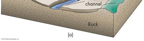
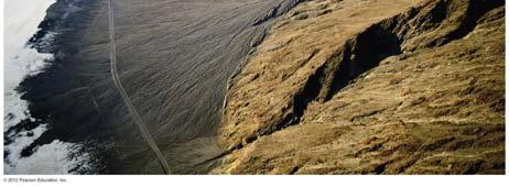
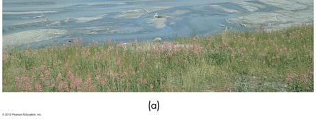
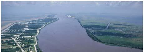
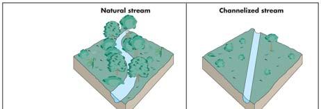
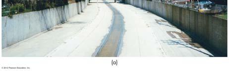
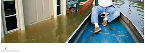
1 Introduction to Environmental Geology, 5e Running Water: summary in haiku form Edward A. Keller Chapter 9 Rivers and Flooding Lecture Presentation prepared by X. Mara Chen, Salisbury University The hydro cycle water returns from the sea. All "toilet to tap." Case History: Pakistan Floods of 2010 Water covers about 70 percent of Earth s surface, and flood causes a significant hazard to human life and property The number of people killed or affected, along with economic loss, is the greatest in Asia A monsoon refers to a seasonal shift in air pressure and precipitation patterns (dry winter to wet summer) August of 2010, the greatestmonsoon rains in decades, caused catastrophic flooding in Pakistan Killed about 1,600 people, and 20 million people were affected Case History: Implications The population of Pakistan has grown from about 34 million in 1951 to 170 million in 2010 Most people in Pakistan live close to the river About 20 percent of Pakistan was flooded in 2010 We need to rethink our philosophy of how we adjust to the flood hazard in the United States as population continues to grow We need plans for future flood hazard reduction that do not require massive evacuation from flood prone areas Avoid the hazard through land use instead of massive evacuation Case History Rivers: Historical Use For more than 200 years, Americans have lived and worked on floodplains, depending on soil, water supply, ease of waste disposal, and the commerce If the floodplain and its relation to the river are not recognized, flood control and drainage of wetlands become prime concerns The pioneers moved west modifying the land: cutting and burning the trees, and then modifying the natural drainage Figure 9.2a 1

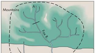
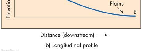
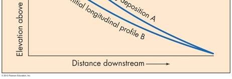
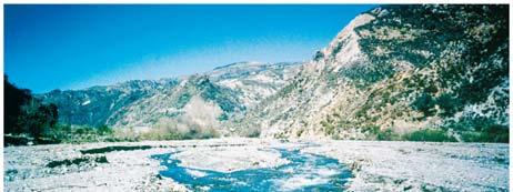
2 Streams and Rivers Streams and Rivers Part of the hydrologic cycle Streams: Small rivers River components Network of streams Watershed or drainage basin Base level and slope/gradient Latitudinal profile Longitudinal profile Grading processes Figure 9.5a Sediment in Rivers (1) Stream total load: Total amount of sediments Bed load: Coarse particles moving along the bottom of river channel, less than 10 percent of the total load Suspended load: Accounts for about 90 percent of its total load and makes river look muddy Sediment in Rivers (2) Stream competence and capacity Competence: Measuring the maximum size of the sediments transported by a river Capacity: Total amount of sediments a river is capable of transporting Dissolved load: Carried in chemical solutions, such as HCO 3-, SO 4 2-, Ca +, Na +, Mg + River Dynamic Characteristics (1) Continuity equation: Discharge: The volume of water passing through a given location of a river per unit of time Q = W *D *V Gradient: Vertical drop over horizontal flowing distance, expressed in percentage, ft/mi, or degree of the slope Stream velocity: Largely depending on stream gradient, discharge, channel shape, and turbulence River Erosion (1) Erosion types Abrasion by sediments transported by river Hydraulic action of moving water Chemical corrosion Erosion location Downcutting Lateral: Concentrating on the outer bends 2
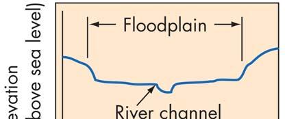
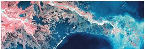
3 River Erosion Effectiveness Stream velocity Stream discharge Stream load Nature of the rocks Regional topographic relief Base level Climatic conditions River Sediment Deposition (1) Deposition Condition: The flow of a river slows down Decrease of stream gradient Decrease of velocity Decrease of discharge Change of channel shape Change in the amount of stream load (e.g., land-use change, vegetation cover) Change of geologic setting (e.g., rock types along the river banks) River Sediment Deposition (2) Deposition features Floodplain Natural levee Point bar Island bar Alluvial fan Delta River Erosion and Deposition Ever-changing processes: Time and rate of erosion and deposition Reasons for the changes Complex, but related to Changes in river channel (width, depth, and slope) Composition of channel bed and banks Vegetation cover Variations of weather and climate pattern Human activities, particularly land-use changes Effects of Land-Use Changes (1) Changes in infiltration rate: Change of the amount of water flowing into a river Soil erosion: Change in the amount of sediments in a river Amount of water and sediments in river: Changes in the velocity of water flow Changes in river s velocity: Leading the change in river dynamics Effects of Land-Use Changes (2) Forest to farmland Increases soil erosion, stream deposition Increases gradient and velocity Increases river-channel erosion Urban build-up Increases impervious cover Increases lower-magnitude flood frequency Reduces the lag time of flood 3

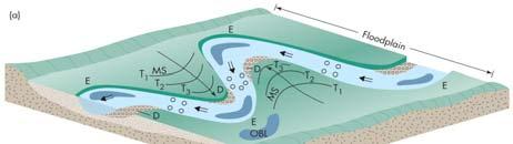
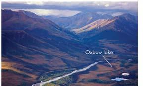
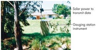
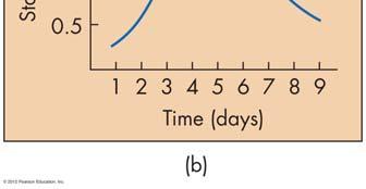
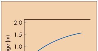
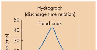
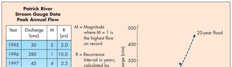
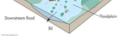
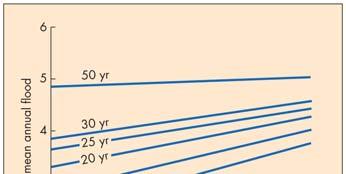
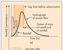
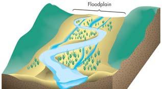
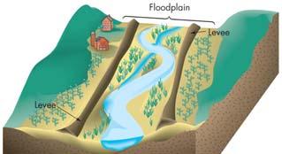
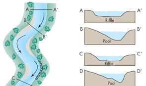
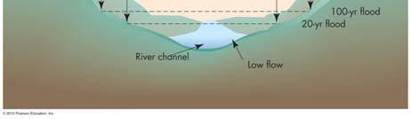
4 Channel Patterns and Floodplain Formation Braided: If the river s longitudinal profile is steep and there is an abundance of coarse bed load sediment Braided channels tend to be wide and shallow compared with meandering rivers Associated with steep rivers being rapidly uplifted by tectonic processes or rivers receiving water from melting glaciers Meanders migrate laterally by erosion on the cut banks and by deposition on point bars Meandering channels often contain a series of regularly spaced pools and riffles River Flooding Flooding: Overbank flow condition, discharge greater than channel s holding capacity Stage: The height of the water level in a river at a given location at a given time Hydrograph: Graphic representation of a river s discharge over time Lag time: The amount of time between the occurrence of peak rainfall and the onset of flooding Flooding Data Measurement Frequency and Magnitude of Flood Figure 9.D Recurrence interval R = (N + 1)/M N as the number of years of record, M is the rank of individual flow within the recorded years The probability of a given magnitude flood P = 1/R Statistical probability versus reality Probability: One 25-year flood, on average, once every 25 years Reality: Two 25-year floods can occur in two consecutive years Types of Flooding Factors Affecting Flood Damage By stream location Upstream flood: Shorter duration, smaller area Downstream flood: Longer duration, greater magnitude, larger area By duration Flash flood: High volume of flooding water in very short duration, characteristic short lag time, usually in upstream Non-flash flood By magnitude/recurrence interval 100-year, 50-year, 25-year, 10-year floods Regional land-use changes, such as urban development, deforestation, soil erosion, etc. Land use on the floodplain Frequency and magnitude of flooding Lag time and duration of flooding Sediment load Effectiveness of forecasting, warning, and emergency management 4


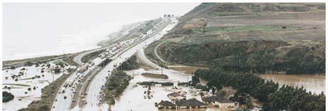
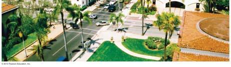
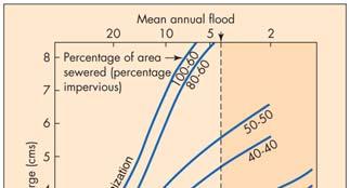
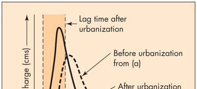
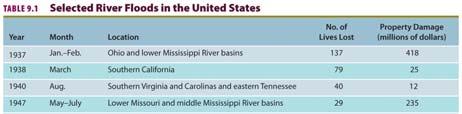
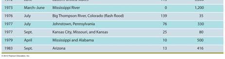
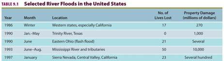
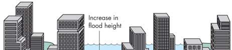
5 Urbanization and Flooding Urbanization and Flooding Impact on frequency and magnitude Increase in both frequency and magnitude, especially in small drainage basins Impact on a river s discharge Increase in runoff, without an increase in precipitation Significant reduction in lag time or flashy discharge Figure 9.20 Urbanization and Flooding Nature and Extent of Flood Hazard Factors affecting the flood damage Type of land use on the floodplain Magnitude and frequency of flood Rate and duration of flood Season of the flood Population density Public awareness Effectiveness of forecasting, warning, and emergency planning Figure 9.22b Selected Floods in the United States Selected Floods in the United States Table 9.1a Table 9.1b 5
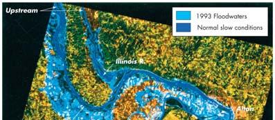
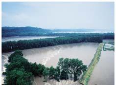
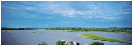
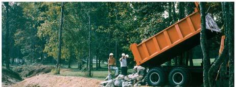
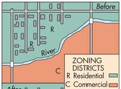
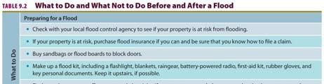
6 Selected Floods in the United States Effects of Flooding Table 9.1c Primary effects Injury and loss of life, damage and destruction of property, erosion and deposition of sediments Secondary effects Water pollution Fire Diseases Displacement of people Interruption of social and economic activities Adjustments to Flood Hazards (1) The structural approach Physical/Engineering barriers: Levee augmentation (see next slide) Channelization River-channel restoration Flood insurance: Shared responsibility and accountability Flood-proofing: Raised foundation, floodwalls, waterproof doors and windows, pumps Closer Look: Mississippi Flood Two major recent floods, 1973 and spring flood Evacuation of tens of thousands Inundation of thousands km 2 of farmland $1.2 billion in property damage 1993 summer flood Century flood in magnitude From climatic anomaly, unusual precipitation and snowmelt Lasted from late June to early August 50 deaths, $10 billion in damage Levees can provide a false sense of security Adjustments to Flood Hazards (2) Floodplain regulation: Obtaining the most beneficial use of floodplains Flood-hazard mapping Floodplain zoning Government buyout and relocating people from floodplain Personal adjustments Perception of Flooding Individual level: Variable in their knowledge of flooding, anticipation of future flooding, and willingness to accept adjustments Local and state t level: l Mitigation plans Federal government level Mapping of flood-prone areas Floodplain management plans Public outreach 6


7 Critical Thinking Topics Chapter 9 Images Follow: As a planner, outline a plan of action working for a community that is expanding into the headwater portions of drainage basins. What is the largest floods ever occurred in your area? With the global warming, what do you think the frequency and magnitude of flooding would change? Differentiate between competency and capacity. Does a stream s competency and capacity change over time? 7
8 8
9 9
10 10
11 11
12 12

13 13

14 14
15 15
16 16
17 17
18 18
19 19
20 End of Chapter Edward A. Keller Lecture Presentation prepared by X. Mara Chen, Salisbury University 20
Environmental Geology Chapter 9 Rivers and Flooding
 Environmental Geology Chapter 9 Rivers and Flooding Flooding in Pakistan 2010-1600 killed/20000 affected The hydrologic cycle is powered by the Sun The cycle includes evaporation, precipitation, infiltration,
Streams. Stream Water Flow
 CHAPTER 14 OUTLINE Streams: Transport to the Oceans Does not contain complete lecture notes. To be used to help organize lecture notes and home/test studies. Streams Streams are the major geological agents
Running Water Earth - Chapter 16 Stan Hatfield Southwestern Illinois College
 Running Water Earth - Chapter 16 Stan Hatfield Southwestern Illinois College Hydrologic Cycle The hydrologic cycle is a summary of the circulation of Earth s water supply. Processes involved in the hydrologic
GEOL 1121 Earth Processes and Environments
 GEOL 1121 Earth Processes and Environments Wondwosen Seyoum Department of Geology University of Georgia e-mail: seyoum@uga.edu G/G Bldg., Rm. No. 122 Seyoum, 2015 Chapter 6 Streams and Flooding Seyoum,
Fresh Water: Streams, Lakes Groundwater & Wetlands
 Fresh Water:, Lakes Groundwater & Wetlands Oct 27 Glaciers and Ice Ages Chp 13 Nov 3 Deserts and Wind and EXAM #3 Slope hydrologic cycle P = precip I = precip intercepted by veg ET = evapotranspiration
STREAM SYSTEMS and FLOODS
 STREAM SYSTEMS and FLOODS The Hydrologic Cycle Precipitation Evaporation Infiltration Runoff Transpiration Earth s Water and the Hydrologic Cycle The Hydrologic Cycle The Hydrologic Cycle Oceans not filling
Precipitation Evaporation Infiltration Earth s Water and the Hydrologic Cycle. Runoff Transpiration
 STREAM SYSTEMS and FLOODS The Hydrologic Cycle Precipitation Evaporation Infiltration Earth s Water and the Hydrologic Cycle Runoff Transpiration The Hydrologic Cycle The Hydrologic Cycle Oceans not filling
What do you need for a Marathon?
 What do you need for a Marathon? Water and a snack? What about just a normal day? 1 flush = 3.5 gallons 1 flush = 3.5 gallons 10 minute shower = 20 gal 1 flush = 3.5 gallons 10 minute shower = 20 gal Jeans
ES 105 Surface Processes I. Hydrologic cycle A. Distribution % in oceans 2. >3% surface water a. +99% surface water in glaciers b.
 ES 105 Surface Processes I. Hydrologic cycle A. Distribution 1. +97% in oceans 2. >3% surface water a. +99% surface water in glaciers b. >1/3% liquid, fresh water in streams and lakes~1/10,000 of water
Floods Lecture #21 20
 Floods 20 Lecture #21 What Is a Flood? Def: high discharge event along a river! Due to heavy rain or snow-melt During a flood, a river:! Erodes channel o Deeper & wider! Overflows channel o Deposits sediment
WATER ON AND UNDER GROUND. Objectives. The Hydrologic Cycle
 WATER ON AND UNDER GROUND Objectives Define and describe the hydrologic cycle. Identify the basic characteristics of streams. Define drainage basin. Describe how floods occur and what factors may make
Summary. Streams and Drainage Systems
 Streams and Drainage Systems Summary Streams are part of the hydrologic cycle and the chief means by which water returns from the land to the sea. They help shape the Earth s surface and transport sediment
Landscape Development
 Landscape Development Slopes Dominate Natural Landscapes Created by the interplay of tectonic and igneous activity and gradation Deformation and uplift Volcanic activity Agents of gradation Mass wasting
Final Exam. Running Water Erosion and Deposition. Willamette Discharge. Running Water
 Final Exam Running Water Erosion and Deposition Earth Science Chapter 5 Pages 120-135 Scheduled for 8 AM, March 21, 2006 Bring A scantron form A calculator Your 3 x 5 paper card of formulas Review questions
Streams. Water. Hydrologic Cycle. Geol 104: Streams
 Streams Why study streams? Running water is the most important geologic agent in erosion, transportation and deposition of sediments. Water The unique physical and chemical properties of water make it
Surface Water and Stream Development
 Surface Water and Stream Development Surface Water The moment a raindrop falls to earth it begins its return to the sea. Once water reaches Earth s surface it may evaporate back into the atmosphere, soak
UGRC 144 Science and Technology in Our Lives/Geohazards
 UGRC 144 Science and Technology in Our Lives/Geohazards Flood and Flood Hazards Dr. Patrick Asamoah Sakyi Department of Earth Science, UG, Legon College of Education School of Continuing and Distance Education
Erosion Surface Water. moving, transporting, and depositing sediment.
 + Erosion Surface Water moving, transporting, and depositing sediment. + Surface Water 2 Water from rainfall can hit Earth s surface and do a number of things: Slowly soak into the ground: Infiltration
How Do Human Impacts and Geomorphological Responses Vary with Spatial Scale in the Streams and Rivers of the Illinois Basin?
 How Do Human Impacts and Geomorphological Responses Vary with Spatial Scale in the Streams and Rivers of the Illinois Basin? Bruce Rhoads Department of Geography University of Illinois at Urbana-Champaign
River Response. Sediment Water Wood. Confinement. Bank material. Channel morphology. Valley slope. Riparian vegetation.
 River Response River Response Sediment Water Wood Confinement Valley slope Channel morphology Bank material Flow obstructions Riparian vegetation climate catchment vegetation hydrological regime channel
11/12/2014. Running Water. Introduction. Water on Earth. The Hydrologic Cycle. Fluid Flow
 Introduction Mercury, Venus, Earth and Mars share a similar history, but Earth is the only terrestrial planet with abundant water! Mercury is too small and hot Venus has a runaway green house effect so
The Hydrologic Cycle STREAM SYSTEMS. Earth s Water and the Hydrologic Cycle. The Hydrologic Cycle. Hydrologic Cycle
 STREAM SYSTEMS Earth Science: Chapter 5 Reading pages 114-124 The Hydrologic Cycle Oceans not filling up Evaporation = precipitation System is balanced Earth s Water and the Hydrologic Cycle Earth s Water
Stream Geomorphology. Leslie A. Morrissey UVM July 25, 2012
 Stream Geomorphology Leslie A. Morrissey UVM July 25, 2012 What Functions do Healthy Streams Provide? Flood mitigation Water supply Water quality Sediment storage and transport Habitat Recreation Transportation
Aquifer an underground zone or layer of sand, gravel, or porous rock that is saturated with water.
 Aggradation raising of the streambed by deposition that occurs when the energy of the water flowing through a stream reach is insufficient to transport sediment conveyed from upstream. Alluvium a general
Science of Natural Disasters: RIVERS& FLOODS! 27 April 2016
 Science of Natural Disasters: RIVERS& FLOODS! 27 April 2016 Rebecca Clotts Department of Geology, University of St Thomas Flood in St Paul, 2014, Star Tribune 1 2 What is a watershed? 3 4 5 6 7 What is
Figure 1. Which part of the river is labelled in Figure 1? a) Mouth b) Source c) Lower course d) channel
 Mouth b) Source c) Lower course d) channel") Rivers 1. Study Figure 1 showing the long profile of a river Figure 1 A Which part of the river is labelled in Figure 1? a) Mouth b) Source c) Lower course d) channel (1 mark) 2. Complete the sentences
Rivers 1. Study Figure 1 showing the long profile of a river Figure 1 A Which part of the river is labelled in Figure 1? a) Mouth b) Source c) Lower course d) channel (1 mark) 2. Complete the sentences
Earth Science Chapter 6 Section 2 Review
 Name: Class: Date: Earth Science Chapter 6 Section Review Multiple Choice Identify the choice that best completes the statement or answers the question. 1. Most streams carry the largest part of their
In the space provided, write the letter of the description that best matches the term or phrase. a. any form of water that falls to Earth s
 Skills Worksheet Concept Review In the space provided, write the letter of the description that best matches the term or phrase. 1. condensation 2. floodplain 3. watershed 4. tributary 5. evapotranspiration
Flooding. April 21, Notes 4/20 CONGRATULATIONS!!!!! Activity 2: AZ State Museum due TODAY. Extra Credit 2: Returned at end of class
 April 21, 2011 Flooding 1927 Mississippi Flood Notes 4/20 Activity 2: AZ State Museum due TODAY Extra Credit 2: Returned at end of class CONGRATULATIONS!!!!! Andrew Richard Undergraduate Research Grant
Section 5. Low-Gradient Streams. What Do You See? Think About It. Investigate. Learning Outcomes
 Chapter 4 Surface Processes Section 5 Low-Gradient Streams What Do You See? Learning Outcomes In this section, you will Use models and real-time streamflow data to understand the characteristics of lowgradient
STUDY GUIDE FOR CONTENT MASTERY. Surface Water Movement
 Surface Water SECTION 9.1 Surface Water Movement In your textbook, read about surface water and the way in which it moves sediment. Complete each statement. 1. An excessive amount of water flowing downslope
mountain rivers fixed channel boundaries (bedrock banks and bed) high transport capacity low storage input output
 high transport capacity low storage input output") mountain rivers fixed channel boundaries (bedrock banks and bed) high transport capacity low storage input output strong interaction between streams & hillslopes Sediment Budgets for Mountain Rivers Little
mountain rivers fixed channel boundaries (bedrock banks and bed) high transport capacity low storage input output strong interaction between streams & hillslopes Sediment Budgets for Mountain Rivers Little
Rivers and Streams. Streams. Hydrologic Cycle. Drainage Basins and Divides. Colorado River Drainage Basin. Colorado Drainage Basins.
 Chapter 14 Hydrologic Cycle Rivers and Streams Streams A stream is a body of water that is confined in a channel and moves downhill under the influence of gravity. This definition includes all sizes of
Which map shows the stream drainage pattern that most likely formed on the surface of this volcano? A) B)
 B)") 1. When snow cover on the land melts, the water will most likely become surface runoff if the land surface is A) frozen B) porous C) grass covered D) unconsolidated gravel Base your answers to questions
1. When snow cover on the land melts, the water will most likely become surface runoff if the land surface is A) frozen B) porous C) grass covered D) unconsolidated gravel Base your answers to questions
Rivers and Landslides
 Rivers and Landslides Path of desire or path of least resistance? Desire Path: A term in landscape architecture used to describe a path that isn t designed but rather is worn casually away by people finding
Conceptual Model of Stream Flow Processes for the Russian River Watershed. Chris Farrar
 Conceptual Model of Stream Flow Processes for the Russian River Watershed Chris Farrar Several features of creeks affect the interactions between surface and groundwater. This conceptual model uses the
Surface Water Short Study Guide
 Name: Class: Date: Surface Water Short Study Guide Multiple Choice Identify the letter of the choice that best completes the statement or answers the question. 1. The three ways in which a stream carries
Surface Processes Focus on Mass Wasting (Chapter 10)
") Surface Processes Focus on Mass Wasting (Chapter 10) 1. What is the distinction between weathering, mass wasting, and erosion? 2. What is the controlling force in mass wasting? What force provides resistance?
Surface Processes Focus on Mass Wasting (Chapter 10) 1. What is the distinction between weathering, mass wasting, and erosion? 2. What is the controlling force in mass wasting? What force provides resistance?
Mountain Rivers. Gutta cavat lapidem. (Dripping water hollows out a stone) -Ovid, Epistulae Ex Ponto, Book 3, no. 10, 1. 5
 -Ovid, Epistulae Ex Ponto, Book 3, no. 10, 1. 5") Mountain Rivers Gutta cavat lapidem (Dripping water hollows out a stone) -Ovid, Epistulae Ex Ponto, Book 3, no. 10, 1. 5 Mountain Rivers Fixed channel boundaries (bedrock banks and bed) High transport
Mountain Rivers Gutta cavat lapidem (Dripping water hollows out a stone) -Ovid, Epistulae Ex Ponto, Book 3, no. 10, 1. 5 Mountain Rivers Fixed channel boundaries (bedrock banks and bed) High transport
Lecture Outlines PowerPoint. Chapter 5 Earth Science 11e Tarbuck/Lutgens
 Lecture Outlines PowerPoint Chapter 5 Earth Science 11e Tarbuck/Lutgens 2006 Pearson Prentice Hall This work is protected by United States copyright laws and is provided solely for the use of instructors
Laboratory Exercise #3 The Hydrologic Cycle and Running Water Processes
 Laboratory Exercise #3 The Hydrologic Cycle and Running Water Processes page - 1 Section A - The Hydrologic Cycle Figure 1 illustrates the hydrologic cycle which quantifies how water is cycled throughout
Catastrophic Events Impact on Ecosystems
 Catastrophic Events Impact on Ecosystems Hurricanes Hurricanes An intense, rotating oceanic weather system with sustained winds of at least 74 mph and a welldefined eye Conditions for formation: Warm water
River/Stream Erosion Notes
 Name Date ES per Mr. Williams River/Stream Erosion Notes Erosion: the of weathered material. FACT: Running water moves more sediment than ANY other type of erosion. 1. The Water Cycle What happens when
Weathering, Erosion, Deposition, and Landscape Development
 Weathering, Erosion, Deposition, and Landscape Development I. Weathering - the breakdown of rocks into smaller particles, also called sediments, by natural processes. Weathering is further divided into
Chapter 10. Running Water aka Rivers. BFRB Pages
 Chapter 10 Running Water aka Rivers BFRB Pages 101-116 Stream Erosion and Transportation Running water is all precipitation (rain, snow, etc) that falls on Earth and is pulled downhill by gravity. Running
Running Water: The Geology of Streams and Floods Running Water Chapter 14
 Geology 800 Today Running Water: The Geology of Streams and Floods Running Water Chapter 14 Next Class Oceans and Coasts 15 Stream Flow Streams Ribbons of water that flow down channels. Runoff Water in
FLUVIAL PROCESSES 13 MARCH 2014
 FLUVIAL PROCESSES 13 MARCH 2014 In this lesson we: Lesson Description Look at river profiles, river grading, river rejuvenation as well as the identification, description and formation of fluvial landforms.
6.1 Water. The Water Cycle
 6.1 Water The Water Cycle Water constantly moves among the oceans, the atmosphere, the solid Earth, and the biosphere. This unending circulation of Earth s water supply is the water cycle. The Water Cycle
Stream Restoration and Environmental River Mechanics. Objectives. Pierre Y. Julien. 1. Peligre Dam in Haiti (deforestation)
") Stream Restoration and Environmental River Mechanics Pierre Y. Julien Malaysia 2004 Objectives Brief overview of environmental river mechanics and stream restoration: 1. Typical problems in environmental
Stream Restoration and Environmental River Mechanics Pierre Y. Julien Malaysia 2004 Objectives Brief overview of environmental river mechanics and stream restoration: 1. Typical problems in environmental
RIVERS, GROUNDWATER, AND GLACIERS
 RIVERS, GROUNDWATER, AND GLACIERS Delta A fan-shaped deposit that forms when a river flows into a quiet or large body of water, such as a lake, an ocean, or an inland sea. Alluvial Fan A sloping triangle
Fluvial Systems Lab Environmental Geology Lab Dr. Johnson
 Fluvial Systems Lab Environmental Geology Lab Dr. Johnson *Introductory sections of this lab were adapted from Pidwirny, M. (2006). "Streamflow and Fluvial Processes". Fundamentals of Physical Geography,
ADDRESSING GEOMORPHIC AND HYDRAULIC CONTROLS IN OFF-CHANNEL HABITAT DESIGN
 ADDRESSING GEOMORPHIC AND HYDRAULIC CONTROLS IN OFF-CHANNEL HABITAT DESIGN Conor Shea - Hydrologist U.S. Fish and Wildlife Service Conservation Partnerships Program Arcata, CA Learning Objectives Examine
Why Geomorphology for Fish Passage
 Channel Morphology - Stream Crossing Interactions An Overview Michael Love Michael Love & Associates mlove@h2odesigns.com (707) 476-8938 Why Geomorphology for Fish Passage 1. Understand the Scale of the
Chapter 11. Rivers: Shaping our landscape
 Chapter 11 Rivers: Shaping our landscape Learning outcomes In this presentation you will learn: Common terms associated with rivers About the three stages of a river About the processes of river erosion
SPECIFIC DEGRADATION AND RESERVOIR SEDIMENTATION. By Renee Vandermause & Chun-Yao Yang
 SPECIFIC DEGRADATION AND RESERVOIR SEDIMENTATION By Renee Vandermause & Chun-Yao Yang Outline Sediment Degradation - Erosion vs Sediment Yield - Sediment Yield - Methods for estimation - Defining Sediment
What is weathering and how does it change Earth s surface? Answer the question using
 7 th Grade Lesson What is weathering and how does it change Earth s surface? Answer the question using the sentence frame. You have 4 minutes. Weathering is. This changes the Earth s surface because. 1
Term Knowledge Using and applying Grade Criteria Autumn 1 Assessment window October Natural hazards pose major risks to people and property.
 Assessment Schedule Year 9 2015/6 Term Knowledge Using and applying Grade Criteria Autumn 1 Assessment window October 2015 3.1.1.2 Tectonic Natural hazards pose major risks to people and property. Definition
APPENDIX E. GEOMORPHOLOGICAL MONTORING REPORT Prepared by Steve Vrooman, Keystone Restoration Ecology September 2013
 APPENDIX E GEOMORPHOLOGICAL MONTORING REPORT Prepared by Steve Vrooman, Keystone Restoration Ecology September 2 Introduction Keystone Restoration Ecology (KRE) conducted geomorphological monitoring in
PHYSICAL GEOGRAPHY. By Brett Lucas
 PHYSICAL GEOGRAPHY By Brett Lucas FLUVIAL PROCESSES Fluvial Processes The Impact of Fluvial Processes on the Landscape Streams and Stream Systems Stream Channels Structural Relationships The Shaping and
27. Running Water I (p ; )
") 27. Running Water I (p. 424-436; 440-444) Hydrosphere How much of the Earth s surface is covered by water? Earth's water is collectively called the and is stored in a number of so-called as follows: 1.
27. Running Water I (p. 424-436; 440-444) Hydrosphere How much of the Earth s surface is covered by water? Earth's water is collectively called the and is stored in a number of so-called as follows: 1.
THE RECURRENCE INTERVAL
 Floods GEOG 366 THE RECURRENCE INTERVAL How often can a storm of a given magnitude be expected to recur? Calculate as follows: Take list of annual peak flows (largest flow each year) and rank them. R.I.
Physical landscapes River landscapes in the UK
 Physical landscapes River landscapes in the UK The shape of river valleys change s as rivers flow downstream - PROCESSES Erosion Abrasion or corrasion Attrition Hydraulic Action Solution or corrosion Deposition
Appendix E Guidance for Shallow Flooding Analyses and Mapping
 Appendix E Guidance for Shallow Flooding Analyses and Mapping E.1 Introduction Different types of shallow flooding commonly occur throughout the United States. Types of flows that result in shallow flooding
Prentice Hall EARTH SCIENCE
 Prentice Hall EARTH SCIENCE Tarbuck Lutgens Running Water and Groundwater Running Water The Water Cycle Water constantly moves among the oceans, the atmosphere, the solid Earth, and the biosphere. This
Learning Objectives: I can identify and interpret river flows and directions.
 Learning Objectives: I can identify and interpret river flows and directions. Bellringer Review: Check for Understanding Questions: 1 2 What Are The Key Parts Of A River s Anatomy? In your data notebooks
GY 111 Lecture Note Series Sedimentary Environments 2: Rivers and Deltas
 GY 111 Lecture Notes D. Haywick (2008-09) 1 GY 111 Lecture Note Series Sedimentary Environments 2: Rivers and Deltas Lecture Goals A) Rivers and Deltas (types) B) Water Flow and sedimentation in river/deltas
Rivers T. Perron
 1 Rivers T. Perron 12.001 After our discussions of large-scale topography, how we represent topography in maps, and how topography interacts with geologic structures, you should be frothing at the mouth
Working with Natural Stream Systems
 Working with Natural Stream Systems Graydon Dutcher Delaware County Soil & Water Conservation District Stream Corridor Management Program Tropical Storm Sandy October 29,2012 What is a Watershed?
High-Gradient Streams
 Chapter 4 Surface Processes Section 4 High-Gradient Streams What Do You See? Learning Outcomes In this section, you will Use models and real-time streamflow data to understand the characteristics of highgradient
ENGINEERING HYDROLOGY
 ENGINEERING HYDROLOGY Prof. Rajesh Bhagat Asst. Professor Civil Engineering Department Yeshwantrao Chavan College Of Engineering Nagpur B. E. (Civil Engg.) M. Tech. (Enviro. Engg.) GCOE, Amravati VNIT,
Consequences of river regulation works: altered fluvial processes + increasing flood hazard
 Consequences of river regulation works: altered fluvial processes + increasing flood hazard Dr. Tímea Kiss assistant professor Department of Physical Geography and Geoinformatics, University of Szeged,
Continuing Education Associated with Maintaining CPESC and CESSWI Certification
 Continuing Education Associated with Maintaining CPESC and CESSWI Certification Module 2: Stormwater Management Principles for Earth Disturbing Activities Sponsors: ODOTs Local Technical Assistance Program
Miami-Dade College. The student will demonstrate a basic knowledge of the origin and evolution of the Earth and its planetary environment.
 Miami-Dade College Common Course Number: GLY 3884 Course Title: Environmental Geology Catalog Course Description: This course focuses on the study of the application of geology to the interactions between
Watershed concepts for community environmental planning
 Purpose and Objectives Watershed concepts for community environmental planning Dale Bruns, Wilkes University USDA Rural GIS Consortium May 2007 Provide background on basic concepts in watershed, stream,
APPROACH TO THE SPANISH WATER ORGANISATION IMPROVING FLOOD HAZARD MAPPING, LAWS AND AUTHORITIES COORDINATION
 "Workshop On Land Use Planning And Water Management, With Focus On Flood Risk Management Oslo, Norway. Wednesday 31 January and Thursday 1 February 2007 APPROACH TO THE SPANISH WATER ORGANISATION IMPROVING
Upper Truckee River Restoration Lake Tahoe, California Presented by Brendan Belby Sacramento, California
 Upper Truckee River Restoration Lake Tahoe, California Presented by Brendan Belby Sacramento, California Mike Rudd (Project Manager), Charley Miller & Chad Krofta Declines in Tahoe s Water Clarity The
Riparian Assessment. Steps in the right direction... Drainage Basin/Watershed: Start by Thinking Big. Riparian Assessment vs.
 Riparian Assessment vs. Monitoring Riparian Assessment What is a healthy stream? Determine stream/riparian health Determine change or trend, especially in response to mgmt Classification = designation
SLOPE PROCESSES, LANDSLIDES, AND SUBSIDENCE
 CHAPTER 9 SLOPE PROCESSES, LANDSLIDES, AND SUBSIDENCE La Conchita slide January 10, 2005 Triggered by heavy rainfall, reactivation along an older landslide surface (35,000 years ago, 6000 years ago, and
Gateway Trail Project
 Gateway Trail Project Debris Flow Hazard Assessment By: Juan de la Fuente April 30, 2010 Background- On April 22, 2010, the Shasta-Trinity National Forest (Mt. Shasta-McCloud Unit) requested a geologic
Earth Science Chapter 9. Day 6 - Finish Capillary Action Lab - Quiz over Notes - Review Worksheets over Sections 9.2 and 9.3
 Earth Science Chapter 9 Day 1 Day 2 Day 3 Read Section 9.1 Surface Water Chapter 9 Term Sheet Notes over Section 9.1 Surface Water Section 9.1 Review Worksheets Quiz over Section 9.1 Notes Virtual Lab
Year 6. Geography. Revision
 Year 6 Geography Revision November 2017 Rivers and World knowledge How the water cycle works and the meaning of the terms evaporation, condensation, precipitation, transpiration, surface run-off, groundwater
EROSION AND DEPOSITION
 CHAPTER 8 EROSION AND DEPOSITION SECTION 8 1 Changing Earth s Surface (pages 252-255) This section explains how sediment is carried away and deposited elsewhere to wear down and build up Earth s surface.
River Restoration and Rehabilitation. Pierre Y. Julien
 River Restoration and Rehabilitation Pierre Y. Julien Department of Civil and Environmental Engineering Colorado State University Fort Collins, Colorado River Mechanics and Sediment Transport Lima Peru
National Hydrology committee of Afghanistan (NHCA) Sedimentation in Reservoire
 Sedimentation in Reservoire") National Hydrology committee of Afghanistan (NHCA) Sedimentation in Reservoire OCt.2007 Prof. Mohammad Qasem Seddeqy KPU بسم االله الرحمن الرحيم وجعلنامن الماءکل شي ء حی 30 واز ا ب هر چيزی رازنده گردانيدیم
National Hydrology committee of Afghanistan (NHCA) Sedimentation in Reservoire OCt.2007 Prof. Mohammad Qasem Seddeqy KPU بسم االله الرحمن الرحيم وجعلنامن الماءکل شي ء حی 30 واز ا ب هر چيزی رازنده گردانيدیم
 12 10 8 6 4 2 0 40-50 50-60 60-70 70-80 80-90 90-100 Fresh Water What we will cover The Hydrologic Cycle River systems Floods Groundwater Caves and Karst Topography Hot springs Distribution of water in
Pequabuck River Flooding Study and Flood Mitigation Plan The City of Bristol and Towns of Plainville and Plymouth, CT
 Pequabuck River Flooding Study and Flood Mitigation Plan The City of Bristol and Towns of Plainville and Plymouth, CT Raymond Rogozinski and Maged Aboelata The City of Bristol and Towns of Plainville and
River floodplain regime and stratigraphy. Drs. Nanette C. Kingma.
 River floodplain regime and stratigraphy. Drs. Nanette C. Kingma. Formation of floodplain. Formation of floodplains: lateral channel migration in channel deposition suspended-load fall out during higher
Science EOG Review: Landforms
 Mathematician Science EOG Review: Landforms Vocabulary Definition Term canyon deep, large, V- shaped valley formed by a river over millions of years of erosion; sometimes called gorges (example: Linville
NATURE OF RIVERS B-1. Channel Function... ALLUVIAL FEATURES. ... to successfully carry sediment and water from the watershed. ...dissipate energy.
 1 2 Function... Sevier River... to successfully carry sediment and water from the watershed....dissipate energy. 3 ALLUVIAL FEATURES 4 CHANNEL DIMENSION The purpose of a stream is to carry water and sediment
Queensland Floods- Part A
 Queensland Floods- Part A Floods Flooding is when the water level in a creek, river, lake or the sea rises and covers land that is normally dry. The rise in water can be due to numerous causes, although
Do you think sediment transport is a concern?
 STREAM RESTORATION FRAMEWORK AND SEDIMENT TRANSPORT BASICS Pete Klingeman 1 What is Your Restoration Project Like? k? Do you think sediment transport is a concern? East Fork Lewis River, WA Tidal creek,
Monitoring Headwater Streams for Landscape Response to
 Monitoring Headwater Streams for Landscape Response to Climate Change Matthew Connor, PhD Connor nvironmental, nc. www.oe-i.com icom Healdsburg, California verview Headwater stream geomorphology Response
GLG362/GLG598 Geomorphology K. Whipple October, 2009 I. Characteristics of Alluvial Channels
 I. Characteristics of Alluvial Channels Self-formed morphology set by entrainment, transport, and deposition They move unconsolidated sedimentary materials present in the valley fill flood plain/bank flow
Overview of a Changing Climate in Rhode Island
 Overview of a Changing Climate in Rhode Island David Vallee, Hydrologist in Charge, National Weather Service Northeast River Forecast Center, NOAA Lenny Giuliano, Air Quality Specialist, Rhode Island Department
Environmental Geology
 F O U R T H E D I T I O N Introduction to Environmental Geology Edward A. Keller University of California, Santa Barbara PEARSON Prentice Hall Pearson Education International CONTENTS Preface xiii PART
Sediment Deposition LET THE RIVER RUN T E A C H E R. Activity Overview. Activity at a Glance. Time Required. Level of Complexity.
 Activity at a Glance Grade: 6 9 Subject: Science Category: Physical Science, Earth Science Topic: Deposition, River Systems Time Required Two 45-minute periods Level of Complexity Medium Materials* TI-73
1/20/2013. Introduction to Environmental Geology, 5e. Case History: Island of Hispaniola. Earth History. Earth s Place in Space
 Introduction to Environmental Geology, 5e Edward A. Keller Chapter 1 Philosophy and Fundamental Concepts Intro to Geology: summary haiku Here's geology. It's the study of the Earth - complete entity. Lecture
SCOPE OF PRESENTATION STREAM DYNAMICS, CHANNEL RESTORATION PLANS, & SEDIMENT TRANSPORT ANALYSES IN RELATION TO RESTORATION PLANS
 DESIGN METHODS B: SEDIMENT TRANSPORT PROCESSES FOR STREAM RESTORATION DESIGN PETER KLINGEMAN OREGON STATE UNIVERSITY CIVIL ENGINEERING DEPT., CORVALLIS 2 ND ANNUAL NORTHWEST STREAM RESTORATION DESIGN SYMPOSIUM
Climate also has a large influence on how local ecosystems have evolved and how we interact with them.
 The Mississippi River in a Changing Climate By Paul Lehman, P.Eng., General Manager Mississippi Valley Conservation (This article originally appeared in the Mississippi Lakes Association s 212 Mississippi
New GCSE Geography AQA
 Learning Checklist Half Term 1 26 th September 3 rd October 10 th October 17 th October 1.1.1 Tectonic Hazards Plate tectonics theory. Global distribution of earthquakes and volcanic eruptions and their