National Wetlands Inventory Update for New England 2009
|
|
|
- Egbert May
- 5 years ago
- Views:
Transcription
1 National Wetlands Inventory Update for New England 2009 Ralph Tiner Wetland Ecologist U.S. Fish & Wildlife Service National Wetlands Inventory Program
2 Where we ve been Maps Status and trends investigations Where we are going to some degree New mapping approach More specific classification New products Wetland digital data Challenge ahead
3 Where We ve Been
4
 CTDEP support Summary reports Massachusetts")
5 State Reports Rhode Island (1989) EPA support Connecticut (1991) CTDEP support Summary reports Massachusetts Vermont
6 Other Reports Various local wetlands status and trends reports (covering 1970s-80s) published before 1999 Central Connecticut Southeastern Massachusetts Casco Bay, ME Cobscook Bay, ME Plum Island to Scituate, MA Neponset Watershed, MA
7 WHERE WE ARE GOING Wetland Mapping Updated and Improved mapping Expanded wetland classification
8 Improved Wetland Mapping Better imagery Larger scale (1:40,000 vs 1:58,000/1:80,000) CIR preferred Digital imagery (e.g., 1-m or 1-ft resolution) Collateral data readily available in digital form Soils data Hydro (stream) data State wetland inventory data Better base maps (DOQQs) GIS technology = operational
9 Wetland Mapping Procedures On-screen photointerpretation Adding undeveloped hydric soil map units (H_wetland type, HPFO ) where there seems to be a good correlation between the units and wetlands on the ground Base Map = DOQQ (1:12K) PRODUCT will likely show more areas of wetlands and potential wetlands
10
11
12
13
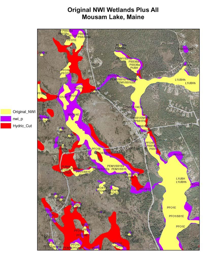
14 Change in Wetland Acreage - Example Original NWI = 414 acres New NWI (photointerpreted only) = 523 acres (+109 acres or 26% increase) New NWI + Undev. Hydric Soils = 718 acres (+195 acres; 37% increase over PIed wetlands; 73% increase over original NWI) Undeveloped Hydric Soils coded as: H-NWI type, such as HPFO1B, HPSS1B
15 New NWI Mapping Technique Should identify More wetland acreage (variable) Smaller wetlands (incl. ponds) Areas with high potential for containing wetlands (undeveloped hydric soil map units) Separates photointerpretable wetlands from those we cannot see, but can be interpreted from the soils data 1:12K (DOQQ) base map image
16 Limitations of New NWI Method Can readily do where digital soils data are available Hydric soil wetlands may contain variable amounts of wetland (variable quality of soil surveys) still best available. Don t view imagery in stereo


17 Recent Updates New England Coastal Maine Western half of Vermont Southern Vermont Eastern Massachusetts Rhode Island
18 Updates More recent imagery More detail More drier-end wetlands Smaller wetlands Better stream information Integration of hydric soils data Standard NWI classification Some projects enhanced classification LLWW descriptors Future Updates: Plan to add LLWW descriptors
19 Where We Can Go Landscape-level Wetland Assessment Preliminary assessments of wetland functions for large geographic areas Other Possibilities: Potential Wetland Restoration Sites Watershed condition re: natural habitat Summary Reports Basic Inventory Findings Watershed Assessments Wetland Functions
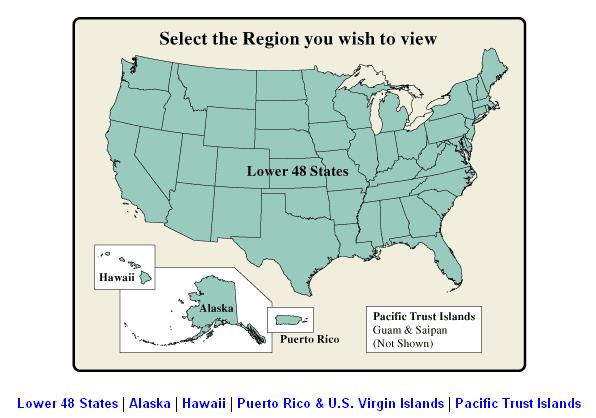
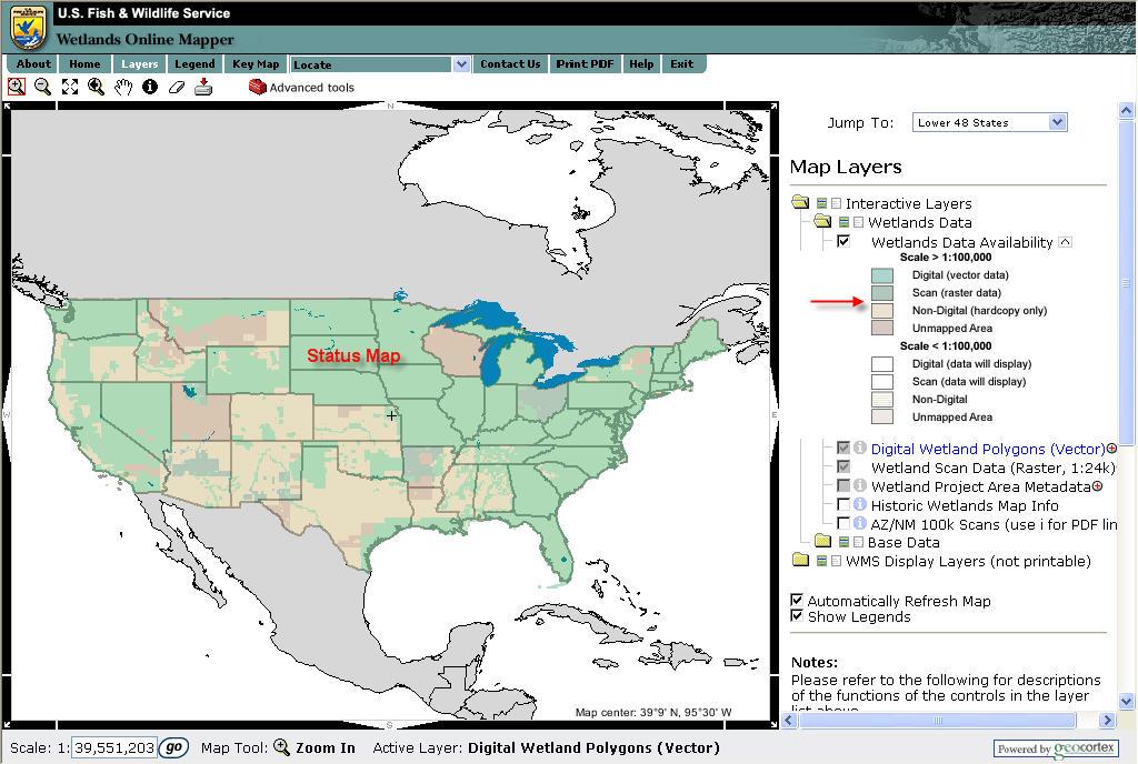
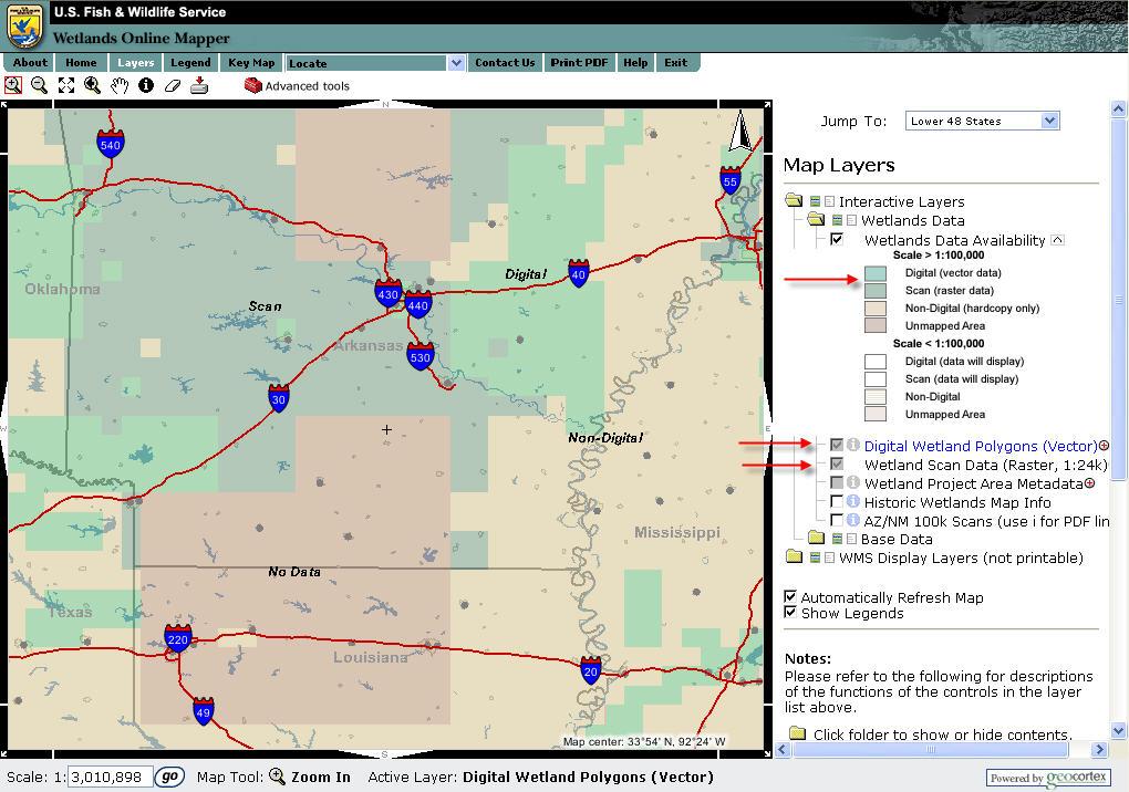
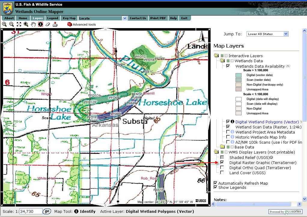
20 Reports since 1999 Casco Bay watershed wetland characterization and functional assessment (1999) Wetlands of Boston Harbor Islands (2003) Coastal wetland trends Parker River Estuary (2002) Narragansett Bay Estuary (2004) Boston Harbor, Cape Cod & the Islands (2006) Selected small estuaries in CT (2006) Eelgrass surveys (Eastern LI Sound; 2003, 2006) Potential wetland restoration site inventories For MA Wetland Restoration Program (w/umass)
21 2007 Reports NWI Summary Reports
22 Pending Reports Wetlands of Cape Cod and the Islands, Massachusetts: Current Status and Landscape-level Functional Assessment Summary of Wetlands NWI Types LLWW Types Predicted Wetland Functions Narrative and Maps Cape Cod/vicinity, Martha s Vineyard, Nantucket, and the Elizabeth Islands
23 NWI Types
24 Wetlands by Landscape Position
25 Wetlands by Water Flow Path
26 Nutrient Retention
27 Rhode Island New State Report Planned Same as for Cape Cod NWI Wetlands, LLWW Wetlands Wetland Functions Narrative and Maps Need final QC on LLWW and data analysis Working on funding
28 NWI Data Availability Not making paper maps Data available online: Online mapping tool Wetlands Mapper Custom maps Download digital data For GIS applications

29 Wetland Mapper 3.5 million hits/month
30
31
32
33
34
35
36
37

38 Wetlands Metadata
39 Historic Wetland Map Info

40 Historic Wetland Map Info
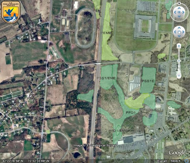
41 Wetlands on Google Earth Go to NWI website Click on View NWI w/google Earth Click on WetlandsData.KMZ and this program will automatically load on Google Earth Then type in the area of interest, and away you go.

42 NWI on Google Earth Status Map page
43


44 NWI on The National Map
45 Future Activity of NWI in New England Long Island Sound Eelgrass Mapping Funded by EPA Summer 2009 Cooperating with Massachusetts on their wetland conservancy mapping Plan to Add to National Database Beyond this =???? Unknown Due to funding issues Program focus on another national wetland trends analysis over next two years
46 The Challenge Need to get NWI focus back on mapping (digital data generation) since data are outdated for many areas
Use of Remote Sensing and GIS for Wetland, Riparian, and Watershed Assessment, Restoration, and Monitoring
 Use of Remote Sensing and GIS for Wetland, Riparian, and Watershed Assessment, Restoration, and Monitoring Ralph Tiner Wetland Ecologist U.S. Fish & Wildlife Service National Wetlands Inventory Program
Wetlands and Riparian Mapping Framework Technical Meeting
 Wetlands and Riparian Mapping Framework Technical Meeting Meghan Burns Landscape Ecologist Linda Vance Senior Ecologist Why wetland and riparian mapping? Preliminary site assessment for the presence of
Wetland Mapping & Functional Assessment Canadian River Watershed New Mexico. Association of State Wetland Managers
 Wetland Mapping & Functional Assessment Canadian River Watershed New Mexico Association of State Wetland Managers November, 2012 Approach for this project based on: EPA 2006 Document: Application of Elements
The Evolution of NWI Mapping and How It Has Changed Since Inception
 The Evolution of NWI Mapping and How It Has Changed Since Inception Some Basic NWI Facts: Established in 1974 Goal to create database on characteristics and extent of U.S. wetlands Maps & Statistics In
Water Atlas Overview. Myakka River Management Coordinating Council June 22, 2012 Englewood, Florida
 Water Atlas Overview Myakka River Management Coordinating Council June 22, 2012 Englewood, Florida What is the Water Atlas? A data warehouse A set of interactive maps A collection of tools for viewing/analyzing
Wetland and Riparian Mapping: An Overview of the Montana Program
 Wetland and Riparian Mapping: An Overview of the Montana Program Meghan Burns, Catherine McIntyre, Karen Newlon Ecology Program Montana Natural Heritage Program Helena, MT Montana Natural Heritage Program
Developing Soil Maps and Interpretations for Shallow Subtidal Habitats
 Developing Soil Maps and Interpretations for Shallow Subtidal Habitats James D. Turenne Assistant State Soil Scientist Rhode Island (The Ocean State) USDA-NRCS Narragansett Bay Estuary LNB Coastal Lagoons
Wetland Mapping. Wetland Mapping in the United States. State Wetland Losses 53% in Lower US. Matthew J. Gray University of Tennessee
 Wetland Mapping Caribbean Matthew J. Gray University of Tennessee Wetland Mapping in the United States Shaw and Fredine (1956) National Wetlands Inventory U.S. Fish and Wildlife Service is the principle
Improvement of the National Hydrography Dataset for Parts of the Lower Colorado Region and Additional Areas of Importance to the DLCC
 Improvement of the National Hydrography Dataset for Parts of the Lower Colorado Region and Additional Areas of Importance to the DLCC Carlos Reyes-Andrade California State University, Northridge September
Retrospective Governance Analysis for the Narragansett Bay Watershed and Airshed Project
 Retrospective Governance Analysis for the Narragansett Bay Watershed and Airshed Project An Example of How To Conduct A Governance Analysis in a New or Expanded Area Prepared for: Environmental Protection
NCSS Soil Survey Updates & Intro to Coastal Zone and Subaqueous Soil Data
 NCSS Soil Survey Updates & Intro to Coastal Zone and Subaqueous Soil Data Jim Turenne, CPSS Assistant State Soil Scientist RI USDA NRCS http://nesoil.com/sas and www.mapcoast.org Digital Soils Data CT,
Home About Us Articles Press Releases Image Gallery Contact Us Media Kit Free Subscription 10/5/2006 5:56:35 PM
 Home About Us Articles Press Releases Image Gallery Contact Us Media Kit Free Subscription 10/5/2006 5:56:35 PM Industry Resources Industry Directory NASA Links Missions/Launches Calendar Human development
Current and Future Technology Applications for Coastal Zone Management. Bruce K. Carlisle, Acting Director Office of Coastal Zone Management
 Current and Future Technology Applications for Coastal Zone Management Bruce K. Carlisle, Acting Director Office of Coastal Zone Management The Massachusetts Coastal Zone Management Program Approved in
Fig 1. Steps in the EcoValue Project
 Assessing the Social and Economic Value of Ecosystem Services in the Northern Forest Region: A Geographic Information System (GIS) Approach to Landscape Valuation Principal Investigator(s): Dr. Matthew
GIS Data and Technology to Support Transportation & MPO Decision-Making & Planning. using an Eco-Logical* Approach within the Kansas City Region
 GIS Data and Technology to Support Transportation & MPO Decision-Making & Planning using an Eco-Logical* Approach within the Kansas City Region Authors (in alphabetical order): Tom Gerend, Tom Jacobs,
Shoreline Mapping & Erosion Patterns. Julia Knisel Julia Knisel Coastal Shoreline & Floodplain Manager
 Shoreline Mapping & Erosion Patterns Along the Massachusetts Coast Julia Knisel Julia Knisel Coastal Shoreline & Floodplain Manager CZM Shoreline Change Project Timeline 1989: produced coast wide maps
1) make sure folks know what s available in terms of geospatial data and resources that could contribute to their decision support toolkits;
 make sure folks know what s available in terms of geospatial data and resources that could contribute to their decision support toolkits;") Introduction 1 2001 It was born out of the recognition that several of the regions prominent resource management agencies have similar, if not shared, requirements for GIS data. Some of the underlying
Introduction 1 2001 It was born out of the recognition that several of the regions prominent resource management agencies have similar, if not shared, requirements for GIS data. Some of the underlying
What is a watershed or landscape perspective?
 What is a watershed or landscape perspective? -remove sediment -add sediment -add wood, riparian manipulation -alter (engineer) channel/floodplain morphology -restore/abandon roads You are here What is
Digital Wetlands. Bringing the Field into the Office Through GIS
 Digital Wetlands Bringing the Field into the Office Through GIS Maryland Department of the Environment Wetlands and Waterways Program MDE's Wetlands and Waterways Program seeks to conserve valuable aquatic
The Refugia Concept: Using Watershed Analysis to Prioritize Salmonid Habitat for Conservation and Restoration
 The Refugia Concept: Using Watershed Analysis to Prioritize Salmonid Habitat for Conservation and Restoration Christopher May Battelle & UW Cumulative Impacts of Urbanization Landscape Alterations Loss
Assessing state-wide biodiversity in the Florida Gap analysis project
 University of Nebraska - Lincoln DigitalCommons@University of Nebraska - Lincoln Nebraska Cooperative Fish & Wildlife Research Unit -- Staff Publications Nebraska Cooperative Fish & Wildlife Research Unit
A Help Guide for Using gssurgo to Find Potential Wetland Soil Landscapes
 A Help Guide for Using gssurgo to Find Potential Wetland Soil Landscapes Wetland Mapping Consortium Webinar September 17, 2014 Dr. John M. Galbraith Crop & Soil Environmental Sciences Virginia Tech Wetland
Modeling Sea-Level Rise in Coastal Wetlands: Understanding Potential Impacts and Their Implications for Management on Cape Cod
 Modeling Sea-Level Rise in Coastal Wetlands: Understanding Potential Impacts and Their Implications for Management on Cape Cod C a p e C o a s t a l C o n f e r e n c e H y a n n i s R e s o r t a n d
Summary Description Municipality of Anchorage. Anchorage Coastal Resource Atlas Project
 Summary Description Municipality of Anchorage Anchorage Coastal Resource Atlas Project By: Thede Tobish, MOA Planner; and Charlie Barnwell, MOA GIS Manager Introduction Local governments often struggle
GIS Data, Technology, and Models. to Integrate Information and Improve Transportation Decision-Making. within the Eco-Logical* Framework for Oregon
 GIS Data, Technology, and Models to Integrate Information and Improve Transportation Decision-Making within the Eco-Logical* Framework for Oregon GIS-T 2009, Oklahoma City, OK April 8, 2009, Session 5..2.2
A Comprehensive Inventory of the Number of Modified Stream Channels in the State of Minnesota. Data, Information and Knowledge Management.
 A Comprehensive Inventory of the Number of Modified Stream Channels in the State of Minnesota Data, Information and Knowledge Management Glenn Skuta Environmental Analysis and Outcomes Division Minnesota
Preliminary Results from Coordinated Sea-Level Rise Modeling Using SLAMM, the Sea Level Affecting Marshes Model, Across the US Gulf of Mexico Coast
 Preliminary Results from Coordinated Sea-Level Rise Modeling Using SLAMM, the Sea Level Affecting Marshes Model, Across the US Gulf of Mexico Coast James W. Pahl, Ph.D., and Kristin DeMarco, State of Louisiana
Create your own map for tidepooling, beach field trips, boating, camping, kayaking, fishing, and exploring the beaches in Southcentral Alaska.
 Create your own map for tidepooling, beach field trips, boating, camping, kayaking, fishing, and exploring the beaches in Southcentral Alaska. Here s an opportunity to download and customize your own free
Coastal Riparian Buffers Analysis
 Final Report To the EPA Office of Long Island Sound 1. Title Coastal Riparian Buffers Analysis EPA Grant Number: LI 97128801-0 2. Grantee Organization and Contact Name: Emily Wilson, Geospatial Research
Current Water Conditions in Massachusetts January 11, 2008
 Current Water Conditions in Massachusetts January 11, 2008 December precipitation was above normal December streamflows were below normal and normal December ground-water levels were below normal and normal
NAVAJO NATION PROFILE
 NAVAJO NATION PROFILE Largest land based area and federally recognized tribe in the United States Over 27,000 square miles (or 17.2 million acres with a population of over 300,000 people. Covers Arizona,
NOAA s OCM: Services, tools and collaboration opportunities & Puerto Rico s NE Marine Corridor as a case study
 NOAA s OCM: Services, tools and collaboration opportunities & Puerto Rico s NE Marine Corridor as a case study Dr. Antares Ramos Álvarez NOAA s Office of Coastal Management September 15 th, 2016 Conservation
The Use of Geographic Information Systems to Assess Change in Salt Marsh Ecosystems Under Rising Sea Level Scenarios.
 The Use of Geographic Information Systems to Assess Change in Salt Marsh Ecosystems Under Rising Sea Level Scenarios Robert Hancock The ecological challenges presented by global climate change are vast,
A wetland is not fully protected til it s safely in a geo-database MassDEP 1 Winter Street Boston, MA
 Massachusetts Wetlands Mapping and Monitoring Program A wetland is not fully protected til it s safely in a geo-database Massachusetts Long History of Wetlands Protection Regulations Densely developed
ESRI NONPROFIT/CONSERVATION GRANTS PROGRAM STATUS REPORT JANUARY 2010
 ESRI NONPROFIT/CONSERVATION GRANTS PROGRAM STATUS REPORT JANUARY 2010 Grantee ESRI Client Number 150983 FARMINGTON RIVER WATERSHED ASSOCIATION 749 Hopmeadow Street, Simsbury, Connecticut 06070 Contact:
 www.ct.gov/opm/cdplan Role of the Locational Guide Map State agencies shall not provide funding for certain growth-related projects unless such projects are located within a priority funding area LGM shall
EBA Engineering Consultants Ltd. Creating and Delivering Better Solutions
 EBA Engineering Consultants Ltd. Creating and Delivering Better Solutions ENHANCING THE CAPABILITY OF ECOSYSTEM MAPPING TO SUPPORT ADAPTIVE FOREST MANAGEMENT Prepared by: EBA ENGINEERING CONSULTANTS LTD.
Overview. Project Background Project Approach: Content and Application Development Application Demonstration Future Developments
 Overview Project Background Project Approach: Content and Application Development Application Demonstration Future Developments Southeast Pressures: Continued Population Growth Transportation Corridors
Native species (Forbes and Graminoids) Less than 5% woody plant species. Inclusions of vernal pools. High plant diversity
 Less than 5% woody plant species. Inclusions of vernal pools. High plant diversity") WILLAMETTE VALLEY WET-PRAIRIE RESTORATION MODEL WHAT IS A WILLAMETTE VALLEY WET-PRAIRIE Hot Spot s Native species (Forbes and Graminoids) Rare plant species Less than 5% woody plant species Often dominated
WILLAMETTE VALLEY WET-PRAIRIE RESTORATION MODEL WHAT IS A WILLAMETTE VALLEY WET-PRAIRIE Hot Spot s Native species (Forbes and Graminoids) Rare plant species Less than 5% woody plant species Often dominated
APPROVED JURISDICTIONAL DETERMINATION FORM U.S. Army Corps of Engineers
 APPROVED JURISDICTIONAL DETERMINATION FORM U.S. Army Corps of Engineers This form should be completed by following the instructions provided in Section IV of the JD Form Instructional Guidebook. SECTION
Tier Mapping of Zostera marina in Long Island Sound and Change Analysis
 Tier 1 2017 Mapping of Zostera marina in Long Island Sound and Change Analysis By Michael Bradley University of Rhode Island Environmental Data Center mike@edc.uri.edu and Suzanne Paton Southern New England
Southern California Coastal Water Research Project. Sharon De Leon. California State University Northridge. June 19, May 2013
 Southern California Coastal Water Research Project Sharon De Leon California State University Northridge June 19, 2012- May 2013 Shawna Dark, Center of Geographical Studies, California State University
UPDATING THE MINNESOTA NATIONAL WETLAND INVENTORY
 UPDATING THE MINNESOTA NATIONAL WETLAND INVENTORY An Integrated Approach Using Object-Oriented Image Analysis, Human Air-Photo Interpretation and Machine Learning AARON SMITH EQUINOX ANALYTICS INC. FUNDING
GEOG 487 Lesson 3: Step-by-Step Activity
 GEOG 487 Lesson 3: Step-by-Step Activity Part I: Explore Publically Available Wetlands Data & Historical Imagery In Part I, we will explore our study area and the time-series aerial photos used to digitize
Lecture 3. Data Sources for GIS in Water Resources
 Lecture 3 Data Sources for GIS in Water Resources GIS in Water Resources Spring 2015 http://www.data.gov/ 1 USGS GIS data for Water http://water.usgs.gov/maps.html Watersheds of the US 2-digit water resource
HURRICANE IRENE. CONFERENCE CALL BRIEFING SLIDES Saturday August 27, :30 AM
 HURRICANE IRENE CONFERENCE CALL BRIEFING SLIDES Saturday August 27, 2011 8:30 AM NHC TRACK AND CONE HURRICANE IRENE WATCHES/WARNINGS Hurricane Warning along south coast including all of Cape Cod and Islands
Storm Summary for Hurricane Jose
 Storm Summary for Hurricane Jose Tuesday, September 19, 2017 at 11 AM EDT (Output from Hurrevac, based on National Hurricane Center Forecast Advisory #57) Jose is currently a Category 1 hurricane on the
Wetland & Floodplain Functional Assessments and Mapping To Protect and Restore Riverine Systems in Vermont. Mike Kline and Laura Lapierre Vermont DEC
 Wetland & Floodplain Functional Assessments and Mapping To Protect and Restore Riverine Systems in Vermont Mike Kline and Laura Lapierre Vermont DEC NWI+ Hydro-Geomorphic Characterization of Wetlands and
Development of Webbased. Tool for Tennessee
 Development of Webbased Farm Mapping Tool for Tennessee Southern Region Water Quality Conference, Oct. 24 2005 Forbes Walker and Alan Jolly Biosystems Engineering and SOIL SCIENCE Nutrient Management Planning
1.1 What is Site Fingerprinting?
 Site Fingerprinting Utilizing GIS/GPS Technology 1.1 What is Site Fingerprinting? Site fingerprinting is a planning tool used to design communities where protection of natural resources is the primary
Coastal Response Research Center. Nancy Kinner University of New Hampshire (UNH) Michele Jacobi NOAA ORR. September 27, 2007
 Michele Jacobi NOAA ORR. September 27, 2007") Coastal Response Research Center Nancy Kinner University of New Hampshire (UNH) Michele Jacobi NOAA ORR September 27, 2007 1 Coastal Response Research Center (CRRC) CRRC is partnership between NOAA s Office
Coastal Response Research Center Nancy Kinner University of New Hampshire (UNH) Michele Jacobi NOAA ORR September 27, 2007 1 Coastal Response Research Center (CRRC) CRRC is partnership between NOAA s Office
Chapter 3 - White Oak River Subbasin Includes Bogue Sound and the Newport River
 Chapter 3 - White Oak River Subbasin 03-05-03 Includes Bogue Sound and the Newport River 3.1 Water Quality Overview Subbasin 03-05-03 at a Glance Land and Water Area (sq. mi.) Total area: 228 Land area:
Roger Andy Gaines, Research Civil Engineer, PhD, P.E.
 Roger Andy Gaines, Research Civil Engineer, PhD, P.E. Research Civil Engineer/Regional Technical Specialist Memphis District August 24, 2010 Objectives Where we have been (recap of situation and what s
1) NetMap Overview. 2) Habitat modeling HIP & Beyond. 3) What do you do with habitat models? 4) NetMap a platform for regional analysis & interactions
 NetMap Overview. 2) Habitat modeling HIP & Beyond. 3) What do you do with habitat models? 4) NetMap a platform for regional analysis & interactions") 1) NetMap Overview 2) Habitat modeling HIP & Beyond 3) What do you do with habitat models? 4) NetMap a platform for regional analysis & interactions Overview Multiple analysis tools Creates universal stream/hillslope
1) NetMap Overview 2) Habitat modeling HIP & Beyond 3) What do you do with habitat models? 4) NetMap a platform for regional analysis & interactions Overview Multiple analysis tools Creates universal stream/hillslope
SoilView: Development of a Custom GIS Application for Publishing Soil Surveys
 SoilView: Development of a Custom GIS Application for Publishing Soil Surveys Allan Johnson and Mike Wigginton Abstract Currently, digital soils information can be obtained from many sources. Numerous
Sea Level Rise Providing Nature A-Right-of Way
 Sea Level Rise Providing Nature A-Right-of Way Study Area Site 2: Skagit Bay Initial Condition 11.2 Inches by 2050 No Dikes 27.3 Inches by 2100 No Dikes The Problem Loss of coastal wetlands due to submergence
Image segmentation for wetlands inventory: data considerations and concepts
 Image segmentation for wetlands inventory: data considerations and concepts Intermountain West Joint Venture Presented by : Patrick Donnelly Spatial Ecologist Intermountain West Joint Venture Missoula,
An Internet-based Agricultural Land Use Trends Visualization System (AgLuT)
") An Internet-based Agricultural Land Use Trends Visualization System (AgLuT) Prepared for Missouri Department of Natural Resources Missouri Department of Conservation 07-01-2000-12-31-2001 Submitted by
An Internet-based Agricultural Land Use Trends Visualization System (AgLuT) Prepared for Missouri Department of Natural Resources Missouri Department of Conservation 07-01-2000-12-31-2001 Submitted by
Overview of Methods. Terrestrial areas that are most important for conservation Conservation
 Overview of Methods The goal of the Western Lake Erie Coastal Conservation Vision project (WLECCV) is to define where we should be working locally to optimally achieve regional conservation impact. The
United States Department of the Interior NATIONAL PARK SERVICE Northeast Region
 United States Department of the Interior NATIONAL PARK SERVICE Northeast Region June 17, 2017 REQUEST FOR STATEMENTS OF INTEREST and QUALIFICATIONS Project Title: ASSESSMENT OF NATURAL RESOURCE CONDITION
MAPPING AND ANALYSIS OF FRAGMENTATION IN SOUTHEASTERN NEW HAMPSHIRE
 MAPPING AND ANALYSIS OF FRAGMENTATION IN SOUTHEASTERN NEW HAMPSHIRE Meghan Graham MacLean, PhD Student Dr. Russell G. Congalton, Professor Department of Natural Resources & the Environment, University
Community Mapping Network. Selected Coastal Atlases and Information Systems in British Columbia, Canada
 Community Mapping Network Selected Coastal Atlases and Information Systems in British Columbia, Canada Outline Community Mapping Network cmnbc.ca Pacific Coastal Resources Atlas for BC cmnbc.ca The Living
Restoring Rivers in Cumbria Online Story Map of a case study on the River Lyvennet
 Restoring Rivers in Cumbria Online Story Map of a case study on the River Lyvennet Summary This Story Map presents a river restoration case study for the River Eden Catchment, Cumbria. Students can learn
New Land Cover & Land Use Data for the Chesapeake Bay Watershed
 New Land Cover & Land Use Data for the Chesapeake Bay Watershed Why? The Chesapeake Bay Program (CBP) partnership is in the process of improving and refining the Phase 6 suite of models used to inform
EnviroAtlas: An Atlas about Ecosystems and their Connection with People
 EnviroAtlas: An Atlas about Ecosystems and their Connection with People Annie Neale, Megan Mehaffey & Atlas Team ASWM Webinar October, 17 th, 2012 What is it? The Atlas is an online decision support tool
APPROVED JURISDICTIONAL DETERMINATION FORM U.S. Army Corps of Engineers
 APPROVED JURISDICTIONAL DETERMINATION FORM U.S. Army Corps of Engineers This form should be completed by following the instructions provided in Section IV of the JD Form Instructional Guidebook. SECTION
Chesapeake Bay Remote Sensing Pilot Executive Briefing
 Chesapeake Bay Remote Sensing Pilot Executive Briefing Introduction In his Executive Order 13506 in May 2009, President Obama stated The Chesapeake Bay is a national treasure constituting the largest estuary
SAGE. Systems Approach to Geomorphic Engineering. Barnegat Bay Pilot. Heather Jensen Philadelphia District. US Army Corps of Engineers BUILDING STRONG
 SAGE Systems Approach to Geomorphic Engineering Barnegat Bay Pilot Heather Jensen Philadelphia District US Army Corps of Engineers SAGE Nationwide program with a Regional Approach Innovative approach to
Introduction to Coastal GIS
 Introduction to Coastal GIS Event was held on Tues, 1/8/13 - Thurs, 1/10/13 Time: 9:00 am to 5:00 pm Location: Roger Williams University, Bristol, RI Audience: The intended audiences for this course are
Introduction: The Gulf of Mexico Alliance. The Gulf GAME project MERMAid and PHINS Results & Conclusions What s next? Examples
 AAG Las Vegas March 25, 2009 Introduction: Ocean governance and Ecosystem-Based Management The Gulf of Mexico Alliance Habitat Identification and Characterization The Gulf GAME project MERMAid and PHINS
CHAPTER 4: POPULATION
 State of Narragansett Bay and Its Watershed 2017 Technical Report Landscape Stressor Indicators CHAPTER 4: POPULATION Please use the following citation: Narragansett Bay Estuary Program. 2017. State of
Introduction to Geographic Information Systems
 Introduction to Geographic Information Systems What is GIS? GIScience, Geography and Cartography GIS Maps Why is it important? What is Driving GIS? Applications of GIS Case Studies Components of a GIS
Harrison 1. Identifying Wetlands by GIS Software Submitted July 30, ,470 words By Catherine Harrison University of Virginia
 Harrison 1 Identifying Wetlands by GIS Software Submitted July 30, 2015 4,470 words By Catherine Harrison University of Virginia cch2fy@virginia.edu Harrison 2 ABSTRACT The Virginia Department of Transportation
Ecological Land Cover Classification For a Natural Resources Inventory in the Kansas City Region, USA
 Ecological Land Cover Classification For a Natural Resources Inventory in the Kansas City Region, USA by Applied Ecological Services, Inc. In cooperation with the Mid-America Regional Council 600 Broadway,
Exercise 6: Coordinate Systems
 Exercise 6: Coordinate Systems This exercise will teach you the fundamentals of Coordinate Systems within QGIS. In this exercise you will learn: How to determine the coordinate system of a layer How the
USGS National Hydrography Dataset (NHD) and NHDPlus
 and NHDPlus") + 1 + USGS National Hydrography Dataset (NHD) and NHDPlus Al Rea USGS National Geospatial Program Western States Water Council August 1, 2018 + 2 USGS National Hydrography Datasets Hydrologic networks,
+ 1 + USGS National Hydrography Dataset (NHD) and NHDPlus Al Rea USGS National Geospatial Program Western States Water Council August 1, 2018 + 2 USGS National Hydrography Datasets Hydrologic networks,
VCCS Geospatial Institute 2011
 John McGee Jennifer McKee With support from: NSF DUE-0903270 Acquiring and Downloading Digital Data in partnership with: Geospatial Technician Education Through Virginia s Community Colleges (GTEVCC) Review
APPROVED JURISDICTIONAL DETERMINATION FORM U.S. Army Corps of Engineers
 APPROVED JURISDICTIONAL DETERMINATION FORM U.S. Army Corps of Engineers This form should be completed by following the instructions provided in Section IV of the JD Form Instructional Guidebook. SECTION
GIS and Coastal Nutrients Luke Cole
 GIS and Coastal Nutrients Luke Cole Human population density has been widely utilized as a valid predictor of terrestrial nitrogen loads into marine systems. As 50% of the world s population lives within
Human Impacts to Rivers
 Human Impacts to Rivers Sediment Water Wood Confinement Valley slope Channel morphology Bank material Flow obstructions Riparian vegetation Human Impacts on Rivers dams channelization loss of woody debris/riparian
Ecological Site Descriptions ESDs : NRCS Site-based Approach to Land Classification and Evaluation. Nels Barrett, NRCS Ecologist SSSSNE 20
 Ecological Site Descriptions ESDs : NRCS Site-based Approach to Land Classification and Evaluation Nels Barrett, NRCS Ecologist SSSSNE 20 Overview Definition of Ecological Sites, ES Content of Ecological
Baseline Estuarine-Upland Transition Zone
 Baseline Estuarine-Upland Transition Zone in SF, San Pablo and Suisun Bays 10/5/18 Prepared for San Francisco Bay Joint Venture (SFBJV) Prepared by Brian Fulfrost, Principal bfaconsult@gmail.com with additional
Virginia Shoreline Mapping Tools
 Virginia Shoreline Mapping Tools December 15, 2017 Karen Duhring Center for Coastal Resources Management Virginia Institute of Marine Science College of William & Mary Virginia Shoreline Mapping Tools
Geospatial Data, Services, and Products. National Surveying, mapping and geospatial conference
 Geospatial Data, Services, and Products Federal Programs -- USDA NRCS National Surveying, mapping and geospatial conference March 15, 2016 NRCS Applications using Geosaptial Products & Services Field
Identifying Trends in Exclusions and Feature Revisions to Promote Better Recon. Surface Water Status Monitoring Network
 Identifying Trends in Exclusions and Feature Revisions to Promote Better Recon Surface Water Status Monitoring Network Andy Woeber GIS Analyst Watershed Monitoring Section FDEP Tallahassee Surface water
COASTAL DATA APPLICATION
 2015 Coastal GeoTools Proactive By Design. Our Company Commitment COASTAL DATA APPLICATION Projecting Future Coastal Flood Risk for Massachusetts Bay Bin Wang, Tianyi Liu, Daniel Stapleton & Michael Mobile
Global reviews of wetland inventory, classification and delineation
 Max Finlayson Institute for Land, Water & Society Charles Sturt University Albury, Australia Global reviews of wetland inventory, classification and delineation Initiatives/meetings over two decades have
DUC 2017 Fieldwork Overview: Akaitcho Wetland Mapping Project
 DUC 2017 Fieldwork Overview: Akaitcho Wetland Mapping Project Prepared for MobileDemand Project Managers: Kevin Smith, Al Richard Lead Technical Analyst: *Michael Merchant Support Analysts: Becca Warren,
APPROVED JURISDICTIONAL DETERMINATION FORM U.S. Army Corps of Engineers
 APPROVED JURISDICTIONAL DETERMINATION FORM U.S. Army Corps of Engineers This form should be completed by following the instructions provided in Section IV of the JD Form Instructional Guidebook. SECTION
ICAN Great Lakes Workshop
 Washington Coastal latlas ICAN Great Lakes Workshop September 13 15, 15 2010 Current Washington Coastal Atlas http://www.ecy.wa.gov/programs/sea/sma/atlas_home.html 1 st version of WA Coastal Atlas was
Mulberry Island, Virginia Quadrangle, USGS 7.5 Minute Topo Map By USGS
 Mulberry Island, Virginia Quadrangle, USGS 7.5 Minute Topo Map By USGS If you are looking for a ebook Mulberry Island, Virginia Quadrangle, USGS 7.5 Minute Topo Map by USGS in pdf form, then you've come
Ocean Boundary Currents Guiding Question: How do western boundary currents influence climate and ocean productivity?
 Name: Date: TEACHER VERSION: Suggested Student Responses Included Ocean Boundary Currents Guiding Question: How do western boundary currents influence climate and ocean productivity? Introduction The circulation
12- TOL MLRA Soil Survey Area Approximately 15,000,000 Acres
 !@ 12- TOL MLRA Soil Survey Area Approximately 15,000,000 Acres Office Location: Tolland, Connecticut Staff: Donald Parizek Acting Soil Survey Office Party Leader Jacob Isleib Soil Scientist Marissa Theve
Environmental Response Management Application
 Environmental Response Management Application Coastal Response Research Center Nancy Kinner, Michele Jacobi, Rob Braswell, Kurt Schwehr & Amy Merten RRT III May 14, 2008 1 Talk Outline Overview of Center
Mapping and Modeling for Regional Planning
 Mapping and Modeling for Regional Planning Carol W. Witham Sacramento Valley Chapter California Native Plant Society contributors: David Ackerly John Dittes Julie Evens Josephine Guardino Robert F. Holland
Remote Sensing and Spatial Analysis (RSSA)
") MESM Track Remote Sensing and Spatial Analysis (RSSA) Dr. Y.Q. Wang (Track Chair) http://nrs.uri.edu/people/faculty/wang.html Remote Sensing and Spatial Analysis Remote sensing, GIS, GPS and their applications
MESM Track Remote Sensing and Spatial Analysis (RSSA) Dr. Y.Q. Wang (Track Chair) http://nrs.uri.edu/people/faculty/wang.html Remote Sensing and Spatial Analysis Remote sensing, GIS, GPS and their applications
Sea Turtle Sightings Per Unit Effort (Fall) Northwest Atlantic United States January 2010
 Northwest Atlantic United States January 2010") Sea Turtle Sightings Per Unit Effort (Fall) Northwest Atlantic United States January 2010 Prepared by: Eastern Division Conservation Science Office of The Nature Conservancy 99 Bedford Street, 5 th Floor
Sea Turtle Sightings Per Unit Effort (Fall) Northwest Atlantic United States January 2010 Prepared by: Eastern Division Conservation Science Office of The Nature Conservancy 99 Bedford Street, 5 th Floor
Sea Level Affecting Marshes Model (SLAMM) for Coastal Long Island Sound:
 for Coastal Long Island Sound:") 2100 DATA VIEWER MANUAL Sea Level Affecting Marshes Model (SLAMM) for Coastal Long Island Sound: Using a Web Mapping Application Data Viewer to Examine Predicted Land Cover Change for 2100 AUTHOR: KEVIN
2100 DATA VIEWER MANUAL Sea Level Affecting Marshes Model (SLAMM) for Coastal Long Island Sound: Using a Web Mapping Application Data Viewer to Examine Predicted Land Cover Change for 2100 AUTHOR: KEVIN
Presented by: Bryan Bloch GIS Specialist DNREC Division of Watershed Stewardship
 Presented by: Bryan Bloch GIS Specialist DNREC Division of Watershed Stewardship Bryan Hall, AICP Sussex County Circuit Rider Planner, Office of State Planning Coordination, OMB November 19, 2012 UD Sustainable
Leveraging LiDAR for Statewide NHD Hydrography Projects. Susan Phelps, CFM, GISP
 Leveraging LiDAR for Statewide NHD Hydrography Projects Susan Phelps, CFM, GISP Mon, July 11 th, 2016 National Hydrography Dataset (NHD) Background Why Local-Res NHD? Drivers Include: Availability of accurate