Modeling Sea-Level Rise in Coastal Wetlands: Understanding Potential Impacts and Their Implications for Management on Cape Cod
|
|
|
- Mitchell Fisher
- 5 years ago
- Views:
Transcription

1 Modeling Sea-Level Rise in Coastal Wetlands: Understanding Potential Impacts and Their Implications for Management on Cape Cod C a p e C o a s t a l C o n f e r e n c e H y a n n i s R e s o r t a n d C o n f e r e n c e C e n t e r D e c e m b e r 7, Photo credit: Mike McHugh, MassDEP Marc Carullo Massachusetts Office of Coastal Zone Management

2 Four scenarios with estimates of SLR by 2100 Rick Meyerowitz, From Forecast by Nicholas Blechman.
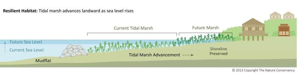
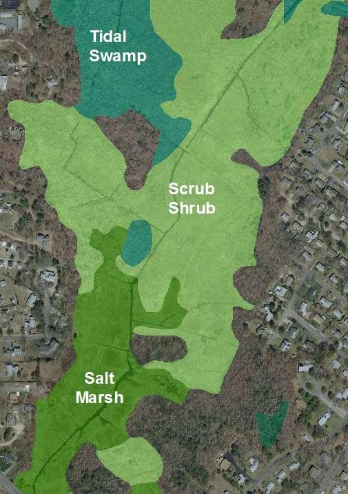
3 Project Objectives Understand potential for coastal wetland habitat conversion/loss under multiple scenarios of SLR Identify and assess opportunities for and barriers to marsh migration Engage stakeholders to better incorporate wetlands into adaptation strategies and planning efforts
4
5 Four scenarios with estimates of SLR by 2100 United States National Climate Assessment (Parris et al. 2012), adjusted for local subsidence Projected Scenario Lowest Intermediate Low Intermediate High Highest Total Sea Level Rise (Boston) m (0.82 feet) m (2.32 feet) m (4.54 feet) m (7.10 feet) Project Timescale M o d e l s u s e d : Sea-Level Affecting Marshes Model (SLAMM) Marsh Equilibrium Model (MEM)*
6
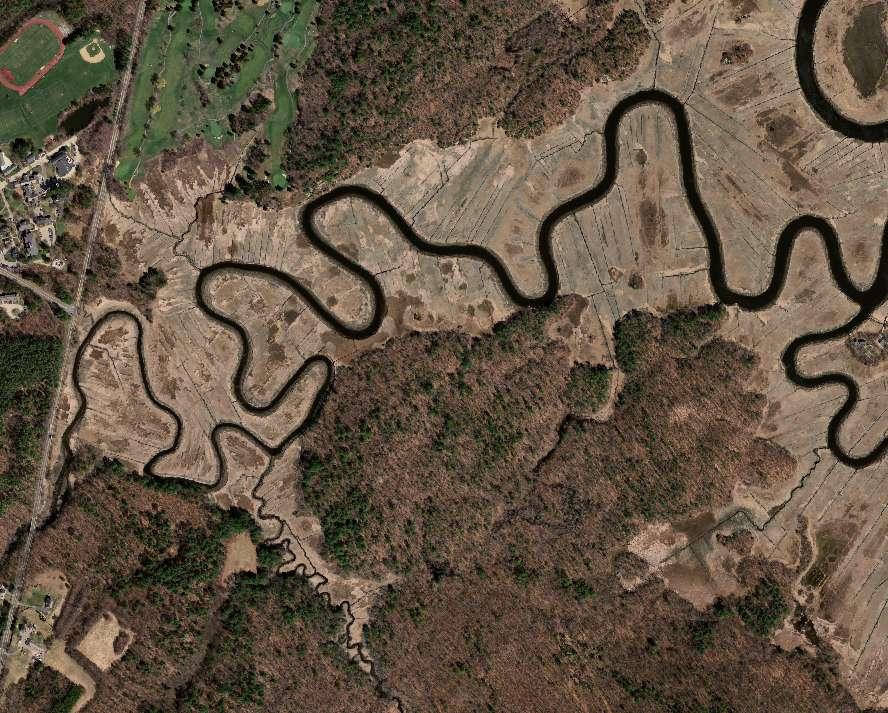
7 Cape Cod Cape Cod SLAMM Project Panels


8 Cape Cod Cape Cod SLAMM Project Panels
9 Annual Change in Area (Ha) Average annual change in area by decade* from for Cape Cod project panels Macrotidal areas* Microtidal areas* -150 Dry Land Open Ocean Estuarine Open Water Regularly- Flooded Marsh Irregularly-Fl ooded Marsh Transitional Marsh Time Period (Decade) for Select SLAMM Classes D R A F T
10 Potential Salt Marsh Trends from Cape Cod Intermediate High SLR Scenario > 3500 ha increase in reg-flooded marsh (low marsh zone), 225% > 5500 ha decrease in irreg-flooded marsh (high marsh zone), 87% Total loss of approximately 2000 ha of salt marsh, 25% Marshes draining to Vineyard and Nantucket Sounds are potentially more susceptible to loss from SLR than those draining to Cape Cod Bay (i.e., tidal range sensitivity). 100 Years of Estuarine Marsh Trends in Massachusetts (1893 to 1995)
 MA w/in Buffer 400 200 0 Low Int Low Int High High SLR Scenario D R A F T North River,")
11 Area (Hectares) Potential Upland Marsh Migration w/in 100 ft Buffer South Shore Intermediate High SLR Scenario Migration Area (MA) MA w/in Buffer Low Int Low Int High High SLR Scenario D R A F T North River, Marshfield
12 SLR Scenarios Upland Marsh Migration South Shore Land Use / Land Cover Distribution of Potential Migration Areas Low 103 Int Low Int High Total Area (ha) Forest Agricultural Golf Course Residential Other* High 772 D R A F T 0% 20% 40% 60% 80% 100%

13 2100 Marsh Migration Potential *For illustrative purposes only Lidar DEM 12 m 5m -2 m Marsh-Upland Border Westport River - East Buzzards Bay West DRAFT Intermediate High SLR Static accretion

14 2100 Marsh Migration Potential *For illustrative purposes only C O A S TA L SQUEEZE Select SLAMM Classes Trans. Marsh/Scrub-Shrub Regularly-Flooded Marsh Irregularly-Flooded Marsh Tidal Flat Westport River - East Buzzards Bay West DRAFT Intermediate High SLR Static accretion
15 Cape Cod SLAMM Project Panels Chase Garden Creek

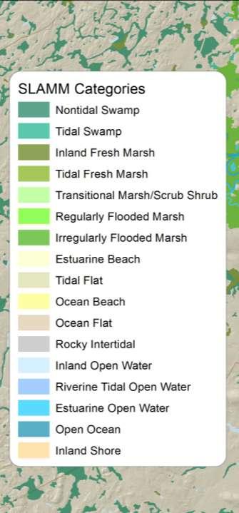
16 Chase Garden Creek Dennis Intermediate High SLR Static accretion Impervious Surface Select SLAMM Classes Upland Tidal Swamp Trans. Marsh/Scrub-Shrub Regularly-Flooded Marsh Irregularly-Flooded Marsh Non-tidal Swamp Inland Fresh Marsh 2011 D R A F T
17 Chase Garden Creek Dennis Intermediate High SLR Static accretion Impervious Surface Select SLAMM Classes Upland Tidal Swamp Trans. Marsh/Scrub-Shrub Regularly-Flooded Marsh Irregularly-Flooded Marsh Non-tidal Swamp Inland Fresh Marsh 2030 D R A F T

18 Chase Garden Creek Dennis Intermediate High SLR Static accretion Impervious Surface Select SLAMM Classes Upland Tidal Swamp Trans. Marsh/Scrub-Shrub Regularly-Flooded Marsh Irregularly-Flooded Marsh Non-tidal Swamp Inland Fresh Marsh 2050 D R A F T

19 Chase Garden Creek Dennis Intermediate High SLR Static accretion Impervious Surface Select SLAMM Classes Upland Tidal Swamp Trans. Marsh/Scrub-Shrub Regularly-Flooded Marsh Irregularly-Flooded Marsh Non-tidal Swamp Inland Fresh Marsh 2070 D R A F T

20 Chase Garden Creek Dennis Intermediate High SLR Static accretion Impervious Surface Select SLAMM Classes Upland Tidal Swamp Trans. Marsh/Scrub-Shrub Regularly-Flooded Marsh Irregularly-Flooded Marsh Non-tidal Swamp Inland Fresh Marsh 2100 D R A F T

21 Marsh Migration Potential Intermediate High SLR Static accretion Impervious Surface Select SLAMM Classes Upland Tidal Swamp Trans. Marsh/Scrub-Shrub Regularly-Flooded Marsh Irregularly-Flooded Marsh Non-tidal Swamp Inland Fresh Marsh 2100 Marsh-Upland Border D R A F T
22 Marsh Migration Potential Intermediate High SLR Static accretion Impervious Surface Select SLAMM Classes Upland Tidal Swamp Trans. Marsh/Scrub-Shrub Regularly-Flooded Marsh Irregularly-Flooded Marsh Non-tidal Swamp Inland Fresh Marsh 2100 Marsh-Upland Border D R A F T

23 Marsh Migration Potential Intermediate High SLR Static accretion Lidar DEM 10 m 5 m -0.5 m Marsh-Upland Border Impervious Surface D R A F T

24 Cape Cod SLAMM Project Panels Nauset Marsh
25 Nauset Marsh Eastham Intermediate High SLR Static accretion 2011 Impervious Surface Select SLAMM Classes Upland Tidal Swamp Trans. Marsh/Scrub-Shrub Regularly-Flooded Marsh Irregularly-Flooded Marsh Non-tidal Swamp Inland Fresh Marsh D R A F T

26 Nauset Marsh Eastham Intermediate High SLR Static accretion 2030 Impervious Surface Select SLAMM Classes Upland Tidal Swamp Trans. Marsh/Scrub-Shrub Regularly-Flooded Marsh Irregularly-Flooded Marsh Non-tidal Swamp Inland Fresh Marsh D R A F T

27 Nauset Marsh Eastham Intermediate High SLR Static accretion 2050 Impervious Surface Select SLAMM Classes Upland Tidal Swamp Trans. Marsh/Scrub-Shrub Regularly-Flooded Marsh Irregularly-Flooded Marsh Non-tidal Swamp Inland Fresh Marsh D R A F T

28 Nauset Marsh Eastham Intermediate High SLR Static accretion 2070 Impervious Surface Select SLAMM Classes Upland Tidal Swamp Trans. Marsh/Scrub-Shrub Regularly-Flooded Marsh Irregularly-Flooded Marsh Non-tidal Swamp Inland Fresh Marsh D R A F T

29 Nauset Marsh Eastham Intermediate High SLR Static accretion 2100 Impervious Surface Select SLAMM Classes Upland Tidal Swamp Trans. Marsh/Scrub-Shrub Regularly-Flooded Marsh Irregularly-Flooded Marsh Non-tidal Swamp Inland Fresh Marsh D R A F T


30 Potential Wetland Distribution by 2100 Under Four SLR Scenarios Parkers River, Yarmouth Low ~ 0.8 ft Int Low ~ 2.3 ft Int High ~ 4.5 ft High ~ 7.1 ft D R A F T


31 Anticipated Outcomes O u t r e a c h & E d u c a t i o n P o l i c y L a n d C o n s e r v a t i o n & Management R e s t o r a t i o n S p e c i e s C o n s e r v a t i o n B l u e C a r b o n A c c o u n t i n g


32 Anticipated Outcomes O u t r e a c h & E d u c a t i o n P o l i c y Land C o n s e r v a t i o n & Management R e s t o r a t i o n S p e c i e s C o n s e r v a t i o n B l u e C a r b o n A c c o u n t i n g

33 Anticipated Outcomes O u t r e a c h & E d u c a t i o n P o l i c y Land C o n s e r v a t i o n & Management R e s t o r a t i o n S p e c i e s C o n s e r v a t i o n B l u e C a r b o n A c c o u n t i n g


34 Anticipated Outcomes O u t r e a c h & E d u c a t i o n P o l i c y Land C o n s e r v a t i o n & Management R e s t o r a t i o n S p e c i e s C o n s e r v a t i o n B l u e C a r b o n A c c o u n t i n g Photo: Delaware DNREC


35 Anticipated Outcomes O u t r e a c h & E d u c a t i o n P o l i c y Land C o n s e r v a t i o n & Management R e s t o r a t i o n S p e c i e s C o n s e r v a t i o n B l u e C a r b o n A c c o u n t i n g Illustration: Mass Audubon Photo: David Johnson


36 Anticipated Outcomes O u t r e a c h & E d u c a t i o n P o l i c y Land C o n s e r v a t i o n & Management R e s t o r a t i o n S p e c i e s C o n s e r v a t i o n B l u e C a r b o n A c c o u n t i n g Illustration: The Blue Carbon Initiative s Coastal Blue Carbon


37 Project website Next Steps Final SLAMM report Overview and highlights Additional data analyses and summaries Esri Story Map and MORIS web tools Stakeholder meetings Long-term monitoring projects Remote sensing and field-based <insert pic of CZM wetlands landing page, example Esri Story Map, etc.
 Marine Biological Laboratory (MBL) Plum Island Ecosystems Long Term Research")
38 Acknowledgements Funding U.S. EPA Region 1 NOAA Office for Coastal Management Project Team MA CZM MA DFG - Division of Ecological Restoration (MA DER) Marine Biological Laboratory (MBL) Plum Island Ecosystems Long Term Research (PIE LTER) Project MassDEP Woods Hole Group Data Contributors MBL/PIE LTER USFWS Parker River NWR NPS Cape Cod NS MassDOT MA DER Waquoit Bay NERR NOAA (CO-OPS) OPS) Woods Hole Group University of South Carolina Jim Morris Warren Pinnacle Consulting, Inc. SLAMM 6.2 James Morris, University of South Carolina MEM marc.carullo@state.ma.us
Modeling the Effects of Sea Level Rise on Massachusetts Coastal Wetlands Improving Protection, Management, and Climate Change Adaptation Planning
 Modeling the Effects of Sea Level Rise on Massachusetts Coastal Wetlands Improving Protection, Management, and Climate Change Adaptation Planning Photo credit: Mike McHugh, MassDEP Marc Carullo Massachusetts
Application of the Sea-Level Affecting Marshes Model (SLAMM 6) to Back Bay NWR
 to Back Bay NWR") Application of the Sea-Level Affecting Marshes Model (SLAMM 6) to Back Bay NWR U. S. Fish and Wildlife Service National Wildlife Refuge System Division of Natural Resources and Conservation Planning Conservation
Application of the Sea-Level Affecting Marshes Model (SLAMM 6) to Back Bay NWR U. S. Fish and Wildlife Service National Wildlife Refuge System Division of Natural Resources and Conservation Planning Conservation
Application of the Sea-Level Affecting Marshes Model (SLAMM 6) to Texas Point NWR
 to Texas Point NWR") Application of the Sea-Level Affecting Marshes Model (SLAMM 6) to Texas Point NWR U. S. Fish and Wildlife Service National Wildlife Refuge System Division of Natural Resources and Conservation Planning
Application of the Sea-Level Affecting Marshes Model (SLAMM 6) to Texas Point NWR U. S. Fish and Wildlife Service National Wildlife Refuge System Division of Natural Resources and Conservation Planning
Sea Level Rise Providing Nature A-Right-of Way
 Sea Level Rise Providing Nature A-Right-of Way Study Area Site 2: Skagit Bay Initial Condition 11.2 Inches by 2050 No Dikes 27.3 Inches by 2100 No Dikes The Problem Loss of coastal wetlands due to submergence
Sea Level Rise and the Scarborough Marsh Scarborough Land Trust Annual Meeting April 24, 2018
 Sea Level Rise and the Scarborough Marsh Scarborough Land Trust Annual Meeting April 24, 2018 Peter A. Slovinsky, Marine Geologist Maine Geological Survey Funded by: 50% 40% Figure modified from Griggs,
Application of the Sea-Level Affecting Marshes Model (SLAMM 6) to John Heinz NWR
 to John Heinz NWR") Application of the Sea-Level Affecting Marshes Model (SLAMM 6) to John Heinz NWR Prepared for: U. S. Fish and Wildlife Service National Wildlife Refuge System Division of Natural Resources and Conservation
Application of the Sea-Level Affecting Marshes Model (SLAMM 6) to John Heinz NWR Prepared for: U. S. Fish and Wildlife Service National Wildlife Refuge System Division of Natural Resources and Conservation
Sea Level Affecting Marshes Model (SLAMM) for Coastal Long Island Sound:
 for Coastal Long Island Sound:") 2100 DATA VIEWER MANUAL Sea Level Affecting Marshes Model (SLAMM) for Coastal Long Island Sound: Using a Web Mapping Application Data Viewer to Examine Predicted Land Cover Change for 2100 AUTHOR: KEVIN
2100 DATA VIEWER MANUAL Sea Level Affecting Marshes Model (SLAMM) for Coastal Long Island Sound: Using a Web Mapping Application Data Viewer to Examine Predicted Land Cover Change for 2100 AUTHOR: KEVIN
Appendix B. SLAMM Analysis of Kenai Peninsula and Anchorage, AK. Final Report
 Appendix B SLAMM Analysis of Kenai Peninsula and Anchorage, AK Final Report For: Jim Adams Director, Pacific Region National Wildlife Federation Anchorage, AK And: David Wigglesworth Coastal Program Manager
Application of the Sea-Level Affecting Marshes Model (SLAMM 6) to Pelican Island NWR
 to Pelican Island NWR") Application of the Sea-Level Affecting Marshes Model (SLAMM 6) to Pelican Island NWR U. S. Fish and Wildlife Service National Wildlife Refuge System Division of Natural Resources and Conservation Planning
Application of the Sea-Level Affecting Marshes Model (SLAMM 6) to Pelican Island NWR U. S. Fish and Wildlife Service National Wildlife Refuge System Division of Natural Resources and Conservation Planning
The Use of Geographic Information Systems to Assess Change in Salt Marsh Ecosystems Under Rising Sea Level Scenarios.
 The Use of Geographic Information Systems to Assess Change in Salt Marsh Ecosystems Under Rising Sea Level Scenarios Robert Hancock The ecological challenges presented by global climate change are vast,
Sea-level Rise on Cape Cod: How Vulnerable Are We? Rob Thieler U.S. Geological Survey Woods Hole, MA
 Sea-level Rise on Cape Cod: How Vulnerable Are We? Rob Thieler U.S. Geological Survey Woods Hole, MA Outline Sea-level and coastal processes Past sea-level change Predictions for the future Coastal responses
Mangrove Restoration and Migration in a Changing Climate: Climatic Drivers and Shifting Ecotones
 Mangrove Restoration and Migration in a Changing Climate: Climatic Drivers and Shifting Ecotones Michael J. Osland & Richard H. Day U.S. Geological Survey, National Wetlands Research Center U.S. Department
Application of the Sea-Level Affecting Marshes Model (SLAMM 5.1) to San Diego Bay NWR
 to San Diego Bay NWR") Application of the Sea-Level Affecting Marshes Model (SLAMM 5.1) to San Diego Bay NWR Prepared For: Dr. Brian Czech, Conservation Biologist U. S. Fish and Wildlife Service National Wildlife Refuge System
Application of the Sea-Level Affecting Marshes Model (SLAMM 5.1) to San Diego Bay NWR Prepared For: Dr. Brian Czech, Conservation Biologist U. S. Fish and Wildlife Service National Wildlife Refuge System
Application of the Sea-Level Affecting Marshes Model (SLAMM 5.0) to Bon Secour National Wildlife Refuge
 to Bon Secour National Wildlife Refuge") Application of the Sea-Level Affecting Marshes Model (SLAMM 5.0) to Bon Secour National Wildlife Refuge Prepared For: Dr. Brian Czech, Conservation Biologist U. S. Fish and Wildlife Service National Wildlife
Application of the Sea-Level Affecting Marshes Model (SLAMM 5.0) to Bon Secour National Wildlife Refuge Prepared For: Dr. Brian Czech, Conservation Biologist U. S. Fish and Wildlife Service National Wildlife
Tony Pratt, DNREC to The Center for the Inland Bays Scientific and Technical Advisory Committee. August 21, 2009
 Sea Level Rise in Delaware Presented by Tony Pratt, DNREC to The Center for the Inland Bays Scientific and Technical Advisory Committee August 21, 2009 Sea level has been fluctuating ever since there have
Application of the Sea-Level Affecting Marshes Model (SLAMM 6) to Currituck NWR
 to Currituck NWR") Application of the Sea-Level Affecting Marshes Model (SLAMM 6) to Currituck NWR U. S. Fish and Wildlife Service National Wildlife Refuge System Division of Natural Resources and Conservation Planning Conservation
Application of the Sea-Level Affecting Marshes Model (SLAMM 6) to Currituck NWR U. S. Fish and Wildlife Service National Wildlife Refuge System Division of Natural Resources and Conservation Planning Conservation
Application of the Sea-Level Affecting Marshes Model (SLAMM 6) to Crocodile Lake NWR
 to Crocodile Lake NWR") Application of the Sea-Level Affecting Marshes Model (SLAMM 6) to Crocodile Lake NWR U. S. Fish and Wildlife Service National Wildlife Refuge System Division of Natural Resources and Conservation Planning
Application of the Sea-Level Affecting Marshes Model (SLAMM 6) to Crocodile Lake NWR U. S. Fish and Wildlife Service National Wildlife Refuge System Division of Natural Resources and Conservation Planning
Evaluation of Regional SLAMM Results to Establish a Consistent Framework of Data and Models
 Evaluation of Regional SLAMM Results to Establish a Consistent Framework of Data and Models Prepared for the Gulf Coast Prairie Landscape Conservation Cooperative June, 2015 Minor Revisions, March 2016
Coastal Processes 101. Greg Berman (Woods Hole Sea Grant & Cape Cod Cooperative Extension)
") Coastal Processes 101 Greg Berman (Woods Hole Sea Grant & Cape Cod Cooperative Extension) January 23, 2019 Coastal Processes 101 Outline: ~30 min talk Coastal Processes What is Erosion? Value of the Ecosystem
Coastal Processes 101 Greg Berman (Woods Hole Sea Grant & Cape Cod Cooperative Extension) January 23, 2019 Coastal Processes 101 Outline: ~30 min talk Coastal Processes What is Erosion? Value of the Ecosystem
Current and Future Technology Applications for Coastal Zone Management. Bruce K. Carlisle, Acting Director Office of Coastal Zone Management
 Current and Future Technology Applications for Coastal Zone Management Bruce K. Carlisle, Acting Director Office of Coastal Zone Management The Massachusetts Coastal Zone Management Program Approved in
Preliminary Results from Coordinated Sea-Level Rise Modeling Using SLAMM, the Sea Level Affecting Marshes Model, Across the US Gulf of Mexico Coast
 Preliminary Results from Coordinated Sea-Level Rise Modeling Using SLAMM, the Sea Level Affecting Marshes Model, Across the US Gulf of Mexico Coast James W. Pahl, Ph.D., and Kristin DeMarco, State of Louisiana
Increasing Salt Marsh Resilience in the Face of SLR Investigating Thin Layer Deposition (Sediment Augmentation) as a Management Technique
 as a Management Technique") Increasing Salt Marsh Resilience in the Face of SLR Investigating Thin Layer Deposition (Sediment Augmentation) as a Management Technique Megan Tyrrell Waquoit Bay National Estuarine Research Reserve Coastal
Increasing Salt Marsh Resilience in the Face of SLR Investigating Thin Layer Deposition (Sediment Augmentation) as a Management Technique Megan Tyrrell Waquoit Bay National Estuarine Research Reserve Coastal
Application of SLAMM to Coastal Connecticut. Final Report
 Application of SLAMM to Coastal Connecticut Final Report Prepared for: New England Interstate Water Pollution Control Commission Lowell, MA Emily Bird Project Manager Environmental Analyst Prepared by:
Application of the Sea-Level Affecting Marshes Model (SLAMM 6) to Potomac River NWR Complex
 to Potomac River NWR Complex") Application of the Sea-Level Affecting Marshes Model (SLAMM 6) to Potomac River NWR Complex U. S. Fish and Wildlife Service National Wildlife Refuge System Division of Natural Resources and Conservation
Application of the Sea-Level Affecting Marshes Model (SLAMM 6) to Potomac River NWR Complex U. S. Fish and Wildlife Service National Wildlife Refuge System Division of Natural Resources and Conservation
Everglades National Park
 National Park Service U.S. Department of the Interior Climate Variability and the Coastal Physical Environment (Florida Bay) Presented by: Erik Stabenau - National Park Service Contributions from: Christina
Application of the Sea-Level Affecting Marshes Model (SLAMM 5.0) to Green Cay National Wildlife Refuge
 to Green Cay National Wildlife Refuge") Application of the Sea-Level Affecting Marshes Model (SLAMM 5.0) to Green Cay National Wildlife Refuge Prepared For: Dr. Brian Czech, Conservation Biologist U. S. Fish and Wildlife Service National Wildlife
Application of the Sea-Level Affecting Marshes Model (SLAMM 5.0) to Green Cay National Wildlife Refuge Prepared For: Dr. Brian Czech, Conservation Biologist U. S. Fish and Wildlife Service National Wildlife
Analysis of Tides and Storm Surge from Observational Records in the Delaware Inland Bays
 Analysis of Tides and Storm Surge from Observational Records in the Delaware Inland Bays John Callahan Delaware Geological Survey Coastal GeoTools Conference March 30 April 2, 2015 Charleston, SC Outline
Adaptation to Sea Level Rise A Regional Approach
 Adaptation to Sea Level Rise A Regional Approach Project Partners: in Saco Bay, ME Peter Slovinsky, Marine Geologist Maine Geological Survey, Department of Conservation Project Funding from: Saco Bay Hazards
Application of the Sea-Level Affecting Marshes Model (SLAMM 6) to Ten Thousand Islands NWR
 to Ten Thousand Islands NWR") Application of the Sea-Level Affecting Marshes Model (SLAMM 6) to Ten Thousand Islands NWR Prepared for Gulf of Mexico Alliance Habitat Conservation and Restoration Priority Issue Team Corpus Christi,
Application of the Sea-Level Affecting Marshes Model (SLAMM 6) to Ten Thousand Islands NWR Prepared for Gulf of Mexico Alliance Habitat Conservation and Restoration Priority Issue Team Corpus Christi,
Application of the Sea-Level Affecting Marshes Model (SLAMM 6) to MS Sandhill Crane NWR
 to MS Sandhill Crane NWR") Application of the Sea-Level Affecting Marshes Model (SLAMM 6) to MS Sandhill Crane NWR Prepared for Gulf of Mexico Alliance Habitat Conservation and Restoration Priority Issue Team Corpus Christi, TX
Application of the Sea-Level Affecting Marshes Model (SLAMM 6) to MS Sandhill Crane NWR Prepared for Gulf of Mexico Alliance Habitat Conservation and Restoration Priority Issue Team Corpus Christi, TX
9 th INTECOL Orlando, Florida June 7, 2012
 Restoration of the Everglades Saline Wetlands and Florida Bay: Responses Driven from Land and Sea David Rudnick 1, Colin Saunders 2, Carlos Coronado 2, Fred Sklar 2 Erik Stabenau 1, Vic Engel 1, Rene Price
Shoreline Mapping & Erosion Patterns. Julia Knisel Julia Knisel Coastal Shoreline & Floodplain Manager
 Shoreline Mapping & Erosion Patterns Along the Massachusetts Coast Julia Knisel Julia Knisel Coastal Shoreline & Floodplain Manager CZM Shoreline Change Project Timeline 1989: produced coast wide maps
Application of the Sea-Level Affecting Marshes Model (SLAMM 6) to Guam NWR
 to Guam NWR") Application of the Sea-Level Affecting Marshes Model (SLAMM 6) to Guam NWR Prepared For U. S. Fish and Wildlife Service National Wildlife Refuge System Division of Natural Resources and Conservation Planning
Application of the Sea-Level Affecting Marshes Model (SLAMM 6) to Guam NWR Prepared For U. S. Fish and Wildlife Service National Wildlife Refuge System Division of Natural Resources and Conservation Planning
THIN-LAYER PLACEMENT OF DREDGE MATERIAL FOR MARSH NOURISHMENT, RESOTRATION, AND RESPONSE TO SEA LEVEL RISE
 THIN-LAYER PLACEMENT OF DREDGE MATERIAL FOR MARSH NOURISHMENT, RESOTRATION, AND RESPONSE TO SEA LEVEL RISE Case studies and lesson learned regarding thin-layer deposition projects in Delaware, New Jersey,
Application of the Sea-Level Affecting Marshes Model (SLAMM 5.1) to Seatuck NWR
 to Seatuck NWR") Application of the Sea-Level Affecting Marshes Model (SLAMM 5.1) to Seatuck NWR Prepared For: Dr. Brian Czech, Conservation Biologist U. S. Fish and Wildlife Service National Wildlife Refuge System Division
Application of the Sea-Level Affecting Marshes Model (SLAMM 5.1) to Seatuck NWR Prepared For: Dr. Brian Czech, Conservation Biologist U. S. Fish and Wildlife Service National Wildlife Refuge System Division
Primer on Coastal Erosion And Habitat Creation
 2 nd Regional Conference Dredging, Beach Nourishment & Bird Conservation Primer on Coastal Erosion And Habitat Creation Timothy Kana Ph.D Source: Newsday 1962 Photo by Kelsey Aerials 1978 Source: U Mass
Taunton River Salt Marsh Assessment Results from 2014 season
 Taunton River Salt Marsh Assessment Results from 2014 season December, 2014 During the late summer and fall of 2014, Save The Bay evaluated salt marshes in Assonet Bay, Freetown and Broad Cove in Dighton
Enhancing Coastal Resilience on Virginia s Eastern Shore: Application of the Sea-Level Affecting Marshes Model
 Enhancing Coastal Resilience on Virginia s Eastern Shore: Application of the Sea-Level Affecting Marshes Model Prepared for: The Nature Conservancy Charlottesville, VA Gwynn Crichton Sr. Project Scientist
Application of the Sea-Level Affecting Marshes Model (SLAMM 6) to Don Edwards NWR
 to Don Edwards NWR") Application of the Sea-Level Affecting Marshes Model (SLAMM 6) to Don Edwards NWR Prepared For: Dr. Brian Czech, Conservation Biologist U. S. Fish and Wildlife Service National Wildlife Refuge System Division
Application of the Sea-Level Affecting Marshes Model (SLAMM 6) to Don Edwards NWR Prepared For: Dr. Brian Czech, Conservation Biologist U. S. Fish and Wildlife Service National Wildlife Refuge System Division
Assessing the Permanence of Blue Carbon Sinks
 Assessing the Permanence of Blue Carbon Sinks with Rising Sea Levels Gail L. Chmura and Dante D. Torio Department of Geography, McGill University and Global Environmental and Climate Change Centre Montreal,
Application of the Sea-Level Affecting Marshes Model (SLAMM 5.0) to Cabo Rojo and Laguna Cartagena National Wildlife Refuge
 to Cabo Rojo and Laguna Cartagena National Wildlife Refuge") Application of the Sea-Level Affecting Marshes Model (SLAMM 5.0) to Cabo Rojo and Laguna Cartagena National Wildlife Refuge Prepared For: Dr. Brian Czech, Conservation Biologist U. S. Fish and Wildlife
Application of the Sea-Level Affecting Marshes Model (SLAMM 5.0) to Cabo Rojo and Laguna Cartagena National Wildlife Refuge Prepared For: Dr. Brian Czech, Conservation Biologist U. S. Fish and Wildlife
Bob Van Dolah. Marine Resources Research Institute South Carolina Department of Natural Resources
 Bob Van Dolah Marine Resources Research Institute South Carolina Department of Natural Resources Shoreline Change Will Occur! On our front beaches where it is not easy to retreat Shoreline Change Will
Presentation Outline. Project Overview. Sea Level Rise Assessment & Decision Tools. Community Engagement. Tina Whitman, Friends of the San Juans
 Healthy Beaches for People & Fish Sea Level Rise Adaptation Tools for San Juan County, WA Tina Whitman & Andrea MacLennan December 10, 2015 Presentation Outline Project Overview Tina Whitman, Friends of
Evaluation of Regional SLAMM Results to Establish a Consistent Framework of Data and Models
 Evaluation of Regional SLAMM Results to Establish a Consistent Framework of Data and Models Gulf Coast Prairie Land Conservation Cooperative December 15, 2014 PO Box 315, Waitsfield VT, 05673 (802)-496-3476
exposed has to the this soil lowest water salinity. However in the fall, following a lot of Underground
 How deep it collects from Background information for Data Analysis for Mass Audubon s Salt Marsh Science Project* We are measuring salinity at different depths to see what conditions Phragmites, and other
Coastal Processes 101 & The Regs. Greg Berman (Woods Hole Sea Grant & Cape Cod Cooperative Extension)
") Coastal Processes 101 & The Regs Greg Berman (Woods Hole Sea Grant & Cape Cod Cooperative Extension) March 26, 2019 Coastal Processes 101 & The Regs Outline: ~15 min talk Coastal Processes What is Erosion?
Coastal Processes 101 & The Regs Greg Berman (Woods Hole Sea Grant & Cape Cod Cooperative Extension) March 26, 2019 Coastal Processes 101 & The Regs Outline: ~15 min talk Coastal Processes What is Erosion?
Mapping of Future Coastal Hazards. for Southern California. January 7th, David Revell, Ph.D. E.
 Mapping of Future Coastal Hazards for Southern California January 7th, 2014 David Revell, Ph.D. drevell@esassoc.com E. Vandebroek, 2012 Outline Coastal erosion hazard zones Flood hazard zones: Coastal
:: STUDENTS SUPPORTED
 PROGRESS REPORT REPORT PERIOD: 2/1/2014-1/31/2015 PROJECT NO: 2014-R/P-NERR-14-2-REG TITLE: Coastal Hazards and Northeast Housing Values: Comparative Implications for Climate Change Adaptation and Community
Assessing the Vulnerability of Alaska s Coastal Habitats to Accelerating Sea-level Rise Using the SLAMM Model: A Case Study for Cook Inlet
 Assessing the Vulnerability of Alaska s Coastal Habitats to Accelerating Sea-level Rise Using the SLAMM Model: A Case Study for Cook Inlet Photo by: David Wigglesworth, USFWS Region 7 Coastal Program Prepared
Application of the Sea-Level Affecting Marshes Model (SLAMM 6) to Huleia NWR
 to Huleia NWR") Application of the Sea-Level Affecting Marshes Model (SLAMM 6) to Huleia NWR Prepared For U. S. Fish and Wildlife Service National Wildlife Refuge System Division of Natural Resources and Conservation
Application of the Sea-Level Affecting Marshes Model (SLAMM 6) to Huleia NWR Prepared For U. S. Fish and Wildlife Service National Wildlife Refuge System Division of Natural Resources and Conservation
Application of the Sea-Level Affecting Marshes Model (SLAMM 6) to Kilauea Point NWR
 to Kilauea Point NWR") Application of the Sea-Level Affecting Marshes Model (SLAMM 6) to Kilauea Point NWR Prepared For U. S. Fish and Wildlife Service National Wildlife Refuge System Division of Natural Resources and Conservation
Application of the Sea-Level Affecting Marshes Model (SLAMM 6) to Kilauea Point NWR Prepared For U. S. Fish and Wildlife Service National Wildlife Refuge System Division of Natural Resources and Conservation
4.2 Tidal Wetlands. Phragmites Australis
 4.2 Tidal Wetlands Few topics elicit such strong emotions in Guilford as the current state of salt marshes. These marshes, more broadly known as tidal wetlands, are undergoing a transformation as sea level
Ecosystems Chapter 4. What is an Ecosystem? Section 4-1
 Ecosystems Chapter 4 What is an Ecosystem? Section 4-1 Ecosystems Key Idea: An ecosystem includes a community of organisms and their physical environment. A community is a group of various species that
Protecting the Storm Damage Prevention and Flood Control Interests of Coastal Resource Areas
 Protecting the Storm Damage Prevention and Flood Control Interests of Coastal Resource Areas Presented by: Massachusetts Department of Environmental Protection & Massachusetts Office of Coastal Zone Management
Developed in Consultation with Florida Educators
 Developed in Consultation with Florida Educators Table of Contents Next Generation Sunshine State Standards Correlation Chart... 7 Benchmarks Chapter 1 The Practice of Science...................... 11
Appendix E: Cowardin Classification Coding System
 Appendix E: Cowardin Classification Coding System The following summarizes the Cowardin classification coding system and the letters and numbers used to define the USFWS NWI wetland types and subtypes:
Application of the Sea-Level Affecting Marshes Model (SLAMM 5.0) to Salinas River NWR
 to Salinas River NWR") Application of the Sea-Level Affecting Marshes Model (SLAMM 5.0) to Salinas River NWR Prepared For: Dr. Brian Czech, Conservation Biologist U. S. Fish and Wildlife Service National Wildlife Refuge System
Application of the Sea-Level Affecting Marshes Model (SLAMM 5.0) to Salinas River NWR Prepared For: Dr. Brian Czech, Conservation Biologist U. S. Fish and Wildlife Service National Wildlife Refuge System
Section 145 Climate Change and Sea Level Rise
 Section 145 Climate Change and Sea Level Rise A. Definitions Rhode Island Coastal Resources Management Program 1. Climate is the long-term weather average observed within a geographic region, and climate
Application of the Sea-Level Affecting Marshes Model (SLAMM 6) to Pearl Harbor NWR
 to Pearl Harbor NWR") Application of the Sea-Level Affecting Marshes Model (SLAMM 6) to Pearl Harbor NWR Prepared For: Dr. Brian Czech, Conservation Biologist U. S. Fish and Wildlife Service National Wildlife Refuge System
Application of the Sea-Level Affecting Marshes Model (SLAMM 6) to Pearl Harbor NWR Prepared For: Dr. Brian Czech, Conservation Biologist U. S. Fish and Wildlife Service National Wildlife Refuge System
Use of Remote Sensing and GIS for Wetland, Riparian, and Watershed Assessment, Restoration, and Monitoring
 Use of Remote Sensing and GIS for Wetland, Riparian, and Watershed Assessment, Restoration, and Monitoring Ralph Tiner Wetland Ecologist U.S. Fish & Wildlife Service National Wetlands Inventory Program
Assessing ecological integrity of salt marshes in the Northeast
 Assessing ecological integrity of salt marshes in the Northeast A project of the North Atlantic Landscape Conservation Cooperative Bradley W. Compton Department of Environmental Conservation University
Types of Wetlands. Tidal Systems
 Types of Wetlands Tidal Systems 1 COASTAL WETLAND ECOSYSTEMS Tidal Salt Marshes Tidal Freshwater Marshes Mangrove Wetlands 2 Tidal Estuarine Wetland 3 Definition and Formation of Estuaries Estuary: : partially
Application of the Sea-Level Affecting Marshes Model (SLAMM 6) to Bandon Marsh NWR
 to Bandon Marsh NWR") Application of the Sea-Level Affecting Marshes Model (SLAMM 6) to Bandon Marsh NWR Prepared For: Dr. Brian Czech, Conservation Biologist U. S. Fish and Wildlife Service National Wildlife Refuge System
Application of the Sea-Level Affecting Marshes Model (SLAMM 6) to Bandon Marsh NWR Prepared For: Dr. Brian Czech, Conservation Biologist U. S. Fish and Wildlife Service National Wildlife Refuge System
Subtidal permanently flooded with tidal water. Irregularly exposed surface exposed by tides less often than daily
 Types of Wetlands Tidal Systems COASTAL WETLAND ECOSYSTEMS Tidal Salt Marshes Tidal Freshwater Marshes Mangrove Wetlands Tidal Estuarine Wetland 1 Definition and Formation of Estuaries u Estuary : partially
Application of the Sea-Level Affecting Marshes Model (SLAMM 5.0) to Guadalupe-Nipomo Dunes NWR
 to Guadalupe-Nipomo Dunes NWR") Application of the Sea-Level Affecting Marshes Model (SLAMM 5.0) to Guadalupe-Nipomo Dunes NWR Prepared For: Dr. Brian Czech, Conservation Biologist U. S. Fish and Wildlife Service National Wildlife Refuge
Application of the Sea-Level Affecting Marshes Model (SLAMM 5.0) to Guadalupe-Nipomo Dunes NWR Prepared For: Dr. Brian Czech, Conservation Biologist U. S. Fish and Wildlife Service National Wildlife Refuge
Baseline Estuarine-Upland Transition Zone
 Baseline Estuarine-Upland Transition Zone in SF, San Pablo and Suisun Bays 10/5/18 Prepared for San Francisco Bay Joint Venture (SFBJV) Prepared by Brian Fulfrost, Principal bfaconsult@gmail.com with additional
USGS efforts to model sea-level rise impact to tidal marshes along the California coast.
 USGS efforts to model sea-level rise impact to tidal marshes along the California coast. Karen Thorne 1 J.Y Takekawa 1, K. Buffington 1, K. Swanson 2, J. Drexler 2, D.Schoellhamer 2, M. Casazza 3, and
Sea Level Rise in Miami-Dade County Florida Implications for Management of Coastal Wetlands and the Everglades
 Sea Level Rise in Miami-Dade County Florida Implications for Management of Coastal Wetlands and the Everglades Peter W. Harlem Dr. John F. Meeder Florida International University Southeast Environmental
Addendum to the Essex and South Suffolk Second Generation Shoreline Management Plan
 Addendum to the Essex and South Suffolk Second Generation Shoreline Management Plan September 2012 CONTENTS 1. Introduction 1 2. Changes in saltmarsh habitat 1 3. Preferred managed realignment policy options
GALVESTON BAY RSM Moving toward an Integrated, Cooperative, and Holistic Approach to Estuarine Sediments
 GALVESTON BAY RSM Moving toward an Integrated, Cooperative, and Holistic Approach to Estuarine Sediments RAE Conference 2010 Larry A. Wise Moffatt & Nichol RSM is a system-based approach for collaboratively
The rate and fate of coastal carbon burial
 The rate and fate of coastal carbon burial Matthew L. Kirwan, Virginia Institute of Marine Science Main Points Marsh size Marsh accretion 1. SLR drives wetland carbon burial in vertical and lateral dimensions
CHAPTER 6 & 7 VOCABULARY
 CHAPTER 6 & 7 VOCABULARY 1. Biome 2. Climate 3. Latitude 4. Altitude 5. Emergent layer 6. Epiphyte 7. Understory 8. Permafrost 9. Wetland 10.Plankton 11.Nekton 12.Benthos 13.Littoral zone 14.Benthic zone
COASTAL DATA APPLICATION
 2015 Coastal GeoTools Proactive By Design. Our Company Commitment COASTAL DATA APPLICATION Projecting Future Coastal Flood Risk for Massachusetts Bay Bin Wang, Tianyi Liu, Daniel Stapleton & Michael Mobile
National Wetlands Inventory Update for New England 2009
 National Wetlands Inventory Update for New England 2009 Ralph Tiner Wetland Ecologist U.S. Fish & Wildlife Service National Wetlands Inventory Program Where we ve been Maps Status and trends investigations
Planning for Sea Level Rise in the Matanzas Basin
 Planning for Sea Level Rise in the Matanzas Basin Appendix C: Application of the Sea Level Affecting Marshes Model (SLAMM) in the Matanzas Basin June, 2015 Prepared by: Dr. Anna Cathey Linhoss and Dr.
Sea Level Rise and Hurricane Florence storm surge research methodology
 Sea Level Rise and Hurricane Florence storm surge research methodology Hurricane Florence storm surge analysis was conducted using a variety of input sources. In order to determine the maximum storm surge
Town of Old Orchard Beach: A summary of sea level rise science, storm surge, and some highlighted results from SLAWG work efforts
 Town of Old Orchard Beach: A summary of sea level rise science, storm surge, and some highlighted results from SLAWG work efforts October 15, 2013 Peter A. Slovinsky, Marine Geologist Maine Geological
Planning for the Future of Humboldt Bay: Sea Level Rise, Sediment Management, Sand Spits and Salt Marshes. Joel Gerwein
 Planning for the Future of Humboldt Bay: Sea Level Rise, Sediment Management, Sand Spits and Salt Marshes Joel Gerwein Introduction to Humboldt Bay Setting Economy, community, and environment Sediment
Carbon Sequestration Potential from Coastal Wetlands Restoration Sites
 Carbon Sequestration Potential from Coastal Wetlands Restoration Sites Insert then choose Picture select your picture. Right click your picture and Send to back. Paul Krause, Alyssa Beach Emily Cooper,
Modeling the Fate of New Jersey s Salt Marshes Under Future Sea Level Rise
 Modeling the Fate of New Jersey s Salt Marshes Under Future Sea Level Rise Richard Lathrop and John Bognar Contact: lathrop@crssa.rutgers.edu Center for Remote Sensing & Spatial Analysis, Rutgers University
Everglades National Park
 National Park Service U.S. Department of the Interior Water Budget, Climate Variability, and Predicting Salinity for Eastern Florida Bay Erik Stabenau and Kevin Kotun National Park Service Erik_Stabenau@nps.gov
Critical Coastal Habitat Assessment. Long-term monitoring in Tampa Bay
 Critical Coastal Habitat Assessment Long-term monitoring in Tampa Bay Kara Radabaugh, Ryan Moyer, Ed Sherwood, Gary Raulerson, Amanda Chappel, Taylor Nielsen, Reba Campbell, and Emma Dontis. Critical Coastal
MEMORANDUM FOR SWG
 MEMORANDUM FOR SWG-2007-1623 Subject: Jurisdictional Determination (JD) for SWG-2007-1623 on Interdunal Wetlands Adjacent to Traditional Navigable Waters (TNWs) Summary The U.S. Environmental Protection
Quantifying effects of oil on coastal dune vegetation. Thomas Miller and Elise Gornish Biological Science, Florida State University
 Quantifying effects of oil on coastal dune vegetation Thomas Miller and Elise Gornish Biological Science, Florida State University Natural History of Barrier Islands in the Northern Gulf Make up ~70% of
South Carolina Coastal Habitats
 South Carolina Coastal Habitats By C. Livingston, 2009 Earth Where is South Carolina? North America United States of America SC Here we are! South Carolina borders the Atlantic Ocean. Did you know? South
HURRICANE IRENE. CONFERENCE CALL BRIEFING SLIDES Saturday August 27, :30 AM
 HURRICANE IRENE CONFERENCE CALL BRIEFING SLIDES Saturday August 27, 2011 8:30 AM NHC TRACK AND CONE HURRICANE IRENE WATCHES/WARNINGS Hurricane Warning along south coast including all of Cape Cod and Islands
The Refugia Concept: Using Watershed Analysis to Prioritize Salmonid Habitat for Conservation and Restoration
 The Refugia Concept: Using Watershed Analysis to Prioritize Salmonid Habitat for Conservation and Restoration Christopher May Battelle & UW Cumulative Impacts of Urbanization Landscape Alterations Loss
Some Thoughts on the Role of Elevation
 Some Thoughts on the Role of Elevation Data in Sea-level Rise Impact Assessments Rob Thieler* U.S. Geological Survey Coastal and Marine Geology Program Woods Hole, MA *i l d t i l d f D C h D G h *includes
Sea Level Rise Study Summary Town of South Bethany
 Sea Level Rise Study Summary Town of South Bethany This presentation was prepared by Anchor QEA for the Town of South Bethany using Federal Funds under award NA14 NOS 419 0123 from the Delaware Coastal
GIS Data and Technology to Support Transportation & MPO Decision-Making & Planning. using an Eco-Logical* Approach within the Kansas City Region
 GIS Data and Technology to Support Transportation & MPO Decision-Making & Planning using an Eco-Logical* Approach within the Kansas City Region Authors (in alphabetical order): Tom Gerend, Tom Jacobs,
Eco-hydromorphic Characterization of the Louisiana Coastal Region Using Multiple Remotely Sensed Data Sources and Analyses
 National Wetlands Research Center Eco-hydromorphic Characterization of the Louisiana Coastal Region Using Multiple Remotely Sensed Data Sources and Analyses 1Holly Beck, 2 Brady Couvillion, 1 Nadine Trahan
ICAN Great Lakes Workshop
 Washington Coastal latlas ICAN Great Lakes Workshop September 13 15, 15 2010 Current Washington Coastal Atlas http://www.ecy.wa.gov/programs/sea/sma/atlas_home.html 1 st version of WA Coastal Atlas was
Latest trends in sea level rise and storm surges in Maine Peter A. Slovinsky, Marine Geologist
 Latest trends in sea level rise and storm surges in Maine Peter A. Slovinsky, Marine Geologist Image from Chebeague.org Maine s glacial geology and historic sea level rise trends Current sea level trends
SLAMM 6.3 Technical Documentation. Sea Level Affecting Marshes Model, Version 6.3 beta
 SLAMM 6.3 Technical Documentation Sea Level Affecting Marshes Model, Version 6.3 beta DRAFT December 11, 2012 SLAMM 6.3 Technical Documentation Sea Level Affecting Marshes Model, Version 6.3 beta Acknowledgements...
Preliminary Vulnerability Assessment of Coastal Flooding Threats - Taylor County, Florida
 Preliminary Vulnerability Assessment of Coastal Flooding Threats - Taylor County, Florida North Central Florida Regional Planning Council Northeast Florida Regional Council April 28, 2016 BACKGROUND This
Tools for Climate Change Adaptation Planning
 Adaptation base for Planning Tool (ADAPT) CRiSTAL (Community-based Risk Screening Tool Adaptation and Livelihoods) NOAA CSC Coastal Inundation Toolkit NOAA CSC Roadmap Ecosystem-Based Managment Tools Network
Remote Sensing and Spatial Analysis (RSSA)
") MESM Track Remote Sensing and Spatial Analysis (RSSA) Dr. Y.Q. Wang (Track Chair) http://nrs.uri.edu/people/faculty/wang.html Remote Sensing and Spatial Analysis Remote sensing, GIS, GPS and their applications
MESM Track Remote Sensing and Spatial Analysis (RSSA) Dr. Y.Q. Wang (Track Chair) http://nrs.uri.edu/people/faculty/wang.html Remote Sensing and Spatial Analysis Remote sensing, GIS, GPS and their applications
Physiographic Provinces (West, Ch. 13)
") Geology 229 Engineering Geology Lecture 13 Physiographic Provinces (West, Ch. 13) The definition of the term Physiography Physiography (n.) The science which treats of the earth's exterior physical features,
Geology 229 Engineering Geology Lecture 13 Physiographic Provinces (West, Ch. 13) The definition of the term Physiography Physiography (n.) The science which treats of the earth's exterior physical features,
Mapping rainfall and flooding
 Mapping rainfall and flooding BY DAVID WALBERT Although Hurricane Floyd was the biggest storm of 1999 and the one most remembered, eastern North Carolina was hit by three hurricanes in a six-week period
Chapter 3 - White Oak River Subbasin Includes Bogue Sound and the Newport River
 Chapter 3 - White Oak River Subbasin 03-05-03 Includes Bogue Sound and the Newport River 3.1 Water Quality Overview Subbasin 03-05-03 at a Glance Land and Water Area (sq. mi.) Total area: 228 Land area: