Sea Level Rise and the Scarborough Marsh Scarborough Land Trust Annual Meeting April 24, 2018
|
|
|
- Brendan Williamson
- 5 years ago
- Views:
Transcription


1 Sea Level Rise and the Scarborough Marsh Scarborough Land Trust Annual Meeting April 24, 2018 Peter A. Slovinsky, Marine Geologist Maine Geological Survey Funded by:

2 50% 40% Figure modified from Griggs, %
 30 well-studied glaciers have decreased in average thickness by 60")
3 Global Sea Level Rise Driving Factors: Volumetric Increase (melting of land-based ice sheets and glaciers) Glaciers (m of water equivalent thickness) 30 well-studied glaciers have decreased in average thickness by 60 feet
 as difference from 1990 Global sea level rise average over the last century: 1.")
4 Global Sea Level Rise Driving Factors: Thermal Expansion (expansion of the water column due heating) Ocean Heat (10 22 joules) compared with average Global sea level (mm) as difference from 1990 Global sea level rise average over the last century: 1.8 mm/year

5 Since 1993, global sea level has risen at 3.1 mm/yr


6 Locally, sea level is rising in the long term P.A. Slovinsky, Maine Geological Survey, February 2, 2018


7 is rising faster in the short term and can rise abruptly P.A. Slovinsky, Maine Geological Survey, February 2, 2018


8 Sea level can also change abruptly. Portland saw an average of approximately 5 higher than normal tides in the summer of 2009, and, especially in winter of This was the highest along the whole east coast.

9 Five of the highest monthly sea levels since 1912 occurred in winter We suspect similar conditions likely in winter Higgins Beach, Scarborough, April 7, 2010 P.A. Slovinsky
10 Global Mean Sea Level (m) Adapted from NOAA Technical Report NOS CO-OPS 083, January, 2017 and sea level is expected to continue to rise. Global Mean Sea Level Scenarios to ft Scenarios 6.6 ft 4.9 ft Satellite data 3.3 ft Tide gauge data 1.6 ft 1.0 ft

11 and in New England, may rise higher than global averages ft 8.7 ft 6.0 ft 3.8 ft 1.5 ft 1.0 ft
12 How do we simulate potential marsh migration in response to SLR?

13 LiDAR - Light Detection & Ranging Data 100,000 pulses of laser light per second are sent to the ground in sweeping lines Sensors measure how long it takes each pulse to reflect back to the unit and calculates an elevation Image from the Kelly Research and Outreach Lab, California Coastal LiDar Project Algorithms are used to remove buildings and vegetation types to create a bare earth digital elevation model (DEM)
 for")
14 LiDAR Digital Elevation Model (DEM) for Scarborough, ME


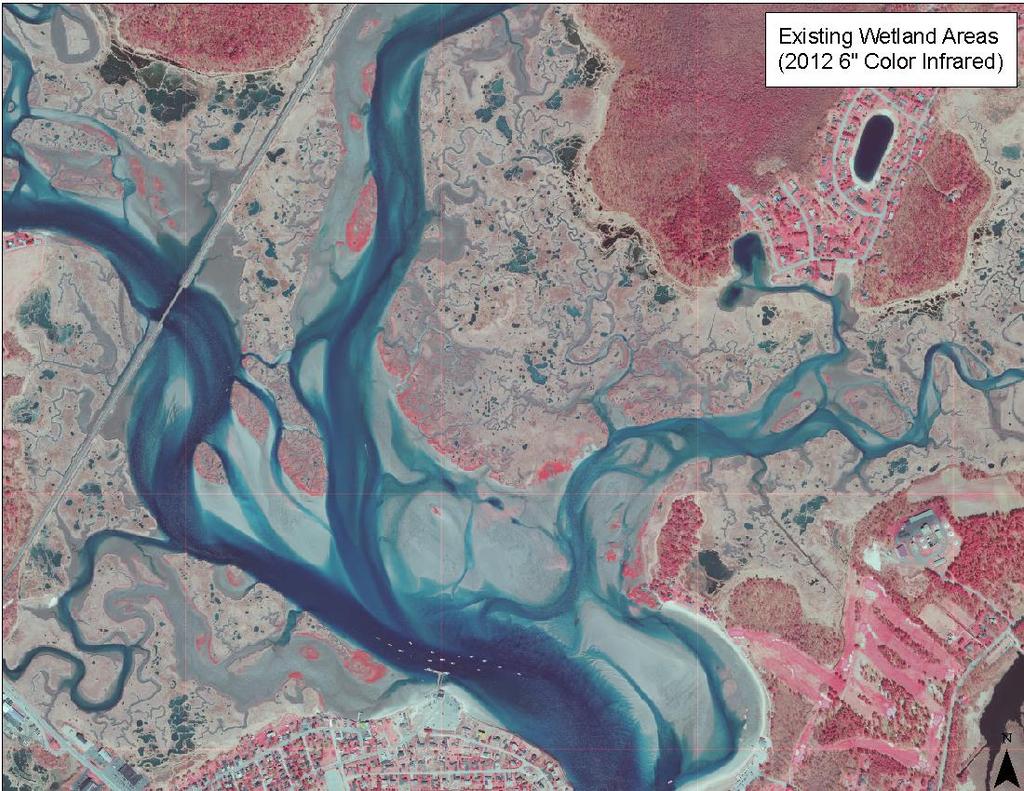
15 Coastal wetlands Coastal wetlands means all tidal and subtidal lands; all areas with vegetation present that is tolerant of salt water and occurs primarily in salt water or estuarine habitat; and any swamp, marsh, bog, beach, flat or other contiguous lowland that is subject to tidal action during the highest tide level for each year in which an activity is proposed as identified in tide tables published by the National Ocean Service. Coastal wetlands may include portions of coastal sand dunes. Required in Maine s Municipal Shoreland Zoning P.A. Slovinsky, MGS
16 Using Tidal Elevations as Proxies for the Marsh Highest Annual Tide (HAT) - spring tide, the highest predicted water level for any given year but is reached within several inches numerous tides a year Mean High Water (MHW) the averaged daily high water mark Mean Tide Level (MTL) = average height of the ocean s surface (between mean high and mean low tide). Marsh Side Ocean Side Coastal wetland Coastal Wetland - MTL to HAT Mean Tide Mean High Highest Scenario Level (MTL) Water (MHW) Annual Existing Beach Tidal elevations are determined from nearby applicable NOAA National Ocean Service/CO-OPs tidal prediction stations (Old Orchard Beach) P.A. Slovinsky, MGS
17
18

19 Very accurate method of delineating coastal wetlands!

20 What about potential changes to coastal wetland areas and wetland types? Low Marsh (MTL-MHW) High Marsh (MHW-HAT)
21 First, some Assumptions Topography stays static we are using 2010 LiDAR data that represent a snapshot of topography that may have changed. Simulations use a bathtub approach that assumes that the topography stays the same, i.e., it doesn t account for erosion, accretion, or dynamic processes like waves. Using tidal elevations as proxies for wetlands can t account for changes in tides due to tidal restrictions such as roads, etc. Although our vertical accuracy is around 6, lines and boundaries drawn on the following maps should not be deemed as absolute ; instead, they should be used for general planning purposes only.

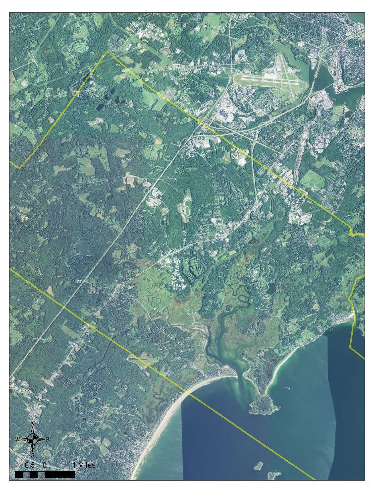
22 A detailed look: Scarborough Marsh
23 For general planning purposes only.
24 For general planning purposes only.

25 For general planning purposes only.
26 For general planning purposes only.

27 Conversion to open water For general planning purposes only.

28 For general planning purposes only.

29 State and Town-owned lands For general planning purposes only.

30 State and Town-owned lands For general planning purposes only.

31 State and Town-owned lands For general planning purposes only.

32 State and Town-owned lands For general planning purposes only.

33 For general planning purposes only. State and Town-owned lands Conversion to open water
 and Scarborough may lose marsh to open water under higher scenarios.")
34 Take home point: Wetlands may convert to a low-marsh dominated system (high marsh expansion limited by steep sloped or developed uplands) and Scarborough may lose marsh to open water under higher scenarios.
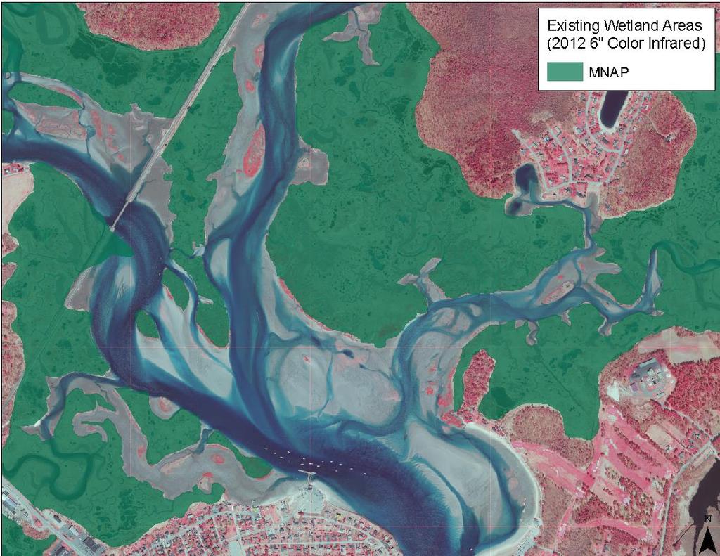
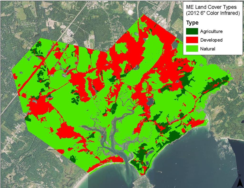
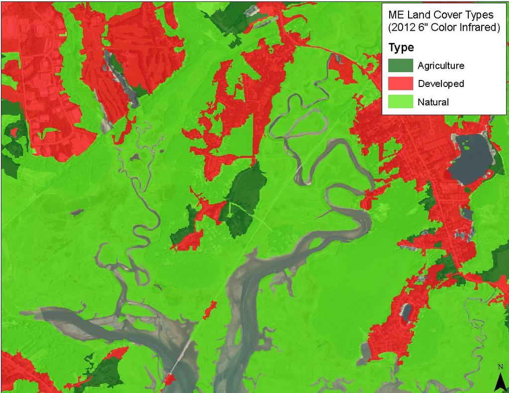
35 What kind of land cover types might be impacted? Maine Land Cover Dataset (MELCD) Multiple different land cover types grouped into 3 main categories by the Maine Natural Areas Program: Natural Developed Agricultural
36
37 Existing Conditions
38 For general planning purposes only. HAT + 1 ft SLR
39 For general planning purposes only. HAT + 2 ft SLR
40 For general planning purposes only. HAT ft SLR

41 For general planning purposes only. HAT + 6 ft SLR
42 Summary Table Potential Impacts to Adjacent Land Cover Types Scenario Maine Land Cover Type (acres)* Natural Agricultural Developed Total Cum.Total 0.3 m (1 foot) SLR m (2 feet) SLR m (3.3 feet) SLR m (6.0 feet) SLR Totals * difference in acreage from overall wetland areas is due to some areas not actually being classified by MELCD Take home point: the vast majority of land cover type (80% or more in each scenario) that may be impacted is characterized as Natural or Agricultural ; developed impacts are generally limited to undeveloped portions of parcels and existing roads
43 Summary The existing Scarborough marsh is dominated by high marsh as opposed to low marsh (73% 27%) Based on simulations, this will likely change as high marsh is pinched out against steeper sloped uplands and migrating low marsh Simulations show that Scarborough marsh will likely lose overall marsh area when compared with existing conditions, especially under higher scenarios. High marsh will be lost and low marsh will likely be converted to open water
44 Summary (cont d) Simulations show that the marsh has the potential to expand into about 1,900 acres of adjacent uplands in a 6 foot SLR scenario Based on MELCD, much of the 1,900 acres (80% or more) are in natural or agricultural land use classes. Not covered here, but several roads with major emergency access importance (especially Route 1, Black Point Road, Pine Point Road) appear to be at risk starting at a 1 foot SLR, with impacts increasing significantly with higher scenarios.

45 Available Tools Statewide sea level rise scenarios can be viewed at the Maine Geological Survey s Coastal Hazards website:
 Statewide marsh migration scenarios can be viewed at the")
46 Available Tools (cont d) Statewide marsh migration scenarios can be viewed at the Maine Natural Areas Program s website:
 Statewide coastal resiliency/land management")
47 Available Tools (cont d) Statewide coastal resiliency/land management planning tools can be viewed at ME TNC Resiliency website:
48 Thank you! Peter A. Slovinsky, Marine Geologist Maine Geological Survey (207)
Adaptation to Sea Level Rise A Regional Approach
 Adaptation to Sea Level Rise A Regional Approach Project Partners: in Saco Bay, ME Peter Slovinsky, Marine Geologist Maine Geological Survey, Department of Conservation Project Funding from: Saco Bay Hazards
Latest trends in sea level rise and storm surges in Maine Peter A. Slovinsky, Marine Geologist
 Latest trends in sea level rise and storm surges in Maine Peter A. Slovinsky, Marine Geologist Image from Chebeague.org Maine s glacial geology and historic sea level rise trends Current sea level trends
Town of Cape Elizabeth: A summary of some of the latest sea level rise science and storm surge data to help guide municipal ordinance changes
 Town of Cape Elizabeth: A summary of some of the latest sea level rise science and storm surge data to help guide municipal ordinance changes May 29, 2014 Peter A. Slovinsky, Marine Geologist Maine Geological
Turn and Face the Strange: Economic Impacts of Climate Change Sea Level Rise and Coastal Flooding E2Tech Forum June 21, 2018
 Turn and Face the Strange: Economic Impacts of Climate Change Sea Level Rise and Coastal Flooding E2Tech Forum June 21, 2018 Peter A. Slovinsky, Marine Geologist Maine Geological Survey Image from Chebeague.org
Peter A. Slovinsky, Marine Geologist Maine Geological Survey Department of Agriculture, Conserva=on and Forestry. Funding from:
 Peter A. Slovinsky, Marine Geologist Maine Geological Survey Department of Agriculture, Conserva=on and Forestry Funding from: 50% 40% Figure modified from Griggs, 2001 10% Global Sea Level Rise Driving
Town of Old Orchard Beach: A summary of sea level rise science, storm surge, and some highlighted results from SLAWG work efforts
 Town of Old Orchard Beach: A summary of sea level rise science, storm surge, and some highlighted results from SLAWG work efforts October 15, 2013 Peter A. Slovinsky, Marine Geologist Maine Geological
SECTION 13: SEA LEVEL RISE ADAPTATION
 Appropriate quote here. SECTION 13: SEA LEVEL RISE ADAPTATION 1. Statement of State and Local Goals. A. State Goals: There are currently no State goals related to sea level rise. B. Local Goals: 1. TBD
Comprehensive Plan Town of Bowdoinham Sea Level Rise and Climate Change Adaptation Goals and Strategies Draft 3 Prepared February 4, 2014
 INVENTORY AND ANALYSIS: SEA LEVEL RISE AND CLIMATE CHANGE Introduction Sea level is rising according to one hundred years of records from the Portland, ME tide gauge. Along with this change, storms are
Sea-level Rise on Cape Cod: How Vulnerable Are We? Rob Thieler U.S. Geological Survey Woods Hole, MA
 Sea-level Rise on Cape Cod: How Vulnerable Are We? Rob Thieler U.S. Geological Survey Woods Hole, MA Outline Sea-level and coastal processes Past sea-level change Predictions for the future Coastal responses
Mapping of Future Coastal Hazards. for Southern California. January 7th, David Revell, Ph.D. E.
 Mapping of Future Coastal Hazards for Southern California January 7th, 2014 David Revell, Ph.D. drevell@esassoc.com E. Vandebroek, 2012 Outline Coastal erosion hazard zones Flood hazard zones: Coastal
Adaptation to Sea Level Rise Chapter
 Adaptation to Sea Level Rise Chapter Comprehensive Plan Inventory & Analysis November 5, 2013 Planning Board of York, Maine at time of chapter adoption: Todd Frederick, Chair Al Cotton, Vice Chair Lew
NOAA s National Ocean Service. Center for Operational Oceanographic Products and Services
 NOAA s National Ocean Service Center for Operational Oceanographic Products and Services Richard Edwing, CO-OPS Acting Director January 27, 2010 Outline CO-OPS Overview Programs Observing Systems PORTS
Protecting the Storm Damage Prevention and Flood Control Interests of Coastal Resource Areas
 Protecting the Storm Damage Prevention and Flood Control Interests of Coastal Resource Areas Presented by: Massachusetts Department of Environmental Protection & Massachusetts Office of Coastal Zone Management
Promoting Resilience to Changing Weather
 Promoting Resilience to Changing Weather Harpswell Neck Harpswell Sound Orr s Island Basin Cove Pott s Point Harpswell Conservation Commission March 30, 2017 What Does This Mean for Harpswell? Topography
The Use of Geographic Information Systems to Assess Change in Salt Marsh Ecosystems Under Rising Sea Level Scenarios.
 The Use of Geographic Information Systems to Assess Change in Salt Marsh Ecosystems Under Rising Sea Level Scenarios Robert Hancock The ecological challenges presented by global climate change are vast,
Preliminary Data Release for the Humboldt Bay Sea Level Rise Vulnerability Assessment: Humboldt Bay Sea Level Rise Inundation Mapping
 Preliminary Data Release for the Humboldt Bay Sea Level Rise Vulnerability Assessment: Humboldt Bay Sea Level Rise Inundation Mapping Prepared by: Jeff Anderson, Northern Hydrology & Engineering (jeff@northernhydrology.com)
Sea Level Rise in Connecticut A Risk-Informed Approach
 GZA GeoEnvironmental, Inc. CAFM Conference October 25, 2017 Proactive By Design. Our Company Commitment Proactive By Design. Our Company Commitment Sea Level Rise in Connecticut A Risk-Informed Approach
Modeling Sea-Level Rise in Coastal Wetlands: Understanding Potential Impacts and Their Implications for Management on Cape Cod
 Modeling Sea-Level Rise in Coastal Wetlands: Understanding Potential Impacts and Their Implications for Management on Cape Cod C a p e C o a s t a l C o n f e r e n c e H y a n n i s R e s o r t a n d
Use of Elevation Data in NOAA Coastal Mapping Shoreline Products. Coastal GeoTools April 1, 2015
 Use of Elevation Data in NOAA Coastal Mapping Shoreline Products Coastal GeoTools April 1, 2015 - NOAA s Coastal Mapping Program & CUSP - Shoreline Uses, Delineation Issues, Definitions - Current Extraction
Assessing the Permanence of Blue Carbon Sinks
 Assessing the Permanence of Blue Carbon Sinks with Rising Sea Levels Gail L. Chmura and Dante D. Torio Department of Geography, McGill University and Global Environmental and Climate Change Centre Montreal,
Scenarios for the NI coast in the 21 st Century
 Scenarios for the NI coast in the 21 st Century Prof Julian Orford Geography, Archaeology & Palaeoecology Queen s University, Belfast Challenging perspective Living by the coast is good for your health!
Section 145 Climate Change and Sea Level Rise
 Section 145 Climate Change and Sea Level Rise A. Definitions Rhode Island Coastal Resources Management Program 1. Climate is the long-term weather average observed within a geographic region, and climate
The Science of Sea Level Rise and the Impact of the Gulf Stream
 Old Dominion University ODU Digital Commons July 29, 2016: The Latest in Sea Level Rise Science Hampton Roads Sea Level Rise/Flooding Adaptation Forum 7-29-2016 The Science of Sea Level Rise and the Impact
Prepared by: Ryan Ratcliffe GPH-903 December 10, 2011
 Prepared by: Ryan Ratcliffe GPH-903 December 10, 2011 Scientific studies have proven that global sea level has risen 7.1 inches in the past century and computer models have suggested that climate change
USGS efforts to model sea-level rise impact to tidal marshes along the California coast.
 USGS efforts to model sea-level rise impact to tidal marshes along the California coast. Karen Thorne 1 J.Y Takekawa 1, K. Buffington 1, K. Swanson 2, J. Drexler 2, D.Schoellhamer 2, M. Casazza 3, and
Research Background: Researcher Sam Bond taking Sediment Elevation Table (SET) measurements in the marsh. A view of salt marsh hay growing in a marsh
 measurements in the marsh. A view of salt marsh hay growing in a marsh") Name Keeping up with the sea level Featured scientist: Anne Giblin from the Marine Biological Laboratory and the Plum Island Ecosystems Long-Term Ecological Research site Research Background: Salt marshes
Name Keeping up with the sea level Featured scientist: Anne Giblin from the Marine Biological Laboratory and the Plum Island Ecosystems Long-Term Ecological Research site Research Background: Salt marshes
HURRICANE SANDY LIMITED REEVALUATION REPORT UNION BEACH, NEW JERSEY DRAFT ENGINEERING APPENDIX SUB APPENDIX C SEA LEVEL RISE ANALYSIS
 HURRICANE SANDY LIMITED REEVALUATION REPORT UNION BEACH, NEW JERSEY DRAFT ENGINEERING APPENDIX SUB APPENDIX C SEA LEVEL RISE ANALYSIS Rev. 18 Feb 2015 1.0 Introduction 1.1 Guidance The Department of the
Past, present and future
 Southern New Jersey and Delaware sea levels: Past, present and future Benjamin P. Horton Sea Level Research Department of Marine and Coastal Science Rutgers University bphorton@marine.rutgers.edu DRIVERS
Tony Pratt, DNREC to The Center for the Inland Bays Scientific and Technical Advisory Committee. August 21, 2009
 Sea Level Rise in Delaware Presented by Tony Pratt, DNREC to The Center for the Inland Bays Scientific and Technical Advisory Committee August 21, 2009 Sea level has been fluctuating ever since there have
Sea level rise Web GIS Applications
 Florida International University FIU Digital Commons GIS Center GIS Center 2018 Sea level rise Web GIS Applications Zhaohui Fu GIS-RS Center, Florida International University, Fujen@fiu.edu Sheyla Santana
Planning for Annapolis Sea Level Rise and Future Extreme Water Levels
 Planning for Annapolis Sea Level Rise and Future Extreme Water Levels U.S. Naval Academy Sea Level Rise Advisory Council 31 October 2017 CAPT Emil Petruncio, USN (Ret.), PhD Associate Professor Gina Henderson
Regardless of the politics surrounding climate change, the sea level is rising. Based on
 Analysis of Sea Level Rise Impacts in Bath, Bowdoinham, and Topsham, Maine Hannah Glover with Cam Adams, Liza LePage, and Dan Lesser ES204: Johnson 14 December 2012 INTRODUCTION Regardless of the politics
A process-based approach toward assessing the coastal impact of projected sea level rise and severe storms
 A process-based approach toward assessing the coastal impact of projected sea level rise and severe storms Patrick Barnard 1, Cheryl Hapke 2, Li Erikson 1, Amy Foxgrover 1, and Maarten van Ormondt 3 1
Carbon Sequestration Potential from Coastal Wetlands Restoration Sites
 Carbon Sequestration Potential from Coastal Wetlands Restoration Sites Insert then choose Picture select your picture. Right click your picture and Send to back. Paul Krause, Alyssa Beach Emily Cooper,
CLIMATE READY BOSTON. Climate Projections Consensus ADAPTED FROM THE BOSTON RESEARCH ADVISORY GROUP REPORT MAY 2016
 CLIMATE READY BOSTON Sasaki Steering Committee Meeting, March 28 nd, 2016 Climate Projections Consensus ADAPTED FROM THE BOSTON RESEARCH ADVISORY GROUP REPORT MAY 2016 WHAT S IN STORE FOR BOSTON S CLIMATE?
Coastal Processes 101. Greg Berman (Woods Hole Sea Grant & Cape Cod Cooperative Extension)
") Coastal Processes 101 Greg Berman (Woods Hole Sea Grant & Cape Cod Cooperative Extension) January 23, 2019 Coastal Processes 101 Outline: ~30 min talk Coastal Processes What is Erosion? Value of the Ecosystem
Coastal Processes 101 Greg Berman (Woods Hole Sea Grant & Cape Cod Cooperative Extension) January 23, 2019 Coastal Processes 101 Outline: ~30 min talk Coastal Processes What is Erosion? Value of the Ecosystem
Activity 2.2: Recognizing Change (Observation vs. Inference)
") Activity 2.2: Recognizing Change (Observation vs. Inference) Teacher Notes: Evidence for Climate Change PowerPoint Slide 1 Slide 2 Introduction Image 1 (Namib Desert, Namibia) The sun is on the horizon
Activity 2.2: Recognizing Change (Observation vs. Inference) Teacher Notes: Evidence for Climate Change PowerPoint Slide 1 Slide 2 Introduction Image 1 (Namib Desert, Namibia) The sun is on the horizon
FIG Working Week May, Bulgaria From the wisdom of the ages to the challanges of modern world
 FIG Working Week 17-21 May, Bulgaria From the wisdom of the ages to the challanges of modern world COASTAL RISK ANALYSIS OF THE BLACK SEA UNDER THE SEA LEVEL RISE N e v i n B e t u l A V S A R, S e n o
Sea-level Rise and Storm Effects on Coastal Systems under Changing Global Climate. Cape May, NJ 12 January 2009
 Sea-level Rise and Storm Effects on Coastal Systems under Changing Global Climate 2009 Delaware Estuary Science Summit Cape May, NJ 12 January 2009 S. Jeffress Williams Senior Coastal Marine Geologist
Application of the Sea-Level Affecting Marshes Model (SLAMM 6) to John Heinz NWR
 to John Heinz NWR") Application of the Sea-Level Affecting Marshes Model (SLAMM 6) to John Heinz NWR Prepared for: U. S. Fish and Wildlife Service National Wildlife Refuge System Division of Natural Resources and Conservation
Application of the Sea-Level Affecting Marshes Model (SLAMM 6) to John Heinz NWR Prepared for: U. S. Fish and Wildlife Service National Wildlife Refuge System Division of Natural Resources and Conservation
A Tutorial on Climate Change Science: The. 4 th National Climate Assessment CLIMATE SCIENCE. Don Wuebbles
 CLIMATE SCIENCE S P E C I A L R E P O R T A Tutorial on Climate Change Science: The Fourth National Climate Assessment Volume I 4 th National Climate Assessment Don Wuebbles Department of Atmospheric Sciences
Ellen L. Mecray NOAA Regional Climate Services Director, Eastern Region Taunton, MA
 Ellen L. Mecray NOAA Regional Climate Services Director, Eastern Region Taunton, MA Regions of the US National Climate Assessment What we Observe: Climate changes and impacts Increasing temperature Increasingly
Analysis of Tides and Storm Surge from Observational Records in the Delaware Inland Bays
 Analysis of Tides and Storm Surge from Observational Records in the Delaware Inland Bays John Callahan Delaware Geological Survey Coastal GeoTools Conference March 30 April 2, 2015 Charleston, SC Outline
John Callahan (Delaware Geological Survey) Kevin Brinson, Daniel Leathers, Linden Wolf (Delaware Environmental Observing System)
 Kevin Brinson, Daniel Leathers, Linden Wolf (Delaware Environmental Observing System)") John Callahan (Delaware Geological Survey) Kevin Brinson, Daniel Leathers, Linden Wolf (Delaware Environmental Observing System) Delaware is extremely vulnerable to the impacts of coastal flooding Tropical
John Callahan (Delaware Geological Survey) Kevin Brinson, Daniel Leathers, Linden Wolf (Delaware Environmental Observing System) Delaware is extremely vulnerable to the impacts of coastal flooding Tropical
MAINE STATE LEGISLATURE
 MAINE STATE LEGISLATURE The following document is provided by the LAW AND LEGISLATIVE DIGITAL LIBRARY at the Maine State Law and Legislative Reference Library http://legislature.maine.gov/lawlib Reproduced
SLR: Nuisance flooding patterns along the Coastal Bend
 SLR: Nuisance flooding patterns along the Coastal Bend Philippe Tissot Conrad Blucher Institute Resilient Texas: Planning for Sea Level Rise August 8, 2017 Hurricane Ike - 9/13/2008 Marina Photos Courtesy
Presentation Outline. Project Overview. Sea Level Rise Assessment & Decision Tools. Community Engagement. Tina Whitman, Friends of the San Juans
 Healthy Beaches for People & Fish Sea Level Rise Adaptation Tools for San Juan County, WA Tina Whitman & Andrea MacLennan December 10, 2015 Presentation Outline Project Overview Tina Whitman, Friends of
Appendix J Vegetation Change Analysis Methodology
 Appendix J Vegetation Change Analysis Methodology Regional Groundwater Storage and Recovery Project Draft EIR Appendix-J April 2013 APPENDIX J- LAKE MERCED VEGETATION CHANGE ANALYSIS METHODOLOGY Building
Modeling the Effects of Sea Level Rise on Massachusetts Coastal Wetlands Improving Protection, Management, and Climate Change Adaptation Planning
 Modeling the Effects of Sea Level Rise on Massachusetts Coastal Wetlands Improving Protection, Management, and Climate Change Adaptation Planning Photo credit: Mike McHugh, MassDEP Marc Carullo Massachusetts
Current and Future Technology Applications for Coastal Zone Management. Bruce K. Carlisle, Acting Director Office of Coastal Zone Management
 Current and Future Technology Applications for Coastal Zone Management Bruce K. Carlisle, Acting Director Office of Coastal Zone Management The Massachusetts Coastal Zone Management Program Approved in
Future Sea Level Rise and its Implications for SIDS and LDCs
 Future Sea Level Rise and its Implications for SIDS and LDCs Bill Hare, Michiel Schaeffer, Mahé Perrette, Matthias Mengel COP17, Durban, 2 nd December Overview Part 1: Global sea level: past and future
Australian Coastal Councils Conference
 Australian Coastal Councils Conference 11 March 2015 Estimating Future Coastal Inundation and Erosion Hazards Dr Andrew McCowan Dr Christine Lauchlan-Arrowsmith Warwick Bishop Background Victorian Future
How to Read These Flood Hazard Maps
 How to Read These Flood Hazard Maps The United States Geological Survey (USGS) has developed the Coastal Storms Modeling System (CoSMoS), which projects coastal flooding and erosion from coastal storms,
Cookie Settings Accept Cookies
 1 of 10 10/7/2018, 3:07 PM The U.S. East Coast is sinking, worsening floods from sea level rise 2 of 10 10/7/2018, 3:07 PM sea level rise, which has been occurring faster in the western Atlantic Ocean
Sea-Level Rise Impacts on South Florida
 Sea-Level Rise Impacts on South Florida Keren Prize Bolter, PhD Science Director, Coastal Risk Consulting. LLC 5/3/16 FAQ list What is happening? What impacts are we already seeing? Just how vulnerable
Bob Van Dolah. Marine Resources Research Institute South Carolina Department of Natural Resources
 Bob Van Dolah Marine Resources Research Institute South Carolina Department of Natural Resources Shoreline Change Will Occur! On our front beaches where it is not easy to retreat Shoreline Change Will
Active Coastal Processes in the Lubec Embayment
 The Lubec Embayment Maine Geologic Facts and Localities August, 1998 Active Coastal Processes in the Lubec Embayment 44 49 50.51 N, 66 59 34.16 W Text by Joseph T. Kelley, Department of Agriculture, Conservation
Some Thoughts on the Role of Elevation
 Some Thoughts on the Role of Elevation Data in Sea-level Rise Impact Assessments Rob Thieler* U.S. Geological Survey Coastal and Marine Geology Program Woods Hole, MA *i l d t i l d f D C h D G h *includes
Sea Level Rise and Coastal Inundation Thursday 11 th October, 2012, 1.00pm, With lunch in the Legislative Council Committee Room
 The Presiding Officers invite Parliamentarians and Staff to a Science Briefing on Sea Level Rise and Coastal Inundation Thursday 11 th October, 2012, 1.00pm, With lunch in the Legislative Council Committee
Module 2, Investigation 4: Log 1 Our coasts
 Module 2, Investigation 4: Log 1 Our coasts The coast is where the ocean meets land. Coastlines are always changing their shape. They are being worn away in some places and built up in others. Coasts can
Assessing Sea Level Rise, Storm Surge and Flooding Risks at the Ogunquit Wastewater Treatment Facility COMMITMENT & INTEGRITY DRIVE RESULTS
 Assessing Sea Level Rise, Storm Surge and Flooding Risks at the Ogunquit Wastewater Treatment Facility September 27, 2012 Presentation Outline Reasons for the Study Sea Level Rise, Storm Surge & Flooding
New Jersey Department of Transportation Extreme Weather Asset Management Pilot Study
 New Jersey Department of Transportation Extreme Weather Asset Management Pilot Study Overview Prepared for: June 26, 2018 Introduction Overview of Pilot Study New Jersey s Climate New Jersey s Transportation
Coastal Vulnerability Assessment in Semarang City, Indonesia Based on Sea Level Rise and Land Subsidence Scenarios
 Coastal Vulnerability Assessment in Semarang City, Indonesia Based on Sea Level Rise and Land Subsidence Scenarios I. M. Radjawane, D. Hartadi and W. R. Lusano Oceanography Research Division Fac. of Earth
Sea Level Rise Study Summary Town of South Bethany
 Sea Level Rise Study Summary Town of South Bethany This presentation was prepared by Anchor QEA for the Town of South Bethany using Federal Funds under award NA14 NOS 419 0123 from the Delaware Coastal
Coastal Barrier Island Network (CBIN): Management strategies for the future
: Management strategies for the future") Coastal Barrier Island Network (CBIN): Management strategies for the future Heather Joesting*, Amy Williams**, Rusty Feagin**, and William K. Smith* *Department of Biology, Wake Forest University, Winston
Coastal Barrier Island Network (CBIN): Management strategies for the future Heather Joesting*, Amy Williams**, Rusty Feagin**, and William K. Smith* *Department of Biology, Wake Forest University, Winston
Assessing the local impacts of sea level rise
 Assessing the local impacts of sea level rise Ian Miller, Coastal Hazards Specialist Washington Sea Grant MRC Conference Port Townsend, WA 5 December 2014 With contributions from: Eric Grossman, USGS;
Beyond 2100: Committed Sea Level Rise in South Florida Produced by 21st Century Global Temperature Rise
 Beyond 2100: Committed Sea in South Florida Produced by 21st Century Global Temperature Rise Presented by: Pete Harlem Presented at GIS Day November 6, Pete Harlem, Jack Meeder and Randy Parkinson It s
Dynamic Coast. Coastal erosion / Management Briefing to THC
 Dynamic Coast Coastal erosion / Management Briefing to THC What is Dynamic Coast? Dynamic Coast is a Scottish Government project, funded by CREW, managed by SNH, with a research team from the University
Shoreline and Climate Change Adaptation Alternatives for The Letter Parcel, Bolinas Lagoon
 Shoreline and Climate Change Adaptation Alternatives for The Letter Parcel, Bolinas Lagoon Scenic shoreline vista of Bolinas Lagoon and ridges, from Letter Parcel, March 2016 Peter Baye, Coastal Ecologist
Application of the Sea-Level Affecting Marshes Model (SLAMM 6) to Back Bay NWR
 to Back Bay NWR") Application of the Sea-Level Affecting Marshes Model (SLAMM 6) to Back Bay NWR U. S. Fish and Wildlife Service National Wildlife Refuge System Division of Natural Resources and Conservation Planning Conservation
Application of the Sea-Level Affecting Marshes Model (SLAMM 6) to Back Bay NWR U. S. Fish and Wildlife Service National Wildlife Refuge System Division of Natural Resources and Conservation Planning Conservation
Appendix B. SLAMM Analysis of Kenai Peninsula and Anchorage, AK. Final Report
 Appendix B SLAMM Analysis of Kenai Peninsula and Anchorage, AK Final Report For: Jim Adams Director, Pacific Region National Wildlife Federation Anchorage, AK And: David Wigglesworth Coastal Program Manager
COASTAL DATA APPLICATION
 2015 Coastal GeoTools Proactive By Design. Our Company Commitment COASTAL DATA APPLICATION Projecting Future Coastal Flood Risk for Massachusetts Bay Bin Wang, Tianyi Liu, Daniel Stapleton & Michael Mobile
Sea Level Rise Providing Nature A-Right-of Way
 Sea Level Rise Providing Nature A-Right-of Way Study Area Site 2: Skagit Bay Initial Condition 11.2 Inches by 2050 No Dikes 27.3 Inches by 2100 No Dikes The Problem Loss of coastal wetlands due to submergence
A System View of Water Level Processes in the Lower Columbia River
 A System View of Water Level Processes in the Lower Columbia River David Jay Department of Civil & Environmental Engineering Portland State University, Portland, OR Amy Borde and Heida Diefenderfer Pacific
GIS & Remote Sensing in Mapping Sea-Level Rise (SLR)
") Joe McGuire NRS-509 Concepts in GIS & Remote Sensing Professors August & Wang Due 12/10/2015 11:30am GIS & Remote Sensing in Mapping Sea-Level Rise (SLR) The ever-present threat of global warming and a
Joe McGuire NRS-509 Concepts in GIS & Remote Sensing Professors August & Wang Due 12/10/2015 11:30am GIS & Remote Sensing in Mapping Sea-Level Rise (SLR) The ever-present threat of global warming and a
Planning for the Future of Humboldt Bay: Sea Level Rise, Sediment Management, Sand Spits and Salt Marshes. Joel Gerwein
 Planning for the Future of Humboldt Bay: Sea Level Rise, Sediment Management, Sand Spits and Salt Marshes Joel Gerwein Introduction to Humboldt Bay Setting Economy, community, and environment Sediment
NOAA National Centers for Environmental Information State Summaries 149-FL. Observed and Projected Temperature Change
 19-FL FLORIDA Key Messages Under a higher emissions pathway, historically unprecedented warming is projected by the end of the 1st century. Rising temperatures will likely increase the intensity of naturally-occurring
Limits and Potentials of High Resolution Terrestrial Laser Scanning in Monitoring Estuarine Geomorphologic Variability.
 Limits and Potentials of High Resolution Terrestrial Laser Scanning in Monitoring Estuarine Geomorphologic Variability Charlie Endris January 20, 2010 Elkhorn Slough: Erosion and Habitat Loss Evolution
BECQ 2017 SLR Map Layer Updates: Methodology for Coastal Flood Geoprocessing
 BECQ 2017 SLR Map Layer Updates: Methodology for Coastal Flood Geoprocessing This paper summarizes the local and regional sea level data used to develop coastal flooding scenarios for the island of Saipan,
Climates of NYS. Definitions. Climate Regions of NYS. Storm Tracks. Climate Controls 10/13/2011. Characteristics of NYS s Climates
 Definitions Climates of NYS Prof. Anthony Grande 2011 Weather and Climate Weather the state of the atmosphere at one point in time. The elements of weather are temperature, air pressure, wind and moisture.
Physical Dynamics of the Coastal Zone in the Mediterranean on Annual to Decadal Scales
 Physical Dynamics of the Coastal Zone in the Mediterranean on Annual to Decadal Scales Hans-Peter Plag Nevada Bureau of Mines and Geology and Seismological Laboratory University of Nevada, Reno, Nevada,
Definitions Weather and Climate Climates of NYS Weather Climate 2012 Characteristics of Climate Regions of NYS NYS s Climates 1.
 Definitions Climates of NYS Prof. Anthony Grande 2012 Weather and Climate Weather the state of the atmosphere at one point in time. The elements of weather are temperature, t air pressure, wind and moisture.
Flood and Sea Level Rise Mapping Methodologies: The Way Forward
 Flood and Sea Level Rise Mapping Methodologies: The Way Forward Malcolm L. Spaulding Professor Emeritus, Ocean Engineering University of Rhode Island spaulding@egr.uri.edu Interagency Coordination Meeting
Great Lakes Update. Volume 194: 2015 Annual Summary
 Great Lakes Update Volume 194: 2015 Annual Summary Background The U.S. Army Corps of Engineers (USACE) tracks and forecasts the water levels of each of the Great Lakes. This report summarizes the hydrologic
CASE STUDY: A combination of processes creates extreme water levels and contributes to flooding and erosion
 CASE STUDY: A combination of processes creates extreme water levels and contributes to flooding and erosion Episodic extreme water level events pose a serious risk to Pacific Island regions. Higher than
Coastal Processes and Shoreline Erosion on the Oregon Coast, Cascade Head to Cape Kiwanda
 State of Oregon Department of Geology and Mineral Industries Vicki S. McConnell, State Geologist Open File Report OFR O-04-11 Coastal Processes and Shoreline Erosion on the Oregon Coast, Cascade Head to
Sea Level Rise in Miami-Dade County Florida Implications for Management of Coastal Wetlands and the Everglades
 Sea Level Rise in Miami-Dade County Florida Implications for Management of Coastal Wetlands and the Everglades Peter W. Harlem Dr. John F. Meeder Florida International University Southeast Environmental
Application #: TEXT
 TOWN OF FORT MYERS BEACH 2008 PROPOSED COMPREHENSIVE PLAN AMENDMENTS Application #: 2008-13-TEXT Description: Modify the Coastal Management and Future Land Use Elements to reflect the state s new definition
ESTIMATION OF LANDFORM CLASSIFICATION BASED ON LAND USE AND ITS CHANGE - Use of Object-based Classification and Altitude Data -
 ESTIMATION OF LANDFORM CLASSIFICATION BASED ON LAND USE AND ITS CHANGE - Use of Object-based Classification and Altitude Data - Shoichi NAKAI 1 and Jaegyu BAE 2 1 Professor, Chiba University, Chiba, Japan.
COASTAL QUATERNARY GEOLOGY MAPPING FOR NSW: EXAMPLES AND APPLICATIONS
 COASTAL QUATERNARY GEOLOGY MAPPING FOR NSW: EXAMPLES AND APPLICATIONS A Troedson Geological Survey of New South Wales Abstract Detailed geological mapping of the coastal plains of regional NSW was undertaken
A Perfect Storm: The Collision of Tropical Cyclones, Climate Change and Coastal Population Growth. Jeff Donnelly Woods Hole Oceanographic Institution
 A Perfect Storm: The Collision of Tropical Cyclones, Climate Change and Coastal Population Growth Jeff Donnelly Woods Hole Oceanographic Institution Recent Hurricane Trends What Might the Future Hold?
TRB First International Conference on Surface Transportation Resilience
 TRB First International Conference on Surface Transportation Resilience Applying the Sea-Level Scenario Sketch Planning Tool to Enhance the Resilience of Long-Range Transportation Plans: Lessons Learned
Miami-Dade County Technical Update Meeting South Florida Coastal Study. May 11, 2016
 Miami-Dade County Technical Update Meeting South Florida Coastal Study May 11, 2016 Welcome and Introductions FEMA Region IV Christina Lindemer Technical Lead Production and Technical Services (PTS) Contractor
Sea level change around the Philippines
 Sea level Sea level around the Philippines Institute of Environmental Science for Social Change (ESSC) Conference on Internal Migration and Displacement Davao City, Philippines 20 May 2012 Regional How
The Coast: Beaches and Shoreline Processes
 1 2 3 4 5 6 7 8 9 The Coast: es and Shoreline Processes Trujillo & Thurman, Chapter 10 Oceanography 101 Chapter Objectives Recognize the various landforms characteristic of beaches and coastal regions.
Rising Sea Levels: Time for Proactive Action in Florida and the Caribbean?
 Rising Sea Levels: Time for Proactive Action in Florida and the Caribbean? Dr. Alan Fyall and Dr. Thomas Wahl National Center for Integrated Coastal Research, University of Central Florida Dr. Roberta
Integrating Climate Adaptation in Hawaii Disaster Risk Management
 Integrating Climate Adaptation in Hawaii Disaster Risk Management Building Resilient Communities HCPO/HIGICC 2009 Conference September 23-25 Sheraton Waikiki Introduction What are weather/climate-related
Maine Coastal Property Owner s Guide to Erosion, Flooding, and Other Hazards
 Maine Coastal Property Owner s Guide to Erosion, Flooding, and Other Hazards Peter A. Slovinsky, Marine Geologist, Maine Geological Survey Purpose of this Guide The Maine Geological Survey created this
The Coast: Beaches and Shoreline Processes Trujillo & Thurman, Chapter 10
 The Coast: es and Shoreline Processes Trujillo & Thurman, Chapter 10 Oceanography 101 Chapter Objectives Recognize the various landforms characteristic of beaches and coastal regions. Identify seasonal
Climate Change: Understanding Recent Changes in Sea Level and the Ocean. Sea Level Rise
 Climate Change: Understanding Recent Changes in Sea Level and the Ocean Sea Level Rise Philip L. Woodworth Proudman Oceanographic Laboratory, Liverpool ASE/BA/City of Culture Evening 18 October 2007 Long